POLAR WEEKEND SHRINKING ICE SHEETS AND RISING SEA LEVEL
|
|
|
- Antony Horton
- 6 years ago
- Views:
Transcription


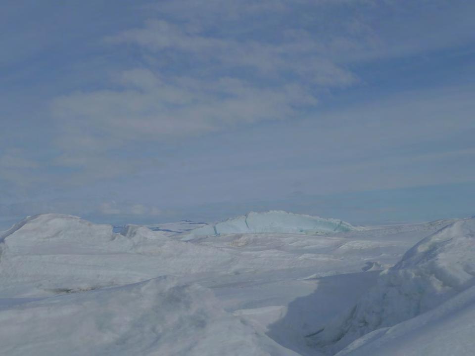
1 POLAR WEEKEND SHRINKING ICE SHEETS AND RISING SEA LEVEL TOPIC: Shrinking Ice Sheets and Rising Sea Levels PROJECT PERSONNEL: Dr. Robert Bindschadler, Glaciologist, NASA Scientists provide information on what they see, measure and record it is up to the public to be the stewards of the planet. PHOTO: Dr. Bob dressed in his Antarctic parka in the field on the West Antarctic Peninsula WHERE ON THE MAP ARE WE? The Antarctic continent is divided into two main parts - East and West with the Transantarctic Mountains being the dividing line. Dr. Bob s research has focused on the West Antarctic Ice Sheet (WAIS), and specifically during IPY was focused on the Pine Island Glacier (called PIG on this map) the most active glacier anywhere in Antarctica. In fact, he and his team were the first people to actually set foot on the PIG ice shelf! In the winter the temperature drops to -50 degrees C and the winds are fierce! PIG is ~ 2300 km (1400 miles) from McMurdo Station, the U.S. Antarctic Program s main base. GENERAL BACKGROUND INFORMATION ON THE SUBJECT: Ice sheets change sea level as they grow and shrink. Humans are vulnerable to rapid changes in sea level because the coasts are developed economically with tourism and trade and 1/3 of the world s population lives within the coastal zone. What kind of threat is Sea Level Rise (SLR)? Lamont-Doherty Earth Observatory Polar Weekend Shrinking Ice Sheets - 1
2 One of the things we don t understand well is the role of ice sheets and glaciers in SLR. We do know that Ice Shelves are important because they act like a wall holding back ice streams that bring ice from the glacier flowing off the edges of the continent and into the oceans. Once the ice shelves melt or break away they release the ice streams the flow behind them causing them to speed up bringing more and more ice to the ocean. Another way to think about it is the ice shelf is like popping the cork out of a bottle. Ice sheets themselves don t add to SLR since they are already floating, but continental ice that starts out on the land once it is added to the oceans WILL contribute to SLR. Red areas will flood with 1 meter of SLR. WHAT IS SO IMPORTANT ABOUT PIG? PIG, a glacier that is ~40 km (25 miles) long and 20 km wide (12 miles), is the most active glacier in Antarctica and is thinning rapidly. Its movement has been measured at a rate of 10 meters a day (that is more than 1 ft. an hour)! Remarkably you can t feel it move when you are standing on it. This fast moving glacier is moving ice quickly to the ocean. PIG is one of two major glaciers that drain the West Antarctic Ice Sheet, draining an area that could add 1 meter of SLR (see the map above to see what type of impact that could have). Economists estimate this could cost the world economy ~ $1 trillion dollars. But how long will all this take? Scientists are trying to figure this out. WHAT DID THE TEAM GET DONE? The plan was: 1) to set up a camp so that in the future drilling could be done through the ice shelf to install instruments and cameras into the sea below the ice; 2) install 2 GPS receivers to measure movement in the ice sheet to see if it was accelerating; and 3) to set up an automatic weather station (AWS) on PIG since this area is a gap in the weather information. The problem was that the ice sheet was filled with crevasses and it was too difficult to land the plane and bring all the necessary gear into the area. The GPS was only 3 lbs but the back up battery was 1000 lbs, and then there were the solar panels to run everything! In the end no camp was built but a 14 ft. tall weather station was installed and 2 GPS were positioned right next to the ice shelf. The station was installed using a dead man under each foot! WHAT? Check the vocabulary! TERMS YOU SHOULD KNOW (VOCABULARY): Ice sheets: Also known as continental glaciers a mass of glacier ice that provides a continuous cover on the surrounding land area and is greater in size than 50,000 square kms. Lamont-Doherty Earth Observatory Polar Weekend Shrinking Ice Sheets - 2

3 Sea level the average measure of the ocean s surface, used as a way of determining land elevation. Crevasse fast moving sections of ice streams cause cracks or fractures in the glacier. These cracks can be tens of meters across, hundreds of meters long and very deep if you fell in. AND A FUN ONE! Dead Man: Wood buried in the snow to spread the weight of the feet of an instrument so that the poles don t sink straight down into the snow. WHY ARE WE STUDYING THIS IN THE POLAR REGIONS? Ice sheets are remote, but when they change size, their effect on sea level is direct and immediate. Experts expect sea level to rise by one meter (over 3 feet) this century. HOW DOES THIS AFFECT US HERE IN THE UNITED STATES? 50% of the US population lives near the coast. Globally, 145 million people will have to move if sea level rises one meter. TO LEARN MORE ABOUT THIS TOPIC: Find out how much ice is in the ice sheets and how much sea level would rise if all glaciers, or the Greenland ice sheet, or the Antarctic ice sheet flowed or melted away. ACTIVITES YOU CAN TRY: Dr. Bob with students at the Polar Fair Different Folks have Different Coasts: Intro: Ice sheets matter to people across the globe because ice sheets change size, contributing more or less water to the oceans. This changes sea level and the coastline, where the ocean meets the land. The impact to people at any point along the coastline depends on many factors like whether there are houses or roads at the sea's edge, the erodability of the land there and the range of the tide and strength of the waves. Another factor is the slope of the land and it is that factor that the demonstration focuses on. Supplies: (see photo for clarification) Jug of water colored blue Ice cubes or crushed works fine Lightweight plastic circular container (to be Antarctica see photo) Photos printed out to tape around Antarctica and to add around the global oceans as desired Toys or props as desired for workers in Antarctica and houses to add to the shorelines Dishwasher tub or cat litter tray to represent the world s oceans Two flat boards to represent shoreline Small ruler (measured in cms preferably) Lamont-Doherty Earth Observatory Polar Weekend Shrinking Ice Sheets - 3


4 Dr. Bob and a set up for his activity Different Folks have Different Coasts - SLR Activity Set up: Coasts with two different slopes are presented along with a distant melting ice sheet that slowly raises sea level. Create samples of two different shorelines using two sections of thin plywood or thin plastic of equal length set up at two different inclines. Draw lines to exemplify sea level - you can do this in one of two ways: 1) Space lines on the board so that one is twice the difference of the other i.e. 8 mm apart on one board and 16 mm apart on the second board (see photo) or 2) Create both boards with lines the same dimension apart i.e. 5 cm on each board. Number the lines starting with #1 on the bottom line and moving upward to as many lines as you have on the boards. Boards can be decorated with monopoly houses and vegetation to show residences and landscape. Set the small incline boards in the dish or cat tub. The two boards should be propped at differing inclines to replicate differing shorelines, with one inclined at twice the angle of the other board. This can be done if blocks, with one block twice as high as the other, support the boards. If you spaced your lines with one marked at twice the distances as the other be sure the one with tightly spaced lines is inclined at twice the angle as the other board. Although not included in the picture, we would suggest you tape a small ruler (marked in cms) onto the inside wall of the tube to serve as a tide marker. This will show how many cms of water are added to sea level. You can print out images of shorelines to add around the edges of the tube representing the different landmasses that will be impacted by changing sea level. Create Antarctica: Antarctica is a round plastic tub. A small hole is popped into one corner of the tub with the tub elevated and filled with ice. Use the attached image to create Antarctica! Print out this image, cut and tape it together and wrap it around a plastic tub (you might need to print more than one copy). Place the round Antarctica plastic tub on an elevated surface (several books work) with the small hole set out so that it drains into the dish tub. This represents Antarctica and its continental ice sheet melting into the global oceans. Now fill the Antarctic tube with ice. You are ready to start! Slowly add some of the blue tinted water into the Antarctic display. Watch is melts some of the ice and flows into the global ocean raising water level. Using the tide stick note how much sea level has risen? What is the effect on the two different shorelines? Summary: The demonstration shows that the sea moves inland faster along the shore that is shallower. Lines drawn on the two shores emphasize how much more inland intrusion will occur for the shallower shore. Lamont-Doherty Earth Observatory Polar Weekend Shrinking Ice Sheets - 4

5 Continental Ice Versus Floating Ice Shelf: You will need two clear glasses and some ice. Put 4 ice cubes in one glass and fill to two thirds full with water. Finish by marking the level of the water on the side of the glass. This will represent your floating ice shelf. Fill the second glass with water to two thirds full and mark the level on the outside of the glass. After marking the water level add 3 to 4 ice cubes. This represents your continental ice. Make a prediction: Once it melts, which ice loss will change the water level? Why? Recall what Dr. Bob said about the problem with the loss of a melting ice shelf. What purpose did he say the ice shelf was serving? Pull it all together: What is the concern with loosing Continental Ice? with loosing an Ice Shelf? What is the concern Experiment with Ice Flow: Make a recipe of Flubber to experiment with ice flow (see FILMS YOU CAN WATCH: You can watch Dr. Bob in the field and learn a lot more at the following locations: Lamont-Doherty Earth Observatory Polar Weekend Shrinking Ice Sheets - 5
6

 solid vs.")

 GLOBAL IMPACT Red areas will flood with")


7 ICE and WATER ice Ice sheets are made of Oceans are made of water GAIN and LOSS Ice sheets grow by snowfall melting Ice sheets shrink by & flow Same stuff; different form (or phase ) solid vs. liquid PAST and FUTURE Sea Level is rising faster and faster 2 cm. 6 cm. with 1700 s 1800 s 1900 s this century (current rate) GLOBAL IMPACT Red areas will flood with 1-meter rise in sea level 19 cm. 31 cm. Impact of 1-meter rise: 2,200,000 sq. km will flood; 145 million people must move; $944,000,000,000 will be lost 1-meter rise in sea level is likely by 2100 LOCAL IMPACT 1 meter vertical = 1000 m horizontal Dr. Robert Bindschadler Extra water added to the oceans each century Warmer ice sheets flow faster into the ocean A small rise in sea level moves the shoreline A LOT!!
How Will Melting Ice Sheets Affect Us?
 PASSAGE 4 How Will Melting Ice Sheets Affect Us? Variation is normal. During the last ice age, for example, ice sheets also covered much of North America and Scandinavia. Why is what s happening now different
Ice Sheets and Sea Level -- Concerns at the Coast (Teachers Guide)
") Ice Sheets and Sea Level -- Concerns at the Coast (Teachers Guide) Roughly 153 million Americans (~53% of the US population) live in coastal counties. World wide some 3 billion people live within 200 km
Ice Sheets and Sea Level -- Concerns at the Coast (Teachers Guide) Roughly 153 million Americans (~53% of the US population) live in coastal counties. World wide some 3 billion people live within 200 km
SEA ICE AND GLOBAL WARMING
 jkjk SEA ICE AND GLOBAL WARMING Lesson plan for grades K- 3 By: Laura Sanders, Environmental Science Institute, March 2011 Length of lesson: two 30- minute class periods SOURCES AND RESOURCES: Atmospheric
GOING WITH THE FLOW (1 Hour)
") GOING WITH THE FLOW (1 Hour) Addresses NGSS Level of Difficulty: 3 Grade Range: 3-5 OVERVIEW In this activity, students use a stream table to model the processes of erosion and streambed formation. The
GOING WITH THE FLOW (1 Hour) Addresses NGSS Level of Difficulty: 3 Grade Range: 3-5 OVERVIEW In this activity, students use a stream table to model the processes of erosion and streambed formation. The
EROSIONAL FEATURES. reflect
 reflect Have you ever looked at the land around you and wondered what processes shaped what you see? Perhaps you see mountains, valleys, rivers, or canyons. Do you know how long these geologic features
Think about the landforms where you live. How do you think they have changed over time? How do you think they will change in the future?
 reflect All the landforms on Earth have changed over time and continue to change. Many of the changes were caused by wind, moving water, and moving ice. Mountains have grown and shrunk. Rivers have cut
Erosional Features. What processes shaped this landscape?
 Have you ever looked at the land around you and wondered what processes shaped what you see? Perhaps you see mountains, valleys, rivers, or canyons. Do you know how long these geologic features have been
Changes to Land 5.7B. landforms: features on the surface of Earth such as mountains, hills, dunes, oceans and rivers
 All the landforms on Earth have changed over time and continue to change. Many of the changes were caused by wind, moving water, and moving ice. Mountains have grown and shrunk. Rivers have cut away land
Module 7, Lesson 1 Water world
 Module 7, Lesson 1 Water world Imagine that the year is 2100. Scientists have determined that the rapidly warming climate of the earth will cause the ice sheets of Antarctica to break apart and melt at
NASA Images of Antarctica and the Arctic covered in both land and sea ice
 ICE SHELVES ACTIVITY 1: DECODING THE ROLE OF ANTARCTIC ICE IN GLOBAL CLIMATE Ice Shelves play a critical role in Antarctica, serving as a buffer between the ocean and the continental ice sheet covering
Module 7, Lesson 1 Water world
 Module 7, Lesson 1 Water world Imagine that the year is 2100. Scientists have determined that the rapidly warming climate of the earth will cause the ice sheets of Antarctica to break apart and melt at
ACTIVITY II: THE FATE OF THE LARSEN S, A FAMILY OF ANTARCTIC ICE SHELVES
 ACTIVITY II: THE FATE OF THE LARSEN S, A FAMILY OF ANTARCTIC ICE SHELVES Ice Shelves play a critical role in Antarctica, serving as a buffer between the ocean and the continental ice sheet covering the
EROSION RATES (1 Hour)
") EROSION RATES (1 Hour) Addresses NGSS Level of Difficulty: 2 Grade Range: 3-5 OVERVIEW In this activity, students will conduct simple investigations to collect data on erosion rates of different Earth
EROSION RATES (1 Hour) Addresses NGSS Level of Difficulty: 2 Grade Range: 3-5 OVERVIEW In this activity, students will conduct simple investigations to collect data on erosion rates of different Earth
TEACHER PAGE Trial Version
 TEACHER PAGE Trial Version * After completion of the lesson, please take a moment to fill out the feedback form on our web site (https://www.cresis.ku.edu/education/k-12/online-data-portal)* Lesson Title:
UNSTOPPABLE COLLAPSE OF THE WEST ANTARCTIC ICE SHEET IS NOT HAPPENING
 UNSTOPPABLE COLLAPSE OF THE WEST ANTARCTIC ICE SHEET IS NOT HAPPENING Dr. Don J. Easterbrook, Western Washington University, Bellingham, WA May 19, 2014 A New York Times headline reads Scientists Warn
CLIMATE READY BOSTON. Climate Projections Consensus ADAPTED FROM THE BOSTON RESEARCH ADVISORY GROUP REPORT MAY 2016
 CLIMATE READY BOSTON Sasaki Steering Committee Meeting, March 28 nd, 2016 Climate Projections Consensus ADAPTED FROM THE BOSTON RESEARCH ADVISORY GROUP REPORT MAY 2016 WHAT S IN STORE FOR BOSTON S CLIMATE?
The Environmental Literacy Framework (ELF) was made possible through financial support provided by
 was made possible through financial support provided by") The Environmental Literacy Framework (ELF) was made possible through financial support provided by Energy Geosphere As part of NOAA Environmental Literacy Grant #NA09SEC490009 to the University of Nebraska
The Environmental Literacy Framework (ELF) was made possible through financial support provided by Energy Geosphere As part of NOAA Environmental Literacy Grant #NA09SEC490009 to the University of Nebraska
1 Earth s Oceans. TAKE A LOOK 2. Identify What are the five main oceans?
 CHAPTER 13 1 Earth s Oceans SECTION Exploring the Oceans BEFORE YOU READ After you read this section, you should be able to answer these questions: What affects the salinity of ocean water? What affects
Antarctica s Climate Secrets Poster 5. Decoding Antarctica s Climate History
 Decoding Antarctica s Climate History Decoding Antarctica s Climate History Scientists are working to uncover and decode Antarctica s climate secrets. In order to piece together a complete story, they
The continent of Antarctica Resource N1
 The continent of Antarctica Resource N1 Prepared by Gillian Bunting Mapping and Geographic Information Centre, British Antarctic Survey February 1999 Equal area projection map of the world Resource N2
Overview: Key Concepts: Time: 2, minute class periods. Materials:
 Text and Activities Adapted from: Teachers Domain, Texas A&M University: Ocean Drilling Distance Learning Program, The New York Times, Center for Remote Sensing of Ice Sheets (CReSIS), the Natural Resources
C E C U R R I C U L U M I E N S C B L E I T A. i N T E G R A T I N G A R T S i n O N A T I D U C B L I P U. Student Learning Objectives:
 We athering E Q U I T A B L E S C I E N C E C U R R I C U L U M Lesson 1 i N T E G R A T I N G A R T S i n P U B L I C E D U C A T I O N NGSS Science Standard: 4-ESS1-1 Identify evidence from patterns
Exploring The Polar Connection to Sea Level Rise NGSS Disciplinary Core Ideas Science & Engineering Crosscutting Concepts
 Exploring The Polar Connection to Sea Level Rise NGSS Disciplinary Core Ideas Science & Engineering Crosscutting Concepts Practices MS - ESS: Earth & Space Science 1. Ask questions 2. Developing and using
Thanks. You Might Also Like. I look forward helping you focus your instruction and save time prepping.
 Thanks Connect Thank you for downloading my product. I truly appreciate your support and look forward to hearing your feedback. You can connect with me and find many free activities and strategies over
Activity 2.2: Recognizing Change (Observation vs. Inference)
") Activity 2.2: Recognizing Change (Observation vs. Inference) Teacher Notes: Evidence for Climate Change PowerPoint Slide 1 Slide 2 Introduction Image 1 (Namib Desert, Namibia) The sun is on the horizon
Activity 2.2: Recognizing Change (Observation vs. Inference) Teacher Notes: Evidence for Climate Change PowerPoint Slide 1 Slide 2 Introduction Image 1 (Namib Desert, Namibia) The sun is on the horizon
Lesson 2. Antarctic Oceanography: Component I - Ice/Glaciers Component II - Marine Snow
 Lesson 2. Antarctic Oceanography: Component I - Ice/Glaciers Component II - Marine Snow Lesson Objectives: Introduces students to the different kinds of ice found in Antarctica, Students will become familiar
Name. 4. The diagram below shows a soil profile formed in an area of granite bedrock. Four different soil horizons, A, B, C, and D, are shown.
 Name 1. In the cross section of the hill shown below, which rock units are probably most resistant to weathering? 4. The diagram below shows a soil profile formed in an area of granite bedrock. Four different
Notes and Summary pages:
 Topographic Mapping 8.9C Interpret topographical maps and satellite views to identify land and erosional features and predict how these shapes may be reshaped by weathering ATL Skills: Communication taking
UNIT 1: WATER SYSTEMS ON EARTH CHAPTER 2: OCEANS CONTROL THE WATER CYCLE
 UNIT 1: WATER SYSTEMS ON EARTH CHAPTER 2: OCEANS CONTROL THE WATER CYCLE ORIGINS OF OCEAN WATER OCEANS HAVE FILLED OVER HUNDREDS OF MILLIONS OF YEARS SCIENTISTS BELIEVE THE OCEANS ARE MORE THAN 3 BILLION
MCMURDO DRY VALLEYS ANTARCTICA
 POLAR WEEKEND MCMURDO DRY VALLEYS ANTARCTICA TOPIC: The McMurdo Dry Valleys, An Ecosystem of microbial life PROJECT PERSONNEL: Dr. Andrew G. Fountain, Geologist, Portland State University, Portland Oregon
C E C U R R I C U L U M I E N S C B L E I T A. i N T E G R A T I N G A R T S i n O N A T I D U C B L I P U. Student Learning Objectives:
 Sedimentation E Q U I T A B L E S C I E N C E C U R R I C U L U M Lesson 3 i N T E G R A T I N G A R T S i n P U B L I C E D U C A T I O N NGSS Science Standard: 4-ESS1-1 Identify evidence from patterns
Ice sheets of West Antarctica are warming fast. West Antarctic Ice Sheet warming twice earlier estimate
 Ice sheets of West Antarctica are warming fast 02 January 2013 Magazine issue 2898. Subscribe and save For similar stories, visit the Climate Change Topic Guide THE ice sheets of West Antarctica are warming
Read Across America. Listen as I read for facts about Volcanoes. In the Shadow of the Volcano
 Read Across America Listen as I read for facts about Volcanoes. In the Shadow of the Volcano Constructive & Destructive Processes Earth s surface is always changing. Blowing wind and flowing water causes
Surface Circulation in the North Atlantic & off of Southern California: Two Models
 Surface Circulation in the North Atlantic & off of Southern California: Two Models Objective 1. To become familiar with large scale surface circulation patterns in ocean. 2. To be able to predict current
The grade 5 English science unit, Weather, meets the academic content standards set in the Korean curriculum, which state students should:
 Among the diverse meteorological elements, this area focuses on humidity, dew, fog, clouds, rain, snow, wind and atmospheric pressure. Weather influences not only our daily outdoor activities, but also
POLAR WEEKEND SUBGLACIAL LAKES
 POLAR WEEKEND SUBGLACIAL LAKES TOPIC: AN Unknown Subglacial World CHRISTOPHER SHUMAN, UNIVERSITY OF ADRIENNE BLOCK, LDEO MARYLAND BALTIMORE COUNTY'S GODDARD EARTH SCIENCE AND TECHNOLOGY CENTER PROJECT
Module 2, Investigation 4: Log 1 Our coasts
 Module 2, Investigation 4: Log 1 Our coasts The coast is where the ocean meets land. Coastlines are always changing their shape. They are being worn away in some places and built up in others. Coasts can
Global Climate Change
 Global Climate Change Overview: Students will learn about global climate change, what causes global warming, and scientific projections about climate change in the near future. Levels V-VI Grades 9-12
Science in the News - Plate Tectonics 1. Story
 Science in the News - Plate Tectonics 1. Story Scientists who study the Earth tell us the continents and ocean floors are always moving. This movement sometimes can be violent, causing death and destruction.
Ocean s Influence on Weather and Climate
 Earth is often called the Blue Planet because so much of its surface (about 71%) is covered by water. Of all the water on Earth, about 96.5%, is held in the world s oceans. As you can imagine, these oceans
Biosphere. All living things, plants, animals, (even you!) are part of the zone of the earth called the biosphere.
 are part of the zone of the earth called the biosphere.") Unit 1 Study Guide Earth s Spheres Biosphere All living things, plants, animals, (even you!) are part of the zone of the earth called the biosphere. Hydrosphere Water covers ¾ of the earth, made up mostly
Unit 1 Study Guide Earth s Spheres Biosphere All living things, plants, animals, (even you!) are part of the zone of the earth called the biosphere. Hydrosphere Water covers ¾ of the earth, made up mostly
3 Erosion and Deposition by Ice
 CHAPTER 12 3 Erosion and Deposition by Ice SECTION Agents of Erosion and Deposition BEFORE YOU READ After you read this section, you should be able to answer these questions: What are glaciers? How do
Science in the Schoolyard Guide: FOSS California Solid Earth
 Soild Earth Solid Earth > Investigation 5: Landforms > Part 2: Erosion, page 190 and Part 3: Deposition, page 199 Erosion and Deposition Parts 2 and 3 may be conducted outdoors. Refer to page 190 (Part
How does erosion happen?
 How does erosion happen? By National Geographic, adapted by Newsela staff on 10.03.17 Word Count 682 Level 830L These rock formations, in Bryce Canyon National Park, Utah, are called hoodoos. Although
Earth Boot Camp. 3.7B: Investigate rapid changes in Earth s surface such as volcanic eruptions, earthquakes and landslides.
 Earth Boot Camp 3.7B: Investigate rapid changes in Earth s surface such as volcanic eruptions, earthquakes and landslides. Release Questions 2006 #21 (65%) 1. In which of these ways can volcanoes help
SPQ Module 20 Ice Flows
 SPQ Module 20 Ice Flows When Ray, Richard & Kevin received their sleds in Southern Chili they opened them with excitement, and Kevin remarked they look like little canoes. It is perhaps appropriate that
Global Warming and Changing Sea Level. Name: Part 1: Am I part of the problem?!
 Part 1: Am I part of the problem?! Name: The consumption of energy in the form of fossil fuel combustion is the largest single contributor to anthropogenic greenhouse gas emissions in the U.S. and the
From VOA Learning English, this is SCIENCE IN THE NEWS, in Special English. I m Kelly Jean Kelly.
 From VOA Learning English, this is SCIENCE IN THE NEWS, in Special English. I m Kelly Jean Kelly. And I m Christopher Cruise. Scientists who study the Earth tell us the continents and ocean floors are
Where, on Earth, are you?
 Where, on Earth, are you? We all live on a big planet called Earth, of course. But where on Earth? And if you want to go to a different spot on Earth other than the spot you are in, how do you know which
The sun and water cycle
 reflect The last time you took a shower, did you think about where the water came from? Sure, it came out of the showerhead, but what about before that? The water you used to wash could have spent time
POLAR I.C.E. (Interactive Climate Education) REMOTE SENSING: USING RADAR TO LOOK THROUGH ICE
 REMOTE SENSING: USING RADAR TO LOOK THROUGH ICE") POLAR I.C.E. (Interactive Climate Education) REMOTE SENSING: USING RADAR TO LOOK THROUGH ICE BUILD A 3D MODEL OF THE LANDSCAPE THAT LIES UNDER THE ICE! INTRODUCTION: It is hard to believe that melting
POLAR I.C.E. (Interactive Climate Education) REMOTE SENSING: USING RADAR TO LOOK THROUGH ICE BUILD A 3D MODEL OF THE LANDSCAPE THAT LIES UNDER THE ICE! INTRODUCTION: It is hard to believe that melting
4.3 Climate (6.3.3) Explore this Phenomena. The same sun shines on the entire Earth. Explain why these two areas have such different climates.
 Explore this Phenomena. The same sun shines on the entire Earth. Explain why these two areas have such different climates.") Explore this Phenomena The same sun shines on the entire Earth. 4.3 Climate (6.3.3) Explain why these two areas have such different climates. 89 6.3.3 Climate Develop and use a model to show how unequal
Explore this Phenomena The same sun shines on the entire Earth. 4.3 Climate (6.3.3) Explain why these two areas have such different climates. 89 6.3.3 Climate Develop and use a model to show how unequal
A mantle B magma C core D crust
 CHANGING LANDFORMS Book Quiz Directions: Read each question and choose the best answer. 1. Which of the following are examples of landforms? A mountains and canyons B cliffs and sand dunes C volcanoes
Build a Model ANDRILL Site
 Activity 3A - Build a Model ANDRILL Site Build a Model ANDRILL Site Preview To understand and demonstrate how scientists drill and retrieve rock cores from beneath ice and seawater around Antarctica, you
4 Deforming the Earth s Crust
 CHAPTER 7 4 Deforming the Earth s Crust SECTION Plate Tectonics BEFORE YOU READ After you read this section, you should be able to answer these questions: What happens when rock is placed under stress?
Chapter 2, Section 1 Planet Earth
 Chapter 2, Section 1 Planet Earth (Pages 33 36) Setting a Purpose for Reading Think about these questions as you read: Where is Earth located in our solar system? How is Earth shaped? What is Earth s structure?
This Rocks! Author: Sara Kobilka Institute for Chemical Education and Nanoscale Science and Engineering Center University of Wisconsin-Madison
 This Rocks! Author: Sara Kobilka Institute for Chemical Education and Nanoscale Science and Engineering Center University of Wisconsin-Madison Purpose: To learn about the rock cycle and the role that weather
Earth and Space: Topographic Maps Satellite Images
 Earth and Space: Topographic Maps Satellite Images Earth and Space: Formative Assessment Activities for Earth and Space Topographic Maps Satellite Images Teacher Pages Purpose The purpose of this station
Erosion and Deposition
 CHAPTER 3 LESSON 2 Erosion and Deposition Landforms Shaped by Water and Wind Key Concepts What are the stages of stream development? How do water erosion and deposition change Earth s surface? How do wind
How do glaciers form?
 Glaciers What is a Glacier? A large mass of moving ice that exists year round is called a glacier. Glaciers are formed when snowfall exceeds snow melt year after year Snow and ice remain on the ground
Natural Causes of Climate. 3B Day 2
 Natural Causes of Climate 3B Day 2 Critical Content 3B: Investigate how daily weather over time determines climate patterns in a given region 2C: Recall the difference between weather and climate Describe
The structure of the Earth and how its motion creates the seasons. The landforms of the earth and the forces that shape the land.
 The structure of the Earth and how its motion creates the seasons. The landforms of the earth and the forces that shape the land. The role of wind and water in creating climate. The different climate and
Natural Disasters. Why Are There Earthquakes? 197 words. The Power of the Earth 221 words. Big Waves! 188 words
 ARTICLE-A-DAY Natural Disasters 6 Articles Check articles you have read: Why Are There Earthquakes? 197 words The Power of the Earth 221 words Big Waves! 188 words The Volcano That Keeps Erupting 228 words
2nd Grade Changing of Earth
 Slide 1 / 133 Slide 2 / 133 2nd Grade Changing of Earth 2015-11-23 www.njctl.org Slide 3 / 133 Table of Contents: Changing of Earth Earth and Moon Cycles Weather Cycles The Rock Cycle Defined Events Gradual
Geol 117 Lecture 18 Beaches & Coastlines. I. Types of Coastlines A. Definition:
 I. Types of Coastlines A. Definition: 1. Shore = narrow zone where ocean meets land (e.g. beach) 2. Coast is a broad area where both ocean and land processes act a. Includes onshore marshes, dunes, sea
What is weathering and how does it change Earth s surface? Answer the question using
 7 th Grade Lesson What is weathering and how does it change Earth s surface? Answer the question using the sentence frame. You have 4 minutes. Weathering is. This changes the Earth s surface because. 1
TAKE HOME EXAM 8R - Geology
 Name Period Date TAKE HOME EXAM 8R - Geology PART 1 - Multiple Choice 1. A volcanic cone made up of alternating layers of lava and rock particles is a cone. a. cinder b. lava c. shield d. composite 2.
The Sun and Water Cycle
 The last time you took a shower, did you think about where the water came from? Sure, it came out of the showerhead, but what about before that? The water you used to wash could have spent time in the
Weathering and Erosion
 Have you ever looked at the land around you and wondered how it was shaped? The geologic features that help define the world are still being shaped by the natural processes of weathering, erosion, and
2nd Grade. Earth and Moon Cycles. Slide 1 / 133 Slide 2 / 133. Slide 3 / 133. Slide 4 / 133. Slide 5 / 133. Slide 6 / 133.
 Slide 1 / 133 Slide 2 / 133 2nd Grade Changing of Earth 2015-11-23 www.njctl.org Slide 3 / 133 Slide 4 / 133 Table of Contents: Changing of Earth Earth and Moon Cycles Click on the topic to go to that
Where is Earth s Water?
 PASSAGE 1 Where is Earth s Water? Our planet contains a limited amount of water that is always in motion. The water that comes out of your faucet moved through the atmosphere, flowed across Earth s surface,
1- Water on Earth 2- Oceans and seas / continental waters 3- Uses, risks and problems of water
 Contents: I- Relief 1- Structure of the Earth and relief formation 2- Shaping of relief 3- Types of relief II- Water 1- Water on Earth 2- Oceans and seas / continental waters 3- Uses, risks and problems
Effect of Ocean Warming on West Antarctic Ice Streams and Ice Shelves. Bryan Riel December 4, 2008
 Effect of Ocean Warming on West Antarctic Ice Streams and Ice Shelves Bryan Riel December 4, 2008 Ice Sheet Mass Balance/WAIS Dynamics -Mass Balance = (Ice/Snow Accumulation) (Surface melting, ice outflux,
The surface of the ocean floor is as varied as the land. The five major oceans, from largest to smallest, are
 11.1 Ocean Basins The surface of the ocean floor is as varied as the land. The five major oceans, from largest to smallest, are w the Pacific w the Atlantic w the Indian w the Southern w the Arctic The
Thwaites and Pine Island Glaciers of Antarctica and the Prospect of Rapid Sea Level Rise
 Thwaites and Pine Island Glaciers of Antarctica and the Prospect of Rapid Sea Level Rise Thomas Mortlock and Paul Somerville, Risk Frontiers The Thwaites and Pine Island glaciers in Antarctica are flowing
4 Deforming the Earth s Crust
 CHAPTER 7 4 Deforming the Earth s Crust SECTION Plate Tectonics BEFORE YOU READ After you read this section, you should be able to answer these questions: What happens when rock is placed under stress?
Grade 8 Science. Unit 1: Water Systems on Earth Chapter 1
 Grade 8 Science Unit 1: Water Systems on Earth Chapter 1 Effects of Water? Churchill River Large Ocean Wave How do you use water? House Hold Use Personal Use Recreational Activities Water Distribution
Motion in Two Dimensions: Centripetal Acceleration
 Motion in Two Dimensions: Centripetal Acceleration Name: Group Members: Date: TA s Name: Apparatus: Rotating platform, long string, liquid accelerometer, meter stick, masking tape, stopwatch Objectives:
Materials needed: ISNs (students & teacher), document camera, self-reflection pages, corrected tests
, document camera, self-reflection pages, corrected tests") Science April 6-10 L.HE.05.11 Explain that the traits of an individual are influenced by both the environment and the genetics of the individual. L.HE.05.12 Distinguish between inherited and acquired traits.
Science April 6-10 L.HE.05.11 Explain that the traits of an individual are influenced by both the environment and the genetics of the individual. L.HE.05.12 Distinguish between inherited and acquired traits.
For an interactive flavour of the trip please see this short video I made:
 Weathering Crust hydrology of the SW Greenland Ice Sheet For an interactive flavour of the trip please see this short video I made: https://www.youtube.com/watch?v=aaarclbdjti Supraglacial streams, lakes,
Tuesday, September 05, 2017 Planet Earth
 Tuesday, September 05, 2017 Planet Earth Objective: Describe the solar system and Earth s location in it. Identify Earth s shape. Discuss Earth s structure. List Earth s landforms Do Now: What is a compass
Question #1: What are some ways that you think the climate may have changed in the area where you live over the past million years?
 Reading 5.2 Environmental Change Think about the area where you live. You may see changes in the landscape in that area over a year. Some of those changes are weather related. Others are due to how the
A physical feature of the Earth s surface
 Earth s Landforms A physical feature of the Earth s surface A physical feature of the Earth s surface LANDFORM Highest of Earth s physical features Highest of Earth s physical features MOUNTAIN Low area
Grade 5 Hands on Science Weathering, Erosion and Deposition
 Grade 5 Hands on Science Weathering, Erosion and Deposition Objective: To demonstrate and investigate the effect of weathering, water and wind erosion and the subsequent deposition into landforms. Background:
Weather and climate. reflect. what do you think? look out!
 reflect You re going on vacation in a week and you have to start thinking about what clothes you re going to pack for your trip. You ve read the weather reports for your vacation spot, but you know that
Hurricanes form over warm ocean water.
 KEY CONCEPT Low-pressure systems can become storms. BEFORE, you learned Moving air masses cause changes in weather A low-pressure system brings stormy weather NOW, you will learn How hurricanes develop
Science EOG Review: Landforms
 Mathematician Science EOG Review: Landforms Vocabulary Definition Term canyon deep, large, V- shaped valley formed by a river over millions of years of erosion; sometimes called gorges (example: Linville
2nd Grade. Earth's Water. Slide 1 / 111 Slide 2 / 111. Slide 3 / 111. Slide 4 / 111. Slide 5 (Answer) / 111. Slide 5 / 111. Role of Water on Earth
 / 111. Slide 5 / 111. Role of Water on Earth") Slide 1 / 111 Slide 2 / 111 2nd Grade Role of Water on Earth 2015-11-20 www.njctl.org Slide 3 / 111 Slide 4 / 111 Table of Contents: The Role of Water on Earth Earth's Water The Use of Maps Click on the
Slide 1 / 111 Slide 2 / 111 2nd Grade Role of Water on Earth 2015-11-20 www.njctl.org Slide 3 / 111 Slide 4 / 111 Table of Contents: The Role of Water on Earth Earth's Water The Use of Maps Click on the
The Great Lakes. Beyond the Book. FOCUS Book
 Build a model to show how the Great s formed. Use soil and large pieces of ice to model the role of ice sheets as they carved out the Great s Basin and then filled it with water. How will you make the
Evidence of Current Climate Change in the Polar Regions
 Evidence of Current Climate Change in the Polar Regions Dr. Mary Albert Cold Regions Research and Engineering Laboratory Thayer School of Engineering, Dartmouth College Hanover, NH Overview How do we detect
Antarctica & Weather
 Antarctica & Weather A ntarctica is known for being cold, windy and almost completely covered in ice. However, the continent is not only covered in ice, but also surrounded by ice! This surrounding ice
Ocean Boundary Currents Guiding Question: How do western boundary currents influence climate and ocean productivity?
 Name: Date: TEACHER VERSION: Suggested Student Responses Included Ocean Boundary Currents Guiding Question: How do western boundary currents influence climate and ocean productivity? Introduction The circulation
Climate versus Weather
 Climate versus Weather What is climate? Climate is the average weather usually taken over a 30-year time period for a particular region and time period. Climate is not the same as weather, but rather,
Investigating Factors that Affect Erosion
 Investigating Factors that Affect Erosion On your erosion walk and while you were reading the cases, you may have noticed that the type of soil or other Earth materials can make a difference in how and
Outline 24: The Holocene Record
 Outline 24: The Holocene Record Climate Change in the Late Cenozoic New York Harbor in an ice-free world (= Eocene sea level) Kenneth Miller, Rutgers University An Ice-Free World: eastern U.S. shoreline
Rising Sea Simulation in Buzzards Bay! Via the Augmented Reality Sandbox
 Rising Sea Simulation in Buzzards Bay! Via the Augmented Reality Sandbox Teacher Copy Concepts: Contour Maps Buzzards Bay Estuary Sea Level change Hurricanes Storm surge/coastal Flooding Human development
Mr. Petersen EARTH SCIENCE LESSON th Grade
 Teacher Prep Materials and stuff needed: Cutout Glue Sticks or Rice Glue PowerPoint Plate Tectonics Set up the students for taking notes. Model for the students using the camera projector. Use the Prentice
Section 2.1 Ocean Basins. - Has helped determine where ocean basins are located. - Tectonic plates move changing the position of the continents.
 Science 8 Unit 1: Water Systems on Earth Chapter 2: Oceans Control the Water Cycle Section 2.1 Ocean Basins Oceans are important because: 1. Primary water source for the water cycle 2. Control weather
Energy and Seasons A B1. 9. Which graph best represents the general relationship between latitude and average surface temperature?
 Energy and Seasons A B1 1. Which type of surface absorbs the greatest amount of electromagnetic energy from the Sun? (1) smooth, shiny, and light colored (2) smooth, shiny, and dark colored (3) rough,
What are the different ways rocks can be weathered?
 Romano - 223 What are the different ways rocks can be weathered? Weathering - the breakdown of rocks and minerals at the Earth s surface 1. 2. PHYSICAL WEATHERING Rock is broken into smaller pieces with