U.S. Army Corps of Engineers Investigation on the Implementation of Nautical Depth
|
|
|
- Noel Murphy
- 5 years ago
- Views:
Transcription


1 U.S. Army Corps of Engineers Investigation on the Implementation of Nautical Depth Tim Welp, Steve Reid, and Dennis Webb Tim Welp Research Hydraulic Engineer ERDC Coastal and Hydraulics Laboratory 25 October 2012
2 Definition of Fluid Mud Fluid mud is a high concentration aqueous suspension of fine-grained sediment in which settling is substantially hindered by the proximity of sediment grains and flocs, but which has not formed an inter-connected matrix of bonds strong enough to eliminate the potential for mobility, leading to a persistent suspension. McAnally et al. 2007


3 What is Fluid Mud?

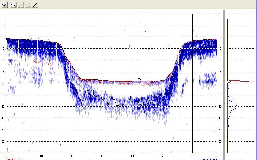
4 Problem Statement Why Is It A Problem? Sounding pole, lead line, and acoustic echo sounding will generally not correlate with one another, or give consistent readings from one time to the next when the same type of instrument is used in fluid mud (Hydro EM). Measurement ambiguity has hindered optimization of Corps management of Gulfport Ship Channel.
5 Source: Kirby and Parker 1978
6 $1,000,000 $181,455
7 Nautical Bottom Definiton PIANC-IAPH 1997: the level where physical characteristics of the bottom reach a critical limit beyond which contact with a ship s keel causes either damage or unacceptable effects on controllability and manoeuvrability Nautical Bottom Approach Requires: practical fluid mud criterion & critical value practical, continuous survey method minimum underkeel clearance value knowledge about ship behaviour


8

9
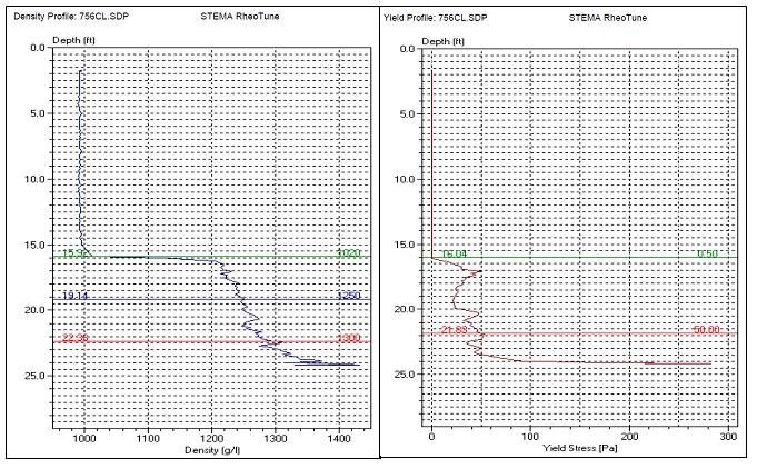
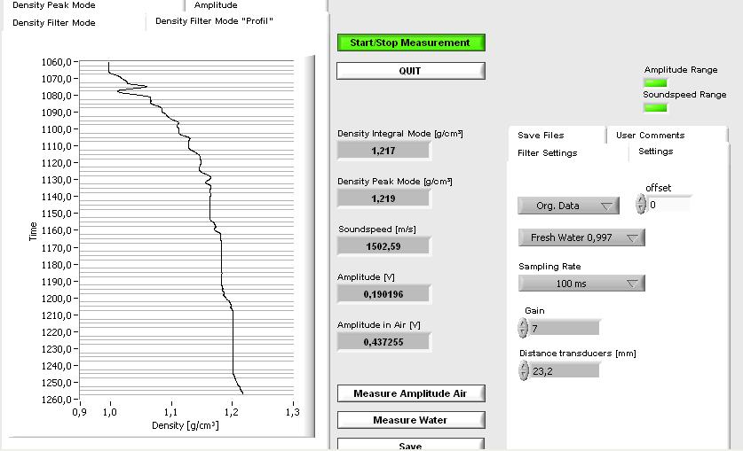
10 Fluid Mud Field Drop Admodus 10A Admodus 10B Admodus 10C BV Rheotune 10 (9/19) Rheotune 10 comp (9/21) SILAS Water/Silt interface SILAS g/ml boundary SILAS g/ml boundary SILAS seafloor CTD 1 (9/19) Depth (ft) Water / Silt Interface khz Depth Density (g/ml)
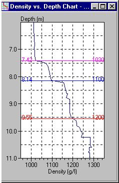
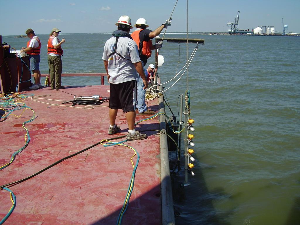
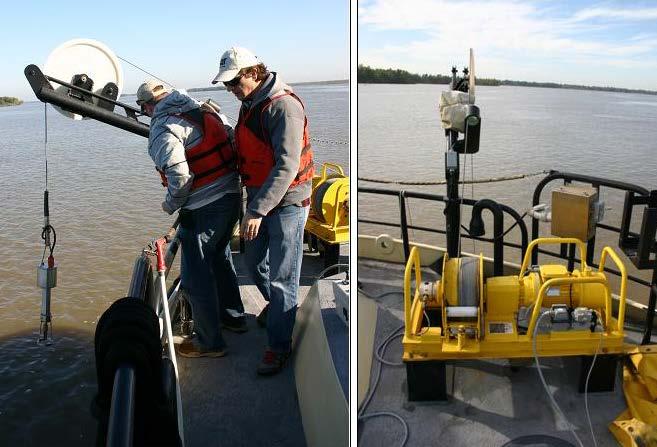
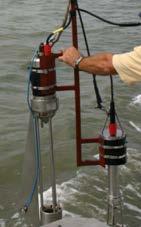
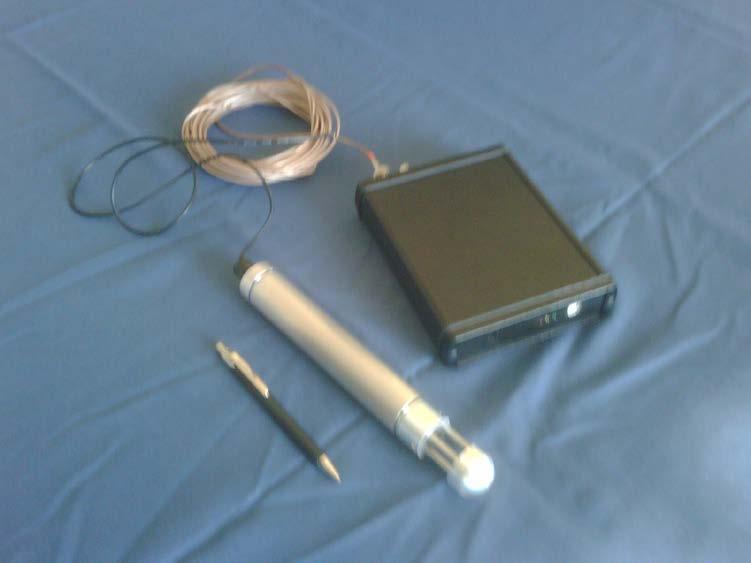
11 Practical Continuous Survey Method Rheotune Density Probe SILAS
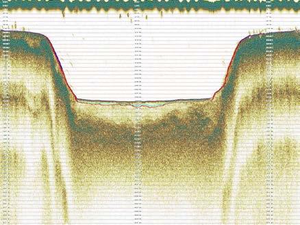
12 Practical Continuous Survey Method SILAS DIGITAL RECORDING LINE 17 LEGEND TOP SILT LAYER 1.200kg\liter DENSITY LEVEL TOP CONSOLIDATED MATERIAL SILAS SURVEY GULF PORT DIGITAL RECORDING OF ODOM ECHOTRACK MK III 24 khz FEQUENCY
13
14 World Wide Nauical Depth Criterion Critical Limits Density (g/cm 3 )

15 Economic Impact Study Results - 800,000 yd 3 /9 months, $2.1M -$5.6M - Estimate that if fluid mud layer excluded could reduce dredging in excess of 250,000 yd 3 - annual savings $550,000 to $1.4M - 50 year project life potential savings $28 to $70M - build acre new CDF $28 -$49M - extend CDF life 10 years


16 SAM Hydro Survey Using SILAS & Rheotune

17 Nautical Bottom Definiton PIANC-IAPH 1997: the level where physical characteristics of the bottom reach a critical limit beyond which contact with a ship s keel causes either damage or unacceptable effects on controllability and manoeuvrability Nautical Bottom Approach Requires: practical fluid mud criterion & critical value practical, continuous survey method minimum underkeel clearance value knowledge about ship behaviour
18 Implementation Plan Upgrade SAM with state-of-practice fluid mud surveying equipment and train personnel on its use to determine where nautical bottom is (1.2 gm/cm 3 horizon). Develop hydrodynamic model for ERDC ship simulator to calculate ship response to the variety of forces (Gulfport-specific environmental and mariner controlled) being exerted upon the vessel w/o fluid mud. Modify ship simulator with Ghent University/Flemish Hydraulics Institute fluid mud/ship maneuverability hydraulic coefficients. Have Gulfport Pilots drive simulator with fluid mud, then with different fluid mud densities and underkeel clearances to accept nautical depth criteria. Monitor dredging to optimize maintenance dredging contract management.

19 Dr. Marc Vantorre EXPERIMENTAL PROGRAM Source: Dr. Marc Vantorre 2005 Towing tank for maneuvers in shallow water co-operation Flanders Hydraulics Laboratory & Belgium Ghent University, Belgium


20 ERDC Ship Simulator Collection & Rendering of Visuals
21 Implementation Plan Upgrade SAM with state-of-practice fluid mud surveying equipment and train personnel on its use to determine where nautical bottom is (1.2 gm/cm 3 horizon). Develop hydrodynamic model for CHL ship simulator to calculate ship response to the variety of forces (Gulfport-specific environmental and mariner controlled) being exerted upon the vessel w/o fluid mud. Modify ship simulator with Ghent University/Flemish Hydraulics Institute fluid mud/ship maneuverability hydraulic coefficients. Have Gulfport Pilots drive simulator with fluid mud, then with different fluid mud densities and underkeel clearances to accept nautical depth criteria. Monitor dredging to optimize maintenance dredging contract management.
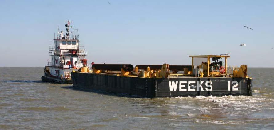

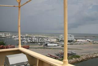
22 Atchafalaya Bar Channel
23 Atchafalaya Bar Channel
24 High Resolution Density Profiler
CORPS IMPLEMENTATION OF NAUTICAL DEPTH IN CHANNELS WITH FLUID MUD
 CORPS IMPLEMENTATION OF NAUTICAL DEPTH IN CHANNELS WITH FLUID MUD Timothy Welp, Dennis Webb and Keith Martin ERDC Steve Reid and Herb Bullock Mobile District Mike Sullivan, Chris Colombo and Andrew Oakman
ERDC/CHL TR Figure 26. Median Grain Size distribution for Matagorda Bay sediment modeling.
 ERDC/CHL TR-13-10 41 Figure 26. Median Grain Size distribution for Matagorda Bay sediment modeling. The cohesive sediment transport algorithm in the CMS explicit model assumes sediment transport occurs
THE DEFINITION OF THE NAUTICAL BOTTOM IN MUDDY NAVIGATIONAL AREAS
 4th MASHCON, Hamburg - Uliczka et al. (eds) - 2016 Bundesanstalt für Wasserbau ISBN 978-3-939230-38-0 (Online) DOI: 10.18451/978-3-939230-38-0_8 THE DEFINITION OF THE NAUTICAL BOTTOM IN MUDDY NAVIGATIONAL
Sediment Management Technologies
 Sediment Management Technologies W. H. McAnally PhD, PE, D.CE, D.NE, F.ASCE Research Professor of Civil & Environmental Engineering Mississippi State University, USA. mcanally@cee.msstate.edu R. Kirby
ASSESSMENT OF SILTATION PROCESSES AND IMPLEMENTATION OF NAUTICAL DEPTH IN THE PORT OF COCHIN, INDIA
 ASSESSMENT OF SILTATION PROCESSES AND IMPLEMENTATION OF NAUTICAL DEPTH IN THE PORT OF COCHIN, INDIA B. Ferket 1, M. Heredia Gomez 1, I. Rocabado 1, R. De Sutter 1, T. Van Hoestenberghe 2, J. Kwee 3, C.
A lithological map created from multibeam backscatter data in challenging circumstances: the Lower Sea Scheldt estuary
 A lithological map created from multibeam backscatter data in challenging circumstances: the Lower Sea Scheldt estuary Mieke Mathys*, Marc Sas*, Frederik Roose** HYDRO12, Rotterdam, 15/11/2012 *International
NOVEL SEDIMENT PROFILER FOR PREPARING AND EVALUATING DREDGING WORKS AND DETERMINING THE NAUTICAL DEPTH
 NOVEL SEDIMENT PROFILER FOR PREPARING AND EVALUATING DREDGING WORKS AND DETERMINING THE NAUTICAL DEPTH By K. Geirnaert 1, P. Staelens 1, S. Deprez 1 B. Dierikx 2, M. van der Sluijs 2, G. Poot 2 ABSTRACT
Re-thinking cohesive sediment dredging management; a combination of fundamental and pragmatic research.
 Re-thinking cohesive sediment dredging management; a combination of fundamental and pragmatic research. Renaat De Sutter, Styn Claeys, Thomas Van Hoestenberghe (Antea group) Toon Verwaest, Joris Vanlede,
OCCURRENCE, BEHAVIOUR AND PHYSICAL
 OCCURRENCE, BEHAVIOUR AND PHYSICAL PROPERTIES OF FLUID MUD Christine Habermann* and Andreas Wurpts** * Federal Institute of Hydrology /Dpt. Groundwater, Geology and River Morphology, Koblenz ** Franzius-Institute
ERDC Update SAD Regional Management Board
 ERDC Update SAD Regional Management Board José E. Sanchez, P.E., SES Director, Coastal and Hydraulics Laboratory Engineer Research and Development Center 14FEB17 Overview of R&D Activities in AOR Cross
Provide end users with the most accurate nautical depth measurement by using the combination of echo sounders and density measurement equipment
 Provide end users with the most accurate nautical depth measurement by using the combination of echo sounders and Pieter J. DE BOER, Coen J. WERNER Keywords: nautical depth, fluid mud, acoustic density
Material Workshop. Galveston District 2012 Beneficial Use of Dredged. Material Workshop. Custodians of the Coast
 Galveston District 2012 Beneficial Use of Dredged Material Workshop Galveston District 2012 Beneficial Use of Dredged Material Workshop US Army Corps of Engineers BUILDING STRONG Welcome Opening Remarks
MaxDepth Aquatics, Inc.
 MaxDepth Aquatics, Inc. Bathymetry of Mirror Pond From Newport Bridge to Galveston Bridge Prepared for the City of Bend By Joseph Eilers & Benn Eilers MaxDepth Aquatics, Inc. Bend, OR June 2005 INTRODUCTION
SEDIMINTATION CHALLENGES IN UMM QASR PORT, IRAQ
 Paper No: P021 SEDIMINTATION CHALLENGES IN UMM QASR PORT, IRAQ by C. Jürgensen 1, A.A. Samir 2, S. Salim 3, J.B. Abild 4, M. Hassan 5, H.J. Vested 6, L. Dall 7 and N. Arndal 8 ABSTRACT The paper describes
Sediment Management Alternatives for the Port of Gulfport, Mississippi
 Sediment Management Alternatives for the Port of Gulfport, Mississippi Trey E. Davis and William H. McAnally Civil and Environmental Engineering Department James Worth Bagley College of Engineering Mississippi
June 2018 Sediments and Dredging at GBR Ports
 June 2018 Sediments and Dredging at GBR Ports Reef 2050 Long Term Sustainability Plan The Great Barrier Reef is over 2000 km long and covers an area of approximately 350,000 square kilometres. It is a
Appendix I. Dredged Volume Estimates. Draft Contractor Document: Subject to Continuing Agency Review
 Appendix I Dredged Volume Estimates Draft Contractor Document: Subject to Continuing Agency Review Interoffice Correspondence Date: April 6, 2007 To: L. Bossi (WHI) Copy: S. Thompson (WHI), B. Fidler (NNJ)
Paper 114 Validation of Actual Depth Measurements by Inland Vessels
 Paper 114 Validation of Actual Depth Measurements by Inland Vessels VAN DER MARK C.F. 1 ; VIJVERBERG T. 2 ; OTTEVANGER W. 1 1 Deltares, Delft, the Netherlands 2 Royal HaskoningDHV, Amersfoort, the Netherlands
PIANC. Salinity and Locks. 1. Salinity and nautical aspects 2. Salinity and the environment 3. Salinity and sedimentation 4. Mitigating measures
 PIANC The World Association for Waterborne Transport Infrastructure International Marine and Dredging Consultants (Belgium) PIANC Workshop 15-16th 16th October 2009 2. Salinity and the environment 3. Salinity
Applying Electrical Resistivity Methods for Measuring Dredged Material Density in Hopper Bins
 DRP-3-07 November 1992 Dredging Technical Research Notes Applying Electrical Resistivity Methods for Measuring Dredged Material Density in Hopper Bins Purpose This technical note provides information on
Redwood City Harbor, California, Navigation Improvement Feasibility Study. Appendix D. Geotechnical Engineering. DRAFT April 2015
 1 Redwood City Harbor, California, Navigation Improvement Feasibility Study Appendix D Geotechnical Engineering DRAFT April 2015 2 Contents 1 Purposes of Report... 3 2 Background... 3 3 References and
Sediment Traps. CAG Meeting May 21, 2012
 Sediment Traps CAG Meeting May 21, 2012 Agenda Background Fundamentals of Sediment Transport Sediment Trap Existing Information Next Steps 2 The Site Saginaw River 22 mile river beginning at confluence
Sediment Dynamics from the Summit to the Sea
 Sediment Dynamics from the Summit to the Sea 435 (Proceedings of a symposium held in New Orleans, Louisiana, USA, 11 14 December 214) (IAHS Publ. 367, 214). Effects of salinity and particle concentration
Engineering with Nature: Nearshore Berm Placements at Fort Myers Beach and Perdido Key, Florida, USA
 Engineering with Nature: Nearshore Berm Placements at Fort Myers Beach and Perdido Key, Florida, USA Katherine E. Brutsché, Ph.D. Research Physical Scientist ERDC-Coastal & Hydraulics Laboratory May 14,
SUBJECT INDEX. ~ ~5 physico-chemical properties 254,255 Redox potential 254,255
 Aggregates: beds formed by deposition 81,82 breakup by fluid shear, introduction 85,86 deposition from flowing water 80 implications in cohesive sediment transport 102-105 needs for further research 83
MISSISSIPPI COASTAL IMPROVEMENTS
 MISSISSIPPI COASTAL IMPROVEMENTS PROGRAM (MsCIP) Comprehensive Barrier 237 27 200 237 27 200 Island 237 Restoration 27 200 Plan 80 9 27 252 74.59 255 255 255 0 0 0 63 63 63 3 32 22 239 65 53 0 35 20 2
Coastal and Hydraulics Laboratory
 ERDC/CHL TR-09-6 Houston-Galveston Navigation Channels, Texas Project Navigation Channel Sedimentation Study, Phase 2 Plan Simulations Jennifer N. Tate and Cassandra G. Ross August 2009 Coastal and Hydraulics
Securing Manoeuverability of a Deep Draft Ship in a Sediment loaded Tidal River Berth
 Securing Manoeuverability of a Deep Draft Ship in a Sediment loaded Tidal River Berth O. Stoschek 1, A. Matheja 1 & C. Zimmermann 1 1 Franzius-Institute for Hydraulic, Waterways and Coastal Engineering,
WG-43 REPORT OBJECTIVES
 HARBORS,SEMINAR NAVIGATION & ENVIRONMENT ENVIRONMENT SEMINAR Minimizing Harbor Working Group 43 John Headland Santiago Alfageme June, 2006 Current Deflecting Wall Hamburg, Germany WG-43 REPORT OBJECTIVES
Proceedings of the ASME 27th International Conference on Offshore Mechanics and Arctic Engineering OMAE2008 June 15-20, 2008, Estoril, Portugal
 Proceedings of the ASME 27th International Conference on Offshore Mechanics and Arctic Engineering OMAE2008 June 15-20, 2008, Estoril, Portugal OMAE2008-57912 SHIP MOTIONS IN SHALLOW WATER AS THE BASE
Monitoring The Sand Extraction On The Belgian Continental Shelf
 Monitoring The Sand Extraction On The Belgian Continental Shelf Methodology, Results And Expectations K. Degrendele and M. Roche Within the framework of a sustainable exploitation of the mineral resources
THE SETTLING OF MUD FLOCS IN THE DOLLARD ESTUARY, THE NETHERLANDS
 THE SETTLING OF MUD FLOCS IN THE DOLLARD ESTUARY, THE NETHERLANDS SUMMARY Chapter 1 Introduction and literature review Morphological changes of estuarine channels and tidal flats depend on erosion, sediment
RECENT SEDIMENTS OF CALIFORNIA PART A. INTRODUCTION AND GRAIN SIZE ANALYSIS HYDRAULIC ENGINEERING LABORATORY COLLEGE OF ENGINEERING C.
 HEL-2-19! 9* I 1 f RECENT SEDIMENTS OF BOLINAS BAY CALIFORNIA PART A. INTRODUCTION AND GRAIN SIZE ANALYSIS by C. ISSELHARDT L. OSUCH RWILDE. HYDRAULIC ENGINEERING LABORATORY COLLEGE OF ENGINEERING UNIVERSITY
Appendix O. Sediment Transport Modelling Technical Memorandum
 Appendix O Sediment Transport Modelling Technical Memorandum w w w. b a i r d. c o m Baird o c e a n s engineering l a k e s design r i v e r s science w a t e r s h e d s construction Final Report Don
Coastal and Hydraulics Laboratory
 SAM Hydraulic Design Package for Channels Coastal and Hydraulics Laboratory William A. Thomas, Ronald R. Copeland, and Dinah N. McComas September 2002 Approved for public release; distribution is unlimited.
SEAFLOOR CHARACTERIZATION BY ELECTROMAGNETIC BENTHIC PROFILING
 SEAFLOOR CHARACTERIZATION BY ELECTROMAGNETIC BENTHIC PROFILING Hendrik Müller Christian Hilgenfeldt Tilo von Dobeneck Benjamin Baasch Thomas Frederichs MARUM Center for Marine Environmental Sciences (University
Inspection of Waterfront Facilities Using Vessel-Based Remote Sensing Mitchell, Del Bello, Suarez
 Inspection of Waterfront Facilities Using Vessel-Based Remote Sensing Mitchell, Del Bello, Suarez American Association of Port Authorities Facilities Engineering Conference October 20-22, 2015 Waterfront
Particle Tracking Model Data Analysis Tools Part 2: Capabilities in SMS
 ERDC TN-DOER-D16 Particle Tracking Model Data Analysis Tools Part 2: Capabilities in SMS by Zeki Demirbilek, Tahirih Lackey, and Alan K. Zundel PURPOSE: A number of new analysis methods and tools have
IN SITU SPECIFIC GRAVITY VS GRAIN SIZE: A BETTER METHOD TO ESTIMATE NEW WORK DREDGING PRODUCTION
 IN SITU SPECIFIC GRAVITY VS GRAIN SIZE: A BETTER METHOD TO ESTIMATE NEW WORK DREDGING PRODUCTION Nancy Case O Bourke, PE 1, Gregory L. Hartman, PE 2 and Paul Fuglevand, PE 3 ABSTRACT In-situ specific gravity
National Marine Sanctuary Program
 National Marine Sanctuary Program NMSP/USGS Joint Seabed Mapping Initiative: September 2004 AA National Ocean Service National Marine Sanctuaries Interim Report September 2004 Background: Since 2002,
MUDMAP TM. Software Description
 ASA Applied Science Associates, Inc. 70 Dean Knauss Drive Narragansett, RI 02882-1143 U.S.A. Tel: 401-789-6224 Fax: 401-789-1932 asa@asascience.com www.asascience.com MUDMAP TM Software Description MUDMAP
THIN-LAYER PLACEMENT OF DREDGE MATERIAL FOR MARSH NOURISHMENT, RESOTRATION, AND RESPONSE TO SEA LEVEL RISE
 THIN-LAYER PLACEMENT OF DREDGE MATERIAL FOR MARSH NOURISHMENT, RESOTRATION, AND RESPONSE TO SEA LEVEL RISE Case studies and lesson learned regarding thin-layer deposition projects in Delaware, New Jersey,
Annual transport rates at two locations on the fore-slope.
 Sediment Transport by Currents Fore-slope Sediment transport rates and sediment concentrations were computed from the hydrodynamic model runs as well as from direct measurements of current velocities at
Mooring Model for Barge Tows in Lock Chamber
 Mooring Model for Barge Tows in Lock Chamber by Richard L. Stockstill BACKGROUND: Extensive research has been conducted in the area of modeling mooring systems in sea environments where the forcing function
Appendix G.19 Hatch Report Pacific NorthWest LNG Lelu Island LNG Maintenance Dredging at the Materials Offloading Facility
 Appendix G.19 Hatch Report Pacific NorthWest LNG Lelu Island LNG Maintenance Dredging at the Materials Offloading Facility Project Memo H345670 To: Capt. David Kyle From: O. Sayao/L. Absalonsen December
Sediment Management Alternatives for the Port of Bienville
 Sediment Management Alternatives for the Port of Bienville Jeremy A. Sharp, Hunter N. Johnson, Kimberly C. Pevey, and William H. McAnally Civil and Environmental Engineering Department James Worth Bagley
CHARTING A DYNAMIC SEAFLOOR:
 CHARTING A DYNAMIC SEAFLOOR: how an excellent survey becomes a poor data set, and what to tell the mariner INTRODUCTION Hydrographic offices that chart a seafloor with dynamic behaviour are faced with
Bishopville Prong Study
 Bathymetric and Sediment Assessment in the Bishopville Prong of St. Martin River Darlene V. Wells, Richard A. Ortt, Jr., and Stephen Van Ryswick Funded by MCBP 2011-2012 Implementation Grant Objectives
Island Design. UMRS EMP Regional Workshop. Presentation for the
 Island Design Presentation for the UMRS EMP Regional Workshop by Jon Hendrickson Hydraulic Engineer Regional Technical Specialist, Water Quality and Habitat Restoration August 17 19, 2005 Project Delivery
COASTAL PLANNING & ENGINEERING OF NORTH CAROLINA, INC
 4038 MASONBORO LOOP ROAD, WILMINGTON, NC 28409 910-791-9494 PHONE 910-791-4129 FAX July 15, 2014 David W. Cooke Regional Supervisor for Resource Evaluation Bureau of Ocean Energy Management Gulf of Mexico
U.S. Army Corps of Engineers Detroit District. Sediment Trap Assessment Saginaw River, Michigan
 U.S. Army Corps of Engineers Detroit District December 2001 December 2001 This report has been prepared for USACE, Detroit District by: W.F. BAIRD & ASSOCIATES LTD. 2981 YARMOUTH GREENWAY MADISON, WISCONSIN
Analysis of Environmental Impacts from the Port of Miami Expansion. Julienne Beblo
 Analysis of Environmental Impacts from the Port of Miami Expansion Julienne Beblo 6.28.16 The Port of Miami One of the most prominent ports for global tourism and commerce Contributes $28 billion/yr to
VOYAGE (PASSAGE) PLANNING
 PLANNING") VOYAGE (PASSAGE) PLANNING Introduction O Passage planning or voyage planning is a procedure of developing a complete description of a vessel's voyage from start to finish. O Production of a passage plan
VOYAGE (PASSAGE) PLANNING Introduction O Passage planning or voyage planning is a procedure of developing a complete description of a vessel's voyage from start to finish. O Production of a passage plan
Technical Memorandum
 2855 Telegraph Avenue, Suite 4, Berkeley, CA 9475, Phone (51) 848-898, Fax (51) 848-8398 Technical Memorandum Date: September 6, 27 To: Mr. Michael Bowen, Project Manager From: Yantao Cui, Ph.D., Hydraulic
WATER INJECTION DREDGING by L.C. van Rijn
 WATER INJECTION DREDGING by L.C. van Rijn (info@leovanrijn-sediment.com) Description of method Almost all harbour basins suffer from the problem of siltation of sediments. Usually, the deposited materials
PTM: A Lagrangian Particle Tracking Model. Joseph Gailani
 PTM: A Lagrangian Particle Tracking Model Joseph Gailani Joe.Z.Gailani@usace.army.mil OUTLINE Motivation for sediment/constituent modeling system Objectives of modeling system Description of PTM PTM Example
Introduction to Acoustic Remote Sensing and Seafloor Mapping (AE4-E13) May 19, 2010
 May 19, 2010") Introduction to Acoustic Remote Sensing and Seafloor Mapping (AE4-E13) May 19, 2010 1 Delft Vermelding Institute onderdeel of Earth organisatie Observation and Space Systems Why Acoustic Remote Sensing?
Introduction to Acoustic Remote Sensing and Seafloor Mapping (AE4-E13) May 19, 2010 1 Delft Vermelding Institute onderdeel of Earth organisatie Observation and Space Systems Why Acoustic Remote Sensing?
Long-Distance Pumping and Opportunities for Engineering with Nature
 Long-Distance Pumping and Opportunities for Engineering with Nature Tim Welp and Derek Wilson Tim Welp Research Hydraulic Engineer Coastal and Hydraulics Laboratory 23 October 2012 Engineering with Nature
Sediment Resuspension by Dredges: Defining the Issues
 Sediment Resuspension by Dredges: Defining the Issues Doug Clarke Environmental Laboratory U.S. Army Corps of Engineers Engineer Research and Development Center Dredge types Definition Related processes
Combining SES and ADCP to measure mud transport processes in tide-controlled estuaries
 7 th Workshop Seabed Acoustics, Rostock, November 19/20, 2015 P06-1 Combining SES and ADCP to measure mud transport processes in tide-controlled estuaries Dr. Marius Becker Centre for Marine Sciences (MARUM),
MIKE 21 & MIKE 3 Flow Model FM. Mud Transport Module. Short Description
 MIKE 21 & MIKE 3 Flow Model FM Mud Transport Module Short Description DHI headquarters Agern Allé 5 DK-2970 Hørsholm Denmark +45 4516 9200 Telephone +45 4516 9333 Support +45 4516 9292 Telefax mike@dhigroup.com
MEMORANDUM. Scott Pickard, CELRB-TD-EH Michael Asquith, CELRB-PM-PM. From: Paul R. Schroeder, Ph.D., PE Earl Hayter, Ph.D. Date: 14 March 2016
 DEPARTMENT OF THE ARMY ENGINEER RESEARCH AND DEVELOPMENT CENTER, CORPS OF ENGINEERS ENVIRONMENTAL LABORATORY WATERWAYS EXPERIMENT STATION, 3909 HALLS FERRY ROAD VICKSBURG, MISSISSIPPI 39180-6199 29 November
Subcommittee on Sedimentation Draft Sediment Analysis Guidelines for Dam Removal
 Subcommittee on Sedimentation Draft Sediment Analysis Guidelines for Dam Removal August 4, 2011 Jennifer Bountry, M.S., P.E. Tim Randle, M.S., P.E., D.WRE. Blair Greimann, Ph.D., P.E. Sedimentation and
PG&E OFFSHORE CENTRAL COASTAL CALIFORNIA SEISMIC IMAGING PROJECT
 PG&E OFFSHORE CENTRAL COASTAL CALIFORNIA SEISMIC IMAGING PROJECT Public Scoping Meeting California State Lands Commission July 21, 2011 Project Area Project Commitments Assessment of the Hosgri, Shoreline,
7.0 Project Reports 7.1 Geophysical Mapping of Submarine Environments
 7.0 Project Reports 7.1 Geophysical Mapping of Submarine Environments Suzanne Carbotte, Robin Bell, Roger Flood 7.1.1 METHODS In April 2000 we deployed the R/V Onrust, operated by MSRC at SUNY Stony Brook,
SEDIMENT TRANSPORT IN RIVER MOUTH ESTUARY
 SEDIMENT TRANSPORT IN RIVER MOUTH ESTUARY Katsuhide YOKOYAMA, Dr.Eng. dredge Assistant Professor Department of Civil Engineering Tokyo Metropolitan University 1-1 Minami-Osawa Osawa, Hachioji,, Tokyo,
B-1. Attachment B-1. Evaluation of AdH Model Simplifications in Conowingo Reservoir Sediment Transport Modeling
 Attachment B-1 Evaluation of AdH Model Simplifications in Conowingo Reservoir Sediment Transport Modeling 1 October 2012 Lower Susquehanna River Watershed Assessment Evaluation of AdH Model Simplifications
NAME: GEL 109 Final Winter 2010
 GEL 109 Final Winter 2010 1. The following stratigraphic sections represents a single event followed by the slow accumulation of background sedimentation of shale. Describe the flows that produced the
MORPHODYNAMIC PROCESSES IN ESTUARIES COMPARISON OF MARINE AND LIMNIC TIDAL FLATS
 MORPHODYNAMIC PROCESSES IN ESTUARIES COMPARISON OF MARINE AND LIMNIC TIDAL FLATS Thorsten Albers 1, Dagmar Much 2, Nino Ohle 2, Nicole von Lieberman 1, Eva Falke 1 Tidal flat areas in estuaries are affected
Estimated Sediment Volume: Bridge Street Dam Impoundment, Royal River, Yarmouth, Maine
 University of Southern Maine USM Digital Commons Publications Casco Bay Estuary Partnership (CBEP) 2015 Estimated Sediment Volume: Bridge Street Dam Impoundment, Royal River, Yarmouth, Maine Stantec Follow
FINAL REPORT Fluid Mud in Energetic Systems: FLUMES II
 DISTRIBUTION STATEMENT A. Approved for public release; distribution is unlimited. FINAL REPORT Fluid Mud in Energetic Systems: FLUMES II Gail C. Kineke Dept of Earth and Environmental Sciences Devlin Building
Port of Kalama, 2013 TEMCO Berth Maintenance Dredging and In-water Flow-Lane Placement Project
 2014 WEDA ENVIRONMENTAL EXCELLENCE AWARDS Category: Navigation Dredging Port of Kalama, 2013 TEMCO Berth Maintenance Dredging and In-water Flow-Lane Placement Project Port of Kalama, Washington 18 April
Dredging and environment : MARCOM contributions
 Dredging and environment : MARCOM contributions by Mr Geoffroy CAUDE Chairman of MARCOM General Delegate of Union des ports de France (french ports association) Dredging and environment : MARCOM contributions
2. Identify other PIs associated with the cruise: 3. Identify the at-sea Chief Scientist: Charles Langmuir
 Pre-Cruise Meeting April 17, 2014 AT26-19, Charles Langmuir, Aug 28 Sept 11, 2014. RV Atlantis with OSU Coring Facility General Program Overview: 1. Scientific Objectives: Our aim is to obtain as many
MARITIME UNIVERSITY IN SZCZECIN ORGANIZATIONAL UNIT: FACULTY OF NAVIGATION - DEPARTMENT OF NAVIGATION DEVICES. Instruction
 MARITIME UNIVERSITY IN SZCZECIN ORGANIZATIONAL UNIT: FACULTY OF NAVIGATION - DEPARTMENT OF NAVIGATION DEVICES Instruction 1 PRINCIPLE OF OPERATION AND HANDLING OF SPEED LOG Lab Prepared by M. Przywarty,
Coastal Zone Mapping and Imaging Lidar (CZMIL)
") Coastal Zone Mapping (CZMIL) Shallow Survey 2012 Wellington, New Zealand Christopher L. Macon U.S. Army Corps of Engineers, Mobile District Joint Airborne Lidar Bathymetry Technical Center of expertise
Coastal Zone Mapping (CZMIL) Shallow Survey 2012 Wellington, New Zealand Christopher L. Macon U.S. Army Corps of Engineers, Mobile District Joint Airborne Lidar Bathymetry Technical Center of expertise
GSA DATA REPOSITORY
 GSA DATA REPOSITORY 2009206 Miner et al. Supplemental Material Bathymetric Survey Methods The bathymetric data for the area were gathered using a single-beam bathymetric survey rig mounted aboard a 21-foot
Coastal and Hydraulics Laboratory
 ERDC/CHL TR-11-5 Vertical Ship Motion Study for Savannah, GA Entrance Channel Michael J. Briggs and William G. Henderson September 2011 Coastal and Hydraulics Laboratory Approved for public release; distribution
Evaluation of Potential for Sedimentation on Natural Oyster Bar 8-11 from Dike Construction at the Poplar Island Environmental Restoration Project
 Department of Natural Resources Resource Assessment Service MARYLAND GEOLOGICAL SURVEY Emery T. Cleaves, Director COASTAL AND ESTUARINE GEOLOGY FILE REPORT NO. 02-05 Evaluation of Potential for Sedimentation
Side Scan Sonar Results for Additional Hardbottom Habitat Identification in Charleston Entrance Channel
 U.S. Army Corps of Engineers Charleston District APPENDIX H CHARLESTON HARBOR POST 45 BENEFICIAL USE OF DREDGED MATERIAL SUPPLEMENTAL ENVIRIONMENTAL ASSESSMENT CHARLESTON, SOUTH CAROLINA Side Scan Sonar
Variability in Geotechnical Properties of Sediments and Dredged Materials
 Variability in Geotechnical Properties of Sediments and Dredged Materials PURPOSE: This technical note provides an overview of selected uncertainties involved in estimating or characterizing pre-dredged
Seagrass Transplantation & Environmental & Marine Consulting Services, Inc. Drew Campbell, Vice President & Lead Scientst.
 Indian River Lagoon Symposium Seagrass Transplantation & Project Considerations Environmental & Marine Consulting Services, Inc. Drew Campbell, Vice President & Lead Scientst March 26 th, 2013 Regulatory
TECHNICAL MEMO: FAR-FIELD SURVEYS OF SUSPENDED SEDIMENT PLUMES ASSOCIATED WITH CUTTERHEAD DREDGING IN JONES INLET, LONG ISLAND, NEW YORK
 TECHNICAL MEMO: FAR-FIELD SURVEYS OF SUSPENDED SEDIMENT PLUMES ASSOCIATED WITH CUTTERHEAD DREDGING IN JONES INLET, LONG ISLAND, NEW YORK Federal Navigation Project FINAL Prepared for U.S. Army Corps of
Acoustical recognition of the bottom sediments in the southern Baltic Sea
 Acoustical recognition of the bottom sediments in the southern Baltic Sea PACS: 43.30.Ma Jaros³aw Têgowski Institute of Oceanology, Polish Academy of Sciences, Powstañców Warszawy 55,8-7 Sopot, Poland,
Acoustic seafloor mapping systems. September 14, 2010
 Acoustic seafloor mapping systems September 14, 010 1 Delft Vermelding Institute onderdeel of Earth organisatie Observation and Space Systems Acoustic seafloor mapping techniques Single-beam echosounder
FINMARINET: Inventories and Planning for the Marine Natura 2000 Network in Finland. A.2 Geological inventories of the seafloor Final Report
 LIFE07 NAT/FIN/000151 FINMARINET: Inventories and Planning for the Marine Natura 2000 Network in Finland A.2 Geological inventories of the seafloor Final Report Geological Survey of Finland, GTK 1. Introduction
Themes for Geomatics Conference. Geodesy Themes
 Themes for Geomatics Conference Geodesy Themes Geodynamics o Modeling the Deformation of the Earth s Crust o Recent Advances in Geometric Approaches to Deformation Analysis o Monitoring Systems (Sensors
Ultrasonic Measuring System for Deposition of Sediments in Reservoirs
 MECAHITECH 11, vol. 3, year: 011 Ultrasonic Measuring System for Deposition of Sediments in Reservoirs M. Mărgăritescu* 1, A. Moldovanu * 1, P. Boeriu *, A.M.E. Rolea* 1 * 1 National Institute of Research
A novel methodology for the calibration of discrete settling behaviour of activated sludge
 A novel methodology for the calibration of discrete settling behaviour of activated sludge E. Torfs*, F. Mahdavi Mazdeh*, G. Bellandi* and I. Nopens* * BIOMATH, Department of Mathematical Modelling, Statistics
J. Bio. & Env. Sci. 2014
 Journal of Biodiversity and Environmental Sciences (JBES) ISSN: 2220-6663 (Print) 2222-3045 (Online) Vol. 5, No. 5, p. 75-81, 2014 http://www.innspub.net RESEARCH PAPER OPEN ACCESS Investigation on the
Submerged Oil Recovery Systems and Recommendations. RDC Kurt Hansen Regional Response Team 5 Minneapolis, MN April 30, 2014
 Submerged Oil Recovery Systems and Recommendations RDC Kurt Hansen Regional Response Team 5 Minneapolis, MN April 30, 2014 Outline Submerged Oil Background Past R&D Related Efforts Project at USCG RDC
Acoustic wave reflection from the transition layer of surficial marine sediment
 Acoust. Sci. & Tech. 25, 3 (2004) PAPER Acoustic wave reflection from the transition layer of surficial marine sediment Masao Kimura and Takuya Tsurumi School of Marine Science and Technology, Tokai University
Current Hydrographic Projects at BSH
 7 th Workshop Seabed Acoustics, Rostock, November 19/20, 2015 P01-1 Current Hydrographic Projects at BSH Thomas Dehling Federal Maritime and Hydrographic Agency (BSH) Germany Contact Address Website BSH
Estimating vertical and horizontal resistivity of the overburden and the reservoir for the Alvheim Boa field. Folke Engelmark* and Johan Mattsson, PGS
 Estimating vertical and horizontal resistivity of the overburden and the reservoir for the Alvheim Boa field. Folke Engelmark* and Johan Mattsson, PGS Summary Towed streamer EM data was acquired in October
DEPARTMENT OF CHEMICAL ENGINEERING University of Engineering & Technology, Lahore. Fluid Mechanics Lab
 DEPARTMENT OF CHEMICAL ENGINEERING University of Engineering & Technology, Lahore Fluid Mechanics Lab Introduction Fluid Mechanics laboratory provides a hands on environment that is crucial for developing
ADH Sediment Module Testing
 ADH Sediment Module Testing By Jennifer N. Tate and R. C. Berger PURPOSE: The Kate Aubrey reach of the Mississippi River, located north of Memphis, TN, was used as a test domain for the ADaptive Hydraulics
STUDY PERFORMANCE REPORT
 STUDY PERFORMANCE REPORT State: Michigan Project No.: F-80-R-8 Study No.: 230702 Title: Effects of sediment traps on Michigan river channels Period Covered: October 1, 2006 to September 30, 2007 Study
THEORY: SETTLING PROCESSES
 INTRODUCTION MANY METHODS OF MECHANICAL SEPARATION ARE BASED ON THE MOVEMENT OF THE SOLID PARTICLES OR LIQUID DROPS THROUGH A FLUID. IN THIS TOPIC WE ARE FOCUSING ON SOME SITUATIONS OF THE PARTICLES DELIBERATELY
INNOVATIVE TECHNIQUES TO INVESTIGATE CONTAMINATION IN FRACTURED BEDROCK
 INNOVATIVE TECHNIQUES TO INVESTIGATE CONTAMINATION IN FRACTURED BEDROCK Abstract Christopher Gaule 1, Kenneth Goldstein 2, Grant Anderson 3 Watervliet Arsenal, located in Watervliet, New York, is the oldest