CORPS IMPLEMENTATION OF NAUTICAL DEPTH IN CHANNELS WITH FLUID MUD
|
|
|
- Everett Jenkins
- 5 years ago
- Views:
Transcription


1 CORPS IMPLEMENTATION OF NAUTICAL DEPTH IN CHANNELS WITH FLUID MUD Timothy Welp, Dennis Webb and Keith Martin ERDC Steve Reid and Herb Bullock Mobile District Mike Sullivan, Chris Colombo and Andrew Oakman New Orleans District
2 Outline What is fluid mud? Fluid mud hydro surveying considerations What is nautical bottom/depth and what s needed to implement? Corps past/present/future implementation activities
3 Definition of Fluid Mud Fluid mud is a high concentration aqueous suspension of fine-grained sediment in which settling is substantially hindered by the proximity of sediment grains and flocs, but which has not formed an inter-connected matrix of bonds strong enough to eliminate the potential for mobility, leading to a persistent suspension. McAnally et al. 2007


4 What is Fluid Mud?

5
6 Source: Kirby and Parker

7 Fluid Mud Mobility Tidal currents and river flows can move the upper portions of the fluid mud around. Deep draft vessel pressure wave and propeller wash can also move/modify fluid mud.

8 Problem Statement Why Is It A Problem? Sounding pole, lead line, and acoustic echo sounding will generally not correlate with one another, or give consistent readings from one time to the next when the same type of instrument is used in fluid mud (Hydro EM). Measurement ambiguity has hindered optimization of Corps management of channels with fluid mud.
9 Source: Kirby and Parker 1978


10 $1,000,000 $180,000
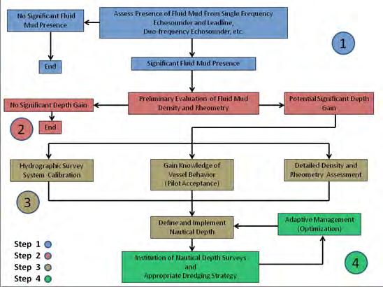
11 Nautical Bottom Definiton PIANC-IAPH 1997: the level where physical characteristics of the bottom reach a critical limit beyond which contact with a ship s keel causes either damage or unacceptable effects on controllability and manoeuvrability Nautical Bottom Approach Requires: practical fluid mud criterion & critical value practical, continuous survey method minimum underkeel clearance value knowledge about ship behaviour
12 Practical Fluid Mud Criterion & Critical Value Density
13 Practical Fluid Mud Criterion & Critical Value Yield Stress

14 Gulfport Ship Channel Calcasieu Bar Channel Atchafalaya Bar Channel

15 Practical Continuous Survey Method Gulfport Ship Channel, Mississippi


16 Practical Continuous Survey Method Densitune Density Probe SILAS
17 Practical Continuous Survey Method SILAS DIGITAL RECORDING LINE 17 LEGEND TOP SILT LAYER 1.200kg\liter DENSITY LEVEL TOP CONSOLIDATED MATERIAL SILAS SURVEY GULF PORT DIGITAL RECORDING OF ODOM ECHOTRACK MK III 24 khz FEQUENCY


18
19 Fluid Mud Field Drop Admodus 10A Admodus 10B Admodus 10C BV Rheotune 10 (9/19) Rheotune 10 comp (9/21) SILAS Water/Silt interface SILAS g/ml boundary SILAS g/ml boundary SILAS seafloor CTD 1 (9/19) Depth (ft) Water / Silt Interface khz Depth Density (g/ml)


20 Atchafalaya (Louisiana) Bar Channel


21 Vicksburg Mississippi Densitune Testing

22 Vicksburg Mississippi Densitune Testing Depth Above Bottom Ball Valve Sample Density Densitune Density Relative Difference % 40 cm cm cm cm


23 New Orleans District Hydro Survey Rheotune & SILAS Rheotune Port of Morgan City


24 MVN Hydro Survey SILAS & Rheotune 1.2 g/cm 3 horizon SILAS


25 Mobile District Hydro Survey SILAS & Rheotune

26 Nautical Bottom Definiton PIANC-IAPH 1997: the level where physical characteristics of the bottom reach a critical limit beyond which contact with a ship s keel causes either damage or unacceptable effects on controllability and manoeuvrability Nautical Bottom Approach Requires: practical fluid mud criterion & critical value practical, continuous survey method minimum underkeel clearance value knowledge about ship behaviour
27 Knowledge of Ship Behavior Observe ship behavior relative to density/yield stress horizons Develop Calcasieu Bar Channel hydrodynamic model for ERDC ship simulator w/o fluid mud effects. Modify ship simulator with Ghent University/Flemish Hydraulics Institute fluid mud/ship maneuverability hydraulic coefficients. Have Calcasieu Pilots drive simulator with differing fluid mud conditions. Achieve a common understanding of nautical depth.
28 Calcasieu Bar Channel Speed Reductions Reported by Bar Pilots Depth (ft) Lutocline and Nautical Depth Station Number Date Draft (ft) Reduction (knots) 10/16/ /18/ /18/ /26/ /1/ /4/ /5/ /12/ /9/ Average Average of 35 + draft Jan-11 Lut. Jan-11 ND Jun-11 Lut. Jun-11 ND Several vessels over 35 in draft showed a consistent reduction in speed with constant RPM from buoys

29 Source: Dr. Marc Vantorre 2005 Dr. Marc Vantorre Towing tank for maneuvers in shallow water co-operation Flanders Hydraulics Laboratory & Belgium Ghent University, Belgium
30 ERDC Ship Simulator


31 Emden Germany Sediment Conditioning


32 Atchafalaya Bar Channel Bed-leveler (Modified) Sediment Conditioning Demo


33 Atchafalaya Bar Channel Sediment Conditioning Demo

34 Corps Nautical Depth Implementation Hydrographic Surveying Engineer Manual


35 Corps Nautical Depth Implementation Hydrographic Surveying Engineer Manual
36
37 Corps Nautical Depth Implementation Engineering Technical Letter? Engineering Regulation?

38 Questions?
U.S. Army Corps of Engineers Investigation on the Implementation of Nautical Depth
 U.S. Army Corps of Engineers Investigation on the Implementation of Nautical Depth Tim Welp, Steve Reid, and Dennis Webb Tim Welp Research Hydraulic Engineer ERDC Coastal and Hydraulics Laboratory 25 October
Sediment Management Technologies
 Sediment Management Technologies W. H. McAnally PhD, PE, D.CE, D.NE, F.ASCE Research Professor of Civil & Environmental Engineering Mississippi State University, USA. mcanally@cee.msstate.edu R. Kirby
ASSESSMENT OF SILTATION PROCESSES AND IMPLEMENTATION OF NAUTICAL DEPTH IN THE PORT OF COCHIN, INDIA
 ASSESSMENT OF SILTATION PROCESSES AND IMPLEMENTATION OF NAUTICAL DEPTH IN THE PORT OF COCHIN, INDIA B. Ferket 1, M. Heredia Gomez 1, I. Rocabado 1, R. De Sutter 1, T. Van Hoestenberghe 2, J. Kwee 3, C.
THE DEFINITION OF THE NAUTICAL BOTTOM IN MUDDY NAVIGATIONAL AREAS
 4th MASHCON, Hamburg - Uliczka et al. (eds) - 2016 Bundesanstalt für Wasserbau ISBN 978-3-939230-38-0 (Online) DOI: 10.18451/978-3-939230-38-0_8 THE DEFINITION OF THE NAUTICAL BOTTOM IN MUDDY NAVIGATIONAL
ERDC/CHL TR Figure 26. Median Grain Size distribution for Matagorda Bay sediment modeling.
 ERDC/CHL TR-13-10 41 Figure 26. Median Grain Size distribution for Matagorda Bay sediment modeling. The cohesive sediment transport algorithm in the CMS explicit model assumes sediment transport occurs
A lithological map created from multibeam backscatter data in challenging circumstances: the Lower Sea Scheldt estuary
 A lithological map created from multibeam backscatter data in challenging circumstances: the Lower Sea Scheldt estuary Mieke Mathys*, Marc Sas*, Frederik Roose** HYDRO12, Rotterdam, 15/11/2012 *International
SUBJECT INDEX. ~ ~5 physico-chemical properties 254,255 Redox potential 254,255
 Aggregates: beds formed by deposition 81,82 breakup by fluid shear, introduction 85,86 deposition from flowing water 80 implications in cohesive sediment transport 102-105 needs for further research 83
Re-thinking cohesive sediment dredging management; a combination of fundamental and pragmatic research.
 Re-thinking cohesive sediment dredging management; a combination of fundamental and pragmatic research. Renaat De Sutter, Styn Claeys, Thomas Van Hoestenberghe (Antea group) Toon Verwaest, Joris Vanlede,
OCCURRENCE, BEHAVIOUR AND PHYSICAL
 OCCURRENCE, BEHAVIOUR AND PHYSICAL PROPERTIES OF FLUID MUD Christine Habermann* and Andreas Wurpts** * Federal Institute of Hydrology /Dpt. Groundwater, Geology and River Morphology, Koblenz ** Franzius-Institute
Provide end users with the most accurate nautical depth measurement by using the combination of echo sounders and density measurement equipment
 Provide end users with the most accurate nautical depth measurement by using the combination of echo sounders and Pieter J. DE BOER, Coen J. WERNER Keywords: nautical depth, fluid mud, acoustic density
Sediment Management Alternatives for the Port of Gulfport, Mississippi
 Sediment Management Alternatives for the Port of Gulfport, Mississippi Trey E. Davis and William H. McAnally Civil and Environmental Engineering Department James Worth Bagley College of Engineering Mississippi
U.S. Army Corps of Engineers Detroit District. Sediment Trap Assessment Saginaw River, Michigan
 U.S. Army Corps of Engineers Detroit District December 2001 December 2001 This report has been prepared for USACE, Detroit District by: W.F. BAIRD & ASSOCIATES LTD. 2981 YARMOUTH GREENWAY MADISON, WISCONSIN
Sediment Dynamics from the Summit to the Sea
 Sediment Dynamics from the Summit to the Sea 435 (Proceedings of a symposium held in New Orleans, Louisiana, USA, 11 14 December 214) (IAHS Publ. 367, 214). Effects of salinity and particle concentration
Securing Manoeuverability of a Deep Draft Ship in a Sediment loaded Tidal River Berth
 Securing Manoeuverability of a Deep Draft Ship in a Sediment loaded Tidal River Berth O. Stoschek 1, A. Matheja 1 & C. Zimmermann 1 1 Franzius-Institute for Hydraulic, Waterways and Coastal Engineering,
PTM: A Lagrangian Particle Tracking Model. Joseph Gailani
 PTM: A Lagrangian Particle Tracking Model Joseph Gailani Joe.Z.Gailani@usace.army.mil OUTLINE Motivation for sediment/constituent modeling system Objectives of modeling system Description of PTM PTM Example
Development, Testing and Application of the Multi-Block LTFATE Hydrodynamic and Sediment Transport Model
 Development, Testing and Application of the Multi-Block LTFATE Hydrodynamic and Sediment Transport Model Earl Hayter Environmental Lab October 25, 2012 LTFATE Multi-Block Hydrodynamic, Water Quality and
Measurements of lateral flow from the Mississippi River at Mardi Gras Pass in the Bohemia Spillway using synoptic ADCP
 Measurements of lateral flow from the Mississippi River at Mardi Gras Pass in the Bohemia Spillway using synoptic ADCP A Technical Report Submitted to: The Lake Pontchartrain Basin Foundation Submitted
Appendix I. Dredged Volume Estimates. Draft Contractor Document: Subject to Continuing Agency Review
 Appendix I Dredged Volume Estimates Draft Contractor Document: Subject to Continuing Agency Review Interoffice Correspondence Date: April 6, 2007 To: L. Bossi (WHI) Copy: S. Thompson (WHI), B. Fidler (NNJ)
Coastal and Hydraulics Laboratory
 ERDC/CHL TR-09-6 Houston-Galveston Navigation Channels, Texas Project Navigation Channel Sedimentation Study, Phase 2 Plan Simulations Jennifer N. Tate and Cassandra G. Ross August 2009 Coastal and Hydraulics
Bishopville Prong Study
 Bathymetric and Sediment Assessment in the Bishopville Prong of St. Martin River Darlene V. Wells, Richard A. Ortt, Jr., and Stephen Van Ryswick Funded by MCBP 2011-2012 Implementation Grant Objectives
Applying Electrical Resistivity Methods for Measuring Dredged Material Density in Hopper Bins
 DRP-3-07 November 1992 Dredging Technical Research Notes Applying Electrical Resistivity Methods for Measuring Dredged Material Density in Hopper Bins Purpose This technical note provides information on
NOVEL SEDIMENT PROFILER FOR PREPARING AND EVALUATING DREDGING WORKS AND DETERMINING THE NAUTICAL DEPTH
 NOVEL SEDIMENT PROFILER FOR PREPARING AND EVALUATING DREDGING WORKS AND DETERMINING THE NAUTICAL DEPTH By K. Geirnaert 1, P. Staelens 1, S. Deprez 1 B. Dierikx 2, M. van der Sluijs 2, G. Poot 2 ABSTRACT
PART 5 MECHANISMS OF GROUND SETTLEMENT IN GREATER NEW ORLEANS
 PART 5 MECHANISMS OF GROUND SETTLEMENT IN GREATER NEW ORLEANS Predicted water depth in New Orleans flood inundation area based on water level of 2.37 ft in Lake Ponchartrain on Sept 2, 2005. Overlay on
Sediment Traps. CAG Meeting May 21, 2012
 Sediment Traps CAG Meeting May 21, 2012 Agenda Background Fundamentals of Sediment Transport Sediment Trap Existing Information Next Steps 2 The Site Saginaw River 22 mile river beginning at confluence
MaxDepth Aquatics, Inc.
 MaxDepth Aquatics, Inc. Bathymetry of Mirror Pond From Newport Bridge to Galveston Bridge Prepared for the City of Bend By Joseph Eilers & Benn Eilers MaxDepth Aquatics, Inc. Bend, OR June 2005 INTRODUCTION
SEAFLOOR CHARACTERIZATION BY ELECTROMAGNETIC BENTHIC PROFILING
 SEAFLOOR CHARACTERIZATION BY ELECTROMAGNETIC BENTHIC PROFILING Hendrik Müller Christian Hilgenfeldt Tilo von Dobeneck Benjamin Baasch Thomas Frederichs MARUM Center for Marine Environmental Sciences (University
Water flowing in the stream can move sediments along the stream channel because of an exchange of energy from the
 1. Base your answer(s) to the following question(s) on the Earth Science Reference Tables, the diagram below, and your knowledge of Earth science. The diagram represents a laboratory stream table. Water
Combining SES and ADCP to measure mud transport processes in tide-controlled estuaries
 7 th Workshop Seabed Acoustics, Rostock, November 19/20, 2015 P06-1 Combining SES and ADCP to measure mud transport processes in tide-controlled estuaries Dr. Marius Becker Centre for Marine Sciences (MARUM),
WG-43 REPORT OBJECTIVES
 HARBORS,SEMINAR NAVIGATION & ENVIRONMENT ENVIRONMENT SEMINAR Minimizing Harbor Working Group 43 John Headland Santiago Alfageme June, 2006 Current Deflecting Wall Hamburg, Germany WG-43 REPORT OBJECTIVES
Material Workshop. Galveston District 2012 Beneficial Use of Dredged. Material Workshop. Custodians of the Coast
 Galveston District 2012 Beneficial Use of Dredged Material Workshop Galveston District 2012 Beneficial Use of Dredged Material Workshop US Army Corps of Engineers BUILDING STRONG Welcome Opening Remarks
B-1. Attachment B-1. Evaluation of AdH Model Simplifications in Conowingo Reservoir Sediment Transport Modeling
 Attachment B-1 Evaluation of AdH Model Simplifications in Conowingo Reservoir Sediment Transport Modeling 1 October 2012 Lower Susquehanna River Watershed Assessment Evaluation of AdH Model Simplifications
Proceedings of the ASME 27th International Conference on Offshore Mechanics and Arctic Engineering OMAE2008 June 15-20, 2008, Estoril, Portugal
 Proceedings of the ASME 27th International Conference on Offshore Mechanics and Arctic Engineering OMAE2008 June 15-20, 2008, Estoril, Portugal OMAE2008-57912 SHIP MOTIONS IN SHALLOW WATER AS THE BASE
THE IMPORTANCE OF SCIENCE IN COASTAL RESTORATION IN LOUISIANA
 THE IMPORTANCE OF SCIENCE IN COASTAL RESTORATION IN LOUISIANA Barb Kleiss USACE, Mississippi Valley Division August 3, 2011 LCA S&T Office Authorized under WRDA 2007 Designed to address technical issues
MEMORANDUM. Scott Pickard, CELRB-TD-EH Michael Asquith, CELRB-PM-PM. From: Paul R. Schroeder, Ph.D., PE Earl Hayter, Ph.D. Date: 14 March 2016
 DEPARTMENT OF THE ARMY ENGINEER RESEARCH AND DEVELOPMENT CENTER, CORPS OF ENGINEERS ENVIRONMENTAL LABORATORY WATERWAYS EXPERIMENT STATION, 3909 HALLS FERRY ROAD VICKSBURG, MISSISSIPPI 39180-6199 29 November
Anderson-Ketron PSDDA Disposal Site Fate and Transport Modeling
 Pierce County Washington Anderson-Ketron PSDDA Disposal Site Fate and Transport Modeling Design Memorandum September 2014 Table of Contents 1 Introduction... 3 1.1 Purpose and Scope... 3 1.2 Project Description:
Enhanced Characterization of the Mississippi River Valley Alluvial Aquifer Using Surface Geophysical Methods
 Photo by Shane Stocks, U.S. Geological Survey Enhanced Characterization of the Mississippi River Valley Alluvial Aquifer Using Surface Geophysical Methods Presented by Ryan F. Adams US Geological Survey
SEDIMINTATION CHALLENGES IN UMM QASR PORT, IRAQ
 Paper No: P021 SEDIMINTATION CHALLENGES IN UMM QASR PORT, IRAQ by C. Jürgensen 1, A.A. Samir 2, S. Salim 3, J.B. Abild 4, M. Hassan 5, H.J. Vested 6, L. Dall 7 and N. Arndal 8 ABSTRACT The paper describes
Appendix G.19 Hatch Report Pacific NorthWest LNG Lelu Island LNG Maintenance Dredging at the Materials Offloading Facility
 Appendix G.19 Hatch Report Pacific NorthWest LNG Lelu Island LNG Maintenance Dredging at the Materials Offloading Facility Project Memo H345670 To: Capt. David Kyle From: O. Sayao/L. Absalonsen December
Sediment Management Alternatives for the Port of Bienville
 Sediment Management Alternatives for the Port of Bienville Jeremy A. Sharp, Hunter N. Johnson, Kimberly C. Pevey, and William H. McAnally Civil and Environmental Engineering Department James Worth Bagley
Applying Gerris to Mixing and Sedimentation in Estuaries
 Applying Gerris to Mixing and Sedimentation in Estuaries Timothy R. Keen U.S. Naval Research Laboratory Stennis Space Center, Mississippi, U.S.A. 4 July 2011 Université Pierre et Marie Curie Paris, France
Coastal and Hydraulics Laboratory
 ERDC/CHL TR-05-6 Texas City Ship Channel Deepening Study, Hydrodynamic Model Lisa M. Lee, Jennifer N. Tate, and R. C. Berger August 2005 Coastal and Hydraulics Laboratory Approved for public release; distribution
ADH Sediment Module Testing
 ADH Sediment Module Testing By Jennifer N. Tate and R. C. Berger PURPOSE: The Kate Aubrey reach of the Mississippi River, located north of Memphis, TN, was used as a test domain for the ADaptive Hydraulics
THE SETTLING OF MUD FLOCS IN THE DOLLARD ESTUARY, THE NETHERLANDS
 THE SETTLING OF MUD FLOCS IN THE DOLLARD ESTUARY, THE NETHERLANDS SUMMARY Chapter 1 Introduction and literature review Morphological changes of estuarine channels and tidal flats depend on erosion, sediment
Redwood City Harbor, California, Navigation Improvement Feasibility Study. Appendix D. Geotechnical Engineering. DRAFT April 2015
 1 Redwood City Harbor, California, Navigation Improvement Feasibility Study Appendix D Geotechnical Engineering DRAFT April 2015 2 Contents 1 Purposes of Report... 3 2 Background... 3 3 References and
Paper 114 Validation of Actual Depth Measurements by Inland Vessels
 Paper 114 Validation of Actual Depth Measurements by Inland Vessels VAN DER MARK C.F. 1 ; VIJVERBERG T. 2 ; OTTEVANGER W. 1 1 Deltares, Delft, the Netherlands 2 Royal HaskoningDHV, Amersfoort, the Netherlands
7.0 Project Reports 7.1 Geophysical Mapping of Submarine Environments
 7.0 Project Reports 7.1 Geophysical Mapping of Submarine Environments Suzanne Carbotte, Robin Bell, Roger Flood 7.1.1 METHODS In April 2000 we deployed the R/V Onrust, operated by MSRC at SUNY Stony Brook,
PRESENTATION TITLE. Regional Sediment Management Application of a Coastal Model at the St. Johns River Entrance BUILDING STRONG
 PRESENTATION TITLE Regional Sediment Management Application of a Coastal Model at the St. Johns River Entrance Steven Bratos Senior Coastal Engineer U.S. Army Corps of Engineers Jacksonville District February
J. Bio. & Env. Sci. 2014
 Journal of Biodiversity and Environmental Sciences (JBES) ISSN: 2220-6663 (Print) 2222-3045 (Online) Vol. 5, No. 5, p. 75-81, 2014 http://www.innspub.net RESEARCH PAPER OPEN ACCESS Investigation on the
Mississippi River West Bay Diversion Geomorphic Assessment and 1-D Modeling Plan
 Mississippi River West Bay Diversion Geomorphic Assessment and 1-D Modeling Plan Freddie Pinkard and Charlie Little Research Hydraulic Engineers ERDC-CHL-River Engineering Branch 27 February 2009 Lane
ERDC Update SAD Regional Management Board
 ERDC Update SAD Regional Management Board José E. Sanchez, P.E., SES Director, Coastal and Hydraulics Laboratory Engineer Research and Development Center 14FEB17 Overview of R&D Activities in AOR Cross
Modeling Nearshore Waves for Hurricane Katrina
 Modeling Nearshore Waves for Hurricane Katrina Jane McKee Smith US Army Engineer Research & Development Center Coastal and Hydraulics Laboratory Outline Introduction Modeling Approach Hurricane Katrina
SECTION 5 EDI Cartridge Valves
 SECTION Cartridge Valves Make Model Page Way Pilot Operated Poppet Style Way Pilot Operated Double Lock Way Direct cting 3 Way -Position Direct cting 4 Way -Position Direct cting Spool Style 4 Way 3-Position
Coastal and Hydraulics Laboratory
 SAM Hydraulic Design Package for Channels Coastal and Hydraulics Laboratory William A. Thomas, Ronald R. Copeland, and Dinah N. McComas September 2002 Approved for public release; distribution is unlimited.
Forecast of Nearshore Wave Parameters Using MIKE-21 Spectral Wave Model
 Forecast of Nearshore Wave Parameters Using MIKE-21 Spectral Wave Model Felix Jose 1 and Gregory W. Stone 2 1 Coastal Studies Institute, Louisiana State University, Baton Rouge, LA 70803 2 Coastal Studies
Analysis of Physical Oceanographic Data from Bonne Bay, September 2002 September 2004
 Physics and Physical Oceanography Data Report -1 Analysis of Physical Oceanographic Data from Bonne Bay, September September Clark Richards and Brad deyoung Nov. 9 Department of Physics and Physical Oceanography
Sediment Transport Analysis for Stream Restoration Design: The Good, the Bad, and the Ugly.
 Sediment Transport Analysis for Stream Restoration Design: The Good, the Bad, and the Ugly. Brett Jordan Phd, PE HydroGeo Designs LLC. Land and Water Services Inc. THE GOOD THE BAD THE UGLY THE GOOD THE
Acoustic seafloor mapping systems. September 14, 2010
 Acoustic seafloor mapping systems September 14, 010 1 Delft Vermelding Institute onderdeel of Earth organisatie Observation and Space Systems Acoustic seafloor mapping techniques Single-beam echosounder
NAME: GEL 109 Final Winter 2010
 GEL 109 Final Winter 2010 1. The following stratigraphic sections represents a single event followed by the slow accumulation of background sedimentation of shale. Describe the flows that produced the
Annual transport rates at two locations on the fore-slope.
 Sediment Transport by Currents Fore-slope Sediment transport rates and sediment concentrations were computed from the hydrodynamic model runs as well as from direct measurements of current velocities at
Highland Lake Bathymetric Survey
 Highland Lake Bathymetric Survey Final Report, Prepared For: The Town of Highland Lake 612 Lakeshore Drive Oneonta, AL 35121 Prepared By: Tetra Tech 2110 Powers Ferry Road SE Suite 202 Atlanta, GA 30339
Unchain the River and Allow it to Build a Delta
 Unchain the River and Allow it to Build a Delta Harley S. Winer Atkins Harley.Winer@atkinsglobal.com Mississippi River Drainage Basin Basin Facts Drains 41% of continental U.S. Includes 31 states & 2 Canadian
Sediment Flux and Trapping on the Skagit Tidal Flats
 Sediment Flux and Trapping on the Skagit Tidal Flats W. Rockwell Geyer Woods Hole Oceanographic Institution MS 11, Woods Hole, MA 02543 phone: 508-289-2868 fax: 508-457-2194 email: rgeyer@whoi.edu Peter
TECHNICAL MEMO: FAR-FIELD SURVEYS OF SUSPENDED SEDIMENT PLUMES ASSOCIATED WITH CUTTERHEAD DREDGING IN JONES INLET, LONG ISLAND, NEW YORK
 TECHNICAL MEMO: FAR-FIELD SURVEYS OF SUSPENDED SEDIMENT PLUMES ASSOCIATED WITH CUTTERHEAD DREDGING IN JONES INLET, LONG ISLAND, NEW YORK Federal Navigation Project FINAL Prepared for U.S. Army Corps of
Reactivation of Klingnau reservoir sidearm: Numerical simulation of sediment release downstream
 River Flow 2014 Schleiss et al. (Eds) 2014 Taylor & Francis Group, London, ISBN 978-1-138-02674-2 Reactivation of Klingnau reservoir sidearm: Numerical simulation of sediment release downstream A. Amini
COASTAL PLANNING & ENGINEERING OF NORTH CAROLINA, INC
 4038 MASONBORO LOOP ROAD, WILMINGTON, NC 28409 910-791-9494 PHONE 910-791-4129 FAX July 15, 2014 David W. Cooke Regional Supervisor for Resource Evaluation Bureau of Ocean Energy Management Gulf of Mexico
HIGH RESOLUTION SEDIMENT DYNAMICS IN SALT-WEDGE ESTUARIES
 HIGH RESOLUTION SEDIMENT DYNAMICS IN SALT-WEDGE ESTUARIES Philip Orton, Dept. of Environmental Science and Engineering, Oregon Graduate Institute Douglas Wilson, Dept. of Environmental Science and Engineering,
SEDIMENT TRANSPORT IN RIVER MOUTH ESTUARY
 SEDIMENT TRANSPORT IN RIVER MOUTH ESTUARY Katsuhide YOKOYAMA, Dr.Eng. dredge Assistant Professor Department of Civil Engineering Tokyo Metropolitan University 1-1 Minami-Osawa Osawa, Hachioji,, Tokyo,
Ultrasonic Measuring System for Deposition of Sediments in Reservoirs
 MECAHITECH 11, vol. 3, year: 011 Ultrasonic Measuring System for Deposition of Sediments in Reservoirs M. Mărgăritescu* 1, A. Moldovanu * 1, P. Boeriu *, A.M.E. Rolea* 1 * 1 National Institute of Research
Decline of Lake Michigan-Huron Levels Caused by Erosion of the St. Clair River
 Decline of Lake Michigan-Huron Levels Caused by Erosion of the St. Clair River W.F. & Associates Coastal Engineers (in association with Frank Quinn) April 13, 2005 Outline Problem Definition Understanding
Particle Tracking Model Data Analysis Tools Part 2: Capabilities in SMS
 ERDC TN-DOER-D16 Particle Tracking Model Data Analysis Tools Part 2: Capabilities in SMS by Zeki Demirbilek, Tahirih Lackey, and Alan K. Zundel PURPOSE: A number of new analysis methods and tools have
FINAL REPORT Fluid Mud in Energetic Systems: FLUMES II
 DISTRIBUTION STATEMENT A. Approved for public release; distribution is unlimited. FINAL REPORT Fluid Mud in Energetic Systems: FLUMES II Gail C. Kineke Dept of Earth and Environmental Sciences Devlin Building
Coastal and Hydraulics Laboratory
 ERDC/CHL TR-11-5 Vertical Ship Motion Study for Savannah, GA Entrance Channel Michael J. Briggs and William G. Henderson September 2011 Coastal and Hydraulics Laboratory Approved for public release; distribution
Clearing the Mississippi Coast, Locating Post Hurricane Katrina Marine Debris
 Joseph Burke (primary author and intended presenter) Project Manager NOAA Division, C&C Technologies, Inc. 730 East Kaliste Saloom Rd., Lafayette LA, USA 70508 Phone: 337-261-0660, E-mail: Joseph.Burke@cctechnol.com
WATER INJECTION DREDGING by L.C. van Rijn
 WATER INJECTION DREDGING by L.C. van Rijn (info@leovanrijn-sediment.com) Description of method Almost all harbour basins suffer from the problem of siltation of sediments. Usually, the deposited materials
Development and application of demonstration MIKE 21C morphological model for a bend in Mekong River
 Development and application of demonstration MIKE 21C morphological model for a bend in Mekong River September 2015 0 Table of Contents 1. Introduction... 2 2. Data collection... 3 2.1 Additional data...
Investigation on Dynamics of Sediment and Water Flow in a Sand Trap
 Investigation on Dynamics of Sediment and Water Flow in a Sand Trap M. R. Mustafa Department of Civil Engineering Universiti Teknologi Petronas 31750 Tronoh, Perak, Malaysia R. B. Rezaur Water Resources
A STUDY OF LOCAL SCOUR AT BRIDGE PIERS OF EL-MINIA
 A STUDY OF LOCAL SCOUR AT BRIDGE PIERS OF EL-MINIA Dr. Gamal A. Sallam 1 and Dr. Medhat Aziz 2 ABSTRACT Bridges are critical structures that require a substantial investment to construct and serve an important
Coastal and Hydraulics Laboratory
 ERDC/CHL TR-15-12 Numerical Sedimentation Study of Shoaling on the Ohio River near Mound City, Illinois David Abraham, PhD., P.E., Nate Clifton, and Barry Vessels August 2015 Coastal and Hydraulics Laboratory
Field and Numerical Study of the Columbia River Mouth
 DISTRIBUTION STATEMENT A. Approved for public release; distribution is unlimited. Field and Numerical Study of the Columbia River Mouth Guy Gelfenbaum 400 Natural Bridges Dr. Santa Cruz, CA 95060 Phone:
Webinar on PTM with CMS
 Webinar on PTM with CMS Honghai Li Research Physical Scientist Mitchell E. Brown Civil Engineering Technician Engineer Research and Development Center CMS December 4, 2013 US Army Corps of Engineers BUILDING
Main issues of Deltas
 Global sediment supply to coastal seas and oceans; location of major river deltas RIVER DELTAS Depositional processes - Course Coastal Morphodynamics GEO3-436; lecture 4 Nile Delta, Egypt Solo Delta, Java,
RECENT SEDIMENTS OF CALIFORNIA PART A. INTRODUCTION AND GRAIN SIZE ANALYSIS HYDRAULIC ENGINEERING LABORATORY COLLEGE OF ENGINEERING C.
 HEL-2-19! 9* I 1 f RECENT SEDIMENTS OF BOLINAS BAY CALIFORNIA PART A. INTRODUCTION AND GRAIN SIZE ANALYSIS by C. ISSELHARDT L. OSUCH RWILDE. HYDRAULIC ENGINEERING LABORATORY COLLEGE OF ENGINEERING UNIVERSITY
Computing the Joint Probability of Hurricane Sandy and Historical Coastal Storm Forcing Parameters from Maine to Virginia
 Computing the Joint Probability of Hurricane Sandy and Historical Coastal Storm Forcing Parameters from Maine to Virginia Chris Massey and Jeff Melby USACE-ERDC Coastal & Hydraulics Lab Chris.Massey@usace.army.mil
L.O: SLOWING STREAMS DEPOSIT (SORT) SEDIMENT HORIZONTALLY BY SIZE.
 SEDIMENT HORIZONTALLY BY SIZE.") L.O: SLOWING STREAMS DEPOSIT (SORT) SEDIMENT HORIZONTALLY BY SIZE. 1. Base your answer to the following question on the profile shown below, which shows the pattern of horizontal sorting produced at a
L.O: SLOWING STREAMS DEPOSIT (SORT) SEDIMENT HORIZONTALLY BY SIZE. 1. Base your answer to the following question on the profile shown below, which shows the pattern of horizontal sorting produced at a
Hydraulic Processes Analysis System (HyPAS)
") Hydraulic Processes Analysis System (HyPAS) by Thad C. Pratt and Daryl S. Cook PURPOSE: This Coastal Engineering Technical Note (CETN) describes a PC-Windows-based system for analyzing, visualizing, and
Hydraulic Processes Analysis System (HyPAS) by Thad C. Pratt and Daryl S. Cook PURPOSE: This Coastal Engineering Technical Note (CETN) describes a PC-Windows-based system for analyzing, visualizing, and
HEC-RAS Reservoir Transport Simulation of Three Reservoirs in the Lower Susquehanna River Basin. Mike Langland and Ed Koerkle
 HEC-RAS Reservoir Transport Simulation of Three Reservoirs in the Lower Susquehanna River Basin Mike Langland and Ed Koerkle Topics Background / Project Objectives Data Selection - Sediment and Geometric
River bed classification using multi-beam echo-sounder backscatter data
 River bed classification using multi-beam echo-sounder backscatter data Niels Kinneging Mirjam Snellen Dimitrios Eleftherakis Dick Simons Erik Mosselman Arjan Sieben 13 November 2012 transport water management
Available online at ScienceDirect. Procedia Engineering 154 (2016 )
") Available online at www.sciencedirect.com ScienceDirect Procedia Engineering 154 (2016 ) 574 581 12th International Conference on Hydroinformatics, HIC 2016 Research on the Strength and Space-time Distribution
Available online at www.sciencedirect.com ScienceDirect Procedia Engineering 154 (2016 ) 574 581 12th International Conference on Hydroinformatics, HIC 2016 Research on the Strength and Space-time Distribution
Mooring Model for Barge Tows in Lock Chamber
 Mooring Model for Barge Tows in Lock Chamber by Richard L. Stockstill BACKGROUND: Extensive research has been conducted in the area of modeling mooring systems in sea environments where the forcing function
Groundwater dynamics and surface water-groundwater interaction in a prograding delta island, Louisiana, USA
 Supplementary Information Groundwater dynamics and surface water-groundwater interaction in a prograding delta island, Louisiana, USA Michael T. O Connor 1* and Kevan B. Moffett 1,2 1 Department of Geological
DEPARTMENT OF THE ARMY WATERWAYS EXPERIMENT STATION. CORPS OF ENGINEERS P. 0. BOX 631 VICKSBURG. MISSISSIPPI 39180
 DEPARTMENT OF THE ARMY WATERWAYS EXPERIMENT STATION. CORPS OF ENGINEERS P. 0. BOX 631 VICKSBURG. MISSISSIPPI 39180 IN REPLY REF6R TO: WESYV 31 July 1978 SUBJECT: Transmittal of Technical Report D-78-34
Dynamics of the Ems Estuary
 Dynamics of the Ems Estuary Physics of coastal systems Jerker Menninga 0439738 Utrecht University Institute for Marine and Atmospheric research Utrecht Lecturer: Prof. dr. H.E. de Swart Abstract During
PROBABILISTIC DESIGN METHOD OF LEVEE AND FLOODWALL HEIGHTS FOR THE HURRICANE PROTECTION SYSTEM IN THE NEW ORLEANS AREA
 PROBABILISTIC DESIGN METHOD OF LEVEE AND FLOODWALL HEIGHTS FOR THE HURRICANE PROTECTION SYSTEM IN THE NEW ORLEANS AREA Mathijs van Ledden Haskoning Inc., 1 Galleria Blvd., Metairie, LA70001, United States,
Coastal and Hydraulics Laboratory
 ERDC/CHL TR-09-13 Port Isabel (GIWW) Channel Improvements at the Queen Isabella Causeway Laguna Madre, Texas, Navigation Improvement Project Timothy W. Shelton, P.E. and Dennis Webb, P.E. September 2009
Bed-load measurements on large, sand-bed rivers in the United States
 Bed-load measurements on large, sand-bed rivers in the United States David Abraham 1,*, Tate McAlpin 1, and Keaton Jones 1 1 US Army Corps of Engineers, Coastal and Hydraulics Laboratory, Vicksburg MS,
VICTORIA BEND HYDRAULIC SEDIMENT RESPONSE MODEL INVESTIGATION LOWER MISSISSIPPI RIVER MILES
 Technical Report M48 VICTORIA BEND HYDRAULIC SEDIMENT RESPONSE MODEL INVESTIGATION LOWER MISSISSIPPI RIVER MILES 600-590 By Peter M. Russell, P.E. Jasen L. Brown, P.E Edward J. Brauer, P.E. Robert D. Davinroy,
Technical Memorandum
 2855 Telegraph Avenue, Suite 4, Berkeley, CA 9475, Phone (51) 848-898, Fax (51) 848-8398 Technical Memorandum Date: September 6, 27 To: Mr. Michael Bowen, Project Manager From: Yantao Cui, Ph.D., Hydraulic
Current Hydrographic Projects at BSH
 7 th Workshop Seabed Acoustics, Rostock, November 19/20, 2015 P01-1 Current Hydrographic Projects at BSH Thomas Dehling Federal Maritime and Hydrographic Agency (BSH) Germany Contact Address Website BSH
Lu, S., P. Craig, C. Wallen, Z. Liu, A. Stoddard, W. McAnnally and E. Maak. Dynamic Solutions, Knoxville, TN USACOE, Sacramento District
 An Extended-Delta Hydrodynamic Model Framework for Sea Level Rise Analysis to Support Resource Management Planning for the Sacramento-San Joaquin River Delta Lu, S., P. Craig, C. Wallen, Z. Liu, A. Stoddard,