Ministry of Minerals Geological Research Authority of Sudan (GRAS)
|
|
|
- Marcia Flynn
- 6 years ago
- Views:
Transcription
 Sudan By: El Gizouli Ahmed Hamid.")
1 ﺑﺴﻢ اﷲ اﻟﺮﺣﻤﻦ اﻟﺮﺣﯿﻢ Ministry of Minerals Geological Research Authority of Sudan (GRAS) Bentonite Deposits of Omm Ali Area (River Nile State) Sudan By: El Gizouli Ahmed Hamid. February 2011
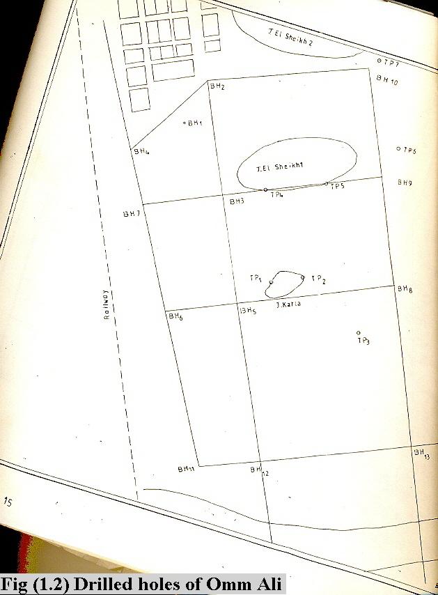
2 Abstract The study area is 0.775km 2, (774.99m 2 ). 15 bore holes were drilled to 11.3m for each in semi-grid system using augering method. 52 samples from different boreholes and depths were collected. The collected samples were tested for Atterburg limits, grain-size distribution, and chemically analyzed for main oxides. There are two layers of clays; the upper is grey in color, and the lower one is dark in color. Grain-size distribution ranges for both clays are shown in table below: Grain size Grey clay Dark clay Sand range 2-28% 3-21% Silt range 12 53% 22-60% Clay range 25-78% % Limits of dark and grey clays of Omm Ali area. Grey clay Dark clay Shrinkage limit 11-28%, 19-28%. Liquid limit 35-75% 51-78%. Plastic limit 13-27% 18-29%. Plasticity index %, 32-54%. Clay activity According to grain size distribution, the raw material either sandy clay of low plasticity, or clay of very high plasticity. The raw material is treated by carboxyl methyl cellulose (C.M.C), the optimum properties obtained at 2%. It is noticed that the dark clay gives good properties than the grey one, to reach the standard values it is recommended that the sand percentage must be decreased, and to be ground finer. Now bentonite comes to Sudan from abroad; estimation of the bentonite reserve of Omm Ali area is m 3. Omm Ali is 298km north from Khartoum. 1
3 1.1 Location: the study area is located on the right bank of the river Nile, between the railway, and the main national road (Khartoum - Atbara). The area is bounded by coordinates 17 o 01 / 26.5 // N, 33 o 43 / 21.1 // E. 17 o 01 / 41.2 // N, 33 o 43 / 42.5 // E. 17 o 00 / 57.9 // N, 33 o 43 / 56.6 // E. 17 o 01 / 05.5 // N, 33 o 43 / 56.6//E. Fig (1). 1.2 Topography: Omm Ali area is pounded by low hills in north, the whole area is gently slopes towards the Nile course. 1.3 Accessibility: The area can be easily reached by both railway and national tarmac road from Khartoum (298km), or from Atbara (90km). 1.4 Climate: It is hot during summer (40 o C), with rare rainfall, and cold during the winter (15 o C). 2
4 Geology The geology of the study area is Cretaceous sediments (Nubian Formation). These strata are defined by Whiteman (1971) as Shendi Formation, which deposited by fluvial and lacostrine. Shendi Formation belongs to Nubian cycle which is Late Jurassic Late Cretaceous in age. The formation is composed of interbedded fluvial and near shore facies in north-west Sudan, Klitzsch and Squyres (1990). These sediments are described as predominant of relatively fine grained clastic of braided meandering, and meandering river, floodplain and minor lacostrine environments Bussert (1993). The Paleoclimate during the deposition of Albian- Cenomanian period have been interpreted as tropical with dry seasons. According to all previous works, kaolinitic and smectitic deposits are part of sedimentary fining upward sequence. On the other hand smectite-mudstone represents lacostrine environment. Hence the smectitic clay is strongly related to warm and humid climate. 3
.")
.")
5 Field and laboratory works Field work: 15 boreholes were drilled in the area in semi grid system. The interval among boreholes varies from 170m to 500m. The total drilled depth is 152.8m, the average depth is 10.18m, all boreholes contain clay except borehole 11 (Fig 1.4). There are two layers of clay, the first one is a grey one, it exposed at the surface, but the other one is not less than 4m deep. These two layers are separated by undesirable layers, (Fig1.3). The reserve estimation is m3. 59 samples were collected from different boreholes and depths. The clay is dominant at the centre of the study area, Fig (1.4). The grey clay is of intermediate plasticity, and almost underlain by dark clay or intercalated with it, Fig (1.3), and (1.4). At the eastern part of the study area the dark clay becomes deeper (8m), Fig (1.3) 4
6 5
 section")


7 Fig (1.3) section through BH 4, 2 and 10 Fig (1.4) section through BH 6, 7 and 11 6
8 Laboratory work: the raw material was chemically analyzed, and the following tests were carried out: grainsize distribution, consistency, limits, plasticity, density, viscosity, gel strength, filterate loss, mud cake, sand content, and PH value detected. The dark clay is high to very high plasticity; it contains less SiO 2, K, Ca, and L.O. I (loss on ignition), but the grey one shows relatively high content of Al 2 O 3, Na, and Fe, table (3). Table (4) shows correlation between Omm Ali clay and international clays. Table (1) Grain size distribution Type of clay Average of grain size Gravel % Sand % Silt % Clay % Classification Grey clay Clay of intermediate plasticity Dark clay Clay of high plasticity. Table (2) Atterburge and clay activity Clay type Atterburge Limit Clay L.L% P.L% P.I% S.L% activity Grey dark Table (3) Average oxides and elements of grey and dark clay Clay Classification Average percentage of main elements SiO 2 Al 2 O 3 Na % K % Ca % Fe % L.O.I % Dark clay High to very high plasticity Grey clay Intermediate plasticity
9 Table (4) Correlation between Omm Ali Clay and International Specification Sample Main oxides % SiO 2 Al 2 O 3 Na 2 O K 2 O CaO Fe 2 O Bentonite blue grey spur bed, Bell Fourche, S.D. Foster (1953). 2. Bentonite, chambers, Ariz, cheto (Kerr et al 1950). 3. Omm Ali dark clay. 4. Omm Ali grey clay. Treatment: Two samples of grey and dark clays each were grinded. Two samples (grey and dark) were treated by carboxyl methyl cellulose (CMC) 2%; the two other samples were tested without treatment. It is noticed that the treated samples improved their properties, and the dark clay shows more good properties, see table (5), Fig (4.4), and Fig (4.5). Table (5) Properties of natural and treated clay. Properties Untreated sample Treated Sample recommended Values (API) Grey Dark Grey Dark Mud density Lb/gal Viscosity Second/quart (march funnel) Gel strength a/ initial lbs/100/ft2 b/after 10 minutes lbs/100ft2 10 Filterate loss c.c API miniuts) Mud cake mm Sand content % P.H value (litmus paper)
10 Fig (4.4) untreated and treated dark and grey clay dark clay grey clay density viscosity gel stren mud cake Fig (4.5) treated clays of Omm Ali and standard values dark clay grey clay stan val mud dens viscosity gel streng mud cake filter loss The table below shows imported bentonite through customs authority, whereas all bentonite for oil companies do not pass through it, so that it is not included here. Table (6) Quantity and values of bentonite imported through customs in period ( ). Year Quantity in tons Values in US$
11 REFERENCES 1. Abdellatif O. M. (1997). Lacostrine Deposits and Fluvial of the Upper Cretaceous, Omm Ali area. Central Sudan. 2. Whiteman A. J. (1971). The Geology of Sudan republic, Oxford Claredon University press. 3. Klitzsch, E. and Squyres, C. H. (1990). Paleozoic and Mesozoic geological history of northeastern Africa based upon new interpretation of Nubian strata: - Amer Ass. Petr. Geol. Bull. 74, , Tulsa. 4. Cassangrade (1977), Method of test for soil for civil engineering purposes; British Standards Institution. 5. Deposits of the Central and Western Gulf of the Mexico Coastal plain, U.S. Geological Survey Bull c. U.S.A. 6. Bussert, R. Brasse, H. Radic, T, and Reynold, P, O. (1990), Sedimentary and Structural Style of a ruft structure in northern Sudan: The Humar Basin: - Berliner geowiss, Abh (A), 120.1, , Berlin. 7. Sudan Customs Authority. 10
Online International Interdisciplinary Research Journal, {Bi-Monthly}, ISSN , Volume-IV, May 2014 Special Issue
 An improving Rheological Properties and Filter Loss of Water-Base Drilling Fluids Using Carboxymethyle Cellulose (CMC) Abusabah.E.Elemam a, Rashid.A.M.Hussien b, Ahmed.A.Ibrahim b, Sumya.A.Mohamed ba College
=%REPORT RECONNAISSANCE OF CHISHOLM LAKE PROSPECT. October 25, 1977
 =%REPORT ON FIELD RECONNAISSANCE OF CHISHOLM LAKE PROSPECT October 25, 1977 Bruce D. Vincent Imperial Oil Limited, Minerals - Coal, CALGARY, ALBERTA CHISHOLM LAKE PROSPECT Introduction The Chisholm Lake
NAME: GEL 109 Final Study Guide - Winter 2008 Questions 6-24 WILL be on the final exactly as written here; this is 60% of the test.
 GEL 109 Final Study Guide - Winter 2008 Questions 6-24 WILL be on the final exactly as written here; this is 60% of the test. 1. Sketch a map view of three types of deltas showing the differences in river,
Lab 7: Sedimentary Structures
 Name: Lab 7: Sedimentary Structures Sedimentary rocks account for a negligibly small fraction of Earth s mass, yet they are commonly encountered because the processes that form them are ubiquitous in the
Assessment of the Effect of Increasing Local Bentonite Concentration on Drilling Fluids Rheology and Filtration Properties
 Assessment of the Effect of Increasing Local Bentonite Concentration on Drilling Fluids Rheology and Filtration Properties Rashid.A.M.Hussein 1, Abusabah.E.Elemam 2, Sumya.A.Mohamed 1, Ahmed.A.Ibrahim
NAME: GEL 109 Final Winter 2010
 GEL 109 Final Winter 2010 1. The following stratigraphic sections represents a single event followed by the slow accumulation of background sedimentation of shale. Describe the flows that produced the
Daniel Koning, Peggy Johnson, and John Hawley. New Mexico Bureau of Geology and Mineral Resources
 Daniel Koning, Peggy Johnson, and John Hawley Daniel Koning 1, Gary Smith 2, and Adam Read 1 1 New Mexico Bureau of Geology and Mineral Resources 2 University of New Mexico Santa Fe Group Definition (Spiegel
4. Soil Consistency (Plasticity) (Das, chapter 4)
 (Das, chapter 4)") 4. Soil Consistency (Plasticity) (Das, chapter 4) 1 What is Consistency? Consistency is a term used to describe the degree of firmness of fine-grained soils (silt and clay). The consistency of fine grained
4. Soil Consistency (Plasticity) (Das, chapter 4) 1 What is Consistency? Consistency is a term used to describe the degree of firmness of fine-grained soils (silt and clay). The consistency of fine grained
GeoCanada 2010 Working with the Earth
 Lithofacies Identification and the Implications for SAGD Well Planning in the McMurray Formation, Christina Lake Area, Alberta Travis Shackleton*, Robert Gardner, Sung Youn, Grace Eng and Lori Barth Cenovus
SWELLING POTENTIAL OF THE RESIDUAL SOIL, BASED ON PLASTICITY INDEX VALUE AT MUAROSIJUNJUNG, WEST SUMATERA
 SWELLING POTENTIAL OF THE RESIDUAL SOIL, BASED ON PLASTICITY INDEX VALUE AT MUAROSIJUNJUNG, WEST SUMATERA Faiq NIRMALA* and Yanwar Yusup RUKMANA Faculty of Geological Engineering, Universitas Padjadjaran,
The Geology of Sebago Lake State Park
 Maine Geologic Facts and Localities September, 2002 43 55 17.46 N, 70 34 13.07 W Text by Robert Johnston, Department of Agriculture, Conservation & Forestry 1 Map by Robert Johnston Introduction Sebago
GEL 109 Midterm W01, Page points total (1 point per minute is a good pace, but it is good to have time to recheck your answers!
 GEL 109 Midterm W01, Page 1 50 points total (1 point per minute is a good pace, but it is good to have time to recheck your answers!) 1. Where in a water flow is there usually a zone of laminar flow even
Introduction to Soil Mechanics Geotechnical Engineering-II
 Introduction to Soil Mechanics Geotechnical Engineering-II ground SIVA Dr. Attaullah Shah 1 Soil Formation Soil derives from Latin word Solum having same meanings as our modern world. From Geologist point
GY 111 Lecture Note Series Sedimentary Environments 2: Rivers and Deltas
 GY 111 Lecture Notes D. Haywick (2008-09) 1 GY 111 Lecture Note Series Sedimentary Environments 2: Rivers and Deltas Lecture Goals A) Rivers and Deltas (types) B) Water Flow and sedimentation in river/deltas
Variability in Some Geotechnical Properties of Three Lateritic Sub-Base Soils Along Ibadan Oyo Road
 IOSR Journal of Applied Geology and Geophysics (IOSR-JAGG) e-issn: 2321 0990, p-issn: 2321 0982.Volume 2, Issue 5 (Jul-Aug. 2014), PP 76-81 Variability in Some Geotechnical Properties of Three Lateritic
DRILL HOLE # BH-BGC13-FN-01
 DILL HOLE # BH-BGC3-FN-0 Drill Method: Mud otary/coring Depth To ock (m): N/A Page of 7 eviewed by: AJB 0 GAVEL (GW) Fine to coarse, sandy, well graded, dense, max particle size = 30 mm, angular to subrounded,
Sediment and Sedimentary rock
 Sediment and Sedimentary rock Sediment: An accumulation of loose mineral grains, such as boulders, pebbles, sand, silt or mud, which are not cemented together. Mechanical and chemical weathering produces
Sedimentary Rocks. Origin, Properties and Identification. Geology Laboratory GEOL 101 Lab Ray Rector - Instructor
 Sedimentary Rocks Origin, Properties and Identification Geology Laboratory GEOL 101 Lab Ray Rector - Instructor Sedimentary Rock Origin and Identification Lab Pre-Lab Internet Link Resources 1) http://www.rockhounds.com/rockshop/rockkey/index.html
Section I: Multiple Choice Select the best answer to each question. Mark your final answer on the answer sheet. (1 pt each)
") Sedimentary Rocks & Surface Processes Quest Name: Earth Science 2013 Block: Date: Section I: Multiple Choice Select the best answer to each question. Mark your final answer on the answer sheet. (1 pt each)
Sedimentary Rocks & Surface Processes Quest Name: Earth Science 2013 Block: Date: Section I: Multiple Choice Select the best answer to each question. Mark your final answer on the answer sheet. (1 pt each)
Soil collapsibility of Kerman city
 Soil collapsibility of Kerman city Jafar Rahnama-Rad, Mehrdad Firuzan and Mojhtaba Baraeenejhad Department of Geology, Faculty of Basic Science, Islamic Azad University, Zahedan Branch, Zahedan Iran Jrahnama@appliedgeology.ir
June 9, R. D. Cook, P.Eng. Soils Engineer Special Services Western Region PUBLIC WORKS CANADA WESTERN REGION REPORT ON
 PUBLIC WORKS CANADA WESTERN REGION REPORT ON GEOTECHNICAL INVESTIGATION PROPOSED MARTIN RIVER BRIDGE MILE 306.7 MACKENZIE HIGHWAY Submitted by : R. D. Cook, P.Eng. Soils Engineer Special Services Western
Chapter 5. The Sedimentary Archives
 Chapter 5 The Sedimentary Archives Factors affecting Sedimentary Characteristics 1. Tectonic setting 2. Physical, chemical, and biological processes in the depositional environment 3. Method of sediment
Slake Durability of a Deep Red Stratum Sandstone under Different Environments
 An Interdisciplinary Response to Mine Water Challenges - Sui, Sun & Wang (eds) 2014 China University of Mining and Technology Press, Xuzhou, ISBN 978-7-5646-2437-8 Slake Durability of a Deep Red Stratum
11/22/2010. Groundwater in Unconsolidated Deposits. Alluvial (fluvial) deposits. - consist of gravel, sand, silt and clay
 deposits. - consist of gravel, sand, silt and clay") Groundwater in Unconsolidated Deposits Alluvial (fluvial) deposits - consist of gravel, sand, silt and clay - laid down by physical processes in rivers and flood plains - major sources for water supplies
Groundwater in Unconsolidated Deposits Alluvial (fluvial) deposits - consist of gravel, sand, silt and clay - laid down by physical processes in rivers and flood plains - major sources for water supplies
Data Repository item
 Data Repository (B25407): Localities and descriptions of measured sections of study areas Table 1. Localities of the measured sedimentary sections in the NW Sichuan Basin Section Number Stratigraphy Locality
Official languages: French and Arabic.
 Location: Chad is a landlocked Country located in the center of Africa, between 7 o and 23 o North Latitude, 13 o and 24 o East Longitude. Neighbour Country: Libya to the North; Central African Republic
Prof. Stephen A. Nelson EENS 111. Groundwater
 Page 1 of 8 Prof. Stephen A. Nelson EENS 111 Tulane University Physical Geology This page last updated on 20-Oct-2003 is water that exists in the pore spaces and fractures in rock and sediment beneath
THE GEOTECHNICAL INDEX PROPERTIES OF SOIL IN WARRI, DELTA STATE, NIGERIA
 THE GEOTECHNICAL INDEX PROPERTIES OF SOIL IN WARRI, DELTA STATE, NIGERIA Oghonyon Rorome 1 and Ekeocha N. E 2 1,2 Department of Geology, University of Port Harcourt, Port Harcourt, Nigeria. ABSTRACT The
Chapter I Basic Characteristics of Soils
 Chapter I Basic Characteristics of Soils Outline 1. The Nature of Soils (section 1.1 Craig) 2. Soil Texture (section 1.1 Craig) 3. Grain Size and Grain Size Distribution (section 1.2 Craig) 4. Particle
EVALUATION OF AQUIFER CHARACTERISTICS FOR SELECTED NEW METHOD OF THE UM RUWABA FORMATION: NORTH KORDOFAN STATE, SUDAN
 EVALUATION OF AQUIFER CHARACTERISTICS FOR SELECTED NEW METHOD OF THE UM RUWABA FORMATION: NORTH KORDOFAN STATE, SUDAN ELHAGA.B *1; ELZIENS.M*2 ANDLISSANN.H*3 *1Department of C i v i l E n g i n e e r i
Correlation of unified and AASHTO soil classification systems for soils classification
 Journal of Earth Sciences and Geotechnical Engineering, vol. 8, no. 1, 2018, 39-50 ISSN: 1792-9040 (print version), 1792-9660 (online) Scienpress Ltd, 2018 Correlation of unified and AASHTO classification
Sedimentary Rocks. Origin, Properties and Identification. Physical Geology GEOL 101 Lab Ray Rector - Instructor
 Sedimentary Rocks Origin, Properties and Identification Physical Geology GEOL 101 Lab Ray Rector - Instructor Sedimentary Rock Origin and Identification Lab Pre-Lab Internet Link Resources 1) http://www.rockhounds.com/rockshop/rockkey/index.html
Groundwater Exploration using Integration of Electrical Resistivity Data with Remote Sensing and GIS Data, Northern State Sudan
 736 Groundwater Exploration using Integration of Electrical Resistivity Data with Remote Sensing and GIS Data, Northern State Sudan Dafalla Siddig Dafalla Department of Geology Email: wadiadam@gmail.com
Geo 302D: Age of Dinosaurs. LAB 2: Sedimentary rocks and processes
 Geo 302D: Age of Dinosaurs LAB 2: Sedimentary rocks and processes Last week we covered the basic types of rocks and the rock cycle. This lab concentrates on sedimentary rocks. Sedimentary rocks have special
Depositional Environments. Depositional Environments
 Depositional Environments Geographic area in which sediment is deposited Characterized by a combination of geological process & environmental conditions Depositional Environments Geological processes:
Reservoirs and Production
 Lesson Plan Page 1 Topic: Reservoirs and production Topic Overview: Porosity refers to the percentage of holes (pores) in the rock. Permeability is the ability of fluids to travel through porous rocks.
Sedimentary Rocks. Origin, Properties and Identification. Physical Geology GEOL 100. Ray Rector - Instructor
 Sedimentary Rocks Origin, Properties and Identification Physical Geology GEOL 100 Ray Rector - Instructor Sedimentary Rock Origin and Identification Lab Pre-Lab Internet Link Resources 1) http://www.rockhounds.com/rockshop/rockkey/index.html
The physical breakdown and chemical alteration of rocks and minerals at or near Earth s surface.
 The physical breakdown and chemical alteration of rocks and minerals at or near Earth s surface. The material that is chemically and mechanically weathered to yield sediment and soil. Regolith consisting
GEOLOGY MEDIA SUITE Chapter 5
 UNDERSTANDING EARTH, SIXTH EDITION GROTZINGER JORDAN GEOLOGY MEDIA SUITE Chapter 5 Sedimentation Rocks Formed by Surface Processes 2010 W.H. Freeman and Company Mineralogy of sandstones Key Figure 5.12
MOR SEAWAY TEACHERS. A CHANGING LANDSCAPE Activity Overview BIG IDEA
 MOR SEAWAY 03 Activity Overview BIG IDEA The Earth and its landscapes change over time. Scientists use the fossil record to understand the Earth s environments and climates millions of years ago. OBJECTIVE
Reservoirs and Production
 Lesson Plan - Page 1 Topic Reservoirs and Production Source Oil and Natural Gas, pages 24-25, 26-27 Objective The students will learn that porosity refers to the percentage of holes (pores) in the rock.
Geology 229 Engineering Geology. Lecture 8. Elementary Soil Mechanics (West, Ch. 7)
") Geology 229 Engineering Geology Lecture 8 Elementary Soil Mechanics (West, Ch. 7) Outline of this Lecture 1. Introduction of soil properties 2. Index properties of soils Soil particles Phase relationship
Geology 229 Engineering Geology Lecture 8 Elementary Soil Mechanics (West, Ch. 7) Outline of this Lecture 1. Introduction of soil properties 2. Index properties of soils Soil particles Phase relationship
The Nubian Sandstone Aquifer System. Martina Müller Claudia Dengler Felix Leicht
 The Nubian Sandstone Aquifer System Martina Müller Claudia Dengler Felix Leicht Geography Transboundary groundwater system beneath the north-eastern Sahara total extension of over 2.2 Mio km² Shared between
Geology 252, Historical Geology, California State University, Los Angeles - professor: Dr. Alessandro Grippo
 LAB # 1 - CLASTIC ROCKS Background: - Mechanical and Chemical Weathering - Production of Clastic Sediment - Classification of Sediment according to size: Gravel, Sand, Silt, Clay - Erosion, Transportation
Figure 1 The map shows the top view of a meandering stream as it enters a lake. At which points along the stream are erosion and deposition dominant?
 1. In which type of climate does chemical weathering usually occur most rapidly? 1. hot and dry 3. cold and dry 2. hot and wet 4. cold and wet 2. Figure 1 The map shows the top view of a meandering stream
Soil Profiles (West, Ch. 8)
") Geology 229 Engineering Geology Lecture 24 Soil Profiles (West, Ch. 8) We have just finished the discussion of rock weathering. One direct consequence of weathering is the formation of the soil profile.
Geology 229 Engineering Geology Lecture 24 Soil Profiles (West, Ch. 8) We have just finished the discussion of rock weathering. One direct consequence of weathering is the formation of the soil profile.
Laboratory Exercise #4 Geologic Surface Processes in Dry Lands
 Page - 1 Laboratory Exercise #4 Geologic Surface Processes in Dry Lands Section A Overview of Lands with Dry Climates The definition of a dry climate is tied to an understanding of the hydrologic cycle
Journal of Environment and Earth Science ISSN (Paper) ISSN (Online) Vol.6, No.2, 2016
 ISSN (Online) Vol.6, No.2, 2016") Determination of The Hydraulic Conductivity, Transmissivity And The Environment of Deposition of Owelli Sandstone, in Anambra Basin, Southeastern Nigeria, Using Grain Size Distribution Analysis *Aganigbo
Determination of The Hydraulic Conductivity, Transmissivity And The Environment of Deposition of Owelli Sandstone, in Anambra Basin, Southeastern Nigeria, Using Grain Size Distribution Analysis *Aganigbo
Artificial Recharge to Alluvial Aquifer, Northeastern Nuba Mountains, Sudan.
 International Journal of Research in Engineering and Science (IJRES) ISSN (Online): 2320-9364, ISSN (Print): 2320-9356 Volume 3 Issue 1 ǁ January. 2015 ǁ PP.62-66 Artificial Recharge to Alluvial Aquifer,
Prof. B V S Viswanadham, Department of Civil Engineering, IIT Bombay
 06 Index properties Review Clay particle-water interaction Identification of clay minerals Sedimentation analysis Hydrometer analysis 0.995 20-40 Hydrometer is a device which is used to measure the specific
Ministry of Oil and Minerals Petroleum Exploration & Production Authority BLOCK 85 (Al Uqlah North)
") Ministry of Oil and Minerals Petroleum Exploration & Production Authority BLOCK 85 (Al Uqlah North) The Al Uqlah North Block (85) occupies an area of 597 km 2 in the Sabatayn Basin in the province of Shabwah
Ministry of Oil and Minerals Petroleum Exploration & Production Authority BLOCK 85 (Al Uqlah North) The Al Uqlah North Block (85) occupies an area of 597 km 2 in the Sabatayn Basin in the province of Shabwah
ARCH 1250 APPLIED ENVIRONMENTAL STUDIES
 John Seitz, RA, LEED AP Assistant Adjunct Professor Professor Paul C. King, RA, AIA, ARA Assistant Professor Geology Geology is the scientific study of the structure and composition of the earth s surface
SUPPLEMENTAL INFORMATION DELFT 3-D MODELING: MODEL DESIGN, SETUP, AND ANALYSIS
 GSA DATA REPOSITORY 2014069 Hajek and Edmonds SUPPLEMENTAL INFORMATION DELFT 3-D MODELING: MODEL DESIGN, SETUP, AND ANALYSIS Each experiment starts from the initial condition of a straight channel 10 km
Sediments and. Sedimentary Rocks
 Sediments and Sedimentary Rocks Bottom Line Sedimentary rocks form from particles accumulated in sedimentary layers Sedimentary layers can be formed by clastic or detrital particles (e.g., sand grains,
Characterization of Egyptian Smectitic Clay Deposits by Methylene Blue Adsorption
 American Journal of Applied Sciences 8 (12): 1282-1286, 2011 ISSN 1546-9239 2011 Science Publications Characterization of Egyptian Smectitic Clay Deposits by Methylene Blue Adsorption Salwa D. Abayazeed
Sand. Sand is any eroded material (igneous, metamorphic or sedimentary) that has a grain size from 1/16 th to 2 millimeters in size.
 that has a grain size from 1/16 th to 2 millimeters in size.") Sedimentology 001 What is sedimentology? Sedimentology...encompasses the study of modern sediments such as sand [1], mud (silt) [2] andclay [3] and understanding the processes that deposit them.[4] It
Sedimentology 001 What is sedimentology? Sedimentology...encompasses the study of modern sediments such as sand [1], mud (silt) [2] andclay [3] and understanding the processes that deposit them.[4] It
EGAS. Ministry of Petroleum
 EGAS Ministry of Petroleum EGAS Ministry of Petroleum About The Block Location: N. El Arish offshore block is located in the extreme eastern part of the Egypt s economic water border and bounded from the
GY 402: Sedimentary Petrology
 UNIVERSITY OF SOUTH ALABAMA GY 402: Sedimentary Petrology Lecture 13: Immature Siliciclastic Sedimentary Environments Alluvial Fans, Braided Streams Instructor: Dr. Douglas W. Haywick Last Time Immature
Tikrit University College of Engineering Civil engineering Department
 Tikrit University SOIL CLASSIFICATION College of Engineering Civil engineering Department Soil Mechanics 3 rd Class Lecture notes Up Copyrights 2016 Classification of soil is the separation of soil into
Sediment and sedimentary rocks Sediment
 Sediment and sedimentary rocks Sediment From sediments to sedimentary rocks (transportation, deposition, preservation and lithification) Types of sedimentary rocks (clastic, chemical and organic) Sedimentary
netw rks Guided Reading Activity Essential Question: How does geography influence the way people live? Earth's Physical Geography
 Guided Reading Activity Lesson 1 Earth and the Sun Essential Question: How does geography influence the way people live? Looking at Earth Directions: What are the layers that make up Earth? Use your textbook
The Soils and Land Capability for Agriculture. Land North of Aberdeen, Aberdeenshire
 The Soils and Land Capability for Agriculture Of Land North of Aberdeen, Aberdeenshire Report prepared for Peter Radmall Associates May 2012 Reading Agricultural Consultants Ltd Beechwood Court, Long Toll,
Surname. Number OXFORD CAMBRIDGE AND RSA EXAMINATIONS ADVANCED SUBSIDIARY GCE F792 GEOLOGY. Rocks Processes and Products
 Candidate Forename Centre Number Candidate Surname Candidate Number OXFORD CAMBRIDGE AND RSA EXAMINATIONS ADVANCED SUBSIDIARY GCE F792 GEOLOGY Rocks Processes and Products WEDNESDAY 20 MAY 2009: Afternoon
Ecoregions Glossary. 7.8B: Changes To Texas Land Earth and Space
 Ecoregions Glossary Ecoregions The term ecoregions was developed by combining the terms ecology and region. Ecology is the study of the interrelationship of organisms and their environments. The term,
Geoelectrical Investigations at Three Bridge Sites, North Nyala, Southern Darfour State, West-Sudan
 An Interdisciplinary Response to Mine Water Challenges - Sui, Sun & Wang (eds) 2014 China University of Mining and Technology Press, Xuzhou, ISBN 978-7-5646-2437-8 Geoelectrical Investigations at Three
Meandering Miocene Deep Sea Channel Systems Offshore Congo, West Africa
 Meandering Miocene Deep Sea Channel Systems Offshore Congo, West Africa S. Baer* (PGS), J. E. Comstock (PGS), K. Vrålstad (PGS), R. Borsato (PGS), M. Martin (PGS), J.P. Saba (SNPC), B. Débi-Obambé (SNPC)
Surface Water and Stream Development
 Surface Water and Stream Development Surface Water The moment a raindrop falls to earth it begins its return to the sea. Once water reaches Earth s surface it may evaporate back into the atmosphere, soak
Sedimentary System Characteristics of Deng-3 Section on Paleo-central. Uplift Belt in Northern Songliao Basin. Siyang Li1,a*
 Sedimentary System Characteristics of Deng-3 Section on Paleo-central Uplift Belt in Northern Songliao Basin Siyang Li1,a* 1 School of Earth Sciences and Resources, China University of Geosciences, Beijing,
EGAS. Ministry of Petroleum
 EGAS Ministry of Petroleum EGAS Ministry of Petroleum About The Block Location: N. Thekah offshore block is located at about 56 km to the north of the Mediterranean shore line, 85 km to the north west
Sedimentary Geology. Strat and Sed, Ch. 1 1
 Sedimentary Geology Strat and Sed, Ch. 1 1 Sedimentology vs. Stratigraphy Sedimentology is the study of the origin and classification of sediments and sedimentary rocks Mostly the physical and chemical
Geotechnical Properties of Soil
 Geotechnical Properties of Soil 1 Soil Texture Particle size, shape and size distribution Coarse-textured (Gravel, Sand) Fine-textured (Silt, Clay) Visibility by the naked eye (0.05 mm is the approximate
THE OHIO JOURNAL OF SCIENCE
 THE OHIO JOURNAL OF SCIENCE VOL. LIII MARCH, 1953 No. 2 SUBSURFACE STUDY OF GLACIAL DEPOSITS AT CLEVELAND, OHIO C. T. BAGLEY Sverdrup & Parcel, Inc., Consulting Engineers, St. Lotus, Mo. The soil 1 strata
THIS IS A NEW SPECIFICATION
 THIS IS A NEW SPECIFICATION ADVANCED SUBSIDIARY GCE GEOLOGY Rocks Processes and Products F792 * OCE / 11038 * Candidates answer on the question paper OCR Supplied Materials: None Other Materials Required:
Sand & Gravel Case Study
 Sand & Gravel Case Study Table of Contents Jim Reed RockWare Incorporated 1/12/06 Table of Contents...1 Table of Figures...1 Creating a Borehole Database...2 Displaying the Boreholes...2 Generating the
AGRAS H.E.P-MINIMIZING EMBANKMENT SETTLEMENTS TO PREVENT OVERTOPPING. Abstract
 AGRAS H.E.P-MINIMIZING EMBANKMENT SETTLEMENTS TO PREVENT OVERTOPPING Dimitris Lambropoulos M.Sc Engineering Geology, Public Power Corporation of Greece, Hydroelectric Generation Direction, Valtetsiou 5-7,
Environmental Impact Report for the proposed establishment of a New Coal-Fired Power Station in the Lephalale Area, Limpopo Province
 8. GEOLOGY, SOILS AND AGRICULTURAL POTENTIAL 8.1. Geology 8.1.1. Preferred Site Geology Naauwontkomen 509 LQ The geology on Naauwontkomen is similar to that of the neighbouring farm, Eenzaamheid 512 LQ.
LAB 2 IDENTIFYING MATERIALS FOR MAKING SOILS: ROCK AND PARENT MATERIALS
 LAB 2 IDENTIFYING MATERIALS FOR MAKING SOILS: ROCK AND PARENT MATERIALS Learning outcomes The student is able to: 1. understand and identify rocks 2. understand and identify parent materials 3. recognize
Case Study of the Structural and Depositional-Evolution Interpretation from Seismic Data*
 Case Study of the Structural and Depositional-Evolution Interpretation from Seismic Data* Yun Ling 1, Xiangyu Guo 1, Jixiang Lin 1, and Desheng Sun 1 Search and Discovery Article #20143 (2012) Posted April
Geology and hydrology of Tuaran
 Allnllal Geological Conference '96 ~~~~~ Jllne 8-9,1996, [(ota [(illaballl, Sabah Geology and hydrology of Tuaran MAJEED M. FAISAL, SHARIFF A.K. OMANG AND SANUDIN HJ. TAHIR University Malaysia Sabah Km
GROUNDWATER OCCURRENCE IN KENYA
 GROUNDWATER OCCURRENCE IN KENYA Steven Okoth Owuor Ministry of Water and Sanitation Sunday, January 20, 2019 1 Geography INTRODUCTION The Republic of Kenya is located in East Africa The total area of the
FUTURE MEANDER BEND MIGRATION AND FLOODPLAIN DEVELOPMENT PATTERNS NEAR RIVER MILES 241 TO 235, SACRAMENTO RIVER
 FUTURE MEANDER BEND MIGRATION AND FLOODPLAIN DEVELOPMENT PATTERNS NEAR RIVER MILES 241 TO 235, SACRAMENTO RIVER Eric W. Larsen University of California, Davis With the assistance of Evan Girvetz REPORT
Sediment. Weathering: mechanical and chemical decomposition and disintegration of rock and minerals at the surface
 Sediment Some basic terminology Weathering: mechanical and chemical decomposition and disintegration of rock and minerals at the surface Erosion: removal of weathered rock and minerals from one place to
Continental Landscapes
 Continental Landscapes Landscape influenced by tectonics, climate & differential weathering Most landforms developed within the last 2 million years System moves toward an equilibrium Continental Landscapes
3. The map below shows an eastern portion of North America. Points A and B represent locations on the eastern shoreline.
 1. Most tornadoes in the Northern Hemisphere are best described as violently rotating columns of air surrounded by A) clockwise surface winds moving toward the columns B) clockwise surface winds moving
DETECTION OF GROUNDWATER POLLUTION USING RESISTIVITY IMAGING AT SERI PETALING LANDFILL, MALAYSIA
 JOURNAL OF ENVIRONMENTAL HYDROLOGY The Electronic Journal of the International Association for Environmental Hydrology On the World Wide Web at http://www.hydroweb.com VOLUME 8 2000 DETECTION OF GROUNDWATER
Groundwater Investigation SOUTHGATE GRAVEL PIT Part of Lot 15, Concession 15 (formerly Township of Proton), Township of Southgate.
, Township of Southgate.") Groundwater Investigation SOUTHGATE GRAVEL PIT Part of Lot 15, Concession 15 (formerly Township of Proton), Township of Southgate County of Grey October, 2014 Prepared for: Drysdale Aggregate Consulting
Groundwater Investigation SOUTHGATE GRAVEL PIT Part of Lot 15, Concession 15 (formerly Township of Proton), Township of Southgate County of Grey October, 2014 Prepared for: Drysdale Aggregate Consulting
What is weathering and how does it change Earth s surface? Answer the question using
 7 th Grade Lesson What is weathering and how does it change Earth s surface? Answer the question using the sentence frame. You have 4 minutes. Weathering is. This changes the Earth s surface because. 1
A. V T = 1 B. Ms = 1 C. Vs = 1 D. Vv = 1
 Geology and Soil Mechanics 55401 /1A (2002-2003) Mark the best answer on the multiple choice answer sheet. 1. Soil mechanics is the application of hydraulics, geology and mechanics to problems relating
 Project: ITHACA-TOMPKINS REGIONAL AIRPORT EXPANSION Project Location: ITHACA, NY Project Number: 218-34 Key to Soil Symbols and Terms TERMS DESCRIBING CONSISTENCY OR CONDITION COARSE-GRAINED SOILS (major
The Geology of Two Lights State Park. Cape Elizabeth, Maine
 Maine Geologic Facts and Localities June, 2002 Cape Elizabeth, Maine 43 33 33.48 N, 70 12 13.32 W Text by Henry N. Berry IV and Robert G. Marvinney, Department of Agriculture, Conservation & Forestry 1
Coso Red Hill and Coso Playa field trip, Prof. Alessandro Grippo, Ph.D.
 HISTORICAL GEOLOGY fall 2016 Professor: Dr. Alessandro Grippo, Ph.D. FIELD TRIP REPORT: Friday, October 21, 2016: Coso Red Hill & Playa, Coso Junction CA YOUR NAME part 1: COSO RED HILL (you can sample
Weathering and Erosion
 Weathering and Erosion OBJECTIVE: Explain how erosion and deposition shape Earth s surface by matching and using models How do erosion and deposition shape Earth s surface? Deposition Formation Transported
Tikrit University. College of Engineering Civil engineering Department SOIL PROPERTES. Soil Mechanics. 3 rd Class Lecture notes Up Copyrights 2016
 Tikrit University SOIL PROPERTES College of Engineering Civil engineering Department Soil Mechanics 3 rd Class Lecture notes Up Copyrights 2016 1-Soil Composition -Solids -Water -Air 2-Soil Phases -Dry
Log of Monitoring Well D58B
 Project: Motiva - Monitoring Well and Soil Boring Data Project Location: Delaware City Refinery Project Number: 20240412.W1000 Log of Monitoring Well D58B Sheet 1 of 7 Date(s) Drilled Drilling Method Drill
GY 111: Physical Geology
 UNIVERSITY OF SOUTH ALABAMA GY 111: Physical Geology Lecture 14: Sedimentary Rocks Part 2: Alluvial Fans and Rivers Instructor: Dr. Douglas W. Haywick Last Time 1) Types of Sediment 2) Sedimentary Rock
Evidence of a Sandy Suspended-Load Dominated River from the Mississippian Cypress Formation, Illinois, USA
 Evidence of a Sandy Suspended-Load Dominated River from the Mississippian Cypress Formation, Illinois, USA Kalin Howell 1, Nathan Webb 2, Jim Best 1,3, Eric Prokocki 1,4 1 Department of Geology, University
 Photo 1 - Southerly view across 2700 parking lot toward existing building. Multi-residential building borders western side of property in upper right of view. Photo 2 - Southerly view across 2750 parking
Rocks Rock- A group of minerals, glass, mineroid bound together in some way.
 Rocks Rock- A group of minerals, glass, mineroid bound together in some way. All rocks fit into one of three categories: Igneous- formed by the cooling and hardening of hot molten rock Sedimentary- formed
Summary. Introduction. Observations and Interpretations
 Lower McMurray Formation sinkholes and their fill fabrics: effects of salt dissolution collapse-subsidence across the northern Athabasca oil sands deposit Paul L. Broughton, Chevron Canada Resources, Calgary,
Lowland Glaciation North Wales
 Lowland Glaciation North Wales Background Although there have been many glaciations and advances in ice, the most significant for this are was the Dimlington Stadial which was a period of glacial advance