of the PRISM RESOURCES LTD. JAMES S. CHRISTIE, Ph.D. N 0. GEOLOGY AND ROCK GEOCHEMISTRY ASHNOLA - MCBRIDE CREEK PROPERTY of
|
|
|
- Pamela James
- 6 years ago
- Views:
Transcription
1 GEOLOGY AND ROCK GEOCHEMISTRY of the ASHNOLA - MCBRIDE CREEK PROPERTY of PRISM RESOURCES LTD. ASH - NOLA - CAT - CLAIMS 92 H/1W JAMES S. CHRISTIE, Ph.D. April 4, 1977 MINERAL RESOURCES BRANCH ASSESSMENT REPORT N 0.,
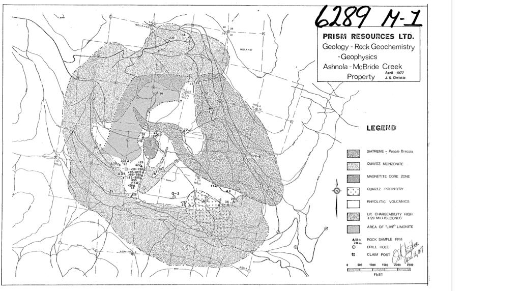
2 TABLE OF CONTENTS Page No. INTRODUCTION LOCATION MAP LOCATION AND ACCESS MINERAL CLAIMS REGIONAL GEOLOGY MINERAL CLAIM MAP PROPERTY GEOLOGY ALTERATION AND MINERALIZATION ROCK GEOCHEMISRTY AND ASSAYING INTERPRETATION RECOMMENDATIONS STATEMENT OF EXPENDITURES CERTIFICATE REFERENCES I ILLUSTRATIONS #I GEOLOGY, ROCK GEOCHEMISTRY AND GEOPHYSICS McBRIDE CREEK PROPERTY, PRISM RESOURCES LTD. In pocket
3 INTRODUCTION In October 1976, while employed by Quintana Minerals Corporation,I was sent to evaluate a large sulfide system on the Ashnola River - McBride Creek property of Prism Resources Ltd.,with a view to possible option of the property by Quintana. The property had been briefly examined by another Quintana geologist, and it was felt that thjs sulfide system was similar in some ways to upper levels in the porphyry copper systems of southwestern U.S.A. It was hoped that a deep diamond drill target could be indicated. I was instructed to note, map and sample any features of the geology that might indicate similarity-with Kerr - McGee's Red Mountain porphyry deposit, Patigonia,Arizona which I had visited in the Fall of At Red Mountain the high grade copper deposit occurs at depths of some 3500 feet beneath very low grade surface exposures rich in pyrite and characterized by strong phyllic alteration- (Corn,1975). Geological examination of bedrock and drill core, surface mapping and rock geochemical sampling were carried out during the 6 day period October 17-22, A base map at the scale of 1"= 4 ' previously prepared by Prism Resources Ltd. and Craigmont Mines was used for control., i
4
5 - 3 - LOCATION AND ACCESS The property is located about 25 miles southwest of Keromeos B.C. on a ridge between McBride and Cat Creeks, 1 mile west of Ashnola River. The geological centre of the deposit is at elevation 6000 feet, some 2700 feet above the local Ashnola base-level. Access is by the Ashnola River valley road and then by a network of 4-wheel drive roads which have been constructed on the property (several are now impassible). MINERAL CLAIMS Mapping was done over parts of the Ash and Nola claims shown on Figure 2 and the accompanying geological map. No attempt was made to locate claim posts or boundaries, and locations shown result from a previous survey by Prism Resources Ltd. and are assumed to be correct. REGIONAL GEOLOGY The property lies within a volcanic sequence comprised of siliceous lavas, breccias and crystal tuffs, tentatively assigned to the Kingsvale Group by Rice, Average composition approximates dacite and small glassy quartz and feldspar phenocrysts are characteristic throughout the system.,
6 I- -.
7 - 5 - PROPERTY GEOLOGY The sulfide system is developed in rhyolitic lavas bearing abundant 1-3 mm quartz eyes and smaller feldspar phenocrysts. Coarser grained quartz porphyries (3-5 mm quartz eyes) form small dykes and stocks. Younger, late-mineral quartz monzonite porphyry forms a small central stock from which dyke-like apophyses emanate. A large diatreme has been mapped and interpreted to be of latest-mineral age. This is cut by minor dykes of fine grained dacite, medium grey in colour. The breccias and pebble dykes comprising the diatreme were previously considered to be pyroclastic members of the volcanic succession. Clasts within the breccias are matrix supported and range up to 100 mm in diameter. Average clast size is less than 10 mm in a fine grained porous matrix grading to igneous matrix, in proximity to related medium greenish grey quartz porphyry dykes. Most clasts are mineralized and include varieties of all rock types mentioned above with exception of post mineral dacite. Mineralization within the clasts is distinctly stronger than in the matrix and more diverse in style and intensity. Disseminated pyrite is the only sulfide within the diatreme matrix. Clasts inaddition display both chalcopyrite and molybdenite, disseminated and along fractures. Three clasts contain molybdenite mineralization of considerably higher grade than any observed at surface.
8 - 6 - ALTERATION AND MINERALIZATION Alteration and sulfide mineral zoning are well developed about a central core area some 800 feet in diameter. Strong magnetite mineralization both fracture controlled and disseminated characterizes core zone rocks, which also contain wide spaced quartz veinlets and less than 1% total sulfides. Outward an annular phyllic zone surrounds this core, wherein easily visible fracture related sericite is distinctive. Rocks of the phyllic zone are more highly fractured than those of the core and contain considerably more sulfide and quartz veinlets. Total sulfide content grades outward from 1% to 5% across the phyllic zone, while pyrite relative to chalcopyrite increases in ratios from 2:l to 50:l. Other mapable features are silicification grading from pervasive to fracture selvage alteration 1000 feet or more distant from the magnetite zone, and smaller zones of argillic alteration contained within the phyllic zone. Argillic alteration may in part be related to supergene processes especially north and east of the core where argillic alteration is associated with "live" limonite and areas of deepest oxidation. Molybdenite in association with chalcopyrite forms easily visible fracture coating within the inner part of the phyllic zone. It is strongest in the southeast and southwest quadrants coincident with a large area of pervasive silicification, which has given rise to hard dense flinty lithologies.
9 - 7 - Molybdenite has also been noted in three mm clasts from the diatreme as seen in the core of diamond drill holes D72-1 and D72-6. While not noticed during field examination the molybdenite was subsequently discovered in 3 of 20 core samples collected during more detailed examination under better light conditions. One molybdenite bearing clast is strongly silicified and similar to the known surface exposures. The other two appear to be softer quartz-sericite altered rocks containing higher grade molybdenite - pyrite mineralization, unlike any observed at surface. Beyond the phyllic zone a strong pyritic zone is developed characterized by pyrite fracture fillings with coatings of chlorite but little visible chalcopyrite. This pyrite halo is horseshoe shaped open to the east, and is well defined by the I.P. high (plus 29 millisecond chargeability contour) shown on the accompanying geology map. Further outward alteration,intensity,fracturing and sulfide mineral content diminish gradually. Minor supergene copper enrichment in the form of chalcocite and cuperite has been reported, and tested by drilling. Maximum enrichment (sub-marginal grade) predictably occurs beneath flatter upland slopes and ridges where greater depths of oxidation and leaching are reported, and the occurrence of "livenlimonite in these areas suggests a multi-cycle enrichment history. Live limonite also appears to approximate the distribution of better-grade hypogene chalcopyrite mineralization internal to the pyrite halo.
10 - 8 - ROCK GEOCHEMISTRY AND ASSAYING Rock geochemical analyses and assays for copper and molybdenum (see map) are consistent with the zonal pattern previously described. Apparent exceptions are oxidized and partially leached samples which are anomalously low especially for copper values. Best hypogene copper grades are in the order of 0.1% Cu, and occur within the inner part of the phyllic zone external to the magnetite core. Strongly silicified rocks are characterized by better than average copper grades. Molybdenum appears to be even more closely restricted than copper,to the innermost phyllic zone. Sample 76C 366 (79 ppm Mo) is however a noteworthy exception which suggests that the quartz porphyry stock,southeast of the magnetite, may be associated with a second molybdenum high. Outcrops and sampling in the area is not sufficiently abundant to provide any real definition in that vicinity, but a nearby diamond drill hole - Q-3 also contained strongly anomalous Mo, and assays indicated a definite increasing grade trend with depth. INTERPRETATION The results of this examination have confirmed that no nearsurface target worthy of exploration is present at the YcBride Creek property. However it appears advisable to further consider the geology and zonal patterns described in the light of several conceptual models, before evaluating the possibility of deeper targets.
11 - 9 - In comparison to the Red Mountain porphyry copper model little if any similarities are present at McBri.de Creek. The rhyolitic volcanic succession and related quartz porphyry intrusives do not closely resemble the andesite - quartz monzonite - monzonite suite at Red Mountain. Futher if the McBride prospect is actually a porphyry copper system,strong arguments may be advanced to suggest that it represents a fairly deep level rather than high level of exposure. The 2:l ratio of pyrite to chalcopyrite in rocks of sub-marginal copper grade but pervasive quartz sericite (phyllic) alteration, external to magnetite bearing (barren-core) rocks is fairly typical of the innermost zones of most porphyry copper models. If ore grade copper is not encountered in such rocks little may be said to recommend deeper exploration. Copper grade would be more likely to diminish with depth. Comparison at the McBride Creek prospect with a deep model porphyry molybdenum deposit such as Henderson could be more rewarding. The moly porphyries are typically associated with siliceous rhyolite-quartz porphyry suites such as this,and the rock types at Henderson are closely similar. Also at Henderson high level chalcopyrite bearing and magnetite bearing shells occur, well above the Mo orebodies. Direct although tenuous evidence suggesting that deep seated molybdenum mineralization may be present has been found at McBride Creek, in the form of possible ore grade mineralized clasts in the diatreme. Further evaluation may be easily and relatively cheaply undertaken by further studying the geochemistry. Porphyry moly deposits typically have generally high background levels and strong zonal patterns in such elements as W, Sn, F that are amenable to rock geochemical study. The core from the diafcreme could also be re-examined to determine more precisely relative abundance and nature of molybdenum mineralization occurring therein as compared to surface mineralization. 4
12 Less significant but noteworthy are the implications of re-interpretation as a diatreme, of rocks previously mapped as fragmental rhyolite volcanics. The age of the diatreme is interpreted as late-mineral, post copper-moly and inspection of the map leads to the interpretation that the diatreme is likely responsible for the incomplete, horseshoe shape I.P. high. It appears to have effectively "blown a hole" in the east side of the pyritic shell. A zone of potassic alteration, outlined by Sinclair, 1975 on the basis of considerable petroqraphic work, was presented as the likely alteration centre of the McBri.de Creek system. This xone, while centrally located, was found to be essentially co-extensive with the outcrop of a quartz monzonite stock interpreted to be of very late-mineral age. It is believed to be younger than the strong hydrothermal event which gave rise to the principal zonal patterns of alteration and mineralization. RECOMMENDATIONS The McBride Creek property of Prism Resources Ltd., warrants further geological work with the objective of establishing affinity with known porphyry molybdenum sulfide systems. The following should be done to provide a basis for additional exploration, specifically deep diamond drilling, if warranted. In this regard it should be noted that a 2200 foot difference in elevation exists between the floor of Ashnola River valley and the surface exposures of the central part of the system. For the purpose of mining a relatively short decline could be driven to reach an orebody feet below the surface.
13 - 11-1) Detailed geological mapping of all outcrops combined with rock geochemical sampling, to thoroughly study the entire area internal to the pyrite halo. 2) Rock geochemical analysis for Cu-Mo-Pb-Zn-Sn-W-F with attention given to the degree of surface oxidation in interpretation. 3) Detailed examination of all available drill-core from the diatreme to study frequency of occurrence and style of molybdenum mineralization within the clasts. 4) If warranted, two or more foot deep diamond drill holes based on results of foreqoing work. Respectfully submitted u James S. Christie, Ph.D. I. -
14 STATEMENT OF EXPENDITURES 1) Property Mapping and Evaluation J.S. Christie October 17-22, $150/day $ ) Preparation of Report, Maps, Illustrations J.S. Christie April 3-4, $150/day ) Drafting,typing,duplication 4) Vehicle Rental - 4-wheel drive Blazer 1/4 $750/month ) Accomodation - motel 5 $18/niqht ) Food - 6 $15/day ) Geochemical analysis and Assays $1, i
15 13 - CERTIFICATE I, James S. Christie of North Vancouver, British Columbia do hereby certify that. 1) I am a Professional Geologist residing at 191 Rondoval Crescent, North Vancouver, B.C. V7N 2W6. 2) I am a graduate of the University of British Columbia, B.Sc. Honours Geology , Ph.D. Geology ) I have practiced my profession as a mining exploration geologist, continuously since ) I am a Fellow of the Geological Association of Canada. 5) I am a Member of the Geological Society of America. 6) I have no interest direct or indirect in any property of Prism Resources Limited nor do I expect to receive any such interest for writing this report. 7) This report is based on my persoanl knowledge of the district, an examination of the geology at the property and the literature cited. James S. Christie, Ph.D. April, 1977
16 mferences 1) Cochrane D.R., Giroux, G., Scott, A., 1970, Geophysical and Geochemical Report on Prism Resources Ashnola Property. 2) Corn, R.M., 1975, Alteration-Mineralization Zoning, Red Mountain,Arizona. Econ Geol. V, 70, 1975, pp ) Lowell, J.D., 1968, Private Quintana Minerals Corporation Report on McBride Creek Deposit. 4) Montgomery, J.H., 1968, Report on Diamond drillinq of the St. Louis Project 10soyoos Mining Division, British Columbia for Quintana Minerals Corporation. 5) Montgomery, J.H., Cochrane, D.ROf and Sinclair, A.J., 1975, Discovery and Exploration of Ashnola Porphyry Copper Deposit, near Keremeos, B.C., a Geochemical Case History. 6) Rice, H.M.A., 1960, Geology and Mheral Deposits of the Princeton Map Area, British Columbia. G.S.C. Mem. 243.
17 COMPAP-~ Quintana Minerals.. 1 I. GEOCHEMICA~".INALYSIS DATA SHEET -ILL No.30 0 o.-..
18 COAfPA: PRO.IECT Nn a ATTENTION. Q u i 11 t an a M in e r a 1 s - J..Chr_i.s - _- GEOCHEMICAL 4LYSIS DATA S1.tZET MIN - EN Loboratoricr Ltd t-ie 705 WEST ST. NORTH VANCOUVER, 9 f. PHONE (604) V7M I r2 r NO DATE: Nov*
19 705 WEST 15TH STREET NORTH VANCOUVER, B.C. Phonr: TO: Quintsna Ytneral Explorations, PROJECTN~. J. Christie #2 Bcntall Centre, DATE NOV. 8/76. Vancouver. i3.c. File No ,f '...,. ' CERTIFIED wy-',.,2,.,... 6d.4....
20 To:- ana Minerals C o r w ion REPORTNo A2 927 PAGENo. BBNDAR-CLEW & COMPANY LTD. DATE: Nov 23, Burrard Street Samples submitted: Nov 18, 1976 Vancouver, B.C. CERTIFICATE OF ASSAY Results completed: Nov 23, 1976 V7X 1M9-1
21
GEOLOGICAL MAPPING REPORT ON THE ASH MINERAL CLAIM OSOYOOS MINING DIVISION ASHNOLA RIVER MAP SHEET NTS M092,H019 MCBRIDE CREEK AREA, ASHNOLA RIVER,
 GEOLOGICAL MAPPING REPORT ON THE ASH MINERAL CLAIM OSOYOOS MINING DIVISION ASHNOLA RIVER MAP SHEET NTS M092,H019 LATITUDE 49 o O6, LONGITUDE 120 o 22 MCBRIDE CREEK AREA, ASHNOLA RIVER, KEREMEOS, B.C. CANADA
UNION MINIERE EXPLORATIONS AND MINING CORPORATION LIMITED ASSESSMENT REPORT ON FITINAT MINERAL CLAIM. Alberni Mining Division Record No.
 M F )( UNION MINIERE EXPLORATIONS AND MINING CORPORATION LIMITED Suite 200, 4299 Canada Way, Burnaby, B.C. V5G 1 H4 Telephone (604) 437-9491 ASSESSMENT REPORT ON GEOCHEMICAL SOIL SURVEYS AND ROCKSAMPLING
DISCOVERY OF MINERALISED PORPHYRY & MAGNETITE-COPPER-GOLD AT KAMARANGAN
 MEDUSA MINING LIMITED ABN: 60 099 377 849 Unit 7, 11 Preston Street Como WA 6152 PO Box 860 Canning Bridge WA 6153 Telephone: +618-9367 0601 Facsimile: +618-9367 0602 Email: admin@medusamining.com.au Internet:
CREATING VALUE THROUGH DISCOVERY IN SOUTH AMERICA. Lara Copper Project. Lara 45%-Owned Property in Southern Peru
 CREATING VALUE THROUGH DISCOVERY IN SOUTH AMERICA Lara Copper Project Lara 45%-Owned Property in Southern Peru 1 Forward Looking Statements Except for statements of historical fact relating to the Company,
Revelo Defines Porphyry Copper Targets at its Calvario Project
 www.reveloresources.com NEWS RELEASE #01/2015 Revelo Defines Porphyry Copper Targets at its Calvario Project Vancouver - February 03, 2015 - Revelo Resources Corp. ( Revelo or the Company ) (TSX-V: RVL)
NEW HAZELTON, OMINECA M.D.,
 PROSPECTING REPORT JUDI 1 TO 6 MINERAL CLAIMS NEW HAZELTON, OMINECA M.D., B.C. MAP 93M/4E, LAT. SS014'N, LONG. 127'33'W OWNED BY: A. L'ORSA ANTHONY L'ORSA Smithers, B.C. 21 February, 1981 TABLE OF CONTENTS
lat ' N Long ' W
 305 7 ec1;, REPORT ON THE JERY CLAIMS OF POLA RESOURCES LTD. NTS 93L/16 0 0 lat. 54 45' N Long. 126 22' W BABIXE LAKE AREA OMINECA MINING DIVISION, B.C. PAUL PLICKA CONSULTING GEOLOGIST DECEMBER 30, 1981
compietea since tnat date, and wnicn comprisea btage I ot tne recommended
 compietea since tnat date, and wnicn comprisea btage I ot tne recommended four-stage program. GEOLOGY & MINERALIZATION The property situate6 on the southeast slope of Nickel Plate Mtn., and within the
Drill locations for the 2015 program are highlighted in the geology map below.
 2015 Exploration Program The exploration program plan at KSM for 2015 was designed to improve the understanding of block cave targets and support engineering/environmental aspects of development scenarios.
GEOLOGY OF THE NICOLA GROUP BETWEEN MISSEZULA LAKE AND ALLISON LAKE
 GEOLOGY OF THE NICOLA GROUP BETWEEN MISSEZULA LAKE AND ALLISON LAKE (92H/15E. 10E1 By V. A. Preto INTRODUCTION Mapping was continued southward from the area covered in 1973 and an additional 55 square
SPL 1452 NAMOLI & WAINIVAU GOLD AND COPPER PROSPECTS
 SPL 1452 NAMOLI & WAINIVAU GOLD AND COPPER PROSPECTS (Multiple Namosi-like Exploration Targets) SPL1452 being contiguous with the Namosi SPL1420 owned by the Newcrest Joint Venture and with the same type
A PRELIMINARY REPORT ON THE ZYMOST2 CLAIM GROtP, TERRACE, B.C.
 NATIVE EXPLORATIONS LTD. A PRELIMINARY REPORT ON THE ZYMOST2 CLAIM GROtP, TERRACE, B.C. INTRODUCTION': The Zymoetz claim group is, at present, held under option by Native Explorations Ltd.. On the 19th
ASX Announcement. 28 January Drill results indicate large Porphyry Copper Gold System at Peenam
 ASX Announcement 28 January 2010 Drill results indicate large Porphyry Copper Gold System at Peenam Highlights: 270 metres of visible copper (gold) mineralisation in first diamond core hole at Peenam Prospect
COPPERSTONE RESOURCES AB INTERCEPTS ZONE OF CHALCOPYRITE-ARSENOPYRITE- BORNITE MINERALIZATION AT SVARTLIDEN IN FIRST DEEP DRILLHOLE FROM 720m-810m
 COPPERSTONE RESOURCES AB INTERCEPTS ZONE OF CHALCOPYRITE-ARSENOPYRITE- BORNITE MINERALIZATION AT SVARTLIDEN IN FIRST DEEP DRILLHOLE FROM 720m-810m In mid-january 2017 Copperstone Resource published a geological
Alteration and Mineralization at Daralu Porphyry Copper Deposit, South of Kerman, Southeast Iran
 Alteration and Mineralization at Daralu Porphyry Copper Deposit, South of Kerman, Southeast Iran Mosayeb Salehian* and Majid Ghaderi Department of Geology, Tarbiat Modares University, Tehran, Iran *Email
LOS AZULES April 2018
 April 2018 lies along the southern extensions of the highly productive Paleocene Mineral Belt in northern Chile that contains numerous important copper, gold and silver mines and projects, and to the south
For personal use only
 ANNOUNCEMENT TO THE AUSTRALIAN SECURITIES EXCHANGE: 28 NOVEMBER 2012 DRILLING UPDATE MABILO PROJECT The Directors of Sierra Mining Limited ( Sierra ) are pleased to announce further results from reconnaissance
Focus Acquires Porphyry Copper-Molybdenum Project, Peru; Historical Drilling includes 0.57% Cu and 0.7% Cu
 Focus Acquires Porphyry Copper-Molybdenum Project, Peru; Historical Drilling includes 190m @ 0.57% Cu and 71.7m @ 0.7% Cu July 11, 2012; Vancouver, Canada: Focus Ventures Ltd. (TSX-V: FCV) is pleased to
TOPOGRAPHICAL SURVEY REPORT ON THE GREENDROP PROPERTY NEAR CHILLIWACK, B.C. 92-H-3/W
 TOPOGRAPHICAL SURVEY REPORT ON THE GREENDROP PROPERTY NEW WESTMINSTER M.D. NEAR CHILLIWACK, B.C. 92-H-3/W Location: The central pap of the claims is located at coordinates 49 08'N, latitude by 121 26'W,
RECONNAISSANCE GEOCHEMICAL SURVEY
 RECONNAISSANCE GEOCHEMICAL SURVEY LEGAL, RITA, LOUISE FR. (CHAPLEAU GROUP) REVERTED CROWN GRANTS CHAPLEAU CREEK AREAJ, SLOC& MINING DIVISION 82 F/11W Lat: 49'44" Long: 117"22'W MINERAL RESOURCES BRANCH
News Release No GOLD AND COPPER MINERALIZATION DISCOVERED DURING PHASE 2 EXPLORATION AT THE MCBRIDE PROPERTY
 November 19, 2018 TSX Venture Exchange Listed Frankfurt Exchange Listed News Release No. 303-2018 GOLD AND COPPER MINERALIZATION DISCOVERED DURING PHASE 2 EXPLORATION AT THE MCBRIDE PROPERTY Vancouver,
PROSPECTING REPORT THE WALLACE CLAIM OMENICA MINING DIVISION. 54" x6" 3.d d. for. Reako Exlorat ions Ltd. Wallace Rev. C.G.
 PROSPECTING REPORT ON THE WALLACE CLAIM OMENICA MINING DIVISION 54"44 14 1x6" 3.d d by David A. Howard P.Eng. for Reako Exlorat ions Ltd. Claim Locat ion Wallace Rev. C.G. #1560 Dome Mountain Area 9 3
Discovery of Thick Zone of Magnetite-Rich M Veins Strengthens Potential for Nearby Porphyry
 Thursday s Gossan Copper-Gold Porphyry Diamond Drilling Update Discovery of Thick Zone of Magnetite-Rich M Veins Strengthens Potential for Nearby Porphyry ~100m intercept of magnetite-rich M -veins and
1 CLAIMS GEOPHYSICAL REPORT ON BOYAL SITUATE NORTHEAST OF TILLICUM MOUNTAIN GOLD AREA BURTON - NAKUSP SIQCAEJ MINING DIVISION
 GEOPHYSICAL REPORT ON BOYAL 1 CLAIMS SITUATE NORTHEAST OF TILLICUM MOUNTAIN GOLD AREA BURTON - NAKUSP SIQCAEJ MINING DIVISION CONSULTING GEOLOGIST AUGUST 1983 VANCOUVER B *C INDEX INTRODUCTION ooa,.eoaaa.aaaoaaooaoa~ao~o
Serengeti Resources Inc GEOCHEMICAL REPORT ON THE SHADOW PROPERTY a.
 Serengeti Resources Inc. 2004 GEOCHEMICAL REPORT ON THE SHADOW PROPERTY a. Located in the Johanson Lake Area Omenica Mining Division NTS 94D/9 6 degrees and 32 minutes North Latitude 126 degrees and 2
LINGIG PORPHYRY COPPER DISCOVERY
 MEDUSA MINING LIMITED ABN: 60 099 377 849 Unit 7, 11 Preston Street Como WA 6152 PO Box 860 Canning Bridge WA 6153 Telephone: 618-9367 0601 Facsimile: 618-9367 0602 Email: admin@medusamining.com.au Internet:
3 I1 I I Ill 111 II! II 111 II Ill I IlE I I P I
 -7 3 1 1 11111111111111111111111111111111 ll 111! 111 111 111 111 111111111111111 ll 1111111 1 11111111111111 le P GEOCHEMCAL SURVEY OF THE KE AND D'ARCY CLAM GROUPS.. Similkameen Mining Division, B.C.
NEWS RELEASE. Empire Mining Corporation 1090 Hamilton Street Vancouver, B.C. V6B 2R9
 Empire Mining Corporation 1090 Hamilton Street Vancouver, B.C. V6B 2R9 Phone: (604) 634-0970 Fax: (604) 634-0971 Toll Free: 1 888 818-1364 info@empireminingcorp.com www.empireminingcorp.com NEWS RELEASE
Figure 1: Location of principal shallow conductors at Alpala (anomalies C0-C10; 5 Ohm/m surfaces, red) and shallow zones of electrical chargeability
 and shallow zones of electrical chargeability") Figure 1: Location of principal shallow conductors at Alpala (anomalies C0-C10; 5 Ohm/m surfaces, red) and shallow zones of electrical chargeability (85 msecs, yellow-green) shown on iso-surfaces of MVI
Figure 1: Location of principal shallow conductors at Alpala (anomalies C0-C10; 5 Ohm/m surfaces, red) and shallow zones of electrical chargeability (85 msecs, yellow-green) shown on iso-surfaces of MVI
HOWE COPPER MINE PROJECT HIGH GRADE Cu-Ag with Au
 HOWE COPPER MINE PROJECT HIGH GRADE Cu-Ag with Au The Howe Copper Mine property is located approximately 55 kilometres northwest of Vancouver, BC. It is situated at 1431 metres elevation on the eastern
SECOND DRILL HOLE IHAD2 INTERSECTS MINERALIZED TAPLEY HILL FORMATION AND MINERALIZED BASEMENT IRON FORMATION
 Suite 304, 22 St Kilda Road St Kilda Vic 3182 Ph: +61 3 9692 7222; Fax: +61 3 9529 8057 For Immediate Release 14 th September 2007 SECOND DRILL HOLE IHAD2 INTERSECTS MINERALIZED TAPLEY HILL FORMATION AND
NEWS RELEASE. Evrim announces initial drilling results at Cuale Gold Project in Mexico
 910-850 WEST HASTINGS ST. VANCOUVER, BC, CANADA V6C 1E1 TEL: 604.248.8648 FAX: 604.248.8663 WWW.EVRIMRESOURCES.COM TSX-V: EVM CONTACT: PADDY NICOL OR CHARLES FUNK NEWS RELEASE Evrim announces initial drilling
PRECIOUS METALS. owner. JMT Services Corp. GEOCHPlICAL SAMPLING CHELASLIE WCE, NORTH CENTRAL, B.C. OMINECA MINING DIVISION NTS 93F/5E & 6W
 PRECIOUS METALS REPORT ON 1980 RECONNAISSANCE GEOCHPlICAL SAMPLING CHELASLIE WCE, NORTH CENTRAL, B.C. OMINECA MINING DIVISION NTS 93F/5E & 6W LATITUDE 53O28 N LONGITUDE 125O31 W DATES Qp WORK: JULY 10
2013 GEOLOGICAL ASSESSMENT REPORT SHERIDAN HILL PROPERTY
 2013 GEOLOGICAL ASSESSMENT REPORT ON THE SHERIDAN HILL PROPERTY NEW WESTMINSTER MINING DIVISION BRITISH COLUMBIA NTS 092G07 49 16 31 NORTH LATITUDE, 122 39 48 WEST LONGITUDE PREPARED FOR Sheridan Hill
ASSESSMENT REPORT. Geochemical and Geological Surveys. on the. Gooch#1-4. Mineral Claims. Omenica Mining District NTS 93L/7W
 f- GEOLOGICAL BRANCH ASSESSMENT REPORT ASSESSMENT REPORT Geochemical and Geological Surveys on the Gooch#1-4 Mineral Claims Omenica Mining District NTS 93L/7W LAT: 54O25'W LONG: 126O26'W Operator: SMD
NTS 93L/9W GEOCHEMICAL AND GEOPHYSICAL REPORT MONA CLAIM OMINICA MINING DIVISION. Lati tude 54036'N; Longitude 'W
 GEOCHEMICAL AND GEOPHYSICAL REPORT ON MONA CLAIM OMINICA MINING DIVISION Lati tude 54036'N; Longitude 126018'W NTS 93L/9W April 1981 Paul Plicka Consulting Geologist LOCATION MAP INTRODUCTION TABLE OF
GEOCSZNICAL - SURVEY. ICAMLOOPS Kl.D. 2'' 6;kr. HY "'f. Alfred R. Allen,P.Eng. 1 NO.%=...,... 6"- 'I.
 t i.i GEOCSZNICAL - SURVEY i p' ICAMLOOPS Kl.D. 2'' 6;kr HY 50-64 +."'f 121-51 NE 5-10-70 : 19-10-70 Alfred R. Allen,P.Eng. I) ' 1 6"- 'I. 1 NO.%=...,..... Q.C. EXPLORATIONS LTD. 2Cl- 535 Kowe Street Vancouver
Summary of Rover Metals Geologic Mapping Program at the Up Town Gold Project, Northwest Territories
 October 13, 2017 Summary of Rover Metals Geologic Mapping Program at the Up Town Gold Project, Northwest Territories Vancouver, British Columbia, Canada - Rover Metals Corp., Rover, is pleased to provide
ENCOURAGING GOLD-BASE METALS AT MAY DAY, MOLY- GOLD AT ATTUNGA
 ASX / MEDIA RELEASE 5 JULY 2010 ENCOURAGING GOLD-BASE METALS AT MAY DAY, MOLY- GOLD AT ATTUNGA Peel Exploration is pleased to announce that recent drilling at the Company s Attunga and May Day projects
Wind Mountain Project Summary Memo Feeder Program
 A Manex Resource Group Company Wind Mountain Project Summary Memo Feeder Program J.A. Kizis, Jr., February 07, 2018 Assays have been received for both holes drilled at Wind Mountain during late 2017 and
JOSH LEIGH Project Exploration Geologist June ASX Code AIV
 COALSTOUN AND BOOUBYJAN Porphyry Copper-Gold Complexes, their structural setting, geology and geochemistry Joshua Leigh 1, Doug Young 2, Jose Veracruz 3, Paul Ashley 3 - ( 1 ActivEX Limited, 2 Consultant,
BALFOUR MINING LTD. (N.P.L.) HAM GROUP 92-P-6, CLINTON M. D.8 B. C. Lat 51 17'N, GEOCHEMICAL REPORT. V. CUKOR, P. Eng.
 HAM GROUP 92-P-6, CLINTON M. D.8 B. C. Lat 51 17'N, GEOCHEMICAL REPORT. V. CUKOR, P. Eng.") 34q '7 BALFOUR MINING LTD. (N.P.L.) HAM GROUP 92-P-6, CLINTON M. D.8 B. C. Lat 51 17'N, Long 12lo14'W GEOCHEMICAL REPORT, V. CUKOR, P. Eng. January 31, 1972 TABLE OF CONTENTS 1. INTRODUCTION 2. PROPERTY,
34q '7 BALFOUR MINING LTD. (N.P.L.) HAM GROUP 92-P-6, CLINTON M. D.8 B. C. Lat 51 17'N, Long 12lo14'W GEOCHEMICAL REPORT, V. CUKOR, P. Eng. January 31, 1972 TABLE OF CONTENTS 1. INTRODUCTION 2. PROPERTY,
GEOLOGY AND LITHOGEOCHEMISTRY OF THE CHILKO-TASEKO LAKES AREA* BY G.
 B Ministry of Energy, Mines and Petroleum Resources GEOLOGICAL BRANCH MINERAL RESOURCES DIVISION NOTES TO ACCOMPANY OPEN FILE - GEOLOGY AND LITHOGEOCHEMISTRY OF THE CHILKO-TASEKO LAKES AREA* BY G. P. McLAREN
PROSPECTORS ASSISTANCE PROGRAM MINISTRY OF ENERGY AND MINES
 BRITISH COLUMBIA PROSPECTORS ASSISTANCE PROGRAM MINISTRY OF ENERGY AND MINES GEOLOGICAL SURVEY BRANCH PROGRAM YEAR: 1999/2000 REPORT #: PAP 99-l 6 NAME: KIM ANSCHETZ PROSPECTORS TlEPORT on the 99 LOUIS
The Cobalt Rainbow. Airborne geophysical maps show that a north trending aeromagnetic high suggests further undiscovered mineralisation.
 The Cobalt Rainbow The property is located on Greenstone Creek, approximately 4.8 kilometres south west of the creek mouth. The property is located about 24 km due west of Campbell River, in the east-central
SECOND and THIRD YEAR ASSESSMENT REPORT PROSPECTING LICENCE M, ROCK CUT PROPERTY, NTS 1N/12, NEWFOUNDLAND. ROY FRENCH (licence holder )
") SECOND and THIRD YEAR ASSESSMENT REPORT Of PROSPECTING On LICENCE 013704M, ROCK CUT PROPERTY, NTS 1N/12, NEWFOUNDLAND. By ROY FRENCH (licence holder ) Work Conducted: Sept. 17, 2008 Nov. 03, 2009 Total
SECOND and THIRD YEAR ASSESSMENT REPORT Of PROSPECTING On LICENCE 013704M, ROCK CUT PROPERTY, NTS 1N/12, NEWFOUNDLAND. By ROY FRENCH (licence holder ) Work Conducted: Sept. 17, 2008 Nov. 03, 2009 Total
SIMUKU DRILLING TO OVER 1000 METRES DEMONSTRATES SIGNIFICANTLY INCREASED TONNAGE POTENTIAL OF THE INFERRED RESOURCE
 ADDRESS PHONE PO Box 6965 +61(07) 5592 1001 Gold Coast Mail Centre FAX Qld 9726 Australia +61 (07) 5592 1011 EMAIL ABN 54 126 490 855 info@coppermoly.com.au WEBSITE www.coppermoly.com.au ASX Announcement
Revelo Completes Geological Review of its Montezuma Copper-Gold Project & Defines Priority Targets
 www.reveloresources.com NEWS RELEASE # 17 / 2017 Revelo Completes Geological Review of its Montezuma Copper-Gold Project & Defines Priority Targets Vancouver December 12, 2017 Revelo Resources Corp. (
POTENTIAL OF THE DONGWE COPPER GOLD PROJECT
 POTENTIAL OF THE DONGWE COPPER GOLD PROJECT By Nathan Sabao, P.Geo. September 2015 1 TABLE OF CONTENTS Page 1.0 EXECUTIVE SUMMARY 1 2.0 LOCATION 2 3.0 ACCESS 2 4.0 GEOLOGY 3 5.0 PREVIOUS DRILLING 5 6.0
Revelo Reports on Initial Drill Test of its Cerro Buenos Aires Project
 www.reveloresources.com NEWS RELEASE # 7 / 2018 Revelo Reports on Initial Drill Test of its Cerro Buenos Aires Project Vancouver September 18, 2018 Revelo Resources Corp. ( Revelo or the Company ) (TSX-V:
J.D. Mason, Prof. Engineer. Report on the Reconnaissance Magnetometer Survey. Completed for. North American Platinum Corporation Ltd.
 Report on the Reconnaissance Magnetometer Survey Completed for North American Platinum Corporation Ltd. Olivine Mountain Property, Tulameen, B.C. J.D. Mason, Prof. Engineer. November 28, 1967. Certificate
CONTENTS. Location, Access and History...6. Tenure Status and Geology Regional Andy Property Geology Map...9
 TYPE OFWORK IN THIS REPORT EXTENT OF WORK (rn METRTC UNITS) ON WHICH CLAIMS PROJECT COSTS APPORTIONED (incl. support) GEOLOGICAL (scale, area) Ground, mapping Photo interpretation GEOPHYSICAL (line-kilometres)
ASSESSMENT REPORT ON THE PEAVINE PROJECT. DGW & Associates # Alberni Street, Vancouver, British Columbia, V6E 4V2
 ASSESSMENT REPORT ON THE PEAVINE PROJECT KAMLOOPS MINING DIVISION BRITISH COLUMBIA NTS 082M 12 Latitude 51 36' 19.0"North -- Longitude --119 47' 27.0"West UTM Zone 11, NAD 83 5720827N 306744E Prepared
For personal use only
 ASX QUARTERLY REPORT GEOPACIFIC RESOURCES NL ACN 003 208 393 ASX Code: GPR info@geopacific.com.au www.geopacific.com.au AUSTRALIAN OFFICE Suite 6, 125 Melville Parade Como, WA 6152 SEPTEMBER 2012 QUARTERLY
For personal use only
 ASX RELEASE 13 July 2012 ASX Code: PMQ Encouraging Field Exploration Results: Mount Borium Gold Project Key Points Third phase of field exploration underway the Company has been highly active since the
EXISTING GEOLOGICAL INFORMATION
 CHAPER 3 EXISTING GEOLOGICAL INFORMATION 3-1 General Geology of the Surrounding Area (1) General geology and ore deposits in Mongolia Geographically, Mongolia is a country located between Russia to the
The MAPLE BAY PROJECT Copper Silver - Gold
 The MAPLE BAY PROJECT Copper Silver - Gold Good grade and tonnage potential within close proximity to Tidewater The Maple Bay Copper Silver Gold Project covers highly favourable geological host rocks of
Elephant Mountain, Alaska Intrusive Related Gold Project July Option to Earn 100%
 Elephant Mountain, Alaska Intrusive Related Gold Project July 2018 Option to Earn 100% CORPORATE Corporate DISCLOSURE Disclosure The information contained herein, while obtained from sources which we believe
 >
> Rich Saddle North Au-Cu-Ag Porphyry Expands by 275m Along Strike and 250m Down-Dip
 GT Gold Drills 281 Metres of 0.65 g/t Au, 0.38% Cu, 1.38 g/t Ag (1.24 g/t AuEq 1 ) Within 685 Metres 2 of 0.40 g/t Au, 0.26% Cu, 1.03 g/t Ag (0.81 g/t AuEq) in Step-out Hole TTD098 Rich Saddle North Au-Cu-Ag
for the Greenwood Mining Division, B.C. NTS 82E/7W 29' W, Longitude 118' 53' N Prepared by D. Dylan Watt, B.Sc.
 for the FltE NO: u VOLT 1, VOLT 2, VOLT 3, & VOLT 4 CLAIMS Greenwood Mining Division, B.C. NTS 82E/7W Latitude 49' 29' W, Longitude 118' 53' N Prepared by D. Dylan Watt, B.Sc. #309-1996 Trutch Street Vancouver,
on the SALAL CREEK MOLYBDENUM PROPERTY, SALAL CREEK, B.C. LILLOOET MINING DIVISION, BRITISH COLUMBIA
 on the J PLUG 9-12, PLUG 19-24, BAT 10-14, BAT 15 Fr., BAT 16 Fr. MINERAL CLAIMS, SALAL CREEK MOLYBDENUM PROPERTY, SALAL CREEK, B.C. LILLOOET MINING DIVISION, BRITISH COLUMBIA N.T.S. 92 J 14 LATITUDE 50
Fletcher Junction Project Technical Update December 18, 2008
 Fletcher Junction Project Technical Update December 18, 2008 Disclaimer Warning! The business of Gold Exploration can be FUN, but it can also be hazardous to your physical, emotional, spiritual and financial
Condor Resources, Inc.
 Research applied to mineral exploration Observations on the Pucamayo Au-Cu prospect, Ica Department, Peru Elongate fragmental body of sub-angular residual quartz clasts, some cut by veinlets after initial
REVIEW OF HISTORIC DIAMOND CORE CONFIRMS COPPER PORPHYRY POTENTIAL AT CERRO BLANCO PROJECT
 Unit 9, 44 Belmont Ave Belmont WA 6104 (PO Box 745, Belmont, WA 6984) Perth, Western Australia Tel: +61 8 6140 2567 Email: info@argentinamining.com.au ASX:AVK 10 March 2011 ASX ANNOUNCEMENT REVIEW OF HISTORIC
The survey covered claims, in part or in full, DUCKLING 3, 4, 5, 4 fraction, and 5 fraction.
 514 687-6671 XXX- 602 West Hastin~a StroeP, Vata;sn@ouver, BritlsA fhlum~b~a, Garaadsa B81apphgtaa DISCUSS ION OF MAGNETOMETER SURVEY ON DUCKLING CLAIMS FOR DONNA MINES LTD. (N0P.L.) Submitted to: DONNA
BCGold Corp. Discovery Driven
 BCGold Corp. Discovery Driven Sickle-Sofia Property Copper-Gold Porphyry Discovery in the Toodoggone Camp! Cautionary Statement This presentation does not constitute an offer to sell or solicitation of
Notes: Note. Township of GODSON Report NQ: 12. Diamond Dniiing. Hole NQ Footage Date. July/56. July/56. Aug/56. Aug/56. Claim NQ 487' K ' l-a
 Diamond Dniiing S2F«4NW«194 12 GODSON 010 Township of GODSON Report NQ: 12 Work performed by: KENNCO EXPLORATIONS (CANADA) LTD. Claim NQ Hole NQ Footage Date Note K 25434 l 487' July/56 l-a 48' July/56
FIRST 2 DRILL HOLES AT NAKRU-2 PROSPECT BOTH INTERSECT SIGNIFICANT HIGHER GRADE COPPER MINERALISATION
 ADDRESS PHONE PO Box 6965 +61(07) 5592 1001 Gold Coast Mail Centre FAX Qld 9726 Australia +61 (07) 5592 1011 EMAIL ABN 54 126 490 855 info@coppermoly.com.au WEBSITE www.coppermoly.com.au ASX Announcement
W. 1.NELSON Jr. P. ENG.
 GEOCHEMICAL AND GEOPHYSICAL SURVEY SNO GROUP CLAIMS W. 1.NELSON Jr. P. ENG. NORANDA EXPLORATION COMPANY, LIMITED OMINECA MINING DIVISION AUG. 17, 1971 - AUG. 29, 1971 TABLE OF CONTENTS - Page INTRODUCTION
RECENT RESULTS FROM THE COMPANY S EXPLORATION PROGRAMME AT PROSPERO (PAMPAMALI NORTH) PROSPERO HIGHLIGHTS
 PROSPERO HIGHLIGHTS") 7 October 2015 Hunter Resources plc ( Hunter or the Company ) (AIM: HUN) RECENT RESULTS FROM THE COMPANY S EXPLORATION PROGRAMME AT PROSPERO (PAMPAMALI NORTH) The Company is pleased to announce the results
7 October 2015 Hunter Resources plc ( Hunter or the Company ) (AIM: HUN) RECENT RESULTS FROM THE COMPANY S EXPLORATION PROGRAMME AT PROSPERO (PAMPAMALI NORTH) The Company is pleased to announce the results
Mineral Claims. Aspen Grove Area Nicola Mining Division, British Columbia. Latitude N., Longitude W. NTS Map Sheet 92H/lSE
 Mineral Claims Aspen Grove Area Nicola Mining Division, British Columbia Latitude 49 51 N., Longitude 120 35 W. NTS Map Sheet 92H/lSE James P. Balmer, B.SC., P.Geo. on behalf of Gary Brown November 26,2003
NEW GOLD AND COPPER DISCOVERY IN CENTRAL OYU ZONE AT TURQUOISE HILL PROJECT IN MONGOLIA S GOBI DESERT REGION
 For Immediate Release March 5, 2002 NEW GOLD AND COPPER DISCOVERY IN CENTRAL OYU ZONE AT TURQUOISE HILL PROJECT IN MONGOLIA S GOBI DESERT REGION HIGH-GRADE GOLD AND COPPER MINERALIZATION EXTENDED TO A
CSA Mine Observations Applied to the Development of Regional Exploration Models
 CSA Mine Observations Applied to the Development of Regional Exploration Models 1 Introduction Recent work completed by the geology team has resulted in an improved understanding of the CSA mine system
Drilling at Perseverance in Arizona, USA Suggests Proximity to Porphyry Copper System
 Drilling at Perseverance in Arizona, USA Suggests Proximity to Porphyry Copper System Cordoba and Bell Copper Will Bring HPX s Typhoon Geophysical System to Site TORONTO, ONTARIO, January 21, 2018: Cordoba
LOS CALATOS DRILLING RESULTS TD2 TARGET
 ASX ANNOUNCEMENT 18 April 2016 LOS CALATOS DRILLING RESULTS TD2 TARGET Metminco Limited ( Metminco or the Company ) (ASX: MNC; AIM: MNC) advises that the drilling of a single drill hole at the TD2 Target
FIRST YEAR ASSESSMENT REPORT PROSPECTING LICENCE 16512M MARYSTOWN AREA, BURIN PENINSULA NTS 1M/3
 FIRST YEAR ASSESSMENT REPORT OF PROSPECTING ON LICENCE 16512M MARYSTOWN AREA, BURIN PENINSULA NTS 1M/3 BY NATHANIEL NOEL MSc. FOR E. MICHELE NOEL MINERAL LICENCES: 16512 M WORK CONDUCTED: MID-SEPTEMBER
A FIELD EVALUATION OF THE BAROI PROSPECT, CENTRAL KALIMANTAN PREPARED FOR TERRY LEACH SEPTEMBER 2003
 Terry Leach & Co Exploration Geologists, Petrologists and Consultants A FIELD EVALUATION OF THE BAROI PROSPECT, CENTRAL KALIMANTAN PREPARED FOR P. T. K ALIMANTAN SURYA KENCANA BY TERRY LEACH IN SEPTEMBER
for the Greenwood Mining Division, B.C. NTS 82E/7W Latitude 49' 27' W, Longitude 118' 5 Prepared by a= D. Dylan Watt, B.Sc.
 t. b LOGnO: 37~ -08 m. ACTIO#: for the AMP AMP 2 AMP 3 t AMP 4 CLAIMS Greenwood Mining Division, B.C. NTS 82E/7W Latitude 49' 27' W, Longitude 8' 5 %E c,w zc *& a w Prepared by a= -4c. D. Dylan Watt, B.Sc.
Revelo Provides Update on Results, Targets and Exploration Plans at its Montezuma Project in Northern Chile
 www.reveloresources.com NEWS RELEASE # 02/2017 Revelo Provides Update on Results, Targets and Exploration Plans at its Montezuma Project in Northern Chile Vancouver March 05, 2017 - Revelo Resources Corp.
Cordoba Minerals Provides an Update on Exploration Activities at the San Matias Copper-Gold Project in Colombia
 Cordoba Minerals Provides an Update on Exploration Activities at the San Matias Copper-Gold Project in Colombia 1,000-Metre Diamond Drill Program to Test Alacran Porphyry and Northern Extension Targets
Northern Chile, 85 Km NE of La Serena 125 km S of Relincho (Nueva Union Teck-Goldcorp)
") July 2017 Mirador lies along the southern extensions of the highly productive Paleocene Mineral Belt in northern Chile that contains numerous important copper, gold and silver mines and projects. Mirador
July 2017 Mirador lies along the southern extensions of the highly productive Paleocene Mineral Belt in northern Chile that contains numerous important copper, gold and silver mines and projects. Mirador
ZAMIA METALS LIMITED TARGETING GOLD & COPPER IN QUEENSLAND EXPLORATION STRATEGY, JULY 2016 JUNE June 2016 ASX:ZGM
 ZAMIA METALS LIMITED TARGETING GOLD & COPPER IN QUEENSLAND EXPLORATION STRATEGY, JULY 2016 JUNE 2017 June 2016 Introducing Zamia Metals Limited Listed on ASX since 2008 Package of Exploration Permits for
GEOPHYSICAL REPORT. Airborne Magnetometer Survey. of the SHEEP-GOAT GROUP OF MINERAL CLAIMS. near Li l looet, B.C.
 GEOPHYSICAL REPORT 977 Airborne Magnetometer Survey of the SHEEP-GOAT GROUP OF MINERAL CLAIMS near Li l looet, B.C. Lillooet Mining Division (Lat.51 'lot Long. 122 40' 7 5t0[2L05E. for DUFFEY LAKES MINES
RESULTS OF OPERATIONS Semi Annual Exploration Report BANLUNG EXPLORATION LICENSE, CAMBODIA FOR THE PERIOD 2015:06:30 TO 2015:12:31
 RESULTS OF OPERATIONS BANLUNG EXPLORATION LICENSE, CAMBODIA FOR THE PERIOD 2015:06:30 TO 2015:12:31 Introduction Work over the period has included the completion of a detailed induced polarization geophysical
..!I AXE CLAIMS ON THE. for RICHCORE EXPLORATIONS LTO. GREENWOOD MINING DIVISION BRITISH COLUMBIA. Latitude 49O 30"; Longitude 118' 30'W NTS 82E/9W
 ON THE AXE CLAIMS for RICHCORE EXPLORATIONS LTO. GREENWOOD MINING DIVISION BRITISH COLUMBIA Latitude 49O 30"; Longitude 118' 30'W NTS 82E/9W... -... ~ i.,...._.'..!i Vancouver, B.C. September, 1980 P.
32?un North of Hope, B.C.,
 Geological Reconnaissance Assessment Report on portions of the Gilt Creek Group (Mike, C.G., Julie, and Gilt Mineral Claims) Situated 32?un North of Hope, B.C., New Westminster Mining Division N 'P 97H/11W
Ore deposits related to intermediate to felsic intrusions Porphyry Base Metal (Cu-Mo) Deposits. - GLY 361 Lecture 7
 Deposits. - GLY 361 Lecture 7") Ore deposits related to intermediate to felsic intrusions Porphyry Base Metal (Cu-Mo) Deposits - GLY 361 Lecture 7 Ore deposits related to intermediate to felsic intrusions Deposits associated with the
Ore deposits related to intermediate to felsic intrusions Porphyry Base Metal (Cu-Mo) Deposits - GLY 361 Lecture 7 Ore deposits related to intermediate to felsic intrusions Deposits associated with the
Pacific Empire Minerals Provides Copper King RC Drilling Results
 Pacific Empire Minerals Provides Copper King RC Drilling Results November 1, 2018 - Vancouver, BC, Canada - Pacific Empire Minerals Corp. (TSXV: PEMC) ( Pacific Empire, PEMC or the Company ), a hybrid
What is a Porphyry Copper Deposit?
 What is a Porphyry Copper Deposit? by David F. Briggs Over the last several years, many of you have probably heard the term porphyry copper and wondered what everyone is talking about. Porphyry copper
T'he Horn property comprises a group of forty. contiguous claims owned by Canadian Superior Exploration
 -1- INTRODUCTION T'he Horn property comprises a group of forty contiguous claims owned by Canadian Superior Exploration Limited. The group is located five miles nort'h of Motase Lake. In July and August,
DSM SYNDICATE DISCOVERS POLYMETALLIC MINERALIZATION WITH TALUS GRAB SAMPLES CONTAINING UP TO PERCENT LEAD AND 18
 DSM SYNDICATE DISCOVERS POLYMETALLIC MINERALIZATION WITH TALUS GRAB SAMPLES CONTAINING UP TO 92.8 GRAMS PER TONNE GOLD, 13,643 GRAMS PER TONNE SILVER, 13.85 PERCENT LEAD AND 18.65 PERCENT COPPER FROM DIFFERENT
Salazar intersects metres (13.07m true) averaging 2.65 g/t gold, g/t silver, 1.32% copper, 6.63% zinc at its Curipamba Project.
 averaging 2.65 g/t gold, g/t silver, 1.32% copper, 6.63% zinc at its Curipamba Project.") Salazar intersects 14.43 metres (13.07m true) averaging 2.65 g/t gold, 10.58 g/t silver, 1.32% copper, 6.63% zinc at its Curipamba Project. Hole extends mineralization of El Domo deposit Vancouver, British
Salazar intersects 14.43 metres (13.07m true) averaging 2.65 g/t gold, 10.58 g/t silver, 1.32% copper, 6.63% zinc at its Curipamba Project. Hole extends mineralization of El Domo deposit Vancouver, British
GEOLOGIC REPORT. on the. NTS- 92 L/ 12 co-ords 50~37.5'~ 127~32'~ Owned by UTAH MINES LTD. GORDON MILBOURNE. Operator UTAH MINES LTD.
 GEOLOGIC REPORT on the " - SUNSET GROUP OF CLAIMS NTS- 92 L/ 12 co-ords 50~37.5'~ 127~32'~ Owned by UTAH MINES LTD. & GORDON MILBOURNE Operator UTAH MINES LTD. BY G.L. Holland Geol ogi st June 15, 1983
CAMBRIAN INTRUSION-RELATED COPPER MINERALISATION AT THE THOMAS CREEK PROSPECT, SOUTHWESTERN TASMANIA
 CAMBRIAN INTRUSION-RELATED COPPER MINERALISATION AT THE THOMAS CREEK PROSPECT, SOUTHWESTERN TASMANIA UN I VF.RS TTY OF TASMANIA By Robert Reid (B.Sc. Hons) A thesis submitted in partial fulfillment of
For Immediate Release May 21, 2002
 For Immediate Release May 21, 2002 IMPORTANT NEW COPPER AND GOLD DISCOVERY EXPANDS CENTRAL ZONE AT TURQUOISE HILL GOLD AND COPPER PROJECT IN MONGOLIA; CONTRACT SIGNED TO EXPAND DRILLING PROGRAM MONGOLIA
For personal use only
 ASX ANNOUNCEMENT ASX: IVG Date: 30 April 2012 Number: 030_300412 MARCH 2012 QUARTERLY REPORT SUMMARY Market Cap A$2.23m ($0.062 p/s) Issued Capital 36,006,006 Assay data and mineral alteration studies
Geo chemi c a1 Rep or t SILVER KING FAST GROUP. H. S. Lazenby Geologist. Vancouver, B.C. 16 November 1967
 Geo chemi c a1 Rep or t on SILVER KING FAST GROUP 1967 Vancouver, B.C. 16 November 1967 H. S. Lazenby Geologist Contents Introduction P. 1 Method of Survey P. 1 Interpretation of Results p. L&2 Statement
7 MILES WEST OF PORT HARDY, B.C.
 GEOPHYSICAL REPORT VERTICAL INTENSITY MAGNETOMEER SURVEY ON LUK CLAIMS, 7 MILES WEST OF PORT HARDY, B.C. 50' 127O SE BY R. E. SHIELDS UNDER SUPERVISION OF J. R. BILLINGSLEY FOR SECOND0 MINING LTD. (N.
Silver Phoenix Resources Alaska Mineral Property Lichen--A Promising Copper Silver Gold Project Ready for Drill-Testing in 2017
 Silver Phoenix Resources Alaska Mineral Property Lichen--A Promising Copper Silver Gold Project Ready for Drill-Testing in 2017 Introduction, Prospect History, and Access Since 2005, Fairbanks, Alaska-based,