The Science and Policy of Natural Hazards
|
|
|
- Ashlie Gwen Stevens
- 6 years ago
- Views:
Transcription


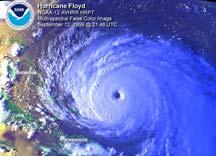
1 Image courtesy of USGS Image courtesy of NOAA. The Science and Policy of Natural Hazards Image courtesy of USGS. Image courtesy of NOAA.
2 Topics Four categories of hazards will be investigated in this class, as part of the following modules: Module 1 (9 classes): Module 2 (9 classes): Module 3 (11 classes): Module 4 (8 classes): Earthquakes (SR) Tornadoes and severe weather (KAE) Volcanoes (SR) Hurricanes (KAE) We will address the following aspects of each hazard category (when applicable): 1. Phenomenology 7. Adaptation 2. Physics 8. Public Policy 3. Forecasting a. Building codes 4. Economics b. Insurance regulation 5. Hazard risk assessment c. Federal insurance 6. Mitigation d. Evacuation e. Reconstruction
3 Course Structure Each module will have an associated problem set Term project will involve a comprehensive risk assessment for a particular location
4 Overview of Natural Hazards
5 2008 Disasters This image has been removed due to copyright restrictions.
6 This image has been removed due to copyright restrictions.
7 Trends in Natural Disasters This image has been removed due to copyright restrictions.
8 This image has been removed due to copyright restrictions.
9 Types of Disasters This image has been removed due to copyright restrictions.
10
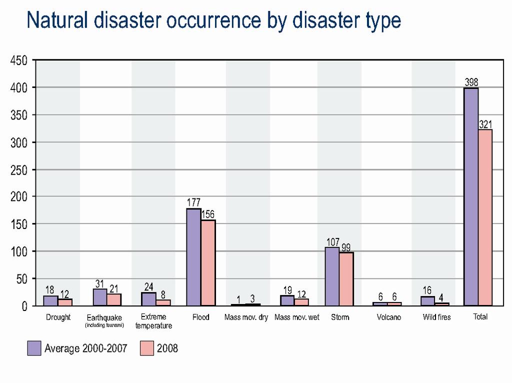
11 Press Release 22 January 2009 Deaths and economic losses jump in 2008 Geneva 2008 saw a marked increase in the number of deaths and economic losses compared to the yearly average. The Center for Research on Epidemiology of Disasters (CRED) released disaster figures for 2008 today in Geneva at a joint press conference with the UnitedNations International Strategy for Disaster Reduction (UNISDR) Secretariat.
12 In 2008, 321 disasters killed 235,816 people, affected 211 million others and cost a total of US$181 billion. Asia remained the main affected continent. Nine of the top 10 countries with the highest number of disaster-related deaths were in Asia. The death toll in 2008 was three times more than the annual average of 66,812 for and was mainly caused by two major events: Cyclone Nargis which killed 138,366 people in Myanmar and the Sichuan earthquake in China which caused the deaths of 87,476 people. The number of people affected by disasters in 2008 was below the annual average of 231 million. Only 42 million people were affected by floods in 2008 compared to 164 million in Nevertheless, floods remained one of the most frequent disaster events in 2008 along with other weatherrelated disasters.
13 Disaster costs in 2008 were twice the US$81 billion annual average for and mainly attributed to the Sichuan earthquake in China (US$85 billion) and hurricane Ike in the U.S. (US$30 billion). The dramatic increase in human and economic losses from disasters in 2008 is alarming. Sadly, these losses could have been substantially reduced if buildings in China, particularly schools and hospitals, had been built to be more earthquake-resilient. An effective early warning system with good community preparedness could have also saved many lives in Myanmar if it had been implemented before Cyclone Nargis, said Salvano Briceño, Director of UNISDR.
14 U.S. Hazards
, to moderate (blue, green, and yellow), to high")
15 Image courtesy of USGS. This map shows relative shaking hazards in the United States and Puerto Rico. During a 50-year time period, the probability of strong shaking increases from very low (white), to moderate (blue, green, and yellow), to high (orange, pink, and red). Map not to scale.


16 Presidential disaster declarations related to flooding in the United States, shown by county: Green areas represent one declaration; yellow areas represent two declarations; orange areas represent three declarations; red areas represent four or more declarations between June 1, 1965, and June 1, Map not to scale. Sources: FEMA, Michael Baker Jr., Inc., the National Atlas, and the USGS


17 The number of hurricanes expected to occur during a 100-year period based on historical data light blue area, 20 to 40; dark blue area, 40 to 60; red area, more than 60. Map not to scale. Source: the National Atlas and the USGS

18 Landslide potential of the conterminous United States: Red areas have very high potential, yellow areas have high potential, and green areas have moderate potential. Landslides can and do occur in the black areas, but the potential is low. Map not to scale. Sources: the National Atlas and the USGS

19 This map shows seven earthquake-generated tsunami events in the United States from the years 900 to The earthquakes that caused these tsunamis are: Prince William Sound, Alaska, 1964, magnitude 9.2; Chile, 1960, magnitude 9.5; Alaska, 1946, magnitude 7.3; Puerto Rico/Mona Rift, 1918, magnitude 7.3 to 7.5; Virgin Islands, 1867, magnitude undetermined; Cascadia, 1700, magnitude 9; and Puget Sound, 900, magnitude 7.5. Map not to scale. Sources: National Geophysical Data Center, NOAA, USGS
 is responsible for monitoring our Nation's 170 active volcanoes (red triangles) for signs of unrest and for issuing timely warnings of hazardous activity to")
20 Image courtesy of USGS. The U.S. Geological Survey (USGS) is responsible for monitoring our Nation's 170 active volcanoes (red triangles) for signs of unrest and for issuing timely warnings of hazardous activity to government officials and the public. This responsibility is carried out by scientists at the five volcano observatories operated by the USGS Volcano Hazards Program and also by State and university cooperators.

21 This map shows locations that experienced wildlfires greater than 250 acres, from 1980 to Map not to scale. Sources: Bureau of Land Management, U.S. Forest Service, U.S. Fish and Wildlife Service, Bureau of Indian Affairs, National Park Service, and the USGS National Atlas

22 Image courtesy of NOAA.
23 MIT OpenCourseWare Science and Policy of Natural Hazards Spring 2010 For information about citing these materials or our Terms of Use, visit:
5.2. IDENTIFICATION OF NATURAL HAZARDS OF CONCERN
 5.2. IDENTIFICATION OF NATURAL HAZARDS OF CONCERN To provide a strong foundation for mitigation strategies considered in Sections 6 and 9, County considered a full range of natural hazards that could impact
5.2 IDENTIFICATION OF HAZARDS OF CONCERN
 5.2 IDENTIFICATION OF HAZARDS OF CONCERN 2015 HMP Update Changes The 2010 HMP hazard identification was presented in Section 6. For the 2015 HMP update, the hazard identification is presented in subsection
5.2 IDENTIFICATION OF HAZARDS OF CONCERN
 5.2 IDENTIFICATION OF HAZARDS OF CONCERN 2016 HMP Update Changes The 2011 HMP hazard identification was presented in Section 3. For the 2016 HMP update, the hazard identification is presented in subsection
2018 REVIEW OF DISASTER EVENTS
 2018 REVIEW OF DISASTER EVENTS Supplementary Information* BRUSSELS, 24 January, 2019 In 2018, there were 281 climate-related and geophysical events recorded in the EM-DAT (International Disaster Database)
Disaster Risk Management in India. Kamal Kishore New Delhi, 27 October 2016
 Disaster Risk Management in India Kamal Kishore New Delhi, 27 October 2016 Hazard, Exposure and Vulnerability Disaster Prevention Mitigation Hurricane Matthew: Cuba & Haiti Emergency Response Coordination
5.2 IDENTIFICATION OF HAZARDS OF CONCERN
 5.2 IDENTIFICATION OF HAZARDS OF CONCERN 2016 HMP Update Changes The 2011 HMP hazard identification was presented in Section 3. For the 2016 HMP update, the hazard identification is presented in subsection
United States Multi-Hazard Early Warning System
 United States Multi-Hazard Early Warning System Saving Lives Through Partnership Lynn Maximuk National Weather Service Director, Central Region Kansas City, Missouri America s s Weather Enterprise: Protecting
IDENTIFICATION OF HAZARDS OF CONCERN
 IDENTIFICATION OF HAZARDS OF CONCERN To provide a strong foundation for mitigation strategies considered in Section 6, the Village considered a full range of hazards that could impact the area and then
Impact of Cyclone Nargis
 Lessons Learnt from Nargis Recovery for the Next Disaster International Recovery Forum (2011) 12, JAN 2011, Kobe, Japan Home for over 100 national races. Profile of Myanmar The 2 nd largest country in
B.2 Sources for Hazard Identification, Profiling, and Ranking (Section 3) Overview of Sussex County s History of Hazards
 Overview of Sussex County s History of Hazards") Appendix B Sources B.1 Sources for Planning Process (Section 2) FEMA. Mitigation Planning Guidance (386 Series). Available on the web at: http://www.fema.gov/plan/mitplanning/planning_resources.shtm FEMA
Appendix B Sources B.1 Sources for Planning Process (Section 2) FEMA. Mitigation Planning Guidance (386 Series). Available on the web at: http://www.fema.gov/plan/mitplanning/planning_resources.shtm FEMA
Hazardous Weather and Flooding Preparedness. Hazardous Weather and Flooding Preparedness
 Hazardous Weather and Flooding Preparedness 1 A Cooperative Effort 2 Administrative Information Emergency exits and procedures Location of restrooms Mobile devices Procedure for questions Course materials
5.2 IDENTIFICATION OF NATURAL HAZARDS OF CONCERN
 5.2 IDENTIFICATION OF NATURAL HAZARDS OF CONCERN To provide a strong foundation for mitigation strategies considered in Sections 6 and 9, County considered a full range of natural s that could impact area,
2017 Hurricane Season and Beyond
 2017 Hurricane Season and Beyond Ken Graham National Hurricane Center Building a Weather-Ready Nation Much of U.S. Coast Saw Tropical Wind Watches or Warnings 2017 Hurricane Season Facts and Figures 7th
Global Map: A Tool for Disaster Mitigation for the Asia and Pacific Region
 Global Map: A Tool for Disaster Mitigation for the Asia and Pacific Region D. R. Fraser Taylor Chair, International Steering Committee for Global Mapping (ISCGM) fraser_taylor@carleton.ca www. 18 th United
Summary of Available Datasets that are Relevant to Flood Risk Characterization
 Inter-Agency Characterization Workshop February 25-27, 2014 USACE Institute for Water Resources, Alexandria, VA, IWR Classroom Summary of Available Datasets that are Relevant to Characterization National
Oregon APA Legal Issues Workshop December 7, Tricia Sears, DLCD With information from Bill Burns, DOGAMI
 Oregon APA Legal Issues Workshop December 7, 2018 Tricia Sears, DLCD With information from Bill Burns, DOGAMI How this Topic Arrived WE FREQUENTLY HEAR CONCERNS ABOUT LIABILITY AND TAKINGS. Current federal
5.2 IDENTIFICATION OF HAZARDS OF CONCERN
 5.2 IDENTIFICATION OF HAZARDS OF CONCERN To provide a strong foundation for mitigation actions considered in Sections 6 and 9, County focused on considering a full range of s that could impact area, and
Smart use of Geographic Information System (GIS) platform for delivering weather information and nowcasting services
 platform for delivering weather information and nowcasting services") Smart use of Geographic Information System (GIS) platform for delivering weather information and nowcasting services C. K. Pan Hong Kong Observatory Hong Kong, China It is a world of beauty Source: Image
Smart use of Geographic Information System (GIS) platform for delivering weather information and nowcasting services C. K. Pan Hong Kong Observatory Hong Kong, China It is a world of beauty Source: Image
Tectonic Processes and Hazards Enquiry Question 1: Why are some locations more at risk from tectonic hazards?
 Tectonic Processes and Hazards Enquiry Question 1: Why are some locations more at risk from tectonic hazards? Key words Basalt Andesite Rhyolite Benioff Zone Subduction zone Crustal fracturing Definition
They include earthquakes, volcanic eruptions, floods, landslides, and other processes and occurrences. They are included in the broader concept of.
 They include earthquakes, volcanic eruptions, floods, landslides, and other processes and occurrences. They are included in the broader concept of. In general, natural processes are labeled hazardous only
Baldwin County, Alabama
 2015 Baldwin County, Alabama Multi-Hazard Mitigation Plan I. Comprehensive Plan A multi-jurisdiction plan City of Bay Minette City of Daphne Town of Elberta City of Fairhope City of Foley City of Gulf
4.1 Hazard Identification: Natural Hazards
 data is provided in an annex, it should be assumed that the risk and potential impacts to the affected jurisdiction are similar to those described here for the entire Sacramento County Planning Area. This
Coping With Disaster: The Impact of Hurricanes on International Financial Flows,
 Coping With Disaster: The Impact of Hurricanes on International Financial Flows, 1970-2001 Dean Yang Gerald R. Ford School of Public Policy University of Michigan 1 Motivation Disasters cause huge human
How to communicate Cascadia Subduction Zone earthquake hazards
 How to communicate Cascadia Subduction Zone earthquake hazards Tom Brocher Research Geophysicist Earthquake Science Center U.S. Geological Survey Menlo Park, California Seattle Post-Intelligencer Lessons
Initiative. Country Risk Profile: papua new guinea. Better Risk Information for Smarter Investments PAPUA NEW GUINEA.
 Pacific Catastrophe Risk Assessment And Financing Initiative PAPUA NEW GUINEA September 211 Country Risk Profile: papua new is expected to incur, on average, 85 million USD per year in losses due to earthquakes
The Nuts and Bolts of These Community Preparedness Recognition Programs
 The Nuts and Bolts of These Community Preparedness Recognition Programs Bill Sammler Warning Coordination Meteorologist NOAA s National Weather Service, Wakefield VA http://weather.gov/akq Why is StormReady
Activities and Outlook related to Disaster Reduction in CMA
 Activities and Outlook related to Disaster Reduction in CMA WANG Bangzhong China Meteorological Administration March 15-17 2006 ADENDA Situation about MD and related disasters in CHINA Guidance for MD/RD
Pacific Catastrophe Risk Assessment And Financing Initiative
 Pacific Catastrophe Risk Assessment And Financing Initiative PALAU September is expected to incur, on average,.7 million USD per year in losses due to earthquakes and tropical cyclones. In the next 5 years,
NOAA s National Weather Service. National Weather Service
 NOAA s National Weather Service Serving the Nation s Environmental Forecasting Needs Lynn Maximuk Regional Director National Weather Service Central Region Headquarters Kansas City, Missouri America s
Pacific Catastrophe Risk Assessment And Financing Initiative
 Pacific Catastrophe Risk Assessment And Financing Initiative TIMOR-LESTE September Timor-Leste is expected to incur, on average, 5.9 million USD per year in losses due to earthquakes and tropical cyclones.
A GEOGRAPHIC ASSESSMENT OF MAJOR DISASTER DECLARATIONS ACROSS THE LOWER 48 STATES
 A GEOGRAPHIC ASSESSMENT OF MAJOR DISASTER DECLARATIONS ACROSS THE LOWER 48 STATES A summary report produced by the Southern Climate Impacts Planning Program (SCIPP) Author: James Hocker Southern Climate
Earthquake Hazards. Tsunami
 Earthquake Hazards Tsunami Measuring Earthquakes Two measurements that describe the power or strength of an earthquake are: Intensity a measure of the degree of earthquake shaking at a given locale based
Monitoring and Warning Systems for Natural Phenomena The Mexican Experience
 Sistema Nacional de Protección Civil Monitoring and Warning Systems for Natural Phenomena The Mexican Experience Roberto Quaas W, Enrique Guevara O. O Mexican National Center for Disaster Prevention CENAPRED
Daily Operations Briefing. Saturday, May 13, :30 a.m. EDT
 Daily Operations Briefing Saturday, May 13, 2017 8:30 a.m. EDT Significant Activity May 12-13 Significant Events: None Significant Weather: Flash Flooding possible Northern NJ and New York City Fire Weather:
Word Cards. 2 map. 1 geographic representation. a description or portrayal of the Earth or parts of the Earth. a visual representation of an area
 Name: Date: Hour: Word Cards 1 geographic representation a description or portrayal of the Earth or parts of the Earth Example: A map is a representation of an actual location or place. 2 map a visual
Building earthquake early warning for the west coast. Ken Creager Professor of Earth and Space Sciences University of Washington
 Building earthquake early warning for the west coast Ken Creager Professor of Earth and Space Sciences University of Washington How Earthquake Early Warning works: P-waves S-waves 3-fold way of Earthquake
Local Weather History
 Local Weather History 52 40- to 2+ 50-minute sessions ACTIVITY OVERVIEW P RO J E C T Students design and conduct a survey to learn about the history of weather disasters in the local area, and then compare
FLOODING. Flood any relatively high stream flow overtopping the natural or artificial banks in a water system.
 CATASTROPHIC EVENTS FLOODING Flood any relatively high stream flow overtopping the natural or artificial banks in a water system. Common Causes: Long-lasting rainfall over a broad area Locally intense
DEPARTMENT OF GEOLOGY AND MINERAL INDUSTRIES WAYS & MEANS SUBCOMMITTEE ON NATURAL RESOURCES MARCH 2, 2017
 DEPARTMENT OF GEOLOGY AND MINERAL INDUSTRIES WAYS & MEANS SUBCOMMITTEE ON NATURAL RESOURCES MARCH 2, 2017 1 ABOUT DOGAMI AGENCY MISSION, VISION & GOALS 2 Lidar image of a stream network along the Umpqua
Running Head: HAZARD MITIGATION PLAN OUTLINE FOR MISSISSIPPI 1
 Running Head: HAZARD MITIGATION PLAN OUTLINE FOR MISSISSIPPI 1 Hazard Mitigation Plan Outline for Mississippi Name: Institution: HAZARD MITIGATION PLAN OUTLINE FOR MISSISSIPPI 2 Hazard Mitigation Plan
WMO Statement on the State of the Global Climate Preliminary conclusions for 2018 and WMO Greenhouse Bulletin
 WMO Statement on the State of the Global Climate Preliminary conclusions for 2018 and WMO Greenhouse Bulletin Dr Elena Manaenkova Deputy Secretary General World Meteorological Organisation Statement on
Module 2, Investigation 1: Earthquake Hazards
 Module 2, Investigation 1: Earthquake Hazards Introduction Welcome! In the last module, you assumed the role of a volcanologist and learned how volcanoes are described and monitored. You will now assume
Assessing Hazards and Risk
 Page 1 of 6 EENS 204 Tulane University Natural Disasters Prof. Stephen A. Nelson Assessing Hazards and Risk This page last updated on 07-Jan-2004 As discussed before, natural disasters are produced by
Linkage to the National Program
 Linkage to the National Program Frank González Pacific Marine Environmental Laboratory Seattle, WA Frank González, NOAA TIME Center, PMEL, Seattle, WA NOAA is about FORECASTS and WARNINGS -Hurricanes Sunspots
Lesson 8. Natural Disasters
 Lesson 8 Natural Disasters 1 Reading is NOT a spectator sport! 2 Reading requires active participation! 3 PREDICT Try to figure out what information will come next and how the selection might end. 4 Natural
Overview of Early Warning Systems and the role of National Meteorological and Hydrological Services
 Overview of Early Warning Systems and the role of National Meteorological and Hydrological Services South Africa Second Experts Symposium on Multi-Hazard Early Warning Systems With focus on the Role of
Bistandsprosjekter i Sørøst-Asia
 Bistandsprosjekter i Sørøst-Asia -Sikre liv og verdier Lars R. Hole, Hanneke Luijting, Tor Ivar Mathisen og Kristine Gjesdal September 2017 Norwegian Meteorological Institute Background Ministry of Foreign
DISASTER SCIENCE: UNDERSTANDING HAZARDS AND DISASTERS COURSE SYLLABUS SPRING 2016
 DISASTER SCIENCE: UNDERSTANDING HAZARDS AND DISASTERS COURSE SYLLABUS SPRING 2016 Instructors: Bruce Houghton and Chris Gregg Phone: 956-2561 (B), Email: bhought@soest.hawaii.edu, gregg@etsu.edu POST 703
Natural Disasters in Member Countries (2002 Summary)
") 4.2 Member Countries and their Disaster Characteristics: Table 5: Natural Disasters in Member Countries (2002 Summary) (Country/Disaster Type/Disaster Characteristics) Data Country DisType Count of TotAff
4.2 Member Countries and their Disaster Characteristics: Table 5: Natural Disasters in Member Countries (2002 Summary) (Country/Disaster Type/Disaster Characteristics) Data Country DisType Count of TotAff
Business Preparedness and Hurricane Risk
 Business Preparedness and Hurricane Risk Hurricanes are one of the more predictable natural disasters compared to events such as earthquakes, wildfires and tornadoes. Meteorologists gather data to predict
Best Practices Natural Disasters Action Plan
 Best Practices Natural Disasters Action Plan MODERATORS: Jeannie Chiaromonte, CAR Vice President / National Remarketing Manager Bank of America Chuck Novince, CAR Vice President National Accounts Manheim
Trends of Natural Disasters in the Asia- Pacific Region and the Direction of Disaster Management
 2016 APEC SCCC, Arequipa, Peru Session 6 - Human Security: Food, Health, Natural Disasters and Environmental Issues Trends of Natural Disasters in the Asia- Pacific Region and the Direction of Disaster
Growth of International Collaboration in Monitoring Volcanic Ash Eruptions in the North Pacific
 Growth of International Collaboration in Monitoring Volcanic Ash Eruptions in the North Pacific John C. Eichelberger and Christina Neal U.S. Geological Survey U.S. Department of the Interior U.S. Geological
Natural Processes. Were you prepared for the fast approaching storm? Were you able to take shelter? What about pets, livestock or plants?
 Have you ever been caught in a storm? You are outside on a summer night and all of a sudden here come the wind, lightning and heavy rain. It starts raining so hard that you can hardly see in front of you.
NATURAL HAZARDS MODULE
 NATURAL HAZARDS MODULE Table of Content Vocabulary... 86 Background Infromation... 87 Introduction... 89 Group activity... 90 Worksheets: Oral history... 93 Written history... 95 Mordern planning... 96
Earthquake Hazards. Tsunami
 Earthquake Hazards Tsunami Review: What is an earthquake? Earthquake is the vibration (shaking) and/or displacement of the ground produced by the sudden release of energy. The point inside the Earth where
Geology 101: Earth Processes and Environment
 1 Course Introduction 2 Geology 101: Earth Processes and Environment Syllabus & overview of topics The big challenges Why Geology Matters Dr. Steve Kuehn What is environmental geology? Major Earth systems
Natural Disasters & Assessing Hazards and Risk. Natural Hazards and Natural Disasters
 Page 1 of 9 EENS 3050 Tulane University Natural Disasters Prof. Stephen A. Nelson Natural Disasters & Assessing Hazards and Risk This page last updated on 09-Jan-2018 Natural Hazards and Natural Disasters
Cyber Enabled Earth Exploration (CE )
") Cyber Enabled Earth Exploration 3 (CE ) Field Notebook Module 2: Introduction to Earthquakes Investigation 1: Earthquake Hazards Table of Contents Folder 1: Describing Earthquakes... 3 Folder 2: Shaanxi,
Cyber Enabled Earth Exploration 3 (CE ) Field Notebook Module 2: Introduction to Earthquakes Investigation 1: Earthquake Hazards Table of Contents Folder 1: Describing Earthquakes... 3 Folder 2: Shaanxi,
US/Global Natural Catastrophe Update
 US/Global Natural Catastrophe Update NAIC's CIPR Symposium on Implications of Increasing Catastrophe Volatility on Insurers Carl Hedde, SVP, Head of Risk Accumulation Munich Reinsurance America, Inc. Source:
Pacific Catastrophe Risk Assessment And Financing Initiative
 Pacific Catastrophe Risk Assessment And Financing Initiative VANUATU September 211 Country Risk Profile: VANUATU is expected to incur, on average, 48 million USD per year in losses due to earthquakes and
Tsunami Research and Its Practical Use for Hazard Mitigation. Hiroo Kanamori Seismological Laboratory, California Institute of Technology
 Tsunami Research and Its Practical Use for Hazard Mitigation Hiroo Kanamori Seismological Laboratory, California Institute of Technology Cause of Tsunami Earthquakes Landslides Volcanic origin Impact (Dr.
HAZARD IDENTIFICATION... 1 HAZARD EFFECTS OF CLIMATE CHANGE... 2 OVERVIEW OF HAZARD ANALYSIS... 4 BUILDING VALUES... 5 POTENTIAL DOLLAR LOSSES...
 R ISK OVERVIEW IDENTIFICATION... 1 EFFECTS OF CLIMATE CHANGE... 2 OVERVIEW OF ANALYSIS... 4 BUILDING VALUES... 5 POTENTIAL DOLLAR LOSSES... 7 IDENTIFICATION This section begins the risk assessment, which
Pacific Catastrophe Risk Assessment And Financing Initiative
 Pacific Catastrophe Risk Assessment And Financing Initiative TUVALU is expected to incur, on average,. million USD per year in losses due to earthquakes and tropical cyclones. In the next 5 years, has
Miami-Dade County Overview
 Miami-Dade County Overview 2,000 square miles World s busiest cruise port 2.6 million residents Second busiest US airport for international travelers Gateway to the Caribbean and Latin America Natural
Enhancing Preparedness and Early Warning in Disaster Risk Reduction
 Enhancing Preparedness and Early Warning in Disaster Risk Reduction Fifth Technical Conference on Management of Meteorological and Hydrological Services in Regional Association V at PETALING JAYA, MALAYSIA
The Inevitability and Consequences of Mega-Disasters in a Crowded World
 The Inevitability and Consequences of Mega-Disasters in a Crowded World John J. Clague Centre for Natural Hazard Research Simon Fraser University NOAA Katrina 2005 Outline Hazard, risk, disasters, and
West Carroll Parish Hazard Mitigation Plan Update Public Meeting. August 25, 2015 Oak Grove, LA
 West Carroll Parish Hazard Mitigation Plan Update Public Meeting August 25, 2015 Oak Grove, LA Agenda Hazard Mitigation Planning Process SDMI Staff Risk Assessment SDMI Staff Update on Previous/Current
GIS DISASTER MAPPING TO UPDATE WARNING SYSTEMS
 POSTER SESSIONS 309 GIS DISASTER MAPPING TO UPDATE WARNING SYSTEMS UTEJ. DYMON DEPT. OF GEOGRAPHY KENT STATE UNIVERSITY KENT, OHIO 44242-0001, USA DYMON@HUMBOLDT.KENT.EDU FAX (216) 672-4304 ABSTRACT The
History of International Training in Seismology and Earthquake Engineering at IISEE
 History of International Training in Seismology and Earthquake Engineering at IISEE Activities of International Institute of Seismology and Earthquake Engineering (IISEE), BRI - Training for young researchers/engineers
New USGS Maps Identify Potential Ground- Shaking Hazards in 2017
 New USGS Maps Identify Potential Ground- Shaking Hazards in 2017 New USGS Maps Identify Potential Ground-Shaking Hazards in 2017 The central U.S. faces continued hazards from human-induced earthquakes
LECTURE #15: Thunderstorms & Lightning Hazards
 GEOL 0820 Ramsey Natural Disasters Spring, 2018 LECTURE #15: Thunderstorms & Lightning Hazards Date: 1 March 2018 (lecturer: Dr. Shawn Wright) I. Severe Weather Hazards focus for next few weeks o somewhat
Session III: Geohazards - Minimizing Risk, Maximizing Awareness. Grand Challenges on Natural and Human-induced Hazards and Disasters
 Session III: Geohazards - Minimizing Risk, Maximizing Awareness Grand Challenges on Natural and Human-induced Hazards and Disasters Sospeter Muhongo s.muhongo@icsu-africa.org www.icsu-africa.org IYPE-Global
Flash Flood in Myanmar
 Flash Flood in Myanmar Presented by : Su Nandar Myint (Ms.) Staff Officer Emergency Operation Center Department of Disaster Management 26 th February 2018 Multi Hazard Early Warning Center, DMH Contents
CapacityAssessmentofNational MeteorologicalandHydrological ServicesinSupportof DisasterRiskReduction
 CapacityAssessmentofNational MeteorologicalandHydrological ServicesinSupportof DisasterRiskReduction Analysisofthe2006WMO DisasterRiskReduction Country-levelSurvey Capacity Assessment of National Meteorological
Daily Operations Briefing. Monday, April 2, :30 a.m. EDT
 Daily Operations Briefing Monday, April 2, 2018 8:30 a.m. EDT Significant Activity Mar 31-April 2 Significant Events: None Tropical Activity: No significant activity Significant Weather: Heavy Snow Northern
Daily Operations Briefing. Friday, November 10, :30 a.m. EST
 Daily Operations Briefing Friday, November 10, 2017 8:30 a.m. EST Significant Activity Nov 9-10 Significant Events: None Tropical Activity: Atlantic No tropical cyclones expected next 48 hours Eastern
Disclaimer. This report was compiled by an ADRC visiting researcher (VR) from ADRC member countries.
 from ADRC member countries.") Disclaimer This report was compiled by an ADRC visiting researcher (VR) from ADRC member countries. The views expressed in the report do not necessarily reflect the views of the ADRC. The boundaries and
Disclaimer This report was compiled by an ADRC visiting researcher (VR) from ADRC member countries. The views expressed in the report do not necessarily reflect the views of the ADRC. The boundaries and
Tornado Hazard Risk Analysis: A Report for Rutherford County Emergency Management Agency
 Tornado Hazard Risk Analysis: A Report for Rutherford County Emergency Management Agency by Middle Tennessee State University Faculty Lisa Bloomer, Curtis Church, James Henry, Ahmad Khansari, Tom Nolan,
Surviving the Big One: Understanding and Preparing for a Major Earthquake in Western Oregon
 Surviving the Big One: Understanding and Preparing for a Major Earthquake in Western Oregon May 21, 2013 City of Salem Salem Public Library Althea Rizzo, Geological Hazards Program Coordinator Oregon Emergency
Lecture 1: Population and Sustainability Key Questions
 Lecture 1: Population and Sustainability Key Questions 1. How is the population growth rate determined? 2. What is an exponential growth rate? 3. Is the population currently rising exponentially? 4. What
June 2-5, 2018 Pasadena, CA Pasadena Convention Center. #aphl
 June 2-5, 2018 Pasadena, CA Pasadena Convention Center #aphl Florida s Response to Natural Disasters Andrew Cannons, Ph.D. Laboratory Director Bureau of Public Health Laboratories (BPHL)-Tampa Florida
Introduction to Environmental Geology, 5e Case History: Indonesian Tsunami Indonesian Tsunami (2) Introduction Historic Tsunamis
 Introduction Historic Tsunamis") 1 2 3 4 5 6 7 8 9 Introduction to Environmental Geology, 5e Chapter 7 Tsunami Case History: Indonesian Tsunami December 26, 2004, within a few hours, close to 250,000 people were killed With no warning
1 2 3 4 5 6 7 8 9 Introduction to Environmental Geology, 5e Chapter 7 Tsunami Case History: Indonesian Tsunami December 26, 2004, within a few hours, close to 250,000 people were killed With no warning
GEOMATICS AND DISASTER MANAGEMENT: Early Impact assessment in Haiti
 GEOMATICS AND DISASTER MANAGEMENT: Early Impact assessment in Haiti We will talk about... Post-disaster response: the main questions to be answered Post-disaster rapid mapping: the role of Geomatics The
Risk-based land use and spatial planning
 Risk-based land use and spatial planning Miho OHARA International Centre for Water Hazards and Risk Management (ICHARM) Public Works Research Institute PWRI), Japan Under the auspices of UNESCO Introduction
Earthquakes down under: a rare but real hazard
 University of Wollongong Research Online Faculty of Science, Medicine and Health - Papers Faculty of Science, Medicine and Health 2015 Earthquakes down under: a rare but real hazard Solomon Buckman University
DRAFT - Tsunami Response Plan Playbook Santa Cruz Harbor Maritime Community
 DRAFT - Tsunami Response Plan Playbook Santa Cruz Harbor Maritime Community Page 1 Best to display on 11X17 paper Purpose and Use of this Real-time Tsunami Response Plan Playbook PURPOSE: This product
1. Impacts of Natural Disasters by Region, 2008
 1. Impacts of Natural Disasters by Region, 2008 Among all regions across the world in 2008, Asia not only ranks first but also dominates in all natural disaster s impact categories occurrence, killed,
STEUBEN COUNTY, NEW YORK. Hazard Analysis Report
 STEUBEN COUNTY, NEW YORK Hazard Analysis Report Prepared by: April 1, 2014 Background On April 1, 2014 the Steuben County Office of Emergency Management conducted a hazard analysis using the automated
FINAL EXAM December 20 th, here at 1:00 3:00 pm
 FINAL EXAM December 20 th, here at 1:00 3:00 pm REVIEW SESSION December 11 th at 6:00-7:30 pm Morrill I Auditorium (Room N375) Same as last time Don t forget your online course evaluations! Major Volcanic
Layers (Layers in italics indicate group layers.) MyHazards MyPlan* Floods and Drought Landslides - USGS
 MyHazards MyPlan* Floods and Drought Landslides - USGS") MyHazards and MyPlan WebApps for Nevada Geohazards Over 100 hazard layers related to floods, fires, earthquakes, radon, and other supporting reference layers. Powerful educational and decision-making tools
MyHazards and MyPlan WebApps for Nevada Geohazards Over 100 hazard layers related to floods, fires, earthquakes, radon, and other supporting reference layers. Powerful educational and decision-making tools
Kentucky Weather Hazards: What is Your Risk?
 Kentucky Weather Hazards: What is Your Risk? Stuart A. Foster State Climatologist for Kentucky 2010 Kentucky Weather Conference Bowling Green, Kentucky January 16, 2010 Perspectives on Kentucky s Climate
Remote sensing and GIS for multi-hazard risk assessments in the coastal zone: recent applications and challenges in the Pacific Jens Kruger
 Remote sensing and GIS for multi-hazard risk assessments in the coastal zone: recent applications and challenges in the Pacific Jens Kruger Geoscience Division Pacific Community (SPC) The First Pacific
LARGE-SCALE INDUSTRIAL SITE SELECTION USING A MINIMUM NATURAL RISK APPROACH CONCEPT AND PROTOTYPIC IMPLEMENTATION. Master Thesis Defence Anne Birckigt
 LARGE-SCALE INDUSTRIAL SITE SELECTION USING A MINIMUM NATURAL RISK APPROACH CONCEPT AND PROTOTYPIC IMPLEMENTATION Master Thesis Defence Anne Birckigt Dresden, Dresden, 23.09.2011 Outline 1. Motivation
Hurricane Readiness for Coastal Communities
 Hurricane Readiness for Participant Guide Developed for: Federal Emergency Management Agency Emergency Management Institute 16825 South Seton Avenue Emmitsburg, MD 21727-8998 Developed by: C² Technologies,
THE INTEGRATED INFORMATION SYSTEM FOR NATURAL
 THE INTEGRATED INFORMATION SYSTEM FOR NATURAL DISASTER MITIGATION Junxiu Wu 1, Qiang Feng 2*, Bijun Liang 3, and Angsheng Wang 4 1 Department of Computer System, Technological Bureau of Xinhua News Agency,
From Vulnerability to Resilience And the Tools to Get There. Out of Harm s Way Partnership for the Delaware Estuary August 1, 2012
 From Vulnerability to Resilience And the Tools to Get There Out of Harm s Way Partnership for the Delaware Estuary August 1, 2012 Today s Presentation Tour of New Jersey Challenges Definitions so we re
WHAT HAPPENS WHEN A TORNADO STRIKES THE COMMUNITY? Carroll County Sheriff s Office Emergency Management
 WHAT HAPPENS WHEN A TORNADO STRIKES THE COMMUNITY? Carroll County Sheriff s Office Emergency Management WHAT IS EMERGENCY MANAGEMENT? Carroll County Sheriff s Office Emergency Management Agency is responsible
Overview of Philippine Geohazards Programs
 Overview of Philippine Geohazards Programs 53 rd CCOP Annual Session CCOP-IUGS Task Group on Geohazards Joint Seminar Cebu City, PHILIPPINES October 18, 2017 Renato U. Solidum, Jr. Department of Science
Remote Sensing to Manage Geohazard Risks
 Remote Sensing to Manage Geohazard Risks Dr Colm Jordan Head: Earth & Planetary Observation & Monitoring Platform Manager: Global Geological Risk September 2016, Lloyds Satellite Remote Sensing for Disaster