Lecture 1: Population and Sustainability Key Questions
|
|
|
- Vernon Booker
- 6 years ago
- Views:
Transcription

1 Lecture 1: Population and Sustainability Key Questions 1. How is the population growth rate determined? 2. What is an exponential growth rate? 3. Is the population currently rising exponentially? 4. What countries have the highest population growth rate? Lowest? 5. Where are population densities with respect to natural hazards? 6. What is sustainability? 7. Is our population and life style sustainable?


2 Environmental geology is the study of the affect of geological processes on society, and how society impacts the Earth Indonesia Tsunami Global Warming change2.jpg


3 The Earth s growing population is spilling into more vulnerable landscape, and requiring more resources. %20North%20Indian%20culture/Giant%20traffic%20jam.jpg
4
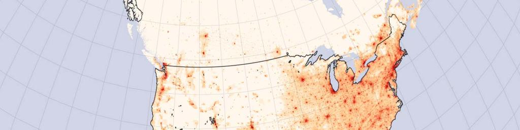
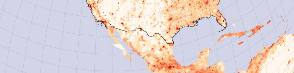
5 Relative distribution of the world s population

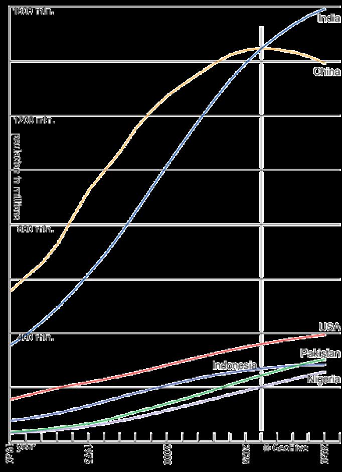
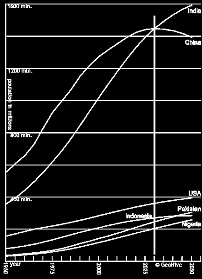
6 Relative distribution of the largest countries


7 Population Density of the World How does the population density relate to plate boundaries?
8 Populations are concentrated in cities Mexico City
 Mexico City http://farm1.static.flickr.com/24/45181212_f642cc839e.jpg")
9 Population densities with respect to geologic hazards 1985 Earthquake (Mag 8.1) Mexico City
 of the world's population lived within 100 km of an historically active")

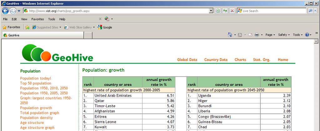
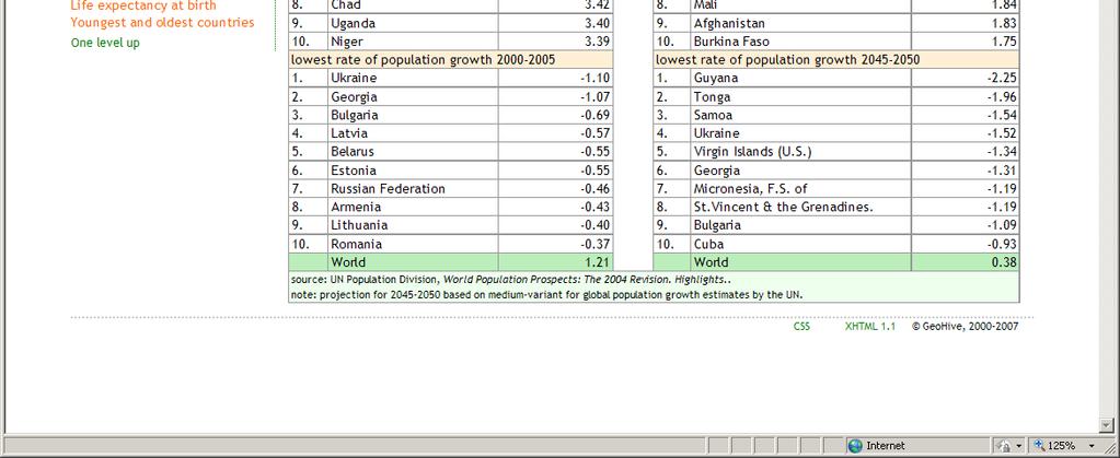
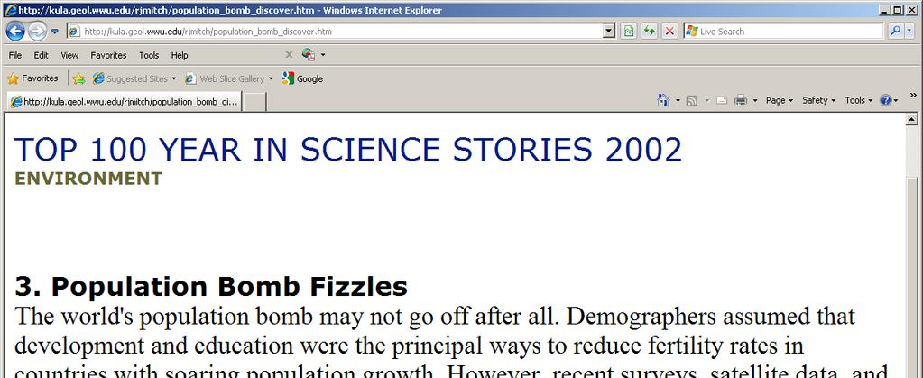
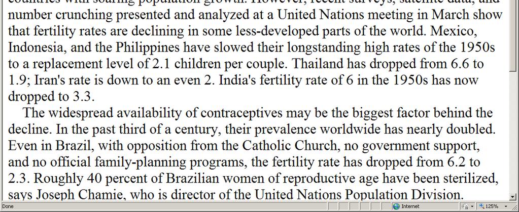
10 Population densities with respect to geologic hazards In 1990 about 8.8% (455 million people) of the world's population lived within 100 km of an historically active volcano. And 12% lived within 100 km of a volcano believed to have been active during the last 10,000 years (the Holocene Epoch). Small, C and T. Naumann. Environmental Hazards, v.3, p ,

11 Volcanoes, earthquakes, and tsunamis in Indonesia
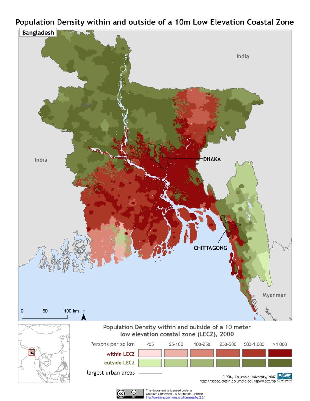
12 Floods in Bangladesh
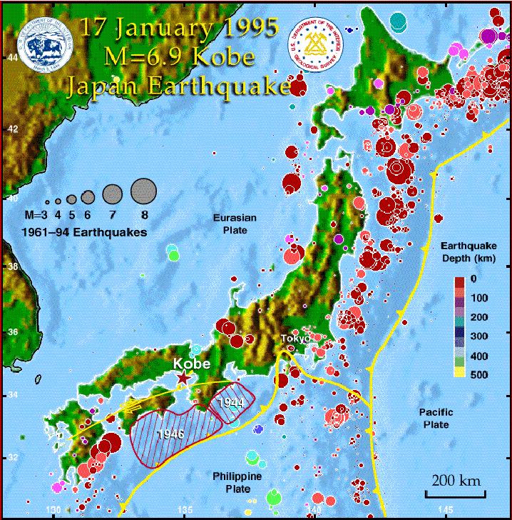
13 Earthqakes in Japan
14

15 Population densities with respect to coastal hazards


16 Washington Population Density (2000) State population: 6,668,200 as of April 1, million people in the Puget Sound

17 Washington Population Density (2000) Major Faults in the Puget Sound 4.1 million people in the Puget Sound

18 Washington Population Density (2000) Seismic Hazards 4.1 million people in the Puget Sound
19 World Population Growth Rate Birth Rate = number of births per 1000 per year (14 in the USA) Death Rate = number of deaths per 100 per year (8 in the USA) Natural Growth Rate = birth rate death rate 14 8 = 6/1000 = or 0.6 % in the USA Due to immigration and emigration the overall growth rate is 0.9% in the USA

20
21
22
23
24 Exponential Growth Rate P = P o e GT P = future population P o = current population G = growth rate (%) T = time in years e = base of the natural logarithm, where ln(e x ) = x
25 Doubling Time Doubling means that: Therefore: P P o = 2 P = P o e GT P P o = e GT 2 = e GT Take the natural log of both sides: ln(2) = GT
26 Doubling Time Take the natural log of 2: ln(2) = or 0.70 Since G is in %, multiply 0.70 by 100: 70 = GT Solve for time (T): T = 70 G
27 Doubling Time The textbook uses D for time, hence: D = 70 G G is the growth rate in %
28
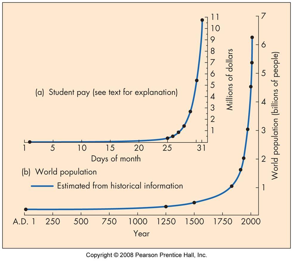
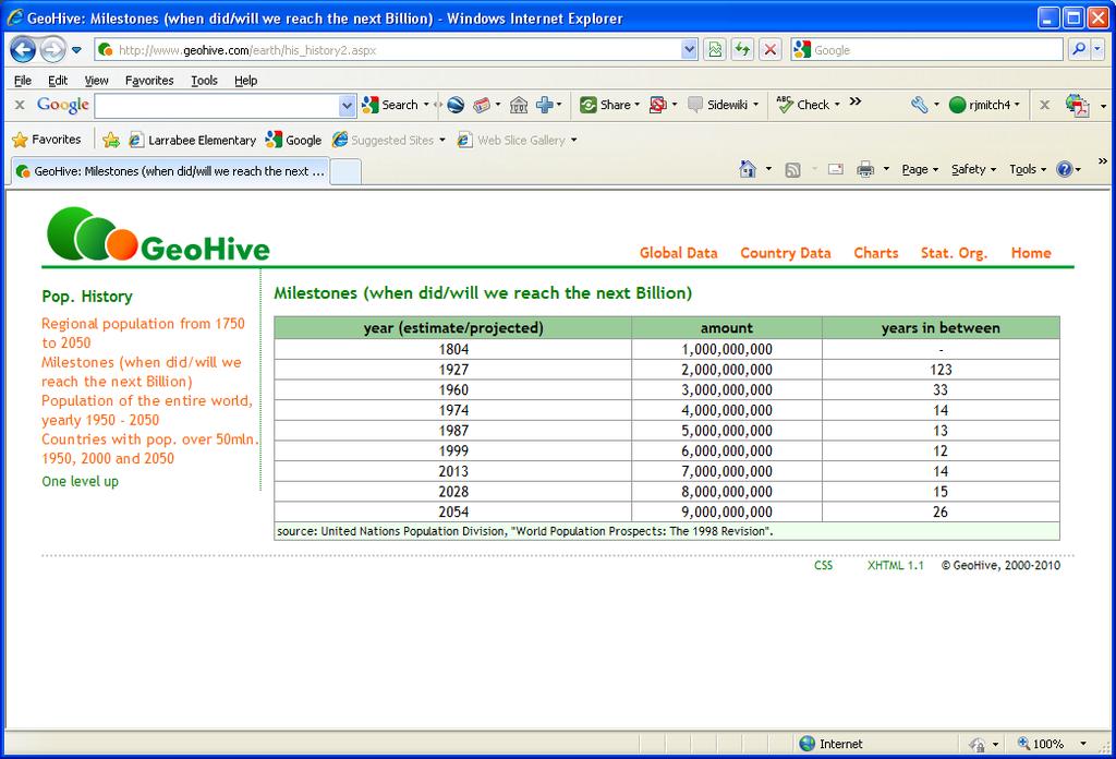
29 Doubling Time For example, the world growth rate is currently 1.13% D = = 62 years Assuming that the world growth rate follows an exponential function, then our current population of billion will double to billion in about 62 years!
30
31 Projected World Population
32
33 Exponential Growth Rate P = P o e GT P = future population P o = current population G = growth rate (%) T = time in years e = base of the natural logarithm, where ln(e x ) = x
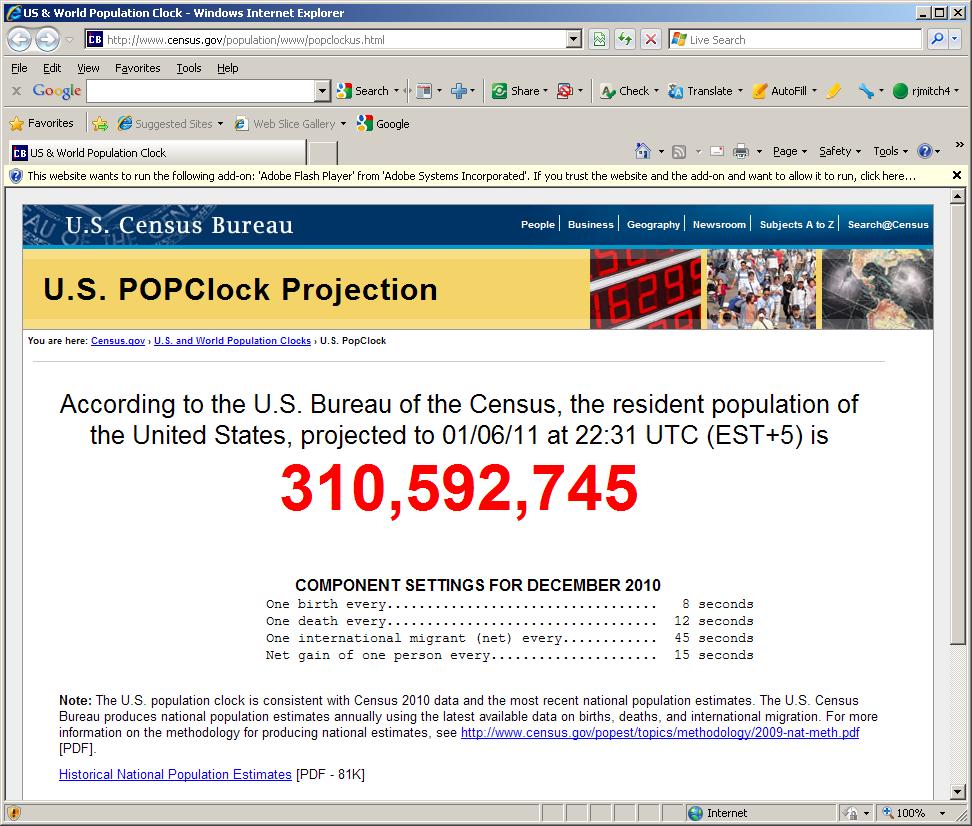
34 Exponential Growth Rate P = P o e GT P = 310,593,000 (current USA population) P o = 268,951,000 (Jan 6, 1998, 13 years ago) T = 13 Solve for G ln(p/p o ) G = = 1.11% 13

35 But, the current USA growth rate is about 0.97%
36
37
38
39


40 If each person on Earth is given 9 square feet to stand on, how much space on Earth would 6.87 billion people take up? 9 sq-ft 3 ft 3 ft
41
42
43
44 6,870,000,000 x 9 = 61,830,000,000 square feet
45 6,870,000,000 x 9 = 61,830,000,000 square feet 5280 x 5280 = 27,878,400 square feet = 1 square mile
46 6,870,000,000 x 9 = 61,830,000,000 square feet 5280 x 5280 = 27,878,400 square feet = 1 square mile 61,830,000,000 27,878,400 = 2218 square miles

47 6,870,000,000 x 9 = 61,830,000,000 square feet 5280 x 5280 = 27,878,400 square feet = 1 square mile 61,830,000,000 27,878,400 = 2218 square miles Whatcom County is 2120 square miles

48 The world s population would fit in Whatcom County!

49 Space isn t the limiting factor for growth.

50 .our impact on the Earth and recourse availability limits growth. ecological footprint

51 Sustainability is the balance between population, economic growth, and the carrying capacity of the Earth Carrying Capacity

52 Sustainable Development Economy Energy recourses Water supplies Cropland and food supplies Waste storage Environmental impacts
53
54
55
56
57
Intermediate Algebra. 8.6 Exponential Equations and Change of Base. Name. Problem Set 8.6 Solutions to Every Odd-Numbered Problem.
 8. Exponential Equations and Change of Base 1. Solving the equation: 3. Solving the equation: 3 x = 5 5 x = 3 x = ln5 x = ln5 ln5 x = x ln5 = x = ln5 1.450 x = ln5 0.82 5. Solving the equation: 7. Solving
1/20/2013. Introduction to Environmental Geology, 5e. Case History: Island of Hispaniola. Earth History. Earth s Place in Space
 Introduction to Environmental Geology, 5e Edward A. Keller Chapter 1 Philosophy and Fundamental Concepts Intro to Geology: summary haiku Here's geology. It's the study of the Earth - complete entity. Lecture
CAPE Unit 1 Module 2 & 3. Topic Specific Objectives Content Explain the main concepts, flows and processes associated with coastal environments
 # Week(s) Wks 1-3 CAPE Unit 1 Module 2 & 3 Topic Specific Objectives Content Explain the main concepts, flows and processes associated with coastal environments Wave formation, structure, types Textbook
What s Shaking in the Barnett Shale? STEP Dallas, August 11, 2015
 What s Shaking in the Barnett Shale? STEP Dallas, August 11, 2015 BSEEC.org @BSEEC Barnett Shale Facts The Barnett Shale was the first energy shale to be developed and therefore is the birthplace of the
Geology 101: Earth Processes and Environment
 1 Course Introduction 2 Geology 101: Earth Processes and Environment Syllabus & overview of topics The big challenges Why Geology Matters Dr. Steve Kuehn What is environmental geology? Major Earth systems
Earthquake Hazards. Tsunami
 Earthquake Hazards Tsunami Measuring Earthquakes Two measurements that describe the power or strength of an earthquake are: Intensity a measure of the degree of earthquake shaking at a given locale based
FLOODING. Flood any relatively high stream flow overtopping the natural or artificial banks in a water system.
 CATASTROPHIC EVENTS FLOODING Flood any relatively high stream flow overtopping the natural or artificial banks in a water system. Common Causes: Long-lasting rainfall over a broad area Locally intense
Earthquakes down under: a rare but real hazard
 University of Wollongong Research Online Faculty of Science, Medicine and Health - Papers Faculty of Science, Medicine and Health 2015 Earthquakes down under: a rare but real hazard Solomon Buckman University
Global Atmospheric Circulation. Past climate change and natural causes. Global climate change and human activity
 GCSE Geography Edexcel B Revision Checklist Paper 1. Global Geographical Issues Topic 1. Hazardous Earth Key Idea I know/ understand The world s climate system Global Atmospheric Circulation Past climate
Environmental Geology
 GEO106 Environmental Geology SF movie Have your clicker ready 1906: San Francisco on fire 1906: San Francisco: a destroyed city 1 1994: Northridge earthquake December 26 th, 2003 Bam earthquake, Iran magnitude
Earthquake Hazards. Tsunami
 Earthquake Hazards Tsunami Review: What is an earthquake? Earthquake is the vibration (shaking) and/or displacement of the ground produced by the sudden release of energy. The point inside the Earth where
San Andreas Movie Can It Happen?
 San Andreas Movie Can It Happen? Learning Objectives (LO) Lecture 14: Faults and Quakes Read: Chapter 10 and 11 Homework #12 due Thursday 12pm What we ll learn today:! 1. Compare strike-slip to dip-slip
The Science and Policy of Natural Hazards
 Image courtesy of USGS. 12.103 Image courtesy of NOAA. The Science and Policy of Natural Hazards Image courtesy of USGS. Image courtesy of NOAA. Topics Four categories of hazards will be investigated in
1 MAR 110 Lecture #1 Introduction to Oceans Hazards SECTION I Volcano, Earthquake, and Tsunami Hazards
 1 MAR 110 Lecture #1 Introduction to Oceans Hazards SECTION I Volcano, Earthquake, and Tsunami Hazards Ocean Basin Rim Hazards - Earthquakes Earthquake-Induced Oil Storage Tank Conflagration Valdez, Alaska.(NG)
Earthquake Hazards. Tsunami
 Earthquake Hazards Tsunami Review: What is an earthquake? Earthquake is the vibration (shaking) and/or displacement of the ground produced by the sudden release of energy. The point inside the Earth where
Is It Safe to Frack Beneath Lake Lewisville?
 Is It Safe to Frack Beneath Lake Lewisville? Jerry Bartz, 2016 Data in this presentation are provisional and subject to revision and released on the condition that the author shall not be held liable for
Physical Geography: Patterns, Processes, and Interactions, Grade 11, University/College Expectations
 Geographic Foundations: Space and Systems SSV.01 explain major theories of the origin and internal structure of the earth; Page 1 SSV.02 demonstrate an understanding of the principal features of the earth
Downloaded from
 GIST OF THE LESSON: General patternsof population distribution in the world, density of population, factors influencing the distribution of population, population growth, trends in population growth, doubling
MILLIONS AND BILLIONS STUDENT WORKSHEET
 MILLIONS AND BILLIONS STUDENT WORKSHEET Name: Date: Problem 1: A) How tall is a stack of a million sheets of paper? B) How tall is a stack of a billion sheets of paper? 1. I would estimate that the height
Erupted and killed approximately 15,000 people 200 years ago
 1 2 3 4 5 6 7 8 Introduction to Environmental Geology, 5e Chapter 8 Volcanic Activity Volcanoes: summary in haiku form A volcano forms. Magma comes to the surface - explodes, if felsic. Case History: Mt.
Studying Populations I
 Exercise 1 Human Adaptation (cultural ecology) Discuss how the regional physical geography influenced the development of unique cultural traits in two distinct areas of the world. GRADE DISTRIBUTION 11
Word Cards. 2 map. 1 geographic representation. a description or portrayal of the Earth or parts of the Earth. a visual representation of an area
 Name: Date: Hour: Word Cards 1 geographic representation a description or portrayal of the Earth or parts of the Earth Example: A map is a representation of an actual location or place. 2 map a visual
Hazards in the Seattle Area. Disaster Questions. Where Were You? Where Were You? Volcanoes St. Helens Adams, Rainier, Glacier, Baker
 Hazards in the Seattle Area Volcanoes St. Helens Adams, Rainier, Glacier, Baker Earthquakes Outer coast Puget Sound (Seattle Fault & others) Tsunami Outer coast Puget Sound (Seattle Fault & others) Disaster
José Luis Palma, William Rose and Rüdiger Escobar Wolf Department of Geological Engineering and Sciences Michigan Technological University
 Assessing the Volcanic Threat of Central American Volcanoes José Luis Palma, William Rose and Rüdiger Escobar Wolf Department of Geological Engineering and Sciences Michigan Technological University Outline
Study Guide and Review - Chapter 7
 Choose a word or term from the list above that best completes each statement or phrase. 1. A function of the form f (x) = b x where b > 1 is a(n) function. exponential growth 2. In x = b y, the variable
(energy loss is greater with longer wavelengths)
") GEOL 0820 Ramsey Natural Disasters Spring, 2018 LECTURE #9: Tsunami Monitoring & Mitigation Date: 8 February 2018 I. Characteristics (con t): shoaling: o process of wave height increase and breaking as
GEOL 0820 Ramsey Natural Disasters Spring, 2018 LECTURE #9: Tsunami Monitoring & Mitigation Date: 8 February 2018 I. Characteristics (con t): shoaling: o process of wave height increase and breaking as
2/25/2013. Volcanoes: summary in haiku form A volcano forms. Magma comes to the surface - explodes, if felsic.
 Introduction to Environmental Geology, 5e Edward A. Keller Chapter 8 Volcanic Activity Volcanoes: summary in haiku form A volcano forms. Magma comes to the surface - explodes, if felsic. Lecture Presentation
RiskCity Training package on the Application of GIS for multi- hazard risk assessment in an urban environment.
 RiskCity Training package on the Application of GIS for multi- hazard risk assessment in an urban environment. Cees van Westen (Westen@itc.nl) & Nanette C. Kingma (Kingma@itc.nl) ITC: Training & Research
Core Curriculum Supplement
 Core Curriculum Supplement Academic Unit / Office EAS Catalog Year of Implementation 2018-2019 Course (Prefix / Number) GEOL / 1370 Core Proposal Request Add to Core Curriculum Course Title Natural Disasters
Natural Disasters & Assessing Hazards and Risk. Natural Hazards and Natural Disasters
 Page 1 of 9 EENS 3050 Tulane University Natural Disasters Prof. Stephen A. Nelson Natural Disasters & Assessing Hazards and Risk This page last updated on 09-Jan-2018 Natural Hazards and Natural Disasters
Introduction to Environmental Geology, 5e
 Lecture Presentation prepared by X. Mara Chen, Salisbury University Introduction to Environmental Geology, 5e Edward A. Keller Chapter 7 Tsunami Case History: Indonesian Tsunami December 26, 2004, within
Capacity Building in Applications of Remote Sensing and GIS for Disaster Management
 Capacity Building in Applications of Remote Sensing and GIS for Disaster Management M.K. Hazarika, L. Samarakoon, N. Senevirathne, J.S.M. Fowze and R. de Silva Project Researcher GeoInformatics Center
1. In the block diagram shown here, which is the oldest rock unit?
 Pre/Post GCI Name (print) 1. In the block diagram shown here, which is the oldest rock unit? 2. Referring to the same diagram as the previous question, which of the labeled rock units is the youngest?
Pacific Catastrophe Risk Assessment And Financing Initiative
 Pacific Catastrophe Risk Assessment And Financing Initiative PALAU September is expected to incur, on average,.7 million USD per year in losses due to earthquakes and tropical cyclones. In the next 5 years,
The Cascading Hazards from Cascadia s Earthquakes
 Tsunamis The Cascading Hazards from Cascadia s Earthquakes Earthquakes (Nisqually earthquake, Seattle, WA) Volcanoes (Mt St Helens eruption, WA) Joan Gomberg gomberg@usgs.gov Landslides (Oso landslide,
Earthquakes. These icons indicate that teacher s notes or useful web addresses are available in the Notes Page.
 Earthquakes These icons indicate that teacher s notes or useful web addresses are available in the Notes Page. This icon indicates the slide contains activities created in Flash. These activities are not
Natural Disasters in Member Countries (2002 Summary)
") 4.2 Member Countries and their Disaster Characteristics: Table 5: Natural Disasters in Member Countries (2002 Summary) (Country/Disaster Type/Disaster Characteristics) Data Country DisType Count of TotAff
4.2 Member Countries and their Disaster Characteristics: Table 5: Natural Disasters in Member Countries (2002 Summary) (Country/Disaster Type/Disaster Characteristics) Data Country DisType Count of TotAff
"The Big One" by sea and not by land
 "The Big One" by sea and not by land By Los Angeles Times, adapted by Newsela staff on 03.24.14 Word Count 629 Surfer Lee Johnson emerges from the water at San Onofre State Beach, Calif., with the twin
Orting Community College Proposal
 Orting Community College Proposal Cedric, Celina, Francine, Sarah, Samuel GEO CORP Located in Washington, 42 miles south of Seattle. Situated between two rivers on fertile plains. Built on lahar deposits.
Chapter 53 POPULATION ECOLOGY
 Ch. 53 Warm-Up 1. Sketch an exponential population growth curve and a logistic population growth curve. 2. What is an ecological footprint? 3. What are ways that you can reduce your ecological footprint?
Pacific Catastrophe Risk Assessment And Financing Initiative
 Pacific Catastrophe Risk Assessment And Financing Initiative TIMOR-LESTE September Timor-Leste is expected to incur, on average, 5.9 million USD per year in losses due to earthquakes and tropical cyclones.
Pacific Catastrophe Risk Assessment And Financing Initiative
 Pacific Catastrophe Risk Assessment And Financing Initiative VANUATU September 211 Country Risk Profile: VANUATU is expected to incur, on average, 48 million USD per year in losses due to earthquakes and
Debris Avalanches. Debris avalanche deposits on a volcano in Chile. All of the area in the foreground is buried by a thick debris avalanche.
 Debris Avalanches Volcanoes are not very stable structures. From time to time, they collapse producing large rock and ash avalanches that travel at high speeds down valleys. Collapse maybe caused by an
PHILOSOPHY & FUNDAMENTAL CONCEPTS
 CASE HISTORY - HAITI GEOLOGIC DISASTERS & THE ENVIRONMENT PHILOSOPHY & FUNDAMENTAL CONCEPTS 1.1 INTRODUCTION TO ENVIRONMENTAL GEOLOGY Death Toll 85,000-316,000 Homeless >1,000,000 Haiti Dominican Republic
Introduction to Environmental Geology, 5e Case History: Indonesian Tsunami Indonesian Tsunami (2) Introduction Historic Tsunamis
 Introduction Historic Tsunamis") 1 2 3 4 5 6 7 8 9 Introduction to Environmental Geology, 5e Chapter 7 Tsunami Case History: Indonesian Tsunami December 26, 2004, within a few hours, close to 250,000 people were killed With no warning
1 2 3 4 5 6 7 8 9 Introduction to Environmental Geology, 5e Chapter 7 Tsunami Case History: Indonesian Tsunami December 26, 2004, within a few hours, close to 250,000 people were killed With no warning
We have previously looked at artificial seismograms such as this one here.
 We have previously looked at artificial seismograms such as this one here. S P A realistic Seismic Record Each vertical line = 1 minute Each horizontal line = 15 minutes Seismic station PMM is in Parkfield,
Initiative. Country Risk Profile: papua new guinea. Better Risk Information for Smarter Investments PAPUA NEW GUINEA.
 Pacific Catastrophe Risk Assessment And Financing Initiative PAPUA NEW GUINEA September 211 Country Risk Profile: papua new is expected to incur, on average, 85 million USD per year in losses due to earthquakes
Measuring Disaster Risk for Urban areas in Asia-Pacific
 Measuring Disaster Risk for Urban areas in Asia-Pacific Acknowledgement: Trevor Clifford, Intl Consultant 1 SDG 11 Make cities and human settlements inclusive, safe, resilient and sustainable 11.1: By
Students will be able, using GIS, to locate the largest and most destructive earthquakes;
 Exploring Earthquake Hazards with GIS Laboratory for Introduction to Geophysics, Spring 2007 Prof. Constantin Cranganu Brooklyn College of the City University of New York Learning Objectives: Students
Trends of Natural Disasters in the Asia- Pacific Region and the Direction of Disaster Management
 2016 APEC SCCC, Arequipa, Peru Session 6 - Human Security: Food, Health, Natural Disasters and Environmental Issues Trends of Natural Disasters in the Asia- Pacific Region and the Direction of Disaster
CHAPTER. Population Ecology
 CHAPTER 4 Population Ecology Lesson 4.1 Studying Ecology Ernst Haeckel defined ecology in 1866 as the body of knowledge concerning the economy of nature the total relations of the animal to both its inorganic
Properties of Logarithms
 Warm Up Simplify. 1. (2 6 )(2 8 ) 2 14 2. (3 2 )(3 5 ) 3 3 3 8 3. 4. 4 4 5. (7 3 ) 5 7 15 Write in exponential form. 6. log x x = 1 x 1 = x 7. 0 = log x 1 x 0 = 1 Objectives Use properties to simplify
Earthquakes Physical Geology 2017 Part 1: Exploring Earthquake distributions. Home butto California Earthquakes: 1) 2) 3) above
 2) 3) above") Earthquakes Physical Geology 2017 Adapted from a lab by Jennifer Wenner This lab is designed to give you experience exploring seismicity associated with different plate boundaries. You will examine seismograms
Earthquakes Physical Geology 2017 Adapted from a lab by Jennifer Wenner This lab is designed to give you experience exploring seismicity associated with different plate boundaries. You will examine seismograms
Japan Quake: Why Do Humans Live In Dangerous Places? By Simon Saint
 Japan Quake: Why Do Humans Live In Dangerous Places? By Simon Saint What are some good things that volcanoes do? - Mount Saint Helens; Japan Earthquakes and Volcanoes; Eruptions; Rocks of the countries
Ecology is studied at several levels
 Ecology is studied at several levels Ecology and evolution are tightly intertwined Biosphere = the total living things on Earth and the areas they inhabit Ecosystem = communities and the nonliving material
Important Concepts. Earthquake hazards can be categorized as:
 Lecture 1 Page 1 Important Concepts Monday, August 17, 2009 1:05 PM Earthquake Engineering is a branch of Civil Engineering that requires expertise in geology, seismology, civil engineering and risk assessment.
Math 132. Population Growth: Raleigh and Wake County
 Math 132 Population Growth: Raleigh and Wake County S. R. Lubkin Application Ask anyone who s been living in Raleigh more than a couple of years what the biggest issue is here, and if the answer has nothing
Geothermal Systems: Geologic Origins of a Vast Energy Resource
 Geothermal Systems: Geologic Origins of a Vast Energy Resource Energy From the Earth Energy-Land-Water Connections Speaker Series James E. Faulds, PhD Nevada State Geologist and Professor Nevada Bureau
!!!!! STOP!!!!! What is environmental geology? Earth as a closed system implies nearly everything is cycled, recycled
 What is environmental geology?!!!!! STOP!!!!! Geology Study of rocks and minerals that comprise earth s surface and interior and the natural processes that shape the earth s surface and interior over all
!!!!! STOP!!!!! What is environmental geology?
 !!!!! STOP!!!!! What is environmental geology? Geology Study of rocks and minerals that comprise earth s surface and interior and the natural processes that shape the earth s surface and interior over
0 questions at random and keep in order
 Page 1 of 5 This chapter has 48 questions. Scroll down to see and select individual questions or narrow the list using the checkboxes below. 0 questions at random and keep in order s - (23) Odd Numbered
Coastal Inundation Forecasting Demonstration Project CIFDP. Flood Forecasting Initiative-Advisory Group (FFI-AG 3), Geneva, 5-7 Dec, 2017
, Geneva, 5-7 Dec, 2017") Coastal Inundation Forecasting Demonstration Project CIFDP Flood Forecasting Initiative-Advisory Group (FFI-AG 3), Geneva, 5-7 Dec, 2017 Coastal Flooding & Vulnerable Populations Coastal populations are
Coastal Inundation Forecasting Demonstration Project CIFDP Flood Forecasting Initiative-Advisory Group (FFI-AG 3), Geneva, 5-7 Dec, 2017 Coastal Flooding & Vulnerable Populations Coastal populations are
Identifying the causes and effects of earthquakes
 Science 3 Physical Earth and Space Life LESSON 57 Identifying the causes and effects of earthquakes Lesson Preparation Program Materials Child s Booklet E Exploring the Earth s Structure (pp. 12 13) Optional:
LANDSCAPES LANDSCAPES HUMAN IMPACT. PART II: People and their 4/10/2018. GEOG 101 Part II People and their Physical Environment R E M I N D E R S
 R E M I N D E R S Get study guide from course home page. TEXTBOOK READING FOR EXAM II WEATHER and CLIMATE: Ch. 2 LITHOSPHERE: chapter 3 BIOSPHERE: chapter 4 EARTH RESOURCES: chapter 5 Two required essays
Training System and Information Network for Earthquake Disaster Mitigation. Taiki SAITO. Building Research Institute (BRI)
") 1 Training System and Information Network for Earthquake Disaster Mitigation Taiki SAITO Chief Research Engineer, International Institute of Seismology and Earthquake Engineering (IISEE), Building Research
1 Training System and Information Network for Earthquake Disaster Mitigation Taiki SAITO Chief Research Engineer, International Institute of Seismology and Earthquake Engineering (IISEE), Building Research
Theme 4. Disaster Mitigation and Risk Management
 Theme 4 Disaster Mitigation and Risk Management World Flood Map in 2002 Released by WMO as of August 29 Over 17 million were affected (in more than 80 countries) 3,000 were killed Total damage of over
2/25/2019. Taking the northern and southern hemispheres together, on average the world s population lives 24 degrees from the equator.
 Where is the world s population? Roughly 88 percent of the world s population lives in the Northern Hemisphere, with about half north of 27 degrees north Taking the northern and southern hemispheres together,
GY 111: Physical Geology
 UNIVERSITY OF SOUTH ALABAMA GY 111: Physical Geology Lecture 31: Mountain Building 1: Isostasy and Thrusting Last Time Earthquakes A) Earthquake intensity and magnitude B) Seismographs C) Case Studies
Three Fs of earthquakes: forces, faults, and friction. Slow accumulation and rapid release of elastic energy.
 Earthquake Machine Stick-slip: Elastic Rebound Theory Jerky motions on faults produce EQs Three Fs of earthquakes: forces, faults, and friction. Slow accumulation and rapid release of elastic energy. Three
Please complete the SoW proforma below for all subjects and courses for publication on the Website this summer.
 2014-2015 Curriculum plan proforma for The Causeway School website Subject Geography Year 9 Please complete the SoW proforma below for all subjects and courses for publication on the Website this summer.
1/29/2018 OPENING FOR SPRING 2018 HISTORICAL GEOLOGY 20 LEC M/W 8:00AM 9:0AM, RM 705. Camp in Yosemite National Park May 18, 19 and 20
 ENVIRONMENTAL SCIENCE: The scientific study of our environment as well as our role in it. An interdisciplinary study that examines the role of humans on the earth. It is a physical, biological and social
Geology 101 Study Guide #4
 Geology 101 Study Guide #4 Our last unit is the study of the earthquakes, the Earth s interior and plate tectonics. We live in a region which has been added on to North America through plate tectonics.
NATURAL HAZARDS MODULE
 NATURAL HAZARDS MODULE Table of Content Vocabulary... 86 Background Infromation... 87 Introduction... 89 Group activity... 90 Worksheets: Oral history... 93 Written history... 95 Mordern planning... 96
Globalization, Megacities and Waste Management. Antonis Mavropoulos CEO EPEM SA, ISWA STC Chair
 Globalization, Megacities and Waste Management Antonis Mavropoulos CEO EPEM SA, ISWA STC Chair amavrop@epem.gr Aim and contents Aim To frame megacities within globalization context To outline the challenge
Natural Disasters Spring, LECTURE #8: Earthquake Disasters: Monitoring & Mitigation. Date: 1 Feb 2018 (lecturer: Dr.
 GEOL 0820 Ramsey Natural Disasters Spring, 2018 LECTURE #8: Earthquake Disasters: Monitoring & Mitigation Date: 1 Feb 2018 (lecturer: Dr. Shawn Wright) I. Exam I - Reminder Feb 6 th next class details:
Of topic specific knowledge and understanding To encourage progressive development in 'thinking geographically'
 [August 2012] Content exemplars 1. Broad description of the content: Single paragraph, written with technical precision Content rigour (avoiding generic statements) Identifying the core of essential knowledge
MULTIPLE CHOICE. Choose the one alternative that best completes the statement or answers the question.
 Exam Name MULTIPLE CHOICE. Choose the one alternative that best completes the statement or answers the question. 1) One important feature of the world's population with the most significant future implications
5. What is latitude and longitude? 6. What do we mean by the UK? 2 B: Africa 1. To identify the physical features of Africa
 Geography Year 7 Year 7 Coordinator Mr.LLoyd Topics of Study This Year: Students study a broad range of introductory units that cover key skills and themes that will be developed throughout KS3. Students
Coping With Disaster: The Impact of Hurricanes on International Financial Flows,
 Coping With Disaster: The Impact of Hurricanes on International Financial Flows, 1970-2001 Dean Yang Gerald R. Ford School of Public Policy University of Michigan 1 Motivation Disasters cause huge human
UGRC 144 Science and Technology in Our Lives/Geohazards
 UGRC 144 Science and Technology in Our Lives/Geohazards Session 1 Introduction to Hazards and Disasters Dr. Patrick Asamoah Sakyi Department of Earth Science, UG, Legon College of Education School of Continuing
REVISION: POPULATION ECOLOGY 01 OCTOBER 2014
 REVISION: POPULATION ECOLOGY 01 OCTOBER 2014 Lesson Description In this lesson we revise: Introduction to Population Ecology What s Happening in the Environment Human Population: Analysis & Predictions
Interpretive Map Series 24
 Oregon Department of Geology and Mineral Industries Interpretive Map Series 24 Geologic Hazards, and Hazard Maps, and Future Damage Estimates for Six Counties in the Mid/Southern Willamette Valley Including
Pacific Catastrophe Risk Assessment And Financing Initiative
 Pacific Catastrophe Risk Assessment And Financing Initiative TUVALU is expected to incur, on average,. million USD per year in losses due to earthquakes and tropical cyclones. In the next 5 years, has
A. Evaluate log Evaluate Logarithms
 A. Evaluate log 2 16. Evaluate Logarithms Evaluate Logarithms B. Evaluate. C. Evaluate. Evaluate Logarithms D. Evaluate log 17 17. Evaluate Logarithms Evaluate. A. 4 B. 4 C. 2 D. 2 A. Evaluate log 8 512.
Understanding China Census Data with GIS By Shuming Bao and Susan Haynie China Data Center, University of Michigan
 Understanding China Census Data with GIS By Shuming Bao and Susan Haynie China Data Center, University of Michigan The Census data for China provides comprehensive demographic and business information
Earthquakes. Earthquake Magnitudes 10/1/2013. Environmental Geology Chapter 8 Earthquakes and Related Phenomena
 Environmental Geology Chapter 8 Earthquakes and Related Phenomena Fall 2013 Northridge 1994 Kobe 1995 Mexico City 1985 China 2008 Earthquakes Earthquake Magnitudes Earthquake Magnitudes Richter Magnitude
SEMESTER AT SEA COURSE SYLLABUS
 Voyage: Spring 2014 Discipline: Environmental Science EVSC 3559: Geologic Hazards Division: Upper Faculty Name: Gary Griggs SEMESTER AT SEA COURSE SYLLABUS Pre-requisites: None although previous Earth
I CAN DO sheets Southchurch High School
 Rate your confidence in the following topic content and geographical skills by ticking the appropriate column beside each point: Red = Not confident Yellow = Almost there Green = Confident Changing landscapes
Impact of Cyclone Nargis
 Lessons Learnt from Nargis Recovery for the Next Disaster International Recovery Forum (2011) 12, JAN 2011, Kobe, Japan Home for over 100 national races. Profile of Myanmar The 2 nd largest country in
M-8.1 EARTHQUAKE 87KM SW OF PIJIJIAPAN, MEXICO EXACT LOCATION: N W DEPTH: 69.7KM SEPTEMBER 7, 11:49 PST
 M-8.1 EARTHQUAKE 87KM SW OF PIJIJIAPAN, MEXICO EXACT LOCATION: 15.068 N 93.715 W DEPTH: 69.7KM SEPTEMBER 7, 2017 @ 11:49 PST Photo: Luis Alberto Cruz / AP Photo: Carlos Jasso 1 THE 2017 CHIAPAS MEXICO
Geography Exams. RAG rate The Challenge of Natural Hazards
 Geography Exams You will sit three papers, Paper 1 will last 1 hour 30 minutes and will examine your understanding of The Challenge of Natural Hazards, The Living World and Physical Landscapes in the UK.
THEME 1: Landscape and Physical Processes
 What do I need to know for each topic? THEME 1: Landscape and Physical Processes Identify distinctive landscapes as being upland, lowland, coastal and river. Describe how landscapes can be managed e.g.
Lesson 8. Natural Disasters
 Lesson 8 Natural Disasters 1 Reading is NOT a spectator sport! 2 Reading requires active participation! 3 PREDICT Try to figure out what information will come next and how the selection might end. 4 Natural
Learning Plan 4 Chapter 9
 Learning Plan 4 Chapter 9 Question The population of a country reached 309.5 million people. The total area is 3.25 million square miles. What is the population density for the country? Round to the nearest
GEOGRAPHY DEPARTMENT YEAR PLAN DATE: SEPTEMBER 2016 REVIEW DATE: SEPTEMBER 2017
 Falcons 1.Global Location Learning the lines of latitude, longitude, poles, tilt/ seasons, and physical features (oceans, rivers, mountains) 2 incl. fundamental understanding of the geomorphological examples.
Wainui Beach Management Strategy (WBMS) Summary of Existing Documents. GNS Tsunami Reports
 Summary of Existing Documents. GNS Tsunami Reports") Wainui Beach Management Strategy (WBMS) Summary of Existing Documents GNS Tsunami Reports a) Review of Tsunami Hazard and Risk in New Zealand ( National Risk Report ) b) Review of New Zealand s Preparedness
Wainui Beach Management Strategy (WBMS) Summary of Existing Documents GNS Tsunami Reports a) Review of Tsunami Hazard and Risk in New Zealand ( National Risk Report ) b) Review of New Zealand s Preparedness
Earth History 8/21/2016. Introduction to Environmental Geology GEO-106 Instructor: Calvin K. Prothro; PG. Inception: 4.
 Introduction to Environmental Geology GEO-106 Instructor: Calvin K. Prothro; PG Earth History Inception: 4.6 billion yrs Figure 1.A The planetary densities are consistent with a higher metal and rock content
HOW GEOGRAPHY AND GEOLOGY AFFECT BIOLOGICAL DIVERSITY
 HOW GEOGRAPHY AND GEOLOGY AFFECT BIOLOGICAL DIVERSITY Factors Affecting Extinction Rates Natural Factors Climate change Cataclysmic event (volcano, earthquake) Human Activities Habitat Loss/Fragmentation
ANALYZING CITIES & POPULATION: POPULATION GEOGRAPHY
 ANALYZING CITIES & POPULATION: POPULATION GEOGRAPHY Population Geography Population Geography study of the number, contribution, and distribution of human populations Demography the study of the characteristics
Natural hazards risk factors a card sort
 Student tasks 1. Cut up the cards below. 2. Read all of the risk factors and explanations carefully. Match each risk factor to its correct explanation. 3. Identify and explain which risk factor you feel