Department of Civil & Geological Engineering GEOE Engineering Geology ASSIGNMENT #2
|
|
|
- Clarissa Leonard
- 6 years ago
- Views:
Transcription

1 Department of Civil & Geological Engineering GEOE Engineering Geology ASSIGNMENT #2 Due Date: Hand in to: Friday 24 September, 2010 before 12:30 pm There will be a box outside 1C18 for this assignment The information you ll need for this lab is, for the most part, in the course notes and in the extra reading material posted on the course website but you will need to dig around for some more background information, and you will need to use some engineering judgement to answer some of the questions. 1. Consider the following geologic and stratigraphic features. a) List the 3 oldest geologic features and the 5 youngest and briefly justify your choice. b) If you were searching for a location for a nuclear fuel waste repository, are there any units or formations here that you would either definitely wish to investigate or that you would remove from consideration at the outset? Provide reasons (briefly)?
2 2. Three major rock bodies are exposed in the air photo shown: (i) Metamorphosed sediments (dark grey); (ii) granite (light tones); and (iii) dikes (long, narrow bands of dark-grey tones). (a) Study the contacts between the granite and the dikes, and state which of these features is the youngest. (b) Think about the processes that most likely lead to the formation of the granite bodies and the metamorphosed sediments, then comment on the relative age of these rock bodies. (c) Which is most resistant to weathering; the metamorphic rocks or the granite? Briefly explain your answer. (d) Think about the properties of these types of rocks. How can you explain the presence of so much surface water in this area? (And you re not allowed to explain this based on heavy rainfalls; annual precipitation in this area is not particularly high.)

3 3. The Caribbean Islands are a great place to visit when the prairie winter kicks in. They are also very interesting geologically. The Lesser Antilles forms an arc of islands separating the Atlantic Ocean from the Caribbean Sea. Geologists call this a Volcanic Island Arc, i.e. a curved chain of volcanoes, approx. 530 miles long, between Puerto Rico and Venezuela, where the Caribbean tectonic plate meets the Atlantic plate. Mont Pelée in Martinique is an active volcano which has erupted in the 1790 s, 1850 s and in 1902 (when the City of St. Pierre was devastated) and again in the 1930 s. Other regional volcanoes include Soufrière in Saint-Vincent, La Soufrière in Guadeloupe and the Soufrière Hills in Montserrat. a) List the processes involved in the formation of the islands. What processes are still ongoing today? b) Starting from the deep water depositional environment on either side of the tectonic plate boundary, sketch a large-scale east-west cross-section and label the important features. Think hard about the depositional environments in various depths of water. c) Some of the smaller islands are not volcanic. How are these other islands formed and what rock type are they composed of? Sketch the depositional environment of islands such as Marie- Galante (just south of Guadeloupe) or Antigua. Why do such islands exist?
 volcano la Souffrière with a height almost 1500 masl.")
4 4. Guadeloupe comprises 2 main islands as shown. The two islands, Grande-Terre and Basse- Terre are separated by a narrow channel. Basse-Terre is a volcanic massif; note the inactive (but still smouldering) volcano la Souffrière with a height almost 1500 masl. The prevailing winds (and most of the hurricanes) come from the west, i.e. Grande-Terre is in the lee of Basse- Terre. Given that, what do you expect the easterly island of Grande-Terre is composed of? What differences would result between the two islands in terms of topography, climate, vegetation, agriculture etc. An Agro friend of yours (?!) is an avid rock collector and amateur prospector who knows nothing about geology. He returns from his vacation with a bag of rocks. He shows you his souvenirs and invites you to invest money in a prospecting venture. You see a dark shiny dense rock with what looks like some bornite in it, another sample of black brittle foliated schist with tiny specs of what looks like native gold. And the third sample looks suspiciously like quartz-rich granite. Where do you suspect each of the samples came from? Do you invest? If you did invest, where in Gualdeloupe would you look for each (and why)? There is another smaller island, Marie-Galante located about 30 km to the south of Grande- Terre. This island is made up of two distinct sections each a plateau with a major valley separating them and cutting across the island. Describe (using small sketches as appropriate) the geologic processes that created this island and its current topography.


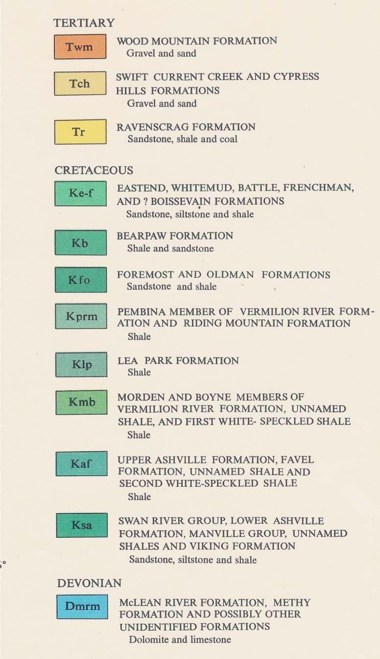
5 5 Using the attached bedrock geology map for Saskatchewan, draw a North-South geological crosssection along the east side of the province near the Manitoba border as shown.
6
PALEOGEOGRAPHY of NYS. Definitions GEOLOGIC PROCESSES. Faulting. Folding 9/6/2012. TOPOGRAPHIC RELIEF MAP of NYS GRADATIONAL TECTONIC
 TOPOGRAPHIC RELIEF MAP of NYS PALEOGEOGRAPHY of NYS Prof. Anthony Grande AFG 2012 Definitions GEOLOGIC PROCESSES Geography: study of people living on the surface of the earth. Geology: the scientific study
1. In the block diagram shown here, which is the oldest rock unit?
 Pre/Post GCI Name (print) 1. In the block diagram shown here, which is the oldest rock unit? 2. Referring to the same diagram as the previous question, which of the labeled rock units is the youngest?
TAKE HOME EXAM 8R - Geology
 Name Period Date TAKE HOME EXAM 8R - Geology PART 1 - Multiple Choice 1. A volcanic cone made up of alternating layers of lava and rock particles is a cone. a. cinder b. lava c. shield d. composite 2.
Structural Geology Lab. The Objectives are to gain experience
 Geology 2 Structural Geology Lab The Objectives are to gain experience 1. Drawing cross sections from information given on geologic maps. 2. Recognizing folds and naming their parts on stereoscopic air
Answers: Internal Processes and Structures (Isostasy)
") Answers: Internal Processes and Structures (Isostasy) 1. Analyse the adjustment of the crust to changes in loads associated with volcanism, mountain building, erosion, and glaciation by using the concept
Answers: Internal Processes and Structures (Isostasy) 1. Analyse the adjustment of the crust to changes in loads associated with volcanism, mountain building, erosion, and glaciation by using the concept
Introduction to Prospecting. Session Two Geology
 Introduction to Prospecting Session Two Geology The Earth Earth is 4.6 billion years old (Ba). Bacteria & algae +3.5 Ba. Microscopic animals ~2 Ba. Animals ~600 million years (Ma) old. Mankind about 100,000
depositional environment = one type of sediment/sedimentary rock = sedimentary structure =
 High School Advanced Geology Exam May 2014 Name: Provide complete short answers to the follow questions. 1. Name one depositional environment for sediment/sedimentary rocks. Name one type of sediment/sedimentary
8 th Earth Science Chapter 4 Rocks Name Section 1 The Rock Cycle:
 8 th Earth Science Chapter 4 Rocks Name Section 1 The Rock Cycle: Most rock used for stone contains one or more common minerals, called rock-forming minerals, such as, feldspar,, or. When you look closely,
Earth s Continents and Seafloors. GEOL100 Physical Geology Ray Rector - Instructor
 Earth s Continents and Seafloors GEOL100 Physical Geology Ray Rector - Instructor OCEAN BASINS and CONTINENTAL PLATFORMS Key Concepts I. Earth s rocky surface covered by of two types of crust Dense, thin,
Module 10: Resources and Virginia Geology Topic 4 Content: Virginia Geology Notes
 Virginia is composed of a very diverse landscape that extends from the beaches and barrier islands all of the way to the highly elevated Appalachian Plateau. Geologists have discovered ancient shallow
GY 112 Lecture Notes Archean Geology
 GY 112 Lecture Notes D. Haywick (2006) 1 GY 112 Lecture Notes Archean Geology Lecture Goals: A) Time frame (the Archean and earlier) B) Rocks and tectonic elements (shield/platform/craton) C) Tectonics
Structural Geology Lab. The Objectives are to gain experience
 Geology 2 Structural Geology Lab The Objectives are to gain experience 1. Drawing cross sections from information given on geologic maps. 2. Recognizing folds and naming their parts on stereoscopic air
Earth Science Lesson Plan Quarter 3, Week 7, Day 1
 Earth Science Lesson Plan Quarter 3, Week 7, Day 1 Outcomes for Today Standard Focus: PREPARE 1. Background knowledge necessary for today s reading. Continental ice sheets increase the weight of the Earth
Ch 9.1 Notes. Objective: Be able to explain the theory of plate tectonics and be able to explain evidence that supports it.
 Ch 9.1 Notes Objective: Be able to explain the theory of plate tectonics and be able to explain evidence that supports it. Pangaea Alfred Wegener proposed that land on Earth formed a single, huge landmass.
Relative Age-dating -- Discovery of Important Stratigraphic Principles
 Roger Steinberg Assistant Professor of Geology Del Mar College 101 Baldwin Corpus Christi, TX 78404 361-698-1665 rsteinb@delmaredu Abstract: When piecing together the geologic history of the Earth, geologists
Benchmark 3 Science Study Guide S6E5 A-Crust, Mantle, Core 1. What happens to the temperature as you travel to the center of the Earth?
 Benchmark 3 Science Study Guide S6E5 A-Crust, Mantle, Core 1. What happens to the temperature as you travel to the center of the Earth? IT GETS HOTTER. 2. What happens to the density as you travel to the
SCIENCE TEST1 (VWILLIAMSSCIENCETEST1)
") Name: Date: 1. In which of the following areas would soil erosion MOST LIKELY occur if they received the same amount of rainfall? A. a forest B. flat agricultural lands C. agricultural lands on steep slopes
Name: Date: 1. In which of the following areas would soil erosion MOST LIKELY occur if they received the same amount of rainfall? A. a forest B. flat agricultural lands C. agricultural lands on steep slopes
Chapter 10. Chapter Rocks and the Rock Cycle. Rocks. Section 1 Rocks and the Rock Cycle
 Chapter 10 Rocks 1 Chapter 10 Section 1 Rocks and the Rock Cycle 2 10.1 Rocks and the Rock Cycle Magma is the parent material for all rocks. Once the magma cools and hardens, many changes can occur. Geology:
Future climate change in the Antilles: Regional climate, tropical cyclones and sea states
 Future climate change in the Antilles: Regional climate, tropical cyclones and sea states Ali Belmadani Météo-France Antilles-Guiana (DIRAG), Martinique Acknowledgements: P. Palany, R. Pilon, F. Chauvin,
24. Ocean Basins p
 24. Ocean Basins p. 350-372 Background The majority of the planet is covered by ocean- about %. So the majority of the Earth s crust is. This crust is hidden from view beneath the water so it is not as
Cambridge International Examinations Cambridge International General Certificate of Secondary Education
 Cambridge International Examinations Cambridge International General Certificate of Secondary Education *4298138811* ENVIRONMENTAL MANAGEMENT 0680/23 Paper 2 October/November 2014 1 hour 45 minutes Candidates
Name Date Class. Directions: Use the diagram below to answer question Florida Progress Monitoring and Benchmark Assessments
 b e n c h m a r k t e s t : e a r t h a n d s p a c e s c i e n c e Multiple Choice 1. Geologists obtain indirect evidence about Earth s interior by A measuring pressure differences at Earth s surface.
OUTCOMES BASED LEARNING MATRIX. Course: Physical Geology Department: _Physical Science. Study the text and lecture material
 OUTCOMES BASED LEARNING MATRIX Course: Physical Geology Department: _Physical Science Physical Geology This course is intended to acquaint students with the physical structure of the Earth, the nature
Geologic Evolution of Latin America. Plate Tectonics: General Concepts & Applications to Latin America
 Geologic Evolution of Latin America Plate Tectonics: General Concepts & Applications to Latin America Structure of Earth: 3 major divisions of Core, Mantle, and Crust Upper mantle differs in the way that
Section 7. Reading the Geologic History of Your Community. What Do You See? Think About It. Investigate. Learning Outcomes
 Chapter 3 Minerals, Rocks, and Structures Section 7 Reading the Geologic History of Your Community What Do You See? Learning Outcomes In this section, you will Goals Text Learning Outcomes In this section,
1. minerals - A naturally occurring substance that takes a solid Crystal form and is made of only a single (one) type of compound
 type of compound") Science Name: Mr. G/Mrs. Kelly KEY Date: Study Guide - Lessons 5 and 6 Test Define the following terms: 1. minerals - A naturally occurring substance that takes a solid Crystal form and is made of only
Science Name: Mr. G/Mrs. Kelly KEY Date: Study Guide - Lessons 5 and 6 Test Define the following terms: 1. minerals - A naturally occurring substance that takes a solid Crystal form and is made of only
Refer to the map on page 173 to answer the following questions.
 Chapter 8-1 Plate Tectonics 1. Brainstorm the type of evidence that would indicate a climate change and how this evidence supports the theory of continental drift. Tropical fossils in cold regions Evidence
LAB 6: TRINIDAD BEACH FIELD TRIP
 OBJECTIVES: LAB 6: TRINIDAD BEACH FIELD TRIP 1) to develop your powers of observation, especially of geological phenomena; 2) to identify the rocks exposed at Trinidad Beach; 3) to reconstruct some of
GEOL 02: Historical Geology Lab 14: Topographic Maps. Name: Date:
 GEOL 02: Historical Geology Lab 14: Topographic Maps Name: Date: A topographic map is a two dimensional (flat) representation (model) of a three dimensional land surface (landscape). It shows landforms
Rocks don't form into the three types of rocks and stay there. The Earth is constantly changing and in motion. The rock cycle demonstrates how a rock
 Rocks don't form into the three types of rocks and stay there. The Earth is constantly changing and in motion. The rock cycle demonstrates how a rock can start out as one type and change into another.
Terrain Units PALEOGEOGRAPHY: LANDFORM CREATION. Present Geology of NYS. Detailed Geologic Map of NYS
 NYS TOPOGRAPHY Why so? PALEOGEOGRAPHY: LANDFORM CREATION Prof. Anthony Grande AFG 014 Present Geology of NYS Detailed Geologic Map of NYS Generalized Geology Detailed Geology Hot links to the fold out
The elevations on the interior plateau generally vary between 300 and 650 meters with
 11 2. HYDROLOGICAL SETTING 2.1 Physical Features and Relief Labrador is bounded in the east by the Labrador Sea (Atlantic Ocean), in the west by the watershed divide, and in the south, for the most part,
LAB: PLATE TECTONICS GOAL: Calculate rates of plate movement
 Name LAB: PLATE TECTONICS GOAL: Calculate rates of plate movement Rates of plate movement are calculated by measuring the distance rocks have moved since they formed. Rates are expressed in cm per year
Science 2015 Earth Science. Study Guide
 Adult Basic Education Level II Science Science 2015 Earth Science Study Guide Resources: Discovering Science 7 Level II Science Courses Science 2011 Life Science Science 2012 Physical Science Science 2013
Name Date Class Benchmark 3 Science Study Guide. Weather & Geology
 Benchmark 3 Science Study Guide Weather & Geology S6E5 A-Crust, Mantle, Core 1. What happens to the temperature as you travel to the center of the Earth? Temperature increases with depth 2. What happens
Type of Exercise: In-Class Activity or Laboratory Exercise.
 Using Lava Flows & Volcanic Structures on Mars to Introduce the Concept of Relative Dating in Introductory Courses Audeliz Matias Skidmore College, Saratoga Springs, NY 12866 amatias@skidmore.edu Type
Changes in Texas Ecoregions Copy the questions and answers
 Changes in Texas Ecoregions Copy the questions and answers 1. What are some kinds of damage that hurricanes cause? Roads and bridges might be washed away. Trees and power lines can be knocked down. Area
Page 1. Name:
 Name: Questions 1 through 3 refer to the following: The diagrams below represent two rock outcrops found several miles apart in New York State. Individual rock layers are lettered, and fossils and rock
NC Earth Science Essential Standards
 NC Earth Science Essential Standards EEn. 2.1 Explain how processes and forces affect the Lithosphere. EEn. 2.1.1 Explain how the rock cycle, plate tectonics, volcanoes, and earthquakes impact the Lithosphere.
UNIT 3 GEOLOGY VOCABULARY FLASHCARDS THESE KEY VOCABULARY WORDS AND PHRASES APPEAR ON THE UNIT 3 CBA
 UNIT 3 GEOLOGY VOCABULARY FLASHCARDS THESE KEY VOCABULARY WORDS AND PHRASES APPEAR ON THE UNIT 3 CBA A map that shows Earth s Topographic Map surface topography, which is Earth s shape and features Contour
Geology 12 FINAL EXAM PREP. Possible Written Response Exam Questions
 Geology 12 FINAL EXAM PREP Possible Written Response Exam Questions Use this study guide to prepare for the written response portion of the final exam. Name FINAL EXAM - POSSIBLE WRITTEN RESPONSE QUESTIONS
Geoscience 001 Fall Rock Identification and Contextual Interpretation
 Geoscience 00 Fall 2005 Rock Identification and Contextual Interpretation The purpose of this week s lab is to gain some more experience and practice in identifying rocks and then interpreting the geologic
Beneath our Feet: The 4 Layers of the Earty by Kelly Hashway
 Beneath our Feet: The 4 Layers of the Earty by Kelly Hashway The Earth is more than a giant ball made up of dirt, rocks, and minerals. The Earth may look like a giant ball from when looking at it from
PHYSICAL GEOGRAPHY: An overview. Definitions. Faulting. Folding GEOLOGIC PROCESSES 9/17/2013 TOPOGRAPHIC RELIEF
 TOPOGRAPHIC RELIEF PHYSICAL GEOGRAPHY: An overview Prof. Anthony Grande AFG 0913 2 Definitions GEOLOGIC PROCESSES Geography: Study of people living on the surface of the earth. Geology: the study of the
USU 1360 TECTONICS / PROCESSES
 USU 1360 TECTONICS / PROCESSES Observe the world map and each enlargement Pacific Northwest Tibet South America Japan 03.00.a1 South Atlantic Arabian Peninsula Observe features near the Pacific Northwest
2. Explain why there are these two predominate elevations. (Hint: think about isostasy and the type of materials we used to demonstrate buoyancy).
.") IDS 102 Plate Tectonics Questions Part I: Observations- Four maps of world are positioned around the room. Answer the questions associated with each map and record your general observations about the maps.
IDS 102 Plate Tectonics Questions Part I: Observations- Four maps of world are positioned around the room. Answer the questions associated with each map and record your general observations about the maps.
Coastal Bedrock Geology, Cape Newagen, Southport
 Maine Geologic Facts and Localities April, 2014, Southport 43 o 47 9 N, 69 o 39 35 W Text by Thomas K. Weddle, Department of Agriculture, Conservation & Forestry 1 Introduction Tourists visiting Maine
Relative Age-dating -- Discovery of Important Stratigraphic Principles Y
 R Steinberg DMC/4-08 EARTH HISTORY 1404 Example 1: Y S P Q Four different rock units (layers of different rock types), labeled Y, S, P, and Q, are seen in a road cut, as shown schematically above: 1) Are
The Geology of Sebago Lake State Park
 Maine Geologic Facts and Localities September, 2002 43 55 17.46 N, 70 34 13.07 W Text by Robert Johnston, Department of Agriculture, Conservation & Forestry 1 Map by Robert Johnston Introduction Sebago
Section 5. Rock Units and Your Community. What Do You See? Think About It. Investigate. Learning Outcomes
 Chapter 3 Minerals, Rocks, and Structures Section 5 Rock Units and Your Community What Do You See? Learning Outcomes In this section, you will Recognize that rocks are arranged in Earth s crust as well-defined
Lecture 26: Marine Geology Read: Chapter 21 Homework due December 3
 Learning Objectives (LO) Lecture 26: Marine Geology Read: Chapter 21 Homework due December 3 What we ll learn today:! 1. Describe the world s five oceans! 2. Understand patterns of ocean circulation! 3.
Geology 101 Lab Worksheet: Geologic Time
 Geology 101 Lab Worksheet: Geologic Time Name: Refer to the Geologic Time Lab for the information you need to complete this worksheet (http://commons.wvc.edu/rdawes/g101ocl/labs/geotimelab.html). All calculations
Statistical analysis of cyclone activity for Guadeloupe. Irina Nikolkina*,**, Narcisse Zahibo*, and Ira Didenkulova***
 Statistical analysis of cyclone activity for Guadeloupe Irina Nikolkina*,**, Narcisse Zahibo*, and Ira Didenkulova*** *Laboratory of Tropical and Atmospheric Physics, University of Antilles Guyane, Guadeloupe
LECTURE 1 - Introduction Hrvoje Tkalčić
 LECTURE 1 - Introduction Hrvoje Tkalčić *** N.B. The material presented in these lectures is from the principal textbooks, other books on similar subject, the research and lectures of my colleagues from
Question #1 Assume that the diagram below shows a cross section of part of the lithosphere.
 Name: Class: Date: Question #1 Assume that the diagram below shows a cross section of part of the lithosphere. Which diagram correctly shows what will happen to the lithosphere when pushed by tectonic
C) use of nuclear power D) number of volcanic eruptions
 use of nuclear power D) number of volcanic eruptions") 3121-1 - Page 1 Name: 1) The graph below shows the change in carbon dioxide concentration in parts per million (ppm) in Earth's atmosphere from 1960 to 1990. The most likely cause of the overall change
3121-1 - Page 1 Name: 1) The graph below shows the change in carbon dioxide concentration in parts per million (ppm) in Earth's atmosphere from 1960 to 1990. The most likely cause of the overall change
General Geology Lab #7: Geologic Time & Relative Dating
 General Geology 89.101 Name: General Geology Lab #7: Geologic Time & Relative Dating Purpose: To use relative dating techniques to interpret geological cross sections. Procedure: Today we will be interpreting
b. atomic mass H What is the density of an object with a volume of 15cm 3 and a mass of 45g?
 Name Period Date Earth Science Midterm Review 2015-2016 Quarter 1 Review Assign #1 Basic Chemistry An atom is a basic chemical building block of matter. An atom consists of protons, neutrons, and electrons.
Sea Floor Spreading Lab ES2 # 2!
 Names & Bl Date your name (first and last) partner Sea Floor Spreading Lab ES2 # 2 Purpose: Show rock age and magnetism patterns in spreading sea floor with a paper model. Background: In the last few decades,
(version 3) I. HumAN -Environment Interaction
 I. HumAN -Environment Interaction") (version 3) I. HumAN -Environment Interaction A. Landforms 1. Earth s topography is made up of many different types of landforms. 2. While the planet is covered primarily with water, the four major types
(version 3) I. HumAN -Environment Interaction A. Landforms 1. Earth s topography is made up of many different types of landforms. 2. While the planet is covered primarily with water, the four major types
OS 1 The Oceans Fall 2007
 Name: Plate Tectonics (you must turn Activities 1-2 in during Section) Activity 1: Plate Boundaries A plate boundary simply describes where two plates (either oceanic or continental material) meet. There
Social Studies 9 UNIT 2 GEOGRAPHIC INFLUENCES ON IDENTITY: PLACE AND PEOPLE
 Social Studies 9 UNIT 2 GEOGRAPHIC INFLUENCES ON IDENTITY: PLACE AND PEOPLE The Structure of the Earth To understand the forces that create Canada's physical landscape we must understand the structure
What type of land feature is located at Point A? A Cliff B Delta C Mountain D Valley
 1 What type of land feature is located at Point A? A Cliff B Delta C Mountain D Valley Alfred Wegener s theory of continental drift was 2 not accepted by scientists when the theory was first proposed.
Pine Hill Serpentinized Peridotite,
 Maine Geologic Facts and Localities November, 2016 Pine Hill Serpentinized Peridotite, Little Deer Isle, Maine 44 o 17 6.0 N, 68 o 42 7.2 W Text and photos by Robert G. Marvinney, Department of Agriculture,
Questions and Topics
 Plate Tectonics and Continental Drift Questions and Topics 1. What are the theories of Plate Tectonics and Continental Drift? 2. What is the evidence that Continents move? 3. What are the forces that
Earth Science Unit 1 Review
 Name: Date: 1. The picture below shows a model of the rock cycle. 2. rock cycle diagram is shown below. During which part of the rock cycle does water break rocks apart?. part 1 B. part 2. part 3 D. part
Which rock is shown? A) slate B) dunite C) gneiss D) quartzite
 slate B) dunite C) gneiss D) quartzite") 1. Which metamorphic rock will have visible mica crystals and a foliated texture? A) marble B) quartzite C) schist D) slate 2. The recrystallization of unmelted material under high temperature and pressure
1. Which metamorphic rock will have visible mica crystals and a foliated texture? A) marble B) quartzite C) schist D) slate 2. The recrystallization of unmelted material under high temperature and pressure
A) B) C) D) 4. Which diagram below best represents the pattern of magnetic orientation in the seafloor on the west (left) side of the ocean ridge?
 B) C) D) 4. Which diagram below best represents the pattern of magnetic orientation in the seafloor on the west (left) side of the ocean ridge?") 1. Crustal formation, which may cause the widening of an ocean, is most likely occurring at the boundary between the A) African Plate and the Eurasian Plate B) Pacific Plate and the Philippine Plate C)
1. Crustal formation, which may cause the widening of an ocean, is most likely occurring at the boundary between the A) African Plate and the Eurasian Plate B) Pacific Plate and the Philippine Plate C)
Soil. Soil in Our Environment
 Soil Soil in Our Environment What is soil? Or is it Dirt? Gold s father is dirt, yet it regards itself as noble. Yiddish Proverb Is it alive? Is it fragile? Formations of Soils How much time does it take
CONTINENTAL DRIFT THEORY
 CONTINENTAL DRIFT THEORY Proof or crazy idea? CONTINENTAL DRIFT THEORY What is Continental Drift Theory? Continental drift theory (CDT): Alfred Wegener found all the continents were once together called
Marine Science and Oceanography
 Marine Science and Oceanography Marine geology- study of the ocean floor Physical oceanography- study of waves, currents, and tides Marine biology study of nature and distribution of marine organisms Chemical
6. In the diagram below, letters A and B represent locations near the edge of a continent.
 1. Base your answer to the following question on the cross section below and on your knowledge of Earth science. The cross section represents the distance and age of ocean-floor bedrock found on both sides
Tectonic plates of the world
 Mountain Building Tectonic plates of the world ISOSTACY Isostatic Rebound crust rises as a result of removal of mass This iceberg also demonstrates the process of isostatic rebound. Types of Mountains
GEOLOGY GL1 Foundation Unit
 Candidate Name Centre Number Candidate Number 2 General Certificate of Education Advanced Subsidiary/Advanced 451/01 GEOLOGY GL1 Foundation Unit P.M. THURSDAY, 10 January 2008 (1 hour) Examiner Question
Igneous magma cools crystals, holes Metamorphic heat & pressure wavy layers, foliation Sedimentary straight layers, rough, dull, fossils
 First Semester Final Exam Study Guide Question Answer Illustration/Example List the three main types of rocks and draw a picture of each. Label the significant features. (Layers, crystals, holes, grains,
GEOL 02 Lab 9 Field Trip III Centerville Stratigraphic Section Name: Date:
 Name: Date: Team Name: Team Members: Our goal today is to describe the sedimentary lithostratigraphic section of exposed bedrock along the road near Centerville Beach, interpret the depositional environment,
DIRECTION INTERREGIONALE ANTILLES-GUYANE
 DIRECTION INTERREGIONALE ANTILLES-GUYANE SUMMARY OF THE 2010 HURRICANE SEASON IN THE FRENCH WEST INDIES ( Martinique, Guadeloupe, St Barthelemy and St Martin ) Among the nineteen named tropical cyclones
Climate Change Impacts and Adaptation for Coastal Transport Infrastructure in Caribbean SIDS
 UNCTAD National Workshop Saint Lucia 24 26 May 2017, Rodney Bay, Saint Lucia Climate Change Impacts and Adaptation for Coastal Transport Infrastructure in Caribbean SIDS Impacts of Natural Hazards on the
Do Now: Vocabulary: Objectives. Vocabulary: 1/5/2016. Wegener? (Can they move?) the idea that continents have moved over time?
 the idea that continents have moved over time?") Do Now: 1. Who was Alfred Wegener? 2. What was Pangaea? 3. Are continents fixed? (Can they move?) 4. What evidence supports the idea that continents have moved over time? Objectives What evidence suggests
Do Now: 1. Who was Alfred Wegener? 2. What was Pangaea? 3. Are continents fixed? (Can they move?) 4. What evidence supports the idea that continents have moved over time? Objectives What evidence suggests
Landscape evolution. An Anthropic landscape is the landscape modified by humans for their activities and life
 Landforms Landscape evolution A Natural landscape is the original landscape that exists before it is acted upon by human culture. An Anthropic landscape is the landscape modified by humans for their activities
Name. 4. The diagram below shows a soil profile formed in an area of granite bedrock. Four different soil horizons, A, B, C, and D, are shown.
 Name 1. In the cross section of the hill shown below, which rock units are probably most resistant to weathering? 4. The diagram below shows a soil profile formed in an area of granite bedrock. Four different
Iowa s Tectonic Future * Created by Kyle N. Hoffman, Geology, Linn-Mar High School, Marion Iowa. 2009
 Iowa s Tectonic Future * Created by Kyle N. Hoffman, Geology, Linn-Mar High School, Marion Iowa. 2009 Teachers Notes Objectives: - Students will demonstrate knowledge of the rock cycle - Students will
CANADA S LANDFORM REGIONS
 CANADA S LANDFORM REGIONS Canada s Regions Canada is divided into Eight major regions. A Region is an area that is defined on the basis of the presence or absence of certain characteristics: Age of rock
Welcome to GEO 101 Introduction to Geology
 Welcome to GEO 101 Introduction to Geology so what is Geology? not just rocks! Geology is... study of Earth and planetary bodies processes responsible for formation processes that modify all areas of geology
Earth Science Lesson Plan Quarter 2, Week 10, Day 1
 Earth Science Lesson Plan Quarter 2, Week 10, Day 1 Outcomes for Today Standard Focus: PREPARE 1. Background knowledge necessary for today s reading. Beaches are created by the actions of waves, tides,
Sea Floor Spreading Lab ES2 # 1 Purpose: Show rock age and magnetism patterns in spreading sea floor with a paper model.
 Names & B Date your name (first and last) partner Sea Floor Spreading Lab ES2 # 1 Purpose: Show rock age and magnetism patterns in spreading sea floor with a paper model. Background: In the last few decades,
Rocks. Section 1:Igneous Rocks. Section 2:Sedimentary Rocks. Section 3: Metamorphic Rocks. Section 4: The Rock Cycle
 Rocks Section 1:Igneous Rocks Section 2:Sedimentary Rocks Section 3: Metamorphic Rocks Section 4: The Rock Cycle BILL NYE ROCKS https://www.youtube.com/watch?v=jvd- SPZLh5s What is a rock? Common Rocks
Your web browser (Safari 7) is out of date. For more security, comfort and the best experience on this site: Update your browser Ignore
 is out of date. For more security, comfort and the best experience on this site: Update your browser Ignore") Your web browser (Safari 7) is out of date. For more security, comfort and the best experience on this site: Update your browser Ignore BEDRO CK For the complete encyclopedic entry with media resources,
Your web browser (Safari 7) is out of date. For more security, comfort and the best experience on this site: Update your browser Ignore BEDRO CK For the complete encyclopedic entry with media resources,
BIOGEOCHEMICAL CYCLES
 BIOGEOCHEMICAL CYCLES BASICS Biogeochemical Cycle: The complete path a chemical takes through the four major components, or reservoirs, of Earth s system (atmosphere, lithosphere, hydrosphere and biosphere)
Name period date assigned date due date returned. Texas Ecoregions
 Name period date assigned date due date returned Directions: Go to the following website: https://www-k6.thinkcentral.com/epc/start.do Use the log in that is taped to the top of your laptop. If you are
The most common elements that make up minerals are oxygen, silicon, aluminum, iron, calcium, potassium, and magnesium
 Mineralogy: The Study of Minerals and their Properties A Mineral! Occurs! Is a! Is a substance (element or compound)! Has atoms arrange in an orderly pattern ( )! Is (not formed by any process involving
The Sea Floor. Chapter 2
 The Sea Floor Chapter 2 Geography of the Ocean Basins World ocean is the predominant feature on the Earth in total area Northern Hemisphere = 61% of the total area is ocean. Southern Hemisphere = about
Due Friday, April 21 st IN CLASS. Grading Summary: Questions 1: 15 points. Question 2: 12 points. Question 3: 45 points. Question 4: 12 points
 HOMEWORK #2 Earth Concepts Due Friday, April 21 st IN CLASS Answers to the questions must be given in complete sentences (except where indicated), using correct grammar and spelling. Please be as brief
Neotectonic Implications between Kaotai and Peinanshan
 Neotectonic Implications between Kaotai and Peinanshan Abstract Longitudinal Valley was the suture zone between the Philippine Sea plate and the Eurasia plate. Peinanshan was the southest segment of the
Chapter 1 Study Guide
 Chapter 1 Study Guide Reminders: Vocabulary quiz and test will be on Tuesday, September 6th. Complete study guide and bring completed to school Friday, September 2nd. You are NOT required to print the
2013 GEOLOGICAL ASSESSMENT REPORT SHERIDAN HILL PROPERTY
 2013 GEOLOGICAL ASSESSMENT REPORT ON THE SHERIDAN HILL PROPERTY NEW WESTMINSTER MINING DIVISION BRITISH COLUMBIA NTS 092G07 49 16 31 NORTH LATITUDE, 122 39 48 WEST LONGITUDE PREPARED FOR Sheridan Hill
Civilization exists by geologic consent, subject to change without notice William Durant
 89.325 Geology for Engineers Plate Tectonics Civilization exists by geologic consent, subject to change without notice William Durant Properties of the Planets Size Density Distance from sun Chemistry
NAME HOMEWORK ASSIGNMENT #3 MATERIAL COVERS CHAPTERS 8, 9, 10, 11
 NAME HOMEWORK ASSIGNMENT #3 MATERIAL OVERS HAPTERS 8, 9, 10, 11 Assignment is due the beginning of the class period on November 23, 2004. Answers for each chapter will be discussed in class, as Exam #3
GEOL 10: Environmental Geology Activity 9: Topographic Maps and Mt. St. Helens. Name: Date:
 GEOL 10: Environmental Geology Activity 9: Topographic Maps and Mt. St. Helens Name: Date: A topographic map is a two dimensional (flat) representation (model) of a three dimensional land surface (landscape).
PLATE TECTONICS REVIEW GAME!!!!
 PLATE TECTONICS REVIEW GAME!!!! Name the four layers of the earth - crust - mantle - outer core - inner core Which part of Earth s structure contains tectonic plates? LITHOSPHERE Name one reason why the