WESTERN REGION - RICHM~ND PLANT
|
|
|
- Albert Stewart
- 6 years ago
- Views:
Transcription
1 LAFARGE CANADA $C. WESTERN REGION - RICHM~ND PLANT VANANDA QUARRY Texada Island, B.C. Nanairno Mining District, B.C. GEOLOGY, DRILLING & GEOPHYSIC REPORT Location: Latitude 49" 45' 02" North, Longitude 124" 31' 41" We \ SEPTENLBER 1995 a Prepared by: Collaboration: CORPORATE TECHNICAL SERVICES GEOLOGY & RAW MATERIALS DEPT. Jean-Guy Levaque, Director Marie de Grosbois, Project Manager R Ethier - LCI - CTS W. Schmidt - LCI - Western Region B. Buckley - LCM - Technical Services H. Stoeck - LCM - Western Region
2 P TABLE OF CONTENTS SECTION 1.0 INTRODUCTION paae Objectives of the Project Vananda Property - Location & Access 1 Includes: - Property Location Map, Scale 1:1,000, Property Location Map, Scale 1:50,000 Lafarge Mining Permit + Mining Leases Location Map SECTION 2.0 PREVIOUS WORK 5-7 Annex 2.1 Drilling Campaign 1993 Core Logs and Chemistry SECTION INVESTIGATION WORK Area of Investigation - Exploration Permit Topography and Surveying Geophysical Survey Geological Mapping & Air-Track Drilling 9 Annex 3.1 Report on Magnetometer Survey Magnetic Isocontours Maps Scale 1:2,500 Annex 3.2 Drilling Campaign 1995 Core Logs and Chemistry SECTION 4.0 GEOLOGY Regional Geology 4.2 Vananda Property Geology Includes: - Occurrence of Limestone & Active Quarries Texada Island Map - Geology and Area of Investigations Vananda Property Map m- Annex 4.1 Annex 4.2 Annex 4.3 Annex 4.4 Author Qualifications Report on Petrographical Analysis Vananda Quarry; by J. Getsinger, Consultant; June 1995 Vananda Quarry, Geological Sections Scale 1:2,500 Vananda Quarry - Topographycal Map Scale 1:2,500 Vananda Quarry - Geology Scale 1:2,500 Vananda Quarry Project, September 1995


3 GEOLOGY AND MINING RESERVES VANANDA QUARRY, TEXADA ISLAND, B.C. WESTERN REGION - RICHMOND PLANT CANADA INC.
4
5 SECTION INTRODUCTION 1.1 OBJECTIVES OF THE PROJECT Lafarge owns a property on Texada Island, B.C., on which the Vananda Quarry was operated in the past to supply limestone for the Richmond Cement Plant in Vancouver. In producing limestone for cement, a fair amount of dykes recutting the limestone deposit had to be wasted. The quarry completely ceased operation in The obje,ctive of this project is: "to define the quality and mining reserves of the Vananda limestone deposit for the production of limestone for cement." 1.2 LAF'ARGE VANANDA PROPERTY - LOCATION & ACCESS The Lafarge Vananda Property covers a total surface area of acres, and is located on the northeast shore of Texada Island, adjacent to the small community of Vananda. Texada is a large island of about 52 km in length, located in the Gulf of Georgia, between the mainland and Vancouver Island. Vananda is located about 115 km northwest of Vancouver, and about 10 km from Powell River. The property is located on NTS Maps 92F/10 and 15E, at 49" 45' 02" Latitude North and 124" 31' 41" Longitude West. Following are the Lafarge Vananda Property Location Maps. Vananda Quarry Project - September 1995


6 VANANJ3A QUARRY PROPERTY LOCATION MAP Scale 1:looOooO


7 L t VANANDA MINING PROPERTY LOCATION MAF' Scale 1:50000


8 LAFARGE - VANANDA PROPERTY WARGE - MINING PERMIT AND MINING LEASES SEPTEMBER 1995
9
10 SECTION PREVIOUS WORK The Vananda Quarry was opened by Beale Quarries Ltd. and was acquired by Lafarge Cement in The Vananda Quarry was in operation for a period of 38 years; from 1944 until Lafarge ceased exploitation in There are several governmental reports referring to the geology and the limestone sequence of Texada Island. The most recent publication, dated 1990 by Webster and Ray, is a geological map of the northern part of Texada Island, on which are reported the major structural axes controlling the extent of the geological formations and intrusive stocks. with related precious metals deposits. A brief text accompanies this map, clarifying the nomenclature of the stratigraphy. This governmental report is registered as Open File Many documents are on file at Lafarge which relate to the quarry at the time of its operation. There are three internal reports dealing with the quarry quality and reserves: "Vananda Quarry MgO & Alkali Levels" by R. Savelieff, 1975; "Vananda Quarry: Five Years Plan" by R. Braun, 1982; and "Report on Dykes Evaluation, Vananda Quarry'' by Camille Lafkenih-e, Of these documents, we retain the latest topographical map, dated 1967 with successive updates and property boundaries; and several core drilling campaigns from 1966 to 1973, and a more recent campaign in All of these holes are located on the Vananda Property - Topographical Map in Annex 4.3 of this report. Vananda Quarry Project - September 1995
11 ~ ~ ~ ~ ~~ Section 2 6 VANANDA QUARRY to 1973 CORE DRILLING CAMPAIGNS YEAR #HOLE #HOLE - QMS DEPTH (ft) DEPTH (m) a I A TOT. LENGTH: ~ I HA I I 1 1 TOT. LENGTH: I I E I971 25P E I M TOT. LENGTH: P N I J S H I TOT. LENGTH: A M J3-88G Q TOT. LENGTH: GRAND TOTAL LENGTH: Vananda Quarry Project - September 1995
12 Section 2-7 The 1966 holes were only analyzed for CaO and MgO contents; all of the other holes were analyzed for major oxides including alkali. The dykes chemistry was not analyzed in these drilling campaigns. These holes were not surveyed at that time and their locations are approximated. In 1993, fourteen diamond drill holes were made along two continuous north-south sections over the old Lafarge quarried area. They reached a depth of 91.5 meters (300 feet) with a highly inclined angle of 60, for a total of 1,280 meters (4,200 feet) of drilling. The hole locations were surveyed in VANANDA QUARRY CORE DRILLING CAMPAIGN YEAR #HOLE #HOLE - QMS DEPTH (ft) DEPTH (m) TOT. LENGTH: Most of the holes fkom the previous campaigns are now recorded in the QMS (Quarry Management System) files, with the exception of holes located outside of the study area, in the southern and western portions of the property. Vananda Quarry Project - September 1995
13 .- E
14 ANNEX 2.1 Drilling Campaign 1993 Core Logs and Chemistry
15 L A F A R G E CORPORATION LTO. CORPORATE TECHNlCAL SERVlCES * SERVlCES TECHNIQUES --_---- PROJECT INFORMATION HOLE ( 9301 ) CAMPAIGN - -- Project :11559 X : Drilled Ey : Plant Name :Richmond - Vananda Quarry Y : AZIMUTH : 34 DATE : : DIP : Geologist : Marie Oegrosbois Page: 1 Hole Number: 9301 (Richmond - Vananda Quarry) (Units : Meters) FOOTAGE / DESCRIPTION RT LT FROM TO SI02 AL20 FE20 CAO MGO LO1 SO3 K20 NA20 TI02 P205 CL- NAEQ Number Total... - _ - -_ _ _ _ ( 1.52) Overburden ( 6.10) L imes tone ( 6.10) ' Limestone Mg0>5% Limestone Mg0<5% Limes tone Dyke L i mes t one ( 3.04) ( 16.16) ( 11.33) 2 2 ( 18.03) oo ( 0.10) Dyke ( 3.89) Limes tone ( 0.79) Dyke
16 L A F A R G E C O R P O R A T I O N LTO. CORPORATE TECHNICAL SERVICES * SERVICES TECHNIQUES (Units : Meters) FOOTAGE / DESCRIPTION RT LT FROM TO SI02 AL20 FE2O CAO MGO LO1 SO3 K20 NA2O TI02 P205 CL- NAEP Number Total _--_ _--_--_ _ ( 14.55) L imes tone ( 6.96) Dyke ( 2.87) L imes tone EN0 OF HOLE Page: 2 Hole Number: 9301 (Richmond - Vananda Quarry)
17 LAFARGE C O R P O R A T I O N LTO. CORPORATE TECHNICAL SERVICES * SERVICES TECHNIQUES -_----- PROJECT INFORMATION HOLE ( 9302 ) CAMPAIGN... Project :11559 X : Drilled By : Plant Name :Richmond - Vananda Quarry Y : AZIMUTH : 34 DATE : : DIP : Geologist : Marie Oegrosbois Page: 1 Hole Number: 9302 (Richmond - Vananda Quarry) (Units : Meters) FOOTAGE / DESCRIPTION RT LT FROM TO SI02 AL20 FEZ0 CAO MGO LO1 SO3 K20 NA20 TI02 P205 CL- NAEQ Number -- _ _ _ ( 5.49) lo lo L imes tone Total ( 0.61) Dyke ( 85.34) L imes tone END OF HOLE
18 L A F A R G E C O R P O R A T l O N L T O. CORPORATE TECHNlCAL SERVICES * SERVlCES TECHNIQUES PROJECT INFORMATlON -_- - -_ HOLE ( 9303 ) : Project :11559 x : Drilled By : Plant Name :Richmond - Vananda Quarry Y : AZlMUTH : 34 DATE : : DIP : Geologist : Marie Oegrosbois CAMPAIGN... Page: 1 Hole Number: 9303 (Richmond - Vananda Quarry) (Units : Meters) FOOTAGE / OESCRlPTlON RT LT FROM TO S102 AL20 FE20 CAO MGO LO1 SO3 K2O NA20 T102 P205 CL- NAEQ Number _ _ _ _--_- -_---- -_ ( 56.69) lo lo Limestone ' r Total ----_ ( 3.05) Limestone Mg0<5% ( 31.70) L imes tone io io ooo EN0 OF HOLE
19 L A F A R C E C O R P O R A T I O N L T D. CORPORATE TECHNICAL SERVICES * SERVICES TECHNIQUES --- PROJECT INFORMATION HOLE ( 9304 _ CAMPAIGN... Project : X : Drilled By : Plant Name :Richmond - Vananda Quarry Y : AZIMUTH : 34 DATE : Z : DIP : Geologist : M arie Degrosbois Page: 1 Hole Number: 9304 (Richmond - Vananda Quarry) (Units : Meters) FOOTAGE / DESCRIPTION RT LT FROM TO SI02 AL20 FE20 CAO MCO LO1 SO3 K2O NA20 TI02 P205 CL- NAEQ Number Total _- - - _ _--- -_----_ _ _-- --_ _--_ ( 53.11) Limes tone , \ ( 9.76) Dyke ( 21.74) L imes tone ( 5.61) Dyke ( 1.14) L imes tone ' ( 0.08) Dyke EN0 OF HOLE '
20 L A F A R G E C O R P O R A T I O N L T D. Page: 1 CORPORATE TECHNICAL SERVICES * SERVICES TECHNIQUES Hole Number: 9305 (Richmond - Vananda Quarry) - - PROJECT INFORMATION _ HOLE ( 9305 ) _ CAMPAIGN -- - Project :11559 X : Drilled By : Plant Name :Richmond - Vananda Quarry Y : AZIMUTH : 34 DATE : : DIP : Geologist : Marie Degrosbois (Units : Meters) FOOTAGE / DESCRIPTION RT LT FROM TO SI02 AL20 FE2O CAO MGO LO1 SO3 K20 NA20 TI02 P205 CL- NAEQ Number Total _- _- -_ _ _ ( 8.38) L imes tone ( 21.80) Dyke ( 5.48) L imes tone ( 11.13) Dyke ( 16.43) L imes tone ( 0.79) Dyke ( 1.52) L imes tone ( 2.44) Dyke ( 4.27) L imes tone ( 7.01) Dyke ( 12.19) Limes tone END OF HOLE ' ' :
21 L A F A R G E CORPORATION LTD. CORPORATE TECHNICAL SERVICES * SERVICES TECHNIQUES PROJECT 1NFORMATION HOLE ( 9306 ) CAMPAIGN... Project :11559 x : Drilled By : Plant Name :Richmond - Vananda Quarry Y : AZIMUTH : 34 DATE : : DIP : Geologist : Marie Degrosbois Page: 1 Hole Number: 9306 (Richmond - Vananda Quarry) (Units : Meters) FOOTAGE / DESCRIPTION RT LT FROM TO SI02 c _ ( 24.79) lo lo Limestone , ( 0.81) Dyke ( 4.27) Limes tone ( 12.80) Dyke ( 20.73) Limes tone ( 2.13) Dyke ( 25.91) L i mes tone END OF HOLE AL20 ---_- FE20-1.oo CAO _-_-_ MCO LO1 S03. L _--_ _ K20 NA20 TI P CL- NAEQ Number --_-- _ Total io io oo ' oo ,
22 L A F A R G E CORPORATION LTO. CORPORATE TECHNICAL SERVICES * SERVICES TECHNIQUES -- - PROJECT INFORMATION HOLE ( 9307 CAMPAIGN Project :11559 X : Drilled By : Plant Name :Richmond - Vananda Quarry Y : AZIMUTH : 34 DATE : : DIP : Geologist : Marie Oegrosbois Page: 1 Hole Number: 9307 (Richmond - Vananda Quarry) (Units : Meters) FOOTAGE / DESCRIPTION RT LT FROM TO SI02 AL20 FE20 CAO MGO LO1 SO3 K20 NA20 TI02 P205 CL- NAEQ Number Total -- --_ _ _ ( 51.21) Limestone , ' , , ' ( 6.40) Dyke ( 20.42) Limestone Mg0<5% ' , ( 8.38) Dyke ( 5.03) L imes tone EN0 OF HOLE
23 LAFARGE C O R P O R A T I O N LTD. Page: 1 CORPORATE TECHNICAL SERVICES * SERVICES TECHNIQUES Hole Number: 9308 (Richmond - Vananda Quarry) PROJECT INFORMATION HOLE ( CAMPAIGN... Project :11559 X : Drilled By : Plant Name :Richmond - Vananda Quarry Y : AZIMUTH : 34 DATE : Z : DIP : Geologist : Marie Degrosbois (Units : Meters) FOOTAGE / DESCRIPTION RT LT FROM TO SI02 AL2O FE20 CAO MGO LO1 SO3 K20 NA20 TI02 P205 CC- NAEQ Number Total -_ -- _ _- _ _ ---_- _ _- --_-- --_ ( 16.46) Dyke ( 18.59) Limes tone ( 6.20) Dyke ( 30.99) L imes tone (, 1.52) Dyke i oo oo ( 17.68) Limestone END OF HOLE
24 e L A F ' A R G E C O R P O R A T I O N L T O. CORPORATE TECHNICAL SERVICES * SERVICES TECHNIQUES --- PROJECT INFORMATION HOLE ( 9309 ) CAMPAIGN... Project :11559 X : Drilled By : Plant Name :Richmond - Vananda Quarry Y : AZIMUTH : 34 DATE : Z : DIP : Geologist : M arie Oegrosbois Page: 1 Hole Number: 9309 (Richmond - Vananda Quarry) (Units : Meters) FOOTAGE / DESCRIPTION RT LT FROM TO SI02 AL20 FE20 CAO MGO LO1 SO3 K20 NA20 TI02 P205 CL- NAEP Number Total ~ _ _ ( 22.25) Limestone ( 6.25) 2 2 Dyke ( 44.50) Limes tone ~ ( 4.12) Dyke ( 9.90) L imes tone ( 1.37) Dyke ( 1.53) Limes tone '
25 L A F A R G E C O R P O R A T I O N LTD. CORPORATE TECHNICAL SERVICES SERVICES TECHNIQUES (Units : Meters) FOOTAGE / DESCRIPTION RT LT FROM ( 0.35) Dyke TO SI02 AL20 FE2O CAO MGO LO1 SO3 K20 NA20 TI02 P205 CL- NAEQ Number Total _ Page: 2 Hole Number: 9309 (Richmond - Vananda Quarry) ( 0.71) , L imes tone ( 0.46) Dyke END OF HOLE
26 L A F A R G E C O R P O R A T I O N LTD. CORPORATE TECHNICAL SERVICES * SERVICES TECHNIQUES PROJECT INFORMATION -_ HOLE ( _ CAMPAIGN Project :11559 X : Drilled By : Plant Name :Richmond - Vananda Quarry Y : AZIMUTH : 34 DATE : : DIP : Geologist : Marie Degrosbois (Units : Meters) FOOTAGE / DESCRIPTION RT LT FROM TO SI02 AL20 FE2O CAO MGO LO1 SO3 K20 NA20 TI02 P205 CL- NAEP Number Total _ _--- - Page: 1 Hole Number: 9310 (Richmond - Vananda Quarry) _---- -_ ( 26.21) L imes tone ;OO : ( 4.88) Dyke ( 14.63) L imes tone a ( 5.49) Dyke Limes tone Dyke L imes tone Dyke L imes tone ( 16.61) ' ( 3.50) ( 12.20) io io ( 0.61) ( 4.42)
27 L A F A R C E C O R P O R A T I O N L T D. Page: 2 CORPORATE TECHNICAL SERVICES * SERVICES TECHNIQUES Hole Number: 9310 (Richmond - Vananda Quarry) (Units : Meters) FOOTAGE / DESCRIPTION RT LT FROM TO SI02 AL2O FE20 CAD MCO LO1 SO3 K20 NA20 TI02 P205 CL- NAEP Number Total _ ( 1.67) Dyke ( 1.22) j L imes tone END OF HOLE
28 a e LAFARGE C O R P O R A T I O N LTD. CORPORATE TECHNICAL SERVICES * SERVICES TECHNIQUES - PROJECT INFORMATION _-- HOLE ( 9311 ) _ CAMPAIGN... Project :11559 X : Drilled By : plant Name :Richmond - Vananda Quarry Y : AZIMUTH : 34 DATE : : DIP : Geologist : Marie Degrosbois Page: 1 Hole Number: 9311 (Richmond - Vananda Quarry) (Units : Meters) FOOTAGE / DESCRIPTION RT LT FROM TO SI02 AL20 FE20 CAO MGO LO1 SO3 K2O NA20 TI02 P205 CL- NAEQ Number Total _ ( 16.00) Limestone ( 3.51) Dyke ( 11.88) L imes tone ( 1.22) Dyke ( 28.66) Limes tone ( 15.54) Dyke , oo ,1.oo ( 7.62) Limestone ( 0.92) Dyke ( 6.09) Limes tone :OO END OF HOLE
29 L A F A R C E C O R P O R A T I O N L T D. CORPORATE TECHNICAL SERVICES * SERVICES TECHNIQUES PROJECT INFORMATION HOLE ( _ _ CAMPAIGN... Project :11559 X : Drilled By : Plant Name :Richmond - Vananda Quarry Y : AZIMUTH : 34 DATE : Z : DIP : Geologist : M arie Degrosbois Page: 1 Hole Number: 9312 (Richmond - Vananda Quarry) (Units : Meters) FOOTAGE / DESCRIPTION RT LT FROM TO SI02 AL20 FE20 CAO MCO LO1 SO3 K20 NA20 TI02 P205 CL- NAEP Number Total _-_ _ _-_ _---_ ( 6.71) Limes tone ( 49.53) Dyke * ( 10.82) Limes tone ( 0.91) l.do l.OO Dyke ( 23.47) Limestone END OF HOLE OO
30 e e L A F A R C E C O R P O R A T I O N L T D. CORPORATE TECHNICAL SERVICES * SERVICES TECHNIQUES -_-_--- PROJECT INFORMATION HOLE ( 9313 ) - CAMPAIGN Project :11559 X : Drilled By : Plant Name :Richmond - Vananda Quarry Y : AZIMUTH : 34 DATE : Z : DIP : Geologist : Marie Degrosbois (Units : Meters) FOOTAGE / DESCRIPTION RT LT FROM TO SI02 AL20 FE20 CAO MGO LO1 SO3 K2O NA20 TI02 P205 CL- NAEQ Number Total Page: 1 Hole Number: 9313 (Richmond - Vananda Quarry) _-- - -_ _-_-_ ( 4.88) Dyke ( 27.43) L i mes tone ' ( 0.91) Dyke ( 10.52) Limes tone ( 7.77) ' Dyke ( 0.92) L imes tone ( 0.91) Dyke t ( 24.08) L imes tone ( 1.22) 2 2 Dyke OOO OOO ooo
31 L A F A R C E C O R P O R A T I O N LTO. CORPORATE TECHNICAL SERVICES * SERVICES TECHNIQUES (Units : Meters) FOOTAGE / DESCRIPTION RT LT FROM TO SI02 AL20 FE20 CAO _- _- - _ ( 12.80) L imes tone ' END OF HOLE MCO LO1 SO3 K _---- _ NA2O TI02 P205 CL- _._ Page: 2 Hole Number: 9313 (Richmond - Vananda Quarry) NAEQ Number Total
32 e L A F A R G E C O R P O R A T I O N LTO. Page: 1 CORPORATE TECHNICAL SERVICES * SERVICES TECHNIQUES Hole Number: 9314 (Richmond - Vananda Quarry) --- PROJECT 1NFORMATION HOLE ( 9314 ) - CAMPAIGN... Project :11559 X : Drilled By : Plant Name :Richmond - Vananda Quarry Y : AZIMUTH : 34 DATE : Z : P : Geologist : Marie Degrosbois (Units : Meters) FOOTAGE / DESCRIPTION RT LT FROM TO SI02 AL20 FE20 CAO MGO LO1 SO3 K20 NA20 TI02 P205 CL- NAEQ Number Total._ _- _--_------_ _ ( 3.66) Limes tone ( 1.22) Dyke ( 30.63) Limes tone ' ( 2.90) Dyke ( 26.82) Limestone ( 7.77) Dyke ( i8.44) Limes tone END OF HOLE oo oo oo
33
34 SECTION INVESTIGATION WORK 3.1 AREA OF INVESTIGATION - EXPLORATION PERMIT The area of investigation is limited north by the property shoreline; south and west by the paved road leading to the Imperial Limestone Quarry; and east by the contact between the limestone sequence and the volcanic rock. It covers an area of roughly 1 km by 1.5 km and includes the Imperial Limestone Quarry and their adjacent Midas Lot.. To assess this entire area, a ground magnetometer survey was conducted. However, drilling investigations were concentrated only over the old quarried area, where there was already potential for large limestone reserves. The area where mining reserves were characterized covered a surface of acres, representing about 16% of the total property surface of 870 acres. This area is bounded north by the property shoreline; west by the contact with some magnesian-limestone; east by the contact with the volcanic rock; and south by the northern limit of the actual expansion of the Imperial Limestone Quany. The 1995 exploration program was approved by the British Columbia Ministry of Energy, Mines and Petroleum Resources. Separate work notifications have been filed under the following numbers: NAN for the Lafarge Mining Permit (Lots 499, 8); NAN for the Lafarge Mining Leases (Lots 609, 511-A); and NAN for the Imperial Limestone Quarry, Mining Permit Q-16. There was no disturbance of the land and no reclamation work was warranted. Imperial Limestone agreed to the field investigation work, provided that Lafarge share the data collected on their property. A copy of these documents is available at the Western Region office. 3.2 TOPOGRAPHY AND SURVEYING e A new topographical map was generated over the northern portion of the Lafarge property, north of the Imperial Limestone paved road (ref. Annex 4.3). Aerial orthogonal photographs were taken at the end of May '95 and were printed at the scale of 1:10,000. Digital topographic mapping was made by planimetry, on a scale of 1:2,500 with 2-meter interval contours. Creeks, ponds and other quarrying features, such as access ramps and crusher installation, were reported. I Ground control posts, including old surveying reference points, were surveyed using the U.T.M. coordinates system and geodesic datum elevation. All the work performed in 1995 was tied to this system, i.e. the ground magnetometer survey and all the drill holes were surveyed. Vananda Quarry Project - September 1995
35 Section 3 9 All data for the Lafarge property are now recorded in the QMS computer system, in metric units. The Mining Leases and property boundary posts were previously surveyed, but need to be linked with the new coordinates system (UTM). 3.3 GEOPHYSICAL SURVEY A magnetometer survey was recommended to locate the dyke occurrences and to define the lateral and vertical extents. It also helped to define the contact with the volcanic rock and the northern Little Billy intrusive body. The dykes and other intrusive stocks have a strong magnetic signature compared to the limestone rock. Also, the major fault structures could be detected as well as other smaller structures which affected the lateral continuity of the dykes. 0 A magnetometer survey was carried out on the ground along a grid with north-south lines at 60-meter spacing and east-west lines spaced at 120 meters, for a total of 48 km. Readings of the intensity of the total geomagnetic field were taken every 7.5 meters, with some additional readings taken in the open quarry area. The GPS (Geo Positioning System) was used to position the grid stations. The survey grid can be converted into the UTM coordinates system by adding 5,510,610.4 meters to grid northward, and adding 388,820.7 meters tu grid eastward. The survey was carried out by a contractor and Annex 3.1 includes the full report and maps from the consultant. 3.4 GEOLOGICAL MAPPING & AIR-TRACK DRILLING The limestone quality for cement has to be defined in terms of chemistry and variability. The dyke occurrences, their locations and densities have to be better characterized. The evaluation of the limestone to dyke ratios is of critical importance for the operation of this quarry and assessment of the mining reserves. In order to fulfill these objectives, an extensive drilling campaign was planned over the old quarried area, where there was already potential for large limestone reserves. The 1995 drilling campaign was performed with an air-track drill, allowing closely spaced holes done within reasonable time and cost. The drill equipment was rented from Ashgrove and operated by an independent contractor. Continuous sampling of the drill cuttings was taken every 10 feet or less, to a depth of 30 meters (100 feet), with a high drilling angle of 60". A total of 92 holes closely spaced at 30 to 60 meters, were drilled in the old quarried area, totaling 2,550 meters (8,200 feet). The locations and elevations of all of these holes were surveyed, and are shown on the Vananda Quarry - Topographical Map in Annex 4.3. Vananda Quarry Project - September 1995
36 Section 3 10 A total of 720 samples were collected and their chemical compositions were analyzed by XRF at the CTS laboratory. The alkali contents were determined by flame photometry, and the sulfur contents by nitrate titration. The chlorine content was analyzed for 10% of the samples. A geological mapping of all of the dyke occurrences was systematically done over all the quarry faces. Their strikes, dips and thicknesses were all recorded and plotted on a map at the scale of 1:2,500 and are included in Annex 4.4 of this report. The interpretation of the lateral and vertical extents of the dykes was correlated with the geophysical magnetometer survey. The limestone and dykes were sampled to analyze their petrographies and variations in mineralogical composition. A detailed report on the rock petrography and microscopic description is included in Annex 4.1 of this report. These data are now recorded in the QMS computer system, which was used to generate the drilling report and the geological and mining maps. Vananda Quarry Project - September 1995
37 w c,
38 a
39 LAFARGE CANADA ILNC. WETATION REPORT ON A MAGNETHC URVEY VANAPIDA QUARRY B TEXADA ISLAND, B.C.
40 Contents 1. Introduction 2. The Magnetometer Survey 2.1 General 2.2 Equipment 2.3 Field Procedure 3. Geophysical Results Figure No. 1 Survey Location Map 2 3 Contour Map of Total Field Magnetics 3 Contour Plan of the north-south derivative of the Magnetics data
41 -1- I. INTRODUCTION In May, 1995, Frontie Geosciences In conducted total field magnetometer survey for Lafarge Canada Inc, over the Vananda quarry, located on Texada Island, B.C. Figur.e 1 indicates the general location of the site. A total of 48 km of magnetometer surveying was completed, covering an area of roughly 1 km by 1.5 km. A combination of north south and east west lines were surveyed, with north south lines spaced 60 metres apart, and east west lines spaced 120 metres apart. Readings were taken every '95 metres, with some additional readings taken in the open quarry area. The objective of the survey was to delineate any possible dykes within the limestone quarry. 2. THE MAGNETOMETER SURVEY 2.1 General A survey grid was first laid out over the property, followed by the magnetometer suniey. The survey grid was tied in to UTM coordinates during the field operations by Watson and Barnard. The survey grid can be converted into UTM by adding 5,510,670.4 to grid northings, and adding 388,820.7 to grid eastings. 2.2 Equipment The survey grid was laid in with a combination of Garmin Survey 11 GPS units, a Sokkia SET 5A total station, and chain and compass, The total station was utilized in the open areas, where high quarry benches made it impossible to lay in more than 20 metres of a line at one time. The GPS units were used to create several base stations in different locations on,the property, and the chain and compass were used in the thick brush, where low visibility made the total station and GPS units unfeasable. The grid was nominally at a spacing of 60 metres east by 120 metres north, but low visibility in brush areas and narrow benches in the open areas created a need for much tighter grid control.

42 Pernbertoi Meadows Pembei Mr. 31 OCAllAGHAN I 2408 rn VANANDA QUARRY PROJECT MAGNETOMETER SITE LOCATIO FRONTIER GEOSCIENCES INC. DATE: MAY, 1995 FIG. d
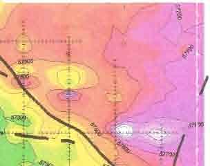
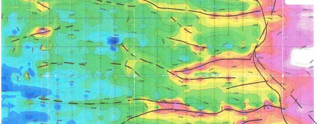
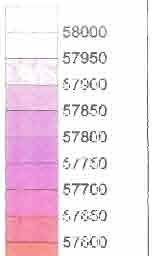
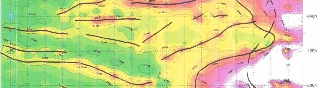
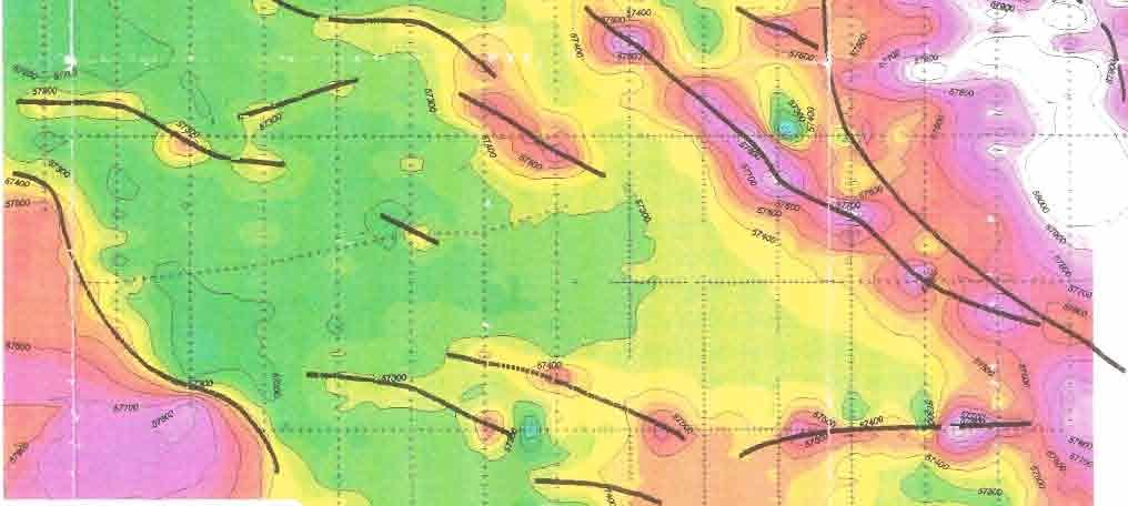
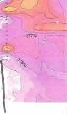
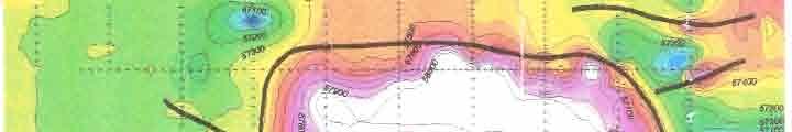
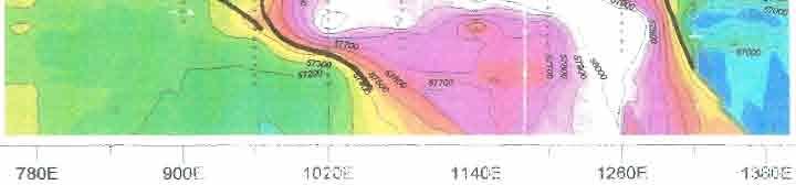
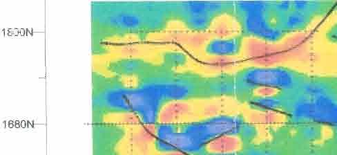
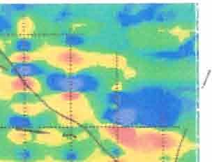
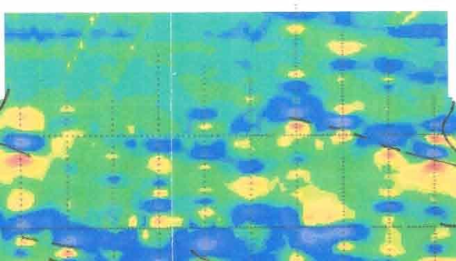
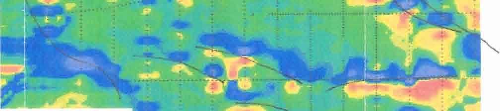
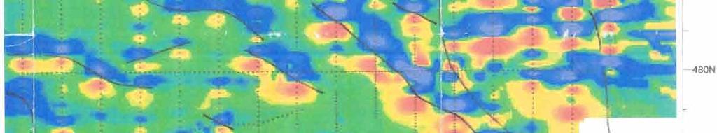
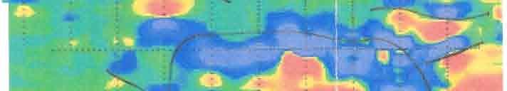
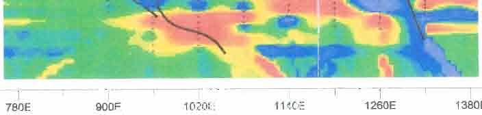
43 The magnetometer surveying was carried out using 2 Scintrex ENVI-MAG total field proton precession magnetometers. The ENVI-iWG is a portable, hi$ sensiity unit which measures the absolute total intensity of the geomagnetic field, and is accurate to +\- 1 nanotesla (nt). The magnetometer measures the precession frequency of protons in a hydrogen-rich medium. Excited by radio frequency energy, the protons emit a signal, with a precessional frequency related to the earth s field through a well known constant, the gyromagnetic ratio. 2.3 Field Procedure One magnetometer was set up as a base station, in order to track and record a an interval of one second the diurnal variations in the earth s magnetic field. The second magnetometer was synchronized with the base unit, and then used for the duration of the field day recording stations at av metre station spacing interval. The field data was then corrected with the base station data, and recorded for later processing. 3. GEOPHYSICAL RESULTS Total field readings were within the range of 56,450 nt to 58,000 nt. Figure 1 is a colour contour plot of the total field data, in nanotesla. Regionally, there is a trend in the data from high magnetic values in the east, down to lower readings on the western side of the property. The ~ gthat h extends down the western side of the property is assumed to result from a lithology change, from sedimentary limestones on the west to volcanics on the east. The contact between these two lithologies had been mapped from surface geology prior to the magnetometer survey, and is plotted as a dashed line on both figures 1 and 2. The contact has also been interpreted from the magnetics, and is plotted as a solid line. Surface mapping of geology indicates a volcanic pluton in the northwest comer of the grid area, and the southern exetent of this pluton is indicated in the magnetics as a magnetically high region across lines 60E to 3OOE, and line 1,800N. Another anomalously high region is seen at the southeastern comer of the grid, across lines 1020E to 1260E, and line 120N. There is no indication of the source of this anomaly from the surface geology, but the very high values of the magnetic field in this area indicate a probable volcanic origin, possibly an isolated pluton, or an extension of the volcanic region that lies on the eastern edge of the funtier Geeseieaces Iwe,
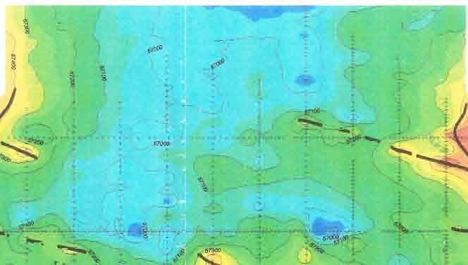
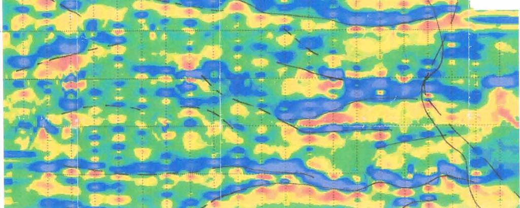
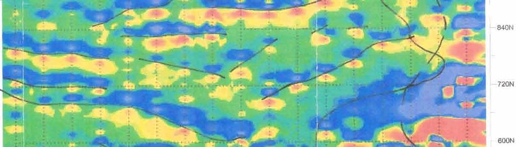
44 ~ * -1- grid. A fourth high region is seen on the easternmost stations of lines 240N and 360N, and the southernmost stations of lines 540N to 720N. However, contouring of these edge values has caused the anomaly to appear much larger on the contour plot than is really justified by the number of stations sampled. I I Multiple narrow magnetically high areas are seen to extend in a generally east east direction, interpreted to be intrusive dykes. The dykes were correlated with the surface geological mapping, and the interpretation of their locations is shown on Figurea. Figure3 is a plot of the first derivative of the magnetic field, ie. the rate of change of the magnetic field along a north south axis. This plot effectively removes the regional trends in the data, and shows the dykes as linear features running along lines of constant slope, with high rates of change on either side of dyke, as the magnetic response increases and then decreases perpendicular to the strike of the dyke. for Frontier Geosciences Inc., Kevin M. Payne, EIT... U eesciences Inc.

45
46
47
48 NNEX
49 L A F A R G E C O R P O R A T I O N L T D. CORPORATE TECHNICAL SERVICES * SERVICES TECHNIQUES Page: 1 Hole Number: 9501 (Richmond - Vananda Quarry) (Units : Meters). FOOTAGE / DESCRIPTION RT LT FROM TO SI02 AL20 FE20 CAO MGO LO1 SO3 IC20 NA P205 CL- NAEQ Number Total _ -_ _ _- _ ( 4.57) Limestone Mg0>5% ( 9.15) Limestone Mg0<5% ( 16.76) Limestone Mg0>5% END OF HOLE
50 L A F A R G E C O R P O R A T l O N LTD. CORPORATE TECHNICAL SERVICES * SERVICES TECHNIQUES ---_--- PROJECT INFORMATION -_ HOLE ( CAMPAIGN... Project : X : Drilled By : Plant Name :Richmond - Vananda Quarry Y : AZIMUTH : DATE : : DIP : -8 Geologist : Marie Degrosbcis Page: 1 Hole Number: 9502 (Richmond - Vananda Quarry) (Units : Meters) FOOTAGE / DESCRIPTION RT LT FROM TO SI02 AL20 FE20 CAO HGO LO1 SO3 K20 NA P205 CL- NAEO Number Total a_ _ _- * ( 11.58) Dyke END OF HOLE
51 L A F A R G E C O R P O R A T I O N LTD. CORPORATE TECHNICAL SERVICES * SERVICES TECHNIQUES PROJECT lnformat]on HOLE ( 9503 ) _-_ CAMPAIGN... Project :11559 X : Drilled By : Plant Name :Richmond - Vananda Quarry Y : AZIMUTH : DATE : : DIP : -6 Geologist : M arie Degrosbois Page: 1 Hole Number: 9503 (Richmond - Vananda Quarry) (Units : Meters) FOOTAGE / DESCRIPTION RT LT FROM TO SI02 AL20 FE20 CAO MGO LO1 SO3 K20 NA20 TI02 P205 CL- NAEQ Number Total a _ _ --- -_ ( 21.34) Limestone ' , ( 6.09) Limestone and Dyke END OF HOLE -
52 L A F A R G E C O R P O R A T f O N L T D. CORPORATE TECHNICAL SERVICES * SERVICES TECHNIQUES --_---_ PROJECT INFORMATION HOLE ( 9504 CAMPAIGN... Project :11559 X : Drilled By : Plant Name :Richmond - Vananda Quarry Y : AZIMUTH : DATE : Z : DIP : Geologist : M arie Oegrosbois (Units : Meters) FOOTAGE / DESCRIPTION RT LT FROM TO SI02 AL2O FEZ0 CAO MGO LO1 SO3 K20 NA20 TI02 P205 CL- NAEQ Number Total * Page: 1 Hole Number: 9504 (Richmond - Vananda Quarry) _-_--_-- --_ ( 9.14) Limes tone ~ END OF HOLE
53 L A F A R G E C O R P O R A T I O N L T D. CORPORATE TECHNICAL SERVICES * SERVICES TECHNIQUES PROJECT INFORMATION HOLE ( 9505 ) CAMPAIGN... Project :11559 X : Drilled By : Plant Name :Richmond - Vananda Quarry Y : AZIMUTH : DATE : : DIP : Geologist : M arie Degrosbois Page: 1 Hole Number: 9505 (Richmond - Vananda Quarry) (Units : Meters) FOOTAGE / DESCRIPTION RT LT FROM TO SI02 AL20 FEZ0 CAO MGO LO1 SO3 IC20 MA20 TI02 P205 CL- NAEQ Number Total _ _- -_ e _ _ ( 27.43) L imes tone b I ( 3.05) Dyke END OF HOLE
54 LAFARGE C O R P O R A T I O N LTD. CORPORATE TECHNICAL SERVICES * SERVICES TECHNIQUES PROJECT INFORMATION HOLE ( 9506 ) CAMPAIGN... Project :11559 X : Dri l led By : Plant Name :Richmond - Vanonda Quarry Y : AZIMUTH : DATE : : DIP : Geologist : Marie Degrosbois Page: 1 Hole Number: 9506 (Richmond - Vananda Quarry) (Units : Meters) FOOTAGE / DESCRIPTION RT LT FROM TO SI02 AL20 FE20 CAO MGO LO1 SO3 K20 NA20 TI02 P205 CL- NAEQ Number Total _ _- _ _ ( 6.10) Dyke ( 3.04) Limestone ( 3.05) Dyke ( Limestone and Dyke ( 12.19) Limes tone : END OF HOLE
55 L A F A R G E C O R P O R A T I O N L T D. CORPORATE TECHNICAL SERVICES * SERVICES TECHNIQUES PROJECT INFORMATION HOLE ( 9507 ) CAMPAIGN Project :11559 X : Drilled By : PLant Name :Richmond - Vananda Quarry Y : AZIMUTH : DATE : ' 2 : DIP : -6 Geologist : M arie Degrosbois Page: 1 Hole Number: 9507 (Richmond - Vananda Quarry) (Units : Meters) FOOTAGE / DESCRIPTION RT LT' FROM TO S102 AL20 FE20 CAO MCO LO1 SO3 U20 NA20 TI02 P205 CL- NAEQ Number Total - -- _* e _ ( 12.19) Limes tone ( 6.10) Limestone and Dyke ( 9-14) L i mes t one ( 3.05) Limestone and Dyke END OF HOLE
56 L A F A R G E C O R P O R A T I O N LTD. CORPORATE TECHNICAL SERVICES * SERVICES TECHNIQUES ---.I--- PROJECT INFORMATION HOLE ( 9508 ) _- -_- CAMPAIGN... Project : X : Drilled By : Plant Name :Richmond - Vananda Quarry Y : AZIMUTH : DATE : : DIP : -6 Geologist : Marie Degrosbois Page: 1 Hole Number: 9508 (Richmond - Vananda Quarry) (Units : Meters) FOOTAGE / DESCRIPTION RT LT FROM ( 15.24) L imes tone ( 3.05) Limestone and Dyke ( 12.19) Limes tone END OF HOLE - - TO SI02 AL2O FE20. -_- CAO MGO LO SO3 U20 _ NA20 TI02 _ P CL- - 1.oo- 1.ooo , NAEQ Number Total _ j ,
57 L A F A R G E C O R P O R A T I O N LTD. CORPORATE TECHNICAL SERVICES * SERVICES TECHNIQUES PROJECT INFORMATION HOLE ( 9509 ) CAMPAIGN I Project : X : Drilled By : Plant Name :Richmond - Vananda Quarry Y : AZIMUTH : DATE : : DIP : -6 Geologist : Marie Degrosbois Page: 1 Hole Number: 9509 (Richmond - yananda Quarry) (Units : Meters) FOOTAGE / DESCRIPTION RT LT FROM TO SI02 AL20 FE20 CAO MGO LO1 SO3 K20 NA20 TI02 $205 CL- NAEQ Number -_ _ e- Total ( 18.29) Limestone ( 3.05) Dyke END OF HOLE
58 9 L A F A R G E C O R P O R A T I O N LTD. CORPORATE TECHNICAL SERVICES * SERVICES TECHNIQUES PROJECT INFORMATION _ HOLE ( CAMPAIGN... Project :11559 X : Drilled By : Plant Name :Richmond - Vananda Quarry Y : AZIMUTH : DATE : : DIP : -6 Geologist : Marie Degrosbois (Units : Meters) FOOTAGE / DESCRIPTION RT LT FROM TO SI02 AL20 FE20 CAO MGO LO1 SO3 K20 NA20 TI02 P205 CL- NAEP Number Total _ _ ( 9.14) Limes tone END OF HOLE Page: 1 Hole Number: 9510 (Richmond - Vananda Quarry) - -_
59 L A F A R G E C O R P O R A T I O N L T D. CORPORATE TECHNICAL SERVICES * SERVICES TECHNIQUES -- PROJECT lnformat]on HOLE ( 9511 ) CAMPAIGN... Project :11559 X : Drilled By : Plant Name :Richmond - Vananda Quarry Y : AZIMUTH : DATE : Z : DIP : -6 Geologist : M arie Degrosbois Page: 1 Hole Number: 9511 (Richmond - Vananda Quarry) (Units : Meters) FOOTAGE / DESCRlPTlON RT LT ( 30.48) lo lo L imes tone END OF HOLE FROM TO SI02 AL2O FE20 CAO MGO LO1 SO3 K _ _ NA20 TI _ P205-1.oo-1.ooo Total -_ -- _---_- -- CL- NAEQ Number -1.oo
60 L A F A R G E CORPORATION LTD. CORPORATE TECHNICAL SERVICES * SERVICES TECHNIQUES ---_-_- PROJECT INFORMATION HOLE ( 9512 ) _----- CAMPAIGN Project :11559 X : Drilled By : Plant Name :Richmond - Vananda Quarry Y : AZIMUTH : DATE : Z : DIP : -6 Geologist : Marie Degrosbois Page: 1 Hole Number: 9512 (Richmond - Vananda Quarry) (Units : Meters) FOOTAGE / DESCRIPTION RT LT FROM TO SI02 AL20 FEZ0 CAO MGO LO1 SO3 K20 NA20 TI02 P205 CL- NAEQ Number Total e c ( 30.48) Limestone END OF HOLE
61 e a L A F A R G E C O R P O R A T I O N L T D. CORPORATE TECHNICAL SERVICES * SERVICES TECHNIQUES PROJECT INFORMATION ----_ HOLE ( 9513 ) _- CAMPAIGN... Project :11559 X : Drilled By : Plant Name :Richmond - Vananda Quarry Y : AZIMUTH : DATE : : DIP : -6 Geologist : M arie Degrosbois Page: 1 Hole Number: 9513 (Richmond - Vananda Quarry) FOOTAGE / DESCRIPTION RT LT FROM TO SI02 AL20 FE20 CAO MGO LO1 SO3 K20 NA20 TI02 P205 CL- NAEQ Number Total _ _ _-- --_ ( 12.19) io io Limestone ( 3.05) Limestone Mg0>5% END OF HOLE
62 I L A F A R G E C O R P O R A T I O N L T D. CORPORATE TECHNICAL SERVICES * SERVICES TECHNIQUES PROJECT INFORMATION HOLE ( 9514 ) _-- CAMPAIGN... Project :11559 X : Drilled By : Plant Name :Richmond - Vananda Quarry Y : AZIMUTH : DATE : ,: DIP : -6 Geologist : M arie Degrosbois Page: 1 Hole Number: 9514 (Richmond - Vananda Quarry) (Units : Meters) FOOTAGE / DESCRIPTION RT LT FROM TO SI02 AL20 FE20 CAO MGO LO1 SO3 K20 NA20 TI02 P205 CL- NAEQ Number e Total _ _.-- _-_ ( 30.48) L imes tone ' END OF HOLE
63 L A F A R C E C O R P O R A T I O N L T D. CORPORATE TECHNICAL SERVICES * SERVICES TECHNIQUES PROJECT INFORMATION HOLE ( 9515 ) _----- CAMPAIGN... Project : X : Drilled By : Plant Name :Richmond - Vananda Quarry Y : AZIMUTH : DATE : : DIP : -6 Geologist : M arie Degrosbois Page: 1 Hole Number: 9515 (Richmond - Vananda Quarry) (Units : Meters) FOOTAGE / DESCRIPTION RT LT FROM TO SI02 AL2O FEZ0 CAO MGO LO1 SO3 K20 NA20 TI02 P205 CL- NAEQ Number Total ( 15.24) Limestone END OF HOLE
64 a LAFARGE CORPORATION LTD. CORPORATE TECHNICAL SERVICES * SERVICES TECHNIQUES ---- PROJECT INFORMATION ---_ HOLE ( 9516 ) _ _----_ CAMPAIGN... Project :11559 X : Drilled By : Plant Name :Richmond - Vananda Quarry Y : AZIMUTH : DATE : : DIP : -6 Geologist : Marie Degrosbois Page: 1 Hole Number: 9516 (Richmond - Vananda Quarry) (Units : Meters) FOOTAGE / DESCRIPTION RT LT FROM TO SI ( 17.68) L imes tone , AL20 FEZ0 CAO MGO LO1 SO3 K20 NA2O TI02 P205 CL- NAEQ Number _- -*--- --_ _ ' ' Total ( 6.70) Dyke END OF HOLE 2 i ,
65 L A F A R G E C O R P O R A T I O N L T D. CORPORATE TECHNICAL SERVICES * SERVICES TECHNIPUES PROJECT INFORMATION HOLE ( 9517 ) CAMPAIGN... Project : X : Drilled By : Plant Name :Richmond - Vananda Puarry Y : AZIMUTH : DATE : : DIP : -6 Geologist : M arie Degrosbois. Page: 1 Hole Number: 9517 (Richmond - Vananda Quarry) (Units : Meters) FOOTAGE / DESCRIPTION RT LT FROM TO SI02 AL20 FE20 CAO MCO LO1 SO3 K20 NA20 TI02 P205 CL- NAEQ Number Total - -_ _ _ ( 30.48) L imes tone ' END OF HOLE
66 t L A F A R G E C O R P O R A T I O N LTD. Page: 1 CORPORATE TECHNICAL SERVICES * SERVICES TECHNIQUES Hole Number: 9518 (Richmond - Vananda Quarry) PROJECT INFORMATION --I HOLE ( 9518 ) _--- r CAMPAIGN... Project :11559 X : Drilled By : Plant Name :Richmond - Vananda Quarry Y : AZIMUTH : DATE : : DIP : -6 Geologist : Marie Degrosbois (Units : Meters) FOOTAGE / DESCRIPTION RT LT FROM TO SI02 AL20 FE20 CAO MGO LO1 SO3 K20 NA20 TI02 P205 CL- NAEQ Number- Total I ( 24.38) L imes tone _ ( 3.05) Limestone Mg0<5% ( 3.05) L imes tone END OF HOLE
67 LAFARGE C O R P O R A T I O N LTD. CORPORATE TECHNICAL SERVICES * SERVICES TECHNIQUES PROJECT INFORMATION HOLE ( 9519 ) CAMPAIGN... Project :11559 X : Drilled By : Plant Name :Richmond - Vananda Quarry Y : AZIMUTH : DATE : : DIP : -6 Geologist : Marie Degrosbois Page: 1 Hole Number: 9519 (Richmond - Vananda Quarry) (Units : Meters) FOOTAGE / DESCRIPTION RT LT FROM TO SI02 AL20 FE20 CAO. MGO LO1 SO3 K20 NA20 TI02 P205 CL- NAEQ Number Total _ _ ( 5.49) ;oo Limes tone ( 3.65) Dyke ( 3.05) Limestone ( 12.19) , Dyke ( 6.10) Limes tone END OF HOLE
68 L A F A R G E C O R P O R A T I O N L T D. CORPORATE TECHNICAL SERVICES * SERVICES TECHNIQUES PROJECT INFORMATION ---_--_ HOLE ( 9520 _ CAMPAIGN... Project :11559 x : Drilled By : Plant Name :Richmond - Vananda Quarry Y : AZIMUTH : DATE : : DIP : -6 Geologist : M arie Degrosbois Page: 1 Hole Number: 9520 (Richmond - Vananda Quarry) FOOTAGE / DESCRIPTION RT LT FROM TO SI02 AL20 FE20 CAO NGO LO1 SO3 K20 NA2O TI02 P205 CL- NAEQ Number Total _-_ _ ( 12.19) IO L imes tone END OF HOLE
69 L A F A R G E C O R P O R A T I O N L T D. CORPORATE TECHNICAL SERVICES * SERVICES TECHNIQUES --. PROJECT INFORMATION HOLE ( _--- - CAMPAIGN... Project -:11559 X : Drilled By : Plant Name :Richmond - Vananda Quarry Y : AZIMUTH : DATE : : DIP : -9 Geologist : M arie Degrosbois Page: 1 Hole Number: 9521 (Richmond - Vananda Quarry) (Units : Meters) FOOTAGE / DESCRIPTION RT LT FROM TO SI02 AL20 FEZ0 CAO MGO LO1 SO3 K20 NA20 TI02 P205 CL- NAEQ Number Total e.-- a_ e _-- _----_ ( 12.19) Limestone ( 3.05) Dyke ( 3.05) Limestone and Dyke ( 12.19) L imes tone END OF HOLE
70 e L A F A R C E C O R P O R A T I O N LTD. CORPORATE TECHNICAL SERVICES * SERVICES TECHNIQUES PROJECT INFORMATION HOLE ( _- CAMPAIGN... Project :11559 X : Drilled By : Plant Name :Richmond - Vananda Quarry Y : AZIMUTH : DATE : Z : DIP : -6 Geologist : Marie Degrosbois Page: 1 Hole Number: 9522 (Richmond - Vananda Quarry) (Units : Meters) FOOTAGE / DESCRIPTION RT LT FROM TO SI02 AL20 FE20.CAO MGO LO1 SO3 K _ ( 15.24) L imes tone END OF HOLE NA2O TI02 P205 CL- NAEQ Number oo Total
71 L A F A R C E C O R P O R A T I O N L T D. CORPORATE TECHNICAL SERVICES * SERVICES TECHNIQUES _- - PROJECT I N,&MAT I ON HOLE ( 9523 ) CAMPAIGN... Project : X : Drilled By : Plant Name :Richmond - Vananda Quarry Y : AZIMUTH : DATE : : DIP : -6 Geologist : M arie Degrosbois Page: 1 Hole Number: 9523 (Richmond - Vananda Quarry) (Units : Meters) FOOTAGE / DESCRIPTION RT LT FROM TO SI02 AL20 FE20 CAO MCO LO1 SO3 IC20 NA20 TI02 P205 CL- NAEQ Number Total _-_ ( 3.05) Limes tone * ( 3.05) Dyke END OF HOLE
72 L A F A R G E C O R P O R A T I O N LTD. CORPORATE TECHNICAL SERVICES * SERVICES TECHNIQUES _--_- PROJECT INFORMATION HOLE ( 9524 ) _--_--_---- CAMPAIGN... Project :11559 X : Drilled By : Plant Name :Richmond - Vananda Quarry Y : AZIMUTH : DATE : : DIP : -6 Geologist : Marie Degrosbois Page: 1 Hole Number: 9524 (Richmond - Vananda Quarry) (Units : Meters) FOOTAGE / DESCRIPTION RT LT FROM TO SI02 AL2O FEZ0 CAO MCO LO1 SO3 K20 NA2O TI02 P205 CL- NAEQ Number Total e _ _-_ - --_ ( 3.05) L imes tone END OF HOLE
73 L A F A R G E C O R P O R A T I O N L T D. CORPORATE TECHNICAL SERVICES * SERVICES TECHNIQUES PROJECT INFORMATION HOLE ( 9526 ) -_ _- CAMPAIGN... Project :11559 X : Drilled By :, Plant Name :Richmond - Vananda Quarry Y : AZIMUTH : DATE : Z : DIP : -6 Geologist : M arie Degrosbois Page: 1 Hole Number: 9526 (Richmond - Vananda Quarry) (Units : Meters) FOOTAGE / DESCRIPTION RT LT FROM TO SI02 AL20 FE20 CAO MGO LO1 SO3 tc20 NA20 TI02 P205 CL- NAEQ Number Total _ _ _- ---_ ( 12.19) Limes tone ' ( 3.05) Limestone and Dyke ( 15.24) L i mes t one END OF HOLE
74 LAFARCE C O R P O R A T I O N LTD. CORPORATE TECHNICAL SERVICES * SERVICES TECHNIQUES PROJECT INFORMATION HOLE ( 9527 ) CAMPAIGN... Project :11559 X : Drilled By : Plant Name :Richmond - Vananda Quarry Y : AZIMUTH : DATE : : DIP : Geologist : Marie Degrosbcis (Units : Meters) FOOTAGE / DESCRIPTION RT LT FROM TO SI02 AL2O FE20 CAO MGO LO1 SO3 K20 NA20 TI02 P205 CL- NAEQ Number Total _ -- --_ _ _ ( 3.05) Limestone and Dyke ( 12.19) Limes tone ( 3.05) Limestone and Dyke ( 3.05) Limes tone END OF HOLE Page: 1 Hole Number: 9527 (Richmond - Vananda Quarry)
75 L A F A R G E CORPORATION LTD. CORPORATE TECHNICAL SERVICES * SERVICES TECHNIQUES - -- PROJECT INFORMATION HOLE ( 9528 ) _ CAMPAIGN... Project :11559 X : Drilled By : Plant Name :Richmond - Vananda Quarry Y : AZIMUTH : DATE : : DIP : -6 Geologist : Marie Degrosbois Page: 1 Hole Number: 9528 (Richmond - Vananda Quarry) (Units : Meters) FOOTAGE / DESCRIPTION RT LT FROM -- -_ -_ ( 27.43) L imes tone ( 3.05) Limestone and Dyke END OF HOLE TO SI02 AL _ FE20 --_-_ SO3 CAO MGO LO _ K2O NA2O -_- -_-- TI P205 CL- NAEQ Number Total _
76 L A F A R G E C O R P O R A T I O N L T D. CORPORATE TECHNICAL SERVICES * SERVICES TECHNIQUES PROJECT INFORMATION HOLE ( 9529 ) CAMPAIGN _- --_--- Project : X : Drilled By : Plant Name :Richmond - Venanda Quarry Y : AZIMUTH : DATE : Z : DIP : -6 Geologist : M arie Degrosbois Page: 1 Hole Number: 9529 (Richmond - Vananda Quarry) (Units : Meters) FOOTAGE / DESCRIPTION RT LT FROM TO SI02 AL20 FE20 CAO MGO LO1 SO3 K20 NA20 TI02 P205 CL- NAEQ Number Total _ _ ( 13.41) Limes tone O.OO ( 4.88) Dyke ( 1.22) Limes tone ( 1-22] Dyke END OF HOLE
77 L A F A R C E CORPORA T I ON-L T D. CORPORATE TECHNICAL SERVICES * SERVICES TECHNIQUES PROJECT INFORMATION _-_ I HOLE ( 9530 CAMPAIGN... Project :11559 X : Drilled By : Plant Name :Richmond - Vananda Quarry Y : AZlMUTH : DATE : : DIP : -6 Geologist : Marie Oegrosbois Page: 1 Hole Number: 9530 (Richmond - Vananda Quarry) (Units : Meters) FOOTAGE / DESCRIPTION RT LT FROM TO SI02 AL20 FE20 CAO #GO LO1 SO3 K20 NA20 TI02 P205 CL- NAEQ Number Total e _ _ _ ( 3.05) Dyke ( 27.43) Limestone ' END OF HOLE
78 L A F A R G E C O R P O R A T I O N L T D. CORPORATE TECHNICAL SERVICES * SERVICES TECHNIQUES PROJECT INFORMATION -----_ HOLE ( 9531 ) CAMPAIGN... Project :11559 X : Drilled By : Plant Name :Richmond - Vananda Quarry Y : AZIMUTH : DATE : : DIP : -6 Geologist : M arie Degrosbois Page: 1 Hole Number: 9531 (Richmond - Vananda Quarry) (Units : Meters) FOOTAGE / DESCRIPTION RT LT FROM TO SI02 AL20 FE20 CAO MGO LO! SO3 K20 NA20 TI02 P205 CL- NAEQ Number Total e---- -_ _ _ ( 12.19) Limestone , ( 3.05) Dyke ( 15.24) L imes tone , END OF HOLE ----_-
79 L A F A R G E C O R P O R A T I O N L T D. CORPORATE TECHNICAL SERVICES * SERVICES TECHNIQUES PROJECT INFORMATION e HOLE ( 9532 ) _ CAMPAIGN... ' Project :11559 X : Drilled By : Plant Name :Richmond - Vananda Quarry Y : AZIMUTH : DATE : Z : DIP : -6 Geologist : M arie Degrosbois Page: 1 Hole Number: 9532 (Richmond - Vananda Quarry) (Units : Meters) FOOTAGE / DESCRIPTION RT LT FROM TO SI02 AL20 FE20 CAO MGO LO1 SO3 K20 NA20 TI02 P205 CL- NAEQ Number Total _ ( 30.48) Limestone END OF HOLE
80 L A F A R G E C O R P O R A T I O N LTD. CORPORATE TECHNICAL SERVICES * SERVICES TECHNIQUES _---- PROJECT INFORMATlON HOLE ( 9533 ) _-----_-_- - -_ CAMPAIGN _-_-_- --_-- Project :11559 X : Drilled By : Plant Name :Richmond - Vananda Quarry Y : AZIMUTH : DATE : : DIP : -6 Geologist : Marie Degrosbois Page: 1 Hole Number: 9533 (Richmond - Vananda Quarry) (Units : Meters) FOOTAGE / DESCRIPTION RT LT FROM TO SI02 AL2O FE20 CAO MGO LO1 SO3 K20 NA20 TI02 P205 CL- NAEQ Number Total e _ ( 14.33) Limestone ( 3.96) Dyke END OF HOLE
81 L A F A R G E C O R P O R A T I O N L T D. CORPORATE TECHNICAL SERVICES * SERVICES TECHNIQUES -_----- PROJECT INFORMATION HOLE ( 9534 ) CAMPAIGN... Project :11559 X : Drilled By : Plant Name :Richmond - Vananda Quarry Y : AZIMUTH : c DATE : : DIP : -6 Geologist : M arie Degrosbois Page: 1 Hole Number: 9534 (Richmond - Vananda Quarry) (Units : Meters) FOOTAGE / DESCRIPTION RT LT FROM TO SI02 AL20 FE20 CAO MGO LO1 SO3 K20 NA20 TI02 P205 CL- NAEQ Number e Total _ ( 18.29) L imes tone lo 10 6;l END OF HOLE
82 , L A F A R G E C O R P O R A T I O N LTD. CORPORATE TECHNICAL SERVICES * SERVICES TECHNIQUES ----_-- PROJECT INFORMATION HOLE ( 9535 ) _--- -_-_-_ CAMPAIGN... Project : X : Dritled By : Plant Name :Richmond - Vananda Quarry Y : AZIMUTH : DATE : : DIP : -6 Geologist : Marie Degrosbcis Page: 1 Hole Number: 9535 (Richmond - Vananda Quarry) (Units : Meters) FOOTAGE / DESCRIPTION RT LT FROM TO SI02 AL20 FE20 CAO MGO LO1 SO3 K20 NA20 TI02 P205 CL- NAEQ Number Total e _ _ ( 24.38) L imes tone ? END OF HOLE
83 L A F A R G E C O R P O R A T I O N LTD. CORPORATE TECHNICAL SERVICES * SERVICES TECHNIQUES PROJECT INFORMATION HOLE ( 9536 ) CAMPAIGN... Project :11559 X : Drilled By : Plant Name :Richmond - Vananda Quarry Y : AZlMUTH : DATE : : DIP : -6 Geologist : Marie Degrosbois Page: 1 Hole Number: 9536 (Richmond - Vananda Quarry) (Units : Meters) FOOTAGE / DESCRIPTION RT LT ' ( 30.48) lo lo L imes tone MGO LO _ _-_ FROM TO SI02 AL20 FE20 CAO ' SO TI02 - P CL- - 1.oo ooo K NA oo NAEQ Number r1.oo IO ' Total END OF HOLE
84 LAFARGE C O R P O R A T I O N LTD. CORPORATE TECHNICAL SERVICES * SERVICES TECHNIQUES PROJECT INFORMATION -_-_ HOLE ( 9537 ) CAMPAIGN... Project :11559 X : Drilled By : Plant Name :Richmond - Vananda Quarry Y : AZlMUTH : 9 DATE : Z : DIP : -6 Geologist : Marie Degrosbois Page: 1 Hole Number: 9537 (Richmond - Vananda Quarry) FOOTAGE DESCRIPTION RT LT FROM TO SI02 AL20 FE20 CAO MCO LO1 SO3 K20 NA20 TI02 P205 CL- NAEQ Number Total _ _ _-_ ( 9.14) Limestone and Dyke ( 15.85) Limes tone ( 2.44) Dyke ( 3.05) Limestone and Dyke END OF HOLE
85 L A F A R G E C O R P O R A T I O N LT.D. CORPORATE TECHNICAL SERVICES * SERVICES TECHNIQUES PROJECT INFORMATION ----_ HOLE ( 9538 ) CAMPAIGN... Project :11559 X : Drilled By : Plant Name :Richmond - Vananda Quarry Y : AZIMUTH : DATE : : DIP : -6 Geologist : M arie Degrosbois Page: 1 Hole Number: 9538 (Richmond - Vananda Quarry) (Units : Meters) FOOTAGE / DESCRIPTION RT LT FROM TO SI02 AL2O FE20 CAO MGO LO1 SO3 K20 NA20 TI02 P205 CL- NAEQ Number -- -_ _ e _ ( 20.73) Limestone io io ( 9.75) Dyke END OF HOLE Total *
86 L A F A R G E C O R P O R A T I O N L T D. CORPORATE TECHNICAL SERVICES * SERVICES TECHNIQUES PROJECT INFORMATION HOLE ( 9539 ) CAMPAIGN... Project :11559 X : Drilled By :. Plant Name :Richmond - Vananda Quarry Y : ' AZIMUTH : DATE : : DIP : -6 Geologist : M arie Degrosbois Page: 1 Hole Number: 9539 (Richmond - Vananda Quarry) (Units : Meters) FOOTAGE / DESCRIPTION RT LT FROM TO SI02 AL20 FE20 CAO MGO LO1 SO3 K20 NA20 TI02 P205 CL- NAEfd Number _ I Total _ ( 22.56) L i mes tone ( 6.09) Dyke ( 1.83) Limestone END OF HOLE
87 L A F A R G E C O R P O R A T l O N L T D. CORPORATE TECHNlCAL SERVICES * SERVlCES TECHNlQUES PROJECT INFORMATION e HOLE ( 9540 ) CAMPAIGN... Project :11559 X : Drilled By : Plant Name :Richmond - Vananda Quarry Y : AZIMUTH : 18 DATE : Z : DIP : -6 Geologist : M arie Degrosbois Page: 1 Hole Number: 9540 (Richmond - Vananda Quarry) (Units : Meters) FOOTAGE / OESCRlPTlON RT LT FROM TO Si02 AL ( 22.86) ' Limestone MGO FE20 CAO _ LO SO3-1.oo oo K20 NA P205 CL- NAEQ Number Total _ * ( 4.57) Dyke END OF HOLE
88 e L A F A R G E C O R P O R A T I O N L T D. Page: 1 CORPORATE TECHNICAL SERVICES * SERVICES TECHNIQUES Hole N d e r : 9541 (Richmond - Vananda Quarry) PROJECT INFORMATION HOLE ( 9541 ) _- CAMPAIGN... Project :11559 X : Drilled By : Plant Name :Richmond - Vananda Quarry Y : AZIMUTH : DATE : Z : DIP : -6 Geologist : M arie Degrosbois (Units : Meters) FOOTAGE / DESCRIPTION RT LT FROM TO SI02 AL20 FE20 CAO MGO LDI SO3 K20 NA P205 CL- NAEQ Number Total -- _ _ ( 27.43) L imes tone * END OF HOLE
89 L A F A R G E C O R P O R A T I O N L T D. CORPORATE TECHNICAL SERVICES * SERVICES TECHNIQUES PROJECT INFORMATION HOLE ( _-- - CAMPAIGN... Project :11559 X : Drilled By : Plant Name :Richmond - Vananda Quarry Y : AZIMUTH : DATE : Z : DIP : -6 Geologist : M arie Degrosbois Page: 1 Hole Number: 9542 (Richmond - Vananda Quarry) (Units : Meters) FOOTAGE / DESCRIPTION RT LT FROM TO SI02 AL20 FE20 CAO MGO LO1 S03. K20 NA20 TI02 P205 CL- NAEQ Number _ _ _ ( 24.38) Limes tone ( 6.10) Limestone and Dyke END OF HOLE ' Total, -_
90 L A F A R C E CORPORATION LTD. Page: 1 CORPORATE TECHNICAL SERVICES * SERVICES TECHNIQUES Hole Number: 9543 (Richmond - Vananda Quarry) PROJECT INFORMATION --_ HOLE ( 9543 ) _----- CAMPAIGN... Project :11559 X : Drilled By : Plant Name :Richmond - Vananda Quarry Y : AZIMUTH : DATE : : DIP : -6 Geologist : Marie Degrosbois (Units : Meters) FOOTAGE / DESCRIPTION RT LT FROM TO SI02 AL20 FE20 CAO MGO LO1 SO3 K2O NA20 TI02 P205 CL- NAEQ Number Total _ _-_--_ ( 30.48) Limestone END OF HOLE -----_
91 L A F A R G E C O R P O R A T I O N L T D. CORPORATE TECHNfCAL SERVICES * SERVICES TECHNfPUES -----_- PROJECT INFORMATION HOLE ( 9544 ) CAMPAIGN... Project :11559 X : Drilled By : Plant Name :Richmond - Vananda Quarry Y : AZIMUTH : DATE : : DIP : -6 Geologist : M arie Degrosbois Page: 1 Hole Number: 9544 (Richmond - Vananda Quarry) (Units : Meters) FOOTAGE / DESCRIPTION RT LT FROM TO SI AL ( 30.48) L i mes tone END OF HOLE oo FE20 CAO MGO LO SO K20-1.oo 0.01 NA TI02 P205 CL- NAEQ Number Total --_ _ oo oo
92 L A F A R G E C O R P O R A T I O N L T D. Page: 1 CORPORATE TECHNICAL SERVICES * SERVICES TECHNIQUES Hole Number: 9545 (Richmond - Vananda Quarry) PROJECT lnformatlon -_-_--_-_---_ HOLE ( 9545 ) CAMPAIGN I Project :11559 X : Drilled By : Plant Name :Richmond - Vananda Quarry Y : AZIMUTH : DATE : : DIP : -6 Geologist : Marie Degrosbois (Units : Meters) FOOTAGE / DESCRIPTION RT LT FROM TO SI02 AL20 FE20 CAO MGO LO1 SO3 K20 NA20 TI02 P205 CL- NAEQ Number Total _ _ ( 28.96) L imes tone ( 1.52) Dyke END OF HOLE
93 L A F A R G E C O R P O R A T I O N L T D. CORPORATE TECHNICAL SERVICES * SERVICES TECHNIQUES PROJECT INFORMATION HOLE ( 9546 ) _--- -_- - - CAMPAIGN Project :11559 X : Drilled By : Plant Name :Richmond - Vananda Quarry Y : AZIMUTH : DATE : Z : DIP : -6 Geologist : Marie Degrosbois -- Hole Number: Page: (Richmond - Vananda Quarry) (Units : Meters) FOOTAGE / DESCRIPTION RT LT FROM TO SI02 AL20 FE20 CAO MGO LO1 SO3 K20 NA20 TI02 P205 CL- NAEP Number Total ( 27.43) Limes tone END OF HOLE _--_ _- --_--_ _ ,
94 L A F A R G E C O R P O R A T I O N L T D. CORPORATE TECHNlCAL SERVlCES * SERVICES TECHNlQUES _--- - PROJECT lnformat1on Project :11559 X : Drilled fly : Plant Name :Richmond - Vananda Quarry Y : AZIMUTH : DATE : : DIP : -6 Geologist : Marie Degrosbois HOLE ( 9547 ) CAMPAIGN... Page: 1 Hole Number: 9547 (Richmond - Vananda Quarry) (Units : Meters) FOOTAGE / DESCRlPTlON RT LT FROM TO SI02 AL2O FE20 CAO MGO LO1 SO3 K20 NA20 TI02 P205 CL- NAEQ Number Total... _ e _ ( 9.14) 10 IO L i mes tone ( 3.05) Limestone and Dyke ( 9.15) Limes tone END OF HOLE
95 ~ LAFARGE C O R P O R A T I O N LTD. CORPORATE TECHNICAL SERVICES * SERVICES TECHNIQUES -----_- PROJECT INFORMATION HOLE ( 9548 ) _-- CAMPAIGN... Project :11559 X : Drilled By : Plant Name :Richmond - Vananda Quarry Y : AZIMUTH : DATE : Z : DIP : -6 Geologist : Marie Degrosbois Page: 1 Hole Number: 9548 (Richmond - Vananda Quarry) (Units : Meters) FOOTAGE / DESCRIPTION RT LT FROM TO SI02 AL20 FE20 CAO MGO LO1 SO3 K20 #A20 TI02 P205 CL- NAEQ Number Total _ ( 4.88) L i mes t one ( 1.22) Dyke ( 3.04) Limestone and Dyke ( 6.10) Limestone ( 6.10) Limestone and Dyke ( 9.14) L imes tone END OF HOLE
96 LAFARGE C O R P O R A T I O N LTD. CORPORATE TECHNICAL SERVICES * SERVICES TECHNIQUES -_----- PROJECT INFORMATION _ HOLE ( 9549 ) - -_ _-_-_- --_- CAMPAIGN... Project :11559 X : Drilled By : Plant Name :Richmond - Vananda Quarry Y : AZIMUTH : DATE : : DIP : -6 Geologist : Marie Degrosbois Page: 1 Hole Number: 9549 (Richmond - Vananda Quarry) (Units : Meters) FOOTAGE / DESCRIPTION RT LT FROM TO SI02 AL20 FE20 CAO MGO LO1 SO3 K20 NA20 TI02 P205 CL- NAEQ Number Total - _- ---e _ _ ( 24.38) L imes tone _ ( 3.05) Limestone and Dyke ( 3.05) Limestone EN0 OF HOLE
97 L A F A R G E C O R P O R A T I O N L T D. CORPORATE TECHNICAL SERVICES * SERVICES TECHNIQUES - -- PROJECT INFORMATION HOLE ( _- CAMPAIGN... Project :11559 X : Plant Name :Richmond - Vananda Quarry Y : AZIMUTH : 34 Drilled By : DATE : Z : DIP : -6 Geologist : Marie Degrosbois Page: 1 Hole Number: 9550 (Ric'hmond - Vananda Quarry) (Units : Meters) FOOTAGE / DESCRIPTION RT LT FROM TO S102. AL20 FEZ0 CAO MGO LO1 SO3 KZO NA20 TI02 P205 CL- NAEQ Number Total _ _ ( 10.67) Dyke ( 16.76) L imes tone ( 0.92) Dyke END OF HOLE.
98 L A F A R G E C O R P O R A T I O N LTD. CORPORATE TECHNICAL SERVICES * SERVICES TECHNIQUES PROJECT INFORMATION HOLE ( 9551 ) CAMPAIGN... Project :11559 X : Drilled By : Plant Name :Richmond - Vananda Quarry Y : AZIMUTH : 34 DATE : Z : DIP : -6 Geologist : Marie Degrosbois Page: 1 Hole Number: 9551 (Richmond - Vananda Quarry) (Units : Meters) FOOTAGE / DESCRIPTION RT LT FROM TO SI02 AL2O FE20 CAO MGO LO1 SO3 K20 NA20 TI02 P205 CL- NAEP Number Total _ _ _ _ ( 30.48) L i mes t one , ' END OF HOLE
99 L A F A R C E C O R P O R A T l O N LTD. CORPORATE TECHNICAL SERVlCES * SERVlCES TECHNIQUES PROJECT INFORMT1ON _ _--- HOLE ( 9552 ) _- - CAMPAIGN Project :11559 X : Drilled By : Plant Name :Richmond - Vananda Quarry ' Y : AZIMUTH : 18 DATE : Z : DIP : -6 Geologist : Marie Degrosbois Page: 1 Hole Number: 9552 (Richmond - Vananda Quarry) FOOTAGE / DESCRlPTlON RT LT FROM TO SI02 AL2O FE20 CAO MCO LO1 SO3 K20 NA P205 CL- NAEP Number Total _ -_-_-_ ( 3.05) Limestone Mg0>5% ( 3.05) Limestone and Dyke ( 3.04) Dyke ( 3.05) L imes tone ( 3.05) Dyke END OF HOLE
100 L A F A R G E C O R, P O R A T I O N L T O. CORPORATE TECHNICAL SERVICES * SERVICES TECHNIQUES -- PROJECT INFORMATION HOLE ( 9553 ) CAMPAIGN... Project :11559 X : Drilled By : Plant Name :Richmond - Vananda Quarry Y : AZIMUTH : DATE : : DIP : -6 Geologist : M arie Degrosbois Page: 1 Hole Number: 9553 (Richmond - Vananda Quarry) (Units : Meters) FOOTAGE / DESCRIPTION RT LT FROM TO SI02... _ ( 21.95) Limes tone ( 2.43) Dyke ( 6.10) L imes tone END OF HOLE CAO MGO AL20 -_-_- FE LO1 so3 K NA P205 CL- NAEQ Number ooo ooo Total _ *
101 L A F A R G E C O R P O R A T I O N L T D. CORPORATE TECHNICAL SERVICES * SERVICES TECHNIQUES PROJECT INFORMATION ---_-_ HOLE ( 9554 ) _-_ -_----- CAMPAIGN... Project :11559 X : Drilled Eiy : Plant Name :Richmond - Vananda Quarry Y : AZIMUTH : DATE : : DIP : -6 Geologist : M arie Degrosbois Page: 1 Hole Number: 9554 (Richmond - Vananda Quarry) (Units : Meters) FOOTAGE / DESCRIPTION RT LT --_ ( 30.48) lo lo Limes tone , END OF HOLE FE20 -_--_ CAO MGO LO1 SO3 K _ NA20 --_-- TI02 _- - - P205 CL oo-1.ooo FROM TO SI02 AL Total NAEQ Number -1.oo
102 L A F A R G E CORPORATION LTD. CORPORATE TECHNICAL SERVICES * SERVICES TECHNIQUES _--_-_- PROJECT INFORMATION HOLE ( 9555 ) _--_- CAMPAIGN... Project :11559 X : Drilled By : Plant Name :Richmond - Vananda Quarry Y i AZIMUTH : 9 DATE : : DIP : -6 Geologist : Marie Degrosbois Page: 1 Hole Number: 9555 (Richmond - Vananda Quarry) FOOTAGE / DESCRIPTION RT LT FROM TO _ ( 21.34) L imes tone END OF HOLE SI02 AL _- SO3 K20 NA _ FE20 CAO MGO LO TI02 P205 CL NAEP Number. -_ Total._
103 L A F A R G E C O R P O R A T I O N LTD. CORPORATE TECHNICAL SERVICES * SERVICES TECHNIQUES _-- PROJECT INFORMATION HOLE ( 9556 ) ----_----_- _-_-_- CAMPAIGN... Project :11559 X : Drilled By : Plant Name :Richmond - Vananda Quarry Y : AZIMUTH : 9 DATE : Z : DIP : -6 Geologist : Marie Degrosbois Page: 1 Hole Number: 9556 (Richmond - Vananda Quarry) (Units : Meters) FOOTAGE / DESCRIPTION RT LT FROM TO SI02 AL2O FE20 CAO MCO LO1 SO3 IC20 MA20 TI02 P205 CL- NAEQ Number Total * ( 12.19) Limes tone ( 3.05) ; Limestone and Dyke ( 3.05) Limestone 18.29' ( 3.05) Dyke ( 3.04) Limestone and Dyke ( 6.10) Dyke END OF HOLE
104 L A F A R C E C O R P O R A T I O N LTD. CORPORATE TECHNICAL SERVICES * SERVICES TECHNIQUES - -_ PROJECT INFORMATION -_ HOLE ( 9557 ) _- --- Project :11559 X : Drilled By : Plant Name :Richmond - Vananda Quarry Y : AZIMUTH : DATE : : DIP : -6 Geologist : Marie Degrosbcis CAMPAIGN... Page: 1 Hole Number: 9557 (Richmond - Vananda Quarry) (Units : Meters) FOOTAGE / DESCRIPTION RT LT ( 30.48) lo lo L imes tone FROM TO SI02 AL20 FEZ0 CAO MGO LO1 SO3 _ : K NA TI02 P205 CL- --_-_ NAEQ Number Total _-----_ ooo END OF HOLE
105 L A F A R G E C O R P O R A T I O N LTD. CORPORATE TECHNICAL SERVICES * SERVICES TECHNIQUES --- -_ PROJECT INFORMATION _-_ HOLE ( 9558 ) _--_-_----- _-- -- CAMPAIGN... Project :11559 X : Drilled By : Plant Name :Richmond - Vananda Quarry Y : AZIMUTH : DATE : : DIP : -6 Geologist : Marie Degrosbois Page: 1 Hole Number: 9558 (Richmond - Vananda Quarry) (Units : Meters) FOOTAGE / DESCRIPTION RT LT FROM TO SI02 AL2O FE20 CAO MGO LO1 SO3 K20 NA2O TI02 P205 CL- NAEQ Number Total _ _- _ ( 6.10) Limestone ( 3.04) Limestone and Dyke ( 15.24) L imes tone END OF HOLE
106 L A F A R G E C O R P O R A T I O N LTD. CORPORATE TECHNICAL SERVICES * SERVICES TECHNIQUES PROJECT INFORMATION - --_----_ HOLE ( 9559 ) _- CAMPAIGN... Project :11559 X : Drilled By : Plant Name :Richmond - Vananda Quarry Y : AZIMUTH : DATE : Z : DIP : -6 Geologist : Marie Degrosbois Page: 1 Hole Number: 9559 (Richmond - Vananda Quarry) (Units : Meters) FOOTAGE / DESCRIPTION RT LT ( 30.48) lo lo L i mes tone EN0 OF HOLE FROM TO _ SI02 A120 FE20 CAO _- MGO _-_--_-- LO SO oo K20 NA20 TI02 _--_---_---_ P CL NAEQ Number -_--_ oo Total
107 L A F A R G E C O R P O R A T I O N LTD. CORPORATE TECHNICAL SERVICES * SERVICES TECHNIQUES PROJECT INFORMATION HOLE ( 9560 ) -' CAMPAIGN... Project :11559 X : Drilled By : Plant Name :Richmond - Vananda Quarry Y : AZIMUTH : DATE : : DIP : -6 Geologist : Marie Degrosbois Page: 1 Hole Number: 9560 (Richmond - Vananda Quarry) ~~~ (Units : Meters) FOOTAGE / DESCRIPTION RT LT FROM ( 24.38) i mestone _ FEZ0 MGO LO1 so3 K20 MA20 TI02 P205 CL- NAEQ Number Total --_-_ _ _-_--- TO SI02 AL20 CAO oo O OOO ( 3.05) , Limestone and Dyke END OF HOLE
108 L A F A R G E C O R P O R A T I O N LTD. CORPORATE TECHNICAL SERVICES * SERVICES TECHNIQUES Page: 1 Hole Number: 9561 (Richmond - Vananda Quarry) FOOTAGE / DESCRIPTION RT LT FROM TO SI ( 18.29) Limestone , AL END OF HOLE 0.' FE20 CAO MGO LO I.--- _---_ SO3 K20 NA20 TI02 --_ _ NAEQ Number Total P205 CL ooo _----_
109 LAFARGE CORPORATlON LTD. Page: 1 CORPORATE TECHNICAL SERVICES * SERVICES TECHNIQUES Hole Number: 9562 (Richmond - Vananda Quarry) _- --- PROJECT INFORMATION HOLE ( 9562 ) CAMPAIGN... Project :11559 X : Drilled By : Plant Name :Richmond - Vananda Quarry Y : AZIMUTH : DATE : : 4.71 OIP : -6 Geologist : Marie Degrosbois (Units : Meters) FOOTAGE / DESCRIPTION RT LT FROM TO SI02 AL20 FE20 CAO MGO LO1 SO3 K20 NA20 TI02 P205 CL- NAEQ Number Total _ _ _ _ _ ( 21.34) L i mes tone ( 6.09) Limestone and Dyke END OF HOLE
110 L A F A R G E C O R P O R A T I O N LTD. CORPORATE TECHNICAL SERVICES * SERVICES TECHNIQUES PROJECT INFORMATION HOLE ( 9563 ) CAMPAIGN... Project :11559 X : Drilled By : Plant Name :Richmond - Vananda Quarry Y : AZIMUTH : DATE : : DIP : -6 Geologist : Marie Degrosbois Page: 1 Hole Number: 9563 (Richmond - Vananda Quarry) (Units : Meters) FOOTAGE / DESCRIPTION RT LT FROM TO SI02 ALZO FE20 CAO MGO LO1 SO3 K20 NA20 TI02 P205 CL- NAEQ Number Total _ ( 6.10) Limestone and Dyke ( 6.09) Dyke ( 3.05) L i mestone ( 6.10) Limestone Mg0<5% ( 3.04) Limestone and Dyke ( 6.10) ' L imes tone END OF HOLE
111 LAFARGE C O R P O R A T I O N LTD. Page: 1 CORPORATE TECHNICAL SERVICES * SERVICES TECHNIQUES Hole Number: 9564 (Richmond - Vananda Quarry) PROJECT INFORMATION HOLE ( 9564 ) CAMPAIGN... Project :11559 X : Drilled By : Plant Name :Richmond - Vananda Quarry Y : AZIMUTH : DATE : : DIP : -6 Geologist : Marie Degrosbois (Units : Meters) FOOTAGE / DESCRIPTION RT LT FROM TO SI02 AL2O FE20 CAO MGO LO1 SO3 K20 NA20 TI02 P205 CL- NAEQ Number Total _ ( 27.43) Limestone ( 1.53) Dyke END OF HOLE
112 L A F A R G E C O R P O R A T I O N LTD. CORPORATE TECHNICAL SERVICES * SERVICES TECHNIQUES PROJECT 1NFORMATlON HOLE ( 9565 ) _ CAMPAIGN Pro j ec t :11559 X : Drilled By : Plant Name :Richmond - Vananda Quarry Y : AZIMUTH : DATE : Z : DIP : -6 Geologist : Marie Degrosbois Page: 1 Hole Number: 9565 (Richmond - Vananda Quarry) (Units : Meters) FOOTAGE / DESCRIPTION RT LT FROM TO SI02 AL20 FE20 CAO MGO LOI SO3 K20 NA2O TI02 P205 CL- NAEQ Number Total _ -_- - _-_ _- --_ ( 27.43) L imes tone ( 3.05) Limestone and Dyke END OF HOLE
113 a L A F A R G E C O R P O R A T I O N LTD. CORPORATE TECHNICAL SERVICES * SERVICES TECHNIQUES PROJECT INFORMATION HOLE ( 9566 ) CAMPAIGN ---_- Project :11559 X : Drilled By : Plant Name :Richmond - Vananda Quarry Y : AZIMUTH : DATE : : DIP : -6 Geologist : Marie Degrosbois Page: 1 (Richmond Hole - Vananda Number: Quarry) 9566 (Units : Meters) FOOTAGE / DESCRIPTION RT LT FROM TO SI02 AL20 FE20 CAO MGO LO1 SO3 K20 NA20 TI02 P205 CL- NAEQ Number Total ( 9.14) L imes tone ( 3.05) ' Limestone Mg0>5% ( 3.05) 11 li Limestone Mg0<5% ( 4.88) Limes tone ( 4.26) Dyke END OF HOLE
114 L A F A R G E C O R P O R A T I O N L T D. Page: 1 CORPORATE TECHNICAL SERVICES * SERVICES TECHNIQUES Hole Number: 9567 (Richmond - Vananda Quarry) - -_-- PROJECT 1NFORMATlON _------_ HOLE ( 9567 ) _---_--. CAMPAIGN Project :11559 X : Drilled By : Plant Name :Richmond - Vananda Quarry Y : AZIMUTH : 9 DATE : : DIP : -6 Geologist : M arie Degrosbois (Units : Meters) FOOTAGE / DESCRIPTION RT LT FROM TO SI02 A120 FE20 CAO MGO LO1 SO3 K20 NA20 TI02 P205 CL- NAEQ Number Total _---._ _ _ ( 18.29) L imes tone EN0 OF HOLE
115 L A F A R G E C O R P O R A T I O N LTO. CORPORATE TECHNICAL SERVICES * SERVICES TECHNIOUES - -_-- PROJECT INFORMATION Project :11559 x : 3a Drilled By : Plant Name :Richmond - Vananda Quarry Y : AZIMUTH : 9 DATE : : DIP : -6 Geologist : Marie Oegrosbois HOLE ( 9568 ) CAMPAIGN... Page: 1 Hole Number: 9568 (Richmond - Vananda Quarry) (Units : Meters) FOOTAGE / DESCRIPTION RT LT FROM TO SI02 AL2O FE20 CAO MGO LO1 SO3 IC20 NA2O TI02 P205 CL- NAEQ Number Total ^ ( 3.05) L imes tone ( 6.09) Dyke ( 6.10) Limes tone EN0 OF HOLE
116 L A F A R G E C O R P O R A T I O N LTD. CORPORATE TECHNICAL SERVICES * SERVICES TECHNIQUES - PROJECT INFORMATION _ _ HOLE ( 9569 ) Project :11559 X : Plant Name :Richmond - Vananda Quarry" Y : AZIMUTH : 2 : DIP : -9 Page: 1 Hole Number: 9569 (Richmond - Vananda Quarry) (Units : Meters) FOOTAGE / DESCRIPTION RT'LT FROM TO SI02 AL20 FE20 CAO MGO LO1 SO3 K20 NA20 TI02 P205 CL- NAEQ Number Total e _ _ ( 6.10) Limestone Mg0<5% ( 24.38) L imes tone END OF HOLE
117 L A F A R G E C O R P O R A T I O N L T D. Page: 1 CORPORATE TECHNICAL SERVICES * SERVICES TECHNIQUES Hole Number: 9570 (Richmond - Vananda Quarry) PROJECT INFORMATION HOLE ( 9570 CAMPAIGN... Project :11559 x : Drilled By : Plant Name :Richmond - Vananda Quarry Y : AZIMUTH : DATE : : DIP : -9 Geologist : Marie Degrosbois. (Units : Meters) FOOTAGE / DESCRIPTION RT LT FROM TO SI02 AL20 FE20 CAO MGO LO1 SO3 K20 NA20 TI02 P205 CL- NAEQ Number Total... _- _ _ ( 30.48) L imes tone END OF HOLE _- _ _
118 L A F A R C f C O R P O R A T I O N L T D. CORPORATE TECHNICAL SERVICES * SERVICES TECHNIQUES PROJECT INFORMATION HOLE ( 9571 ) CAMPAIGN _-_ Project :11559 X : Drilled By : Plant Name :Richmond - Vananda Quarry Y : AZIMUTH : DATE : : DIP : -6 Geologist : M arie Degrosbois (Units : Meters) FOOTAGE / OESCRIPTION RT LT FROM TO SI02 AL2O FE20 CAO MCO LO1 SO3 K2O NA20 TI02 P205 CL- NAEQ Number Total _ ( 9.14) L i mes tone END OF HOLE Page: 1 Hole Number: 9571 (Richmond - Vananda Quarry) _-
119 LAFARGE C O R P O R A T I O N LTD. CORPORATE TECHNICAL SERVICES * SERVICES TECHNIQUES _ PROJECT INFORMATION -- -_ HOLE ( 9573 ) - -_ CAMPAIGN _'- - Project :11559 X : Drilled By : Plant Name :Richmond - Vananda Quarry Y : AZIMUTH : ' DATE : : DIP : -9 Geologist : Marie Degrosbois Page: 1 Hole Number: 9573 (Richmond - Vananda Quarry) (Units : Meters) FOOTAGE / DESCRIPTION RT LT FROM TO SI02 AL20 FE20 CAO MGO LO1 SO3 K20 NA20 TI02 P205 CL- NAEQ Number Total _-- ---_ ( 6.10) Limestone Mg0<5% ( 3.04) L imes tone ( 3.05) Limestone Mg0<5% ( 3.05) L i mes tone ( 3.05) Limestone Mg0<5% ( 3.05) Limestone ( 3.04) Limestone Mg0<5% ( 6.10) Limestone END OF HOLE
120 L A F A R C E C O R P O R A T I O N. L T D. CORPORATE TECHNICAL SERVICES * SERVICES TECHNIQUES PROJECT INFORMATION -_ HOLE ( 9574 ) ----_ _- - CAMPAIGN... Project :11559 X : Drilled By : Plant Name :Richmond - Vananda Quarry Y : AZIMUTH : DATE : : DIP : -9 Geologist : Marie Degrosbois (Units : Meters) FOOTAGE / DESCRIPTION RT LT FROM TO SI02 AL20 FEZ0 CAO MGO LO1 SO3 K20 NA20 TI02 P205 CL- NAEQ Number Total _-_- ----_ ( 30.48) Limes tone END OF HOLE Page: 1 (Richmond Hole - Vananda Number: Quarry) 9574 _--
121 L A F A R G E C O R P O R A T I O N L T D. CORPORATE TECHNICAL SERVICES * SERVICES TECHNIQUES _-_---- PROJECT INFORMATION HOLE ( 9575 ) _--_---- CAMPAIGN - - Project :11559 X : Drilled By : Plant Name :Richmond - Vananda Quarry Y : AZIMUTH : DATE : : DIP : -9 Geologist : M arie Degrosbois Page: 1 Hole Number: 9575 (Richmond - Vananda Quarry) (Units : Meters) FOOTAGE / DESCRIPTION RT LT FROM TO SI02 AL20 FEZ0 CAO MGO LO1 SO3 K20 NA20 TI02 P205 CL- NAEQ Number Total _ _-- -_ _- -_ _ _ ( 10.36) Overburden ( 20.12) L imes tone END OF HOLE
122 L A F A R G E C O R P O R A T I O N LTD. CORPORATE TECHNICAL SERVICES * SERVICES TECHNIQUES - -_- PROJECT INFORMATION _ HOLE ( 9576 ) _-- c - CAMPAIGN... Project : X : Plant Name :Richmond - Vananda Quarry Y : AZIMUTH : Drilled By : DATE : : DIP : -6 Geologist : Marie Degrosbois Page: 1 Hole Number: 9576 (Richmond - Vananda Quarry) (Units : Meters) FOOTAGE / DESCRIPTION RT LT FROM TO SI02 AL20 FEZ0 CAO MGO LO1 SO3 K20 MA20 TI02 P205 CL- NAEQ Number e e _ _- --_ _ ( 3.05) Limestone Mg0>5% ( 3.05) Limestone Mg0<5% ( 9.14) 2 2, Dyke ( 6.10) i Limestone and Dyke ( 9.14) Limes tone END OF HOLE '
123 LAFARGE COR-PORATION LTD. CORPORATE TECHNICAL SERVICES * SERVICES TECHNIQUES _-- -- PROJECT INFORMATION ----_----_--- --_ HOLE ( 9577 ) CAMPAIGN... Pro j ec t :11559 X : Drilled By : Plant Name :Richmond - Vananda Quarry Y : AZIMUTH : DATE : : DIP : -9 Geologist : Marie Degrosbois Page: 1 Hole Number: 9577 (Richmond - Vananda Quarry) (Units : Meters) FOOTAGE / DESCRIPTION RT LT FROM TO SI02 AL2O FE20 CAO MGO LO1 SO3 K20 NA20 TI02 P205 CL- NAEQ Number Total... _- _ e _ ( 3.05) Overburden ( 12.19) L imes tone ' , ( 3.05) Limestone and Dyke END OF HOLE
124 L A F A R G E CORPORATION LTD. CORPORATE TECHNICAL SERVICES * SERVICES TECHNIQUES PROJECT INFORMATION HOLE ( 9578 ) CMPAlGN... Project :11559 X : Drilled By : Plant Name :Richmond - Vananda Quarry Y : AZIMUTH : DATE : : DIP : -9 Geologist : Marie Degrosbois Page: 1 Hole Number: 9578 (Richmond - Vananda Quarry) (Units : Meters) FOOTAGE / DESCRIPTION RT LT FROM TO SI02 AL20 FEZ0 CAO HGO LO1 SO3 K2O NA20 TI02 P205 CL- NAEQ Number Total _-- I ( 1.52) Limestone Mg0>5% ( 3.05) Limestone Mg0<5% ( 4.57) L i mes tone ( 3.05) Limestone Mg0<5% ( 4.57) Limes tone END OF HOLE
125 L A F A R G E C O R P O R A T I O N L T O. CORPORATE TECHNICAL SERVICES * SERVICES TECHNIQUES -_----- PROJECT INFORMATION HOLE ( 9579 ) _----_ CAMPAIGN... Project :11559 X : Drilled By : Plant Name :Richmond - Vananda Quarry Y : AZIMUTH : DATE : : DIP : -9 Geologist : M arie Oegrosbois Page: 1 Hole Number: 9579 (Richmond - Vananda Quarry) (Units : Meters) FOOTAGE / OESCRlPTlON RT LT FROM TO SI02 AL20 FE20 CAO MGO LO1 SO3 K20 NA20 TI02 P205 CL- NAEQ Number Total _---- -_--_ _ _ --_ ( 9.14) Limes tone ( 6.10) Limestone MgQ<5% 11 11' ( 9.14) Limestone Mg0>5% ( 3.05) Dyke END OF HOLE
126 L A F A R G E CORPORATION LTO. CORPORATE TECHNICAL SERVICES * SERVICES TECHNIQUES -_----_ PROJECT INFORMATION HOLE ( 9580 ) CAMPAIGN... Project :11559 X : Drilled By : Plant Name :Richmond - Vananda Quarry Y : AZIMUTH : DATE : : DIP : -9 Geologist : Marie Oegrosbois Page: 1 Hole Number: 9580 (Richmond - Vananda Quarry) (Units : Meters) FOOTAGE / DESCRIPTION RT LT FROM TO SI02 AL2O FE20 CAO MGO LO1 SO3 IC20 NA20 TI02 P205 CL- NAEQ Number Total _ ( 30.48) Limestone EN0 OF HOLE
127 LAFARGE C O R P O. R A T I O N LTD. CORPORATE TECHNICAL SERVICES * SERVICES TECHNIQUES PROJECT 1NFORMATION HOLE ( 9581 ) CAMPAIGN... Project :11559 X : Drilled By : Plant Name :Richmond - Vanenda Quarry Y : AZIMUTH : DATE : : DIP : -9 Geologist : Marie Degrosbois Page: 1 Hole Number: 9581 (Richmond - Vananda Quarry) (Units : Meters) FOOTAGE / DESCRIPTION RT LT FROM TO SI02 AL20 FE20 CAO MGO LO1 SO3 K2O NA20 TI02 P205 ' CL- NAEQ Number Total e e ( 12.19) Limestone Mg0<5% * ( 6.10) Limestone Mg0>5% END OF HOLE
128 e LAFARGE C O R P O R A T I O N LTD. CORPORATE TECHNICAL SERVICES * SERVICES TECHNIQUES PROJECT INFORMATION ---_ HOLE ( 9582 ) _-- -_ CAMPAIGN --_-_-_---_- Project :11559 X : Drilled By : Plant Name :Richmond - Vananda Quarry Y : AZIMUTH : DATE : : DIP : -9 Geologist : Marie Degrosbois Page: 1 Hole Number: 9582 (Richmond - Vananda Quarry) (Units : Meters) FOOTAGE / DESCRIPTION RT LT FROM TO SI02 AL20 FEZ0 CAO MGO LO1 SO3 K2O NA20 TI02 P205 CL- NAEQ Number Total _ _--_- --_-_- --_--- _---- -_-_- - --_-_ ( 9.14) L imes tone END OF HOLE
129 LAFARGE C O R P O R A T I O N LTD. CORPORATE TECHNICAL SERVICES * SERVICES TECHNIQUES -_--_-- PROJECT INFORMATION HOLE ( 9583 ) ----_ _- CAMPAIGN... Project :11559 X : Drilled By : Plant Name :Richmond - Vananda Quarry Y : AZIMUTH : DATE : Z : DIP : -9 Geologist : Marie Degrosbois Page: 1 Hole Number: 9583 (Richmond - Vananda Quarry) (Units : Meters) FOOTAGE / DESCRIPTION RT LT FROM TO SI02 AL20 FEZ0 CAO MCO LO1 SO3 K20 NA20 TI02 P205 CL- NAEP Number Total _ _- --_ ( 3.05) Limestone Mg0>5% ( 6.09) Limestone Mg0<5Y ( 9.15) Limestone Mg0>5% ( 6.09) Limestone Mg0<5X ( 3.05) ' Dyke ( 3.05) Limestone Mg0>5Y END OF HOLE
130 L A F A R G E C O R P O R A T I O N LTD. CORPORATE TECHNICAL SERVICES * SERVICES TECHNIQUES PROJECT INFORMATION -_ HOLE ( 9584 ) CAMPAIGN... Project :11559 X : Drilled By : Plant Name :Richmond - Vananda Quarry Y : AZIMUTH : DATE : : DIP : -6 Geologist : Marie Degrosbois Page: 1 Hole Number: (Richmond - Vananda Quarry) ~~ (Units : Meters) FOOTAGE / DESCRIPTION RT LT FROM TO SI02 AL20 FE20 CAO MGO LO1 SO3 K20 NA20. TI02 P205 CL- NAEQ Number Total _ _ ( 30.48) Limes tone : END OF HOLE
131 L A F A R G E C O R P O R A T l O N LTD. CORPORATE TECHNICAL SERVICES * SERVICES TECHNIQUES PROJECT INFORMATION HOLE ( 9585 ) _ CAMPAIGN... Project :11559 X : Drilled By : Plant Name :Richmond - Vananda Quarry Y : AZIMUTH : DATE : : DIP : -9 Geologist : Marie Degrosbois Page: 1 Hole Number: 9585 (Richmond - Vananda Quarry) (Units : Meters) FOOTAGE / DESCRIPTlON RT LT FROM TO ( 18.29) L imes tone ( 3.05) Limestone and Dyke ( 3.04) L imes tone ( 3.05) Limestone and Dyke ( 3.05) Limestone END OF HOLE ---_--_-- FE20 _-_ MGO LO1 SI02 AL CAO SO3 K20 MA20 - -_ P205 CL- NAEQ Number Total _-_
132 LAFARGE C O R P O R A T I O N LTD. Page: 1 CORPORATE TECHNICAL SERVICES * SERVICES TECHNIQUES Hole Number: 9586 (Richmond - Vananda Quarry) _ PROJECT INFORMATION HOLE ( 9586 ) _--- CAMPAIGN... Project :11559 X : Drilled By : Plant Name :Richmond - Vananda Quarry Y : AZIMUTH : DATE : : DIP : -9 Geologist : Marie Degrosbois (Units : Meters) FOOTAGE / DESCRIPTION RT LT FROM TO SI02 AL20 FEZ0 CAO MGO LO1 SO3 K20 NA20 TI02 P205 CL- NAEQ Number Total... _ _ _ ( 6.10) Limestone Mg0>5% ( 1.52) Limestone Mg0<5% ( 22.86) L imes tone b ,O.OO ,oo END OF HOLE
133 L A F A R C E CORPORATION LTD. CORPORATE TECHNICAL SERVICES * SERVICES TECHNIQUES ----_ PROJECT INFORMATION HOLE ( 9587 ) Project :11559 X : Drilled By : Plant Name :Richmond - Vananda Quarry Y : AZIMUTH : DATE : : DIP : -6 Geologist : Marie Degrosbois CMPAIGN... Page: 1 Hole Number: 9587 (Richmond - Vananda Quarry) (Units : Meters) FOOTAGE / DESCRIPTION RT LT FROM _ _ ( 6.10) L imes tone ( 3.04) Limestone Mg0<5% ( 21.34) 10 10, 9.1 Limestone END OF HOLE TO SI02 AL20 FEZ0 CAO MGO LDI SO3 KZO NA20 TI02 P205 CL- NAEQ Number Total
134 L A F A R G E CORPORATION LTD. CORPORATE TECHNICAL SERVICES * SERVICES TECHNIQUES PROJECT INFORMATION HOLE ( 9588 ) CAMPAIGN... Project :11559 X : Drilled By : Plant Name :Richmond - Vananda Quarry Y : AZIMUTH : DATE : : DIP : -9 Geologist : Marie Degrosbois Page: 1 Hole Number: 9588 (Richmond - Vananda Quarry) (Units : Meters) FOOTAGE / DESCRIPTION RT LT FROM TO SI02 AL2O FE20 CAO MGO LO1. SO3 K20 NA20 TI02 P205 CL- NAEQ Number Total _ _-- --_ _- -_ ( tl Limestone MgO<5% ( 13.42) Limes tone ( 4.87) Dyke END OF HOLE
135 L A F A R G E C O R P O R A T I O N L T D. CORPORATE TECHNICAL SERVICES * SERVICES TECHNIQUES PROJECT 1NFORMATION ---_-_--_ HOLE ( 9589 ) CAMPAIGN... Project :11559 X : Drilled By : Plant Name :Richmond - Vananda Quarry Y : AZIMUTH : DATE : : DIP : -9 Geologist : M arie Degrosbois Page: 1 Hole Number: 9589 (Richmond - Vananda Quarry) ~ (Units : Meters) FOOTAGE / DESCRIPTION RT LT FROM TO SI02 AL20 FE20 CAO MGO LO1 SO3. K20 NA20 TI02 P205 CL- NAEB Number - -_ _ _- -_---_ ( 1.52) Limestone Mg0<5% ( 3.05) L imes tone ( 1.53) Limestone Mg0>5% ( 3.04) L imes tone ( 1.53) Limestone Mg0<5% ( 10.67) Limestone END OF HOLE
136 a L A F A R G E C O R P O R A T I O N LTD. CORPORATE TECHNICAL SERVICES * SERVICES TECHNIQUES PROJECT INFORMATION - -_-_ HOLE ( 9590 ) CAMPAIGN... Project :11559 X : Drilled By : Plant Name :Richmond - Vananda Quarry Y : AZIMUTH : DATE : Z : DIP : -9 Geologist :.Marie Degrosbois Page: 1 Hole Number: 9590 (Richmond - Vananda Quarry) (Units : Meters) FOOTAGE / DESCRIPTION RT LT FROM TO SI02 AL20 FE20 CAO MGO LO1 SO3 K20 NA20 TI02 P205 CL- NAEQ Number Total _--_ - -- _ _ ( 1.52) Limestone Mg0>5% ( 1.53) ' Limestone Mg0<5% ( 12.19) L imes tone END OF HOLE ooo ooo ooo
137 L A F A R G E C O R P O R A T I O N LTD. CORPORATE TECHNICAL SERVICES * SERVICES TECHNIPUES -_-_--- PROJECT INFORMATION I HOLE ( 9591 ) CAMPAIGN -_-_---_- Project :11559 X : Drilled By : Plant Name :Richmond - Vananda Puarry Y : AZIMUTH : DATE : Z : DIP : -9 Geologist : Marie Degrosbois Page: 1 Hole Number: 9591 (Richmond - Vananda Quarry) (Units : Meters) FOOTAGE / DESCRIPTION RT LT FROM TO SI02 AL20 FE20 CAO MCO LO1 SO3 K20 NA20 TI02 P205 CL- NAEQ Number Total _- - _ _ ( 18.29) L imes tone ( 6.09) Dyke END OF HOLE
138 L A F A R G E CORPORATION LTD. CORPORATE TECHNICAL SERVICES * SERVICES TECHNIQUES _--_- PROJECT INFORMATION HOLE ( 9592 ) CAMPAIGN... Project : X : Drilled By : PLant Name :Richmond - Vananda Quarry Y : AZlMUTH : DATE : : DIP : -9 Geologist : Marie Degrosbois ~~ ~ (Units : Meters) FOOTAGE / DESCRIPTION RT LT FROM TO SI02 AL20 FE20 CAO MGO LO1 SO3 K20 NA2O TI02 P205 CL- NAEQ Number Total _ ( 3.05) L imes tone ( 3.05) Limestone and Dyke ( 24.38) Limes tone j END OF HOLE ooo ooo Page: 1 Hole Number: 9592 (Richmond - Vananda Quarry)
139
140 4.0 GEOLOGY 4.1 REGIONAL GEOLOGY Texada Island is mostly underlain by volcanic rocks of the Middle to Late Triassic Texada Formation. These volcanics are overlain by lenses of limestone with variable thicknesses, from 60 to 500 meters, belonging to the Late Triassic Marble Bay Formation, which is considered as the equivalent of the Quatsino Formation on Vancouver Island. Several small intrusive stocks are intruding the volcanic and limestone sequences, from a gabbro, diorite to quartzo-monzonite compositions of later Jurassic Age. Most of the small intrusive stocks are related and are aligned along major faults. Small and tightly folded structures are present close to these intrusions. Associated with these intrusive stocks are several small bodies of copper-gold ore and in the past, several small mines were operated in the vicinity of Vananda. The main limestone band occurs on the northeastern portion of Texada Island, which runs some 13 km long and 2.5 km wide. Another limestone lense is located close to Mouat Bay, over which Lafarge owns the mining rights. The formation is made up of massive, usually thick beds of limestone, striking in a general north-northwest orientation, dipping at various angles southwestward. The limestone is locally metamorphosed into marble, and with a higher degree of metamorphism into skarn close to the intrusive bodies. The Marble Bay Limestone Formation is subdivided into three members: the Lower Member, composed almost exclusively of high-calcium limestone, with a potential thickness of 300 meters; the Middle Member, including some magnesian limestone units, with a potential thickness of 500 to 600 meters; and the Upper Member, containing mainly magnesian limestone, with a potential thickness of 150 meters. In the Vananda Quarry, the Lower Member occurs in the eastern portion of the property, for a potential vertical thickness of 150 meters and more over the underlying volcanic rock; and the Middle Member is present on the western side of the main quarry ramp with the first occurrence of magnesian limestone. Numerous dykes of basic or andesitic composition are recutting the limestone sequence. They are present everywhere in the limestone sequence on the island, and their extent at depth is very deep and consistent, as was revealed in an old underground mining shaft of the Marble Bay Mine. The geology does not show any increase in the dykes' density or thickness with depth. Their distribution is uneven from one site to another. Compared to the other limestone deposits, the dykes are more abundant and are affected by tightly folded structures in the Vananda Quarry. Vananda Quarry Project - September 1995
141 Section 4 12 On Texada Island, limestone is presently being open-pit mined at three locations: Ashgrove Quarry near Blubber Bay; Holnam Quarry near Gillies Bay; and Imperial Limestone Quarry south of the Vananda QUarrY. The Imperial Limestone Quarry is producing chemical-grade limestone, and is different from the other quarries; the limestone being more metamorphosed and changed into white crystalline marble. The origin of the marbleization is attributed to the possible occurrence of a deep intrusive body or skarn deposit. The variation in color &om a dark-greyblack to a white marble is related to the different free carbon content in the rock. Lower contrast variations in the color of the limestone are observed at the Vananda Quarry. The Holnam Limestone Quarry is located close to an old underground iron mine. The quality of the limestone is similar to the Vananda quarry, and is also recut by dyke intrusions and skarn metamorphism. The Blubber Bay Quarry is also mining the same limestone, with dykes and magnesian contamination of possibly metasomatism origin. Both of these quarries, besides producing limestone for cement plants, are producing chemical-grade limestone. 4.2 VAWAE\;TDA PROPERTY GEOLOGY The limestone at the Vananda Quarry belongs to the Marble Bay Formation. The limestone is generally fine grained with a micritic texture, to partly or well recrystallized texture resulting from hydrothermal or tectonic activity. The color is usually light-grey, but varies from white to dark-grey-black in the recrystallized zones related to variable free carbon content. The chemical composition of the limestone shows a high-calcium content, without much variation in the content of major oxides. Northwest of the quarry, there is the Little Billy intrusive stock and the limestone close to this area has developed a coarse crystalline texture. Magnesian limestone units start to occur on the western side of the main access ramp. The origin of the magnesium enrichment is in most part attributed to a stratigraphical change, however, some metasomatism could involve magnesian contamination, which would be distributed unevenly in the rock depending on the hydrothermal fluid circulation. To present knowledge, there is no evidence of such metasomatism related to stock or dykes intrusion. The rock has a creamy to lightbrown color, with a fine grained texture and occurs as massive beds. The magnesian content is variable and two distinct units were defined. They are the low-magnesian limestone with an MgO content of less than 5%, averaging 3% MgO, and a high-magnesian limestone with an MgO content over 5%, averaging 13% MgO. These magnesian units are Vananda Quarry Project - September 1995
142 a interlayered with high-calcium limestone units, with thicknesses in the order of 10 meters close to surface and having greater thicknesses in the range of 20 to 35 meters at depth. The limestone sequence at the Vananda Quarry is part of the eastern flank of a broad synclinal structure oriented and plunging northward. The limestone at the Holnam Quarry is part the western flank of this main structure. This north trending syncline changes direction toward Blubber Bay, trending northwest at that location. The limestone is ofien.recrystallized, and locally transformed into white marble. The extensive recrystallization of the limestone makes it difficult to define the stratigraphy. However, in the northern portion of the property, the limestone shows some banding that should correspond to the original stratigraphy. The strike of the limestone at this location is oriented N140" to N160", with a dip of 20" to 30" to the west. On the western side of the quarry area, the high-magnesian limestone strata are also well defined and confirm this general orientation of the bedding. There are two major regional fault systems crossing the Vananda property, trending in a northwest direction with a senestral movement, giving a counterclockwise lateral displacement. There is the Marble Bay Fault located south of the Imperial Limestone Quarry which displaces the contact between the limestone and the volcanics for a distance of about 700 meters to the east, south of the fault. Located in the quarry area, there is the Little Billy Fault passing south of the Little Billy grano-diorite stock, and crossing the northern portion of the limestone deposit. Associated to this fault system, the limestone has been well recrystallized and the dykes are more sheared with sulfur minerals and are more structurally deformed. It is also believed that the contact with the high-magnesian limestone has been shifted to the west on the northern side of the fault, which exposed more limestone reserves on the northern half of the property. The contact between the limestone and volcanics should also be offset, but reject piles are covering the surface. It is believed that the lateral displacement could be in the order of 100 meters. There is another normal fault system on the western flank of the synclinal structure, which is oriented northeast. On the property, evidence of a fault oriented in the same direction occurs under the main ramp, extending under a trough filled with overburden and draining the area, and in the northern portion of the quarry, possibly delimiting the occurrence of the magnesian limestone. Many dykes are recutting the limestone sequence. Their thicknesses vary from less than 1 meter, up to 10 to 15 meters, generally 2 to 3 meters wide. A detailed mapping of the dykes was done and is reported at the scale of 1:2,500, in Annex 4.4. The dykes are predominantly andesitic in composition, fine grained to porphyritic texture, with Vananda Quarry Project - September 1995
143 Section 4-14 alteration being weak to moderate. Medium to strong alteration is associated with approximately 20% of the dykes. Detailed petrographic work was done by microscopy to assess the mineralogical variations in the dykes. The dykes were divided into four types: Feldspar porphyry, Microdiorite, Hornblende porphyry, and Hornfels porphyry (ref. h e x 4.1). The main direction of the dykes is oriented at N80", which could range fiom N70" to 110", with a strong dipping of 80" to the south. There is another dykes system, less thick and abundant than the first, with a direction of NO" to N15", and sub-vertical dipping. The dykes are often well deformed into tight folds oriented roughly parallel with the direction of the dykes. At the quarry scale, these structures affect the continuity of the dykes and result in variable thicknesses. North of the Little Silly Fault, the dykes change direction and are oriented more to northeast, at N45" to N60", strongly dipping to the east. The northern dyke system south of the fault also shifts slightly counterclockwise north of the fault, being oriented mainly NO". The contact between the limestone and the underlying volcanic rocks on the eastern side of the quarry could not be well obsemed in the field. It is possible that the contact is conformable with an angle of about 30" dipping to the west, but this contact could also be affected by north trending faults. The rapid deepening of the limestone sequence close the volcanic contact at surface, is in favor of the presence of a faulted contact. South of the Imperial Quarry, the contact between the limestone and the volcanics have been affected by a major westnorthwest trending fault, the Marble Bay Fault, laterally displacing the volcanics' contact at a distance of about 700 meters to the west, south of the fault. Vananda Quarry Project - September 1995
144
145 ANNEX 4.1 Report on Petrographical Analysis Vananda Quarry by J. Getsinger, Consultant June 1995
146 REPORT ON BULK SAMPLING AND PETROGRAPHIC ANALYSIS OF 25 ROCK SAMPLES FROM LAFARGE VANANDA QUARRY TEXADA ISLAND, BRITISH COLUMBIA NTS Map 92FAO and 15E 49O45 02 N. Lat, W. Long. BY Jennifer S. Getsinger, Ph.D., P.Geo For Lafarge Canada Inc. June 30, p.1
147 TABLE OF CONTENTS SUMMARY REPORT ON BULK ROCK SAMPLING AND PETROGRAPHIC ANALYSIS OF 25 ROCK SAMPLES FROM LAFARGE VANANDA QUARRY, TEXADA ISLAND, BRJTISH COLUMBIA REFERENCES STATEMENT OF QUALIFICATIONS - Jennifer S. Getsinger, Ph.D., P.Geo. APPENDIX I - BULK SAMPLE CHART APPENDIX 11 - HAND SPECIMEN AND TKM SECTION DESCRIPTIONS APPENDIX PHOTOGRAPHS OF BULK SAMPLE SITES MAP - MAP OF LAFARGE VANANDA QUARRY SHOWING FIELD LOCATIONS OF ROCK SAMPLES P.2
148 SUMMARY REPORT ON BULK ROCK SAMPLING AND PETROGRAPHIC ANALYSIS OF 25 ROCK SAMPLES FROM LAFARGE VANANDA QUARRY, TEXADA ISLAND, BRITISH COLUMBIA This report is on a brief geological assessment of the Lafarge Canada Inc. Vananda Quarry on Texada Island, British Columbia (NTS Map 92F/10 and 15E; N. Lat., W. Long.), carried out in May It is written at the request of Marie de Grosbois, Senior Geologist, Corporate Technical Services, Lafarge Canada Inc. (Address: Royalmount Avenue, Montreal, Quebec, Canada H4P 2R3; Telephone (514) , FAX (514) ) Fieldwork conducted by Dr. J.S. Getsinger, P. Geo., from May 9 to 15, 1995, consisted of field checking a geological map, bulk rock sampling, and hand specimen sampling for petrographic study. An area of approximately 1 square km was traversed on foot, mainly within the Lafarge Vananda Quarry property, and part of the Imperial Quarry property, and adjoining Midas claim. The Vananda Quarry property is owned by Lafarge Canada Inc., but has not been in operation since It is easily accessible, less than 2 km by road from the village of Van Anda, B.C. Eight bulk rock samples were collected by Dr. Getsinger and George Kilroy on May 12 and 13, 1995, consisting of four types of andesitic dykes (95D1,95D2,95D3, and 95D4) and four types of limestone (95L1, 95L2,95L3, and 95L4). Each sample consists of freshly broken rock (about 5 to 20 cm pieces) from one to three outcrops, filling about one third of a 45-gallon drum, so each sample size is approximately 50L in volume, including pore space. Three 45-gallon drums containing the 8 samples were shipped to Montreal for testing. A chart showing the three drums of bulk samples is included in Appendix I. A total of 40 additional hand specimens (mainly grab samples fiom outcrop) was collected for rock type identification purposes and petrographic analysis, fiom locations of the bulk rock samples, within the quarry, as well as the surrounding area. Sample numbers to were collected. Petrographic analysis and hand specimen descriptions are. included for 25 of these samples (see Appendix 11). The following discussion of the petrographic samples will be in the order of the corresponding eight bulk rock samples, as listed below, and described in more detail in Appendix II. Petrographic samples P and P correspond to crystalline limestone 95L1. Samples P and P are from the grey limestone unit represented in 95L2. Sample P corresponds to bulk sample 95L3, Mg-limestone; and sample P corresponds to bulk sample 95L4, white (Imperial) limestone. p.3
149 e I Various types of altered andesitic dykes included as bulk sample 95D 1 are represented in eight thin section samples: P , P , P , P , P , P , P , and P Dyke samples included in 95D2 were from more competent, microdioritic andesite, and are represented by three petrographic samples: P , P , and P Dyke type 95D3 is characterized by porphyritic hornblende, in samples P P B, P , and P The fourth category of dyke rock, 95D4, was distinguished by its extreme hardness and sharpness in the field, suggesting silicification; four petrographic samples are included in this type: P , P , P , and P , In the Vananda Quarry area, dyke rock is estimated to average about 25% of the rock volume, with the other 75% limestone. All of the dykes could be classified as andesitic greenstone. Of the four types selected for bulk sampling, proportions are as follows: Sample 95D 1, about 50-70% of dyke rock, altered andesitic greenstone, feldspar porphyritic, with some chlorite-rich shear zones, and some serpentinized fractures. Sample 95D2, about 15-25% of dyke rock, more solid andesite with a microdioritic texture, some feldspar and hornblende-porphyritic, particularly prominent near the 200 to 250 levels. Sample 95D3, about 10-15% of dyke rock, relatively solid hornblendeporphyritic andesite, possibly more basaltic in composition. Sample 95D4, about 5-10% of dyke rock, very hard and sharp, possibly silicified feldspar porphyritic andesite. Of the four types of limestone selected for bulk sampling, proportions in the quarry area are as follows: Sample 95L1, about 20-25% of limestone rock, crystalline limestone, mainly in the lower section of the quarry. Sample 95L2, about 60-70% of limestone rock, grey, fine-grained limestone, underlying most of the quarry area. Sample 95L3, about 5-10% of limestone rock, Mg-limestone (dolomitic), mainly in the treed area above the pond on the west side of the quarry. Sample 95L4, less than 5% of limestone rock left jn the Lafarge Quarry, white limestone, mainly seen in Imperial Quarry, Samples 95L1, 95L2, and 95L3 were chosen to correspond with the known approximate stratigraphic divisions of a lower member of high-calcium limestone, a middle member of generally calcium limestone with some magnesian limestone, and an upper member of magnesian limestone, respectively, referred to in geological publications such as McConnell(1914), Mathews and McCammon (1957), and Fischl(l992). All are members of the Marble Bay Formation, in some publications also included with the Quatsino Formation (Fischl, 1992). The crystalline limestone (95L1) is composed mainly of calcite and has 120 degree grain boundaries, indicating metamorphic recrystallization. Although the rocks do not seem deformed, a folded and boudinaged inclusion of metasiltstone indicates that some deformation has taken place within the limestone unit (sample P ). Local mineralization of pyrite and pyrrhotite occurs at the contacts of the limestone with dykes or even with inclusions of other rock types, such as the metasiltstone. No quartz was observed within the limestone unit. Shear zones with slickensided surfaces are also P.4
150 common within the limestone units, and seem to be related to the same trends along which the dykes intruded. Locally, such as near the locality of sample P , as well as in P , there are shear zones containing bluish-white serpentine asbestos. The grey limestone unit (95L2) tends to be found somewhat higher in the quarry. It is usually very fine-grained, somewhat micritic, and massive, with locally more crystalline areas, and crosscutting calcite veinlets. Bedding is best seen from a distance, and beds are on the scale of metres thick. Although recrystallized, sample P shows relict primary textures that suggest presence of microfossils. Recrystallized ellipsoids up to 0.5 mm in the long dimension show and outer shell and inner hollow, resembling the structure of Fusulinids (range Ordovician to Triassic). This is consistent with the mapped age of the limestone as Middle to Upper Triassic Marble Bay Formation (Webster and Ray, 1990). a The magnesian limestone unit was described in previous papers (see above references) as occurring in the western part of the quarry area and being creamier in colour than the calcite limestone. Sample 95L3, represented by thin section P , was collected within 10 m of the contact of the Little Billy Stock ( quartz diorite), where it occurs as a poor outcrop of rusty-brown-weathering carbonate. It is relatively fine-grained, sugary, and crearny-white, and reacts in HCl only where scratched, and thus is dolomitic. Outcrops of similar carbonate occur up the hill in the trees, and in upper levels of the westermost quarry pits. The magnesian limestone has a granular crystalline texture and is composed mostly of dolomitic Mg-carbonate, with some calcite veins and a very small amount of iron-bearing opaques. Finally, the white limestone of sample 95L4 (thin section P ) was selected to represent the areas that are said to be marblized and look very white in the quarry. These areas are apparently caused by fluids moving up through the limestone, leaching and recrystallizing it. At the 250 to 300 level in the Lafarge Vananda Quarry, the white marble y occurs along the same trend as the bedding, but in other areas it seems to occur along more vertical shear zones, and crosscut bedding structures. Sample 95L4 was taken from the top of the hill in the Imperial Quarry, very near the Lafarge Quarry. Although thin trails of opaque dust outline wavy patterns that make this otherwise white rock look like marble, the composition is almost pure crystalline calcite, with minor calcite veining. In summary, petrographic investigation of the limestones confirmed identification of lithologies, stratigraphy, age, and crystallinity as described by previous workers. The limestone tends to be coarser-grained near the Little Billy quartz diorite stock, and in places where hydrothermal fluids have moved up through structural channels in the rocks. Bedding dips gently west in the upper part of the quarry, and some evidence of folding occurs in the lower area, nearer to the stock. Recrystallized microfossils are consistent with a Triassic age. The general crystallinity of the limestone is consistent with low grade regional metamorphism, with textural differences or overprints suggesting somewhat higher temperatures near the contact with the quartz diorite or near percolating fluids. I P.5
151 All of the dyke rocks intruding limestone in the Lafarge Vananda Quarry are considered to be of approximately the same age, Middle Jurassic (Webster and Ray, 1990). In McConnell(1914), they are referred to as diorite porphyrites. Mathews and McCammon (1957) refer to basic dykes... conveniently described as greenstone... with porphyritic texture. Some of them are coarse enough to be described as diorite. As described by Mathews and McCammon (1957), the dykes follow a variety of fracture patterns, bedding planes, and foliations in the limestone, and many of them pinch out and then start up again, en echelon style. For more information about previous work by Lafarge on the dykes in the Vananda Quarry, see the report by Lafreniere (1 983). Following her usage, I refer to the dominant composition of the dykes as andesite rather than diorite. In the field, the dykes were classified into four broad categories for the purposes of bulk sampling, based on physical and textural differences (see list of sections for each, above). Each type contains a lot of variability, and as all of the dykes are basically andesitic, there is probably some overlap. The four groups are referred to here as altered andesitic greenstone (or feldspar porphyry) (95D 1); microdiorite (95D2); hornblende porphyry (95D3); and silicified (?) feldspar porphyry (95D4). 0 e The most common classification of dyke rocks is in the altered andesitic greenstone category. From a distance and even closer, these rocks are green. They tend to be soft and grundgy also, commonly containing sheared zones, carbonate veins, and light-green coloured altered areas, and are only slightly magnetic, if at all. Most contain plagioclase phenocrysts, and some contain a few hornblende and/or clinopyroxene phenocrysts, in a groundmass of felted plagioclase laths. In some rocks, the feldspar comes in a more calcic variety and in a more sodic type (sample P ). Alteration types vary quite a bit, presumably depending on local conditions, but all are consistent with a history of lowgrade metamorphism followed by locally hotter temperatures due to hydrothermal fluids, just as in the limestones. For instance, samples P and P are characterized by extensive calcite-sericite-chlorite alteration, whereas samples P , P , and P all have significant epidote alteration, and less sericite and carbonate. There seems to be somewhat more epidote alteration toward the bottom of the quarry, but some of these variable samples are on the same level. Another factor is closeness to the contact with the limestone. Those samples taken fiom adjacent to the limestone tend to have the strongest calcite alteration. Chlorite is present in all of the altered dykes of this type. The alteration style could be compared to propylitic alteration (calcite-epidotechlorite-pyrite), but it is also equivalent to low greenschist facies metamorphism, or epidote-albite hornfels facies. Evidence for hotter fluids moving through the rocks locally comes fiom sample P , which is in an area of shearing. The fracture surfaces are coated with a soft, white, sugary mineral (in addition to calcite), which may be a sulfate, and the rock itself, which looks like a feldspar porphyry in hand specimen, has been largely replaced by the metamorphic mineral wollastonite (CaSi03). This usually forms at high metamorphic temperatures, but can also form at lower temperatures if the CO2 pressure is lowered by gases escaping along cracks in the rock. As the adjacent limestone looks like a crystalline marble, it is reasonable to suggest that this locality was one through which
152 hydrothermal fluids were moving upward toward the surface, altering the rocks locally. Some of the shear zones in these dyke units also were lined with asbestiform serpentine. Quartz is not very common in these rocks, but does occur locally as a veinlet mineral, or replacement mineral, as in sample P , although when interstitial, it may be difficult to distinguish from K-feldspar. Another alteration mineral might be laumontite, as identified in sample P (although it may have been a feldspar or other feldsparreplacement mineral).. One level, , has a variety of green andesitic dykes with many of these examples: wollastonite, calcite-sericite-chlorite alteration, epidote alteration, quartz replacement, etc. The andesitic greenstone category, then, may not be a very consistent unit, and may have odd occurrences of a variety of alteration minerals in similar-looking rocks. Therefore it may not perform consistently in physical or chemical tests. The second category of dykes (95D2), described in the field as microdiorite, was chosen as a more coherent, solid rock type, although it, too, has sheared greenstone zones within the unit. The least altered sample is P , from the wide dyke in the wall of the 198 level. It contains about 60-70% plagioclase, with normal oscillatory zoning, averaging around An35, or andesine. Hornblende has altered somewhat fiom brown to actinolitic blue-green; there is primary clinopyroxene, and even one grain of relict olivine. Sample P looks like a fine to medium-grained diorite, and occurs as a smaller dyke over on the east side of the 252 level, closer to the white marble area. It also contains about 70% andesine plagioclase, also with normal oscillatory zoning, and hornblende, but is more altered, with chlorite, sericite, epidote, carbonate, and quartz. Both of these samples contain about 5% opaques and are magnetic. Sample P is interesting because it contains identifiable adularia (hydrothermal alkali feldspar with rhombic shapes) in the epidote veins. Sample P is the most altered of the microdiorite rocks, and is fiom a shear zone on the ramp fiom which sample 95D2-1 was taken (224 ). Here the 70% plagioclase is largely altered to clay minerals, and the mafics are gone completely, replaced by chlorite, sericite, calcite, and epidote. Although it also has about 5% opaques, it is non-magnetic. It seems that the most altered rocks have lost their magnetite to the alteration process, forming pyrite instead. Where the microdiorite comes in contact with the limestone, some reddish alteration zones occur, which are staked as mineral claims in some areas. These zones were not investigated. The less altered microdiorite / andesite rocks may be of some interest, with their relatively consistent texture and lack of extreme alteration except in clearly visible zones. Most of the altered andesite dykes show bluish-white or pinkish-white opaque alteration minerals; these are brownish and opaque in thin section, and interpreted as leucoxene, a common amorphous titanium oxide material. Leucoxene is a common reaction product in low grade metamorphism or hydrothermal alteration and is not considered particularly significant; it s just a place for the titanium to go after hornblende is altered to form chlorite. P.7

153 le I. The third category of dyke collected for bulk sampling is referred to as hornblende porphyry (95D3). Of the four samples, P B is a variably more epidote-altered version of P19-23A. All have evidence for megacrystic hornblende in excess of phenocrysts of plagioclase, which makes the composition perhaps a bit more mafic than the other andesites. Where compositions were determinable, the plagioclase phenocrysts were more calcic than the groundmass plagioclase, which was zoned from andesine to oligoclase. The original igneous hornblende was olive brown to light brown pleochroic, whereas in altered samples it has recrystallized to a blue-green actinolitic hornblende (as in sample P ). As in the other categories, proportions of alteration minerals are varied, but type of alteration is similar. Plagioclase tends to be saussuritized (replaced by a fine-grained combination of calcite, sericite, epidote, etc.), and hornblende tends to be replaced by chlorite, epidote, leucoxene, and opaques. Each of these rocks contains a small amount of quartz (1-5%) interstitially or in veinlets with epidote; it is possible that this is may include some misidentified alkali feldspar. In sample P , the hornblende has altered to round clusters of actinolitic amphibole needles, and mafics in the groundmass nearby are also green amphibole, whereas farther away they have been altered to brown biotite. This gives the rock a mottled green and purplish appearance. It is suggested that the biotite represents potassic alteration, and that the texture is a kind of metasomatic hornfels, involving introduction of hot fluids (like the process that formed the wollastonite skarn in sample P ). This last sample might go better with the final group of dyke rocks. Finally, the last group of dyke rocks was chosen by the physical characteristic of breaking in very sharp, hard pieces. The broken surfaces are grey and glassy, breaking subconchoidally. Yet on a weathered surface, these dykes reveal a feldspar porphyritic texture similar to any other andesite dyke. Included in the thin sections for this group are samples P , P , P , and P Sample P is very hard and sharp, and in thin section shows about 30-35% altered plagioclase phenocrysts. The dominant alteration minerals are sericite and biotite, both K-minerals. Even the plagioclase is altered to a form with parallel extinction, but it isn t quite clear whether it is an alkali feldspar or a form of quartz. The glassiness of the hand specimen suggests silicification, but there is rare evidence for quartz in the section unless it has replaced the feldspar, with its c-axis sideways (they are length-fast). Because of the sericitic alteration, it is difficult to distinguish the optical properties of the feldspar mineral. In all of these samples, pyrite and pyrrhotite mineralization are more common than in the other dykes. Sample P is a more highly altered rock fiom the same dyke as P The feldspar is completely sericitized / saussuritized, and appears green in a pale groundmass, which appears to be sericite. This rock has a pyrite mineralized zone. Sample P is the only one that has clearly been silicified, and includes 10-20% quartz in with the altered feldspar. It also contains actinolitic hornblende and brown biotite, in a hornfelsed texture. This makes sense, as it is within 20 m of the contact to the Little Billy Stock quartz diorite. It is mineralized with pyrite, pyrrhotite, and magnetite. The final sample, P , was collected at the Holnam Quarry, and is another example of a very hard and sharp dyke rock that is difficult to distinguish in the field. It has an P.8
154 \ altered andesitic porphyritic texture, and is mineralized with about 5% sulphides, including pyrite, pyrrhotite, and chalcopyrite. Alteration minerals appear to be quartz, possible K-feldspar, and colourless amphibole (tremolite). This last category of dykes could be classified as skam, in the sense that the alteration has been caused by hot fluids from a contact metamorphic zone, and because of the accompanying mineralization. Although some of the samples are located far from known plutons p is from the 437 level), it is suggested from field evidence that hydrothermal fluids percolated up through fracture zones in the limestone, which was already intruded by dykes. The thin section evidence suggests that the limestone and the andesite dykes were first metamorphosed together at a low grade, and then subjected to localized upwelling hot fluids that changed some rocks but not others. If these fluids are related to the Little Billy Stock, it also suggests that the quartz diorite is younger than the andesitic dykes. In conclusion, there are at least four main types of andesitic dykes intruding the limestone at the Lafarge Vananda Quarry: altered andesitic greenstone, microdiorite, hornblende porphyry, and hornfelsed mineralized porphyry. Each type also has a lot of variation in alteration minerals as well as physical characteristics, such as how crumbly or hard, loose or coherent, the rocks are. In other words, the dykes in the quarry are not consistent in mineralogy or in physical properties, although they are all nominally andesitic. io P.9
155 REFERENCES Dolar-Mantuani, Ludmila Handbook of Concrete Aggregates: A Petrographic and Technological Evaluation. In cooperation with National Research Council, Canada. Noyes Publications, Park Ridge, New Jersey. Erlin, Bernard, and Stark, David, Eds Petrography Applied to Concrete and Concrete Aggregates. STP American Society for Testing and Materials 1990, Philadelphia, Pennsylvania. Fischl, Peter Limestone and dolomite resources in British Columbia. Mineral Resources Division, Geological Survey Branch, British Columbia Ministry of Energy, Mines and Petroleum Resources, Open File , Victoria, B.C. Grattan-Bellew, Patrick E., Ed Concrete Alkali-Aggregate Reactions. Proceedings of the 7th International Conference on Alkali- Aggregate Reaction in Concrete, held in Ottawa, Canada, Noyes Publications, Park Ridge, New Jersey Lafreniere, Camille Report on Dykes Evaluation, Vananda Quarry, Richmond Plant, for Process and Development Section, Manufacturing Department, Corporate Technical Services, Laf'arge Canada Inc. 0 Mathews, W.H., and McCammon, J.W Calcareous Deposits of Southwestern British Columbia. British Columbia Department of Mines, Bulletin No. 40, Victoria, B.C. McConnell, R.G Texada Island, B.C. Canada Department of Mines, Geological Survey; Memoir 58 (No. 48, Geological Series), Ottawa, Government Printing Bureau. Webster, I.C.L., and Ray, G.E Geology and Mineral Occurrences of Northern Texada Island. British Columbia Ministry of Energy, Mines, and Petroleum Resources, Open File Map (NTS 92F/9, 10, 15; Scale 1 :20,000). p.10
156 STATEMENT OF QUALIFICATIONS I, Jennifer S. Getsinger, do hereby certify: 1. That I am a consulting geologist with offices at 2150 Macdonald Street, Vancouver, B.C. V6K3Y4. 2. That I have studied geology and anthropology at Harvard University (A.B. 1974), and have graduate degrees in geology fiom the University of Washington, Seattle (M.S. 1978), and fiom the University of British Columbia, (Ph.D. 1985). 3. That I have practiced within the geological profession since That I am a Fellow of the Geological Association of Canada and a member of the Geological Society of America. 5. That I am a Professional Geoscientist and member in good standing of the Association of Professional Engineers and Geoscientists of British Columbia, as of That the opinions, conclusions, and recommendations contained herein are based on fieldwork, petrographic analysis and research done by me. 7. That I hold no direct, indirect, or contingent interest in the subject property, or in any shares or securities of the owner or operator of the property, or in any associated companies. 8. That this report may be utilized for inclusion in a Prospectus or Statement of Material Facts. June 30, 1995 Vancouver, B.C.
157 APPENDIX I BULK SAMPLE CHART
158 BULK ROCK SAMPLING - VAN ANDA QUARRY Date of sampling: May 12 and 13,1995 Sampled by: Dr. J.S. Getsinger, Mr. George Kilroy DRUM 1 95L3 Mg - limestone, creamy white, reacts with HCL only where scratched. Location: 95', near pond. 95 D 4 Feldspar porphyry dykes, hard silicified, pyritized, sharp. Location: Level 437' and 95', near pond. 95L2 Dark grey limestone. Location: Mainly level. 437' DRUM 2 95 D 1 Location: two dykes from level 370'; one from level 290' Greens stone dykes, ep-chloride altered andesite, some shear zones, serpentinized (asbestos) fractures. Feldspar porphyry. 95 D 2 Andesitic ("microdiorite") dykes; some feldspar porphyry. Locations: Ramp '; Face at 198' Blocky, much competent, solid rock. DRUM 3 95 L 4 White limestone. Location: Imperial Quarry, top of hill. 95 L 1 Crystalline Limestone. Location: Mainly level 140' 95 D 3 Hornblende (augite?) porphyritic andesite dykes Location: 11 0' Ramp, level 140', level 337'
159 APPENDIX II HAND SPECIMEN AND THIN SECTIONS DESCRIPTIONS For each sample cut 1 standard thin section plus offcut chip (at least 1 cm thick) SAMPLE # PI P P P P P P P P PI Pl l P P P P P P P A P P P P P P P ROCK TYPE Crystalline limestone Crystalline limestone/siltstone Grey limestone Grey limestone with serpentine Mg - limestone White limestone Dyke / limestone contact Sheared andesite dyke Andesitic feldspar porphyry Limestone/dyke contact Calcite sheared dyke Light green altered andesitic dyke "Crowded porphyry" Altered andesite dyke with epidote vein Micro diorite/andesite Altered andesite Med. crystalline andesite/micro diorite Hornblende porphyry Hornblende porphyry with epidote Hornblende porphyry Met abasalt ic dyke Silicified feldspar porphyry Altered green pyritic dyke Silicified, pyritized dyke Silicified, pyritized Holnam rock D1 D1 D1 D1 D1 D1 D1 D1 D2 D2 D2 D3 D3 D3 D3 D4 D4 D4 D4
160 0 PETROGRAPHIC REPORT by J.S. Getsinger, PhD For: Lafarge Canada Inc. Date: Project: Lafarge Vananda Quarry Collector: J.S. Getsinger Sample: P (95LlP1) Date Collected: LOCATION: Lafarge Vananda Quany, Texada Island, B.C. Level 140' ROCK TYPE: Crystalline limestone (calcite marble) HAND SPECIMEN: Grab sample fiom outcrop. Sample is approximately 8 x 12 x 18 cm, with grain size 1-5 mm. Composition is crystalline calcite, which reacts vigorously in HCl. Colour is mainly white, with vague grey bands and patches. Very fine-grained, and rare, pyrite or chalcopyrite appears on one surface as tiny dark dots (<<1%). Offcut chip (same area as thin section) shows both grey and white limestone. Grey has slightly smaller, equant grains of calcite ( mm) with mosaic texture (120O grain boundaries); and white has larger, more irregular grains (1-5 mm) showing more cleavage and twinning. THIN SECTION: 0 Percent (ADDrox.) MINERALS (and observed optical properties) 99+% Calcite - Twinned carbonate with high birefiingence. In greyer areas of rock, somewhat finer grained and equant, and has more opaques along grain boundaries. No significant optical difference between two areas. Optic axis figure in grey carbonate has slightly diverging isogyres, but is essentially uniaxial negative. << 1% Opaques - Very fine grains and opaque dust, especially along grain boundaries in the greyer part of the thin section. Causes grey colour. ROCK TEXTURES/STRUCTURES: Texture is crystalline mosaic with 120' grain boundaries. Calcite shows twinning, cleavage. Fine opaques line grain boundaries. Rock is undeformed. Layering is vaguely defined by content of opaques (more grey). PROTOLITH: Calcite limestone ALTElUTION/MINERALIZATION: Opaques (<< 1%) are probably sulphides, pyrite. e CONDITIONS OF FORMATION/HISTORY: Rock is a recrystallized limestone, now a. marble. Conditions of metamorphism are indeterminate without other minerals in assemblage. Recrystallization could be due to burial or contact metamorphism.
161 PETROGRAPHIC REPORT by J.S. Getsinger, PhD 0.. A -& U For: Lafarge Canada Inc. Date: Project: Lafarge Vananda Quarry Collector: J.S. Getsinger, Sample: P Date Collected: LOCATION: Lafarge Vananda Quarry, Texada Island, B.C. Level 147, W of DDH16S3 ROCK TYPE: Crystalline limestone with pyritized siltstone inclusions HAND SPECIMEN: Grab sample from near outcrop, 7 x 15 x 17 cm. Grey and white crystalline limestone (grain size about 0.5 mm in grey part, 1 mm in white part) has inclusion of folded, hard tan rock that appears to be metasiltstone. It is a layer 1-2 cm thick that is curved and pulled apart (boudinaged) into sections; calcite has filled the cracks in the pull-aparts (1-2 mm). The limestone is massive and crystalline calcite (reacts in HCI), and white only within 2 cm of the siltstone inclusion. The siltstone layer is tan, hard, and composed of very fine purplish-brown laminations, presumably a phyllosilicate; perhaps some greener chlorite, and mainly quartz. It is mineralized with pyrite. Larger pyrite grains are found at the selvages and in crosscutting veinlets, and finer pyrite is disseminated throughout this area. Some sulphides are more silvery (arsenopyrite, rare), and others browner, look like pyrrhotite, and are slightly magnetic. Total sulphides are 3-5% of siltstone layer; the largest grain is G.5 x 4 mm, but most are < 0.1 mm. Although the layer appears sedimentary it could also be an altered volcaniclastic layer or intrusive apophysis (carbonate-altered finger of a dyke?). THIN SECTION: Percent (Approx.) MINERALS (and observed odtical properties) Crystalline Limestone 99.9% Calcite - Equant, mosaic texture of crystalline calcite 0.1% Opaques - Very few, tiny opaque grains in calcite Metasiltstone 6O-8OYO Quartz - Occurs as fine grains in irregular granular texture that may be relict clastic. May include some untwinned feldspar. 6% Feldspar (Plagioclase) - Twinned grains are located along boundary with calcite and are surrounded by calcite, as ifcalcite were secondary. Composition assumed to be anorthitic near calcite.
162 Lafarge Sample P , continued, p O% White mica ; Medium birefringent (0.022), colorless phyllosilicate, occurring in small grains throughout. 3-5% Serpentine - Low birefringent (< 8), colorless phyllosilicate occumng in radiating clusters in coarser area with calcite 510% Opaques (Graphite (?), Pyrite, Pyrrhotite) - Trails of opaque dust (graphite?) define layering. Larger grains are cubes, rounded, hexagonal, rectangular, and anhedral ragged. ROCK TEXTURES/STRUCTURES: Metasiltstone layer appears to have been a sedimentary rock, now included in calcite marble as a boudinaged layer. Textures of calcite grains surrounding rounded plagioclase grains support this. Primary minerals are quartz, feldspar, mica, and perhaps some opaques; secondary minerals are serpentine, some opaques, and the calcite, although in the limestone layer, the calcite would have been primary, and now shows a mosaic (recrystallized) texture. 0 PROTOLITH: Calcite limestone and quartz siltstone ALTERATION/MINEFULIATION: Alteration includes serpentine; mineralization is mainly along the metasiltstone inclusion trends. CONDITIONS OF FORMATION/HISTORY: A layer of siltstone was included in limestone during a sedimentary process, and pulled apart (boudinaged) during folding, when it was surrounded by recrystallizing calcite. Serpentine may have grown during low grade metamorphism or hydrothermal alteration. Mineralization also appears secondary, although stratabound.
163 PETROGRAPHIC REPORT by J.S. Getsinger, PhD For: Lafarge Canada Inc. Date: Project: Lafarge Vananda Quarry Collector: J.S. Getsinger Sample: P (95L2) Date Collected: LOCATION: Lafarge Vananda Quarry, Texada Island, B.C. Level 437 ROCK TYPE: Grey limestone (calcite micrite) HAND SPECIMEN: Grab sample from outcrop of massive, dark grey limestone. Specimen is approximately 4 x cm, and breaks with sharp, angular, subconchoidal fracture. Grain size is extremely fine, but visibly crystalline, so probably a micrite. Reacts vigorously in HCI throughout, indicating calcite composition. Rock is extremely absorbent; a fine, permanent marker line will ooze into the stone and become unreadable. THIN SECTION: Percent (Approx.) MINERALS (and observed optical properties) 0 > 95% (10-15%) Calcite - Fine-grained carbonate in crystalline texture Including: Fossils - Recrystallized ellipsoids up to 0.5 mm in the longest dimension show only an outer shell and inner hollow. They look the most like Fusulinids (range Ordovician to Triassic). 2-3% Calcite veinlets - Thin veinlets of recrystallized calcite crosscut limestone 1-2% Opaques - Very finely disseminated dust and grains. Some occur along fine lines that probably define what bedding there is in this very massive rock. ROCK TEXTURES/STRUCTURES: The granular texture suggests some recrystallization, confirmed by the ellipsoids composed of calcite grain aggregates. These ellipsoids are probably recrystallized Fusulinid fossils, and they show some internal structure, such as an outer shell and inner hollow. PROTOLITH: Fusulinid-bearing marine carbonate ooze ALTERATION/MINERALIZATION: None CONDITIONS OF FORMATION/HISTORY: Calcite ooze with Fusulinids was deposited in marine conditions suitable for massive limestone to form. Some recrystallization of the calcite as well as veining has taken place since deposition.
164 r e PETROGRAPHIC REPORT by J.S. Getsinger, PhD For: Lafirge Canada Inc. Date: Project: Lafarge Vananda Quarry. Collector: J.S. Getsinger Sample: P Date Collected: LOCATION: Ldarge Vananda Quarry, Texada Island, B.C. Level 147 W of DDH16S3 ROCK TYPE: Grey calcite limestone with serpentine asbestos in shear zones LITHOGEOCHEMISTRY: --. HAND SPECIMEN: Broken up, angular pieces of grey limestone fiom outcrop at serpentine-lined shear zone. The piece from which the thin section was cut was approximately 5 x 7 x 10 cm. Grey, fine-grained limestone (grain size < 0.1 mm) is composed of calcite, reacting vigorously in HCl. Irregular fracture surfaces, in various orientations, are coated with bluish-white, pearly serpentine up to 4 mm thick. The serpentine is asbestiform, fibrous and platy, and exhibits undulating slickensides. It can be peeled off in tough, fibrous layers, and bent. While not a major part of the rock, these asbestos shear zones are unpredictable in location and extent. One small cube (< 1 mm) of pyrite was noted within 1 cm of a serpentine-coated fiacture. THIN SECTION: Percent (Approx.) MINERALS (and observed optical properties) > 95% Calcite - Occurs in crystalline texture, with some grain size variation 1% Opaques - Mostly trails of opaque dust (graphite) defining layering, and some cubes of pyrite. Vein material: Phyllosilicate - Fibrous habit, occurs with length along shear zone, may be pale greenish-tan. Birefringence is too high for serpentine (0.025), looks more like talc or mica. However, hand specimen indicates this mineral has asbestiform habit. Possibly the sections are too thick, and it is serpentine. ROCK TEXTURES/STRUCTURES: Rock has texture of crystalline limestone. Thin shear zones filled with fibrous phyllosilicates run the length of the section. Some grains of calcite have been rounded in the shearing process.
165 Lafarge Sample P , continued, p. 2 PROTOLITH: Calcite limestone ALTEMTION/MINERALIZATION: Serpentine (?) has been introduced along shear zones; minor pyrite mineralization. CONDITIONS OF FORMATION/JHISTORY: Marine carbonate depositional history. Low grade metamorphism and some shearing with introduction of hydrothermal fluids introduced serpentine into shear zones.
166 e PETROGRAPHIC REPORT by J.S. Getsinger, PhD /.&.&& v For: Lafarge Canada Inc. Date: Project: Lafarge Vananda Quarry Collector: J.S. Getsinger Sample: P (95L3) Date Collected: d LOCATION: Lafarge Vananda Quarry, Texada Island, B.C. Level 95 near pond ROCK TYPE: Mg-limestone (dolomitic) LITHOGEOCHEMISTRY: -- 0 HAND SPECIMEN: Grab sample from rusty-weathering outcrop of creamy coloured carbonate interpreted as Mg-limestone. Hand specimen is approximately 5 x 9 x 15 cm, and has one rusty weathering surface showing solution along cracks. Rock hefts more than typical limestone, and reacts generally weakly, but more strongly where scratched, to HCl. Rock is non-magnetic, even near black-coated fractures (possibly pyrolusite dendrites). Colour is white to creamy, sparkly with carbonate cleavage surfaces in granular crystalline texture, grain size 0.2 mm. Rock breaks in rectangular blocks. Web-like rusty weathering is associated with extremely fine grained black minerals along vague trends within the rock which may be layering, and perpendicular to this trend are thin white lines (< 1 mm) spaced about 4 to 10 mm apart, which do react more strongly in HC1 than the host rock, and so are probably tiny calcite veins. THIN SECTION: Percent (Approx.) MINERALS (and observed optical properties) 92-97% Mg-carbonate (Dolomite) - Equant, high biref, high relief grains that look like other carbonates in thin section (identified in hand specimen). 3-5% Calcite - Occurs in thin veinlets one or two grains wide; has dirtier look in plane polarized light, slightly more shimmery in crossed polars (identified in hand specimen). <1% Opaques, including iron oxide - Opaque dust and small grains, some rusty areas around calcite veins. &Trace Mg-Chlorite or Serpentine - Low biref (6), colourless to palest green phyllosilicate, in calcite vein near rusty opaques
167 Lafarge Sample P , continued, p. 2 ROCK TEXTURES/STRUCTURES: Rock is extremely evenly crystalline, perhaps indicating recrystallization. Vague layering may be defined by trails of opaques. Tiny straight calcite veins crosscut dolomitic Carbonate. PROTOLITH: Dolomitic carbonate AL,TERATION/MINERALIZATION: Calcite veining is associated with very minor iron mineralization. CONDITIONS OF FORMATIONMISTORY: Formed in marine sedimentary environment, lithified as dolomite. Minor calcite veining took place after recrystallization.
168 1 PETROGMHIC REPORT For: Lafarge Canada Inc. Project: Lafarge Vananda Quarry Sample: P (95L4) by J.S. Getsinger, Pm# A. v Date: Collector: J.S. Getsinger Date Collected: d LOCATION: Imperial Quarry, Texada Island, B.C. Level 500, recently blasted ROCK TYPE: White calcite limestone or marble LITHOGEOCHEMSTRY: -- HAND SPECIMEN: Grab sample from outcrop of bright white limestone at top of hill, just within Imperial Quarry, near Lafarge Quarry. (Similar to band of white limestone still remaining at about level in Lafarge Quarry.) Hand specimen is about 4 x 7 x 12 cm, and breaks in angular, blocky layers. Colour is white, with narrow black, creamy, and rusty zones that define vague layering and give it a marmorean aspect. Texture is granoblastic crystalline, with grain size about 0.1 mm. Rock reacts vigorously in HCI. Flaky pale-green phyllosilicate on one fracture surface may be talc andor serpentine. There are very tiny, very sparsely disseminated black dots. I THIN SECTION: Percent (Approx.) MINERALS (and observed optical properties) 99% + Calcite - Crystalline mosaic texture, fine-grained, shows lots of twinning and cleavage. Some occurs as coarser-grained veins, and some in finer veinlets with opaques. -4% Opaques - Very fine dust forming layers or veins (probably graphite); Finely disseminated, squarish grains (probably iron oxide) ROCK TEXTURES/STRUCTURES: Rock is granoblastic crystalline and basically monomineralic with calcite as the only significant mineral. Trails of opaque dust outline vague layering, and coarser calcite veins crosscut. PROTOLITH: Calcite limestone ALTERATION/MINERALIZATION: Very minor calcite veining; no significant min. CONDITIONS OF FORMATION/HISTORY: Nearly pure calcite limestone was formed in marine sedimentary environment. Somewhat recrystallized, possibly weakly metamorphosed.
169 PETROGRAPHIC REPORT by J.S. Getsinger, PhD 2. For: Lafarge Canada Inc. Date: Project: Lafarge Vananda Quarry Collector: J. S. Getsinger Sample: P Date Collected: LOCATION: Lafarge Vananda Quarry, Texada Island, B.C. Level 465 ROCK TYPE: Altered dyke / limestone contact LITHOGEOCHEMISTRY: -- f-iand SPECIMEN: Grab sample from near outcrop of grey limestone and andesite dyke. Hand specimen is approximately 7 x 8 x 12 cm, and contains the actual contact between limestone and dyke, as does thin section. The contact may have been reworked during low-grade metamorphism, as it appears that the limestone is intruding the dyke with tiny veinlets, although the veinlets may be post-intrusion, crosscutting the limestone as well. The grey limestone is fine-grained (grain size < 0.1 mm), crystalline calcite micrite, reacting strongly to HCl. The dyke rock also reacts in HC1, indicating extensive calcite alteration. The dyke rock is a medium grey-green colour, with dark green chlorite altered phenocrysts (1-3 mm) making up about 25%. The matrix appears to have been infiltrated by fine-grained, grey, calcite, and finely distributed over this area are bluishwhite and pink blebs about 0.5 mm (1-2%) that may be serpentine and/or other alteration minerals. Whereas the green and grey minerals appear translucent, the bluish-white and pink blebs appear opaque, and stand out visually when wet. One or two very fine grains of pyrite were noted near the contact. v THIN SECTION: Percent (Approx.) MINERALS (and observed optical properties) LIMESTONE: 95yo+ Calcite - Fine-grained, granoblastic carbonate; near contact with dyke, it shows comb structure perpendicular to the contact, thus showing recrystallization after intrusion. < 2% Serpentine - Very low biref, very pale green, blebs within limestone < 1% Opaques - Opaque dust and small disseminated grains
170 e Lafarge Sample P , continued, p. 2 DYKE: e (20-25%) (5-1 O?'O) 50-60% 10-20% 1O-15% 1-2% 1-2% 1-2% 10-30% Altered feldspar phenocrysts - Now mostly composed of sericite and calcite alteration Altered mafic phenocrysts - Showing amphibole shapes, possibly pyroxene. Now altered completely to chlorite, calcite, opaques and leucoxene. Calcite - Typical carbonate birefringence. Has replaced much of feldspar and also groundmass. Sericite - Colorless flakes of med. biref. mica, also replacing feldspar phenocrysts and parts of groundmass. Chlorite - Occurs mainly in altered mafic phenocrysts, but also as an alteration product throughout..birefringence is extremely low, anomalous blue; color in plane light is green to yellow. Opaques - Finely disseminated grains and dust throughout (whole groundmass is very dirty-looking) Leucoxene - Seen with handlens as bluish-white mineral, in thin section it is a brownish opaque Quartz - Occurs as very fine-grained aggregate within what looks like a small veinlet. Low biref, low relief. Altered feldspar - In groundmass, tiny lath-like grains with low biref., but some positive reliec could be saussuritized feldspar, etc. Some of this material is included in other categories (calcite, sericite). ROCK TEXTURES/STRUCTURES: An actual contact between limestone and dyke is contained within the thin section. Green dyke material projects into limestone in tiny apophyses, and the calcite is recrystallized in comb structure adjacent to the contact. Limestone texture is fine-grained granoblastic, whereas dyke texture was originally porphyritic with a fine-grained groundmass. Now it is more uniformly fine-grained due to replacement of both felsic and mafic phenocrysts with fine-grained aggregates of calcite, sericite, chlorite, etc. 0 PROTOLITH: Andesitic porphyry with plagioclase and hornblende phenocrysts; and calcite limestone
171 IO Lafarge Sample P , continued, p. 3 ALXERATION/MlNERALIZATION: Extensive alteration has been mainly calcite extending into dyke rock, replacing feldspar and hornblende, and accompanying hydrothermal alteration, changing hornblende to chlorite, saussuritizing feldspar, etc. Mineralization does not appear significant; some of the opaques are leucoxene. CONDITIONS OF FORMATION/HISTORY: Calcite limestone was deposited on seafloor, lithified, and then intruded by andesitic dykes. Intrusion of dyke caused some recrystallization in the limestone, and mixing with the limestone, or later hydrothermal alteration, altered the dyke with calcite and hydrous minerals replacing original igneous minerals. If metamorphosed, no higher than the chlorite zone of greenschist facies.
172 PETROGWHIC REPORT by J.S. Getsinger, PhD For: Lafarge Canada Inc. Date: Project: Lafarge Vananda Quarry.Collector: J.S. Getsinger Sample: P (95D 11P 1) Date Collected: LOCATION: Lafarge Vananda Quarry, Texada Island, B.C. Level ROCK TYPE: Sheared, altered andesite dyke HAND SPECIMEN: Grab sample fiom outcrop of sheared andesitic dyke. Hand specimen consists of several, angular broken pieces of cruddy, crumbly dark-green altered dyke rock with irregular, smooth, curved surfaces of slickensided chlorite-serpentine. Section was cut from a piece about 3 x 5 x 6 cm, glued together during the sectioning process. Rock is greenish-grey with darker green chloritic altered phenocrysts (20-25%) in a fine-grained, grey groundmass. Parts of rock react in HCI, as do fine, wiggly white calcite veinlets, indicating calcite alteration. Bluish-white alteration blebs (0.5 mm, 4%) and sparsely occumng py-rite (< 0.2 mm, < 1%) are also seen. Rock is non-magnetic. THIN SECTION: Percent (Approx.) MINERALS (and observed optical properties) 5-10% ~IO-~OYO 5-10% 2535% <5% 3-5% 2-3% Calcite - Characteristic high biref, in with other minerals replacing phenocrysts Sericite - Fine-grained, colorless mica with mod. biref. replacing feldspar phenocrysts and throughout groundmass. Chlorite - Pleochroic in green to pale yellow (almost colorless), anomalous brown-blue biref.; occurs in altered mafic phenocrysts, associated with opaques and leucoxene.. Quartz (+/- Feldspar?) - Low biref. (grey), low relief, possibly negative. Occurs as fine-grained, interstitial aggregate in groundmass; some grains show undulose extinction, but no twinning. Clear of most inclusions. Possibly untwinned alkali feldspar. Epidote - Med.-high relief, mod. biref., yellowish prismatic and blocky grains within altered mafic phenocryst areas along with chlorite. Opaques - Disseminated finely throughout, various shapes. Difficult to distinguish leucoxene from other opaques. Some is pyrite. Leucoxene (also Rutile) - Brown to opaque, square to amorphous dark masses of alteration products. Brown rutile has opaque rims.
173 la Lafarge Sample P , continued, p. 2 ROCK TEXTURES/STRUCTuRES: Rock clearly had porphyritic texture before alteration, with about 20-25% feldspar (now calcite, sericite, etc.), and about 10% mafics (now chlorite, epidote, calcite, opaques, and leucoxene). Replacement is by random overprint in areas of appropriate composition. No deformation textures. Interstitial quartz texture is unusual. PROTOLITH: Intermediate (andesitic) porphyry with feldspar and mafic phenocrysts i4lteration/mineralization: Extensive sericitization, with lesser calcite alteration and propylitization (chlorite, epidote, etc), typical of hydrothermal alteration or low greenschist facies metamorphism. Quartz / feldspar(?) alteration is interstitial. Pyrite mineralization is about 2%. I CONDITIONS OF FORMATIONEUSTORY: Andesitic porphyry intruded into limestone, and was altered during low-grade thermal metamorphism and/or hydrothermal alteration to a greenstone assemblage. May have undergone silicification.
174 e PETROGRAPHIC REPORT by J.S. Getsinger, PhD 0.d. v For: Lafarge Canada Inc. Date: Project: Lafarge Vananda Quarry Collector: J.S. Getsinger Sample: P (95D11P2) Date Collected: LOCATION: Lafiarge Vananda Quarry, Texada Island, B.C. Level ROCK TYPE: Andesitic feldspar porphyry dyke HAND SPECIMEN: Grab sample from outcrop of andesite dyke, sample is approximately 4 x 8 x 11 cm. It is heavy, blocky, and dark greenish-grey with lighter, creamy-coloured, subhedral, rectangular spots that are probably altered feldspar phenocrysts (1-5 mm, 20-30%). Matrix is fine-grained, grey and dark green; chlorite makes up about 50% of matrix, and the grey material is either feldspar or altered feldspar. Much of it reacts somewhat to HCl indicating calcite alteration. Fine wiggly white crosscutting veinlets are also partly calcite, partly some other light-coloured mineral. Tiny black metallic grains are magnetite and/or pyrrhotite (brownish), as rock is somewhat magnetic. Altered feldspar is locally earthy white powder with clay odor, on weathered suiface. 0 THIN SECTION (2 sections): Percent (Approx.) MINERALS (and observed optical properties) IO- 15% Calcic Plagioclase - Twinned and zoned feldspar with relatively high relief and biref = 0.013(yellow) occurs in large phenocrysts that show glomeroporphyritic texture and synneusis twinning, as well as zoning, especially a sodic rim. I 40-60% Sodic and Intermediate Plagioclase - Lower relief feldspar with clearer twinning and less alteration is also zoned, and appears to fill spaces in rock. Several grains with different growth stages were measured by the a-normal or Michel-Levy method, showing compositions of An55 (labradorite) or so in the bigger grains, and oligoclase to albite in the smaller grains and around the rims of both the larger labradorite grains and Ca-plagioclase phenocrysts. < 3% Hornblende - Relict amphibole pleochroic from green to yellow occurs as remnants in altered mafic phenocrysts, now largely replaced by chlorite % Chlorite - Pleochroic green to colourless, anomalous brown biref., occurs as replacement for hornblende.
175 Lafarge Sample P , continued, p Leucoxene - Brown, nearly isotropic replacement along crystal directions and boundaries outlines many altered feldspar and other mineral grains 57% Opaques - Square and anhedral shapes disseminated throughout chloritic sections, not included in Ca-plagioclase. < 2% Quartz - Occurs in thin, crosscutting veinlets (<O. 1 mm); low relief, grey biref. It s possible it is untwinned alkali feldspar, too small to tell. 1-2% Calcite - Occurs as alteration of plagioclase in groundmass <1% Sphene - Associated with altered mafic grains and leucoxene; high relief, brownish grains with high biref. 4-6% Sericite - Mod. biref white mica flakes in altered feldspar 0 ROCK TEXTURES/STRUCTURES: Porphyritic texture shows at least two stages of plagioclase crystallization with distinct differences: first, a euhedral, blocky-grained type of calcic plagioclase, and a later phase of fiesher-looking, elongate and interstitial type of more sodic plagioclase, which is also bimodal in size, with the larger phenocrysts having composition around An55 (labradorite), and the latest phase, interstitial and rim plagioclase in the oligoclase to albite range.. Hornblende has been replaced by chlorite, opaques, and calcite, and some of the plagioclase has undergone calcite alteration. PROTOLITH: Andesite porphyry with feldspar (Ca-plagioclase) and hornblende phenocrysts, later zoning out to more sodic plagioclase in groundmass. ALTERATION/MTNERALIZATION: Sodic plagioclase may be alteration, or late stage igneous zoning. Plagioclase is altered to sericite and calcite and more sodic plagioclase. Hornblende is altered to chlorite, sphene, leucoxene, and opaques. Mineralization consists of about 5% pyrrhotite and pyrite. Leucoxene is an alteration product of any Ti-bearing mineral. CONDITIONS OF FORMATION/HISTORY: Andesitic dyke preserves igneous cooling history shown in various stages of feldspar crystallization, starting with Ca-plagioclase phenocrysts, then later microphenocryst and groundmass crystallization of labradorite, and then more sodic plagioclase (oligoclase to albite). Albite may have formed during same process as chloritization of mafics, possibly a low-grade metamorphism. Plagioclase underwent some alteration to sericite and calcite, but not extensive. Tiny veinlets of quartz or alkali feldspar crosscut the rock. J
176 PETROGRAPHIC REPORT by J.S. Getsinger, PhD For: Lafarge Canada Inc. Date: Project: Lafarge Vananda Quarry Collector: J.S. Getsinger Sample: P Date Collected: U LOCATION: Ldarge Vananda Quarry, Texada Island, B.C. Level ROCK TYPE: Veined limestone at dyke contact LITHOGEOCHEMISTRY: -- HAND SPECIMEN: Grab sample of limestone adjacent to dyke contact. Sample is approximately 7 x 9 x 10 cm, and has hackly ( tearpants ) weathering on one surf-ace. It appears to be a very fine-grained grey limestone, now mottled with anastomosing rectangular, intersecting white veinlets (mostly 1-2 mm wide, locally wider), making up about 50% of the rock. The near-presence of the dyke is indicated by wiggly chloritic veinlets < 1 mm. Grain size in some of the wider white veins is up to 5 mm. The dominant mineral is calcite (reacts vigorously in HCI). Rock is non-magnetic. Slickensides are present on calcitic vein surface. 0 THIN SECTION: Percent (ApDrox.) MINERALS (and observed optical properties) 90-95% Calcite - High biref carbonate occurs in fine-grained crystalloblastic texture, and is crosscut by coarser-grained calcite veins. Where intruded by mafic material from dyke, the calcite grains are broken and brecciated, surrounded by chlorite. 3-5% Chlorite - Very fine-grained, very low birefiingent (nearly isotropic), very pale greenish phyllosilicate (could also be serpentine) occurs as intruding wisps and apophyses into the calcite limestone, forming the matrix of brecciated areas. Presumably mafic material from adjacent andesitic dyke. 1-3% Opaques +/-Leucoxene - Opaque grains, especially associated with chloritic areas. ROCK TEXTURES/STRUCTURES: Fine-grained, granoblastic limestone is crosscut by coarser-grained veinlets of calcite, and intruded by fingers of very fine-grained aggregates of chloritic material, which form matrix around brecciated calcite grains.
177 a Lafarge Sample P , continued, p. 2 PROTOLITH: Calcite limestone and andesitic dyke ALTERATION/MTNEWIZATION: Alteration consists of calcite veining, and also the chlorite areas may have been altered from an originally andesitic material. CONDITIONS OF FORMATIONiHISTORY: Limestone was formed in a marine sedimentary environment,and later intruded by andesite dykes. Both together were metamorphosed at a low grade and/or hydrothermally altered, when fluids moving up through the rocks remobilized calcite veins and hydrated mafic minerals to chlorite and/or serpentine. This specimen of limestone was taken from within 1 m of the dyke contact.
178 PETROGRAPHIC REPORT by J.S. Getsinger, PliD a d - - AiiL4d For: Lafarge Canada Inc. Date: Project: Lafarge Vananda Quarry I. Collector: J.S. Getsinger Sample: P (D 12P2) Date Collected: LOCATION: Lafarge Vananda Quarry, Texada Island, B.C. Level ROCK TYPE: Sheared dyke with wollastonite HAND SPECIMEN: Grab sample from outcrop of sheared dyke, part of bulk sample D 1. Sample consists of several broken pieces of sheared dyke characterized by sugary-white fracture coatings. Although interpreted in the field as calcite, this white mineral does not fizz, although much of the rock does react to HCl, including altered feldspar phenocrysts, indicating calcite alteration. The rock itself is an altered feldspar porphyritic andesite, with about 25-30% white, subhedral rectangular phenocrysts interpreted as altered feldspar, in a darker, finer-grained groundmass of mostly chlorite, and some magnetite (rock is somewhat magnetic). The piece from which the section was cut is about 3 x 5 x 7 cm, and contains creamy white calcite veins with cleavage faces up to 4 mm. The other white fracture-coating mineral appears sparkly like sugar fiosting about 2 mm thick, and is composed of soft ( 3 < 9, fine white crystals with cleavage that do not fizz. The thin section chip, unfortunately, does not seem to contain the fiacture-coating mineral, although it was cut to include it (it probably washed off the edge). THIN SECTION: Percent (Approx.1 MINERALS (and observed optical properties) 50-60% Wollastonite(CaSi03) - Colourless, rectangular tabular mineral with inclined extinction, x to c =33 degrees, (-)2V = 40-45; biref. = , rectilinear cleavage, OAP parallel to length, length-slow, med.-high relief. Occurs throughout slide as replacement of rectangular feldspar phenocrysts; its random texture causes the rock to look granoblastic rather than porphyritic. 57% Opaques- Disseminated square shapes and other small grains 7-10% Calcite - Occurs as replacement mineral, scattered throughout Chlorite - Replaces rectangular shapes, probably former hornblende phenocrysts 5-10 Leucoxene - Brownish-opaque material in with chlorite alteration
179 Lafarge Sample Pl l-49432, continued, p. 2. ROCK TEXTURES/STRUCTURES: Rock has granoblastic texture like an intrusive rock, but the feldspars have been completely replaced by bladed wollastonite. Chlorite appears to replace former mafic phenocrysts and groundmass minerals such as hornblende. PROTOLITH: Andesitic dyke rock (?) AL,TERATION/MINERALIATION: Mafics have been altered to chlorite plus opaques and leucoxene. Feldspar has been altered to wollastonite and some calcite. The question is, where did the Aluminum go? Perhaps there are clay minerals farther up the shear zone. CONDITIONS OF FORMATION/HISTORY: Apparently an andesitic dyke has been altered during metamorphism or hydrothermal alteration to change Ca-plagioclase to wollastonite. This often occurs at high contact metamorphic temperatures; however, during hydrothermal alteration under some conditions it may form at a lower temperature. There is no other evidence for higher temperature metamorphism anywhere in the quany, so the presence of wollastonite is probably due to a variation in C02 pressure, such as a. loss of C02 near surface where the gas phase can escape. There is certainly evidence all over the quarry for fluid movement up through the rocks, changing the color and mineralogy somewhat. The limestone near the dyke where this sample was taken is also somewhat marblized, so the local fluid temperature may have been quite high.
180 PETROGRAPHIC REPORT by J.S. Getsinger, PhD For: Lafarge Canada Inc. Date: Project: Lafarge Vananda Quarry Collector: J.S. Getsinger. Sample: P Date Collected: LOCATION: Lafarge Vananda Quarry, Texada Island, B.C. Level 115 ROCK TYPE: Light green altered andesitic dyke HAND SPECIMEN: Grab sample fiom outcrop of pale sea-green, altered, fine-grained andesitic dyke rock with white-coated fiactures. Specimen consists of two pieces approximately 2 x 6 x 10 cm, with sharp, wedging edges. Rock is now microcrystalline, cherty, but with dark green blebs of chlorite that could once have been mafic phenocrysts, and vague whitish splotches that could once have been feldspar phenocrysts. Dark green blebs commonly contain small grains of pyrite in center, and show a lighter alteration rim. Rock is crosscut by many fine veinlets. Most of the white fracture-coating material reacts in HCI, thus interpreted as calcite. Pyrite mineralization is minor, <.I%. THIN SECTION: Percent (Approx.) MINERALS (and observed optical prouerties) 60-70% Plagioclase - Occurs as rare larger phenocrysts but mostly as laths in a felted to trachytic volcanic groundmass. Elongate grains show twinning, low biref characteristic of plagioclase. However, it is altered enough not to determine composition. Alteration appears to be saussurite (very fine-grained calcite, clinozoisite, sericite) O% 5-1O% Chlorite - Greenish phyllosilicate with low biref, occurs as interstitial alteration and as alteration of mafics, along with epidote and opaques. Opaques - Disseminated, fine grains and opaque dust 5-10% Leucoxene - Brownish matted-looking opaques and dust, alteration 3-6% Epidote - High relief, brownish grains with low to mod. biref, occurring along with chlorite in vague aggregates, perhaps replaced phenocrysts. Trace Apatite - Elongate, rectangular, grey biref. grain, med. relief, length fast
181 Lafarge Sample P , continued, p. 2 VEIN: Vein along edge of section is 4 mm thick, with the middle 2 mm epidote in comb structure, and the outer 1 mm on either side is calcite sheared along the length of the vein. Epidote - Elongate tabular grains up to 2 mm long in comb structure across centre of vein. Biref. = 0.018, anomalous blue to first order red; OAP across length, (-)2V > 80, r > v, slightly pleochroic in pale yellow, high relief. Calcite - Coarse grains elongate along vein selvages, with twinning and cleavage. Contains also very fine opaques. Chlorite - Dirty pale green mats with low biref betweencalcite and epidote Wollastonite (?) - Rectangular, small grains with inclined extinction, biref = between calcite and epidote; look also like feldspar. Quartz - Occurs as very fine veinlet across epidote vein. Low relief, low biref. Could be feldspar, (?). 0 ROCK TEXTURES/STRUCTURES: Rock has aphanitic felted to trachytic volcanic groundmass with a few relict phenocrysts of altered feldspar and altered mafics, now replaced with calcite, chlorite, etc. Vein along edge of slide shows epidote in comb structure and calcite sheared out along the margins. PROTOLITH: Aphanitic, trachytic felsic to intermediate dyke with a few feldspar and mafic phenocrysts ALTERATION/MINERAL,IZATION: Feldspar is saussuritized; mafics altered to chlorite and epidote and leucoxene; calcite alteration occurs throughout and in vein with epidote. Pyrite mineralization is probably a small percentage of opaques, say 1%. I CONDITIONS OF FORMATIONkTISTORY: Fine-grained intermediate volcanic dyke has been altered under propylitic type conditions, equivalent.to lower greenschist facies, although it could have been subject to hydrothermal alteration. Fine-grained nature of rock is original igneous texture.
182 e PETROGRAPHlC REPORT by J.S. Getsinger, PhD For: Lafarge Canada Inc. Date: Project: Lafarge Vananda Quarry - Collector: J.S. Getsinger Sample: P Date Collected: LOCATION: Lafarge Vananda Quarry, Texada Island, B.C. Level 105 ROCK TYPE: Andesitic dyke, crowded porphyry U HAND SPECIMEN: Grab specimen from outcrop of green andesite dyke; sample is approximately 5 x 5 x 12 cm, and a relatively competent, blocky rock. Groundmass is greyish-green, and two main types of phenocrysts are visible. White, euhedral rectangular plagioclase phenocrysts are 1-2 mm wide, 2-4 mm long, and show twinning striations, about 30-35% of rock. Mafic phenocrysts are about 10% of rock and consist of more equant grains (1-4 mm), and may be chlorite-altered amphibole (+/- pyroxene +/- biotite?). There may also be some epidote. Rock is not magnetic. Visible metallic minerals include a few grains of tarnished pyrite (<<!%). The only parts that react to HCl are apparently calcite-altered feldspar. 0 THIN SECTION: Percent ( ADDrox.) MINERALS (and observed optical properties) 20-30% Plagioclase phenocrysts - Now somewhat saussuritized, replaced partly by epidote and partly by calcite. Interference colours into yellow suggest high Ca-plagioclase, as does the replacement by epidote. < 2% Clinopyroxene phenocrysts - Equant grains up to 1 mm. (+)2V = Right angle cleavage, low to mod. biref Most are replaced by chlorite and/or epidote, but there are at least 2 fresh grains Chlorite - Green phyllosilicate, low anomalous blue-brown biref Pleochroic in green to yellow. Occurs within shapes that look like amphibole phenocrysts, along with sphene, leucoxene, and other opaques, as well as epidote % Epidote - Occurs as large, yellowish grains replacing parts of mafic phenocrysts, and also as med.-high-relief small grains replacing parts of plagioclase feldspars, both in phenocrysts and groundmass, as part of the saussurite. Has characteristic mottled coloufil biref 0 1 -$A Sphene - Brown, high-relief, euhedral grains left in chlorite inside altered amphibole outlines. I
183 Lafarge Sample P , continued, p Leucoxene - Brownish opaque material that occurs as dirty material in groundmass and some larger grains 4-6% Calcite - Typical carbonate, occurs as local alteration of feldspar. The Rest: Saussuritized groundmass - Fine-grained aggregate of dirty-looking feldspar, epidote, calcite, opaques, chlorite, leucoxene, etc. ROCK TEXTURES/STRUCTURES: Original igneous texture is porphyritic, with about 25% phenocrysts of plagioclase feldspar, and up to 10% mafics, including hornblende (now replaced by chlorite and sphene), and clinopyroxene, some of which is still fresh, although most appears replaced by chlorite as well. Original shape of phenocrysts is well maintained in a fine-grained groundmass that has been saussuritized. PROTOLITH: Andesite porphyry with phenocrysts of plagioclase, hornblende, and clinop yroxene. ALTERATION/MINERALIZATION: The most extensive alteration is by epidote and chlorite, resembling propylitization. Epidote not only replaces phenocryst feldspar, but also hornblende phenocrysts, and groundmass feldspar. Chlorite alteration is specific to mafic minerals, and calcite alteration is minor. CONDITIONS OF FORMATION/HISTORY: Igneous history includes development of Ca-plagioclase, clinopyroxene, and hornblende phenocrysts, then a finer-grained groundmass during intrusion as an andesite dyke. Later pervasive alteration without deformation occurred, similar to propylitic alteration or lower greenschist facies metamorphism, that is, dominantly epidote and chlorite alteration.
184 PETROGRAPHIC REPORT by J.S. Getsinger, PhD For: Lafarge Canada Inc. Date: Project: Lafarge Vananda Quarry Collector: J.S. Getsinger. Sample: P Date Collected: LOCATION: Lafarge Vananda Quarry, Texada Island, B.C. Level 300 ROCK TYPE: Andesitic dyke with epidote LITHOGEOCHEMISTRY: -- HAND SPECIMEN: Grab sample from outcrop of dyke with a lot of epidote alteration, Sample consists of two angular, wedge-like pieces; the one from which the thin section was cut is about 4 x 8 x 9 cm, and the other is larger, about 4 x 8 x 12 cm. Both are slightly bluish-green rocks with chloritic slickensides on several surfaces. The less altered part of the rock is composed of fine-grained, dark green, chloritic (?) groundmass with about 15% subhedral rectangular feldspar phenocrysts (1-2 mm), no somewhat greenish in colour. Part of the rock is more altered and light tan and green, adjacent to calcite and epidote in veins. Calcite veins and some of the alteration reacts in HCI. Including the altered feldspar, there is at least 20% epidote in the rock. No mineralization was noted. Rock is slightly magnetic, particularly in the darker green, less altered piece. THIN SECTION: Percent (Approx.) MINERALS (and observed optical properties) LESS-ALTERED ROCK: 50-60% Plagioclase - Tiny laths in groundmass, and in relict phenocrysts, with twinning 1520% Epidote - Replacing plagioclase and mafic phenocrysts, and in veinlets 5-10% Chlorite - Green pleochroic, with very low biref Scattered in groundmass and replacing mafic phenocrysts 4-5% Opaques - Tiny blocky grains disseminated throughout; some magnetite 4-5% Leucoxene and Sphene - Small, dirty material and larger brown opaque grains, replacing mafic phenocrysts 1-2% Calcite - As alteration and in veinlets
185 Lafarge Sample P , continued, p. 2 LIGHT GREEN ALTERED PART OF ROCK: I 50-60% Plagioclase - Occurs as groundmass laths, felted to trachytic, somewhat saussuritized; biref. is a bit higher, up to 0.012, as if replaced by another mineral, but no optical properties can be ascertained % Epidote - Occurs as coarser alteration and within altered feldspar 10-15% Leucoxene - Dirty dusty alteration, sort of opaque 1-2% Opaques - Sparsely disseminated grains 1-2% Laumontite (?) - Negative relief, colourless, rectangular mineral, with biref. = 0.013, and (-)2V about 40. If section is a bit thick, then could also be alkali feldspar. 1% Quartz - Low biref., low relief, optic axis figure gives uniaxial (+) VEIN: e 60% Epidote - Pistacite with biref , elongate, tabular crystals in comb structure across vein, up to 4 mm long; (-)2V about 80; yellow pleochroic. 40% Calcite - Large grains up to 4 mm interstitial to epidote blades. ROCK TEXTURES/STRUCTURES: The section shows three zones: less altered porphyry; epidote-alteration zone; and epidote-calcite vein.. The less altered porphyry has plagioclase feldspar laths in a felted to trachytic texture, with relict feldspar and mafic phenocrysts. The epidote-altered zone has a similar texture, but has been altered with a random overprint, so the original igneous texture is not as obvious. The larger vein at the end (as well as smaller veins) consists of bladed epidote growing in comb-like structure from the sides of the vein, and large calcite grains. PROTOLITH: Andesite porphyry ALTERATIONh4INERALIZATION: No significant mineralization. Alteration is dominantly epidote and calcite, overprinting an earlier chloritic alteration of the porphyry. CONDITIONS OF FOFWATION/HISTORY: Andesite porphyry has undergone chloritic alteration of mafics and some saussuritization of feldspar, and then more extensive epidote alteration with renewed calcite veining. This could be either a low grade metamorphic or hydrothermal type of alteration.
186 PETROGRAPHIC REPORT by J.S. Getsinger, PhD For: Lafarge Canada Inc. Date: Project: Lafarge Vananda Quarry Collector: J.S. Getsinger. Sample: P Date Collected: LOCATION: Lafarge Vananda Quarry, Texada Island, B.C. Level 252 ROCK TYPE: Microdioritd andesite dyke HAND SPECIMEN: Grab sample from outcrop of thick dyke that weathers more rusty, not so green as others. Pieces of hand specimen are competent and blocky. The larger sample from which the thin section was cut was 6 x 9 x 10 cm. The rock is greyish green from a distance, but speckled grey and white close up. It has an apparently granoblastic crystalline texture with average grain size about 1 mm, although the feldspar grains are somewhat bigger (1-3 mm) than the mafic grains (< 1 mm). About equal amounts of light and dark minerals suggest a diorite, in this case, relatively fine-grained, so called microdiorite. The light minerals are mainly plagioclase, with rectangular shapes, cleavage, and twinning visible. The mafic minerals appear to have been replaced by chlorite. The rock is magnetic, indicating some magnetite. Thin veinlets of epidote (< 1 mm) spaced about 3 an apart are also associated with calcite alteration (area around veinlets reacts most strongly in HCl) and a light-coloured alteration zone extending about 5 mm into the rock on either side of the epidote veinlet. TEEN SECTION (2 sections): Percent (Approx.1 h4inerals (and observed optical properties) 70-80% 4-6% 2-4% 5-10% Plagioclase - Occurs 8s the dominant mineral in the rock, in subhedral granular texture. Albite twinning, normal oscillatory zoning (Ca in core, to Na on rim), synneusis twinning; general composition in the range of An35-An40 (Andesine). Somewhat altered to sericite, and moreso nearer the epidote veins. Hornblende - Green amphibole with Z = olive-green to green, Y = green, X = pale yellowish-green, 2 = Y > X; Z to c = 8 degrees; biref = 0.021; patchy zoning, brown olive to greener; Occurs as relict, subhedral grains, and is mostly altered to chlorite, sphene, etc. Quartz - Interstitial to plagioclase laths, smaller grain size, uniaxial (+) Chlorite - Occurs as replacement to hornblende. Green to yellow pleochroism, low, anomalous brown biref
187 a I. Lafarge Sample P , continued, p. 2 57% Opaques - Square, rectangular, hexagonal, and anhedral, associated with altered hornblende and chlorite. < 1% Sphene - ]High relief, euhedral grains, occurring near or in chlorite-altered hornblende 5-10% Sericite - Fine-grained colorless mica alteration of feldspar 5-7% Calcite - Local alteration of plagioclase and in crosscutting veinlets 3-5% Epidote - Pistacite, in narrow veinlets that crosscut calcite veinlets. Epidote veinlets have alkali feldspar alteration around them. 2-4% Alkali Feldspar - Adularia in epidote veins, characterized by rhombic shapes, negative relief, and crosshatched twinning parallel to rhomb sides. Some of the plagioclase near the epidote veins has been changed to a mottled, untwinned, perthitic-looking K-feldspar and some nearly isotropic feldspar (?) with negative relief along the vein gives an acute bisectrix of (-)2V = degrees. 1-2% Leucoxene, Rutile - Opaque and high-relief, dark to brownish Ti-minerals locally in little groups with opaques, mostly alteration throughout. ROCK TEXTURES/STRUCTURES: The rock has a nearly subhedral granular texture, like a microdiorite rather than andesite, but as it s a dyke, it can be called either. Plagioclase shows normal oscillatory zoning fiom calcic to sodic plagioclase, and various types of twinning: albite, Carlsbad, pericline. Synneusis twinning is where two grains of feldspar swim together and then the outer zones grow around both crystals, although the cores are different. Hornblende is largely altered to chlorite. Plagioclase is altered to sericite and calcite locally. A vein of epidote and lesser rhombic adularia is surrounded by an alteration zone that includes changing the plagioclase to K-feldspar near the vein. PROTOLITH: Diorite / andesite ALTERATION/MINERALIZATION: Calcite veins are crosscut by later epidote veins. Sericite and chlorite alteration replace plagioclase and hornblende. Epidote veins also have alkali feldspar (adularia in the veins and perthitic mottled K-feldspar replacing plagioclase in the alteration zone). This corresponds to the light-coloured alteration zone visible in hand specimen. Mineralization is mainly magnetite, part of the igneous assemblage.
188 Lafarge Sample P , continued, p. 3 CONDITIONS OF FORMATIONEIISTORY: Dioritic magma cooled slowly before or during emplacement as a thick dyke. Alteration of plagioclase to sericite, hornblende to chlorite, could have occurred during low grade metamorphism or hydrothermal alteration. Crosscutting epidote veins with alkali feldspar alteration probably formed fiom later hydrothermal alteration.
189 a For: Lafarge Canada Inc. Date: Project: Lafarge Vananda Quarry Collector: J.S. Getsinger Sample: P (95D21P1) Date Collected: PETROGRAPHIC REPORT by J.S. Getsinger, PhD LOCATION: Lafarge Vananda Quany, Texada Island, B.C. Ramp 224 ROCK TYPE: Altered andesite dyke LITHOGEOCHEMISTRY: -- HAND SPECIMEN: Grab sample from outcrop of less competent, more altered and fractured looking part of bulk sample D2. Hand specimen is 4 x 7 x 9 cm, and breaks blocky and angular, with sharp edges. Rock is fine-grained and light grey, and lavender with green and white spots when wet. Green spots are chloritized mafics, and white areas appear to be altered feldspar, with some epidote. Tiny wiggly and straight calcite veinlets (<0.5 mm) crosscut the rock (react in HCI). Non-magnetic. Whitish clay mineral with earthy odor coats fracture THIN SECTION: Percent (Approx.) MINERALS (and observed optical properties) 70-80% Altered feldspar and Clay minerals - Low biref areas still show up as large feldspar grains using the gypsum plate, but are mostly gone to colorless, low biref phyllosilicates, presumably clay minerals, growing in random or radial masses. The larger grains have lost any feldspar twinning, and now are rounded, radial-extincting masses. These may have gone through a stage of alkali feldspar. alteration before going to clay, as they are untwinned. 5% 5% Chlorite - Green, with low biref, in patches where replacing mafics. Sericite - Moderate biref (2nd order blue) colorless mica, replacing feldspar 5% Opaques - Opaque grains disseminated; leucoxene, etc. 5% Calcite - Alteration of feldspar 5% Epidote - Pistacite, replacing mafic minerals, associated with chlorite, and alteration material that looks like saussurite.
190 Lafarge Sample P , continued, p. 2 ROCK TEXTURES/STRUCTURES: Previous texture of larger feldspar grains has been rearranged into an aggregate of alteration minerals, particularly clay minerals, which have taken over the feldspar in radial masses. Chlorite and epidote are patchy and discontinuous, and replace previous mafics. Definitely a replacement texture; no evidence of deformation. PROTOLITH: Probably microdiorite like sample P ALTERATION/MINERALIZATION: Rock is completely altered, plagioclase to clay minerals and perhaps alkali feldspar. Mafics to chlorite and epidote. No significant mineralization. CONDITIONS OF FORMATION/HISTORY: Rock started out as microdioritdandesite dyke, and has been extensively hydrothermally altered, now plagioclase has been replaced by perhaps an alkali feldspar and clay minerals, and mafics replaced by chlorite, epidote, leucoxene, opaques.
191 PETROGRAPHIC REPORT by J.S. Getsinger, PhD For: Lafarge Canada Inc. Date: Project: Lafarge Vananda Quarry Collector: J.S. Getsinger Sample: P (95D22P 1) Date Collected: LOCATION: Lafarge Vananda Quarry, Texada Island, B.C. Level 198 ROCK TYPE: Andesitdmicrodiorite dyke HAND SPECIMEN: Grab sample from outcrop of thick dyke. Specimen is competent microdiorite, a dark greyish-green rock with a granoblastic crystalline texture, consisting of about 50-60% mafics, 40-50% plagioclase feldspar. Grain size is 1-3 mm. Rock is magnetic, with visible black magnetite specks. Some of the feldspar is altered to a light bluish-green colour. Weathered surface has red-brown rust and earthy white clay. Rock does not react in HCI. THIN SECTION: Percent (Approx.) MINERALS (and observed optical DroDerties) 60-70% 10-15% 3-5% < 1% 4-7% < 1% 1-2% 5-7% Plagioclase - Albite and Carlsbad twinning, normal oscillatory zoning, composition range around An3 5 (Andesine), minor alteration to sencite. Occurs as large phenocrysts (40-50% of rock) and the rest in a finer-grained groundmass. Hornblende - Amphibole with 2 = olive to bluish-green, Y = green, X = paler yellow, 2 = Y > X. Biref. = 0.022; 2 to c = 14 degrees. Occurs as subhedral and anhedral grains, in some places with a core of clinopyroxene. Commonly recrystallized into smaller needles of green (actinolitic) amphibole, which seems to be a later phase. Clinopyroxene - Colorless, higher relief than hornblende, occurring in the core of hornblende and separately as blocky grains, with pyroxene cleavage. Olivine - A few grains with biref. = 0.30, colorless and clear, with characteristic fracturing, occurs as relict grains within hornblende Opaques - Blocky opaques, some likely magnetite, throughout Calcite - Occurs locally as alteration Chlorite - As local alteration of hornblende Leucoxene - Brownish, opaque material, alteration
192 Lafarge Sample P , continued, p. 2 ROCK TEXTURES/STRUCTURES: Texture is porphyritic, bordering on euhedral granular, with more phenocrysts than groundmass. Pyroxene is altered to hornblende, hornblende is altered to acicular hornblende. Plagioclase shows normal oscilltory zoning and common twinning. PROTOLITH: Dioritic / andesitic porphyry ALTERATION/MINERALIZATION: This rock is not particularly altered. The alteration of pyroxene and olivine to hornblende are probably late igneous. The hornblende has been recrystallized into needles of actinolitic hornblende, probably during low-grade metamorphism. Mineralization consists of primary magnetite. CONDITIONS OF FORMATION/HISTORY: Dioritic magma cooled slowly, preserving igneous story in zoned plagioclase and relict olivine and clinopyroxene. When intruded as dyke, the remaining groundmass crystallized. Sometime after intrusion, hornblende recrystallized to acicular actinolitic amphibole, perhaps during low-grade metamrorphism. This rock is not particularly altered.
193 PETROGRAPHIC REPORT by J.S. Getsinger, PhD For: Lafarge Canada Inc. Date: Project: Lafarge Vananda Quarry Collector: J. S. Getsinger Sample: P A (D31) Date Collected: LOCATION: Lafarge Vananda Quarry, Texada Island, B.C. Level 110 ramp ROCK TYPE: Hornblende porphyry dyke AND SPECIMEN: Grab sample from outcrop, sample about 3.5 x 9 x 10 cm, tabular to wedge-shaped, bloclq to angular-breaking. Rock is greyish-green with black phenocrysts and light-green, vaguely crosshatched stripes (1-2 mm) that indicate alteration zones around tiny epidote veinlets. Dark phenocrysts are elongate hornblende, about 1 m wide, 5 mm long, with some size variation, including one more equant grain about 6 mm in diameter that resembles a pyroxene shape. Groundmass is crystalline greenish-grey, and very fine-grained (< 0.5 mm). Parts that react in HCI are whitish parts around epidote veins and some of the groundmass. When wet, a cut face reveals altered light grey feldspar phenocrysts as well (1-2 mm, 5-10%). Sparsely disseminated grains of black magnetite attract a magnet. Very tiny pyrite grains are associated with epidote veinlets. THM SECTION: Percent (ADprox.) MINERALS (and observed optical properties) 5-10% Hornblende - Euhedral to subhedral phenocrysts, elongate grains and cross sections with amphibole cleavage; some are more equant and may be replacing pyroxene. Some zoning lighter to darker brown. Pleochroism: 2 = olive brown, Y = olive green, X = pale yellowbrown, Z = Y > X. Z to c = 22 degrees; (-)2V > 80. A 510% Plagioclase phenocrysts - Euhedral to subhedral, some glomeroporphyritic. Both noaal and reverse oscillatory zoning are present, around an intermediate compositional range. Most show Carlsbad twinning, and poor albite twinning. Some grains show higher birefringence, indicating a more calcic phase % Plagioclase in groundmass - Felted mass of albite and Carlsbad twinning plagioclase laths. Many are saussuritized (sericite, carbonate, epidote alteration), obscuring the twinning. Normally zoned from about andesine to oligoclase.
194 '0 Lafarge Sample P continued, p % - Chlorite - Pleochroic green to yellow, anomalous brown biref Occurs interstitially to plagioclase in groundmass, and as alteration of hornblende. 5-7% ' Opaques - Square black grains are probably magnetite, some pyrite; brownish opaque masses would be leucoxene. 2% Sphene - Small, euhedral grains. Also some leucoxene. 3-5% Epidote - Occurs in saussuritized feldspar, as alteration of hornblende, and in tiny veinlets with lesser calcite and quartz. 1% Quartz - A few small grains associated with epidote veins < 5% Calcite - Occurs as part of saussurite alteration of feldspar, and associated with epidote veinlets. 3-5% Sericite - Occurs as alteration in feldspar, very fine-grained, in saussurite. 0 ROCK TEXTURES/STRUCTURES: Zoned hornblende and plagioclase phenocrysts in finer groundmass suggest typical changing magmatic history during intrusion as dyke, slower then faster cooling. Some hornblende shapes suggest replacement of earlier pyroxene phenocrysts. Plagioclase is partly saussuritized (altered to a combination of sericite, carbonate, and epidote). Hornblende is partly altered to chlorite and epidote. Tiny epidote - calcite - quartz veinlets crosscut the porphyry and have narrow alteration zones on either side. PROTOLITH: Intermediate (andesitic) dyke ALTERATION/MINERALIZATION: Alteration is minor: Saussuritization of plagioclase, chlorite alteration of hornblende; later epidote - calcite - quartz veining. Mineralization is minor: Magnetite appears primary; tiny amount of pyrite with epidote alteration. CONDITIONS OF FORMATIONMISTORY: Intermediate magma cooled through typical history consistent with Bowen's reaction series to a hornblende - plagioclase porphyritic andesite. Alteration to saussurite and chlorite, as well as epidote - calcite - quartz veinlets suggest weak metamorphism and/or localized hydrothermal alteration.
195 PETROGRAPHIC REPORT by J.S. Getsinger, v. " For: Lafarge Canada Inc. Project: Lafarge Vananda Quarry Sample: P B (D3 1) Date: Collector: J.S. Getsinger Date Collected: U LOCATION: Lafarge Vananda Quarry, Texada Island, B.C. Level 110' ramp ROCK TYPE: Hornblende porphyry dyke with epidote ELAND SPECIMEN: Grab sample fiom same outcrop as P18. Specimen is 2 x 5 x 8 cm, and angular. It shows the same hornblende andesite as P dark greenish grey rock with hornblende and feldspar phenocrysts, magnetite, fine groundmass -- and also an area of pervasive light-green epidote alteration, separated from the main rock by an epidote vein 3 mm thick. The epidote-rich parts of the rock react the strongest in HCl, indicating an accompanying calcite alteration. Very tiny pyrite is associated with the epidote. A bluish-white alteration mineral is also seen in the andesite. THIN SECTION: Percent (ADprox.1 MINERALS (and observed optical properties) lo LESS ALTERED PART: 4-6% (Hornblende phenocrysts) - Completely pseudomorphed by epidote and chlorite 5-7% Plagioclase phenocrysts - Almost completely pseudomorphed by epidote and saussurite (sericite, carbonate, epidote, leucoxene) 50-60% Altered plagioclase - Groundmass felted laths of plagioclase, now saussuritized, and brown with extensive leucoxene. 2O-25?'0 Leucoxene - Dirty brown opaque material throughout altered plagioclase, and in a few larger grains 10-15% Chlorite - Pleochroic in green to yellow, anomalous brown and blue biref. 4-5% Quartz (+/- untwinned feldspar) - Low relief, low biref., colourless mineral with few inclusions, occurring interstitally to altered feldspar in groundmass, and also as a minor constitiuent of tiny epidote veinlets. 3-5% Opaques - Finely disseminated squarish grains and anhedral &zzy masses I
196 Lafarge Sample P l3, continued, p %. Epidote - Pistacite with yellow pleochroism, mottled colourfbl biref.. Occurs as replacement for epidote and plagioclase, and is brightest yellow surrounding rusty spots (oxidizing iron minerals). Also is part of saussurite, perhaps in clinozoisite form. Occurs as well in tiny crosscutting veinlets along with quartz and minor carbonate. < 5% Carbonate - Calcite occurs as alteration with epidote VErN: 90-93% Epidote - Brightly coloured biref., yellow pleochroic, (-)2V = 85, r > v. Occurs in most of vein as fine-grained aggregate, and in one part exhibits comb structure with subhedral prisms, with interstitial calcite. 5-7% Calcite - Carbonate occurring interstitially to epidote in vein. 3-5% Opaques - Occur as finely disseminated in fine-grained epidote aggregate part of vein, small angular pieces. MORE EPIDOTE-ALTERED PART: 40-50?'0 Plagioclase - Altered groundmass plagioclase, with saussuritization, leucoxene 30-35% Epidote - Small rounded, high relief grains with mod. colourfbl biref., pale yellow. Evenly distributed throughout. 4-6% Chlorite - Pale green to pale yellow pleochroic, very low biref, interstitial. 2-3% Quartz - Colourless, low relief, low biref, interstitial 1-2% Opaques - Mostly gone except for leucoxene 1O-15% Leucoxene - Brownish opaque material all over 4-7% Epidote veinlets - Crosscutting each other in at least 2 sets, also a little calcite and quartz with it.
197 Lafarge Sample P B, continued, p. 3 ROCK TEXTURES/STRUCTURES: Epidote vein 3 mm wide separates two areas, one less altered, one more altered with epidote. In the less altered area, hornblende and plagioclase phenocrysts are still evident, although mostly pseudomorphed by replacement minerals. In the more altered section, there is no longer any sign of the phenocrysts, and epidote is more evenly distributed throughout. PROTOLITH: Hornblende and plagioclase-porphyritic andesite ALTERATION/MMERALIZATION: Hornblende is gone, altered to epidote and chlorite, and then all out to epidote. Plagioclase is saussuritized, and altered more extensively to epidote. Calcite alteration is minor. CONDITIONS OF FORMATION/HISTORY: Andesitic dyke has intruded limestone and been hydrothermally altered with epidote-rich solutions. The porphyritic texture of the dyke has been completely replaced by an even granular texture in the most strongly epidote-altered part.
198 PETROGRAPHIC REPORT by J.S. Getsinger, PhD For: Lafarge Canada Inc. Date: Project: Ldhrge Vananda Quarry. Collector: J.S. Getsinger Sample: P (95D33P2) Date Collected: LOCATION: Lafarge Vananda Quarry, Texada Island, B.C. Level 337 ROCK TYPE: Hornblende porphyry dyke HAND SPECIMEN: Grab sample from outcrop, sample approximately 4 x 7 x 14 cm. Rock is dark bluish-greyish green with obvious long twinned cleavage faces of hornblende up to 2 x 7 mm. These subhedral amphibole phenocrysts make up about 1520% of the rock, and in some place have come together in rounded aggregates of amphibole up to 3 cm. Lighter green phenocrysts appear to be altered plagioclase (saussuritized), and possibly some pyroxene (from blockier shape). Reaction to HCl indicates calcite alteration, especially near amphibole aggregates. Rock is somewhat magnetic. THIN SECTION: Percent (Approx.) MINERALS (and observed optical properties) 15-20% 10-15% 35-40% 5-7% 15-2OYo 5-7% < 2% Hornblende - Amphibole phenocrysts, grouped together on one part of the section. Pleochroism: Z = Y = brownish olive green, X = yellow, 2 = Y > X. 2 to c = 20 degrees; biref. = Some shapes are blocky and resemble pyroxene, but amphibole cleavage and extinction occur throughout. Plagioclase phenocrysts - Subhedral, colourless shapes, now over half altered to calcite plus epidote =/- sericite. In calcite-altered end of slide, very obscure. Some pale chlorite also replaces plagioclase, along with some epidote. Saussuritized plagioclase laths - Groundmass plagioclase laths are partly replaced and obscured by sericite, epidote, carbonate, leucoxene. Chlorite - Very low biref, pale green pleochroic, in groundmass Carbonate - Calcite alteration, mainly at one end, replaces and obscures porphyritic texture. Calcite veinlets crosscut feldspar and amphibole phenocrysts. Opaques - Disseminated throughout, tiny black squares, likely magnetite. Quartz - Very fine-grained, interstitial to calcite in a vein at one end of the section.
199 o Lafarge Sample P , continued, p. 2 ROCK TEXTURES/STRUCTURES: Porphyritic texture is becoming obscured by alteration of feldspar by calcite alteration. Amphibole clumps are probably an original igneous feature. Calcite occurs in crosscutting veins, and as pervasive alteration, and probably comes from the limestone intruded by the dyke.. PROTOLITH: Hornblende-plagioclase porphyritic andesite ALTERATION/MINERALIZATION: Mineralization appears limited to primary magnetite. Alteration is mainly in the form of late calcite veins and pervasive alteration of already somewhat altered andesite (hornblende to chlorite, saussuritized feldspar, etc.). CONDITIONS OF FORMATIONMSTORY: Andesitic dyke with hornblende and plagioclase phenocrysts was intruded into limestone. Saussuritization of plagioclase and chlorite alteration of hornblende may have taken place during low-grade metamorphism. Calcite veining and pervasive alteration may also have occurred later during low-grade metamorphism, or during hydrothermal alteration.
200 PETROGRAPHIC REPORT by J.S. Getsinger, PhD For: Lafarge Canada Inc. Date: Project: Lafarge Vananda Quarry Collector: J.S. Getsinger Sample: P Date Collected: LOCATION: Lafarge Vananda Quarry, Texada Island, B.C. Level 150 ROCK TYPE: Hornblende porphyry (metabasaltic?) dyke HAND SPECIMEN: Grab sample from outcrop of dyke. Sample breaks in angular pieces, and is about 4 x 8 x 10 cm. It has the texture of a basalt - aphanitic crystalline - but in colour is purplish-grey with green mottling, especially concentrated around altered phenocrysts, now green circular blebs of 3 mm with a surrounding light green altered area with a diameter of 7-8 mm. These appear to consist of aggregates of green needles of amphibole. Minor reaction to HCl indicates either fine fracture coatings or calcite alteration locally. Rock is somewhat magnetic. THIN SECTION: Percent (Approx.) MTNERALS (and observed optical properties) * 5-10% 5-10% 50-55% 5-IO% 4-5% 3-5% 1-2% Amphibole clusters - Round aggregates up to 2 mm across composed of randomly arranged actinolitic hornblende needles. Biref. = 0.027; 2 to c = 21 degrees; pleochroism: 2 = blue-green, Y = green, X = yellow, 2 = Y > X. Negative optic sign. Groundmass amphibole around the blebs is also green. Amphibole in groundmass - Occurs randomly in groundmass, similar bluegreen amphibole to clusters, especially near the clusters. Plagioclase - Groundmass of felted plagioclase laths, partly saussuritized (altered to sericite, carbonate, epidote). Biotite - Farther from the amphibole clusters, the groundmass mafics look like brown biotite rather than green amphibole. Accounts for purplish look in the rock. Chlorite - Green to yellow pleochroic, very low biref., in with green amphibole and brown biotite in altered groundmass. Opaques - Erratically disseminated, ragged anhedral and square opaques Quartz - Clear, colourless, low biref. grains, scattered throughout
201 Lafarge Sample P , continued, p % Epidote - Pistacite (yellow pleochroic), occurring as alteration with amphibole and as part of saussurite in groundmass. 4-6% Leucoxene - Brownish opaque alteration throughout groundmass 3-5% Calcite - Occurs as small grains, alteration of feldspar ROCK TEXTURES/STRUCTURES: Amphibole clusters (aggregates of blue-green actinolitic hornblende) are almost perfectly round, as if filled vesicles or a metamorphic replacement for mafic phenocrysts. Depletion haloes suggest metamorphic or metasomatic reaction textures. Areas around amphibole clusters have green amphibole for mafic components, whereas areas 2-10 mm away have brown biotite. PROTOLITH: Hornblende porphyry (?)(Andesite or Basalt) a ALTERATIONh4TNERALIZATION: No igneous textures are pres _wed except felted feldspar laths. Alteration includes saussuritization of feldspar, and recrystallization of amphibole to round clusters of actinolitic hornblende. Biotite may indicate local introduction of potassic alteration. No significant mineralization was noted; opaques are most likely primary magnetite. CONDITIONS OF FORMATION/HISTORY: Rock started out as either fine-grained basaltic or andesitic dyke. It may have once had phenocrysts, but the texture has been rearranged to include round growth clusters of actinolitic hornblende, and an overprint of biotite locally. These alterations suggest metamorphism and/or metasomatic changes (hydrothermal alteration). Peak conditions approximate hornblende-hornfels facies metamorphism, without deformation.
202 PETROGRAPHIC REPORT by J.S. Getsinger, PhD For: Lafarge Canada Inc. Date: Project: Lafarge Vananda Quarry Collector: J.S. Getsinger Sample: P Date Collected: I LOCATION: Lafarge Vananda Quarry, Texada Island, B.C. Level 437 ROCK TYPE: Hodelsed (?) and/or biotite-altered feldspar porphyry dyke I HAND SPECIMEN: Crab sample from outcrop where Bulk Sample 95 D41 was collected. This hand specimen is a heavy, blocky, somewhat angular rock with sharp comers, about 6 x 8 x 10 cm. It weathers rusty reddish-brown, with some whitish clay minerals, and the broken surface is dark, vitreous, fine-grained, grey. The texture revealed on the cut surface is that of a crowded porphyry, with at least 30% altered subhedral rectangular feldspar. Much of rock is dark green, like chlorite. At least one phenocryst has been replaced by purplish quartz (?), and the rock is also crosscut by fine veinlets, some of which contain calcite. Some feldspar contains calcite alteration, as indicated by reaction to HCI. Very finely disseminated pyrite is < 0.5 rnm (1-2%). The rock is also somewhat magnetic. THIN SECTION: Percent (Approx.) MINERALS (and observed optical properties) (30-35%) Plagioclase - Altered phenocrysts, crowded, subhedral(1-4 mm); mostly replaced by sericite, lesser green biotite, and a small amount of carbonate. Relict parts of phenocrysts are about An33 (sodic andesine) by the Carlsbad-albite method. Sericitized plagioclase has lost the optical distinction between the twins, and now extincts altogether as one grain, with parallel extinction, length-fast. It s possible it has been replaced by K-feldspar and/or quartz. 2O-25% Plagioclase - Groundmass laths, also altered to sericite plus biotite, chlorite, epidote 2-3% Epidote - Med.-high relief, yellowish grains, in clumps with chlorite and leucoxene, probably the remains of mafic phenocrysts 4-6% Chlorite - Very low biref., very fine-grained, pleochroic in green to yellow, Occurs with biotite 10-15% Biotite - Olive green and brown to light brown pleochroic, mod. biref, very fine-grained, parallel extinction, overprints feldspar textures, mainly in groundmass.
203 Lafarge Sample P , continued, p % - Sericite - Replaces about half the plagioclase with tiny flakes of white mica 1% Apatite - Hexagonal and elongate sections of med. relief, low biref, clear, colourless accessory mineral 1O-15?'0 Opaques - Finely disseminated throughout groundmass, and some coarser grains, 2-3% Calcite - Carbonate, occurs as fine alteration locally, of feldspar 1% Quartz - Rare, colourless, low relief grains. Quartz may replace feldspar. ROCK TEXTURES/STRUCTURES: Crowded plagioclase phenocrysts are almost completely sericitized. Biotite alteration has been superimposed on the groundmass, and evenon the feldspar. The texture appears to be a hornfelsed porphyry. No veinlets were observed in thin section. PROTOLITH: Feldspar porphyry (andesite) ALTERATION/MINERALIZATION: Mineralization is more abundant than in other rocks, up to 15%. Pyrite was seen in hand specimen, but not to that amount, so some of the opaques are likely to be magnetite. Sericite alteration of feldspar is more abundant than calcite alteration in this rock.. There is hardly any quartz. CONDITIONS OF FORMATIONHISTORY: Andesite dyke with a lot of plagioclase phenocrysts was intruded into limestone, and later altered. It has apparently been hornfelsed and K-altered, as shown by sericite alteration of plagioclase and biotite overprint. The plagioclase only locally shows a composition of andesine; otherwise it has parallel extinction, which either indicates oligoclase at An20, or a similar replacement mineral.
204 PETROGRAPHIC REPORT by J.S. Getsinger, PhD For: Lafarge Canada Inc. Date: Project: Lafarge Vananda Quarry Collector: J.S. Getsinger Sample: Date Collected: LOCATION: Lafarge Vananda Quarry, Texada Island, B.C. Level 437 ROCK TYPE: Altered green pyritic dyke HAND SPECIMEN: Grab sample from outcrop where Bulk Sample D41 was taken. This piece shows an odd variety of the rock, the mineralized portion. Sample is about 5 x 7 x 10 cm, and is a pale green, weathering reddish-orange rusty to earthy white. There is minor reaction to HCl, indicating some calcite alteration. Rock is so altered it shows reverse coloring -- a creamy white to pale green microcrystalline groundmass, with pale bluish-green rectangular altered phenocrysts (30%). At one end of sample is 2 cm mineralized zone with about 50% fine-grained, disseminated pyrite. Some tiny grains of pyrite occur along veinlets into the altered rock, and some is finely disseminated throughout (total pyrite I-2%). Little square bluish-white alteration mineral also present. THIN SECTION: Percent (Aprox.) MINERALS (and observed optical properties) O-15% (20-25) 3-5% Carbonate - Very fine-grained, very high birefringent, throughout most of rock. Could be a mixture of calcite, ankerite, and some sericite. Replaces feldspar phenocrysts, and much of groundmass. Sericite (?) - Somewhat lower birefringent than carbonate, colourless, very fine-grained, in groundmass, and replacing feldspars. It probably accounts for the slightly greenish colour of the altered feldspar, if somewhat fbchsitic. Altered feldspar phenocrysts - totally gone to carbonate +/- sericite; originally rectangular shapes still visible as lighter areas in groundmass. Chlorite (+/- Serpentine) - Nearly isotropic, low biref, pale green mineral, occurs interstitially near pyrite mineralization, and also forms pseudomorphs of amphibole shapes Leucoxene - Semi-opaque, brown mat-like material, replacing amphibole shapes and scattered in groundmass % Opaques (Pyrite) - Disseminated little cubes throughout, and larger aggregates of opaques along one side of sample.
205 Lafarge Sample P , continued, p % Quartz (?) - May include some untwinned feldspar. Low relief, low biref, colourless anhedral material interstitial to pyrite. 1-2% Apatite - Same biref as quartz (?), but higher relief, and subhedral grains, length-fast where elongate. ROCK TEXTURES/STRUCTURES: Relict feldspar phenocrysts are indicated by paler subrectangular feldspar-shaped pseudomorphs, now replaced by carbonate and sericite. Relict amphibole phenocrysts are indicated by amphibole-shaped pseudomorphs now containing chlorite and leucoxene. Rest of rock is near-totally altered to fine-grained carbonate +/- sericite. Opaques are disseminated as well as clustered in one area. PROTOLITH: Feldspar porphyry (andesite) 0 ALTERATION/MINERALIZATION: Pyrite mineralization, 5- lo%, associated with some chlorite and possibly quartz alteration. Most of rock has been extensively carbonatized, with lesser sericitization. Feldspar is dominantly replaced by carbonate / sericite alteration, and amphibole is replaced by chlorite, leucoxene, and opaques. CONDITIONS OF FORMATION/HISTORY: Intermediate (andesitic) dyke with plagioclase phenocrysts intruded limestone'(from field evidence), and then altered with hydrothermal fluids that passed through the limestone and introduced carbonate throughout this part of the dyke, probably around the same time as pyrite mineralization. Field evidence shows that only a small part of this dyke was carbonatized and mineralized.
206 PETROGRAPHIC REPORT For: Lafarge Canada Inc. Project: Lafarge Vananda Quarry Sample: P (D42) by J.S. Getsinger, PhD Date: Collector: J.S. Getsinger Date Collected: I LOCATION: Lafarge Vananda Quarry, Texada Island, B.C. Level 95' near pond ROCK TYPE: Hornf'elsed feldspar porphyry dyke with K, Si02, and pyritic alteration HAND SPECIMEN: Grab sample from outcrop of Bulk Sample 95D42. Hand specimen consists of two pieces about 3 x 5 x 8 cm of sharp, hard grey rock that shows porphyritic texture on weathered surfaces, of white rectangular feldspar (1-3 mm, 30%). Rock breaks subconchoidally, and appears grey and vitreous; where wet it appears purple and green. Local aggregates of green amphibole needles are up to 2 cm, similar to a texture from outcrop of 95D3 1. Rock is locally magnetic, suggesting magnetite andor pyrrhotite. Visible pyrrhotite is very finely disseminated about 1-2%, and a few larger blebs of pyrite are located within chloritic veinlets. Minor reaction fiom HCl is from calcite in veinlets. THIN SECTION: Percent (ADDrox.) MINERALS (and observed odtical properties) 20-25% 10-15% 5-10% 20-30% 10-20% Plagioclase phenocrysts - Partly altered, &th vague albite twinning suigesting a composition in the andesine to labradorite range. Subhedral to euhedral rectangular, coarser than groundmass. Hornblende (Hastingsite) - Occurs as subhedral grains, coarse to fine grained random sprays in fracture fills, random overgrowths superimposed on plagioclase, and tiny blue-green blocky grains in groundmass. Biref = 0.023,Z' to c = 21 degrees; 2 = bluishgreen, Y = greyish-green, X = yellow; Z > Y > X; 2Vx (-) = degrees. Fills fractures, that is, forms discontinuous vein-like structures in vague rectilinear pattern. Biotite - Blocky mica flakes pleochroic in brown to tan-yellow occur in clusters and scattered throughout groundmass; locally altered to chlorite; contain zircon with pleochroic haloes. Groundmass feldspar (Plagioclase and K-feldspar) - Finer-grained than phenocrysts. K-feldspar is identified by patchy perthitic texture, and appears to be replacing plagioclase. Feldspars are dirty with fine-grained opaque inclusions. Quartz - Finely crystalline, in groundmass with recrystallized, hornfelsed feldspar. It may be secondary.
207 Lafarge Sample P , p. 2, continued 3-5% Opaques - Square and hexagonal grains, irregularly disseminated in coarser, anhedral grains in amphibole fractures. 1-3% Chlorite - Anomalous blue biref., pale green phyllosilicate in clusters, after biotite, and around sphene. < 1% Sphene - High biref, high relief, brownish grains, anhedral to subhedral, mostly fine-grained; coarser sphene is associated with opaques and chlorite, and may be replacing previous mafic minerals. 3-5% Leucoxene - Dirty brown mat-like semi-opaque material, irregularly occuring throughout as replacement product. < 1% Zircon - High biref., very high relief, squares and rounded blebs occumng as inclusions surrounded by pleochroic haloes in biotite and hornblende. < 1% Apatite - Med. relief (higher than quartz), grey biref., occumng as individual hexagonal prisms, with unusual pattern of fine-grained dark inclusions in core of grains; length-fast. < 1% Carbonate - High biref., anhedral, occurring in central portion of amphibole vein-like areas. ROCK TEXTURES/STRUCTURES: Fine-grained overprint of brown biotite makes for purple look, and fine-grained recrystallized blue-green amphibole for green areas. Relict plagioclase phenocrysts remain, whereas any mafic phenocrysts have altered to recrystallized mineral clusters consisting of combinations of biotite, chlorite, hornblende, sphene, and opaques. Hastingsitic hornblende overprints plagioclase porphyritic texture with random growth textures, and biotite is short, blocky, and unaligned, with no evidence for penetrative deformation. Vague rectinlinear fiactures are filled with recrystallized hornblende and associated minerals. Groundmass consists of abundant very fine-grained quartz, K-feldspar replacing plagioclase, and random biotite flakes. PROTOLITH: Hornblende-plagioclase andesite porphyry ALTEFWTION/MINERALIZATION: Mineralization includes pyrite, pyrrhotite, magnetite. Alteration includes thermal metamorphism to hornblende-hornfels facies: hastingsitic hornblende, brown biotite, secondary K-feldspar and quartz. This suggests not only contact metamorphism but potassic and silicic metasomatism.
208 ~ Lafarge Sample P , p. 3, continued CONDITIONS OF FORMATION/HTSTORY: Dyke intruded limestone, and was later contact metamorphosed by Little Billy Stock quartz diorite (contact within m). Hornblende-hornfels facies contact metamorphism takes place at T = 500 to 6OOOC at low P, say 0.1 to 0.2 GPa (1-2 kbar), that is less than 5 km deep. Potassic and silicic metasomatism, as well as iron sulphide mineralization, also accompanied this process of skarn formation, or hydrothermal alteration, with the hot, mineralizing fluids coming fiom the stock. Similar fluids travelled upwards along dykes and fault conduits throughout the quarry limestone area.
209 PETROGRAPHIC REPORT by J.S. Getsinger, PhD For: Lafarge Canada Inc. Date: Project: Lafarge Vananda Quarry Collector: Marie de Grosbois Sample: P Date Collected: LOCATION: Holnam Quarry, Texada Island, B.C. ROCK TYPE: Altered pyritic dyke HAND SPECIMEN: Grab sample fiom Holnam Quarry. Rock is sharp, angular, and hard, about 4 x 9 x 11 cm. It is light grey, aphanitic to microcrystalline, breaks subconchoidally, and sparkles with sulphides. Pyrite, pyrrhotite, and tarnished pyrite and/or chalcopyrite are irregularly disseminated, in some places lying on fiacture surfaces, in cubes and anhedral grains up to 1-3 mm, making a total of about 5% sulphides. Rock is mottled lighter grey and darker grey, the lighter part being finer grained, near cryptocrystalline, and surrounding the chloritic selvages of veins containing sulphides. Some of this white material is calcite alteration, as indicated by reaction to HCI. Although the rock may be at first mistaken for a limestone due to the light grey colour, it is not a limestone. The cut face reveals when wet a mottled, altered porphyritic texture, as in bulk samples 95D3 and 95D4. The rock is somewhat magnetic, and in fact the magnet is specifically attracted to the pyrrhotite. THIN SECTION: Percent (Approx.) MTNERALS (and observed optical Droperties) 1525% Plagioclase phenocrysts - Much altered to sericite +/- carbonate, with relict albite twinning. Rectangular subhedral. 2O-25?'0 Groundmass feldspar (Plagioclase) - Tiny felted laths of albite-twinned plagioclase show some zoning, with clearer rims. 5-10% Opaques pyrite, Pyrrhotite, Chalcopyrite?) - Some larger, skeletal grains, occurring randomly, and in networks, and smaller grains lining the edges of veinlets, and disseminated throughout. 5-10% Tremolite - Colourless, acicular amphibole, occurring as random overprint and within secondary veinlets; with biref. = O.O25,2Vx (-) = 80-85, Z' to c = 17 degrees; rare diamond-shaped cross-sections; cleavage parallel to length.
210 0 Lafarge Sample P , p. 2, continued 1O-15% Clinopyroxene - Occur as apparently relict grains or perhaps recrystallized mafics, with irregular, discontinuous, blocky grains, mainly small in altered areas, a few larger and more easily identifiable. Colourless, but with more brownish inclusions, and higher relief than amphibole; with right angle cleavage, biref = 0.024; Z' to c = 33'. Also occurs in recrystallized sheaves, but altered to leucoxene. 5-10% Prehnite (?) - Colourless mineral with colourfbl birefringence = 0.023, similar but lower relief than amphibole; tabular grains with mainly parallel extinction, weak cleavage parallel to lengh; other grains anhedral or poikiloblastic around opaques and amphibole, and possibly feldspar. Some grains show anomalous blue birefringence in the lower range with extinction dispersion. Such grains give an interference figure of approximately uniaxial positive; others show high angle positive. Occurs primarily in veinlets and with quartz around opaques. Amphibole is superimposed on larger grains of this mineral, so both secondary. 3-5% Quartz - Occurs mainly around opaques, and has lower relief than prehnite(?), as well as interstitial occurrence; certain uniaxial positive figure, and typical quartz birefringence with no anomalous blue biref. (5-10%) Leucoxene - Occurs throughout as dirty brownish material, semi-opaque. (5-10%) Sericite - Occurs as fine-grained alteration of plagioclase, particularly phenocrysts. 3-5% Carbonate (Calcite) - Occurs as random, anhedral alteration mineral superimposed on other minerals, most like alteration of plagioclase, and in veinlets. i <1% Sphene - Occurs as tiny, high relief, high biref, brownish subhedral grains. mote: No chlorite was identified. There may be other feldspar (such as alkali feldspar) and feldspar-replacement minerals (such as zeolites or odd skarn minerals) in small amounts, as some low birefringent, lower relief grains seemed somewhat anomalous.]
211 Lafarge Sample P , p. 3, continued ROCK TEXTURES/STRUCTURES: Porphyritic textured dyke rock with plagioclase phenocrysts and felted plagioclase laths in groundmass has superimposed recrystallization textures, overprints of introduced minerals, crosscutting veinlets, and added disseminated and locally clustered opaques. Recrystallized, radiating clinopyroxene is altered to leucoxene, and apparently predates random and radiating textures in tremolitic amphibole and prehnite(?), which are fresher and clearer. Quartz is interstitial and associated with opaques. No evidence for penetrative deformation. Veinlets are about 1-2 mm wide, containing similar minerals occurring as overprints elsewhere (amphibole, prehnite(?), calcite, quartz, opaques). PROTOLITH: Plagioclase-porphyritic andesitic to basaltic dyke rock ALTERATIONMINERALIZATION: Mineralization consists of about 5-10% opaques, identified in hand specimen as pyrite and pyrrhotite with perhaps chalcopyrite as well. These have come in with alteration minerals quartz, prehnite(?), and tremolitic amphibole, which also are the minerals in the latest crosscutting veinlets. Clinopyroxene recrystallization and alteration to leucoxene, as well as sericitization of plagioclase, appear to be from an earlier phase of alteration. Calcite alteration is minor, and probably related 10 the later phase. CONDITIONS OF FORMATIONEtISTORY: Andesitic to basaltic dyke developed plagioclase phenocrysts before crystallizing completely. It probably was intruded into limestone, as found in the Holnam limestone quarry. Metamorphism or hydrothermal alteration began with recrystallization of clinopyroxene, and hydrous alteration minerals such as sericite and leucoxene. Metasomatism brought in iron sulphide mineralization, quartz, and new hydrous minerals, tremolitic amphibole and prehnite(?), infiltrating throughout the rock and also occurring as late veinlets, with some calcite as well. The carbonate was probably derived from the limestone. Other components that must have come into the system from outside fluids are sulhr (S), water ( DO), and silica (Si02). ' Plagioclase, augite, and magnetite from the original intermediate to mafic volcanic rock would react with water and sulhr to form diopside, tremolite, prehnite, and pyrite, as well as a variety of minor alteration products. It is curious there is no epidote. The surrounding carbonate may have been somewhat magnesian, and therefore a source for Mg in diopside or tremolite. Epidote does not contain Mg; Fe could go into the sulphides, and any Aluminum left over after sericitization of plagioclase would go into the prehnite. Pressure and temperature conditions are difficult to limit due to the variable nature of the fluid phase (proportions of H20 / C02), and the effect of sulphide mineralization on other reactions. Coexistence of diopside and tremolite suggests the hornblende-hornfels facies, whereas prehnite suggests somewhat lower temperatures. It looks as though the clinopyroxene recrystallized at an earlier stage (either at higher temperatures or with different fluid pressure), and the tremolite and prehnite came in with hydrothermal fluids in the 300 degree C range.
212 APPENDIX III PHOTOGRAPHS AND SKETCHES OF BULK SAMPLE SITES
213 LIST OF FIGURES - PHOTOGRAPHS AND SKETCHES OF BULK SAMPLE SITES FIGURE 1. Photograph and sketch of bulk sample site 95L1, crystalline limestone, and specimen 49439, located at 140 level, Lafarge Vananda Quarry. FIGURE 2. Photograph and sketch of bulk sample site 95L2, dark grey limestone, and specimen , located at 43 7 level, Lafarge Vananda Quarry. FIGURE 3. Photograph and sketch of bulk sample site 95L3, Mg-limestone, and specimen 49426, located at 90 level, near pond, Lafarge Vananda Quarry. FIGURE 4. Photograph and sketch of bulk sample site 95L4, white limestone, and specimen 49440, located at 500 level, near top of hill, Imperial Quarry. FIGURE 5. Photograph and sketch of bulk sample site 95D11 (1 of 3 parts of 95D1), andesitic greenstone dyke, and specimens 49428,49429, and 49430, located at level, Lafarge Vananda Quarry. FIGURE 6. Photograph and sketch of bulk sample site 95D12 (2 Of 3 parts of 95Dl), andesitic greenstone dyke, and specimens and 49432, located at level, Lafarge Vananda Quarry. FIGURE 7. Photograph and sketch of bulk sample site 95D13 (3 of 3 parts of 95D1), andesitic greenstone dyke, and specimens and 49434, located at 290 level, Lafarge Vananda Quarry. FIGURE 8. Photographs and sketch of bulk sample site 95D2 1 (1 of 2 parts of 95D2), inicrodiorite dyke, and specimens and 49436, located along ramp, Lafarge Vananda Quarry. FIGURE 9. Photograph and sketch of bulk sample site 95D22 (2 of 2 parts of 95D2), microdiorite dyke, and specimen 49437, located at 198 level, Lafarge Vananda Quarry. FIGURE 10. Photograph and sketch of bulk sample site 95D3 1 (1 of 3 parts of 95D3), hornblende porphyry dyke, and specimen 49423, located down ramp from 113 level, Lafarge Vananda Quarry. FIGURE 1 1. Photograph and sketch of bulk sample site 95D32 (2 of 3 parts of 95D3), hornblende porphyry dyke, located at 140 level, Lafarge Vananda Quarry. FIGURE 12. Photograph and sketch of bulk sample site 95D33 (3 of 3 parts of 95D3), hornblende porphyry dyke, and specimens and 49438, located at 337 level, Lafarge Vananda Quarry.
214 FIGURE 13. Photograph and sketch of bulk sample site 95D4 1 (1 of 2 parts of 95D4), horrfelsed porphyry dyke, and specimens and 49420, located at 437 level, Lafarge Vananda Quarry. FIGURE 14. Photograph and sketch of bulk sample site 95D42 (2 of 2 parts of 95D4), hornfelsed porphyry dyke, and specimen 49427, located at 90 level, near pond, Lafarge Vananda Quarry. FIGURE 15. Two photographs of George Kilroy, whose whole life has been defined by his loyal hard work at the Lafarge Vananda Quarry, Texada Island, B.C. A. George Kilroy, at bulk sample site 95D12, level B. George Kilroy unloading bulk samples in the workshop, Lafarge Vananda Quarry.


215 I=---- L. - I L SE Nln FIGURE 1. Photograph and sketch of bulk sample site 95L1, crystalline limestone, and specimen 49439, located at 140 level, Lafarge Vananda Quarry.


216 San\pI<. ~eng-1-11: [Om e FIGURE 2. Photograph and sketch of bulk sample site 95L2, dark grey limestone, and specimen 49421, located at 437 level, Lafarge Vananda Quarry.


217 e SE II li- NW e FIGURE 3. Photograph and sketch of bulk sample site 95L3, Mg-limestone, and specimen 49426, located at 90 level, near pond, Lafarge Vananda Quarry.


218 SMPERIfiL QUARRY 500' ~ s-pk = J O ~ FIGURE 4. Photograph and sketch of bulk sample site 95L4, white limestone, and specimen 49440, located at 500' level, near top of hill, Imperial Q uw.

, andesitic greenstone")

219 ~ FIGURE 5. Photograph and sketch of bulk sample site 95D11 (1 of 3 parts of 95D1), andesitic greenstone dyke, and specimens 49428,49429, and 49430, located at ' level, Lafarge Vananda Quarry.


220 N s FIGURE 6. Photograph and sketch of bulk sample site 95D12 (2 of 3 parts of 95D1), andesitic greenstone dyke, and specimens and 49432, located at level, Lafarge Vananda Quarry.


221 a- I..... a e FIGURE 7. Photograph and sketch of bulk sample site 95D13 (3 of 3 parts of 95D1), andesitic greenstone dyke, and specimens and 49434, located at 290' level, Lafarge Vananda Quarry.


222 - - Amp ' / ~7.5 u big- 7uta I A 4mpk Leq FIGURE 8 Photographs and sketch of bulk sample site 95D21 (1 of2 parts of95d2), lnicrodiorite dyke, and specimens and 49436, located along ' ramp, Lafarge Vanmda Quarry


223 FIGURE 9. Photograph and sketch of bulk sample site 95D22 (2 of 2 parts of 95D2), microdiorite dyke, and specimen 49437, located at 198' level, Lafarge Vananda Quarry.

, hornblende")

224 FIGURE 10. Photograph and sketch of bulk sample site 95D3 1 (1 of 3 parts of 95D3), hornblende porphyry dyke, and specimen 49423, located down ramp from 113 level, Lafarge Vananda Quarry.

,")

225 e a 5E,1 FIGURE 11. Photograph and sketch of bulk sample site 95D32 (2 of 3 parts of 95D3), hornblende porphyry dyke, located at 140' level, Lafarge Vananda Quarry.

, hornblende")

226 FIGURE 12. Photograph and sketch of bulk sample site 95D33 (3 of 3 parts of 95D3), hornblende porphyry dyke, and specimens and 49438, located at 337 level, Lafarge Vananda Quarry.


227 E FIGURE 13. Photograph and sketch of bulk sample site 95D41 (1 of 2 parts of95d4), hornfelsed porphyly dyke, and specimens and 49420, located at 437' level, Lafarge Vananda Quany.


228 FIGURE 14. Photograph and sketch of bulk sample site 95D42 (2 of 2 parts of 95D4), hornfelsed porphyry dyke, and specimen 49427, located at 90' level, near pond, Lafarge Vananda Quarry.


229 a a FIGURE IS. Two photographs of George Kilroy, whose whole life has been defined by his loyal hard work at the Lafarge Vananda Quarry, Texada Island, B.C. A. George Kilroy, at bulk sample site 95D12, level '. B. George Kilroy unloading bulk samples in the workshop, Lafarge Vananda Quarry.
230
231 ANNEX4.2 Vananda Quarry Geological Sections' Scale 1 :2,500
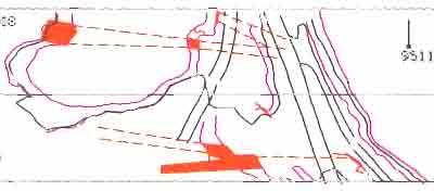
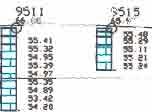
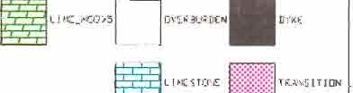
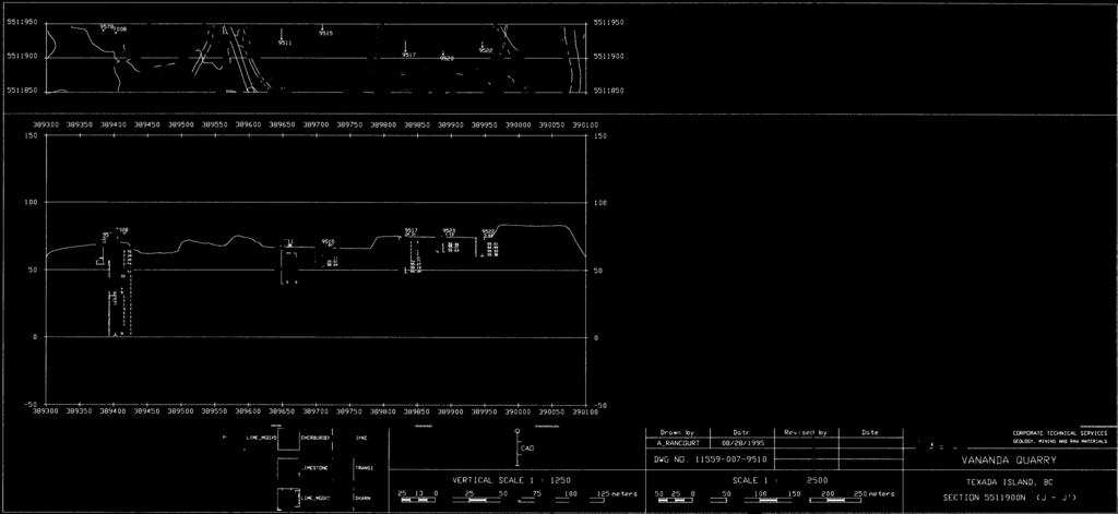
232
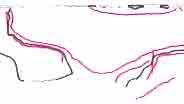
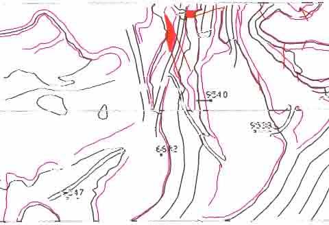
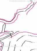
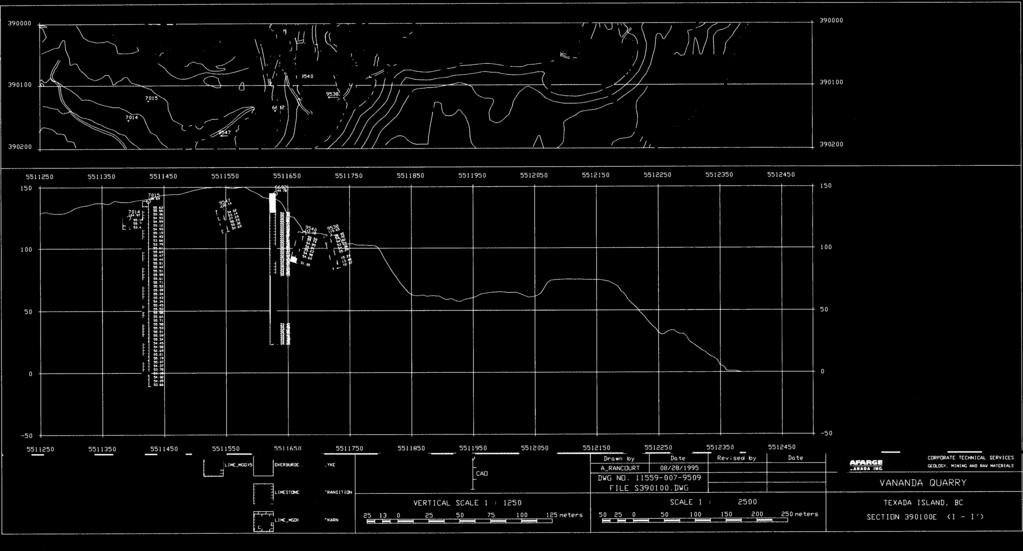
233
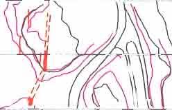
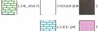
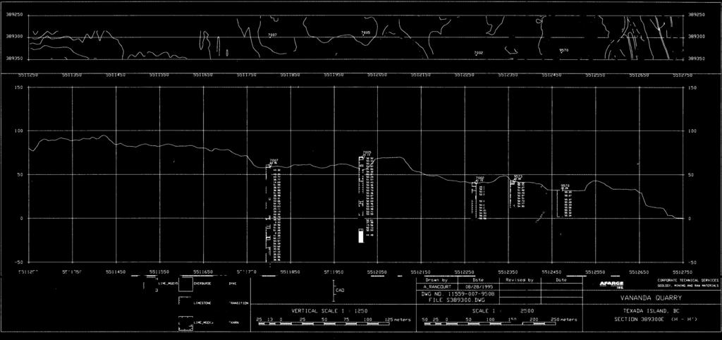
234
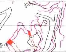
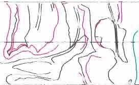
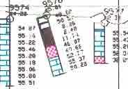
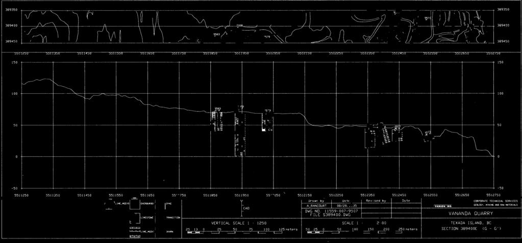
235
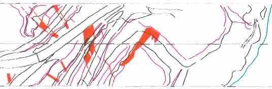
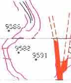
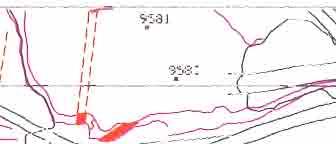
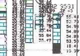
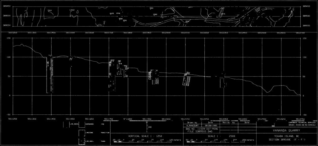
236
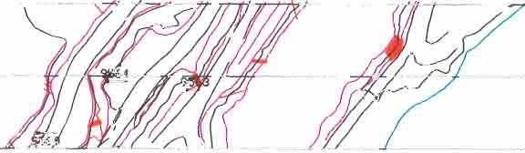
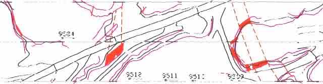
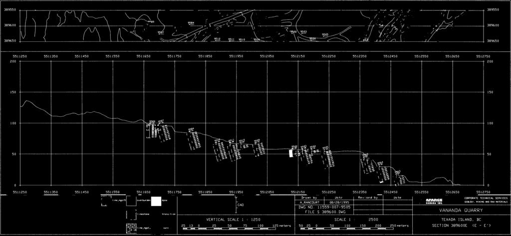
237
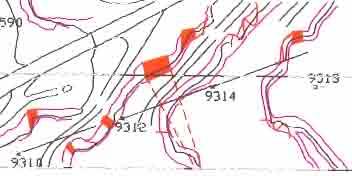
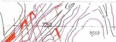
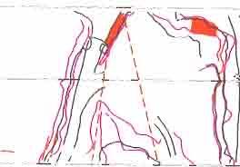
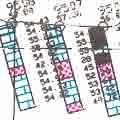

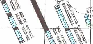
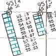
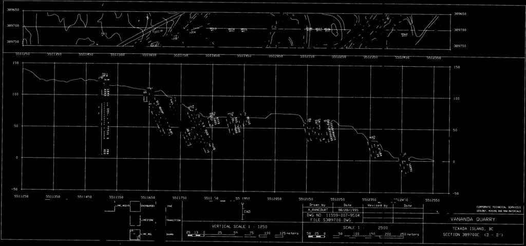
238
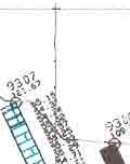
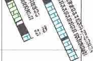
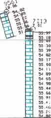
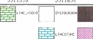
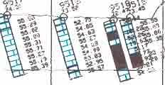
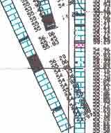
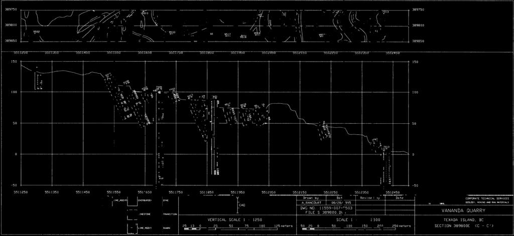
239
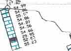
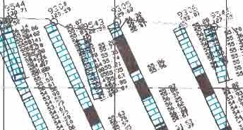
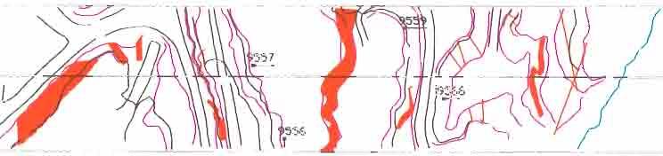
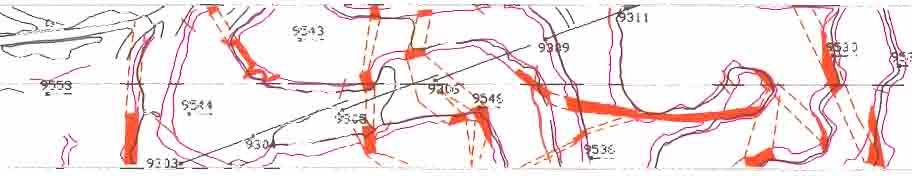
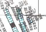
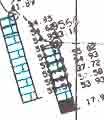
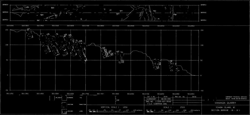
240
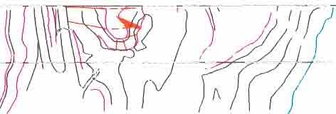
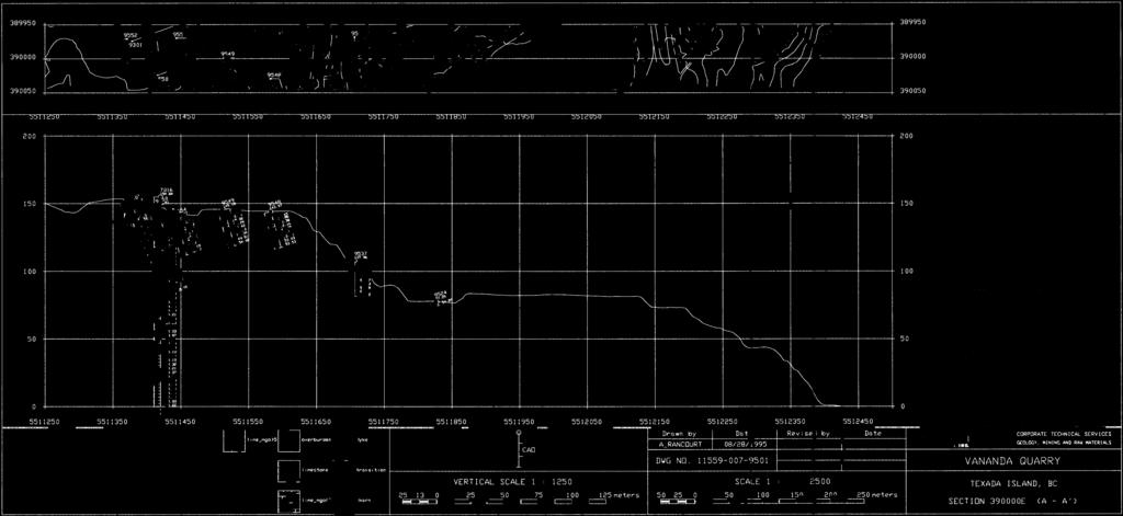
241
242 F. w
243 ANNEX4.3 Vananda Quarry Topographical Map Scale 1 :2,500
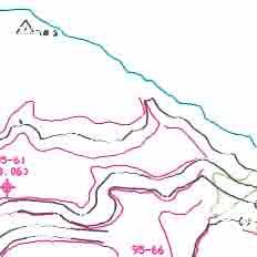
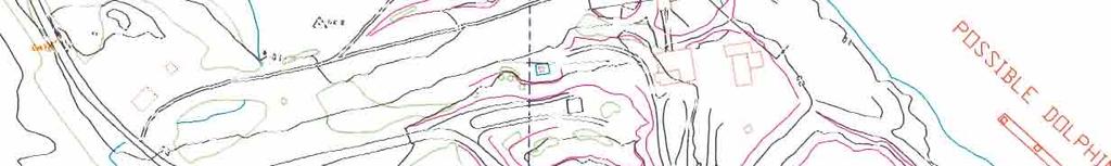
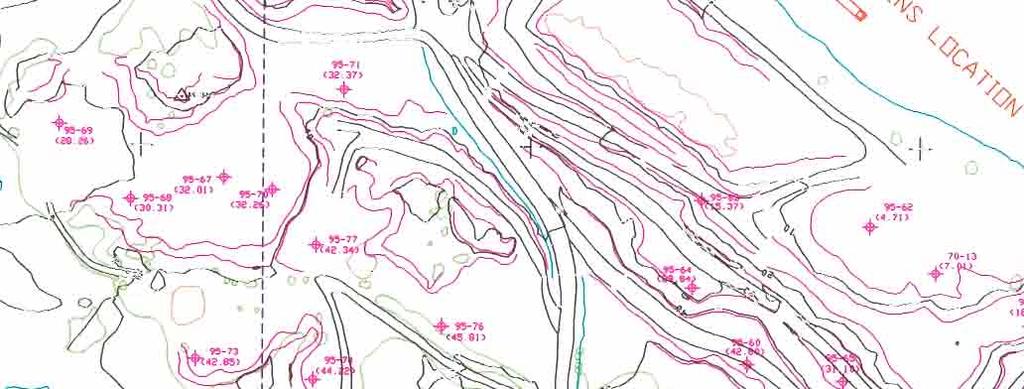
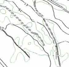
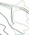
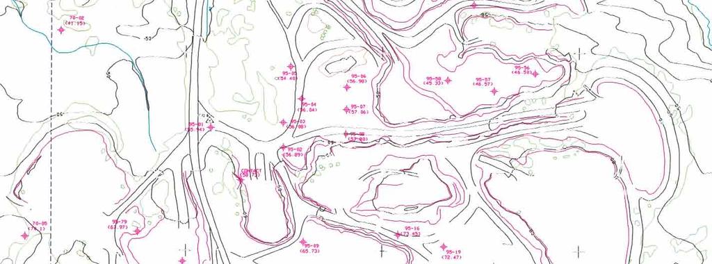
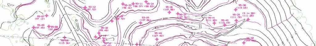
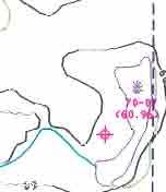
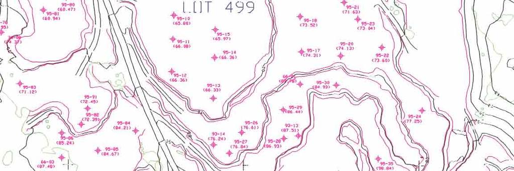
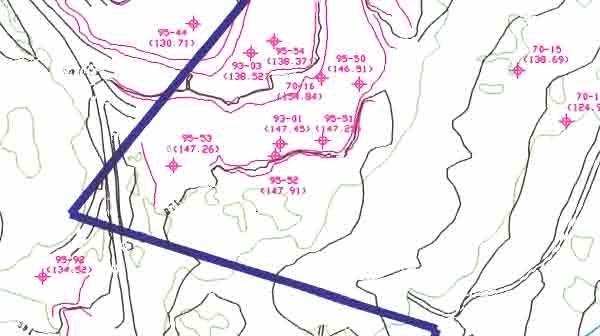

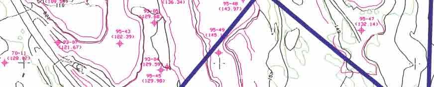
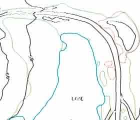
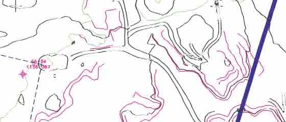
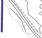
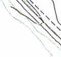
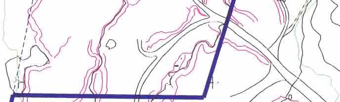
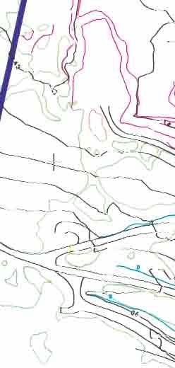
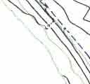
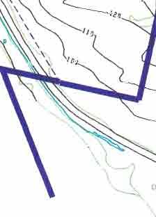
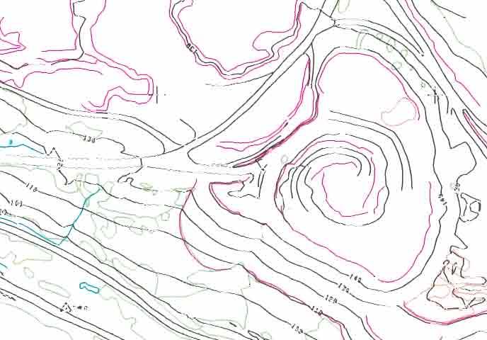
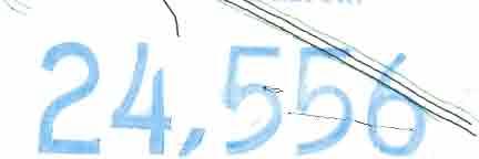
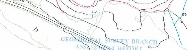
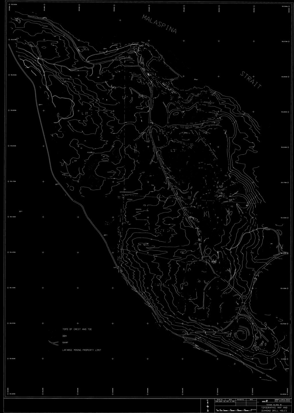
244
245
246 ANNEX 4.4 Vananda Quarry Geology Scale 1 :2,500
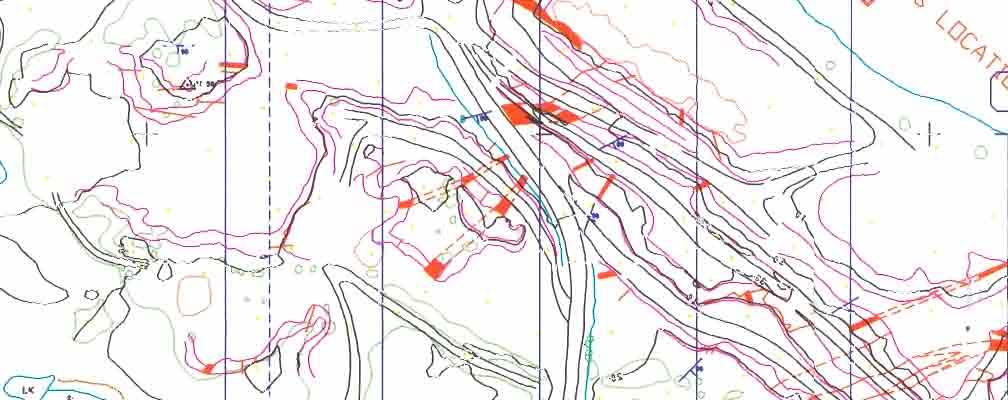
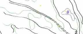
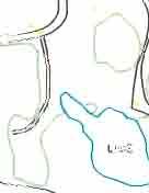
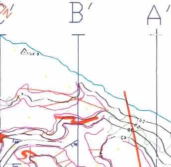
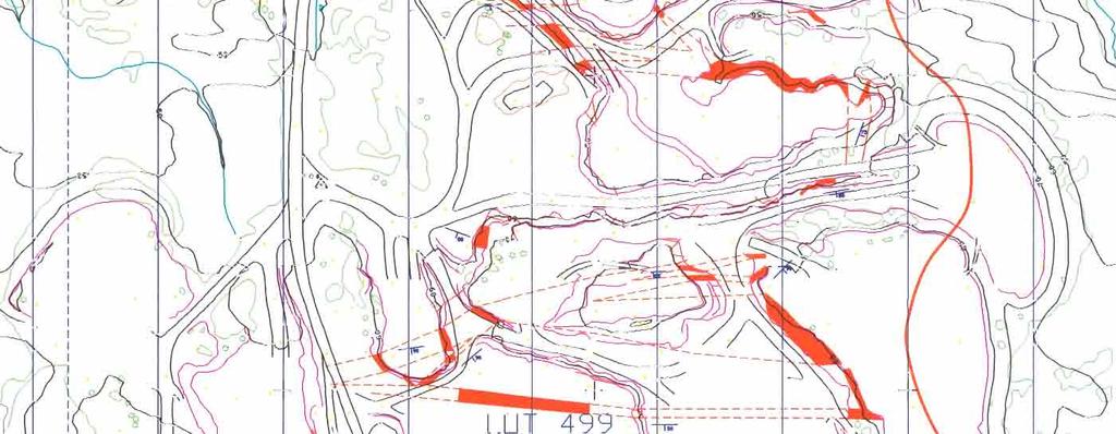
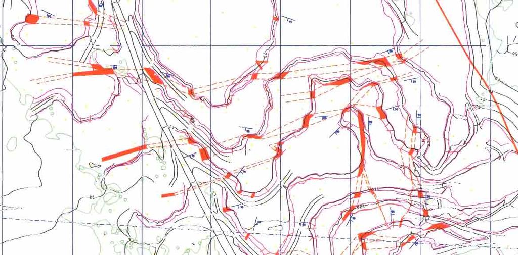
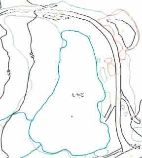
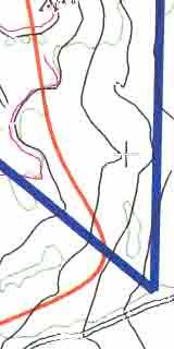
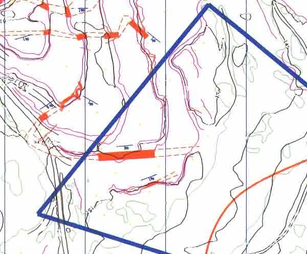
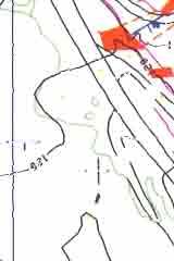
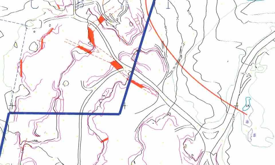
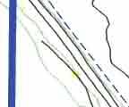
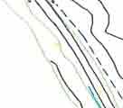
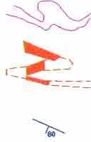
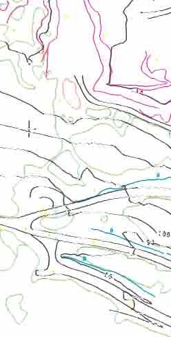
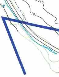
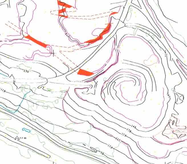
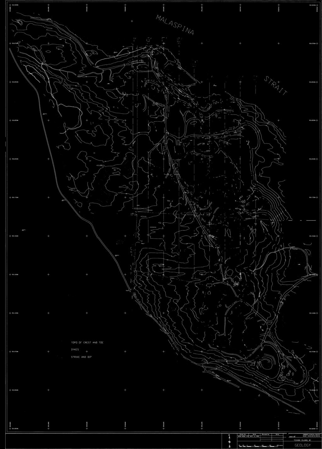
247
2013 GEOLOGICAL ASSESSMENT REPORT SHERIDAN HILL PROPERTY
 2013 GEOLOGICAL ASSESSMENT REPORT ON THE SHERIDAN HILL PROPERTY NEW WESTMINSTER MINING DIVISION BRITISH COLUMBIA NTS 092G07 49 16 31 NORTH LATITUDE, 122 39 48 WEST LONGITUDE PREPARED FOR Sheridan Hill
Geological Report on Limestone Exploration of Mudhvay Sub-block B, Lakhpat Taluka, Kachchh District, Gujarat. Executive Summary
 Geological Report on Limestone Exploration of Mudhvay Sub-block B, Lakhpat Taluka, Kachchh District, Gujarat Executive Summary Prepared for Commissioner of Geology & Mining Government of Gujarat Prepared
ASSESSMENT REPORT MAGNETOMETER SURVEY GOLDEN ROD, GOLDEN ROD #2. Long.: General Delivery, Vananda, B. C.
 ASSESSMENT REPORT MAGNETOMETER SURVEY GOLDEN ROD, GOLDEN ROD #2 t=/ NTS 92~110w Lat.: Long.: 49O 44' N 124O 34' W Owner: E. Johanson General Delivery, Vananda, B. C. Operator: Rhyolite Resources I nc.
Oil Shale Resource in Mae Sot Basin, Thailand
 Oil Shale Resource in Mae Sot Basin, Thailand By Apiradee Suwannathong Department of Mineral Resources 27 th Oil Shale Symposium October 18, 2007 Colorado School of Mines Golden, Colorado 1 Outlines Distribution
GEOLOGICAL MAPPING OF SKARNS ON THE SHEEP AND EWE CLAIMS, TURNAGAIN RIVER, B.C. DURING THE 1979 SUMMER SEASON
 GEOLOGICAL MAPPING OF SKARNS ON THE SHEEP AND EWE CLAIMS, TURNAGAIN RIVER, B.C. DURING THE 1979 SUMMER SEASON CLAIMS: Sheep 1 to 4 Ewe 1, 3, 4 to 8 Lamb 12 Fraction Liard Mining Division, B.C. NTS 104
7 miles West of Kamloops, B.C.
 MINERAL RESOURCES BRANCH ASSEWAENT RiPORT of hole # 78-11 NO. drilled on the ZZ # 18 Claim of China Commercial Corporation Ltd situated 7 miles West of Kamloops, B.C. in the Kamloops Mining Division D.R.
OSISKO METALS INTERSECTS 10.49% ZINC+LEAD OVER METRES AND 12.15% ZINC+LEAD OVER METRES AT PINE POINT
 OSISKO METALS INTERSECTS 10.49% ZINC+LEAD OVER 22.84 METRES AND 12.15% ZINC+LEAD OVER 17.00 METRES AT PINE POINT (Montreal November 19, 2018) Osisko Metals Incorporated (the Company or Osisko Metals )
..!I AXE CLAIMS ON THE. for RICHCORE EXPLORATIONS LTO. GREENWOOD MINING DIVISION BRITISH COLUMBIA. Latitude 49O 30"; Longitude 118' 30'W NTS 82E/9W
 ON THE AXE CLAIMS for RICHCORE EXPLORATIONS LTO. GREENWOOD MINING DIVISION BRITISH COLUMBIA Latitude 49O 30"; Longitude 118' 30'W NTS 82E/9W... -... ~ i.,...._.'..!i Vancouver, B.C. September, 1980 P.
CONTANGO ORE, INC. Contango ORE Announces Results of 2012 Exploration Program
 CONTANGO ORE, INC. NEWS RELEASE Contango ORE Announces Results of 2012 Exploration Program December 6, 2012 HOUSTON, TEXAS Contango ORE, Inc. (CTGO.PK) announced today the preliminary results on a portion
The Kennady North Project Investor Presentation Q2 2017
 The Kennady North Project Investor Presentation Q2 2017 Forward Looking Statement This presentation may contain forward-looking statements. These forward-looking statements are made as of the date of the
Geological Report on Limestone Exploration of Mudhvay Sub-block A, Lakhpat Taluka, Kachchh District, Gujarat. Executive Summary
 Geological Report on Limestone Exploration of Mudhvay Sub-block A, Lakhpat Taluka, Kachchh District, Gujarat Executive Summary Prepared for Commissioner of Geology & Mining Government of Gujarat Prepared
Grassy Mountain Project Malheur County, Oregon: A Summary
 Oregon Department of Geology and Mineral Industries Grassy Mountain Project Malheur County, Oregon: A Summary Bob Houston, RG Hydrocarbon & Metallic Ore Geologist Grassy Mountain 0 Calico, 2017 1 Sherry
GEOLOGICAL MAPPING REPORT ON THE ASH MINERAL CLAIM OSOYOOS MINING DIVISION ASHNOLA RIVER MAP SHEET NTS M092,H019 MCBRIDE CREEK AREA, ASHNOLA RIVER,
 GEOLOGICAL MAPPING REPORT ON THE ASH MINERAL CLAIM OSOYOOS MINING DIVISION ASHNOLA RIVER MAP SHEET NTS M092,H019 LATITUDE 49 o O6, LONGITUDE 120 o 22 MCBRIDE CREEK AREA, ASHNOLA RIVER, KEREMEOS, B.C. CANADA
Introducti on. Land Survey. Geomagnetic Survey. Geomagnetic Results and Interpretati ons - Conclusions and Recommendations C
 m M 42A86SW8281 63.42 PRICE 010 C O H T E H l 42A86SW828I 63.42 PRICE 010C Introducti on Land Survey Geomagnetic Survey Geomagnetic Results and Interpretati ons - Conclusions and Recommendations - - -
Summary of Rover Metals Geologic Mapping Program at the Up Town Gold Project, Northwest Territories
 October 13, 2017 Summary of Rover Metals Geologic Mapping Program at the Up Town Gold Project, Northwest Territories Vancouver, British Columbia, Canada - Rover Metals Corp., Rover, is pleased to provide
Drilling program commences on Cloncurry and Mount Isa projects
 1P P May UASX/Media Announcement st 2009 Drilling program commences on Cloncurry and Mount Isa projects Key Points 1,700 metres reverse circulation drilling program over two prospects on untested geochemical,
Geological report on Limestone Exploration of Goyla Block, Abadasa Taluka, Kachchh District, Gujarat. Executive Summary
 Geological report on Limestone Exploration of Goyla Block, Abadasa Taluka, Kachchh District, Gujarat Executive Summary Prepared for Commissioner of Geology & Mining Government of Gujarat Prepared by Geovale
A New Direction. Copper-Gold Deposit at Thor TSX.V:COL. August 11, May 2013
 A New Direction Copper-Gold Deposit at Thor August 11, 2016 May 2013 TSX.V:COL FORWARD LOOKING STATEMENTS This presentation includes certain forward-looking information or forward-looking statements for
CONSULTING GEOLOGICAL 8: MINING ENGINEERS STINGS STREET DA V6E 2E9 GEOPHYSICAL SURVEY SILVER QUEEN 2 ZEBALLOS AREA. B.C.
 DOLMAGE CAMPBELL & ASSOCIATES (1 975) LTD. CONSULTING GEOLOGICAL 8: MINING ENGINEERS STINGS STREET DA V6E 2E9 '' 1E O L 0 G I C A.L B'x;&a:f2:#& 'SESSMENT REPObT 12, Assessment RESOURCES LTD. 111 ReDort
GEOSYNTEC CONSULTANTS
 GEOSYNTEC CONSULTANTS 2100 Main Street, Suite 150 Huntington Beach, CA 92648 USA Tel (714) 969-0800 Fax (714) 969-0820 15 February 2006 Ms. Tamara Zeier, P.E. Project Manager Project Navigator, Ltd. One
GEOPHYSICAL REPORT THE CAVZ CLAIMS
 GEOPHYSICAL REPORT Magnetometer Survey on THE CAVZ CLAIMS CAVZ M.C.'s 1 to 12, 15 to 26, 29 to 40, 45 to 54 Trail Peak, Omineca M.D. 13 miles northeast of Fort Babine 550 ) 126 S.E. by G.Podolsky J.Russell
SIXTH SCHEDULE REPUBLIC OF SOUTH SUDAN MINISTRY OF PETROLEUM, MINING THE MINING (MINERAL TITLE) REGULATIONS 2015
 REGULATIONS 2015") SIXTH SCHEDULE REPUBLIC OF SOUTH SUDAN MINISTRY OF PETROLEUM, MINING THE MINING ACT, 2012 THE MINING (MINERAL TITLE) REGULATIONS 2015 Guidelines should be prepared by the Directorate of Mineral Development
SIXTH SCHEDULE REPUBLIC OF SOUTH SUDAN MINISTRY OF PETROLEUM, MINING THE MINING ACT, 2012 THE MINING (MINERAL TITLE) REGULATIONS 2015 Guidelines should be prepared by the Directorate of Mineral Development
CORPORATE UPDATE. Feasibility Study being finalised for completion towards the end of April.
 16 March 2018 Company Announcement Officer ASX Limited 20 Bridge Street SYDNEY NSW 2000 Highlights CORPORATE UPDATE Inaugural Bowdens Reserve Statement due early April. Feasibility Study being finalised
MINERAL MOUNTAIN RESOURCES LTD. MMV.TSX-V
 MINERAL MOUNTAIN RESOURCES LTD. 201-1416 West 8 th Avenue Vancouver, B.C. V6H 1E1 T: 604-714-0111 F: 604-714-1119 MMV.TSX-V NEWS RELEASE March 3, 2011 No. 2011-04 MINERAL MOUNTAIN DRILLS 3.17 g/t OVER
National Instrument Technical Report
 National Instrument 43-101Technical Report Pigeon River Property Hartington Township Ontario, Canada Thunder Bay Mining Division, NTS 42A4 Geology Updated Technical Report UTM: Zone 16, 277134m E, 5332229m
NOA ASSESSMENT HARRIS QUARRY MENDOCINO COUNTY, CALIFORNIA TABLE OF CONTENTS
 NOA ASSESSMENT HARRIS QUARRY MENDOCINO COUNTY, CALIFORNIA TABLE OF CONTENTS Introduction... 1 Scope of Services... 1 Project Location and Description... 1 Geologic Setting... 1 Regional Geology... 1 Site
I PRELIMINARY MAGNETOMETER SURVEY
 .REPORT O N I PRELIMINARY MAGNETOMETER SURVEY and GEOLOGICAL RECONNAISSANCE L AND K GROUP OF CLAIMS Located 8 Miles East of Princeton, B. C. Similkameen Mining Division Lat. 49' 27' N. Long. 120' 16' W
490 20' 30" North Latitude ' 30" West Longitude
 _._.. I CONSULTING GEOLOGISTS 605-602 WEST HASTINGS STREET, VANCOUVER, B.C. V6B 1P2 TELEPHONE: (604) 689-5533 6 I F: ASSESSMENT REPORT ON THE PATSY 1 MINERAL CLAIM ' '?%2% I WHISTLE CREEK, HEDLEY ARE L-l-
PHYSICAL WORK REPORT. the BAY CLAIMS. Omineca Mining Division Smithers, British Columbia N.T.S. 93E 13E/W
 PHYSICAL WORK REPORT the BAY CLAIMS Omineca Mining Division Smithers, British Columbia a N.T.S. 93E 13E/W LATITUDE: 53 57 00 N I LONGITUDE: 127 45 OO W for Home Ventures Ltd. 1201-675 West Hastings Street
Queensland Mining Corporation Limited
 Queensland Mining Corporation Limited ABN 61 109 962 469 ASX Release 29 th July 2011 Drilling Commenced at Duck Creek Copper-Gold Project, Cloncurry, North-west Queensland Highlights RC drilling has commenced
GEOPHYSICAL REPORT INDUCED POLARIZATION/RESISTMTY SURVEYS. on behalf of TEESHIN REOURCES LTD Argus Road. Oakville, Ontario L6J 354
 GEOPHYSICAL REPORT INDUCED POLARIZATION/RESISTMTY SURVEYS DOME MOUNTAIN PROPERTY, SMITHERS AREA CHRIS, APRIL 1, APRIL 2, APRIL 3, AND MAG 1 CLAIMS CMINECA MINING DMSION, BRITISH COLUMBIA Latitude: 546
Structure contours on Bone Spring Formation (Lower Permian), Delaware Basin
, Delaware Basin") Structure contours on Bone Spring Formation (Lower Permian), Delaware Basin By Ronald F. Broadhead and Lewis Gillard New Mexico Bureau of Geology and Mineral Resources, a division of New Mexico Tech, Socorro
Structure contours on Bone Spring Formation (Lower Permian), Delaware Basin By Ronald F. Broadhead and Lewis Gillard New Mexico Bureau of Geology and Mineral Resources, a division of New Mexico Tech, Socorro
n3a 92 C- /.I 4 tr November 6, 1979 J. F. MclNTYRE, P.ENG. CONSU LTlNG MINING ENGl NEER Map #92C-16 TRANS PACIFIC VENTURES LTD.
 TELEPHONE : 5 9 6-1331 J. F. MclNTYRE, P.ENG. CONSU LTlNG MINING ENGl NEER 6466 CAGELDU CRESCENT DELTA, B.C. CANADA TRANS PACIFIC VENTURES LTD. c i. SAMPLING AND GEOPHYSICAL REPORT CAP CLAIM, VICTORIA
News Release No GOLD AND COPPER MINERALIZATION DISCOVERED DURING PHASE 2 EXPLORATION AT THE MCBRIDE PROPERTY
 November 19, 2018 TSX Venture Exchange Listed Frankfurt Exchange Listed News Release No. 303-2018 GOLD AND COPPER MINERALIZATION DISCOVERED DURING PHASE 2 EXPLORATION AT THE MCBRIDE PROPERTY Vancouver,
Blox, Inc. Announces New Drilling Target Defined at Mansounia Gold Project.
 Blox, Inc. Announces New Drilling Target Defined at Mansounia Gold Project. Vancouver, British Columbia, July 6, 2018 Blox, Inc. (OTCQB: BLXX), ( Blox or the Company ) is pleased to announce that a new
July Exploring for Canadian Gold in the Rainy River District of Ontario
 July 2013 Exploring for Canadian Gold in the Rainy River District of Ontario 1 Forward Looking Statements Some of the statements in this document may be deemed to be "forward-looking statements". All statements
BALFOUR MINING LTD. (N.P.L.) HAM GROUP 92-P-6, CLINTON M. D.8 B. C. Lat 51 17'N, GEOCHEMICAL REPORT. V. CUKOR, P. Eng.
 HAM GROUP 92-P-6, CLINTON M. D.8 B. C. Lat 51 17'N, GEOCHEMICAL REPORT. V. CUKOR, P. Eng.") 34q '7 BALFOUR MINING LTD. (N.P.L.) HAM GROUP 92-P-6, CLINTON M. D.8 B. C. Lat 51 17'N, Long 12lo14'W GEOCHEMICAL REPORT, V. CUKOR, P. Eng. January 31, 1972 TABLE OF CONTENTS 1. INTRODUCTION 2. PROPERTY,
34q '7 BALFOUR MINING LTD. (N.P.L.) HAM GROUP 92-P-6, CLINTON M. D.8 B. C. Lat 51 17'N, Long 12lo14'W GEOCHEMICAL REPORT, V. CUKOR, P. Eng. January 31, 1972 TABLE OF CONTENTS 1. INTRODUCTION 2. PROPERTY,
The Snap lake diamond deposit - mineable resource.
 Title Page: Author: Designation: Affiliation: Address: Tel: Email: The Snap lake diamond deposit - mineable resource. Fanie Nel Senior Mineral Resource Analyst De Beers Consolidated Mines Mineral Resource
Fireball Ridge. a western Nevada Miocene low sulfidation epithermal project TSX.V:REN
 Fireball Ridge a western Nevada Miocene low sulfidation epithermal project TSX.V:REN R E F I N I N G T H E A R T O F M I N E R A L E X P L O R A T I O N FORWARD LOOKING STATEMENT This presentation contains
List of Sites in District 2C Source Number
 List of Sites in District 2C Source Number 03-002-1...2 03-021-1...4 03-070-1...6 14-002-1...8 14-007-1...10 14-011-1...12 14-015-1...14 26-004-1...16 26-007-1...18 26-010-1...20 26-013-1...22 26-036-1...24
Mt Carrington Porphyry Copper Exploration Program Commencement of Electrical Geophysics
 ASX and Media Release: 11 November 2014 ASX Code: WRM Mt Carrington Porphyry Copper Exploration Program Commencement of Electrical Geophysics White Rock Minerals Ltd (White Rock) announces it will shortly
Detour Gold Reports Drilling Results from Lower Detour
 December 17, 2015 NEWS RELEASE Detour Gold Reports Drilling Results from Lower Detour Detour Gold Corporation (TSX: DGC) ( Detour Gold or the Company ) reports final results from its 2015 summer drilling
Assessment Work Report. on the Geophysical Surveys carried out over the
 Assessment Work Report on the Geophysical Surveys carried out over the PINE GROUP of Mineral Claims 951-J-15-W Lillooet Mining Division Goldbridge, B.C. Long 122 48' Lat. 50 48' by Levon Resources Ltd.
GEOLOGY AND MINERAL RESOURCES OF INDIAN RESERVE 26
 ) 41HI3NW94I4 I R NO 26 1*A1 MANITOULIN ISLAND 010 -f?;. GEOLOGY AND MINERAL RESOURCES OF INDIAN RESERVE 26 September 16, 1975 D. G. Innes, Resident Geologist Sudbury District Ministry of Natural Resources
For personal use only
 ACN 097 088 689 ASX Announcement 1 EXPLORATION SUCCESS CONTINUES AT RAVENSWOOD RC drilling targeting shallow portions of Welcome breccia returns a number of significant new results including: 7m @ 7.84g/t
1 CLAIMS GEOPHYSICAL REPORT ON BOYAL SITUATE NORTHEAST OF TILLICUM MOUNTAIN GOLD AREA BURTON - NAKUSP SIQCAEJ MINING DIVISION
 GEOPHYSICAL REPORT ON BOYAL 1 CLAIMS SITUATE NORTHEAST OF TILLICUM MOUNTAIN GOLD AREA BURTON - NAKUSP SIQCAEJ MINING DIVISION CONSULTING GEOLOGIST AUGUST 1983 VANCOUVER B *C INDEX INTRODUCTION ooa,.eoaaa.aaaoaaooaoa~ao~o
UNION MINIERE EXPLORATIONS AND MINING CORPORATION LIMITED ASSESSMENT REPORT ON FITINAT MINERAL CLAIM. Alberni Mining Division Record No.
 M F )( UNION MINIERE EXPLORATIONS AND MINING CORPORATION LIMITED Suite 200, 4299 Canada Way, Burnaby, B.C. V5G 1 H4 Telephone (604) 437-9491 ASSESSMENT REPORT ON GEOCHEMICAL SOIL SURVEYS AND ROCKSAMPLING
ASSESSMENT REPORT ON THE PEAVINE PROJECT. DGW & Associates # Alberni Street, Vancouver, British Columbia, V6E 4V2
 ASSESSMENT REPORT ON THE PEAVINE PROJECT KAMLOOPS MINING DIVISION BRITISH COLUMBIA NTS 082M 12 Latitude 51 36' 19.0"North -- Longitude --119 47' 27.0"West UTM Zone 11, NAD 83 5720827N 306744E Prepared
The Copperstone Project: Operational update October 2015
 The Copperstone Project: Operational update October 2015 Work Programme Completed Since the last operational update, the following work has been carried out for the Copperstone project: Detailed geological
SUPPLEMENT TO MAGNETOMETER 6 ELECTROMAGNETIC SURVEY REPORT. DATED NOVEMBER l, 1973 CIGLEN INVESTMENTS LIMITED CLAIMS GROUP BAD VERMILLION LAKE AREA
 ^ A R l ^ 1974 010 PROJECTS UNIT SUPPLEMENT TO MAGNETOMETER 6 ELECTROMAGNETIC SURVEY REPORT DATED NOVEMBER l, 1973 CIGLEN INVESTMENTS LIMITED CLAIMS GROUP BAD VERMILLION LAKE AREA DISTRICT OF RAINY RIVER
555 Burrard Street, Suite 375, Vancouver, B.C. V7X 1M June 13, 2017 SBB NR SBB TSX
 555 Burrard Street, Suite 375, Vancouver, B.C. V7X 1M7 604.998.4175 June 13, 2017 SBB NR-17-12 SBB TSX SABINA GOLD & SILVER INTERCEPTS LLAMA MINERALIZATION 300 METERS DOWN PLUNGE OF CURRENT RESOURCE Deposit
LATEST EXPLORATION RESULTS CONFIRM GOLD AND COPPER VALUES INCREASE WITH DEPTH AT TURQUOISE HILL DISCOVERY IN MONGOLIA
 For Immediate Release January 21, 2002 LATEST EXPLORATION RESULTS CONFIRM GOLD AND COPPER VALUES INCREASE WITH DEPTH AT TURQUOISE HILL DISCOVERY IN MONGOLIA MONGOLIA Ivanhoe Mines Chairman Robert Friedland
DRILLING REPORT ON THE HIGHLAND VALLEY, KAMLOOPS MINING DIVISION, OWNED BY GAZA MINES LTD., NEW JERICHO DEVELOPMENT AND TECK CORPORATION
 DRILLING REPORT ON THE GAZA 1 AND JERICHO 1 AND 2 MINERAL CLAIMS / (RECORD NUMBERS 159, 492 AND 161) HIGHLAND VALLEY, KAMLOOPS MINING DIVISION, LATITUDE 50' 26' N; LONGITUDE 120' 55' W; NTS 92-I/7W OWNED
For personal use only
 ASX ANNOUNCEMENT 17 May 2013 Exploration update for the Kagera Nickel Project Kibaran Resources Limited (ASX: KNL) is pleased to provide an update of the nickel sulphide (NiS) study being undertaken on
Mineral Exploration Network (Finland) Ltd.
 Ltd.") Mineral Exploration Network (Finland) Ltd. March 2013 www.men-finland.com Mineral Exploration Network (Finland) Ltd. Mineral Exploration Network (Finland) Ltd. is a UK-based junior company formed in early
Mineral Exploration Network (Finland) Ltd. March 2013 www.men-finland.com Mineral Exploration Network (Finland) Ltd. Mineral Exploration Network (Finland) Ltd. is a UK-based junior company formed in early
CANARC RESOURCE CORP Howe Street Vancouver, BC V6C 2T6. News Release
 CANARC RESOURCE CORP. 810-625 Howe Street Vancouver, BC V6C 2T6 T: 604.685.9700 F: 604.6685-9744 www.canarc.net CCM: TSX CRCUF: OTCQX News Release Canarc Intersects Significant Gold Mineralization in First
STRONG GOLD IN SOIL ANOMALY OUTLINED AT MARY HARRISON PROJECT HIGHLIGHTS
 National Stock Exchange of Australia Company Announcements Level 2, 117 Scott Street Newcastle NSW 2300 25 th January 2013 STRONG GOLD IN SOIL ANOMALY OUTLINED AT MARY HARRISON PROJECT HIGHLIGHTS 100m
KATINGAN RIA COAL RESOURCE UPGRADE
 Company Announcements ASX Limited Exchange Plaza 2 The Esplanade PERTH WA 6000 By Electronic Lodgement 14 February 2013 Dear Sir/Madam KATINGAN RIA COAL RESOURCE UPGRADE Fivefold increase in Measured and
SEAL LAKE COPPER-SILVER
 SEAL LAKE COPPER-SILVER www.playfairmining.com Copper-Silver in Canada Jan. 11, 2011 Cautionary Disclaimer: Forward-looking Statements Certain statements contained herein regarding the Company and its
PERCY CONTRACTING SERVICES LTD.
 GEOLOGICAL REPORT ON TEN PLACER LEASES (3139, 3140, 3141, 3142, 3143, 3144, 3145, 3146, 3147, 3148) MOREHEAD CREEK CARIB00 MINING DIVISION, B.C. 938/12W (52 38 N, 121 47 W) For PERCY CONTRACTING SERVICES
For personal use only
 27 August 208 Exceptional High-Grade Vanadium Intersections Returned from the Airijoki Project, Northern Sweden Highlights Geochemical assaying of historical drill holes on the Airijoki Project in northern
INVESTOR PRESENTATION
 INVESTOR PRESENTATION Canadian Zeolite Corp. 2017 Disclaimer This presentation may contain forward-looking statements which reflect the Company s current expectations regarding the future results of operations,
MBA Gold Corp. Resources to Reserves to Production: A business approach to mining North American Gold
 MBA Gold Corp. Resources to Reserves to Production: A business approach to mining North American Gold OUR MISSION MBA Gold was created to provide investors with an opportunity to participate in the current
For personal use only
 ABN 79 106 879 690 7 October 2011 The Manager Companies ASX Limited 20 Bridge Street SYDNEY NSW 2000 (6 pages by email) Dear Madam, Multiple zones intersected including 123 metres at 0.61 g/t Gold and
SOUTHWEST & NORTHWEST EXPLORATION PROJECTS BINGHAM CANYON MINING DISTRICT
 SOUTHWEST & NORTHWEST EXPLORATION PROJECTS BINGHAM CANYON MINING DISTRICT SALT LAKE AND TOOELE COUNTIES, UTAH SUMMARY FRIDAY, MARCH 20, 2009 1 Tooele County Salt Lake County GOOGLE EARTH September, 2006
Canadian National Railways tracks from the foot bridge across the. Thompson River from the Trans Canada Highway. A pick-up truck was used
 Canadian National Railways tracks from the foot bridge across the Thompson River from the Trans Canada Highway. A pick-up truck was used on the highway side and a h-wheel drive Jeep was transported by
KEMESS SOUTH MAGNETIC MODELING. CONDOR CONSULTING, INC. OCTOBER 2017
 KEMESS SOUTH MAGNETIC MODELING. CONDOR CONSULTING, INC. OCTOBER 2017 INTRODUCTION Magnetic data in the vicinity of the Kemess South Mine in the Yukon has been analyzed and modeled in order to try to explain
Cape Breton Island Mineral Inventory Studies: A Sandstone Quarry Development Opportunity at Graham River (NTS 11F/14), Inverness County
, Inverness County") Report of Activities 2001 23 Cape Breton Island Mineral Inventory Studies: A Sandstone Quarry Development Opportunity at Graham River (NTS 11F/14), Inverness County G. J. DeMont and J. E. Hawken Compilation
Report of Activities 2001 23 Cape Breton Island Mineral Inventory Studies: A Sandstone Quarry Development Opportunity at Graham River (NTS 11F/14), Inverness County G. J. DeMont and J. E. Hawken Compilation
5.11 MINERAL RESOURCES
 5.11 This section of the Draft PEIR evaluates the potential impacts to mineral resources in the Plan Area from implementation of the Clovis General Plan and Development Code Update (proposed project).
NEWS RELEASE August 10, 2017
 NEWS RELEASE August 10, 2017 Ashanti Gold Continues to Intersect Gold at Gourbassi East, Kossanto East Project, Mali 25 metres of 1.53 g/t gold (including 3 metres of 7.95 g/t gold), and 13 metres of 2.34
April Exploring for Canadian Gold in the Rainy River District of Ontario
 April 2013 Exploring for Canadian Gold in the Rainy River District of Ontario 1 Forward Looking Statements This presentation may contain forward-looking statements including but not limited to comments
ASSESSMENT REPORT TITLE PAGE AND SUMMARY
 ASSESSMENT REPORT TITLE PAGE AND SUMMARY TITLE OF REPORT: 2016 Prospecting Report Midas Claim TOTAL COST: $314.61 AUTHOR(S): Giacomo Grassi SIGNATURE(S): NOTICE OF WORK PERMIT NUMBER(S)/DATE(S): STATEMENT
CHAKETMA TRENCH ASSAYS CONFIRM HISTORIC RESULTS HIGHLIGHTS. Historic trench results: -
 Celamin Holdings N.L ACN 139 255 771 ABN 82 139 255 771 Suite 304, 22 St Kilda Road, St Kilda, VIC 3182 Phone: (03) 9692 7222 Fax: (03) 9529 8057 Email generaladmin@victoriangoldmines.com.au 13 February
ASSESSMENT REPORT TITLE PAGE AND SUMMARY
 ASSESSMENT REPORT TITLE PAGE AND SUMMARY TITLE OF REPORT: 2016 Prospecting Report Sphynx Claim TOTAL COST: $167.56 AUTHOR(S): Giacomo Grassi SIGNATURE(S): NOTICE OF WORK PERMIT NUMBER(S)/DATE(S): STATEMENT
AUGUST CANADA MONGOLIA VIETNAM 1780, D.H.L.
 1753.6 g/t Au AUGUST 2011 CANADA MONGOLIA VIETNAM Ste. 1780, 400 Burrard St. Ste. 503-504 D.H.L. Building #220-ATS Hotel, 33B Pham Ngu Lao St. Vancouver, B.C. V6C 3A6 Peace Ave. 15-A Hoan Kiem District
PRECIOUS METALS. owner. JMT Services Corp. GEOCHPlICAL SAMPLING CHELASLIE WCE, NORTH CENTRAL, B.C. OMINECA MINING DIVISION NTS 93F/5E & 6W
 PRECIOUS METALS REPORT ON 1980 RECONNAISSANCE GEOCHPlICAL SAMPLING CHELASLIE WCE, NORTH CENTRAL, B.C. OMINECA MINING DIVISION NTS 93F/5E & 6W LATITUDE 53O28 N LONGITUDE 125O31 W DATES Qp WORK: JULY 10
GEOPHYSICAL REPORT ON AN INDUCED POLAR.IZATION SURVEY
 GEOPHYSICAL REPORT ON AN INDUCED POLAR.IZATION SURVEY T & V Claim Groups some 12 miles Northwest of Babine Lake, B.C. Latitude 55' 26'N Longitude 126' 35'W AUTHOR: Glen E. White, Chief Geophysicist,a,
For personal use only
 ANNOUNCEMENT TO THE AUSTRALIAN SECURITIES EXCHANGE: 28 NOVEMBER 2012 DRILLING UPDATE MABILO PROJECT The Directors of Sierra Mining Limited ( Sierra ) are pleased to announce further results from reconnaissance
Alligator commences drilling of TCC4 uranium prospect in Arnhem Land, NT 4 September 2018
 Alligator commences drilling of TCC4 uranium prospect in Arnhem Land, NT 4 September 2018 Highlights The TCC4 prospect represents Alligators most advanced untested undercover uranium target with a large
TOPOGRAPHICAL SURVEY REPORT ON THE GREENDROP PROPERTY NEAR CHILLIWACK, B.C. 92-H-3/W
 TOPOGRAPHICAL SURVEY REPORT ON THE GREENDROP PROPERTY NEW WESTMINSTER M.D. NEAR CHILLIWACK, B.C. 92-H-3/W Location: The central pap of the claims is located at coordinates 49 08'N, latitude by 121 26'W,
ENCOURAGING DRILLING RESULTS RECORDED AT BERNARD GOLD PROJECT. EXPLORATION PROGRAM TO BE ACCELERATED.
 3 February 2010 ASX ANNOUNCEMENT ENCOURAGING DRILLING RESULTS RECORDED AT BERNARD GOLD PROJECT. EXPLORATION PROGRAM TO BE ACCELERATED. HIGHLIGHTS Grass roots gold play with encouraging initial drilling
IVANHOE MINES LTD ACQUIRES FOUR NEW COPPER-GOLD PROJECTS IN MONGOLIA
 News Release October 15, 2001 IVANHOE MINES LTD ACQUIRES FOUR NEW COPPER-GOLD PROJECTS IN MONGOLIA SINGAPORE - Ivanhoe Mines Chairman Robert Friedland and Senior Vice-President, Exploration, Douglas Kirwin
FALCO PACIFIC COMPLETES INITIAL MODEL FOR THE HORNE 5 GOLD/SILVER/ZINC/COPPER DEPOSIT
 For Immediate Release NR 13-10 FALCO PACIFIC COMPLETES INITIAL MODEL FOR THE HORNE 5 GOLD/SILVER/ZINC/COPPER DEPOSIT (Vancouver, BC, September 16, 2013) Falco Pacific Resource Group Inc. ( Falco Pacific
VR COMMENCES 2018 SURFACE EXPLORATION AT JUNCTION; GRAVITY ANOMALY CONFIRMS THE DOWN-DIP POTENTIAL OF COPPER-SILVER VEINS
 VR COMMENCES 2018 SURFACE EXPLORATION AT JUNCTION; GRAVITY ANOMALY CONFIRMS THE DOWN-DIP POTENTIAL OF COPPER-SILVER VEINS NR-18-08 April 17, 2018, Vancouver, B.C.: VR Resources Ltd. (TSX.V: VRR, FSE: 5VR),
INDIAN BUREAU OF MINES MINERALS DEVELOPMEMT AND REGULATION DIVISION MCDR inspection REPORT Jabalpur regional office
 INDIAN BUREAU OF MINES MINERALS DEVELOPMEMT AND REGULATION DIVISION MCDR inspection REPORT Jabalpur regional office Mine file No : MP/KTN/LST-96 (i) Name of the Inspecting : Officer and ID No. (ii) Designation
COMINCO LTD. HORIZONTAL LOOP EM AND MAGNETIC SURVEYS ON SHA. CLAIMS 1, 2, 7 and 8 NELSON AND FORT STEELE MINING DIVISIONS, B.C.
 COMINCO LTD. EXPLORATION WESTERN DISTRICT NTS: 82-F/1 HORIZONTAL LOOP EM AND MAGNETIC SURVEYS ON SHA CLAIMS 1, 2, 7 and 8 - ASSESSMENT REPORT - NELSON AND FORT STEELE MINING DIVISIONS, B.C. Latitude Longitude
Mineral Exploration Network (Finland) Ltd.
 Ltd.") Mineral Exploration Network (Finland) Ltd. Karelian Gold Project 202 г. www.men-finland.com Mineral Exploration Network (Finland) Ltd. Mineral Exploration Network (Finland) Ltd. is a UK-based junior company
Mineral Exploration Network (Finland) Ltd. Karelian Gold Project 202 г. www.men-finland.com Mineral Exploration Network (Finland) Ltd. Mineral Exploration Network (Finland) Ltd. is a UK-based junior company
Spring 2018 Drill Program
 VANCOUVER, BC / April 5, 2018 / Margaret Lake Diamonds Inc. (TSX-V: DIA; FSE: M85) ("Margaret Lake" or the "Company") is pleased to report preparations are now underway to commence a diamond drill program
News Release. Trilogy Metals Reports Additional Drilling Results from the Bornite Project
 TSX, NYSE American Symbol: TMQ News Release Trilogy Metals Reports Additional Drilling Results from the Bornite Project November 19, 2018 - Vancouver, British Columbia Trilogy Metals Inc. (TSX/NYSE American:
NEWS RELEASE. September 30 th, Trading Symbols: GTP (TSX-V) P01 (FRANKFURT) COLTF (OTC Pink)
 P01 (FRANKFURT) COLTF (OTC Pink)") NEWS RELEASE September 30 th, 2015 Trading Symbols: GTP (TSX-V) P01 (FRANKFURT) COLTF (OTC Pink) Colt Resources intersects 2.29% Cu over a 7.30 metres true width at its Miguel Vacas copper project in its
NEWS RELEASE September 30 th, 2015 Trading Symbols: GTP (TSX-V) P01 (FRANKFURT) COLTF (OTC Pink) Colt Resources intersects 2.29% Cu over a 7.30 metres true width at its Miguel Vacas copper project in its
Summary and status of the Reinfjord Exploration Project and other exploration targets within the Seiland Igneous Province
 Summary and status of the Reinfjord Exploration Project and other exploration targets within the Seiland Igneous Province By Nordic Mining s Exploration Manager Mona Schanche, 1 st of August 2013 Background
Beekeeper Property The Geology South of Mint Lake. Cariboo Mining Division
 Beekeeper Property The Geology South of Mint Lake NTS: 93A/6 Cariboo Mining Division Claims: Beekeeper 1 #I2055 Beekeeper 2 #3892 Beekeeper 3 #7895 Beekeeper 4 #8503 Latitude: Longitude: 52 degrees 24
Copper Reef to Drill Massive Sulphide Targets in Flin Flon
 12 Mitchell Road Tel: (204) 687-3500 Flin Flon, MB, R8A 1N1 CZC.CSE Fax: (204) 687-4762 copperreef.com February 28, 2019. Copper Reef to Drill Massive Sulphide Targets in Flin Flon Copper Reef Mining Corporation
Serengeti Resources Inc GEOCHEMICAL REPORT ON THE SHADOW PROPERTY a.
 Serengeti Resources Inc. 2004 GEOCHEMICAL REPORT ON THE SHADOW PROPERTY a. Located in the Johanson Lake Area Omenica Mining Division NTS 94D/9 6 degrees and 32 minutes North Latitude 126 degrees and 2
West Pender Street Vancouver, BC V6C 2V6 Tel: Fax: TSX-V: GBR NEWS RELEASE
 1020 800 West Pender Street Vancouver, BC V6C 2V6 Tel: 604-646-8354 Fax: 604-646-4526 TSX-V: GBR NEWS RELEASE Great Bear Drills Hinge Zone Extensions - Results Include New 42 m Wide Zone with Multiple
Goldsource Coal Intercepts in Saskatchewan
 Goldsource Coal Intercepts in Saskatchewan For Immediate Release VANCOUVER, B.C. April 28, 2008 Goldsource Mines Inc. (the Company ) wishes to make the following statements regarding the intercepts of
COMMANDER RESOURCES LTD SOUTH VOISEY S BAY NI-CU-CO PROJECT LABRADOR
 COMMANDER RESOURCES LTD SOUTH VOISEY S BAY NI-CU-CO PROJECT LABRADOR May 2017 CORPORATE DISCLOSURE Disclaimer The information contained herein, while obtained from sources which we believe are reliable,
A B C PAD A HIGHLIGHTS
 Murchison Minerals Intercepts 12.30% Zinc, 0.70% Copper, 0.18% Lead and 42.03 g/t Silver 14.97% ZnEq over 6.37 Metres and Extends Known Limits of Brabant McKenzie VMS Deposit June 25, 2018 (Toronto, Ontario):
CERRO PRIETO PROJECT MINERAL CONCESSIONS LOCATION AND ACCESS
 Cerro Prieto CERRO PRIETO PROJECT MINERAL CONCESSIONS The Cerro Prieto Project is comprised of three mining exploitation concessions encompassing 2,723 hectares in northern Sonora, Mexico. Oroco holds
SESE MEASURED RESOURCE EXCEEDS 650MT COAL
 For electronic distribution 15 th August 2012 SESE MEASURED RESOURCE EXCEEDS 650MT COAL Highlights: Initial Measured Resource at Sese calculated at 651Mt coal. Sese Coal & Power Project: Resource Summary