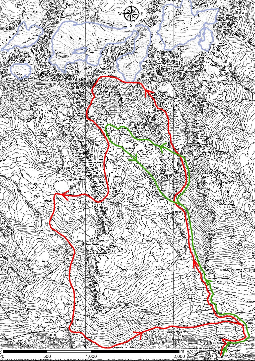
Vendredi 27 août : les glaciers rocheux de la Valpisella, les plus spectaculaires de la vallée.
|
|
|
- Bernadette Reynolds
- 6 years ago
- Views:
Transcription
1 Vendredi 27 août : les glaciers rocheux de la Valpisella, les plus spectaculaires de la vallée. groupe A : Refuge des Forni, Valpisella, glaciers rocheux, arête du Cima dei Forni (3233 m, passages faciles de rocher ), Vallée de la Manzina, Refuge des Forni (5-6 heures) groupe B : Refuge des Forni, Valpisella, glaciers rocheux, Refuge des Forni (3-4 heures) PERIGLACIAL MORPHOLOGY IN VAL PISELLA (by C. Smiraglia & G. Guglielmin) General Val Pisella is situated in Valfurva (Upper Valtellina, Ortles-Cevedale Group, Italian Alps). It is a secondary valley, hanging on the main valley of Valfurva, which it joins with a north-south direction, enclosed between peaks: the Sasso della Manzina (2920 m) to the west, the Cime dei Forni ( m) to the north and Monte dei Forni (3054 m) to the east. The bedrock throughout the entire valley is formed of Paleozoic Bormio phyllites, which, in turn, consist of Quartz phyllites with sericite and chlorite; garnetbearing phyllites; and schists with chlorite. Quartzites and crystalline limestones are intercalated. The Bormio Phyllites formation is cross-cut by quartz-diorites and porphyry dykes. The entire metamorphic bedrock of Val Pisella proves to be fractured and probably also faulted. The main fracture systems are oriented in two main directions: WNW- ESE, that is, approximately along the Valfurva axis, and NNW-SSE, particularly evident on the rock surfaces modelled by the ice. The morphology of Val Pisella is essentially derived from the action of glacial and periglacial processes. At present, glacial morphogenesis is inactive. In fact, the last small glacier, the Ghiacciaio delle Cime dei Forni, contained within the eastern cirque of the valley head, has been considered as extinct for at least thirty years now. The glacier became a dead glacier between 1949 and 1957 (DESIO, 1967). Even the small glacieret that occupied the cirque bottom until the mid 1980s, has now disappeared. The snow-, frozen ground- and frost-related processes are instead the processes that are now creating the most significant changes on the slopes. In the highest part of the basin, the intensity of the freezing-thawing action is markedly facilitated by the bedrock that is structurally subject to weathering. Large areas are covered by cryoclasts, which are generally found in cones bordering the base of the steepest slopes. Rock glaciers are numerous and they are distributed within two main altitude zones, a lower one ranging between 2550 and 2650 m (altitudes of the fronts) and an upper one ranging between 2825 e 3000 m. The former are situated in the cirques of the upper valley, whereas the latter are found in the intermediate-low sector of the left slope of the valley. There are also numerous other examples of cryonivation environment forms at the level of meso- and microforms, such as hummocks, stone pavements, sorted stripes, ploughing blocks; the latter being very frequent on the debris cover in the lower Val Pisella. The other forms are found mainly in the upper valley, between the upper sector of the rock glaciers and the frontal moraines. 1
2 2
3 Climate There are no meteorological stations located in Val Pisella. Therefore, the climatic data refer to the two nearest stations, the Forni station, located at 2120 m slightly further west from the Val Pisella outlet into Valfurva and the S. Caterina Valfurva station, situated at 1740 m in altitude, about 5 km downstream from the previous one. Some data recorded at the two meteorological stations may serve to illustrate the general climatic conditions: Forni S.Caterina Valfurva Mean annual air temperature 1.5 C 3.7 C Mean air temperature in January -6.8 C -6.3 C Mean air temperature in July 11.1 C 12.9 C Days without thaw Days with frost Days without frost Mean annual precipitation 807 mm 874 mm Equilibrium line altitude (Ortles-C3050 m Group) The rock glaciers in Val Pisella The rock glaciers definitely constitute one of the principal and most interesting features of the periglacial morphology of Val Pisella. Six main forms were identified. The following are the main topographical characteristics observed on the aerial photographs and by means of land surveys: location front basin max. surface aspect max width length m slope degr probable activity elevation m altitude m sq. m m Cirque SE uncertain Cirque S inactive Cirque SE active Valley S active Cirque S active Valley SW inactive The three rock glaciers defined as active in the table are located in the two cirques which cut the upper sector of Val Pisella. They are connected by wide slopes covered by debris and are almost totally devoid of vegetation showing a classical morphology with ogive-shaped transversal ridges and abrupt fronts (with a steepness of up to 45 ), where mostly fine material appears at the surface. The western and central rock glaciers have a lobate morphology, while the eastern one has a tongue which coming from the upper cirque and stretching down-valley. Some morphological, topographical and geophysical observations have been carried out on these rock glaciers, starting from 1985, especially within the sphere of the work being done by the Gruppo Nazionale Geografia Fisica e Geomorfologia-Sezione Glaciologia (National Working Group on Physical Geography and Geomorphology - Glaciology Section). Temperature measurements, resistivity, ph measurements and total hardness of the water coming directly from rock glaciers held to be active and inactive, of direct meltwater from snow, from in situ rock 3
4 hydrologic networks and surface circulation water (GNGF, 1987) were all recorded in order to obtain indications on the rock glacier activity and the presence of ice within the rock glacier.). The most significant results concerned the temperatures. In fact, waters from the rock glaciers held to be active due to morphological evidence and vegetation, showed temperatures well below 1 C, in some cases reaching temperatures similar to snow water, but always different from the water circulating in the rocks (higher by more than 3 C) and the water circulating on the surface (temperature ranging between 3 C and 12 C). The waters from the rock glaciers held to be inactive have temperatures slightly lower than 2 C. For the eastern Val Pisella rock glaciers, measurements of flow velocity were also recorded as indicated at 50 points distributed over the surface, from an altitude of 2848 m up to 2970 m (Smiraglia, 1989). The measured values vary from a few centimeters up to a maximum of 40 cm per year, with the highest values recorded in the upper sector and at the center of the rock glacier. Towards the valley and the outer margins, the rate decreases and approaches zero at the terminus. In the belt of the ogive-shaped transversal ridges, the flow is compressing. In the upper part of the rock glacier, flow lines parallel to the longitudinal axis diverge approaching the front, where their trend is almost transversal, as is also revealed by the transversal trend of the long axis of many boulders. On the rock glaciers in Val Pisella and on those found in the nearby Valle della Manzina, some geoelectrical surveys were carried out also in collaboration with some French colleagues (D. Fabre, M. Evin and A. Assier) in order to check the presence, type and thickness of the ice within the rock glaciers. Six vertical electric soundings (V.E.S.) were conducted on the eastern rock glacier in Val Pisella. These V.E.S. are distributed from the moraine in the upper part of the cirque down to the frontal part of the rock glacier; almost all were carried out with simmetrical Schlumberger quadripole trends in direction transversal to the flow of the rock glacier. The VP3 and VP4 curves (fig. a) show a degradated permafrost (18-25 k m) with a thickness that increases towards the frontal part of the rock glacier (about 20 m). The figure b and c show the great difference that exist from the electric curves obtained on the moraine (VPF1) or in the upper part of the rock glacier (VPF2) (where only a thin layer of unfrozen diamicton occurs) and the curves obtained in the frontal part of the rock glacier (VPF4 and VPF3) that show the presence of degradated permafrost about m thick. The general conditions of thermal degradation of the permafrost which are still present in the rock glaciers of Val Pisella and those in Valle della Manzina, (Smiraglia et Alii, 1994) conflicts with the temperature levels that could be obtained by applying a gradient of 0.64 C/100 m for the zone falling between 2800 and 3000 m, starting from the mean annual temperatures from the Forni and S. Caterina Valfurva stations. With the data from the former station, at the altitudes indicated, the mean annual temperatures would range between -2.8 and C, whereas with the data from the latter, the values would range between 3.7 and -4.4 C. It is well known that the annual isotherm of -2 C is considered to be a fundamental climatic parameter for determining the limits of rock glacier activity. In this specific case, the fundamental parameter seems to be the aspect, which is clearly southern for all of the rock glaciers, and which must have markedly raised the altitude limit along which the rock glaciers should retain appreciable amounts of permafrost. 4


5 1 Moraine tardiglaciaire à l embouchure de la Valpisella 2 Glacier rocheux inactive de la Valpisella 3 Monte Tresero e Monte S. Matteo, vue de la Valpisella 4 Glacier du Forni, vue de la Valpisella 5 Glacier rocheux Est de Valpisella 6 Glacier rocheux Central de Valpisella 5


6 7 Glacier rocheux Ouest de Valpisella 8 Glacier rocheux Ouest de Valpisella 6


7 9 Glacier rocheux de la Manzina Prospection électrique sur les glaciers rocheux de la Valpisella 7
Glaciers form wherever snow and ice can accumulate High latitudes High mountains at low latitudes Ice temperatures vary among glaciers Warm
 The Cryosphere Glaciers form wherever snow and ice can accumulate High latitudes High mountains at low latitudes Ice temperatures vary among glaciers Warm (temperate) glaciers: at pressure melting point,
The landforms of Svalbard
 The landforms of Svalbard Content Periglacial landforms -) ice-wedges -) rock glaciers -) pingos -) solifluction -) avalanches -) debris flows -) rock falls -) nivation -) aeolian landforms Glacial landforms
Periglacial Geomorphology
 Periglacial Geomorphology Periglacial Geomorphology Periglacial: literally means around glacial - term introduced in 1909 to describe landforms and processes around glaciated areas. Periglacial environments:
Match up the pictures and key terms
 Match up the pictures and key terms 1 Plucking Striations 3 Roche Mountonnees 2 Chatter Marks 4 What is the difference between plucking and abrasion? Glacial Processes Erosion, Weathering and Deposition
Some Periglacial Morphology in the Sagarmatha. (Everest) Region, Khumbu Himal*
 Region, Khumbu Himal*") Seppyo, 1976 S. Iwata 115 Some Periglacial Morphology in the Sagarmatha (Everest) Region, Khumbu Himal* Shuji Iwata** Abstract The periglacial morphology in the Sagarmatha region, Khumbu Himal, was surveyed
Seppyo, 1976 S. Iwata 115 Some Periglacial Morphology in the Sagarmatha (Everest) Region, Khumbu Himal* Shuji Iwata** Abstract The periglacial morphology in the Sagarmatha region, Khumbu Himal, was surveyed
2/23/2009. Visualizing Earth Science. Chapter Overview. Deserts and Drylands. Glaciers and Ice Sheets
 Visualizing Earth Science By Z. Merali and B. F. Skinner Chapter 6 Deserts, Glaciers and Ice Sheets Chapter Overview Deserts and Drylands Glaciers and Ice Sheets Deserts Geography Categorization of deserts
1. Any process that causes rock to crack or break into pieces is called physical weathering. Initial product = final product
 Weathering 1. Any process that causes rock to crack or break into pieces is called physical weathering. Initial product = final product End Result of physical weathering is increased surface area. 2. Physical
OBSERVING AND MAPPING THE ROCK STREAMS AND QUARRIES IN SOME MASSIFS FROM THE ROMANIAN CARPATHIANS BY MEANS OF SATELLITE IMAGES
 VASILE LOGHIN 371 OBSERVING AND MAPPING THE ROCK STREAMS AND QUARRIES IN SOME MASSIFS FROM THE ROMANIAN CARPATHIANS BY MEANS OF SATELLITE IMAGES Key words: rock streams, quarries, satellite images, Carpathians
4. What type of glacier forms in a sloping valley between rock walls? a. firn glacier b. ice sheet c. cirque d. alpine glacier
 Multiple Choice Questions 1. The term means the loss of snow and ice by evaporation and melting. a. sublimation b. ablation c. erosion d. abrasion 2. What condition must be met for a glacier to begin flowing
New Mexico Geological Society
 New Mexico Geological Society Downloaded from: http://nmgs.nmt.edu/publications/guidebooks/34 Rock glaciers on the west slope of South Baldy, Magdalena Mountains, Socorro County, New Mexico John W. Blagbrough
Glaciology (as opposed to Glacial Geology) Why important? What are glaciers? How do they work?
 Why important? What are glaciers? How do they work?") Glaciology (as opposed to Glacial Geology) Why important? What are glaciers? How do they work? Glaciers are important because of their role in creating glacial landscapes (erosional and depositional features).
Glaciology (as opposed to Glacial Geology) Why important? What are glaciers? How do they work? Glaciers are important because of their role in creating glacial landscapes (erosional and depositional features).
Prentice Hall EARTH SCIENCE
 Prentice Hall EARTH SCIENCE Tarbuck Lutgens Chapter 7 Glaciers, Desert, and Wind 7.1 Glaciers Types of Glaciers A glacier is a thick ice mass that forms above the snowline over hundreds or thousands of
Be able to understand the processes which occurred during the last ice age.
 Glaciation Learning Intentions Be able to understand the processes which occurred during the last ice age. Be able to describe and explain the formation of features formed during glacial periods. 1 Water
APPENDIX 1: EXTENDED SAMPLE INFORMATION.
 1 APPENDIX 1: EXTENDED SAMPLE INFORMATION. Location map of the giant bar between Inya and Little Jaloman (topographic map 1:50,000). The circle marks the sampling location. Giant bar boulders (location
PHYSICAL GEOGRAPHY. By Brett Lucas
 PHYSICAL GEOGRAPHY By Brett Lucas GLACIAL PROCESSES Glacial Processes The Impact of Glaciers on the Landscape Glaciations Past and Present Types of Glaciers Glacier Formation and Movement The Effects of
MASS MOVEMENTS, WIND, AND GLACIERS
 Date Period Name MASS MOVEMENTS, WIND, AND GLACIERS SECTION.1 Mass Movements In your textbook, read about mass movements. Use each of the terms below just once to complete the passage. avalanche creep
FROM CRYOSPHERE TO ANTHROPOGENIC IMPACTS
 FROM CRYOSPHERE Balázs Nagy Department of Physical Geography Eötvös Loránd University, Budapest TO ANTHROPOGENIC IMPACTS primary data and environmental applications: - summary of the Hungarian high altitude
The Cassiar Mountains
 The Cassiar Mountains Introduction Topography Dease Plateau Dease Lake, BC Stikine Ranges Eve Cone Mount Edziza Provincial Park Mount Ash, BC 2 125m Ketchika Ranges Muskwa- Ketchika Management Area Sifton
Figure 2.1: Constituent Area
 2 The Region 2.1 CONSTITUENT AREA The National Capital Region includes NCT-Delhi, nine districts of Haryana, six districts of Uttar Pradesh and one district of Rajasthan. Total area of the region is 34,144
Maximum Extent of Pleistocene Glaciation - 1/3 of land surface Most recent glacial maximum peaked 18,000 years ago and is considered to have ended
 Glaciers Maximum Extent of Pleistocene Glaciation - 1/3 of land surface Most recent glacial maximum peaked 18,000 years ago and is considered to have ended 10,000 B.P. Current Extent of Glaciation - about
Mass Movements, Wind, and Glaciers
 Mass Movements,, and Glaciers SECTION 8.1 Mass Movement at Earth s Surface In your textbook, read about mass movement. Use each of the terms below just once to complete the passage. avalanche creep landslide
Chapter 9 Notes: Ice and Glaciers, Wind and Deserts
 Chapter 9 Notes: Ice and Glaciers, Wind and Deserts *Glaciers and Glacial Features glacier is a mass of ice that moves over land under its own weight through the action of gravity Glacier Formation must
Lecture Outlines PowerPoint. Chapter 6 Earth Science 11e Tarbuck/Lutgens
 Lecture Outlines PowerPoint Chapter 6 Earth Science 11e Tarbuck/Lutgens 2006 Pearson Prentice Hall This work is protected by United States copyright laws and is provided solely for the use of instructors
Lecture 10 Glaciers and glaciation
 Lecture 10 Glaciers and glaciation Outline Importance of ice to people! Basics of glaciers formation, classification, mechanisms of movement Glacial landscapes erosion and deposition by glaciers and the
Chapter 5: Glaciers and Deserts
 I. Glaciers and Glaciation Chapter 5: Glaciers and Deserts A. A thick mass of ice that forms over land from the compaction and recrystallization of snow and shows evidence of past or present flow B. Types
Which process is represented by letter F? A) capillarity B) infiltration C) condensation D) vaporization
 capillarity B) infiltration C) condensation D) vaporization") 1. Water's covalent bond is due to A) water's ability to stick to stick to other materials B) a slight negative charge of O and positive charge of H C) an uneven sharing of electrons D) both B and C 2.
1. Water's covalent bond is due to A) water's ability to stick to stick to other materials B) a slight negative charge of O and positive charge of H C) an uneven sharing of electrons D) both B and C 2.
3. GEOLOGY. 3.1 Introduction. 3.2 Results and Discussion Regional Geology Surficial Geology Mine Study Area
 3. GEOLOGY 3.1 Introduction This chapter discusses the baseline study of the geology and mineralization characteristics of the mine study area. The study consolidates existing geological data and exploration
THE ACTION OF GLACIERS
 Surface processes THE ACTION OF GLACIERS Glaciers are enormous masses of ice which are formed due to accumulation, compaction and re-crystallisation of the snow deposited in very cold regions (the majority
Evidence for Permafrost on Long Island
 Evidence for Permafrost on Long Island By Vesna Kundic and Gilbert N. Hanson Department of Geosciences Stony Brook University Permafrost or permanently frozen ground is soil or rock that remains below
The elevations on the interior plateau generally vary between 300 and 650 meters with
 11 2. HYDROLOGICAL SETTING 2.1 Physical Features and Relief Labrador is bounded in the east by the Labrador Sea (Atlantic Ocean), in the west by the watershed divide, and in the south, for the most part,
Chapter 2. Wearing Down Landforms: Rivers and Ice. Physical Weathering
 Chapter 2 Wearing Down Landforms: Rivers and Ice Physical Weathering Weathering vs. Erosion Weathering is the breakdown of rock and minerals. Erosion is a two fold process that starts with 1) breakdown
Spring break reading. Glacial formation. Surface processes: Glaciers and deserts. The Control of Nature
 suggested Spring break reading The Control of Nature by John McPhee Surface processes: Glaciers and deserts describes our efforts to control three natural hazards: 1. The Mississippi Floods 2. The Heimaey
Electrical imaging techniques for hydrological and risk assessment studies
 Séminaire IPG le 9 mars 2006 Strasbourg Institute of Geophysics ETH Hoenggerberg CH-8093 Zurich Electrical imaging techniques for hydrological and risk assessment studies Laurent Marescot laurent@aug.ig.erdw.ethz.ch
Glacial Modification of Terrain
 Glacial Modification Part I Stupendous glaciers and crystal snowflakes -- every form of animate or inanimate existence leaves its impress upon the soul of man. 1 -Orison Swett Marden Glacial Modification
Modeling of Mountain Permafrost Distribution in the Semi-arid Chilean Andes
 www.atacamamb.com Modeling of Mountain Permafrost Distribution in the Semi-arid Chilean Andes Guillermo Azócar Sandoval Atacama Ambiente Consultores gazocar@atacamamb.com December 05, 2018 Ice in the Atacama
1. Which type of climate has the greatest amount of rock weathering caused by frost action? A) a wet climate in which temperatures remain below
 a wet climate in which temperatures remain below") 1. Which type of climate has the greatest amount of rock weathering caused by frost action? A) a wet climate in which temperatures remain below freezing B) a wet climate in which temperatures alternate
1. Which type of climate has the greatest amount of rock weathering caused by frost action? A) a wet climate in which temperatures remain below freezing B) a wet climate in which temperatures alternate
Weathering, Erosion and Deposition
 Weathering, Erosion and Deposition Shaping the Earth s Surface Weathering the process of breaking down rocks into smaller fragments Erosion the transport of rock fragments from one location to another
Name. 4. The diagram below shows a soil profile formed in an area of granite bedrock. Four different soil horizons, A, B, C, and D, are shown.
 Name 1. In the cross section of the hill shown below, which rock units are probably most resistant to weathering? 4. The diagram below shows a soil profile formed in an area of granite bedrock. Four different
 Page 1 of 9 Name: Base your answer to the question on the diagram below. The arrows show the direction in which sediment is being transported along the shoreline. A barrier beach has formed, creating a
Permafrost environment in the Yari-Hotaka Mountains, southern part of the Northern Japanese Alps
 Permafrost, Phillips, Springman & Arenson (eds) 23 Swets & Zeitlinger, Lisse, ISBN 9 589 582 7 Permafrost environment in the Yari-Hotaka Mountains, southern part of the Northern Japanese Alps M. Aoyama
USING GIS FOR AVALANCHE SUSCEPTIBILITY MAPPING IN RODNEI MOUNTAINS
 USING GIS FOR AVALANCHE SUSCEPTIBILITY MAPPING IN RODNEI MOUNTAINS IOANA SIMEA 1 ABSTRACT. Using GIS for avalanche susceptibility mapping in Rodnei Mountains. This case study combines GIS methods with
Down-stream process transition (f (q s ) = 1)
 = 1)") Down-stream process transition (f (q s ) = 1) Detachment Limited S d >> S t Transport Limited Channel Gradient (m/m) 10-1 Stochastic Variation { Detachment Limited Equilibrium Slope S d = k sd A -θ d S
Down-stream process transition (f (q s ) = 1) Detachment Limited S d >> S t Transport Limited Channel Gradient (m/m) 10-1 Stochastic Variation { Detachment Limited Equilibrium Slope S d = k sd A -θ d S
Glaciers. (Shaping Earth s Surface, Part 6) Science 330 Summer 2005
 Science 330 Summer 2005") Glaciers (Shaping Earth s Surface, Part 6) Science 330 Summer 2005 1 Glaciers Glaciers are parts of two basic cycles Hydrologic cycle Rock cycle Glacier a thick mass of ice that originates on land from
Glaciers (Shaping Earth s Surface, Part 6) Science 330 Summer 2005 1 Glaciers Glaciers are parts of two basic cycles Hydrologic cycle Rock cycle Glacier a thick mass of ice that originates on land from
Unit 3 Review - Surface Processes
 Unit 3 Review - Surface Processes 1. Why is the surface of Mercury covered with meteor impact craters, while Earth s surface has relatively few craters? A) Mercury is larger than Earth, so it gets hit
Weathering, Erosion, Deposition
 Weathering, Erosion, Deposition The breakdown of rocks at or near the Earth s Surface. Physical Chemical - The breakdown of rock into smaller pieces without chemical change. - Dominant in moist /cold conditions
Appendix 1 Debris Flow Inventory in Maps (Sect. 3.3)
") Appendix 1 Debris Flow Inventory in Maps (Sect. 3.3) Springer International Publishing Switzerland 2016 K. Sattler, Periglacial Preconditioning of Debris Flows in the Southern Alps, New Zealand, Springer
Appendix 1 Debris Flow Inventory in Maps (Sect. 3.3) Springer International Publishing Switzerland 2016 K. Sattler, Periglacial Preconditioning of Debris Flows in the Southern Alps, New Zealand, Springer
Surface Processes on the Earth. Rocks, Weathering, Erosion and Soil
 Surface Processes on the Earth Rocks, Weathering, Erosion and Soil ROCKS AND ROCK CYCLE Rock types Three main types of rock Igneous Metamorphic Sedimentary Igneous Form when magma or lava cools and hardens
UNIT 4: Earth Science Chapter 21: Earth s Changing Surface (pages )
") CORNELL NOTES Directions: You must create a minimum of 5 questions in this column per page (average). Use these to study your notes and prepare for tests and quizzes. Notes will be turned in to your teacher
CORNELL NOTES Directions: You must create a minimum of 5 questions in this column per page (average). Use these to study your notes and prepare for tests and quizzes. Notes will be turned in to your teacher
4. The map below shows a meandering stream. Points A, B, C, and D represent locations along the stream bottom.
 1. Sediment is deposited as a river enters a lake because the A) velocity of the river decreases B) force of gravity decreases C) volume of water increases D) slope of the river increases 2. Which diagram
Glaciers Earth 9th Edition Chapter 18 Glaciers: summary in haiku form Key Concepts Glaciers Glaciers Glaciers Glaciers
 1 2 3 4 5 6 7 8 9 10 11 12 13 14 Earth 9 th Edition Chapter 18 : summary in haiku form Ten thousand years thence big glaciers began to melt - called "global warming." Key Concepts and types of glaciers.
How do glaciers form?
 Glaciers What is a Glacier? A large mass of moving ice that exists year round is called a glacier. Glaciers are formed when snowfall exceeds snow melt year after year Snow and ice remain on the ground
THICKNESS OF MINERAL COVERS ON THE ICE-MORAINE RIDGES AND AN ACTIVE LAYER OF PERMAFROST ON SPITSBERGEN
 Marek GRZEŚ Department of Hydrology and Waler Economy Institute of Geography, Mikołaj Kopernik University Fredry 6/8 87-100 Toruń, POLAND tel/fax: (056) 273-03 Wyprawy Geograficzne na Spitsbergen UMCS,
The PermaSense Project. Computer Engineering and Networks Lab, ETH Zurich Geography Department, University of Zurich
 The PermaSense Project Computer Engineering and Networks Lab, ETH Zurich Geography Department, University of Zurich PermaSense Aims and Vision Interdisciplinary geo-science and engineering collaboration
HIGH-MOUNTAIN PERMAFROST IN THE AUSTRIAN ALPS (EUROPE)
") HIGH-MOUNTAIN PERMAFROST IN THE AUSTRIAN ALPS (EUROPE) Gerhard Karl Lieb Institute of Geography University of Graz Heinrichstrasse 36 A-8010 Graz e-mail: gerhard.lieb@kfunigraz.ac.at Abstract Permafrost
HIGH-MOUNTAIN PERMAFROST IN THE AUSTRIAN ALPS (EUROPE) Gerhard Karl Lieb Institute of Geography University of Graz Heinrichstrasse 36 A-8010 Graz e-mail: gerhard.lieb@kfunigraz.ac.at Abstract Permafrost
GEOL.3250 Geology for Engineers Glacial Geology
 GEOL.3250 Geology for Engineers Glacial Geology NAME Part I: Continental Glaciation Continental glaciers are large ice sheets that cover substantial portions of the land area. In the region of accumulation
Foundations of Earth Science, 6e Lutgens, Tarbuck, & Tasa
 Foundations of Earth Science, 6e Lutgens, Tarbuck, & Tasa Glacial and Arid Landscapes Foundations, 6e - Chapter 4 Stan Hatfield Southwestern Illinois College Glaciers Glaciers are parts of two basic cycles
Sensitivity and responses to climate change in the Subantarctic periglacial environment
 Sensitivity and responses to climate change in the Subantarctic periglacial environment Permafrost, Phillips, Springman & Arenson (eds) Swets & Zeitlinger, Lisse, ISBN 9 589 58 7 J. Boelhouwers Department
Page 1. Name:
 Name: 1) Which event is the best example of erosion? dissolving of rock particles on a limestone gravestone by acid rain breaking apart of shale as a result of water freezing in a crack rolling of a pebble
Name: Mid-Year Review #2 SAR
 Name: Mid-Year Review #2 SAR Base your answers to questions 1 through 3 on on the diagram below, which shows laboratory materials used for an investigation of the effects of sediment size on permeability,
What is a Glacier? Types of Glaciers
 Alpine & Continental Glaciers Glacial Mass Balance Glacial Ice Formation Glacial Movement & Erosion Erosional and Depositional Landforms The Pleistocene Epoch Geomorphology of SW Manitoba Chapter 17 1
Name: Which rock layers appear to be most resistant to weathering? A) A, C, and E B) B and D
 A, C, and E B) B and D") Name: 1) The formation of soil is primarily the result of A) stream deposition and runoff B) precipitation and wind erosion C) stream erosion and mass movement D) weathering and biological activity 2)
Name: 1) The formation of soil is primarily the result of A) stream deposition and runoff B) precipitation and wind erosion C) stream erosion and mass movement D) weathering and biological activity 2)
Radiometer measurements from a helicopter on Muragl block glacier
 Radiometer measurements from a helicopter on Muragl block glacier Daniel Vonder Müehll and Hansueli Gubler As a final test within Pace 1, but a preliminary test for air borne BTS measurements using a radiometer,
3 Erosion and Deposition by Ice
 CHAPTER 12 3 Erosion and Deposition by Ice SECTION Agents of Erosion and Deposition BEFORE YOU READ After you read this section, you should be able to answer these questions: What are glaciers? How do
Areal Scour vs. Selective Linear Erosion
 Erosional Forms and Landscapes Erosional Landscapes Areal Scour vs. Selective Linear Erosion Cirques Form and Morphology Many Forms Red Tarn Cirque Basin English Lake District Red Tarn Cirque Basin, English
Figure 1 The map shows the top view of a meandering stream as it enters a lake. At which points along the stream are erosion and deposition dominant?
 1. In which type of climate does chemical weathering usually occur most rapidly? 1. hot and dry 3. cold and dry 2. hot and wet 4. cold and wet 2. Figure 1 The map shows the top view of a meandering stream
What do you think? Should the development of cold environments continue? Is there a better way?
 What do you think? Should the development of cold environments continue? Is there a better way? What is the future for the development of cold environments? d) With reference to one or more examples, Outline
1/6/ th Grade Earth s Surface. Chapter 3: Erosion and Deposition. Lesson 1 (Mass Movement)
") Lesson 1 (Mass Movement) 7 th Grade Earth s Surface Chapter 3: Erosion and Deposition Weathering the chemical and physical processes that break down rock at Earth s surface Mechanical weathering when rock
Lesson 1 (Mass Movement) 7 th Grade Earth s Surface Chapter 3: Erosion and Deposition Weathering the chemical and physical processes that break down rock at Earth s surface Mechanical weathering when rock
Amazing Ice: Glaciers and Ice Ages
 Amazing Ice: Glaciers and Ice Ages Updated by: Rick Oches, Professor of Geology & Environmental Sciences Bentley University Waltham, Massachusetts Based on slides prepared by: Ronald L. Parker, Senior
TAKE HOME EXAM 8R - Geology
 Name Period Date TAKE HOME EXAM 8R - Geology PART 1 - Multiple Choice 1. A volcanic cone made up of alternating layers of lava and rock particles is a cone. a. cinder b. lava c. shield d. composite 2.
About the present study
 About the present study This study presents results obtained under the project Models of contemporary Periglacial Morphogenesis a first stage of Bulgarian Periglacial Programme a programme for observation
Bell Ringer. Are soil and dirt the same material? In your explanation be sure to talk about plants.
 Bell Ringer Are soil and dirt the same material? In your explanation be sure to talk about plants. 5.3 Mass Movements Triggers of Mass Movements The transfer of rock and soil downslope due to gravity is
Name: Class: Date: Multiple Choice Identify the letter of the choice that best completes the statement or answers the question.
 Name: Class: Date: geology ch 7 test 2008 Multiple Choice Identify the letter of the choice that best completes the statement or answers the question. 1. Which of the following is true about ice sheets?
Lowland Glaciation North Wales
 Lowland Glaciation North Wales Background Although there have been many glaciations and advances in ice, the most significant for this are was the Dimlington Stadial which was a period of glacial advance
Midterm Review. Nata/Lee
 Name: 1. Which statement best supports the theory that all the continents were once a single landmass? (1) Rocks of the ocean ridges are older than those of the adjacent sea floor. (2) Rock and fossil
ESTIMATING SNOWMELT CONTRIBUTION FROM THE GANGOTRI GLACIER CATCHMENT INTO THE BHAGIRATHI RIVER, INDIA ABSTRACT INTRODUCTION
 ESTIMATING SNOWMELT CONTRIBUTION FROM THE GANGOTRI GLACIER CATCHMENT INTO THE BHAGIRATHI RIVER, INDIA Rodney M. Chai 1, Leigh A. Stearns 2, C. J. van der Veen 1 ABSTRACT The Bhagirathi River emerges from
COOLING DRYING 19 4 CT WT CT AR. mean global temperature levels of aridity latitudinal stratification have all changed appreciably
 as we have seen. BIOMES are the biota's adaptive response to earth's climate zones but climate too has a history - - it has evolved through time mean global temperature levels of aridity latitudinal stratification
Topic 6: Weathering, Erosion and Erosional-Deposition Systems (workbook p ) Workbook Chapter 4, 5 WEATHERING
 Workbook Chapter 4, 5 WEATHERING") Topic 6: Weathering, Erosion and Erosional-Deposition Systems (workbook p. 95-125) Workbook Chapter 4, 5 THE BIG PICTURE: Weathering, erosion and deposition are processes that cause changes to rock material
Topic 6: Weathering, Erosion and Erosional-Deposition Systems (workbook p. 95-125) Workbook Chapter 4, 5 THE BIG PICTURE: Weathering, erosion and deposition are processes that cause changes to rock material
Sediment production in Tuni lake catchment due to climate change
 Sediment production in Tuni lake catchment due to climate change (Proyecto Grande/Erosión y Sedimentación) Ramiro Pillco Zolá &, Seiki Kawagoe, Vanesa Vera San Andres Major University, Bolivia Fukushima
SVALBARD. Environmental changes in Svalbard since the last glacial maximum THE ROLE OF PERMAFROST
 SVALBARD Environmental changes in Svalbard since the last glacial maximum THE ROLE OF PERMAFROST Bernd Etzelmüller, Oslo, Norway With contribution by Hanne H. Christiansen, UNIS, Svalbard Discussion points
EOLIAN PROCESSES & LANDFORMS
 EOLIAN PROCESSES & LANDFORMS Wind can be an effective geomorphic agent under conditions of sparse vegetation & abundant unconsolidated sediment egs. hot & cold deserts, beaches & coastal regions, glacial
Holocene evolution of Dahab coastline Gulf of Aqaba, Sinai Peninsula, Egypt 1
 Holocene evolution of Dahab coastline Gulf of Aqaba, Sinai Peninsula, Egypt 1 Magdy Torab* 2 * Prof. of Geomorphology, Department of Geography, Damanhour University, Egypt 3 E-mail: magdytorab@hotmail.com.
mountain rivers fixed channel boundaries (bedrock banks and bed) high transport capacity low storage input output
 high transport capacity low storage input output") mountain rivers fixed channel boundaries (bedrock banks and bed) high transport capacity low storage input output strong interaction between streams & hillslopes Sediment Budgets for Mountain Rivers Little
mountain rivers fixed channel boundaries (bedrock banks and bed) high transport capacity low storage input output strong interaction between streams & hillslopes Sediment Budgets for Mountain Rivers Little
RESPONSE OF PERMAFROST TO GLOBAL CHANGE ON THE QINGHAI-XIZANG PLATEAUÑ A GIS-AIDED MODEL
 RESPONSE OF PERMAFROST TO GLOBAL CHANGE ON THE QINGHAI-XIZANG PLATEAUÑ A GIS-AIDED MODEL Li Xin, Cheng Guodong, Chen Xianzhang State Key Laboratory of Frozen Soil Engineering, Lanzhou Institute of Glaciology
4/29/2011. Mid-latitude cyclones form along a
 Chapter 10: Cyclones: East of the Rocky Mountain Extratropical Cyclones Environment prior to the development of the Cyclone Initial Development of the Extratropical Cyclone Early Weather Along the Fronts
The Effects of Hydraulic Structures on Streams Prone to Bank Erosion in an Intense Flood Event: A Case Study from Eastern Hokkaido
 Symposium Proceedings of the INTERPRAENENT 2018 in the Pacific Rim The Effects of Hydraulic Structures on Streams Prone to Bank Erosion in an Intense Flood Event: A Case Study from Eastern Hokkaido Daisuke
Weathering, Mass Wasting and Karst
 Weathering, Mass Wasting and Karst Capable of wearing down anything that the internal processes can build. Gravity, water, wind and ice Denudation - the overall effect of disintegration, wearing away and
Exploring Geography. Chapter 1
 Exploring Geography Chapter 1 The Study of Geography Geography is the study of where people, places, and things are located and how they relate to each other. Greek meaning writing about or describing
Quantification and visualization of periglacial surface deformation in the Inneres Hochebenkar cirque, Ötztal Alps, Austria
 Quantification and visualization of periglacial surface deformation in the Inneres Hochebenkar cirque, Ötztal Alps, Austria Institute of Geodesy Graz University of Technology Steyrergasse 30 A-8010 Graz,
DETERMINATION OF ICE THICKNESS AND VOLUME OF HURD GLACIER, HURD PENINSULA, LIVINGSTONE ISLAND, ANTARCTICA
 Universidad de Granada MASTER S DEGREE IN GEOPHYSICS AND METEOROLOGY MASTER S THESIS DETERMINATION OF ICE THICKNESS AND VOLUME OF HURD GLACIER, HURD PENINSULA, LIVINGSTONE ISLAND, ANTARCTICA ÁNGEL RENTERO
GEOG 1010A. Come to the PASS workshop with your mock exam complete. During the workshop you can work with other students to review your work.
 It is most beneficial to you to write this mock midterm UNDER EXAM CONDITIONS. This means: Complete the midterm in 1.5 hours. Work on your own. Keep your notes and textbook closed. Attempt every question.
Permafrost-Related Mass Movements: Implications from a Rock Slide at the Kitzsteinhorn, Austria
 Permafrost-Related Mass Movements: Implications from a Rock Slide at the Kitzsteinhorn, Austria 48 Markus Keuschnig, Ingo Hartmeyer, Giorgio Höfer-Öllinger, Andreas Schober, Michael Krautblatter and Lothar
World Geography Chapter 3
 World Geography Chapter 3 Section 1 A. Introduction a. Weather b. Climate c. Both weather and climate are influenced by i. direct sunlight. ii. iii. iv. the features of the earth s surface. B. The Greenhouse
Observatoire des Sciences de l Univers de Grenoble
 Involvment of the SOERE CRYOBS-CLIM (CRYosphere, an OBServatory of the CLIMate IR OZCAR) in snow and ice related hazards prevention in an Alpine context Delphine Six (Univ. Grenoble Alpes / IGE) Florence
CARD #1 The Shape of the Land: Effects of Crustal Tilting
 CARD #1 The Shape of the Land: Effects of Crustal Tilting When we look at a birds-eye view of the Great Lakes, it is easy to assume the lakes are all at a similar elevation, but viewed in this way, we
Ice Cap Glaciers in the Arctic Region. John Evans Glacier, Ellesmere Island (Robert Bingham, U. Aberdeen)
") Ice Cap Glaciers in the Arctic Region John Evans Glacier, Ellesmere Island (Robert Bingham, U. Aberdeen) Iceland Svalbard Ellesmere and Baffin Islands Severny and Anzhu Islands Topics: Temperate vs non-temperate
Ice Cap Glaciers in the Arctic Region John Evans Glacier, Ellesmere Island (Robert Bingham, U. Aberdeen) Iceland Svalbard Ellesmere and Baffin Islands Severny and Anzhu Islands Topics: Temperate vs non-temperate
Name: Climate Date: EI Niño Conditions
 Name: Date: Base your answers to questions 1 and 2 on the maps and the passage below. The maps show differences in trade wind strength, ocean current direction, and water temperature associated with air-pressure
Glacial Geomorphology Lecture 1: Glaciers & Glacial Environments. GGY 166: Geomorphology of Southern Africa
 Glacial Geomorphology Lecture 1: Glaciers & Glacial Environments GGY 166: Geomorphology of Southern Africa Relevance in Southern African Context South African landscape has been influenced by glacial action
student pretest Stewardship Project middle school (Grades 7-8)
") student pretest Stewardship Project middle school (Grades 7-8) 1. True or False. Solar energy is radiant energy carried through the sun s heat and light. 2. Yes or No. Does solar energy dissipate as it
student pretest Stewardship Project middle school (Grades 7-8) 1. True or False. Solar energy is radiant energy carried through the sun s heat and light. 2. Yes or No. Does solar energy dissipate as it
Glacial Erosion Polished on front side Glacial striations (scratches) on top
 on top") St Mary s Cemetery Glacial Erosion Polished on front side Glacial striations (scratches) on top Weathering Water channel in the rock mechanical weathering Some rocks eroding faster than others mechanical
St Mary s Cemetery Glacial Erosion Polished on front side Glacial striations (scratches) on top Weathering Water channel in the rock mechanical weathering Some rocks eroding faster than others mechanical
Pratice Surface Processes Test
 1. The cross section below shows the movement of wind-driven sand particles that strike a partly exposed basalt cobble located at the surface of a windy desert. Which cross section best represents the