California s Mineral, Energy, and Soil Resources California s Water Resources California s Natural Hazards
|
|
|
- Roderick Jacob Oliver
- 5 years ago
- Views:
Transcription


1 California s Mineral, Energy, and Soil Resources California s Water Resources California s Natural Hazards

2 Some of the features of the California landscape formed as the result of tectonic process that took place deep beneath the surface. Wind, water, ice and other agents of erosion at the surface carved other features of the landscape.
3
4 Three major plates influenced California s geological history -North American Plate -Farallon Plate -Pacific Plate The Farallon Plate had convergent boundaries on both east and west sides.


5 As the Farallon plate subducted between the Pacific and North American plates, it disappeared. Eventually the Pacific and North American Plates came together, the boundary became a transform boundary.

6 The subduction of the Farallon plate had two major results. - It caused rock to melt. - It caused chunks of rock to collide with North American Continent.
7 Outline and Identify the tectonic plate movements that lead to geographic features in California 1. Where is the San Andreas Fault located in relation to Los Angeles and San Francisco? 2. What type of fault is the San Andreas? What features are associated with this type of fault? 3. Identify 2 other faults on the Ca map. What type of fault do you think this fault is? What features helped you identify this type of fault? Describe how this fault moves. boundary zones
8 California is home to the most famous transform boundary in the world. On land the fault extends about 1000km, from U.S. /Mexican border to Northern California. The San Andreas is thought to be a system of faults.


9 The San Andreas Fault bends around the Los Angeles area. Because the fault is not a straight line, It is not 100% transform. There are parts of it that are convergent. The compression created the San Bernardino and San Gabriel Mountains
10 San Andreas Fault, transform boundary, Pacific plate moving north relative to North American plate. Faulting causes portions of the crust to drop down, forming the Central Valley and Basin and Range Region.

11 Subduction of the Juan de Fuca plate beneath the North American plate produced the Coastal and Cascade Ranges, including Mount Shasta and Lassen Peak (volcanoes).

12 Because of Subduction, a large amount of magma formed in the lithosphere. The magmas solidified and formed a batholith. Eventual uplift and erosion created the Sierra Nevada Mountains

13 Today the subduction zone extends from Northern California to Canada. The result is a chain of volcanoes that extend the entire distance. It is called the Cascadia Subduction Zone

14 Water erosion has formed V-shaped valleys in various mountain ranges. Rivers flow slowly on valley floors, leaving thick soil deposits. Glacial ice movement has carved U-shaped valleys in many mountainous regions.

15 Soil deposits have produced the Mojave Desert and the Central Valley. Wind has eroded soil in the Mojave to create large sand dunes and mineral salt deposits left by evaporation. The Central Valley began as an inland sea. Uplifting of the mountains on both sides produced a basin that was later filled with soil washed down from the nearby mountains.
16 California s major mineral resources include sand, gravel, crushed stone, building stone, gold, silver, iron, evaporate minerals, and clay. Mineral resources are natural resources that include minerals, rocks and sediment. These minerals are categorized as industrial, metallic, and nonmetallic minerals.
17 Open text to page CA7 around pg 390 Read the sections on the three major groups of minerals and bullet the key points in your notes EX: Industrial Minerals Sand and gravel most valuable industrial resource-used in road building and construction.
18 Sand and gravel most valuable industrial resourceused in road building and construction. Crushed stonelimestone that makes cement. Limestone-used to construct buildings. Granite-used for making building stone, counter tops, and cemetery markers.
19 Gold and silver occur in quartz veins in igneous and metamorphic rock. Placer deposits-form when dense minerals settle out of moving water. Mining areas located in Sierra Nevada, Klamath, and Mojave Desert Iron deposits found mostly in the Mojave Desert. Iron forms when magma heats rock and water beneath the surface. Iron forms when the rocks cool and deposited in the fractures of rock.
20 Borates form when boron evaporates from water. Fiberglass, detergents, glass, ceramics, and insulation contain borates. Gypsum-calcium, sulfur, and oxygen compound forms from sulfur-rich waters around hot springs. Used in wallboard, plaster, and cement. Clay-silicates that contain water. Used in ceramics and bricks.
21 California s major energy resources oil, natural gas geothermal energy are the result of geologic processes that occur deep beneath the surface.
22 Oil about 15% of the oil produced in the US comes from California. As tiny marine organisms die and are buried by sediment, physical and chemical changes convert it to oil. Source rocks rocks, such as shale, in which oil forms Reservoir rocks nearby porous rocks in which oil becomes trapped.
23 Natural gas California produces nearly 350 billion cubic feet of natural gas. Gas, composed mainly of methane, often forms along with oil, rising to the top of a reservoir, since it is less dense. People use natural gas for heating, cooking, and generating electricity.
24 Geothermal energy-leader in the nation in production Geothermal field an area where magma that is close to the surface heats ground water. Engineers drill wells that tap into the steam, with powers turbines to generate electricity.
25 Soil classification based on the area where it forms. The soils of California include the soils of the Sierras, soils of the Coast Ranges and Cascades, valley soils, and desert soils.
26 Sierra Nevada tend to be thin and low in humus Coast Ranges reddish, acidic lowfertility soil to very fertile, thick dark soils. Amount of rainfall determines that amount of nutrients contained within soil Valley soils contain many nutrients, since they are left from river deposits Desert soils light sandy soil low in nutrients
27 Conservation is important because of soil erosion. Soil forms very slowly, taking up to 500 years to build up 2.5 cm of soil. Salinization build up of salt in the soil from irrigated areas. Evaporation pulls up salty water to the surface. Salt is left as more water evaporates.
28 The main sources of California s freshwater supply are precipitation, surface water, and groundwater. More than half the precipitation is lost through evaporation or transpiration. Only 35% stays at the surface or seeps into the ground
29 Precipitation California averages about 58 cm of precipitation. However, the northern part of the state receives a great deal more rain than the southern part of the state. Surface water precipitation flows back into lakes, rivers, and streams that make up drainage basins. Northern part of the state provides more than half the state s water. The Colorado River also provides water for the state.
30 Groundwater about 30% of the fresh water used in California. Aquifers rocks or soils containing groundwater Desalination of Sea Water desalination is the removal of salt from ocean water to obtain fresh water. Very expensive process Forced salt water through filters using high pressure
31 To meet freshwater needs throughout the state, California has an intricate network of water storage and distribution systems, or water projects. Because the population is unevenly distributed, local, state, and federal water projects work together to provide for the state s water needs.
32 Local Water Projects aqueduct, a pipe or channel through which water flows from a higher elevation to a lower elevation. Los Angeles Aqueduct carries water from the Owens River to the Los Angeles area. Colorado River Aqueduct carries water from the Colorado River to the Los Angeles and San Diego area, but must share water with the fast growing cities in Nevada and Arizona.
33 State Water Projects transports rain and melted snow from the Feather River drainage basin to points farther south. Provides water for people in the Bay area, the Central Coast, and southern California. Supplies water for the crops in the San Joaquin Valley. Includes numerous pumps, reservoirs, pipelines, canals, pumping plants, and the California Aqueduct.
34 Federal Water Projects moves water from Colorado River and Central Valley to irrigate crops. Some water is used in the houses of the Bay area and into wildlife refuges. Includes the All-American Canal system, the Coachella Canal, and the Central Valley project.
35 Agriculture 80% of fresh water used in California goes to irrigating crops. Houses and businesses approximately 380 liters per day per person is used in the US Industry water is used to produce paper and beverages. Also used as a coolant. Recreation and Wildlife areas set aside for recreational activities, such as kayaking, rafting, and fishing, and preserves for fishing and wetland habitats.
36 Natural hazard an event that results from Earth processes and that can cause damage and endanger human life
37 Earthquake hazards natural hazards that result from California s earthquakes include tsunamis, seismic shaking, liquefaction, and landslides. Hundreds of earthquakes occur each day, but most are so weak that they cannot be felt, usually a magnitude less than 5.
38 Tsunamis a wave formed when the ocean floor shifts during suddenly during an earthquake Tsunamis can form when huge undersea landslides of ocean sediment produce large waves. Even earthquakes far across the Pacific can produce tsunamis in California
39 Seismic shaking measure of how much ground movement occurs during a quake Seismic shaking reflects the behavior of earthquakes waves. The waves get smaller further away from the focus. Seismic shaking also depends on rock and soil conditions of the surrounding area. Modified Mercalli scale describes the effects of seismic shaking; how strong an earthquake is felt and how much damage at a particular location
40 Liquefaction occurs when water-soaked soil turns to a thick, soupy liquid during an earthquake Landslides earthquakes often cause loose rock and soil on slopes to move. Usually become more likely after forest fires or periods of droughts.
41 Natural hazards from volcanic eruptions in California include volcanic ash, lava flows, and volcanic gases. The Cascade Range contains many volcanoes that have erupted over periods of time. Volcanic ash and lava flows are hazards for the surrounding areas. Volcanic field is an area covered by volcanic rocks. High concentrations of carbon dioxide gas can escape from beneath a volcano, potentially killing plants, animals and people.
42 Two main storm-related hazards in California are mudflows and flooding. Mudflows start in a depression on a steep hillside. The mudflow starts slowly, but picks up speed as it engulfs more loose debris. Flooding occurs when too much rain or melted snow fill river channels in a short period of time. Flooding also occurs when excessive rainfall causes dams or levees to fail.
The Dynamic Earth Section 1. Chapter 3 The Dynamic Earth Section 1: The Geosphere DAY 1
 Chapter 3 The Dynamic Earth Section 1: The Geosphere DAY 1 The Earth as a System The Earth is an integrated system that consists of rock, air, water, and living things that all interact with each other.
Section 1: The Geosphere
 Section 1: The Geosphere Preview Classroom Catalyst Objectives The Earth as a System Discovering Earth s Interior The Composition of the Earth The Structure of the Earth Plate Tectonics Section 1: The
 12 10 8 6 4 2 0 40-50 50-60 60-70 70-80 80-90 90-100 Fresh Water What we will cover The Hydrologic Cycle River systems Floods Groundwater Caves and Karst Topography Hot springs Distribution of water in
Chapter 2 Planet Earth
 Chapter 2 Planet Earth Section Notes Earth and the Sun s Energy Water on Earth The Land Close-up The Water Cycle World Almanac Major Eruptions in the Ring of Fire Quick Facts Chapter 2 Visual Summary Video
Read Across America. Listen as I read for facts about Volcanoes. In the Shadow of the Volcano
 Read Across America Listen as I read for facts about Volcanoes. In the Shadow of the Volcano Constructive & Destructive Processes Earth s surface is always changing. Blowing wind and flowing water causes
water erosion lithosphere Describe the process of erosion and deposition. chemical weathering Dissolving limestone is an example of.
 At one time, there was one large island off the coast of Mississippi and now it is two separate islands. What caused the island to be split into two? water erosion The crust and the top part of the upper
A physical feature of the Earth s surface
 Earth s Landforms A physical feature of the Earth s surface A physical feature of the Earth s surface LANDFORM Highest of Earth s physical features Highest of Earth s physical features MOUNTAIN Low area
Earth s Geological Cycle
 Earth s Geological Cycle What Are the Earth s Major Geological Processes? Main Processes: 1. Plate Tectonics 2. Rock Cycle 3. Soil Formation LITHOSPHERE The Earth s Structure Earth s Interior Core (Nickel
1 Earth s Oceans. TAKE A LOOK 2. Identify What are the five main oceans?
 CHAPTER 13 1 Earth s Oceans SECTION Exploring the Oceans BEFORE YOU READ After you read this section, you should be able to answer these questions: What affects the salinity of ocean water? What affects
Chapter 2 Geography. Getting to know Earth
 Chapter 2 Geography Getting to know Earth Our Solar System Sun is at the center of our solar system Contains a lot of Mass» Mass gives the Sun gravitational pull» This keeps the planets in our solar system
Igneous. Sedimentary Transformation by heat and pressure
 Melting, cooling and hardening Turns you into an Igneous Rock! Limestone A Sedimentary Rock Erosion, deposition and cementation Turns you into a Sedimentary Rock! Transformation by heat and pressure Turns
TAKE HOME EXAM 8R - Geology
 Name Period Date TAKE HOME EXAM 8R - Geology PART 1 - Multiple Choice 1. A volcanic cone made up of alternating layers of lava and rock particles is a cone. a. cinder b. lava c. shield d. composite 2.
Which layer on this figure is the upper mantle? A. A B. B C. C D. D E. E 12.
 1 Student: 1. Which of the following was talked about in the opening two-page spread of Chapter 1? A. oil beneath the Arctic National Wildlife Reserve B. the scenery of Glacier National Park C. earthquakes
Section 1: Earth s Interior and Plate Tectonics Section 2: Earthquakes and Volcanoes Section 3: Minerals and Rocks Section 4: Weathering and Erosion
 Section 1: Earth s Interior and Plate Tectonics Section 2: Earthquakes and Volcanoes Section 3: Minerals and Rocks Section 4: Weathering and Erosion Key Terms Crust Mantle Core Lithosphere Plate Tectonics
Land and Water Study Guide
 Land and Water Study Guide Answer Key Part 1 States of Matter 1. What are the three states of matter for water? Give several examples for each. Solid Ice cube (non water examples = candy bar and a log).
Chapter 2: Physical Geography
 Chapter 2: Physical Geography Pg. 39-68 Learning Goals for Chp2: q q q q q Explain how the Earth moves in space and why seasons change. Outline the factors that influence climate and recognize different
What we will cover. The Hydrologic Cycle. River systems. Floods. Groundwater. Caves and Karst Topography. Hot springs
 Fresh Water What we will cover The Hydrologic Cycle River systems Floods Groundwater Caves and Karst Topography Hot springs On a piece of paper, put these reservoirs of water in to order from largest to
Biogeochemical cycles
 Lecture -2: Biogeochemical cycles ENV 107: Introduction to Environmental Science Dr. A.K.M. Saiful Islam Case Study: Lake Washington The city of Seattle, USA lies between two major bodies of water- saltwater
Topic 6: Weathering, Erosion and Erosional-Deposition Systems (workbook p ) Workbook Chapter 4, 5 WEATHERING
 Workbook Chapter 4, 5 WEATHERING") Topic 6: Weathering, Erosion and Erosional-Deposition Systems (workbook p. 95-125) Workbook Chapter 4, 5 THE BIG PICTURE: Weathering, erosion and deposition are processes that cause changes to rock material
Topic 6: Weathering, Erosion and Erosional-Deposition Systems (workbook p. 95-125) Workbook Chapter 4, 5 THE BIG PICTURE: Weathering, erosion and deposition are processes that cause changes to rock material
STUDY GUIDE FOR CONTENT MASTERY. Surface Water Movement
 Surface Water SECTION 9.1 Surface Water Movement In your textbook, read about surface water and the way in which it moves sediment. Complete each statement. 1. An excessive amount of water flowing downslope
Name: Period: Date: ID: A. Circle the choice that best completes the statement or answers the question and write the letter on the blank.
 Name: Period: _ Date: _ ID: A Unit 7 Practice Circle the choice that best completes the statement or answers the question and write the letter on the blank. 1. What term describes the movement of rock
L wave Lahar Lava Magma
 Very large collapsed volcanic crater, often containing a lake eg. Lake Taupo The process which provides the force to move the tectonic plates Innermost part of the Earth, made of a liquid outer core and
Name: Date: Class: Earth Systems, Structures and Processes
 Name: Date: Class: Earth Systems, Structures and Processes 1. The diagram below shows the movement of the Pacific and North American plates along the San Andreas fault located in California. Why do earthquakes
1. In the block diagram shown here, which is the oldest rock unit?
 Pre/Post GCI Name (print) 1. In the block diagram shown here, which is the oldest rock unit? 2. Referring to the same diagram as the previous question, which of the labeled rock units is the youngest?
TEACHER BACKGROUND KNOWEDGE. Minerals, Rocks and the Rock Cycle
 TEACHER BACKGROUND KNOWEDGE Minerals, Rocks and the Rock Cycle Core Concepts Rocks in the Earth s crust vary in their form and structure based on process that made them. The constant changing of the form
Geology 12 FINAL EXAM PREP. Possible Written Response Exam Questions
 Geology 12 FINAL EXAM PREP Possible Written Response Exam Questions Use this study guide to prepare for the written response portion of the final exam. Name FINAL EXAM - POSSIBLE WRITTEN RESPONSE QUESTIONS
12. The diagram below shows the collision of an oceanic plate and a continental plate.
 Review 1. Base your answer to the following question on the cross section below, which shows the boundary between two lithospheric plates. Point X is a location in the continental lithosphere. The depth
Name Date Class. Directions: Use the diagram below to answer question Florida Progress Monitoring and Benchmark Assessments
 b e n c h m a r k t e s t : e a r t h a n d s p a c e s c i e n c e Multiple Choice 1. Geologists obtain indirect evidence about Earth s interior by A measuring pressure differences at Earth s surface.
The Rock Cycle The Rock Cycle illustrates the origin of igneous, sedimentary and metamorphic rocks
 The Rock Cycle The Rock Cycle illustrates the origin of igneous, sedimentary and metamorphic rocks Igneous rocks form as molten magma or lava cools and solidifies. Magma is completely or partly molten
LIGO sees binary neutron star merger on August 17, 2017
 LIGO sees binary neutron star merger on August 17, 2017 Laser Interferometer Gravitational-Wave Observatory (LIGO) Laser Interferometer Gravitational-Wave Observatory (LIGO) Multi-Messenger Astronomy This
Name. 4. The diagram below shows a soil profile formed in an area of granite bedrock. Four different soil horizons, A, B, C, and D, are shown.
 Name 1. In the cross section of the hill shown below, which rock units are probably most resistant to weathering? 4. The diagram below shows a soil profile formed in an area of granite bedrock. Four different
Physical Geography A Living Planet
 Physical Geography A Living Planet The geography and structure of the earth are continually being changed by internal forces, like plate tectonics, and external forces, like the weather. Iguaçu Falls at
WHAT IS THE EARTH MADE OF? LITHOSPHERE AND HYDROSPHERE
 UNIT 8 WHAT IS THE EARTH MADE OF? LITHOSPHERE AND HYDROSPHERE TABLE OF CONTENTS 1 THE STRUCTURE OF THE EARTH... 2 2 THE FORMATION OF THE RELIEF: INTERNAL AND EXTERNAL FORCES.... 2 2.1 Internal forces:
Plates & Boundaries The earth's continents are constantly moving due to the motions of the tectonic plates.
 Plates & Boundaries The earth's continents are constantly moving due to the motions of the tectonic plates. As you can see, some of the plates contain continents and others are mostly under the ocean.
Beyond the Book. FOCUS Book
 FOCUS Book Suppose your city wants to build a new housing development on a steep slope outside town. Design a model to test whether the land is safe from the types of landslides you read about in this
TEACHER BACKGROUND KNOWLEDGE. Surface Processes: Weathering and Erosion
 TEACHER BACKGROUND KNOWLEDGE Surface Processes: Weathering and Erosion Core Concepts Precipitation (caused by the water cycle) and wind cause rocks to be broken into smaller pieces in the process called
abrasion the rubbing, grinding, and bumping of rocks that cause physical weathering (SRB, IG)
") FOSS Soils, Rocks, and Landforms Module Glossary NGSS Edition 2019 abrasion the rubbing, grinding, and bumping of rocks that cause physical weathering (SRB, IG) acid a substance that geologists use to
FOSS Soils, Rocks, and Landforms Module Glossary NGSS Edition 2019 abrasion the rubbing, grinding, and bumping of rocks that cause physical weathering (SRB, IG) acid a substance that geologists use to
NC Earth Science Essential Standards
 NC Earth Science Essential Standards EEn. 2.1 Explain how processes and forces affect the Lithosphere. EEn. 2.1.1 Explain how the rock cycle, plate tectonics, volcanoes, and earthquakes impact the Lithosphere.
Note-taking continued
 continued Lesson 1 Earth Systems LA6223, SC6E74, SC6N15, MA6A36 Skim or scan the heading, boldfaced words, and pictures in the lesson Identify or predict three facts you will learn from the lesson Discuss
Plate Tectonics. Chapter 8
 Plate Tectonics Chapter 8 Vocabulary Crust Mantle Core Lithosphere Continental Drift Plate Tectonics Plate Boundary Fault What Are The Earth s Layers Made Of? Atmosphere: Contains nitrogen, oxygen, carbon
Science 8 - Water Systems Test - Chapters 1-2
 Science 8 - Water Systems Test - Chapters 1-2 Multiple Choice (30 marks) Identify the choice that best completes the statement or answers the question. 1. What percentage represents the amount of fresh
Constructive & Destructive Forces
 Constructive & Destructive Forces Intro: Constructive Forces Processes that create landforms. Destructive Forces Processes that destroy landforms. Intro: Constructive Forces Volcanoes Deposition Landslides
UNIT 3 GEOLOGY VOCABULARY FLASHCARDS THESE KEY VOCABULARY WORDS AND PHRASES APPEAR ON THE UNIT 3 CBA
 UNIT 3 GEOLOGY VOCABULARY FLASHCARDS THESE KEY VOCABULARY WORDS AND PHRASES APPEAR ON THE UNIT 3 CBA A map that shows Earth s Topographic Map surface topography, which is Earth s shape and features Contour
GO ON. Directions: Use the diagram below to answer question 1.
 d i a g n o s t i c t e s t : e a r t h a n d s p a c e s c i e n c e question 1. 1. What is the correct order (starting from the surface) of Earth s layers? A crust, outer core, inner core, mantle B mantle,
Catastrophic Events Impact on Ecosystems
 Catastrophic Events Impact on Ecosystems Hurricanes Hurricanes An intense, rotating oceanic weather system with sustained winds of at least 74 mph and a welldefined eye Conditions for formation: Warm water
abrasion the rubbing, grinding, and bumping of rocks that cause physical weathering (SRB, IG)
") FOSS Soils, Rocks, and Landforms Module Glossary 3 rd Edition 2012 abrasion the rubbing, grinding, and bumping of rocks that cause physical weathering (SRB, IG) acid a substance that geologists use to
FOSS Soils, Rocks, and Landforms Module Glossary 3 rd Edition 2012 abrasion the rubbing, grinding, and bumping of rocks that cause physical weathering (SRB, IG) acid a substance that geologists use to
netw rks Guided Reading Activity Essential Question: How does geography influence the way people live? Earth's Physical Geography
 Guided Reading Activity Lesson 1 Earth and the Sun Essential Question: How does geography influence the way people live? Looking at Earth Directions: What are the layers that make up Earth? Use your textbook
Fukien Secondary School Monthly Vocabulary/Expression List for EMI Subjects Secondary Two. Subject: Geography
 Focus: General Specific : Section Two : Unit One 1 Landslide 2 Downslope movement 3 Rock 4 Soil 5 Gravity 6 Natural hazard 7 Rainwater 8 Friction 9 Hilly relief 10 Unstable 11 Season 12 Saturated 13 Construction
Earth has more than 600 active volcanoes. An active volcano is one that has erupted within recorded history.
 Volcanoes A volcano is an opening in Earth s surface that erupts gases, ash, and lava. These materials pile up in layers around the opening, forming volcanic mountains. Earth has more than 600 active volcanoes.
A) B) C) D) 4. Which diagram below best represents the pattern of magnetic orientation in the seafloor on the west (left) side of the ocean ridge?
 B) C) D) 4. Which diagram below best represents the pattern of magnetic orientation in the seafloor on the west (left) side of the ocean ridge?") 1. Crustal formation, which may cause the widening of an ocean, is most likely occurring at the boundary between the A) African Plate and the Eurasian Plate B) Pacific Plate and the Philippine Plate C)
1. Crustal formation, which may cause the widening of an ocean, is most likely occurring at the boundary between the A) African Plate and the Eurasian Plate B) Pacific Plate and the Philippine Plate C)
GEOLOGY. What is geology?
 GEOLOGY What is geology? It is essentially the study of the earth and it s dynamic processes. Features and processes of rocks, the earth s interior and surface. Structure of the Earth Made up of three
Changes to Land 5.7B. landforms: features on the surface of Earth such as mountains, hills, dunes, oceans and rivers
 All the landforms on Earth have changed over time and continue to change. Many of the changes were caused by wind, moving water, and moving ice. Mountains have grown and shrunk. Rivers have cut away land
EARTH S CHANGING SURFACE
 EARTH S CHANGING SURFACE Weathering Together, weathering and erosion work continuously to wear down the material on Earth s surface. weathering process that breaks down rock and other substances of Earth
Sediment and sedimentary rocks Sediment
 Sediment and sedimentary rocks Sediment From sediments to sedimentary rocks (transportation, deposition, preservation and lithification) Types of sedimentary rocks (clastic, chemical and organic) Sedimentary
Chapter 8: Lesson 1 Notes
 Chapter 8: Lesson 1 Notes Mineral- a nonliving, naturally occurring solid that has its own regular arrangement of particles in it. Minerals are found in rocks and soil. There are more than 4,000 types
The Cycling of Matter. Day 1
 The Cycling of Matter Day 1 Objective I will learn the rock cycle is the series of processes in which rock changes from one form to another. I will learn in the water cycle, water condenses, precipitates
1. Erosion by Running Water Most powerful cause of erosion
 I. Destructive Forces Notes: Destructive force: a process in which land is destroyed or changed such as weathering and erosion. All landforms are a result of a combination of constructive and destructive
4 th Grade PSI. Slide 1 / 107 Slide 2 / 107. Slide 3 / 107. Slide 4 / 107. Slide 5 / 107. Slide 6 / 107. The History of Planet Earth
 Slide 1 / 107 Slide 2 / 107 4 th Grade PSI The History of Planet Earth 2015-11-10 www.njctl.org Slide 3 / 107 Slide 4 / 107 The History of Planet Earth The Structure of Earth Rock Layers Fossils and Relative
Think about the landforms where you live. How do you think they have changed over time? How do you think they will change in the future?
 reflect All the landforms on Earth have changed over time and continue to change. Many of the changes were caused by wind, moving water, and moving ice. Mountains have grown and shrunk. Rivers have cut
Tips for Success on a Test
 Number of Incorrect: Final Grade: Parent Signature: Top Tips for Success on a Test 1. Read the following statements at least two times. 2. Circle the key words in each question/ or statement. (*Remember
Chapter 10 - Geology. Earth s Structure, Geologic Hazards, and Soils
 Chapter 10 - Geology Earth s Structure, Geologic Hazards, and Soils Plate Tectonics Earth crust (or lithosphere) is broken up into plates that shift and slide around Asthenosphere (semi molten layer of
LANDFORMS CREATED AND CHANGED?
 HOW ARE LANDFORMS CREATED AND CHANGED? Landforms are created by different natural forces. Some are within Earth, and some are on the surface of Earth. Landforms can also be changed by humans. These changes
Earth Boot Camp. 3.7B: Investigate rapid changes in Earth s surface such as volcanic eruptions, earthquakes and landslides.
 Earth Boot Camp 3.7B: Investigate rapid changes in Earth s surface such as volcanic eruptions, earthquakes and landslides. Release Questions 2006 #21 (65%) 1. In which of these ways can volcanoes help
1- Water on Earth 2- Oceans and seas / continental waters 3- Uses, risks and problems of water
 Contents: I- Relief 1- Structure of the Earth and relief formation 2- Shaping of relief 3- Types of relief II- Water 1- Water on Earth 2- Oceans and seas / continental waters 3- Uses, risks and problems
Earthquakes. Earthquakes are caused by a sudden release of energy
 Earthquakes Earthquakes are caused by a sudden release of energy The amount of energy released determines the magnitude of the earthquake Seismic waves carry the energy away from its origin Fig. 18.1 Origin
Chemistry 8 Chapter 7 Review Kinetic Molecular Theory 1. Define Mass The amount of matter in a substance or object.
 Chemistry 8 Chapter 7 Review Kinetic Molecular Theory 1. Define Mass The amount of matter in a substance or object. 2. Define Volume The amount of space taken up by a substance or object. 3. What are the
THE EARTH S RELIEF SOCIAL SCIENCES 1º ESO
 THE EARTH S RELIEF SOCIAL SCIENCES 1º ESO 1. THE STRUCTURE OF THE EARTH The Earth is divided into layers: The crust is the surface layer. It is a thin, solid layer made of rock. The Earth s crust has a
From Punchbowl to Panum: Long Valley Volcanism and the Mono-Inyo Crater Chain
 From Punchbowl to Panum: Leslie Schaffer E105 2002 Final Paper Long Valley Volcanism and the Mono-Inyo Crater Chain Figure 1. After a sequence of earthquakes during the late 1970 s to the early 1980 s
The Official CA State Science Education Standards for Earth Science K 8
 The Official CA State Science Education Standards for Earth Science K 8 Kindergarten The Earth is composed of land, air and water. As a basis for understanding this concept, students know: a. characteristics
Visualizing Earth Science. Chapter Overview. Volcanoes and Eruption Types. By Z. Merali and B. F. Skinner. Chapter 9 Volcanism and Other
 Visualizing Earth Science By Z. Merali and B. F. Skinner Chapter 9 Volcanism and Other Igneous Processes Volcanoes types and effects of eruption Chapter Overview Melting and cooling of rocks Geological
Section 2.1 Ocean Basins. - Has helped determine where ocean basins are located. - Tectonic plates move changing the position of the continents.
 Science 8 Unit 1: Water Systems on Earth Chapter 2: Oceans Control the Water Cycle Section 2.1 Ocean Basins Oceans are important because: 1. Primary water source for the water cycle 2. Control weather
Surface Processes on the Earth. Rocks, Weathering, Erosion and Soil
 Surface Processes on the Earth Rocks, Weathering, Erosion and Soil ROCKS AND ROCK CYCLE Rock types Three main types of rock Igneous Metamorphic Sedimentary Igneous Form when magma or lava cools and hardens
Directed Reading. Section: The Theory of Plate Tectonics. to the development of plate tectonics, developed? HOW CONTINENTS MOVE
 Skills Worksheet Directed Reading Section: The Theory of Plate Tectonics 1. The theory that explains why and how continents move is called. 2. By what time period was evidence supporting continental drift,
Social Studies 9 UNIT 2 GEOGRAPHIC INFLUENCES ON IDENTITY: PLACE AND PEOPLE
 Social Studies 9 UNIT 2 GEOGRAPHIC INFLUENCES ON IDENTITY: PLACE AND PEOPLE The Structure of the Earth To understand the forces that create Canada's physical landscape we must understand the structure
The surface of the ocean floor is as varied as the land. The five major oceans, from largest to smallest, are
 11.1 Ocean Basins The surface of the ocean floor is as varied as the land. The five major oceans, from largest to smallest, are w the Pacific w the Atlantic w the Indian w the Southern w the Arctic The
THE ROCK CYCLE & ROCKS. Subtitle
 THE ROCK CYCLE & ROCKS Subtitle 3. Three rocks that do not have minerals or are composed of nonmineral matter. Coal Pumuce Obsidian THE ROCK CYCLE Why do scientists study rocks? Rocks contain clues about
Lesson 3: Understanding the Properties of Rocks
 Lesson 3: Understanding the Properties of Rocks 1 Igneous Sedimentary Metamorphic Magma 2 I. Igneous rocks are called fire rocks and are formed either underground or above ground. A. Underground, they
3. [ES 3] 1. [ST8.2] Some processes that shape Earth s surface are slow. Other processes are rapid. Which statement describes a rapid change?
![3. [ES 3] 1. [ST8.2] Some processes that shape Earth s surface are slow. Other processes are rapid. Which statement describes a rapid change?](/thumbs/89/98260180.jpg "3. [ES 3] 1. [ST8.2] Some processes that shape Earth s surface are slow. Other processes are rapid. Which statement describes a rapid change?") Science 8 SCIENCE QUARTERLY ASSESSMENT 2 3. [ES 3] S 1. [ST8.2] Some processes that shape Earth s surface are slow. Other processes are rapid. Which statement describes a rapid change? A. Glaciers melt
Science 8 SCIENCE QUARTERLY ASSESSMENT 2 3. [ES 3] S 1. [ST8.2] Some processes that shape Earth s surface are slow. Other processes are rapid. Which statement describes a rapid change? A. Glaciers melt
Weathering, Erosion and Deposition
 Weathering, Erosion and Deposition Shaping the Earth s Surface Weathering the process of breaking down rocks into smaller fragments Erosion the transport of rock fragments from one location to another
2 Igneous Rock. How do igneous rocks form? What factors affect the texture of igneous rock? BEFORE YOU READ. Rocks: Mineral Mixtures
 CHAPTER 2 2 Igneous Rock SECTION Rocks: Mineral Mixtures BEFORE YOU READ After you read this section, you should be able to answer these questions: How do igneous rocks form? What factors affect the texture
Major External Processes Driven by energy from the sun and from gravity. Also create hazards and resources.
 Geologic Processes and Hazards Definition of Geology External and Internal Processes: examples of each Fundamentals of Plate Tectonics: definition, types of boundaries, general geography, hazards & resources
Topics: The Layers of the Earth and its Formation Sources of Heat Volcanos and Earthquakes Rock Cycle Rock Types Carbon Tax
 Topics: The Layers of the Earth and its Formation Sources of Heat Volcanos and Earthquakes Rock Cycle Rock Types Carbon Tax Essay Question on Carbon Tax 1. Drilling 2. Volcanic Activity 3. Laboratory experiments
HOW GEOGRAPHY AND GEOLOGY AFFECT BIOLOGICAL DIVERSITY
 HOW GEOGRAPHY AND GEOLOGY AFFECT BIOLOGICAL DIVERSITY Factors Affecting Extinction Rates Natural Factors Climate change Cataclysmic event (volcano, earthquake) Human Activities Habitat Loss/Fragmentation
Beneath our Feet: The 4 Layers of the Earty by Kelly Hashway
 Beneath our Feet: The 4 Layers of the Earty by Kelly Hashway The Earth is more than a giant ball made up of dirt, rocks, and minerals. The Earth may look like a giant ball from when looking at it from
Carbon Cycling Internal
 Carbon Cycling Internal The 4 subcycles Atmosphere The Earth s Atmosphere The Earth has a radius of some 6400 km. Ninety-nine percent of the earth's atmosphere is contained within a layer approximately
Weathering, Erosion, and Deposition Guided Notes
 1. Weathering, Erosion, and Deposition 2. Outline Section 1: Weathering Section 2: Erosion Section 3: Deposition Section 4: Case Study Weathering, Erosion, and Deposition Guided Notes 3. Section 1: Weathering
EROSION AND DEPOSITION
 CHAPTER 8 EROSION AND DEPOSITION SECTION 8 1 Changing Earth s Surface (pages 252-255) This section explains how sediment is carried away and deposited elsewhere to wear down and build up Earth s surface.
Which map shows the stream drainage pattern that most likely formed on the surface of this volcano? A) B)
 B)") 1. When snow cover on the land melts, the water will most likely become surface runoff if the land surface is A) frozen B) porous C) grass covered D) unconsolidated gravel Base your answers to questions
1. When snow cover on the land melts, the water will most likely become surface runoff if the land surface is A) frozen B) porous C) grass covered D) unconsolidated gravel Base your answers to questions
Module 10: Resources and Virginia Geology Topic 4 Content: Virginia Geology Notes
 Virginia is composed of a very diverse landscape that extends from the beaches and barrier islands all of the way to the highly elevated Appalachian Plateau. Geologists have discovered ancient shallow
Changes over Time: Destructive Processes
 1 Name Date Changes over Time: Destructive Processes Earth s surface is always changing. Blowing wind and flowing water causes some changes. Moving rock deep inside Earth causes other changes. These processes
Mt St Helens was know to have entered into active periods that lasted from years once every years over the last 500 years, (Figure 5).
.") Lecture #8 notes; Geology 3950, Spring 2006; CR Stern May 1980 eruption of Mt St Helens volcano (text pages 183-192 in the 4 th edition and 206-222 in the 5 th edition) Mt St Helens in southwest Washington
Lecture #8 notes; Geology 3950, Spring 2006; CR Stern May 1980 eruption of Mt St Helens volcano (text pages 183-192 in the 4 th edition and 206-222 in the 5 th edition) Mt St Helens in southwest Washington
STUDY GUIDE FOR MID-TERM EXAM KEY. Color, luster, cleavage, fracture, hardness, taste, smell, fluorescence, radioactivity, magnetism
 STUDY GUIDE FOR MID-TERM EXAM KEY 1. In which type of rock are fossils most likely to be found? Sedimentary Rocks 2. Which mineral is easily identified by smell? Sulfur 3. Which natural resource makes
Directed Reading. Section: Volcanoes and Plate Tectonics
 Skills Worksheet Directed Reading Section: Volcanoes and Plate Tectonics 1. What can cause some of the most dramatic changes to Earth s surface? a. solar activity b. tides c. geysers d. volcanic eruptions
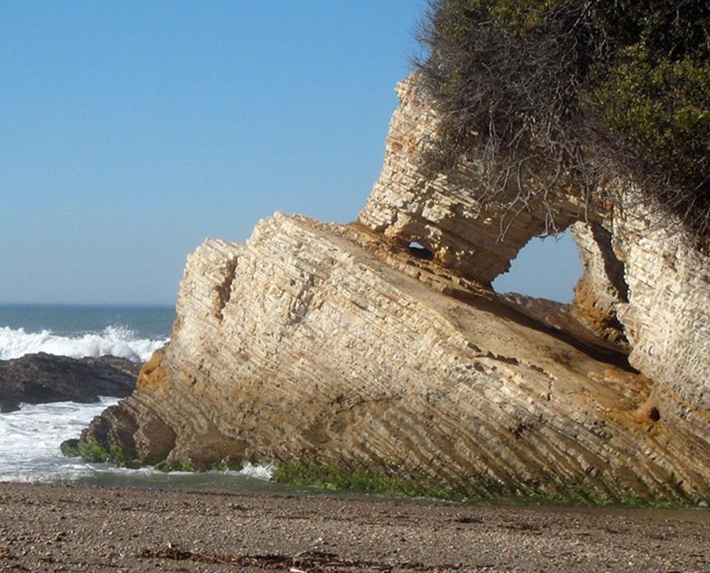
transform boundary Photograph by Robert E. Wallace, USGS.
 transform boundary The San Andreas Fault is undoubtedly the most famous transform boundary in the world. To the west of the fault is the Pacific plate, which is moving northwest. To the east is the North
THE DYNAMIC EARTH NOTES. Scientists divide the Earth into 4 parts or spheres. What are these spheres?
 Hon Environmental Science THE DYNAMIC EARTH NOTES. Scientists divide the Earth into 4 parts or spheres. What are these spheres? 1. geosphere 2. atmosphere 3. hydrosphere 4. biosphere Now, describe each
6.E E Rock Cycle/Weathering/Soil
 Name: Date: 1. A lake is surrounded by hills covered with trees and shrubs. Which statement correctly describes how a change to the plants in this area will affect this environment? A. Adding plants to
Plate Tectonics Tutoiral. Questions. Teacher: Mrs. Zimmerman. Plate Tectonics and Mountains Practice Test
 Teacher: Mrs. Zimmerman Print Close Plate Tectonics and Mountains Practice Test Plate Tectonics Tutoiral URL: http://www.hartrao.ac.za/geodesy/tectonics.html Questions 1. Fossils of organisms that lived
FLOODING. Flood any relatively high stream flow overtopping the natural or artificial banks in a water system.
 CATASTROPHIC EVENTS FLOODING Flood any relatively high stream flow overtopping the natural or artificial banks in a water system. Common Causes: Long-lasting rainfall over a broad area Locally intense
Rocks and the Rock Cycle. Banded Iron Formation
 Rocks and the Rock Cycle Banded Iron Formation Rocks Big rocks into pebbles, Pebbles into sand. I really hold a million, million Rocks here in my hand. Florence Parry Heide How do rocks change? How are
Rocks & Minerals. Lesson 1 Properties of Minerals. What is a mineral? What is a mineral?
 Rocks & Minerals What is a mineral? A mineral must have 5 specific characteristics to be considered a mineral a. b. c. d. e. Naturally occurring - formed by natural processes. Solid - must have a definite