DR-1, DR-2, DR-3, DR-4, DR-5, DR-6
|
|
|
- Penelope Long
- 5 years ago
- Views:
Transcription
1 GSA Data Repository item The influence of large landslides on river incision in a transient landscape: Eastern margin of the Tibetan Plateau (Sichuan, China) William B. Ouimet GSA Bulletin; doi: /B
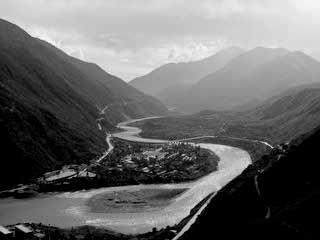
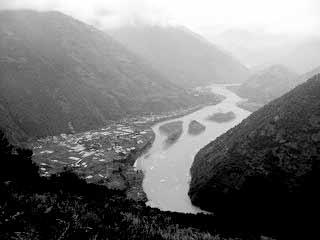
2 GSA Bulletin Data Repository for: The Influence of Large Landslides on River Incision in a Transient Landscape: Eastern Margin of the Tibetan Plateau (Sichuan, China) by William B. Ouimet, Kelin X. Whipple, Leigh H. Royden, Zhiming Sun and Zhiliang Chen Field Photos Additional Case Studies Additional information for Case Studies 1 and 2 (presented in main text) Figures DR-1, DR-2, DR-3, DR-4, DR-5, DR-6 and DR-7 References and Figure Captions FIELD PHOTOS Figures DR-1 and DR-2 contain field photos of large landslide surfaces/deposits, typical landslide rapids associated with active landslide dams, and examples of bedrock and alluvial river channels within river gorges on the eastern margin of the Tibetan plateau. ADDITIONAL CASE STUDIES Field work was focused along the trunk streams and major tributaries of the Dadu and Yalong Rivers, with limited time spent studying the Min River to the east of the Dadu River and the Yangtze River to the west of the Yalong River. Field observations of both active landslide dam sites and inferred sites of landslide dams that existed in the past were prevalent in all rivers gorges studied. Here, we provide additional, illustrative examples from within the Min, Dadu and Yalong river gorges that further highlight the interaction between landslide dams, channel morphology, longitudinal river profiles, and river incision on the eastern margin of the Tibetan plateau. Min River: Deixi Landslides N, E One well-documented, recent example of the powerful influence of landslides is the Deixi slide on the Min River to the east of the Dadu River (Fig. DR-3). It is the best modern analog of an active stable landslide dam on the eastern margin. Three landslide dams formed following a magnitude 7.5 earthquake in 1933 (Costa and Schuster, 1988; Tianchi, 1990). The material that composes the lower two landslide dams was derived from a pre-existing landslide 1
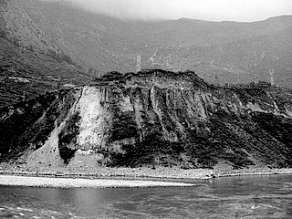
3 deposit an order of magnitude larger in volume than the 1933 landslide masses (Fig. DR-3). This older landslide dammed the Min River ~14,000 years ago, based on the age of lake sediments preserved upstream (Kirby et al., 2002). In the 1933 event, the downstream dam failed catastrophically days after the earthquake, while the upper two did not. These upper two dams continue block the Min River today, having formed large lakes that continue to fill with sediment (Fig. DR-3). The upper most dam, the Yinping landslide blockage, is composed of course rockavalanche deposits and obstructs a relatively narrow bedrock gorge. The top of the Yinping blockage sits 150 m high above the pre-1933 bedrock valley floor, and in the 73 years since the earthquake, the landslide deposits have not incised or eroded significantly. The lake upstream, which was reportedly 10 to 11 km long months after the earthquake, is presently 6 km long with an active delta front of alluvial gravel pro-grading towards the dam (Fig. DR-3ii). Middle Dadu Gorge We define the middle Dadu gorge as the stretch of river between 30.3 to 29.6 north latitude as the Dadu River flows south. This stretch of river is mainly an alluvial reach, with the Dadu meandering through a wide valley m across filled with large alluvial/debris-flow fan material entering from large side tributaries and the deposits and landforms of large landslides (Figs. DR-4 and DR-5). This stretch of river is bounded on its northern and southern ends by distinct bedrock reaches of the Dadu, which have no large landslides within them. The middle Dadu gorge shows no signs of active incision into bedrock; there is no bedrock outcropping within the channel or channel banks, and no strath terraces. The Dadu valley throughout the middle gorge is trying to rework old landslide deposits and reached its bedrock valley floor. The middle Dadu gorge has the largest and most dramatic examples of landslide deposits of anywhere within the Dadu catchment. One particular set of surfaces, called the Luding terraces, record an immense landslide event that crossed and blocked the entire Dadu River valley, and a lake that once existed high above the city of Luding (Figs. DR-5a, 5b, and 5c). South of Luding, distinct landslide masses sit ~700m above the modern river level on both sides of the valley, the eastern of which has a cut-landslide fill terrace half way down. Above Luding, upstream of these landslide deposits, a package of lake sediments ~200m thick sits ~900 m above the present river elevation on top of bedrock. These lake sediments were deposited by the 2
4 Dadu or a side tributary in landslide dammed lake that probably existed more than a million years ago (Chen et al, 2005). The age estimate is based on magneto-stratigraphy work done within the lake sediments, showing at least one magnetic reversal and correlating the sequence to an age of ~4.4 million years (Fuchu et al., 1999). However, because the authors failed to account for significant slumping and deformation within the section, it cannot be confirmed that reversals recorded were not simply one reversal repeating itself within the sequence. In any case, because these deposits sit on bedrock, the Luding terraces demonstrate that landslide damming events occurred when the Dadu trunk level was higher than it is today, and that the relicts of landslide damming events often persist high up on valley walls for thousands or even millions of years. South of Luding, ~20 km, another notable landslide area has a large volume of landslide debris on both sides of the river valley, with the highest landslide surface resting ~450 m above the present river level (see photos, Figs. DR-1c, DR-5d and DR-5g). Incision into the landslide debris has cut large terrace levels within the original landslide deposit. The bottom of these surfaces is landslide material, there is no bedrock, indicating two things: (1) that this landslide complex is younger than the Luding landslide complex, because this complex occurred when the bedrock floor of the middle Dadu gorge was lower than it was at the time of the Luding landslides, and (2) that the Dadu is still reworking the landslide material here and is actively dammed. Age constraints confirm that this landslide complex is young, at least 6,535 +/- 460 years old. This age is from cosmogenic radionuclide ( 10 Be) exposure age dating of a large, ~8 m diameter boulder on top of the landslide deposit. The boulder rests ~200 m above the modern river level, yielding a time-averaged landslide dam erosion rate of ~3.06 +/ mm/yr. The hummocky landslide surface where the sampled boulder rests half buried has been farmed, with possibly up to 2 meters of rock/soil missing. As a result, the age of the landslide should be considered a minimum, making the time-averaged landslide dam erosion rate a maximum. Through the landslide deposits in this area, the Dadu River experiences a significant steepening through the boulder rapids that occur as the river incises into landslide debris. One final landslide example worth noting in the middle Dadu gorge is within a small side tributary of the Dadu north of Luding (Fig. DR-6). This tributary, which enters from the east, is completely back-filled with sediment behind the landslide dam that occurs close to the Dadu. The longitudinal profile of this tributary has a pronounced knickpoint, with characteristic increase in channel steepness through the landslide deposits (Fig. DR-6c). Very different 3
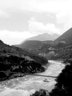
5 interpretations would have been possible for this tributary, such as a fluvial hanging valley, trunk down-cutting and subsequent knickpoint incision migrating upstream, or the outcropping of particularly resistant lithology control. In general, examples where deposits from large landslide dams fill the middle Dadu gorge, there are no significant knickpoints on the longitudinal profile of the Dadu River. Rather, the channel within the middle dadu gorge is steeper than average, suggesting that the integrated effects of incising into landslide deposits has steepened the long-term river profile, but do not cause a distinct knickpoint in the full profile of the Dadu. Dadu Gorge: Confluence of Mar Qu and Do Qu Tributaries The confluence of Mar Qu and Do Qu tributaries of the Dadu occurs within the upper Dadu gorge, west of Barkum (also Ma erkang) in Jinchuan country (Fig. DR-7). Here, another dramatic example of a landslide dam occurs along the main Dadu River profile, where the two main tributaries of the upper Dadu catchment join (the Mar Qu and Do Qu), each dissecting the granite intrusion which encircles their confluence. The main Dadu branch (Mar Qu), which enters this confluence from the east, has a significant landslide dam. In 5 km, the channel drops ~75 m as the river works its way through a landslide package with coarse granite boulders 1-2 m in diameter (Fig. DR-7). Upstream, lake sediments and alluvial fill are preserved and the Dadu River is dammed for ~12 km. The age of the landslide deposit is 56,944 +/- 3,858 years, based on a cosmogenic radionuclide ( 10 Be) exposure age for a large, 5 m diameter boulder on top of the landslide deposit. The boulder we dated rests ~105 m above the modern river level, yielding a time-averaged landslide dam erosion rate of ~1.84 +/ mm/yr. This landslide dam occurs along a stretch of river already over-steepened because of the lithologic contrast between flysch to the North and South and a massive granitic intrusion. Two reaches of boulder rapids occur at large rockfalls upstream on the Mar Qu, and downstream after the confluence, both within the granite. Yalong Gorge Our ability to extensively study the Yalong River gorge in the field has been limited by access. Much of the Yalong gorge lies within a deep, extremely steep gorge without roads. The only significant landslide dam within the Yalong river gorge documented in the field occurs 4
6 1km downstream of the Li Qui/Yalong River confluence (Fig. DR-1e). Here, a dam of unknown age occurs with ~40 m of drop in the rapids, upstream of which the Yalong is dammed for ~10 km. Further downstream, the Yalong river has two large-scale knickpoints on its longitudinal profile (Fig. 2). Although we were not able to visit these sites in the field, analysis of bedrock geology maps and satellite imagery strongly suggests that these knickpoints are landslide related. The hillslope morphology of large landslides is identified, and granite plutons outcrop adjacent to the Yalong gorge, in contrast with reaches to the north and south which lie within predominantly flysch bedrock. It appears as though the combination of large landslides and massive granite boulders in this reach contribute to the large knickpoints seen on the Yalong profile, similar to the lower portion of the Li Qui River. ADDITIONAL INFORMATION FOR CASE STUDIES PRESENTED IN MAIN TEXT Case Study 1: Dadu Gorge and Tributaries - Danba Region As exemplified by the Ge Sud Za example (Fig. 5), rivers around Danba appear strongly influenced by large landslides and are detached from their bedrock valley floors, with no indication of quick incision into landslide-related deposits, or, a return to steady incision into bedrock. North of Danba, the western valley wall consists of a large complex of landslides. This area has many landslide scarps, indicating continual reactivation of the landslide debris. The most recent reactivation has produced a large landslide dam on the Dadu (Fig. 4, photo DR-1g). The dam is ~9 km upstream from the town of Danba, and has ~80 m of drop in the rapids caused by the landslide deposits. This is largest direct drop on the Dadu mainstem associated with a single, active landslide dam. Upstream of the dam, the channel meanders through a valley filled with alluvial gravel for ~10 km. Farther north of this landslide dam (~28 km upstream of Danba), the Dadu dissects a granitic pluton which outcrops to the NW and SE of the river. The general steepening seen in the Dadu profile within this granite section is associated with two large landslide complexes and debris flow fans which enter from side tributaries (Fig. 4). Within the 90 km of river channel upstream of this granite section, the Dadu mainstem contains no active landslide dams and is gentle and alluvial, suggesting that it is hung up and dammed behind the landslide complexes associated with this granitic body. The Xiaojin Chaun tributary has two significant landslide dams, the biggest of which is ~17 km upstream from the confluence with the Dadu with ~100 m of drop in the rapids caused 5
7 by the landslide deposits (Fig. 4). The landslide occurred on the SE of the valley and landslide debris has pinned the channel against the NW bedrock valley wall. Rapids through this landslide dam are now caused by large landslide boulders and the abraded, sculpted bedrock wall. Upstream, the valley is filled for ~17 km, but side tributaries have not yet built large alluvial fans upon the fill level, suggesting that it is considerably younger than the biggest example on the Ge Sud Za He (i.e., << 9000 yrs old). Finally, the Dong Gu He tributary has one significant landslide dam, with ~60 m of drop in the rapids caused by the landslide deposits, which consist of large, 5-10 m boulders. This dam on the Dong Gu He tributary occurs at a drainage area much less than the examples on the Xiaojin Chaun and Ge Sud Ze He tributaries, and as a result, the channel gradient is much steeper and the upstream filling behind the dam does not extentd more than 2-3 km. Case Study 2: Li Qui River The Li Qui example emphasizes the influence of local sediment flux from hillslopes on controlling river gradients, and stresses the role of grain size and lithology. Steep river gradients will persist wherever the adjacent hillslope lithology is massive enough to deliver coarse boulders to the channel, regardless of the hillslope erosion process responsible for their deposition (debris flow, rockfall, large landslide, etc.). For most of its length, the Li Qui cuts flysch, but three granite intrusions lie along the profile (Fig. 6b). The river dissects the upper and middle granite intrusions, and lies just to the south of the lower granite intrusion. The upper granite intrusion defines a sharp knickpoint on the longitudinal profile of the Li Qui, with bedrock occasionally outcropping in the channel (profile location A in Fig. 6c). The channel itself is a continuous boulder cascade composed primarily of 1 to 3 m granite boulders. The processes delivering these boulders to the channel are most likely periglacial weathering of bedrock outcrops on adjacent hillslopes, small rockfalls, and other mass wasting processes. In contrast, the middle granite intrusion does not have a morphologic expression in the longitudinal profile (profile location B in Fig. 6c). The channel here contains less than 1% granite boulders, and the Li Qui river valley is wide and alluviated, suggesting the possibility that a knickpoint on the bedrock valley floor is buried beneath the fill. The lower granite intrusion coincides with the dramatic steepening of the profile as it falls to join the Yalong (profile location C in Fig. 6c). Here, massive granite does not outcrop directly in the channel or adjacent hillslopes, but it does 6
8 outcrop high up on the valley walls. The large boulders seen in the channel armoring the bed are granite, presumably delivered to the channel from rockfalls and landslides. Figure 6d shows that well-preserved lake and alluvial fill gravels record a period of prolonged river damming on the Li Qui and the river has subsequently incised into a portion these sediments. The highest fill level increases in height moving downstream and wide-spread landslide deposits indicate the likely site of an ancestral landslide dam. This is also where all outcrops of incised sediments end. Within the 50 km of incised sediment behind the ancestral landslide dam site (Fig. 6d), we have dated lake sediments in three locations and the alluvial gravels in two locations. The lake sediment dates are Optically Stimulated Luminescence (OSL) ages from quartz grains, intended to constrain the time when these fine sediments were deposited in a lake environment. The three ages are 4,214 +/- 605, 5,030 +/- 950, and 7,780 +/- 1,200 years old. The two alluvial gravel ages are from cosmogenic radionuclide ( 10 Be) depth profiles, intended to constrain the time the timing of abandonment of fill terraces. We interpret these fill terraces to represent the active river level at the time the Li Qui River was adjusted (or graded) to a base-level fixed at the top of a landslide dam downstream. We sampled this paleo-li Qui River level in two places: upstream where the fill terrace level is ~17 m above the modern river level, and downstream where the fill terrace level is ~60 m above the modern river level. The upstream age is 7,935 +/- 785 years old and the downstream age is /- 215 years old. Depending on what we assume about the post-depositional history of the fill terraces, the timing of abandonment in relation to one another, or the inherent uncertainty of dating lake sediments with OSL, we can use these ages to say that these sediments were deposited behind one landslide dam sometime between 4000 and 8000 years ago (deposited over a period of ~1000 years), or two landslides dams, one ~5000 years ago and the other ~8000 yrs ago. Either way, since the river is still reworking and incising into these sediments and has not reached the bedrock valley floor, they indicate that landslides have dominated this stretch of river for at least the last ~8000 years, and perhaps much longer. ACKNOWLEDGEMENTS Work supported by the NSF Continental Dynamics program (EAR ), in collaboration with the Chengdu Institute of Geology and Mineral Resources. Thanks to Joel Johnson, Jamon Frostenson, Tang Fawei, and Miu Guoxia for assistance in the field; Shannon Mahon for help 7
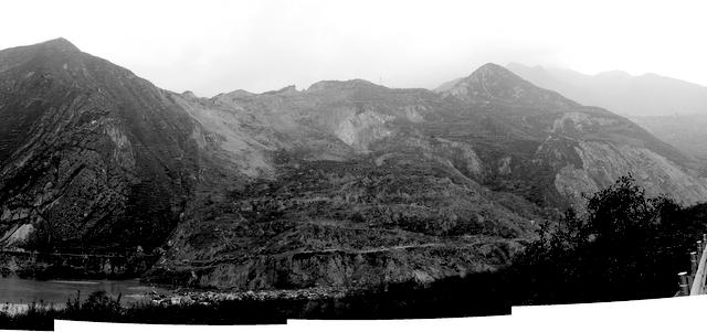
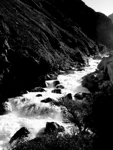
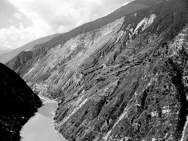
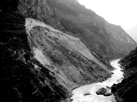
9 with preliminary OSL dates; and Darryl Granger, Tom Clifton, Andy Cyr, Marc Caffee and the Purdue PRIME Lab staff for help with cosmogenic analysis. REFERENCES: Chen, Z., Sun, Z., Royden, L., and Zhang, X., 2004, Landslide Blocked Lake: Origin of the Xigeda Formation in Luding, Sichuan and its Significance, Chinese Academy of Geology, Beijing, China (in Chinese). Costa, J.E., and Schuster, R.L., 1988, The formation and failure of natural dams, Geological Society of America Bulletin, v. 100, p Fuchu, J., Xihao, W. and Huaguo, X., 1999, Luding Xigeda Epoch and Lifting of the Western Sichuan Plateau, Chinese Academy of Geology, Beijing, China (in Chinese). Kirby, E., Burchfiel, B.C., Whipple, K.X., Tang, W., Berger, G., Sun, Z., and Chen, Z., 2000, Neotectonics of the Min Shan, China: Implications for mechanisms driving Quaternary deformation along the eastern margin of the Tibetan Plateau, GSA Bulletin, v. 112, pp Tianchi, L., 1990, Landslide management in the mountain areas of China: ICIMOD Occasional Paper No. 15, Kathmandu, Nepal. FIGURE CAPTIONS: Figure DR-1: Field photos of large landslide surfaces/deposits and steep, narrow boulder rapids through landslides deposits: (a) Dadu River, north of Danba; (b) Min River, west of Maowen; (c) Dadu River, south of Luding; (d) Dadu River, north of Jinchuan; (e) Yalong River, south of Li Qui confluence; (f) Li Qui River, ~3 km from its confluence with the Yalong River; (g) Dadu River, north of Danba. Figure DR-2: Field photos of bedrock and alluvial river channels within the Yalong and Dadu River catchments, showing the highly variable nature of channel and valley widths. (a) Alluvial reach, Dadu River, south of Jinchuan; (b) Alluvial reach, Dadu River, 100 km downstream of Luding; (c) Alluvial reach, Dadu River, Luding area; (d) Bedrock reach, Yalong River, north of Yajiang. (e) Bedrock reach and landslide rapids, Dadu River, north of Danba; (f) Bedrock reach, Dadu River, north of Luding; (g) Bedrock reach, Yalong River, south of Yajiang. 8
10 Figure DR-3: Deixi Landslides on the Min River (32.05 N, E). (a) River profile through the landslide dams. Coarsely dashed box denotes the older, ~14,000 year old landslide deposits; smaller, more finely dashed boxes denote the landslide deposits which dammed the Min River in (b) Map of the Deixi area with 1933 landslide scars (bold black lines with teeth) and landslide dam (gray shading) indicated. Landslide scars associated with the older, ~14,000 year old landslide deposits noted as gray lines with teeth. Note locations of photos (i), (ii) and (iii). (i) Photo of the upper landslide dam: the Yinping blockage. (ii) Photo of the active delta front of alluvial gravel pro-grading into the lake. (iii) Photo of the older, ~14,000 year old landslide deposits. Figure DR-4: Map of the middle Dadu gorge between 30.3 to 29.6 N as the Dadu River flows south. Landslide scars (bold black lines with teeth), and inferred landslide dams (gray shading) indicated. Dashed gray line indicates the Luding terrace composed of lake sediments 900 m above the present Dadu level. Markers (a) through (g) denote the locations of field photos in Figure DR-5. Figure DR-5: Field photos from the middle Dadu gorge region. (a), (b) Luding terraces, landslide deposits downstream of Luding; (c) Luding terrace, lake sediments above Luding; (d), (g) Landslide complex 20 km south of Luding; (e) Landslide scar and surface, south of Luding; (f) Landslide deposits, north of Luding. Figure DR-6: North of Luding, small tributary of Dadu completely filled behind landslide dam. (a) ASTER satellite image, resolution 15 m, visible bands 1, 2 and 3. Area filled with white bars indicates the extent of landslide deposits and associated dam. Dashed line outlines the extent of filled valley upstream of landslide dam. (b) Longitudinal river profile extracted from 30 m DEM derived from the ASTER imagery. (c) Slope-Area data for the profile. Note the large knickpoint and extremely high channel steepness values through the landslide deposit. Figure DR-7: (a) Map of the confluence of Mar Qu and Do Qu Tributaries ( N, E). Landslide scar (bold black lines with teeth) and landslide dam (gray shading) 9
11 indicated. Note locations of photos (i) and (ii). White star marks the location of the landslide boulder we dated to 56,944 +/- 3,858 years old. (b) River profile through the landslide dam. 10


12 Ouimet et al., Figure DR-1 a b c d e g f


13 Ouimet et al., Figure DR-2 a b d c e f g
")


14 Tributary Ouimet et al., Figure DR (a) Elevation (m) Distance (km) (b) Min R. i ii i ii iii N Min R. 4 km iii
15 Ouimet et al., Figure DR ' E 1500 m Dadu He 10 km 30 10' N N 30 10' N 30 0' N Wa Si He Fig. DR-5 Dadu He 29 50' N 30 0' N f Luding c a 29 40' N 29 50' N b e Moxi Gou He Dadu He d 29 40' N g 1100 m ' E


16 Ouimet et al., Figure DR-5 a b c d e g f
 3 km (c) 10 0 slope 10-1 10-2 10-3 10 5 10 6 10 7 drainage area (m 2 10 8 ) (b) 3000")
17 Ouimet et al., Figure DR-6 (a) 3 km (c) 10 0 slope drainage area (m ) (b) 3000 Elevation (m) Landslide Deposits Distance from Dadu Trunk (km) 2 0
 4 km N 2380 m i Mar Q u")
 2400 2300 2200 2100 0 5 10")
18 Ouimet et al., Figure DR-7 (a) 4 km N 2380 m i Mar Q u (Dadu) ii Do Qu Dadu He 2220 m 2500 (b) Elevation (m) Distance (km) i ii
The influence of large landslides on river incision in a transient landscape: Eastern margin of the Tibetan Plateau (Sichuan, China)
") The influence of large landslides on river incision in a transient landscape: Eastern margin of the Tibetan Plateau (Sichuan, China) William. Ouimet Department of Earth, tmospheric, and Planetary Sciences,
The influence of large landslides on river incision in a transient landscape: Eastern margin of the Tibetan Plateau (Sichuan, China) William. Ouimet Department of Earth, tmospheric, and Planetary Sciences,
mountain rivers fixed channel boundaries (bedrock banks and bed) high transport capacity low storage input output
 high transport capacity low storage input output") mountain rivers fixed channel boundaries (bedrock banks and bed) high transport capacity low storage input output strong interaction between streams & hillslopes Sediment Budgets for Mountain Rivers Little
mountain rivers fixed channel boundaries (bedrock banks and bed) high transport capacity low storage input output strong interaction between streams & hillslopes Sediment Budgets for Mountain Rivers Little
Epigenetic gorges in fluvial landscapes
 Earth Surface Processes and Landforms Epigenetic Earth Surf. Process. gorges Landforms in fluvial landscapes (2008) 1 Published online in Wiley InterScience (www.interscience.wiley.com).1650 Epigenetic
Erosion Surface Water. moving, transporting, and depositing sediment.
 + Erosion Surface Water moving, transporting, and depositing sediment. + Surface Water 2 Water from rainfall can hit Earth s surface and do a number of things: Slowly soak into the ground: Infiltration
Landscape Development
 Landscape Development Slopes Dominate Natural Landscapes Created by the interplay of tectonic and igneous activity and gradation Deformation and uplift Volcanic activity Agents of gradation Mass wasting
The Effects of Hydraulic Structures on Streams Prone to Bank Erosion in an Intense Flood Event: A Case Study from Eastern Hokkaido
 Symposium Proceedings of the INTERPRAENENT 2018 in the Pacific Rim The Effects of Hydraulic Structures on Streams Prone to Bank Erosion in an Intense Flood Event: A Case Study from Eastern Hokkaido Daisuke
The Geology of Sebago Lake State Park
 Maine Geologic Facts and Localities September, 2002 43 55 17.46 N, 70 34 13.07 W Text by Robert Johnston, Department of Agriculture, Conservation & Forestry 1 Map by Robert Johnston Introduction Sebago
UNRAVELING THE HISTORY OF A LANDSCAPE: Using geomorphology, tephrochronology, and stratigraphy. Photo by: Josh Roering
 UNRAVELING THE HISTORY OF A LANDSCAPE: Using geomorphology, tephrochronology, and stratigraphy Photo by: Josh Roering Photo: Eric Bilderback Photo by: Josh Roering Goal 1. Reconstruct the paleo-landscape
Preservation or Piracy: Diagnosing low relief, high elevation surface formation mechanisms. Supplemental Methods: Additional methodological details.
 GSA Data Repository 2017023 Preservation or Piracy: Diagnosing low relief, high elevation surface formation mechanisms Kelin X. Whipple 1, Roman A. DiBiase 2, William B. Ouimet 3, Adam M. Forte 1 Contents
Down-stream process transition (f (q s ) = 1)
 = 1)") Down-stream process transition (f (q s ) = 1) Detachment Limited S d >> S t Transport Limited Channel Gradient (m/m) 10-1 Stochastic Variation { Detachment Limited Equilibrium Slope S d = k sd A -θ d S
Down-stream process transition (f (q s ) = 1) Detachment Limited S d >> S t Transport Limited Channel Gradient (m/m) 10-1 Stochastic Variation { Detachment Limited Equilibrium Slope S d = k sd A -θ d S
4. The map below shows a meandering stream. Points A, B, C, and D represent locations along the stream bottom.
 1. Sediment is deposited as a river enters a lake because the A) velocity of the river decreases B) force of gravity decreases C) volume of water increases D) slope of the river increases 2. Which diagram
SUPPLEMENTAL MATERIAL
 SUPPLEMENTAL MATERIAL DESCRIPTIONS OF OTHER STRATIGRAPHIC SECTIONS Cherry Creek In its middle reaches, Cherry Creek meanders between three paired terraces within a narrow bedrock valley. The highest is
Step 5: Channel Bed and Planform Changes
 Step 5: Channel Bed and Planform Changes When disturbed, streams go through a series of adjustments to regain equilibrium with the flow and sediment supply of their watersheds. These adjustments often
Summary. Streams and Drainage Systems
 Streams and Drainage Systems Summary Streams are part of the hydrologic cycle and the chief means by which water returns from the land to the sea. They help shape the Earth s surface and transport sediment
11/12/2014. Running Water. Introduction. Water on Earth. The Hydrologic Cycle. Fluid Flow
 Introduction Mercury, Venus, Earth and Mars share a similar history, but Earth is the only terrestrial planet with abundant water! Mercury is too small and hot Venus has a runaway green house effect so
GEOL 1121 Earth Processes and Environments
 GEOL 1121 Earth Processes and Environments Wondwosen Seyoum Department of Geology University of Georgia e-mail: seyoum@uga.edu G/G Bldg., Rm. No. 122 Seyoum, 2015 Chapter 6 Streams and Flooding Seyoum,
Mountain Rivers. Gutta cavat lapidem. (Dripping water hollows out a stone) -Ovid, Epistulae Ex Ponto, Book 3, no. 10, 1. 5
 -Ovid, Epistulae Ex Ponto, Book 3, no. 10, 1. 5") Mountain Rivers Gutta cavat lapidem (Dripping water hollows out a stone) -Ovid, Epistulae Ex Ponto, Book 3, no. 10, 1. 5 Mountain Rivers Fixed channel boundaries (bedrock banks and bed) High transport
Mountain Rivers Gutta cavat lapidem (Dripping water hollows out a stone) -Ovid, Epistulae Ex Ponto, Book 3, no. 10, 1. 5 Mountain Rivers Fixed channel boundaries (bedrock banks and bed) High transport
Vermont Stream Geomorphic Assessment. Appendix E. River Corridor Delineation Process. VT Agency of Natural Resources. April, E0 - April, 2004
 Vermont Stream Geomorphic Assessment Appendix E River Corridor Delineation Process Vermont Agency of Natural Resources - E0 - River Corridor Delineation Process Purpose A stream and river corridor delineation
DETAILED DESCRIPTION OF STREAM CONDITIONS AND HABITAT TYPES IN REACH 4, REACH 5 AND REACH 6.
 DETAILED DESCRIPTION OF STREAM CONDITIONS AND HABITAT TYPES IN REACH 4, REACH 5 AND REACH 6. The Eklutna River was divided into study reaches (figure 1) prior to this site visit. Prominent geologic or
Topographic metrics and bedrock channels Outline of this lecture
 Topographic metrics and bedrock channels Outline of this lecture Topographic metrics Fluvial scaling and slope-area relationships Channel steepness sensitivity to rock uplift Advancing understanding of
GLG598 Surface Processes and Landform Evolution K. Whipple Fall 2012 VERDE RIVER: FLOW MECHANICS, ROUGHNESS, AND SHEAR STRESS
 VERDE RIVER: FLOW MECHANICS, ROUGHNESS, AND SHEAR STRESS This lab will introduce you to some common field techniques and some general understanding of the geomorphic processes operating in a stream. The
Streams. Stream Water Flow
 CHAPTER 14 OUTLINE Streams: Transport to the Oceans Does not contain complete lecture notes. To be used to help organize lecture notes and home/test studies. Streams Streams are the major geological agents
Cattaraugus Creek: A Story of Flowing Water and the Geology of the Channel It Flows Through Presentation to West Valley Citizen Task Force 4/27/16
 Cattaraugus Creek: A Story of Flowing Water and the Geology of the Channel It Flows Through Presentation to West Valley Citizen Task Force 4/27/16 Raymond C. Vaughan, Ph.D. What happens if you drop a
A Geological Tour of Tumbledown Mountain, Maine
 Maine Geologic Facts and Localities April, 1998 A Geological Tour of Tumbledown Mountain, Maine 44 45 3.21 N, 70 32 50.24 W Text by Robert G. Marvinney, Department of Agriculture, Conservation & Forestry
Earth Science Chapter 6 Section 2 Review
 Name: Class: Date: Earth Science Chapter 6 Section Review Multiple Choice Identify the choice that best completes the statement or answers the question. 1. Most streams carry the largest part of their
Paradoxes of Fluvial Evolution in Young Orogenic Systems
 Journal of Indian Geomorphology Volume 5, 2017 ISSN 2320-0731 Indian Institute of Geomorphologists (IGI) Paradoxes of Fluvial Evolution in Young Orogenic Systems Leszek Starkel Department of Geoenvironmental
PHYSICAL GEOGRAPHY. By Brett Lucas
 PHYSICAL GEOGRAPHY By Brett Lucas FLUVIAL PROCESSES Fluvial Processes The Impact of Fluvial Processes on the Landscape Streams and Stream Systems Stream Channels Structural Relationships The Shaping and
Stream Classification
 Stream Classification Why Classify Streams? Communication Tool Describe Existing Conditions & Trends Describe Restoration Goals Research Tool Morphologic Stream Classification Systems Schumm (1977) Alluvial
Streams. Water. Hydrologic Cycle. Geol 104: Streams
 Streams Why study streams? Running water is the most important geologic agent in erosion, transportation and deposition of sediments. Water The unique physical and chemical properties of water make it
1. Base your answer to the following question on the map below, which shows the generalized bedrock of a part of western New York State.
 1. Base your answer to the following question on the map below, which shows the generalized bedrock of a part of western New York State. 3. The table below describes the deposits that an observer saw while
Ch 10 Deposition Practice Questions
 1. Base your answer to the following question on the data table below. Six identical cylinders, A through F, were filled with equal volumes of sorted spherical particles. The data table shows the particle
Dams, sediment, and channel changes and why you should care
 Dams, sediment, and channel changes and why you should care Gordon E. Grant USDA Forest Service PNW Research Station Corvallis, Oregon Dam effects on river regimes FLOW (Q) SEDIMENT (Qs) TEMP CHEMISTRY
FLUVIAL LANDFORMS. Floodplains
 FLUVIAL LANDFORMS Floodplains fairly flat & continuous surface occupying much of a valley bottom normally underlain by unconsolidated sediments subject to periodic flooding (usually once every year or
Determination of uplift rates of fluvial terraces across the Siwaliks Hills, Himalayas of central Nepal
 Determination of uplift rates of fluvial terraces across the Siwaliks Hills, Himalayas of central Nepal Martina Böhme Institute of Geology, University of Mining and Technology, Freiberg, Germany Abstract.
SECTION G SEDIMENT BUDGET
 SECTION G SEDIMENT BUDGET INTRODUCTION A sediment budget has been constructed for the for the time period 1952-2000. The purpose of the sediment budget is to determine the relative importance of different
Name: Mid-Year Review #2 SAR
 Name: Mid-Year Review #2 SAR Base your answers to questions 1 through 3 on on the diagram below, which shows laboratory materials used for an investigation of the effects of sediment size on permeability,
GEOMORPHIC CHANGES OF A LANDSLIDE DAM BY OVERTOPPING EROSION
 DOI: 10.4408/IJEGE.2011-03.B-087 GEOMORPHIC CHANGES OF A LANDSLIDE DAM BY OVERTOPPING EROSION K. Yoshino (*), T. Uchida (*), T. shimizu (*) & K. Tamura (*) (*) Incorporated Administrative Agency, Public
LANDFORM REGIONS IN CANADA. Classroom Notes and Descriptions
 LANDFORM REGIONS IN CANADA Classroom Notes and Descriptions Landform Regions in Canada There are eight distinct landforms in Canada: Western Cordillera Region Interior Plains Canadian Shield Hudson Bay
Waterbury Dam Disturbance Mike Fitzgerald Devin Rowland
 Waterbury Dam Disturbance Mike Fitzgerald Devin Rowland Abstract The Waterbury Dam was completed in October 1938 as a method of flood control in the Winooski Valley. The construction began in April1935
Running Water Earth - Chapter 16 Stan Hatfield Southwestern Illinois College
 Running Water Earth - Chapter 16 Stan Hatfield Southwestern Illinois College Hydrologic Cycle The hydrologic cycle is a summary of the circulation of Earth s water supply. Processes involved in the hydrologic
FUTURE MEANDER BEND MIGRATION AND FLOODPLAIN DEVELOPMENT PATTERNS NEAR RIVER MILES 241 TO 235, SACRAMENTO RIVER
 FUTURE MEANDER BEND MIGRATION AND FLOODPLAIN DEVELOPMENT PATTERNS NEAR RIVER MILES 241 TO 235, SACRAMENTO RIVER Eric W. Larsen University of California, Davis With the assistance of Evan Girvetz REPORT
Chapter 2. Wearing Down Landforms: Rivers and Ice. Physical Weathering
 Chapter 2 Wearing Down Landforms: Rivers and Ice Physical Weathering Weathering vs. Erosion Weathering is the breakdown of rock and minerals. Erosion is a two fold process that starts with 1) breakdown
1. Erosion by Running Water Most powerful cause of erosion
 I. Destructive Forces Notes: Destructive force: a process in which land is destroyed or changed such as weathering and erosion. All landforms are a result of a combination of constructive and destructive
Topic 6: Weathering, Erosion and Erosional-Deposition Systems (workbook p ) Workbook Chapter 4, 5 WEATHERING
 Workbook Chapter 4, 5 WEATHERING") Topic 6: Weathering, Erosion and Erosional-Deposition Systems (workbook p. 95-125) Workbook Chapter 4, 5 THE BIG PICTURE: Weathering, erosion and deposition are processes that cause changes to rock material
Topic 6: Weathering, Erosion and Erosional-Deposition Systems (workbook p. 95-125) Workbook Chapter 4, 5 THE BIG PICTURE: Weathering, erosion and deposition are processes that cause changes to rock material
Lab Final Review 4/16/18
 Lab Final Review 4/16/18 Overall goals from lab Think about geology on recent timescales, predict the direction change Be able to identify how different landforms or patterns (e.g. drainage patterns, dune
Distribution of active rock uplift along the eastern margin of the Tibetan Plateau: Inferences from bedrock channel longitudinal profiles
 JOURNAL OF GEOPHYSICAL RESEARCH, VOL. 108, NO. B4, 2217, doi:10.1029/2001jb000861, 2003 Distribution of active rock uplift along the eastern margin of the Tibetan Plateau: Inferences from bedrock channel
Appendix E Rosgen Classification
 Appendix E Stream Type s Using the morphometric parameters described above, stream reaches are classified into 7 major stream types (Aa+ through G) based on s (1996) criteria. The relevant stream classifications
STUDY GUIDE FOR CONTENT MASTERY. Surface Water Movement
 Surface Water SECTION 9.1 Surface Water Movement In your textbook, read about surface water and the way in which it moves sediment. Complete each statement. 1. An excessive amount of water flowing downslope
A floodplain is the flat land immediately surrounding a stream channel and innundated at 5mes of high flow.
 A floodplain is the flat land immediately surrounding a stream channel and innundated at 5mes of high flow. Aggrada5on occurs when deposi5on is greater than erosion. Aggrada&on of the Rivière des Ha! Ha!
Laboratory Exercise #4 Geologic Surface Processes in Dry Lands
 Page - 1 Laboratory Exercise #4 Geologic Surface Processes in Dry Lands Section A Overview of Lands with Dry Climates The definition of a dry climate is tied to an understanding of the hydrologic cycle
Surface Water and Stream Development
 Surface Water and Stream Development Surface Water The moment a raindrop falls to earth it begins its return to the sea. Once water reaches Earth s surface it may evaporate back into the atmosphere, soak
Infilled Kettle Hole, Easton, Aroostook County, Maine
 Maine Geologic Facts and Localities June, 1997, Maine 46 41 26.40 N, 67 48 35.74 W Text by Tom Weddle, Department of Agriculture, Conservation & Forestry 1 Introduction As the last continental glacier
Natural hazards in Glenorchy Summary Report May 2010
 Natural hazards in Glenorchy Summary Report May 2010 Contents Glenorchy s hazardscape Environment setting Flood hazard Earthquakes and seismic hazards Hazards Mass movement Summary Glossary Introduction
GLG598 Surface Processes and Landform Evolution K. Whipple VERDE RIVER: FLOW MECHANICS, ROUGHNESS, AND SHEAR STRESS
 VERDE RIVER: FLOW MECHANICS, ROUGHNESS, AND SHEAR STRESS This lab will introduce you to some common field techniques and some general understanding of the geomorphic processes operating in a stream. The
PHASE 1 STUDIES UPDATE EROSION WORKING GROUP
 PHASE 1 STUDIES UPDATE EROSION WORKING GROUP Presented By MICHAEL WOLFF, PG Erosion Study Area Manager West Valley Demonstration Project Quarterly Public Meeting February 24, 2016 OUTLINE Study 1 Terrain
Stratigraphic modelling using CHILD
 5 Stratigraphic modelling using CHILD 5.1 Triangular irregular network Surface process models are widely used in geomorphology and geology, and the developments in the field follow each other rapidly.
Amplification of bedrock canyon incision by wind
 SUPPLEMENTARY INFORMATION DOI: 10.1038/NGEO2381 Amplification of bedrock canyon incision by wind Jonathan P. Perkins, Noah J. Finnegan, Shanaka L. de Silva NATURE GEOSCIENCE www.nature.com/naturegeoscience
Pratice Surface Processes Test
 1. The cross section below shows the movement of wind-driven sand particles that strike a partly exposed basalt cobble located at the surface of a windy desert. Which cross section best represents the
Prentice Hall EARTH SCIENCE
 Prentice Hall EARTH SCIENCE Tarbuck Lutgens Chapter 7 Glaciers, Desert, and Wind 7.1 Glaciers Types of Glaciers A glacier is a thick ice mass that forms above the snowline over hundreds or thousands of
ES 105 Surface Processes I. Hydrologic cycle A. Distribution % in oceans 2. >3% surface water a. +99% surface water in glaciers b.
 ES 105 Surface Processes I. Hydrologic cycle A. Distribution 1. +97% in oceans 2. >3% surface water a. +99% surface water in glaciers b. >1/3% liquid, fresh water in streams and lakes~1/10,000 of water
Rivers T. Perron
 1 Rivers T. Perron 12.001 After our discussions of large-scale topography, how we represent topography in maps, and how topography interacts with geologic structures, you should be frothing at the mouth
depression above scarp scarp
 1 LAB 1: FIELD TRIP TO McKINLEYVILLE AND MOUTH OF THE MAD RIVER OBJECTIVES: a. to look at geomorphic and geologic evidence for large scale thrust-faulting of young sediments in the Humboldt Bay region
Annotated Bibliography of River Avulsions Pat Dryer Geography 364 5/14/2007
 Annotated Bibliography of River Avulsions Pat Dryer Geography 364 5/14/2007 1 Table of Contents Introduction 2 Annotations I. River avulsions and their deposits 2 II. Channel avulsion on alluvial fans
Weathering, Erosion, Deposition, and Landscape Development
 Weathering, Erosion, Deposition, and Landscape Development I. Weathering - the breakdown of rocks into smaller particles, also called sediments, by natural processes. Weathering is further divided into
Supplementary Material
 GSA Data Repository item 2018118 Brardinoni, F., Picotti, V., Maraio, S., Paolo Bruno, P., Cucato, M., Morelli, C., and Mair, V., 2018, Postglacial evolution of a formerly glaciated valley: Reconstructing
Notes and Summary pages:
 Topographic Mapping 8.9C Interpret topographical maps and satellite views to identify land and erosional features and predict how these shapes may be reshaped by weathering ATL Skills: Communication taking
Pengcheng Su (*,**,***), Fangqian Wei (**,***), Zunlan Cheng (**,***) & Jingjing Liu (*,**,***)
, Fangqian Wei (**,***), Zunlan Cheng (**,***) & Jingjing Liu (*,**,***)") DOI: 10.4408/IJEGE.2011-03.B-084 Debris flows in Mozi gully, China following the 2008 Wenchuan earthquake Pengcheng Su (*,**,***), Fangqian Wei (**,***), Zunlan Cheng (**,***) & Jingjing Liu (*,**,***)
DOI: 10.4408/IJEGE.2011-03.B-084 Debris flows in Mozi gully, China following the 2008 Wenchuan earthquake Pengcheng Su (*,**,***), Fangqian Wei (**,***), Zunlan Cheng (**,***) & Jingjing Liu (*,**,***)
Four Mile Run Levee Corridor Stream Restoration
 Four Mile Run Levee Corridor Stream Restoration 30% Design Summary U.S. Army Corps of Engineers, Baltimore District Presentation Outline Four Mile Run 1.) Historic Perspective 2.) Existing Conditions 3.)
Page 1. Name:
 Name: 1) Which property would best distinguish sediment deposited by a river from sediment deposited by a glacier? thickness of sediment layers age of fossils found in the sediment mineral composition
Continental Landscapes
 Continental Landscapes Landscape influenced by tectonics, climate & differential weathering Most landforms developed within the last 2 million years System moves toward an equilibrium Continental Landscapes
Conceptual Model of Stream Flow Processes for the Russian River Watershed. Chris Farrar
 Conceptual Model of Stream Flow Processes for the Russian River Watershed Chris Farrar Several features of creeks affect the interactions between surface and groundwater. This conceptual model uses the
Page 1. Name:
 Name: 1) Which event is the best example of erosion? dissolving of rock particles on a limestone gravestone by acid rain breaking apart of shale as a result of water freezing in a crack rolling of a pebble
EROSION AND DEPOSITION
 CHAPTER 8 EROSION AND DEPOSITION SECTION 8 1 Changing Earth s Surface (pages 252-255) This section explains how sediment is carried away and deposited elsewhere to wear down and build up Earth s surface.
Erosional Features. What processes shaped this landscape?
 Have you ever looked at the land around you and wondered what processes shaped what you see? Perhaps you see mountains, valleys, rivers, or canyons. Do you know how long these geologic features have been
Year 6. Geography. Revision
 Year 6 Geography Revision November 2017 Rivers and World knowledge How the water cycle works and the meaning of the terms evaporation, condensation, precipitation, transpiration, surface run-off, groundwater
Clyde River Landslide
 Clyde River Landslide Department of Geology, Perkins Hall, University of Vermont, Burlington, VT 05405 Abstract: This paper investigates a landslide on the Clyde River in Newport, Vermont. The landslide
Chapter 12: River Systems and Landforms
 Chapter 12: River Systems and Landforms Base Levels: Local and Ultimate Figure 12.6 Figure 12.2 A Drainage Basin Rills and Gullies feeding into small Streams in Iowa North American Drainage Basins Figure
Why Geomorphology for Fish Passage
 Channel Morphology - Stream Crossing Interactions An Overview Michael Love Michael Love & Associates mlove@h2odesigns.com (707) 476-8938 Why Geomorphology for Fish Passage 1. Understand the Scale of the
EROSIONAL FEATURES. reflect
 reflect Have you ever looked at the land around you and wondered what processes shaped what you see? Perhaps you see mountains, valleys, rivers, or canyons. Do you know how long these geologic features
Geomorphic Importance of Winter Peak Flows and Annual Snowmelt Hydrographs in a Sierra Nevada Boulder-Bedrock River
 Geomorphic Importance of Winter Peak Flows and Annual Snowmelt Hydrographs in a Sierra Nevada Boulder-Bedrock River Scott McBain and Bill Trush McBain & Trush, Inc. Clavey River and Cherry Creek vicinity
Rivers. Regents Earth Science Weathering & Erosion
 Regents Earth Science Weathering & Erosion Name: Rivers Use your notes, the handout Weathering and Erosion and your review book to answer the following questions on Rivers. Be sure to read the information
What is weathering and how does it change Earth s surface? Answer the question using
 7 th Grade Lesson What is weathering and how does it change Earth s surface? Answer the question using the sentence frame. You have 4 minutes. Weathering is. This changes the Earth s surface because. 1
Essential Questions. What is erosion? What is mass wasting?
 Erosion Essential Questions What is erosion? What is mass wasting? What is Erosion? Erosion The transportation of sediment from one area to another Caused mainly by running water but also caused by glaciers,
1. Any process that causes rock to crack or break into pieces is called physical weathering. Initial product = final product
 Weathering 1. Any process that causes rock to crack or break into pieces is called physical weathering. Initial product = final product End Result of physical weathering is increased surface area. 2. Physical
3.12 Geology and Topography Affected Environment
 3 Affected Environment and Environmental Consequences 3.12 Geology and Topography 3.12.1 Affected Environment 3.12.1.1 Earthquakes Sterling Highway MP 45 60 Project Draft SEIS The Kenai Peninsula is predisposed
GLG362/GLG598 Geomorphology K. Whipple October, 2009 I. Characteristics of Alluvial Channels
 I. Characteristics of Alluvial Channels Self-formed morphology set by entrainment, transport, and deposition They move unconsolidated sedimentary materials present in the valley fill flood plain/bank flow
Controls on fluvial evacuation of sediment from earthquake-triggered landslides
 GSA DATA REPOSITORY 2015048 Controls on fluvial evacuation of sediment from earthquake-triggered landslides Jin Wang 1,2,3, Zhangdong Jin 1,4 *, Robert G. Hilton 2, Fei Zhang 1, Alexander L. Densmore 2,5,
Wonder as you Wander up the Carding Mill Valley
 Wonder as you Wander up the Carding Mill Valley Spot clues to the 600 million year old history of the Long Mynd. Consider how the Earth has evolved since the rock you are walking over first formed. Welcome
Sediments and bedrock erosion
 Eroding landscapes: fluvial processes Sediments and bedrock erosion Mikaël ATTAL Marsyandi valley, Himalayas, Nepal Acknowledgements: Jérôme Lavé, Peter van der Beek and other scientists from LGCA (Grenoble)
River Response. Sediment Water Wood. Confinement. Bank material. Channel morphology. Valley slope. Riparian vegetation.
 River Response River Response Sediment Water Wood Confinement Valley slope Channel morphology Bank material Flow obstructions Riparian vegetation climate catchment vegetation hydrological regime channel
Riparian Assessment. Steps in the right direction... Drainage Basin/Watershed: Start by Thinking Big. Riparian Assessment vs.
 Riparian Assessment vs. Monitoring Riparian Assessment What is a healthy stream? Determine stream/riparian health Determine change or trend, especially in response to mgmt Classification = designation
NATURAL RIVER. Karima Attia Nile Research Institute
 NATURAL RIVER CHARACTERISTICS Karima Attia Nile Research Institute NATURAL RIVER DEFINITION NATURAL RIVER DEFINITION Is natural stream of water that flows in channels with ih more or less defined banks.
Rivers and Landslides
 Rivers and Landslides Path of desire or path of least resistance? Desire Path: A term in landscape architecture used to describe a path that isn t designed but rather is worn casually away by people finding
Moosehead Lake and the Tale of Two Rivers
 Maine Geologic Facts and Localities June, 2005 45 o 53 5.09 N, 69 o 42 14.54 W Text by Kelley, A.R.; Kelley, J.T.; Belknap, D.F.; and Gontz, A.M. Department of Earth Sciences, University of Maine, Orono,
Figure 1. Map of Feather River Basin in northern California. (A) Region straddles the northwestern Sierra Nevada and Sacramento Valley.
 Region straddles the northwestern Sierra Nevada and Sacramento Valley.") Figure 1. Map of Feather River Basin in northern California. (A) Region straddles the northwestern Sierra Nevada and Sacramento Valley. (B) Feather River Basin with Yuba and Bear subbasins. Most hydraulic
Figure 1. Map of Feather River Basin in northern California. (A) Region straddles the northwestern Sierra Nevada and Sacramento Valley. (B) Feather River Basin with Yuba and Bear subbasins. Most hydraulic
STREAM SYSTEMS and FLOODS
 STREAM SYSTEMS and FLOODS The Hydrologic Cycle Precipitation Evaporation Infiltration Runoff Transpiration Earth s Water and the Hydrologic Cycle The Hydrologic Cycle The Hydrologic Cycle Oceans not filling
Precipitation Evaporation Infiltration Earth s Water and the Hydrologic Cycle. Runoff Transpiration
 STREAM SYSTEMS and FLOODS The Hydrologic Cycle Precipitation Evaporation Infiltration Earth s Water and the Hydrologic Cycle Runoff Transpiration The Hydrologic Cycle The Hydrologic Cycle Oceans not filling
STAAR Science Tutorial 40 TEK 8.9C: Topographic Maps & Erosional Landforms
 Name: Teacher: Pd. Date: STAAR Science Tutorial 40 TEK 8.9C: Topographic Maps & Erosional Landforms TEK 8.9C: Interpret topographic maps and satellite views to identify land and erosional features and
Running Water: The Geology of Streams and Floods Running Water Chapter 14
 Geology 800 Today Running Water: The Geology of Streams and Floods Running Water Chapter 14 Next Class Oceans and Coasts 15 Stream Flow Streams Ribbons of water that flow down channels. Runoff Water in
Amazing Ice: Glaciers and Ice Ages
 Amazing Ice: Glaciers and Ice Ages Updated by: Rick Oches, Professor of Geology & Environmental Sciences Bentley University Waltham, Massachusetts Based on slides prepared by: Ronald L. Parker, Senior