h m h a + ρ c h c + ρ a + ρ m
|
|
|
- Suzan Owen
- 5 years ago
- Views:
Transcription
 bzw. der Basis des Sedimentbeckens relativ zum Erdmittelpunkt (bzw.")
 der Erdoberfläche ist eine Funktion der Dichte ρ und Dicke h der unterschiedlichen Lagen")

1 Beckenanalyse 1. Subsidenz Hohe Sediment-Akkumulation und die Bildung Sedimentärer Becken sind nicht möglich ohne entsprechenden Subsidenz. Subsidenz beschreibt die Senkung der Erdoberfläche (Landoberfläche oder Meeresboden) bzw. der Basis des Sedimentbeckens relativ zum Erdmittelpunkt (bzw. eines Bezugniveaus konstanten Drucks in der viskosen Asthenossphäre, s.u.). Subsidenz ist eng verknüpft mit dem Prinzip der Isostasie: die Hebung (oder Senkung) der Erdoberfläche ist eine Funktion der Dichte ρ und Dicke h der unterschiedlichen Lagen (Schalen). Vereinfacht sind dies: Meerwasser (w), Sediment (s), konsolidierte Kruste (c), lithosphärischer Mantel (m) und astenossphärischer Mantel (a). Die Masse über einem Bezugniveau konstanten Drucks in der viskosen Asthenossphäre ρ w h w + ρ s h s + ρ c h c + ρ m h m + ρ a h a = c Ein Beispiel zur Größenordnung (unter stark vereinfachten Bedingungen, ohne thermische Relaxation): Eine durch Extension bedingte Verdünnung der Kruste auf 15 km (statt normalen ca. 30 km) führt zu einer Subsidenz von Meeresspiegelniveau auf 3,5 km Wassertiefe. 1
2 Initiale (tektonische) vs thermische Subsidenz 2


3 Flexural response of the lithosphere due to crustal or sediment loading Fig Cartoon to show how shortening across a deep thrust fault causes a regional load, which must flexure the whole brittle lithosphere and cause deeper compensatory viscoplastic flow (from Felemings & Jordan 1990). Leeder
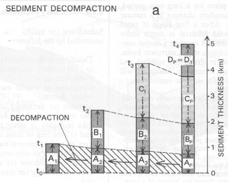
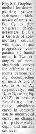
4 Backstripping 1. Dekompaktion 2. sediment load isostasy (3. paleo-bathymetry & sea-level change) 4


5 Young rift zones passive margin subsidence models Profil durch den Atlantik-Schelf vor Baltimore, USA nach Bouma et al. (1982) 5


6 cm/ka Grand Banks area (off Newfoundland) 6
 a, b foreland")
7 Grand Banks area (off Newfoundland) a, b foreland basins 7
8 Beckenanalyse 2. Genetische stratigraphische Konzepte CYCLIC BEDDING 8


.")

9 Sequenzstratigraphie Das Konzept der Sequenzstratigraphie beruht auf dem Zusammenspiel von Sedimentzufuhr und Akkomodationsraum, letzterer wird gesteuert über eustatische Meeresspiegelschwankungen und Subsidenz bzw. Hebung (Raten!). sedimentary response to perturbations of the equilibrium profile caused by uplift / subsidence and/or sea level change 9


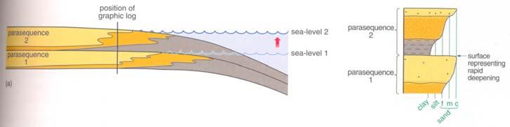
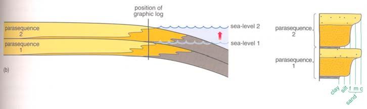
10 The simplest way to understand sequence stratigraphy is to consider the interface area between coastal and shallow-marine siliciclastic depositional environments where changes in relative sea level are easiest to interpret. The parasequence forms the smallest and simplest unit in the framework of sequence stratigraphy. It results from a small-amplitude, short-term oszillation in the balance between sediment supply and accomodation space. Example: coastal environment: 10
11 11
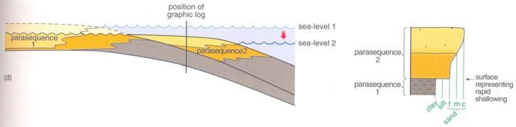
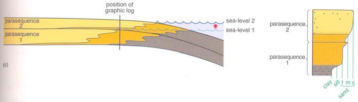
12 Parasequence Sets 12


 cycles above parasequences.")

, and/or changes in sediment supply.")
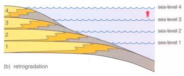
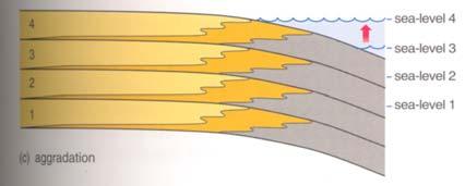
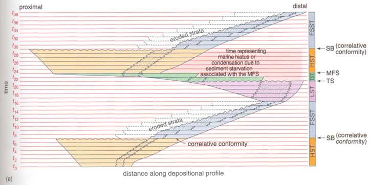
13 Parasequence Sets forced regression Sequences and System Tracts A sequence or depositional sequence is composed of a succession of parasequence sets. Each sequence represents one cycle of change in the balance between accomodation space and sediment supply. Sequences generally range in thickness from a few meter to tens or even hundreds of m, and they are the next larger (or longer duration) cycles above parasequences. Similar to parasequences, sequences are the result of changes in eustatic sea-level and/or subsidence/uplift resulting in a changing relative sea-level ( accomodation space, see below), and/or changes in sediment supply. eustatic sea level + subsidence relative sea-level 13

 - Falling Stage Systems Tract (FSST) - Lowstand Systems Tract (LST) - Transgressive Systems Tract (TST) The high number of different")
14 relative sea-level curves Fig. 4.8b: blue curve taken from Fig. 4.8a; purple curve combines blue curve with short-term changes in accomodation space associated with the development of parasequences. Every sequence is composed of up to four systems tracts, each of which represents a specific part in the cyclic change in the balance between accomodation space and sediment supply. Each systems tract is made up of at least one parasequence set. Different conditions may result in one or more of the systems tracts not being developed or preserved. The four systems tracts are: - Highstand Systems Tract (HST) - Falling Stage Systems Tract (FSST) - Lowstand Systems Tract (LST) - Transgressive Systems Tract (TST) The high number of different factors involved in any one geological situation (such as climate, eustatic sea-level change, subsidence rate, sediment supply, lithology,...) means that the resultant sequences are highly variable. However, every sequence has similar genetic components related to changes in the rate of accomodation space creation and sediment supply. Because the geometry of the basin floor is crucial to the evolution of depositional sequences and systems tracts, we will consider in the following to principal types of depositional profiles from the land to the sea: shelf-break margin ramp margin 14


15 The Highstand Systems Tract (HST) shelf-break margin (c) (d) ramp margin 15


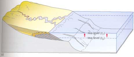
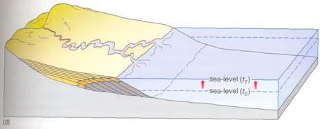
16 Sequence Boundary (SB) Coe et al ramp margin 16


17 The Falling Stage Systems Tract (FSST) shelf-break margin (c) submarine fans deposited at base of continental slope (d) ramp margin 17


 decreasing")


18 Different geometries of Falling Stage Systems Tracts on ramp type margins increasing rate of relative sea-level fall or (and) decreasing rate of sediment supply old young Loss of accomodation space caused by relative sea-level fall A + B << B C + D D 18


 (c)")
19 The Lowstand Systems Tract (LST) ramp margin (d) (c) shelf-break margin 19
 The")
 (a) 20")
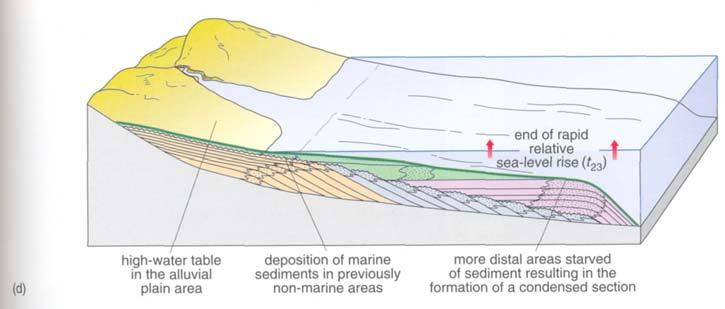
20 Transgressive Surface (TS) The Transgressive Systems Tract (TST) (a) 20
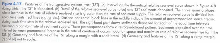
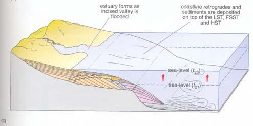
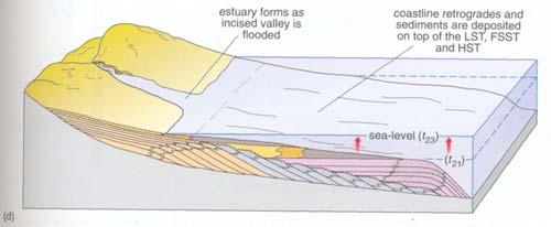
21 shelf-break margin (c) (d) ramp margin Maximum FloodingSurface (MFS) 21
22 22
Beckenanalyse 2. Genetische stratigraphische Konzepte
 Beckenanalyse 2. Genetische stratigraphische Konzepte Einsele 2000 CYCLIC BEDDING Einsele 2000 1 Sequenzstratigraphie Das Konzept der Sequenzstratigraphie beruht auf dem Zusammenspiel von Sedimentzufuhr
Depositional Sequences Sequences
 Depositional Sequences Transgressive and Regressive packages can be bound by unconformities Because sediment can only be preserved during net aggradation and progradation All other times there is either
Sequence Stratigraphy. Historical Perspective
 Sequence Stratigraphy Historical Perspective Sequence Stratigraphy Sequence Stratigraphy is the subdivision of sedimentary basin fills into genetic packages bounded by unconformities and their correlative
4.1 Sediment accommodation space principles and controls
 58 The sedimentary record of sea-level change 4. Sediment accommodation space principles and controls Sequence stratigraphy emphasizes the importance of the space that is made available within a basin
Sequence Stratigraphy as a tool for water resources management in alluvial coastal aquifers: application to the Llobregat delta (Barcelona, Spain)
") Sequence Stratigraphy as a tool for water resources management in alluvial coastal aquifers: application to the Llobregat delta (Barcelona, Spain) Desiré Gàmez Torrent December 2007 CHAPTER 1: Introduction
Sequence Stratigraphy as a tool for water resources management in alluvial coastal aquifers: application to the Llobregat delta (Barcelona, Spain) Desiré Gàmez Torrent December 2007 CHAPTER 1: Introduction
GY 402: Sedimentary Petrology
 UNIVERSITY OF SOUTH ALABAMA GY 402: Sedimentary Petrology Lecture 28: Student Choice Lecture 1: Sequence Stratigraphy Instructor: Dr. Douglas W. Haywick Today Sequence Stratigraphy The basic concept (systems
The Geology of Stratigraphic Sequences
 The Geology of Stratigraphic Sequences Bearbeitet von Andrew Miall 2nd ed. 2010. Buch. xvii, 522 S. Hardcover ISBN 978 3 642 05026 8 Format (B x L): 19,5 x 26 cm Gewicht: 1337 g Weitere Fachgebiete > Geologie,
Sedimentary Basins. Gerhard Einsele. Springer-Verlag Berlin Heidelberg New York London Paris Tokyo Hong Kong Barcelona Budapest
 Gerhard Einsele Sedimentary Basins Evolution, Facies, and Sediment Budget With 269 Figures Springer-Verlag Berlin Heidelberg New York London Paris Tokyo Hong Kong Barcelona Budapest Contents Part I Types
Introduction to sequence stratigraphy and its application to reservoir geology
 Introduction to sequence stratigraphy and its application to reservoir geology Massimo Zecchin Istituto Nazionale di Oceanografia e di Geofisica Sperimentale - OGS Historical development Definitions Systems
Ocean Basins, Bathymetry and Sea Levels
 Ocean Basins, Bathymetry and Sea Levels Chapter 4 Please read chapter 5: sediments for next class and start chapter 6 on seawater for Thursday Basic concepts in Chapter 4 Bathymetry the measurement of
SEQUENCE STRATIGRAPHY
 SEQUENCE STRATIGRAPHY Course of Stratigraphy G301 Second semester (February-June2014) Department of Geology College of Science/University of Basrah Instructor:Dr. Nawrast S. Abd Alwahab Lecture 4 & 5 1
A Simplified Guide For Sequence Stratigraphy:
 SEPM Society for Sedimentary Geology A Simplified Guide For Sequence Stratigraphy: Nomenclature, Definitions and Method Vitor Abreu President - SEPM Abstract All attempts to codify Sequence Stratigraphy
Chapter 2 Plate Tectonics and the Ocean Floor
 Chapter 2 Plate Tectonics and the Ocean Floor Matching. Match the term or person with the appropriate phrase. You may use each answer once, more than once or not at all. 1. hydrothermal vents A. convergent
Sequence Stratigraphy: An Applied Workshop
 Sequence Stratigraphy: An Applied Workshop Instructor: Prof. Octavian Catuneanu Level: Intermediate Duration: 5 days Course Description and Objectives This workshop presents the concepts and practical
Accommodation. Tectonics (local to regional) Subsidence Uplift
 Subsidence Uplift") Accommodation Accommodation varies over time; it is the distance between a reference horizon and the sea surface (i.e. relative sea level). The space to be filled in with sediments or water What are the
Accommodation Accommodation varies over time; it is the distance between a reference horizon and the sea surface (i.e. relative sea level). The space to be filled in with sediments or water What are the
Marine Science and Oceanography
 Marine Science and Oceanography Marine geology- study of the ocean floor Physical oceanography- study of waves, currents, and tides Marine biology study of nature and distribution of marine organisms Chemical
Principles of Sedimentary Basin Analysis
 Principles of Sedimentary Basin Analysis Bearbeitet von Andrew Miall erweitert, überarbeitet 1999. Buch. xxi, 616 S. Hardcover ISBN 978 3 540 65790 3 Format (B x L): 21 x 27,9 cm Gewicht: 1799 g Weitere
Sedimentäre Ablagerungsräume
 Sedimentäre Ablagerungsräume Alluviale Systeme Seen Wüsten Glaziale Systeme Deltas/ Ästuare Skinner & Porter 1989 Deltas und Ästuare Küsten karb.-evap. Systeme Schelf / Schelfmeere Ozeane / Tiefsee Different
Sedimentation on passive margins. Master1 Géologie de l Exploration et des Réservoirs Dynamique des Bassins Michel Séranne
 Sedimentation on passive margins 1 Tectonic-sedimentation relationships at passive margin scale rift Break-up Young margin Sedimentation is controled by continental margin geodynamic evolution Mature margin
Backstripping sediments progressively through geological time.
 Backstripping sediments progressively through geological time. The purpose of backstripping is to use the stratigraphic record to quantitatively estimate the depth that basement would be in the absence
Sediment and Sedimentary rock
 Sediment and Sedimentary rock Sediment: An accumulation of loose mineral grains, such as boulders, pebbles, sand, silt or mud, which are not cemented together. Mechanical and chemical weathering produces
Arc-Continent Collision
 Frontiers in Earth Sciences Arc-Continent Collision Bearbeitet von Dennis Brown, Paul D Ryan 1. Auflage 2011. Buch. xiii, 495 S. Hardcover ISBN 978 3 540 88557 3 Format (B x L): 19,3 x 26 cm Weitere Fachgebiete
Controls on clastic systems in the Angoche basin, Mozambique: tectonics, contourites and petroleum systems
 P2-2-13 Controls on clastic systems in the Angoche basin, Mozambique: tectonics, contourites and petroleum systems Eva Hollebeek, Olivia Osicki, Duplo Kornpihl Schlumberger, London, UK Introduction Offshore
Earth s Continents and Seafloors. GEOL100 Physical Geology Ray Rector - Instructor
 Earth s Continents and Seafloors GEOL100 Physical Geology Ray Rector - Instructor OCEAN BASINS and CONTINENTAL PLATFORMS Key Concepts I. Earth s rocky surface covered by of two types of crust Dense, thin,
Thermal Subsidence Tool in Move
 Thermal Subsidence Tool in Move During the formation of rift basins, the continental crust is stretched and thinned. As it thins, the asthenosphere rises to fill the space created by the thinned continental
Map shows 3 main features of ocean floor
 Map shows 3 main features of ocean floor 2017 Pearson Education, Inc. Chapter 3 Marine Provinces 2017 Pearson Education, Inc. 1 Chapter 3 Overview The study of bathymetry determines ocean depths and ocean
 Sedimentary Basin Analysis http://eqsun.geo.arizona.edu/geo5xx/geos517/ Sedimentary basins can be classified based on the type of plate motions (divergent, convergent), type of the lithosphere, distance
Stratigraphic Trap Identification Based on Restoration of Paleogeophology and Further Division of System Tract: A Case Study in Qingshui Subsag*
 Stratigraphic Trap Identification Based on Restoration of Paleogeophology and Further Division of System Tract: A Case Study in Qingshui Subsag* Cao Laisheng 1, Yu Lin 1, Liu Jianlun 1, Xiang Sheng 1,
Seismic interpretation. Principles of seismic stratigraphic interpretation
 Seismic interpretation Principles of seismic stratigraphic interpretation Seismic interpretation Seismic stratigraphy is a technical for interpreting stratigraphic information from seismic data. The resolution
Understanding Earth Fifth Edition
 Understanding Earth Fifth Edition Grotzinger Jordan Press Siever Chapter 5: SEDIMENTATION: Rocks Formed by Surface Processes Lecturer: H Mohammadzadeh Assistant professors, Department of Geology, FUM Copyright
Bathymetry Measures the vertical distance from the ocean surface to mountains, valleys, plains, and other sea floor features
 1 2 3 4 5 6 7 8 9 10 11 CHAPTER 3 Marine Provinces Chapter Overview The study of bathymetry determines ocean depths and ocean floor topography. Echo sounding and satellites are efficient bathymetric tools.
Lecture 24: Paleozoic 1:
 UNIVERSITY OF SOUTH ALABAMA GY 112: Earth History Lecture 24: Paleozoic 1: Laurentia Instructor: Dr. Douglas W. Haywick Last Time (before the exam) The Cambrian Explosion A) Why a Cambrian explosion B)
Lecture 05: Ocean Basins. Hypsometric Curve. Consider Ocean Basins: What is the elevation of Chambana?
 Lecture 05: Ocean Basins 1 Hypsometric Curve What is the elevation of Chambana? Shows distribution of surface relative to sea level ~67% below sea level Mean ocean depth ~ -3.7 km (well below sea level)
GLY 155 Introduction to Physical Geology, W. Altermann. Press & Siever, compressive forces. Compressive forces cause folding and faulting.
 Press & Siever, 1995 compressive forces Compressive forces cause folding and faulting. faults 1 Uplift is followed by erosion, which creates new horizontal surface. lava flows Volcanic eruptions cover
Full file at
 Essentials of Oceanography, 10e (Trujillo/Keller) Chapter 2 Plate Tectonics and the Ocean Floor Match the term with the appropriate phrase. You may use each answer once, more than once or not at all. A)
Basin Analysis. Stra-graphy
 Basin Analysis Stra-graphy Basin Analysis Basin analysis integrates program sedimentological, stra-graphic, and tectonic principals to develop a full understanding of the rocks that fill sedimentary basins.
Chapter Overview. Bathymetry. Measuring Bathymetry. Measuring Bathymetry
 CHAPTER 3 Marine Provinces Chapter Overview The study of bathymetry determines ocean depths and ocean floor topography. Echo sounding and satellites are efficient bathymetric tools. Most ocean floor features
EDIMENTARY BASINS. What is a Sedimentary Basin? by Prof. Dr. Abbas Mansour
 EDIMENTARY BASINS What is a Sedimentary Basin? by Prof. Dr. Abbas Mansour WHAT IS A SEDIMENTARY BASIN? A low area on the Earth s surface relative to surroundings e.g. deep ocean basin (5-10 km deep) e.g.
Foundations of Earth Science, 6e Lutgens, Tarbuck, & Tasa
 Foundations of Earth Science, 6e Lutgens, Tarbuck, & Tasa Oceans: The Last Frontier Foundations, 6e - Chapter 9 Stan Hatfield Southwestern Illinois College The vast world ocean Earth is often referred
Seismic stratigraphy, some examples from Indian Ocean, interpretation of reflection data in interactive mode
 Seismic stratigraphy, some examples from Indian Ocean, interpretation of reflection data in interactive mode K. S. Krishna National Institute of Oceanography, Dona Paula, Goa-403 004. krishna@nio.org Seismic
Aptian/Albian Reservoir Development in the Jeanne d Arc Basin, Offshore Eastern Canada
 Aptian/Albian Reservoir Development in the Jeanne d Arc Basin, Offshore Eastern Canada Jonathan Marshall, Statoil Canada Ltd. Calgary, Alberta, Canada. jomars@statoil.com Introduction: The Jeanne d Arc
Rockall Plateau. OCN 201: Shelf Sediments
 Rockall Plateau OCN 201: Shelf Sediments Classification by Size Classification by Mode of Formation Detrital sediments Transported and deposited as particles Derived from weathering of pre-existing rocks
Defining the former elevation and shape of the lithosphere, in particular the elevation of the Earth s surface,
 Isostasy in Move Defining the former elevation and shape of the lithosphere, in particular the elevation of the Earth s surface, is important in the restoration of a model as it aids in reducing uncertainty
The Ocean Floor Chapter 14. Essentials of Geology, 8e. Stan Hatfield and Ken Pinzke Southwestern Illinois College
 The Ocean Floor Chapter 14 Essentials of Geology, 8e Stan Hatfield and Ken Pinzke Southwestern Illinois College The vast world ocean Earth is often referred to as the water planet 71% of Earth s surface
The Ocean Floor Earth Science, 13e Chapter 13
 The Ocean Floor Earth Science, 13e Chapter 13 Stanley C. Hatfield Southwestern Illinois College The vast world ocean Earth is often referred to as the blue planet Seventy-one percent of Earth s surface
Quantitative Tarfaya Basin Development, Morocco*
 Quantitative Tarfaya Basin Development, Morocco* Axel Wenke 1, Rainer Zühlke 1, Haddou Jabour 2, Oliver Kluth 3, and Torge Schümann 3 Search and Discovery Article #10420 (2012)** Posted July 16, 2012 *Adapted
GEOLOGY MEDIA SUITE Chapter 5
 UNDERSTANDING EARTH, SIXTH EDITION GROTZINGER JORDAN GEOLOGY MEDIA SUITE Chapter 5 Sedimentation Rocks Formed by Surface Processes 2010 W.H. Freeman and Company Mineralogy of sandstones Key Figure 5.12
MARINE GEOLOGY & GEOGRAPHY
 MARINE GEOLOGY & GEOGRAPHY Bathymetry BATHYMETRY BATHYMETRY THE UNDERWATER EQUIVALENT TO TOPOGRAPHY THE STUDY OF WATER DEPTH A BATHYMETRIC MAP SHOWS FLOOR RELIEF OR TERRAIN AS CONTOUR LINES Bathymetry
Building an Idealized Stra0graphic Sequence Clas0c Shoreline Example William W. Li?le
 Building an Idealized Stra0graphic Sequence Clas0c Shoreline Example William W. Li?le Purpose: The purpose of this exercise is to guide students through the process of construc0ng a stra0graphic sequence
Surface changes caused by erosion and sedimentation were treated by solving: (2)
") GSA DATA REPOSITORY 214279 GUY SIMPSON Model with dynamic faulting and surface processes The model used for the simulations reported in Figures 1-3 of the main text is based on two dimensional (plane strain)
GSA DATA REPOSITORY 214279 GUY SIMPSON Model with dynamic faulting and surface processes The model used for the simulations reported in Figures 1-3 of the main text is based on two dimensional (plane strain)
EARTH SURFACE PROCESSES AND SEDIMENTATION!
 Sed and Strat EARTH SURFACE PROCESSES AND SEDIMENTATION! 2/27 Lecture 7- Exposure: Weathering and the Sediment Factory 3/04 Lecture 8 - Rivers and Landscapes 3/06 Lecture 9 - Waves (not Tides) 3/11 Lecture
Geoscience 001 Fall Rock Identification and Contextual Interpretation
 Geoscience 00 Fall 2005 Rock Identification and Contextual Interpretation The purpose of this week s lab is to gain some more experience and practice in identifying rocks and then interpreting the geologic
Ocean Floor. Continental Margins. Divided into 3 major regions. Continental Margins. Ocean Basins. Mid-Ocean Ridges. Include:
 Ocean Floor Divided into 3 major regions Continental Margins Ocean Basins Mid-Ocean Ridges Continental Margins Include: Continental Shelves Continental Slopes Continental Rise 1 Continental Shelves Part
Master1 Réservoirs Géologiques Architecture des Bassins - Michel Séranne
 1 Tectonic-sedimentation relationships at passive margin scale Outward drainage Bordering Alluvial fans rift Axial Lake (restricted => Preserved OM) Transgressive seq.(evaporites) Sedimentation is controled
Lecture Outlines PowerPoint. Chapter 13 Earth Science 11e Tarbuck/Lutgens
 Lecture Outlines PowerPoint Chapter 13 Earth Science 11e Tarbuck/Lutgens 2006 Pearson Prentice Hall This work is protected by United States copyright laws and is provided solely for the use of instructors
MULTIPLE CHOICE. Choose the one alternative that best completes the statement or answers the question.
 Geology 300, Physical Geology Spring 2019 Quiz Chapter 18, Seafloor Name MULTIPLE CHOICE. Choose the one alternative that best completes the statement or answers the question. 1) Abyssal fans are made
Last Time. Submarine Canyons and Fans. Turbidites. MAS 603: Geological Oceanography. Lecture 16: Greenhouse vs. Icehouse Earths
 UNIVERSITY OF SOUTH ALABAMA Last Time MAS 603: Geological Oceanography Lecture 16: Greenhouse vs. Icehouse Earths Submarine Fans Definition and morphology Transport mechanisms (density currents) Submarine
24. Ocean Basins p
 24. Ocean Basins p. 350-372 Background The majority of the planet is covered by ocean- about %. So the majority of the Earth s crust is. This crust is hidden from view beneath the water so it is not as
GENERAL GEOLOGY Fall Chapter 18: The Sea Floor. Partial Examination IV Study Guide Dr. Glen S. Mattioli
 GENERAL GEOLOGY 1113-005 Fall 2008 Partial Examination IV Study Guide Dr. Glen S. Mattioli Note that these are NOT questions, but rather are a list of topics that we have covered either in class or are
Sequence Stratigraphic Analysis of Mixed, Reefal Carbonate and Siliciclastic Systems. Ashton Embry. Geological Survey of Canada.
 Sequence Stratigraphic Analysis of Mixed, Reefal Carbonate and Siliciclastic Systems Ashton Embry Geological Survey of Canada Outline Sequence Stratigraphy Sequence Surfaces and Sequence Boundaries for
Global Tectonics. Kearey, Philip. Table of Contents ISBN-13: Historical perspective. 2. The interior of the Earth.
 Global Tectonics Kearey, Philip ISBN-13: 9781405107778 Table of Contents Preface. Acknowledgments. 1. Historical perspective. 1.1 Continental drift. 1.2 Sea floor spreading and the birth of plate tectonics.
Biophysics of Macromolecules
 Biophysics of Macromolecules Lecture 11: Dynamic Force Spectroscopy Rädler/Lipfert SS 2014 - Forced Ligand-Receptor Unbinding - Bell-Evans Theory 22. Mai. 2014 AFM experiments with single molecules custom-built
Geography of the world s oceans and major current systems. Lecture 2
 Geography of the world s oceans and major current systems Lecture 2 WHY is the GEOMORPHOLOGY OF THE OCEAN FLOOR important? (in the context of Oceanography) WHY is the GEOMORPHOLOGY OF THE OCEAN FLOOR important?
Geophysics the use of geology, laboratory & field experiments, mathematics, and instruments to study: Earthquakes and Volcanoes seismometers,
 Geophysics the use of geology, laboratory & field experiments, mathematics, and instruments to study: Earthquakes and Volcanoes seismometers, tiltmeters, EDM, remote sensing, Energy: oil, gas, hydrothermal
Th P4 07 Seismic Sequence Stratigraphy Analysis Using Signal Mode Decomposition
 Th P4 07 Seismic Sequence Stratigraphy Analysis Using Signal Mode Decomposition F. Li (University of Olahoma), R. Zhai (University of Olahoma), K.J. Marfurt* (University of Olahoma) Summary Reflecting
Chapter 2. The Planet Oceanus
 Chapter 2 The Planet Oceanus Composition of the Earth The Earth consists of a series of concentric layers or spheres which differ in chemistry and physical properties. There are two different ways to describe
Sequence stratigraphy and basin analysis of the Meso- to Cenozoic Tarfaya- Laayoune Basins, on- and offshore Morocco
 Sequence stratigraphy and basin analysis of the Meso- to Cenozoic Tarfaya- Laayoune Basins, on- and offshore Morocco INAUGURAL-DISSERTATION zur Erlangung der Doktorwtirde der Naturwissenschaftlich-Mathematischen
Accommodation- vs. supply-dominated systems for sediment partitioning to deep water. Supplementary documents
 GSA Data Repository 2019145 1 2 Accommodation- vs. supply-dominated systems for sediment partitioning to deep water Supplementary documents 3 4 5 6 Jinyu Zhang 1, Wonsuck Kim 1, Cornel Olariu 1,2, Ronald
Lecture Marine Provinces
 Lecture Marine Provinces Measuring bathymetry Ocean depths and topography of ocean floor Sounding Rope/wire with heavy weight Known as lead lining Echo sounding Reflection of sound signals 1925 German
GEOL 40290: Basin Analysis
 GEOL 40290: Basin Analysis MODULE COORDINATOR: ADDITIONAL LECTURERS: Prof. Peter Haughton Dr Aggeliki Georgiopoulou Dr Eoghan Holohan CREDITS: 10 MODULE LEVEL: 4 SEMESTER: II PRE-REQUISITES/PRIOR LEARNING:
Seismic interpretation of carbonate turbidites in Central Luconia
 GeoL. Soc. MaLayaia, BuLLetin 47, December 2005; pp. 77-85 Seismic interpretation of carbonate turbidites in Central Luconia FRANcis Ho, GUENTER JAEGER AND PmT LAMBREGTS Sarawak Shell Berhad SMEP Exploration
OCN 201 Physiography of the Seafloor
 OCN 201 Physiography of the Seafloor Hypsometric Curve for Earth s solid surface Note histogram Hypsometric curve of Earth shows two modes. Hypsometric curve of Venus shows only one! Why? Ocean Depth vs.
Temporal significance of sequence boundaries
 ELSEVIER Sedimentary Geology 121 (1998) 157 178 Temporal significance of sequence boundaries Octavian Catuneanu a,ł, Andrew J. Willis b, Andrew D. Miall c a Department of Geology, Rhodes University, Grahamstown
Isostasy, Bathymetry and the Physiography of the Ocean Floor
 Isostasy, Bathymetry and the Physiography of the Ocean Floor EPSS 15 Spring 2017 Ad art for NBC Radio, 1939 Archimedes (c. 287 BCE 212 BCE) Greek mathematician, physicist and engineer Archimedes Principle:
EPSS 15 Introduction to Oceanography Spring Physiography of the Ocean Basins
 EPSS 15 Introduction to Oceanography Spring 2017 Physiography of the Ocean Basins ISOSTASY The surface of the earth can be subdivided into two major areas: 1) the ocean basins and 2) the continents. Although
A Tectonostratigraphic History of Orphan Basin, Offshore Newfoundland, Canada
 A Tectonostratigraphic History of Orphan Basin, Offshore Newfoundland, Canada Lynn T. Dafoe*, Charlotte E. Keen, Graham L. Williams, and Sonya A. Dehler, Geological Survey of Canada, Dartmouth, NS Canada
4. Basins due to orogenic loading
 4. Basins due to orogenic loading Orogenic loading and lithospheric flexure: peripheral vs. retroarc foreland basin Elastic vs. viscoelastic models Gravity anomalies, foreland flexure, and the development
Chapter 4: Sequence Stratigraphy of the Cherokee Group
 Chapter 4: Sequence Stratigraphy of the Cherokee Group 4.1 Sequence Stratigraphic Nomenclature Sequence stratigraphic concepts provide a framework to better explain and predict the lateral distribution,
Image: G. Parker. Presenters: Henry Chan, Kayla Ireland, Mara Morgenstern, Jessica Palmer, Megan Scott
 Image: G. Parker Presenters: Henry Chan, Kayla Ireland, Mara Morgenstern, Jessica Palmer, Megan Scott Is the Ross Formation a suitable analog for sand-rich turbidite plays in passive margin basins? Play:
60% water. Big Bang: 14,000 millions years ago The Earth originated about 4,500 millions years ago its orbit allows water to exist in a liquid state!
 Ch2. The Sea Floor #1 Why geology of the oceans? Marine habitats are directly shaped by geological processes The form of the coastlines The depth of the water Type of bottom (muddy, sandy, rocky) #2 Geological
Plate Tectonics: A Unifying Theory
 Plate Tectonics: A Unifying Theory What is Plate Tectonics? - 7 large tectonic plates and many smaller ones that break up the lithosphere - Plates are brittle and float on asthenosphere and glide past
Topic 5: The Dynamic Crust (workbook p ) Evidence that Earth s crust has shifted and changed in both the past and the present is shown by:
 Evidence that Earth s crust has shifted and changed in both the past and the present is shown by:") Topic 5: The Dynamic Crust (workbook p. 65-85) Evidence that Earth s crust has shifted and changed in both the past and the present is shown by: --sedimentary horizontal rock layers (strata) are found
Topic 5: The Dynamic Crust (workbook p. 65-85) Evidence that Earth s crust has shifted and changed in both the past and the present is shown by: --sedimentary horizontal rock layers (strata) are found
SEDIMENTARY BASINS Red Sea Coast of Egypt. by Prof. Dr. Abbas Mansour
 SEDIMENTARY BASINS Red Sea Coast of Egypt by Prof. Dr. Abbas Mansour Sedimentary basins Sedimentary basins are, in a very broad sense, all those areas in which sediments can accumulate to considerable
In 1990, 50% of the U.S. population lived within 75 km of a coast. By 2010, 75% of the U.S. population will live within 75 km of a coast.
 In 1990, 50% of the U.S. population lived within 75 km of a coast. By 2010, 75% of the U.S. population will live within 75 km of a coast. High Tech Methods for Surveying the Deep Sea Floor Fig. 20.18 1
Arthur Saller 1. Search and Discovery Article #51393 (2017)** Posted June 26, Abstract
** Posted June 26, Abstract") PS Mixed Carbonates and Siliciclastics North of the Mahakam Delta, Offshore East Kalimantan, Indonesia* Arthur Saller 1 Search and Discovery Article #51393 (2017)** Posted June 26, 2017 *Adapted from poster
PS Mixed Carbonates and Siliciclastics North of the Mahakam Delta, Offshore East Kalimantan, Indonesia* Arthur Saller 1 Search and Discovery Article #51393 (2017)** Posted June 26, 2017 *Adapted from poster
Lab 7: Sedimentary Structures
 Name: Lab 7: Sedimentary Structures Sedimentary rocks account for a negligibly small fraction of Earth s mass, yet they are commonly encountered because the processes that form them are ubiquitous in the
Mesozoic Earth History
 Mesozoic Earth History The Mesozoic Era 251-66 MYA Breakup of Pangea Changes in air and oceanic currents Evolution of new terrestrial and marine life Opening of the Atlantic Ocean Basin Rocky Mountains
Chapter 9 Lecture Outline. Oceans: The Last Frontier
 Chapter 9 Lecture Outline Oceans: The Last Frontier The Vast World Ocean Earth is referred to as the blue planet 71% of Earth s surface is oceans and marginal seas Continents and islands comprise the remaining
Continental-margin response to sea level: Theory and Experiment
 Continental-margin response to sea level: Theory and Experiment John B. Swenson Department of Geological Sciences and Large Lakes Observatory, University of Minnesota Duluth Chris Paola, Wonsuck Kim, Ben
Oceanography. Oceanography is the study of the deep sea and shallow coastal oceans.
 Oceanography Oceanography is the study of the deep sea and shallow coastal oceans. Studying the Ocean Floor To determine the shape and composition of the ocean floor, scientists use techniques such as
Importance of Understanding Coastal Landforms
 Importance of Understanding Coastal Landforms Costa Concordia Shipwreck, Isola del Giglio, Italy Depositional Coastal Landforms Can interpret landforms in light of geomorphic processes, both terrestrial
isimm (integrated Seismic Imaging & Modelling of Margins)
") NERC/DTI Ocean Margins Thematic Programme isimm (integrated Seismic Imaging & Modelling of Margins) PIs - Nick Kusznir & Bob White Liverpool University, Cambridge University Co-PIs - Phil Christie & Alan
NERC/DTI Ocean Margins Thematic Programme isimm (integrated Seismic Imaging & Modelling of Margins) PIs - Nick Kusznir & Bob White Liverpool University, Cambridge University Co-PIs - Phil Christie & Alan
QUATERNARY GEOLOGICAL MAP OF THE CONTINENTAL SHELF OF VIETNAM AT THE SCALE OF 1:1,000,000
 VNU. JOURNAL OF SCIENCE, Earth sciences, T.xxIII, N 0 1, 2007 QUATERNARY GEOLOGICAL MAP OF THE CONTINENTAL SHELF OF VIETNAM AT THE SCALE OF 1:1,000,000 Tran Nghi, Dinh Xuan Thanh, Nguyen Thanh Lan, Tran
OCN 201 Physiography of the Seafloor
 OCN 201 Physiography of the Seafloor 1 Ocean Depth versus Continental Height Why do we have dry land? Solid surface of Earth is dominated by two levels: Land with a mean elevation of +840 m (29% of Earth
Questions and Topics
 Plate Tectonics and Continental Drift Questions and Topics 1. What are the theories of Plate Tectonics and Continental Drift? 2. What is the evidence that Continents move? 3. What are the forces that
SEQUENCE STRATIGRAPHY OF THE COAL BEARING OTTNANGIAN (?) - KARPATHIAN SEDIMENT SERIES IN THE EAST BORSOD BASIN (N-HUNGARY)
 - KARPATHIAN SEDIMENT SERIES IN THE EAST BORSOD BASIN (N-HUNGARY)") SEQUENCE STRATIGRAPHY OF THE COAL BEARING OTTNANGIAN (?) - KARPATHIAN SEDIMENT SERIES IN THE EAST BORSOD BASIN (N-HUNGARY) Z. PÜSPÖKI, M. KOZÁK, L. VINCZE and R. MCINTOSH University of Debrecen, Department
SEQUENCE STRATIGRAPHY OF THE COAL BEARING OTTNANGIAN (?) - KARPATHIAN SEDIMENT SERIES IN THE EAST BORSOD BASIN (N-HUNGARY) Z. PÜSPÖKI, M. KOZÁK, L. VINCZE and R. MCINTOSH University of Debrecen, Department
Copyright McGraw-Hill Education. All rights reserved. No reproduction or distribution without the prior written consent of McGraw-Hill Education
 Copyright McGraw-Hill Education. All rights reserved. No reproduction or distribution without the prior written consent of McGraw-Hill Education Tibetan Plateau and Himalaya -southern Asia 11.00.a VE 10X
Neogene Uplift of The Barents Sea
 Neogene Uplift of The Barents Sea W. Fjeldskaar A. Amantov Tectonor/UiS, Stavanger, Norway FORCE seminar April 4, 2013 The project (2010-2012) Funding companies Flat Objective The objective of the work
Geologic Structures. Changes in the shape and/or orientation of rocks in response to applied stress
 Geologic Structures Changes in the shape and/or orientation of rocks in response to applied stress Figure 15.19 Can be as big as a breadbox Or much bigger than a breadbox Three basic types Fractures >>>
Earth s Structure and Surface
 Earth s Structure and Surface Structure of the Earth The earth is thought have originated about 4.5 billion years ago from a cloud or clouds of dust. The dust was the remains of a huge cosmic explosion