Sedimentäre Ablagerungsräume
|
|
|
- Estella Watkins
- 5 years ago
- Views:
Transcription


1 Sedimentäre Ablagerungsräume Alluviale Systeme Seen Wüsten Glaziale Systeme Deltas/ Ästuare Skinner & Porter 1989 Deltas und Ästuare Küsten karb.-evap. Systeme Schelf / Schelfmeere Ozeane / Tiefsee Different delta types controlled by wave and tidal energy Fig b Different types of large marine deltas controlled by waves and tidal currents (LE, ME, HE: low, medium, and high energy conditions, respectively) as well as sediment input (Hi, MI: high or medium input). Einsele


2 fluvial-dominated bird-foot delta the example of the Mississippi Delta/ New Orleans Press & Siever 2001 Coarsening Upward Leeder


3 Reading 1996 Leeder


4 Reading 1996 Classification of modern deltas by Orton & Reading (1993) Beispiel: Nil-Delta Delta - Ebene Delta - Front Pro - Delta Einsele


5 Einsele


6 Einsele 2000 Ästuare - Trichterform - Brackwasser-Verhältnisse (je nach Zirkulationsmuster) - Sediment-Input fluviatil und marin - fluviatile Prozesse - marine Prozesse (Tiden- und Wellenenergie) -... Reading

 Typ D: theoretical endmember lateral and vertical homogeneity")
7 Mischung Unterschiedliche Mischung Flusswasser Meerwasser aufgrund unterschiedllicher Zirkulationsmuster Einsele 2000 Typ A: well-stratified salt wedge estuaries river dominated, tidal and wave mixing processes are permanently or temporarily at a minimum Typ B: partially stratified tidal turbulence has destroyed upper salt wedge interface gradual salinity gradient from bed to surface water Leeder 1999 Typ C: well-mixed strong tidal currents completely destroy the salt wedge to fresh-water interface no more vertical salinity gradients ( vertically mixed -type of Einsele, 2000) Typ D: theoretical endmember lateral and vertical homogeneity of salinity 7

, Sediment vom Meer - netto-transport landwärts - zentrale Zone: relativ")
, netto Sedimenttransport seewärts Walker")
8 Ästuare Ästuare zeigen prinzipiell eine Teilung in drei Zonen mit unterschiedlichen Fazies- Abfolgen (Korngrößen, Sedimentstrukturen, Biofazies, Ichnofazies...). - äußere Zone: domininiert von marinen Prozessen (Wellen u./o. Tide), Sediment vom Meer - netto-transport landwärts - zentrale Zone: relativ geringe Energie, relativ feinkörnige Sedimente - innere Zone: fluviatil dominiert, aber mariner Einfluß (Tide), netto Sedimenttransport seewärts Walker 1992 a Reading


9 Beispiel: Gironde Reading


10 10 km Beispiel: Deutsche Bucht Reading 1996 Rand- Meere Einsele


11 Beispiel: Schwarzes Meer Einsele


12 Küsten / Schelf Reading 1996 Press & Siever 2001 wave base Reading


13 Küsten Reading 1996 Jacobshagen et al Ausgleichsküsten Bahlburg & Breitkreuz


14 Einsele 2000 Einsele


15 Reading 1996 Einsele


16 storm-dominated shallow-marine environments Einsele 2000 Einsele


17 Reading 1996 Reading


18 Reading 1996 Coast to offshore trends Leeder


19 Gezeiten A Press & Siever 2001 Schwerpunkt B Springtide und Nipptide Walker


20 Siliciclastic tidal flats ( Wattenmeer ) Walker 1992 Einsele


21 tidal bundles Reading 1996 slack water = Stillwasser Reading


22 Coastal morphology vs. wave and tidal energy Leeder 1999 Leeder


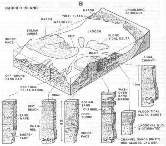
23 b barrier islands Coe 2003 c Einsele


24 Schelfgebiete Ozean/Tiefsee Topographisches Profil des Ozeanbodens im Atlantik von Neu-England bis Gibraltar Press & Siever


25 Tiefenbereiche Jacobshagen et al pycnocline: transitional layer between shallow upper water layer and deep water ; it may frequently also act as a thermocline and/or chemocline/halocline ( salinity) Einsele

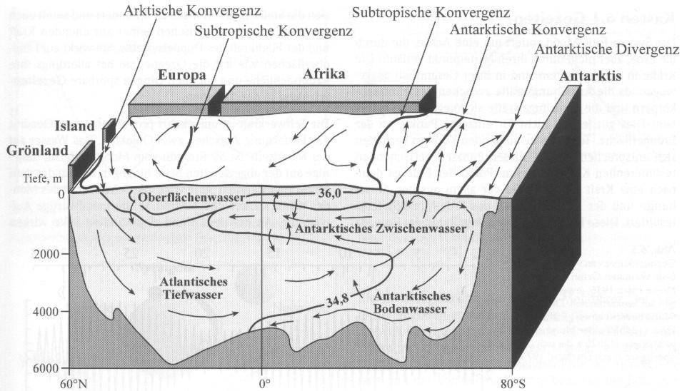

26 Strömungen / Wasserzirkulation Degens 1989 Degens 1989 Bahlburg & Breitkreuz
, whereas")
 concentrated.")
.")
27 Material-/ Nährstoffzufuhr Leeder 1999 CCD Carbonate shells dissolve in deep water below CCD (low T, high P), whereas silica shells and/or reddishbrown clay minerals are (relatively) concentrated. Silica shells may accumulate in purely siliceous oozes which are later transformed to cherts (diagenesis). + variations in time! Jacobshagen et al Einsele

28 Einsele 2000 Sediment distribution and deposition in deep sea environments roter Tiefseeton Degens
: ~3000m Relief im Canyon: >2500m Canyon-Breite")

29 Submarine Canyons max. Tiefe (NN): ~3000m Relief im Canyon: >2500m Canyon-Breite am Top: ~ 10 km Echo-sounding profile of the Congo submarine canyon off Zaire, African west coast vertical exaggeration ~8 Press & Siever 2001 Leeder


30 Example: Amazon fan Leeder 1999 Leeder


31 Einsele 2000 Einsele


32 Leeder 1999 Trübeströme Leeder


33 33
Depositional Environment
 Depositional Environment Sedimentary depositional environment describes the combination of physical, chemical and biological processes associated with the deposition of a particular type of sediment. Types
Sedimentary Basins. Gerhard Einsele. Springer-Verlag Berlin Heidelberg New York London Paris Tokyo Hong Kong Barcelona Budapest
 Gerhard Einsele Sedimentary Basins Evolution, Facies, and Sediment Budget With 269 Figures Springer-Verlag Berlin Heidelberg New York London Paris Tokyo Hong Kong Barcelona Budapest Contents Part I Types
Beckenanalyse 2. Genetische stratigraphische Konzepte
 Beckenanalyse 2. Genetische stratigraphische Konzepte Einsele 2000 CYCLIC BEDDING Einsele 2000 1 Sequenzstratigraphie Das Konzept der Sequenzstratigraphie beruht auf dem Zusammenspiel von Sedimentzufuhr
Main issues of Deltas
 Global sediment supply to coastal seas and oceans; location of major river deltas RIVER DELTAS Depositional processes - Course Coastal Morphodynamics GEO3-436; lecture 4 Nile Delta, Egypt Solo Delta, Java,
L7/ Historical Perspec=ve, Deltas
 Colin Woodroffe (2002) Coasts: Form, Process and Evolu=on, Outline of Chapter 7: L7/1 L7/2 7.1. Historical Perspec=ve, 7.1.1. Deltas Herodotus (450, B.C.) delta = Shape of Nile River Delta = Δ Gilbert
Chapter 9 Lecture Outline. Oceans: The Last Frontier
 Chapter 9 Lecture Outline Oceans: The Last Frontier The Vast World Ocean Earth is referred to as the blue planet 71% of Earth s surface is oceans and marginal seas Continents and islands comprise the remaining
Foundations of Earth Science, 6e Lutgens, Tarbuck, & Tasa
 Foundations of Earth Science, 6e Lutgens, Tarbuck, & Tasa Oceans: The Last Frontier Foundations, 6e - Chapter 9 Stan Hatfield Southwestern Illinois College The vast world ocean Earth is often referred
h m h a + ρ c h c + ρ a + ρ m
 Beckenanalyse 1. Subsidenz Hohe Sediment-Akkumulation und die Bildung Sedimentärer Becken sind nicht möglich ohne entsprechenden Subsidenz. Subsidenz beschreibt die Senkung der Erdoberfläche (Landoberfläche
Understanding Earth Fifth Edition
 Understanding Earth Fifth Edition Grotzinger Jordan Press Siever Chapter 5: SEDIMENTATION: Rocks Formed by Surface Processes Lecturer: H Mohammadzadeh Assistant professors, Department of Geology, FUM Copyright
NAME: GEL 109 Final Winter 2010
 GEL 109 Final Winter 2010 1. The following stratigraphic sections represents a single event followed by the slow accumulation of background sedimentation of shale. Describe the flows that produced the
Understanding The Seafloor. Dr. Frank R. Hall. Resources for pictures, etc. used in this presentation
 Slide 1 Understanding The Seafloor Dr. Frank R. Hall Geological Oceanographer University of New Orleans New Orleans, LA 2003 This is a presentation prepared in the Summer 2003 for the Gulf Coast COSSEE
ES120 Sedimentology/Stratigraphy
 Midterm Exam 5/05/08 NAME: 1. List or describe 3 physical processes that contribute to the weathering of rocks (3pts). exfoliation frost wedging many others. roots, thermal expansion/contraction also credit
Chapter 5. The Sedimentary Archives
 Chapter 5 The Sedimentary Archives Factors affecting Sedimentary Characteristics 1. Tectonic setting 2. Physical, chemical, and biological processes in the depositional environment 3. Method of sediment
1 Shoreline Landforms 2. 2 Emergent v. Submergent 2. 3 Wavecutting 3. 4 Planview 4. 5 Marine Terraces 5. 6 California 7. 7 Tombolos, Sea Stacks 8
 Shorelines November 9, 2008 Contents 1 Shoreline Landforms 2 2 Emergent v. Submergent 2 3 Wavecutting 3 4 Planview 4 5 Marine Terraces 5 6 California 7 7 Tombolos, Sea Stacks 8 8 Active Processes 9 9 Emergence
Sediment and Sedimentary rock
 Sediment and Sedimentary rock Sediment: An accumulation of loose mineral grains, such as boulders, pebbles, sand, silt or mud, which are not cemented together. Mechanical and chemical weathering produces
PRINCIPLE OF OCEANOGRAPHY PBBT101 UNIT-1 INTRODUCTION OF OCEANIC ENVIRONMENT. PART-A (2 Marks)
") PRINCIPLE OF OCEANOGRAPHY PBBT101 UNIT-1 INTRODUCTION OF OCEANIC ENVIRONMENT 1. Define marine ecosystem. 2. What is geography? 3. Give two Oceanic zones 4. What is sea? 5. Define oceanography? 6. Enlist
PRINCIPLE OF OCEANOGRAPHY PBBT101 UNIT-1 INTRODUCTION OF OCEANIC ENVIRONMENT 1. Define marine ecosystem. 2. What is geography? 3. Give two Oceanic zones 4. What is sea? 5. Define oceanography? 6. Enlist
GLG Chapter 7 Sedimentary Environments & Rocks
 GLG 101 - Chapter 7 Sedimentary Environments & Rocks Name Note, Oct 11: I ll be writing this study sheet over the next few days. Each day I will add questions until the entire chapter is done, hopefully
MISSISSIPPI RIVER DELTA OVERVIEW
 MISSISSIPPI RIVER DELTA OVERVIEW Science and Engineering Special Team Conference Louisiana State University October 9, 2012 Introduction Basics of the Mississippi Delta Natural and Human-Induced Land Loss
The boundary between two formations (or any distinct layers) is called a contact. Sedimentary rocks cover 75% of continents.
 is called a contact. Sedimentary rocks cover 75% of continents.") Sedimentary Rocks Sedimentary rocks form at the Earth s surface through interactions of the hydrologic system and the crust. Fortunately, many of these processes are in operation today, and geologists
Sedimentary Rocks Sedimentary rocks form at the Earth s surface through interactions of the hydrologic system and the crust. Fortunately, many of these processes are in operation today, and geologists
3.3 Classification Diagrams Estuarine Zone Coastal Lagoons References Physical Properties and Experiments in
 Contents 1 Introduction to Estuary Studies... 1 1.1 Why to Study Estuaries?.... 1 1.2 Origin and Geological Age... 4 1.3 Definition and Terminology... 7 1.4 Policy and Actions to Estuary Preservation....
The Ocean Floor Chapter 14. Essentials of Geology, 8e. Stan Hatfield and Ken Pinzke Southwestern Illinois College
 The Ocean Floor Chapter 14 Essentials of Geology, 8e Stan Hatfield and Ken Pinzke Southwestern Illinois College The vast world ocean Earth is often referred to as the water planet 71% of Earth s surface
Reading Material. See class website. Sediments, from Oceanography M.G. Gross, Prentice-Hall
 Reading Material See class website Sediments, from Oceanography M.G. Gross, Prentice-Hall Materials filling ocean basins Dissolved chemicals especially from rivers and mid-ocean ridges (volcanic eruptions)
Question. What caused the recent explosive eruptions of hot ash and gas at Kilauea s Halema uma u crater:
 OCN 201 Deep Sea Sediments Question What caused the recent explosive eruptions of hot ash and gas at Kilauea s Halema uma u crater: A. The interaction of lava with seawater B. Drainage of the lava lake
OCN 201: Deep-Sea Sediments
 OCN 201: Deep-Sea Sediments Eric Heinen De Carlo, F2011 Where is the Sediment? Continental Margins: 87% (covers ~21% of ocean area) Deep-ocean floor: 13% ~21% ~87% Sediment Deposition Rates (time to deposit
Physical Oceanography
 Physical Oceanography SECTION 15.1 The Oceans In your textbook, read about modern oceanography. For each item in Column A, write the letter of the matching item in Column B. e b c d a Column A 1. German
Marine Sediments. Introductory Oceanography. Ray Rector: Instructor
 Marine Sediments Introductory Oceanography Ray Rector: Instructor Ocean Basins are Vast Sinks for Huge Amounts of Sediment from Numerous Different Sources Four Major Types of Seafloor Sediments 1. Lithogenous
Lecture 1: Scope, assessment and structure of course; Introduction to Sedimentology and Basic Definitions: uses and applications of Sedimentology.
 GEOL 440 Sedimentology and stratigraphy: processes, environments and deposits Jim Best MWF: Lectures and F: Laboratory Class Bruce Fouke Lecture 1: Scope, assessment and structure of course; Introduction
Lecture Outlines PowerPoint. Chapter 13 Earth Science 11e Tarbuck/Lutgens
 Lecture Outlines PowerPoint Chapter 13 Earth Science 11e Tarbuck/Lutgens 2006 Pearson Prentice Hall This work is protected by United States copyright laws and is provided solely for the use of instructors
Marine Science and Oceanography
 Marine Science and Oceanography Marine geology- study of the ocean floor Physical oceanography- study of waves, currents, and tides Marine biology study of nature and distribution of marine organisms Chemical
Pre-Lab Reading Questions ES202
 ES202 The are designed to encourage students to read lab material prior to attending class during any given week. Reading the weekly lab prior to attending class will result in better grade performance
The Marine Environment
 The Marine Environment SECTION 16.1 Shoreline Features In your textbook, read about erosional landforms, beaches, estuaries, longshore currents, and rip currents. For each statement below, write true or
Sedimentary Environments Chapter 8
 Sedimentary Environments Chapter 8 Does not contain complete lecture notes. To be used to help organize lecture notes and home/test studies. What is a sedimentary rock? Sedimentary rocks are products of
The Marine Environment
 The Marine Environment SECTION 16.1 Shoreline Features In your textbook, read about erosional landforms, beaches, estuaries, longshore currents, and rip currents. For each statement below, write or. 1.
Coastal Oceanography. Coastal Oceanography. Coastal Waters
 Coastal Oceanography Coastal Oceanography 95% of ocean life is in coastal waters (320 km from shore) Estuaries and wetlands are among most productive ecosystems on Earth Major shipping routes, oil and
Lecture Outline Wednesday - Friday February 14-16, 2018
 Lecture Outline Wednesday - Friday February 14-16, 2018 Quiz 2 scheduled for Friday Feb 23 (Interlude B, Chapters 6,7) Questions? Chapter 6 Pages of the Past: Sedimentary Rocks Key Points for today Be
Subtidal permanently flooded with tidal water. Irregularly exposed surface exposed by tides less often than daily
 Types of Wetlands Tidal Systems COASTAL WETLAND ECOSYSTEMS Tidal Salt Marshes Tidal Freshwater Marshes Mangrove Wetlands Tidal Estuarine Wetland 1 Definition and Formation of Estuaries u Estuary : partially
Types of Wetlands. Tidal Systems
 Types of Wetlands Tidal Systems 1 COASTAL WETLAND ECOSYSTEMS Tidal Salt Marshes Tidal Freshwater Marshes Mangrove Wetlands 2 Tidal Estuarine Wetland 3 Definition and Formation of Estuaries Estuary: : partially
Lecture 26: Marine Geology Read: Chapter 21 Homework due December 3
 Learning Objectives (LO) Lecture 26: Marine Geology Read: Chapter 21 Homework due December 3 What we ll learn today:! 1. Describe the world s five oceans! 2. Understand patterns of ocean circulation! 3.
Paleo Lab #4 - Sedimentary Environments
 Paleo Lab #4 - Sedimentary Environments page - 1. CHARACTERISTICS OF SEDIMENT Grain size and grain shape: The sizes and shapes of sedimentary particles (grains) are modified considerably during their transportation
ARE YOU READY TO THINK? Look at the first slide THINK PAIR SHARE!
 ARE YOU READY TO THINK? Look at the first slide THINK PAIR SHARE! WHAT PROMINENT FEATURE CAN YOU IDENTIFY IN THIS PICTURE? What do you think the different colors represent? Who might find such a picture
Sediments and Sedimentary Rocks
 Sediments and Sedimentary Rocks (Shaping Earth s Surface, Part 2) Science 330 Summer 2005 What is a sedimentary rock? Products of mechanical and chemical weathering Account for about 5 percent of Earth
Processes affecting continental shelves
 Marine Sediments Continental Shelves Processes affecting continental shelves 1. Glaciation 2. Sea-level change (±130 m during continental glaciation) 3. Waves and currents 4. Sedimentation 5. Carbonate
In 1990, 50% of the U.S. population lived within 75 km of a coast. By 2010, 75% of the U.S. population will live within 75 km of a coast.
 In 1990, 50% of the U.S. population lived within 75 km of a coast. By 2010, 75% of the U.S. population will live within 75 km of a coast. High Tech Methods for Surveying the Deep Sea Floor Fig. 20.18 1
Ocean and Coastal Processes. Ocean Basins. Chapter 20. Ocean Basins and Plates. Ocean Terms. Sea Arch Bay-mouth Bar Spit Tombolo Coast.
 Chapter 20 Ocean Basins and Plates Ocean and Coastal Processes Tide Wave Height Length Period Base Refraction Tsunami Beach Sea stack Ocean Terms Sea Arch Bay-mouth Bar Spit Tombolo Coast Emergent Submergent
Chapter 17. Ocean and Coastal Processes
 Chapter 17 Ocean and Coastal Processes Ocean Basins and Plates Ocean Basins Ocean Basins are profoundly different from the continents. Ocean crust is thin and dense and young. New ocean crust is generated
EARTH SURFACE PROCESSES AND SEDIMENTATION!
 Sed and Strat EARTH SURFACE PROCESSES AND SEDIMENTATION! 2/27 Lecture 7- Exposure: Weathering and the Sediment Factory 3/04 Lecture 8 - Rivers and Landscapes 3/06 Lecture 9 - Waves (not Tides) 3/11 Lecture
Oceans I Notes. Oceanography
 Oceans I Notes Outlines on the front table Oceanography the science of our oceans that mixes biology, geology, chemistry, and physics (among other sciences) to unravel the mysteries of our seas. Divisions
Chapter 3 Sedimentation of clay minerals
 Chapter 3 Sedimentation of clay minerals 3.1 Clay sedimentation on land 3.2 From land to sea 3.3 Clay sedimentation in the sea 1 3.1 Clay sedimentation on land Deserts Glaciers Rivers Lacustrine 2 University
Oceanography. Oceanography is the study of the deep sea and shallow coastal oceans.
 Oceanography Oceanography is the study of the deep sea and shallow coastal oceans. Studying the Ocean Floor To determine the shape and composition of the ocean floor, scientists use techniques such as
Chapter 2. Denudation: Rivers and Ice
 Chapter 2. Denudation: Rivers and Ice DENUDATION: process that lowers level of land - caused by rivers, glaciers, waves & wind - involves processes of WEATHERING & EROSION Weathering Def: breakdown of
Map shows 3 main features of ocean floor
 Map shows 3 main features of ocean floor 2017 Pearson Education, Inc. Chapter 3 Marine Provinces 2017 Pearson Education, Inc. 1 Chapter 3 Overview The study of bathymetry determines ocean depths and ocean
Lecture 9+10: Buoyancy-driven flow, estuarine circulation, river plume, Tidal mixing, internal waves, coastal fronts and biological significance
 Lecture 9+10: Buoyancy-driven flow, estuarine circulation, river plume, Tidal mixing, internal waves, coastal fronts and biological significance Thermohaline circulation: the movement of water that takes
Facies Cryptic description Depositional processes Depositional environments Very well sorted. Desert dunes. Migration of straight crested mega ripples
 Very well sorted Travelled grate distance, effective sorting 5 medium-grained sandstone with well rounded grains; large scale high angle planar cross-beds. Migration of straight crested mega ripples Desert
The Ocean Floor Earth Science, 13e Chapter 13
 The Ocean Floor Earth Science, 13e Chapter 13 Stanley C. Hatfield Southwestern Illinois College The vast world ocean Earth is often referred to as the blue planet Seventy-one percent of Earth s surface
Lab 7: Sedimentary Structures
 Name: Lab 7: Sedimentary Structures Sedimentary rocks account for a negligibly small fraction of Earth s mass, yet they are commonly encountered because the processes that form them are ubiquitous in the
The surface of the ocean floor is as varied as the land. The five major oceans, from largest to smallest, are
 11.1 Ocean Basins The surface of the ocean floor is as varied as the land. The five major oceans, from largest to smallest, are w the Pacific w the Atlantic w the Indian w the Southern w the Arctic The
Sediment and sedimentary rocks Sediment
 Sediment and sedimentary rocks Sediment From sediments to sedimentary rocks (transportation, deposition, preservation and lithification) Types of sedimentary rocks (clastic, chemical and organic) Sedimentary
14.2 Ocean Floor Features Mapping the Ocean Floor
 14.2 Ocean Floor Features Mapping the Ocean Floor The ocean floor regions are the continental margins, the ocean basin floor, and the mid-ocean ridge. 14.2 Ocean Floor Features Continental Margins A continental
Ocean Basins, Bathymetry and Sea Levels
 Ocean Basins, Bathymetry and Sea Levels Chapter 4 Please read chapter 5: sediments for next class and start chapter 6 on seawater for Thursday Basic concepts in Chapter 4 Bathymetry the measurement of
Michael Walsworth, Ryan Sullivan, Simi Odueyungbo, William Budd
 Michael Walsworth, Ryan Sullivan, Simi Odueyungbo, William Budd Estuarine Environment At first (Pritchard, 1967), an estuary was defined by the salinity of the water. Then by Clifton (1982) as an inlet
Oceanography is the scientific study of oceans Oceans make up over 70% of the Earth s surface
 Oceanography Oceanography is the scientific study of oceans Oceans make up over 70% of the Earth s surface An ocean must be large and have features which set it apart from other oceans (currents, water
Year 6. Geography. Revision
 Year 6 Geography Revision November 2017 Rivers and World knowledge How the water cycle works and the meaning of the terms evaporation, condensation, precipitation, transpiration, surface run-off, groundwater
ENVIRONMENTAL FLUID MECHANICS. Estuaries
 ENVIRONMENTAL FLUI MECHANICS Estaries Benoit Cshman-Roisin Thayer School of Engineering artmoth College Estaries are regions where rivers meet the coastal ocean. They are biologically niqe becase these
SEDIMENT TRANSPORT IN RIVER MOUTH ESTUARY
 SEDIMENT TRANSPORT IN RIVER MOUTH ESTUARY Katsuhide YOKOYAMA, Dr.Eng. dredge Assistant Professor Department of Civil Engineering Tokyo Metropolitan University 1-1 Minami-Osawa Osawa, Hachioji,, Tokyo,
The Coast: Beaches and Shoreline Processes
 1 2 3 4 5 6 7 8 9 The Coast: es and Shoreline Processes Trujillo & Thurman, Chapter 10 Oceanography 101 Chapter Objectives Recognize the various landforms characteristic of beaches and coastal regions.
The Coast: Beaches and Shoreline Processes Trujillo & Thurman, Chapter 10
 The Coast: es and Shoreline Processes Trujillo & Thurman, Chapter 10 Oceanography 101 Chapter Objectives Recognize the various landforms characteristic of beaches and coastal regions. Identify seasonal
NAME: GEL 109 Final Study Guide - Winter 2008 Questions 6-24 WILL be on the final exactly as written here; this is 60% of the test.
 GEL 109 Final Study Guide - Winter 2008 Questions 6-24 WILL be on the final exactly as written here; this is 60% of the test. 1. Sketch a map view of three types of deltas showing the differences in river,
Chapter Overview. Bathymetry. Measuring Bathymetry. Measuring Bathymetry
 CHAPTER 3 Marine Provinces Chapter Overview The study of bathymetry determines ocean depths and ocean floor topography. Echo sounding and satellites are efficient bathymetric tools. Most ocean floor features
Section 21.1 pp What is Climate?
 Section 21.1 pp. 466 468 What is Climate? Set a Purpose: TE, p. 466 Reading Study Guide, p. 73 More about How Climate Controls Interact TE, p. 466 Differentiating ion Reading Support: TE, p. 466 Critical
Physical Oceanography
 Physical Oceanography SECTION 15.1 The Oceans In your textbook, read about modern oceanography. For each item in Column A, write the letter of the matching item in Column B. Column A 1. German research
Directed Reading. Section: The Water Planet. surface is called the a. Earth s ocean. b. Pacific Ocean. c. salt-water ocean. d. global ocean.
 Skills Worksheet Directed Reading Section: The Water Planet 1. The body of salt water covering nearly three-quarters of the Earth s surface is called the a. Earth s ocean. b. Pacific Ocean. c. salt-water
Linking Sediment Transport in the Hudson from the Tidal River to the Estuary
 Linking Sediment Transport in the Hudson from the Tidal River to the Estuary Or, what happened to all the mud from Irene? David Ralston, Rocky Geyer, John Warner, Gary Wall Hudson River Foundation seminar
UNIT 4 SEDIMENTARY ROCKS
 UNIT 4 SEDIMENTARY ROCKS WHAT ARE SEDIMENTS Sediments are loose Earth materials (unconsolidated materials) such as sand which are transported by the action of water, wind, glacial ice and gravity. These
Homework 5: Background Ocean Water Properties & Stratification
 14 August 2008 MAR 110 HW5: Ocean Properties 1 Homework 5: Background Ocean Water Properties & Stratification The ocean is a heterogeneous mixture of water types - each with its own temperature, salinity,
II Why study coastal landforms?
 COASTAL LANDFORMS (32) I Main topics A Why study coastal landforms? B Sediment budget and system response C Coastal landforms 3/26/15 GG454 1 II Why study coastal landforms? A Dynamic systems B Reflect
What is weathering and how does it change Earth s surface? Answer the question using
 7 th Grade Lesson What is weathering and how does it change Earth s surface? Answer the question using the sentence frame. You have 4 minutes. Weathering is. This changes the Earth s surface because. 1
MARINE GEOLOGY & GEOGRAPHY
 MARINE GEOLOGY & GEOGRAPHY Bathymetry BATHYMETRY BATHYMETRY THE UNDERWATER EQUIVALENT TO TOPOGRAPHY THE STUDY OF WATER DEPTH A BATHYMETRIC MAP SHOWS FLOOR RELIEF OR TERRAIN AS CONTOUR LINES Bathymetry
Sediment Transport at Density Fronts in Shallow Water: a Continuation of N
 DISTRIBUTION STATEMENT A. Approved for public release; distribution is unlimited. Sediment Transport at Density Fronts in Shallow Water: a Continuation of N00014-08-1-0846 David K. Ralston Applied Ocean
Bathymetry Measures the vertical distance from the ocean surface to mountains, valleys, plains, and other sea floor features
 1 2 3 4 5 6 7 8 9 10 11 CHAPTER 3 Marine Provinces Chapter Overview The study of bathymetry determines ocean depths and ocean floor topography. Echo sounding and satellites are efficient bathymetric tools.
Bell Ringer. water cycle? gaseous water (water vapor)? How do you know? 1. What are the five components of the
? How do you know? 1. What are the five components of the") Bell Ringer 1. What are the five components of the water cycle? 2. Are clouds composed of liquid water or gaseous water (water vapor)? How do you know? 3. How are glaciers formed? Salt Water - Oceans Characteristics
Bell Ringer 1. What are the five components of the water cycle? 2. Are clouds composed of liquid water or gaseous water (water vapor)? How do you know? 3. How are glaciers formed? Salt Water - Oceans Characteristics
SEDIMENTARY ROCKS. Processes, Environments, Structures and Rocks. Sedimentary Processes and Rocks
 SEDIMENTARY ROCKS Processes, Environments, Structures and Rocks Sedimentary Processes and Rocks Origins of Sedimentary Rocks Sediment transport and texture Sedimentary structures Lithification Classifying
Controls on clastic systems in the Angoche basin, Mozambique: tectonics, contourites and petroleum systems
 P2-2-13 Controls on clastic systems in the Angoche basin, Mozambique: tectonics, contourites and petroleum systems Eva Hollebeek, Olivia Osicki, Duplo Kornpihl Schlumberger, London, UK Introduction Offshore
Supplemental Slides. Shore: Junction of Land & Water. Junction of Land & Water. Sea Level Variations. Shore vs. Coast. Sea Level Variations
 Shore: Junction of Land & Water Supplemental Slides Sediments come off land Most get dumped at the beach Sediment interacts with ocean waves and currents Junction of Land & Water Features: Breaking waves,
Shore: Junction of Land & Water. Sediments come off land Most get dumped at the beach Sediment interacts with ocean waves and currents
 Shore: Junction of Land & Water Supplemental Slides Sediments come off land Most get dumped at the beach Sediment interacts with ocean waves and currents Junction of Land & Water Features: Breaking waves,
Integrating new coastline information and geographically coordinated coastal geomorphology data
 Integrating new coastline information and geographically coordinated coastal geomorphology data NOAA Contemporary Shoreline DOE Coastal Geomorphology Cynthia Miller Corbett Jeff Simley 1 National Hydrography
Question: What is the primary reason for the great abundance of fish along the Peruvian coast?
 Buzzer Question # 1 Question Type: toss-up Question Format: Multiple Choice Category: Biology What is the primary reason for the great abundance of fish along the Peruvian coast? Answer W: upwelling Answer
Where is all the water?
 Where is all the water? The distribution of water at the Earth's surface % of total Oceans 97.25 Ice caps and glaciers 2.05 Groundwater 0.68 Lakes 0.01 Soils 0.005 Atmosphere (as vapour) 0.001 Rivers 0.0001
402: Sedimentary Petrology
 UNIVERSITY OF SOUTH ALABAMA 402: Sedimentary Petrology Lecture 14: Siliciclastic Diagenesis Instructor: Dr. Douglas W. Haywick Last Time (online) Immature siliciclastic sediment and sedimentary rocks Pictorial
CHAPTER 6 & 7 VOCABULARY
 CHAPTER 6 & 7 VOCABULARY 1. Biome 2. Climate 3. Latitude 4. Altitude 5. Emergent layer 6. Epiphyte 7. Understory 8. Permafrost 9. Wetland 10.Plankton 11.Nekton 12.Benthos 13.Littoral zone 14.Benthic zone
What is a sedimentary rock?
 Sedimentary Rocks What is a sedimentary rock? Sedimentary rocks are products of mechanical and chemical weathering They account for only 5% of the top 10 miles of the outer crust, yet most of the earth
4. The map below shows a meandering stream. Points A, B, C, and D represent locations along the stream bottom.
 1. Sediment is deposited as a river enters a lake because the A) velocity of the river decreases B) force of gravity decreases C) volume of water increases D) slope of the river increases 2. Which diagram
CHAPTER 1 INTRODUCTION
 1 CHAPTER 1 INTRODUCTION 1.1 GENERAL Washover sandsheets are often found in low-lying coastal embayment s (Sedgwick and Davis 2003). Washover deposition of marine sand is usually attributed to storm activity
Geol 117 Lecture 18 Beaches & Coastlines. I. Types of Coastlines A. Definition:
 I. Types of Coastlines A. Definition: 1. Shore = narrow zone where ocean meets land (e.g. beach) 2. Coast is a broad area where both ocean and land processes act a. Includes onshore marshes, dunes, sea
Unit 8 Test Review -- Oceanography
 Unit 8 Test Review -- Oceanography Multiple Choice Identify the choice that best completes the statement or answers the question. D 1. A large body of saline water that may be surrounded by land is a(n)
For example, for values of A x = 0 m /s, f 0 s, and L = 0 km, then E h = 0. and the motion may be influenced by horizontal friction if Corioli
 Lecture. Equations of Motion Scaling, Non-dimensional Numbers, Stability and Mixing We have learned how to express the forces per unit mass that cause acceleration in the ocean, except for the tidal forces
Hydrological Cycle Rain and rivers OUTLINE
 Hydrological Cycle Rain and rivers The Hydrosphere Rain and rivers OUTLINE 1 Generalizations (non-political conservatism) Conservative (not affected) and Non-Conservative (affected) Ions Distinction: whether
Small area of the ocean that is partially surrounded by land. The Ocean Basins. Three Major Oceans. Three Major Oceans. What is a SEA?
 The Ocean Basins How Deep is the Ocean? 1 2 Three Major Oceans Three Major Oceans Pacific Atlantic the shallowest ocean (3.3km average depth) Indian second shallowest ocean (3.8km average depth) Pacific
Section 2.1 Ocean Basins. - Has helped determine where ocean basins are located. - Tectonic plates move changing the position of the continents.
 Science 8 Unit 1: Water Systems on Earth Chapter 2: Oceans Control the Water Cycle Section 2.1 Ocean Basins Oceans are important because: 1. Primary water source for the water cycle 2. Control weather
Lecture Marine Provinces
 Lecture Marine Provinces Measuring bathymetry Ocean depths and topography of ocean floor Sounding Rope/wire with heavy weight Known as lead lining Echo sounding Reflection of sound signals 1925 German
The Water Planet Ch. 22
 The Water Planet Ch. 22 What is Oceanography? the study of the Earth s oceans using chemistry, biology, geology, and physics. Oceans cover 70% of the Earth s surface Ocean Research 22.1 The use of submarines