Master1 Réservoirs Géologiques Architecture des Bassins - Michel Séranne
|
|
|
- Peter Harrell
- 5 years ago
- Views:
Transcription
1 1

 platform Decaying thermal subsidence Young (hot) oceanic lithosph.")
2 Tectonic-sedimentation relationships at passive margin scale Outward drainage Bordering Alluvial fans rift Axial Lake (restricted => Preserved OM) Transgressive seq.(evaporites) Sedimentation is controled by continental margin geodynamic evolution Break-up Young margin Mature margin Uplift & erosion Sed = Accomm => aggrad. Sed >> Accomm.=> prograd Shallow (carbonate) platform Decaying thermal subsidence Young (hot) oceanic lithosph. => Sub-horizontal basement Fast thermal subsidence Differential subsidence => Tilting => onset gravit.tecto. Deep-sea-fan Extra subsidence (load -> flexure) 2
3 Tectonic-sedimentation relationships on passive margins Stage «!rift!» Syntectonic sedim. Lake (M.O.) thermal anomaly Outward drainage => Starved basin Lithosphere stretching 3
4 Tectonic-sedimentation relationships on passive margins Transgression => evaporites Oceanic lithosphere accretion => Extensional stress stops => Fault activity stops Stage «!break-up!» Thermal anomaly!!cooling cooling => densification => subsidence 4
5 Tectonic-sedimentation relationships on passive margins aggradation of carbonate platform Stage «!young margin!» Differential Subsidence => tilting Gravitational Tectonics Differential accomm. Proximal->distal facies 5
6 Tectonic-sedimentation relationships on passive margins Terrigenous sediment flux progradation Stage «!mature margin!» Reduced thermal subsidence Deep-sea fan Added sediment load => Subsidence (flexure) 6
7 - 0 marin Sed > Acc 0 lacustre Water depth Acc >> Sed Acc = Sed Sed > Acc Acc > Sed Thermal postrift Subsidence Synrift subsidence Subsidence 7

8 Signature of global changes progradation Eocène Néogène Senonien Cenomanien Albien Aptien Neocomien Sud Gabon Séranne et al, 1992; Thèse Nzé Abeigne, 1997 synrift aggradation 8

9 Worldwide Stratigraphic architecture Neogene prograding clinoforms Oligocene unconf. Pre-Oligocene Aggrading sequence Aggradation/Unconformity/Progradation Séranne,

10 Stratigraphic record of global climate change " 18 O increase = cooling of oceans Radiogenic strotium isotope increase = signature of terrigenous flux to oceans = increased erosion " 18 O "1.8 => polar ice sheets Terrigenous progradation E. Oligocene unconformity Agradation (Mostly Carbonate) Séranne,
11 Ocean circulation and global climate during Neogene Opening of Drake passage Pre-Oligocene: Meridian currents!!thermal equilibration!!hot currents from Equator!!Warm polar region As from Early Oligocene: circum-polar currents -> thermal insulation -> ice-cap formation Rifting of Tasman Sea Kenneth


12 Strata geometry & amplitude of HF sea-level changes Polar ice-sheets => growth & decay according to Milankovitch cycles => HF sea-level change m amplitude AND high seasonality NO polar ice-sheets => Milankovitch cycles => HF sea-level change +/-10m amplitude AND slugish clmate Séranne, 1999 Oligocene - Presenet Cretaceous-Eocene 12

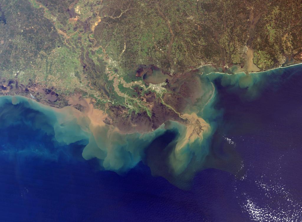
13 Erosion driven by instabilities Intensive deforestation in the watershed => erosion => Terrigenous flux to margin Part played by vegetation panache de sédiments terrigènes Zone déboisée = érosion Couverture initiale NASA 13
14 Climate periodicities control on erosion dry time Precipitations arid Vegetation Erodability Sediment Production Climate change max min max min max min erosion Punctuated clastic production from Knox,

15 Integrated study of passive margins «!source-to-sink!» Watershed - depocentre relationship Angola: thick and focused deposits extensive continental watershed Africa SW: distributed and thin deposits little continental erosion Oligocene-Present isopachs 4.5km km Rust & Summerfield 1990, Anka 2004 Congo deep-sea-fan Congo Orange 15

16 Long-term evolution of W. Africa deep-sea fans Congo-Angola: Cenozoic deep-sea-fan 0km 5km 10km synrift Cont. crust Oceanic crust 50km South-Africa : late Cretaceous margin + deep-sea-fan seamount Oceanic crust Syn-rift+SDR Cont. Cr. 50km Séranne &Anka 2005, 16

17 Onset of Cenozoic deep-sea-fan deposition SW NE Miocene latest 0.5 s Condensed surface 1 km SB Progradation of Tertiary DSF Down lap Base Oligocene Top Turonian On lap salt 17 Tur.
18 ? Rust & Summerfield 1990, Anka 2004, Leturmy & Lucazeau ? Condensed interval

19 terrigeous terrigenous Continental erosion marls carbonates Evaporites Reduced continental erosion terrigenous = syntectonic sedimentation 19

20 Climate change Climate change (icehouse) => increased continental erosion => increase terrigenous flux 20


21 Deep sea fans on mature margins Oceanic crust 0-10Ma 10-25Ma 40-65Ma Ma Ma Terrigenous sediments over oceanic crust Huge depocenter => burial + gravitational deformation Large flux => large watershed, intense erosion Sedimentation rate increase in Neogene Continental crust Lopez, km 21
")

22 Margin Congo Turbidite deep-sea-fan (800 km) Angola ent Escarpem Deep-sea fans : Congo (Lopez, 2000) 22
")
23 Geometry of Congo DSF (Anka, 2004) 23


24 Flexural loading of Amazon DSF Watts,
25 Driscoll & Karner, 1994 Pb: the Amazon DSF cannot be separated from the margin depocenter Sedimentary load = DSF load + margin load 25 Flexural loading of Amazon DSF

26 Effect of Congo DSF on the passive margin Niger fan medio-atlantic ridge Congo fan Congo watershed Sedimentary load => flexure of the oceanic lithosphere Modifié d! après Uchupi,
")
27 Flexural loading of Congo DSF Te=20km (Anka, 2004) 27

28 Interactions Margin-DSF!!DSF sedimentary record complements that of the margin;!!dsf depocentres are as big as margin s depocentre,!!loading increases subsidence in mature margins AND flexural uplift of oshore margin;!!continental drainage concentrates in few major rivers!!dsf record processes active on continent (Seranne Anka, 2005) 28

29 Source-to-sink Yellow River / Bohai Sea NASA 29
Sedimentation on passive margins. Master1 Géologie de l Exploration et des Réservoirs Dynamique des Bassins Michel Séranne
 Sedimentation on passive margins 1 Tectonic-sedimentation relationships at passive margin scale rift Break-up Young margin Sedimentation is controled by continental margin geodynamic evolution Mature margin
South Pyrenean foreland basin
 South Pyrenean foreland basin 1 7 South Pyrenean foreland basin 1 8 South-Pyrenean Foreland basin S N Fore-bulge deformation Piggy-back B. Thrust nappes Basement Vergés & al, 2002 decollement Syntectonic
Meandering Miocene Deep Sea Channel Systems Offshore Congo, West Africa
 Meandering Miocene Deep Sea Channel Systems Offshore Congo, West Africa S. Baer* (PGS), J. E. Comstock (PGS), K. Vrålstad (PGS), R. Borsato (PGS), M. Martin (PGS), J.P. Saba (SNPC), B. Débi-Obambé (SNPC)
Sequence Stratigraphy. Historical Perspective
 Sequence Stratigraphy Historical Perspective Sequence Stratigraphy Sequence Stratigraphy is the subdivision of sedimentary basin fills into genetic packages bounded by unconformities and their correlative
ARTICLE IN PRESS. Received 5 February 2005; accepted 18 July 2005
 Journal of African Earth Sciences xxx (2005) xxx xxx www.elsevier.com/locate/jafrearsci South Atlantic continental margins of Africa: A comparison of the tectonic vs climate interplay on the evolution
SEDIMENTARY BASINS BASIN TYPES ACCORDING TO TECTONIC. by Prof. Dr. Abbas Mansour
 SEDIMENTARY BASINS BASIN TYPES ACCORDING TO TECTONIC by Prof. Dr. Abbas Mansour B. Convergent plate margins 10. STABLE CONTINENTAL INTERIOR BASIN E.g. Lake Eyre Basin Intracratonic (= within stable continental
Sedimentary Basins. Gerhard Einsele. Springer-Verlag Berlin Heidelberg New York London Paris Tokyo Hong Kong Barcelona Budapest
 Gerhard Einsele Sedimentary Basins Evolution, Facies, and Sediment Budget With 269 Figures Springer-Verlag Berlin Heidelberg New York London Paris Tokyo Hong Kong Barcelona Budapest Contents Part I Types
Controls on clastic systems in the Angoche basin, Mozambique: tectonics, contourites and petroleum systems
 P2-2-13 Controls on clastic systems in the Angoche basin, Mozambique: tectonics, contourites and petroleum systems Eva Hollebeek, Olivia Osicki, Duplo Kornpihl Schlumberger, London, UK Introduction Offshore
Figure 1: Location and bathymetry of the study area. Gulf of Guinea. Cameroon. Congo. Gabon. PGS/DGH Gabon MegaSurvey Coverage (35000Km 2 ) Eq.
 Eq.") Deepwater hydrocarbon prospectivity analysis of offshore North and South Gabon Muhammad S Tamannai (*), Thomas Hansen (1), Ron Borsato (1), Jennifer Greenhalgh (1) Martial-Rufin Moussavou (2) & Landry
Deepwater hydrocarbon prospectivity analysis of offshore North and South Gabon Muhammad S Tamannai (*), Thomas Hansen (1), Ron Borsato (1), Jennifer Greenhalgh (1) Martial-Rufin Moussavou (2) & Landry
II CENTRAL & NORTH ATLANTIC CONJUGATE MARGINS CONFERENCE
 http://metododirecto.pt/cm2010 ISBN: 978-989-96923-1-2 Volume VII p. 18-22 II CENTRAL & NORTH ATLANTIC CONJUGATE MARGINS CONFERENCE The Combined Effect of Sedimentation Rate and Salt Tectonics on the Angolan
Paleoceanography II Telluric Effects on Oceanography
 Paleoceanography II Telluric Effects on Oceanography Geological Oceanography OCN 622 Gary McMurtry Telluric Effects Tellus = Earth Distribution of Continents at 100 Ma BP and Present Comparison of Earth
A comparison of structural styles and prospectivity along the Atlantic margin from Senegal to Benin. Peter Conn*, Ian Deighton* & Dario Chisari*
 A comparison of structural styles and prospectivity along the Atlantic margin from Senegal to Benin Overview Peter Conn*, Ian Deighton* & Dario Chisari* * TGS, Millbank House, Surbiton, UK, KT6 6AP The
IV OTHER TYPES OF BASINS
 IV OTHER TYPES OF BASINS 1-Strike-slip basins 2-Cratonic basins 3 Late orogenic basins and more 1 Tectonic setting of strike-slip faulting Woodcock 1986 2 Seismic examples of stike-slip faults «!Flower
Deepwater Hydrocarbon Potentialof Orange Basin, South Africa: An Untested Oil Play
 Deepwater Hydrocarbon Potentialof Orange Basin, South Africa: An Untested Oil Play Soumen Dasgupta*, Moumita Sengupta, Prem Kumar, Biswanath Ghosh, Dr. BNS Naidu anddr. Sudhir Mathur. Cairn India Limited,
Copyright McGraw-Hill Education. All rights reserved. No reproduction or distribution without the prior written consent of McGraw-Hill Education
 Copyright McGraw-Hill Education. All rights reserved. No reproduction or distribution without the prior written consent of McGraw-Hill Education Tibetan Plateau and Himalaya -southern Asia 11.00.a VE 10X
Rocks and the Rock Cycle. Banded Iron Formation
 Rocks and the Rock Cycle Banded Iron Formation Rocks Big rocks into pebbles, Pebbles into sand. I really hold a million, million Rocks here in my hand. Florence Parry Heide How do rocks change? How are
EDIMENTARY BASINS. What is a Sedimentary Basin? by Prof. Dr. Abbas Mansour
 EDIMENTARY BASINS What is a Sedimentary Basin? by Prof. Dr. Abbas Mansour WHAT IS A SEDIMENTARY BASIN? A low area on the Earth s surface relative to surroundings e.g. deep ocean basin (5-10 km deep) e.g.
Basin Analysis. Stra-graphy
 Basin Analysis Stra-graphy Basin Analysis Basin analysis integrates program sedimentological, stra-graphic, and tectonic principals to develop a full understanding of the rocks that fill sedimentary basins.
Continental Landscapes
 Continental Landscapes Landscape influenced by tectonics, climate & differential weathering Most landforms developed within the last 2 million years System moves toward an equilibrium Continental Landscapes
PETROLEUM GEOLOGY AND HYDROCARBON POTENTIAL OFFSHORE URUGUAY. MSc. Bruno Conti October 20 th 2017, London
 PETROLEUM GEOLOGY AND HYDROCARBON POTENTIAL OFFSHORE URUGUAY MSc. Bruno Conti October 20 th 2017, London Tectonic Events Falkland rifting (~175-150 Ma) Upper Jurassic Argentina/Uruguay-Namibia breakup
The Nature of Sedimentary Rocks
 The Nature of Sedimentary Rocks Sedimentary rocks are composed of: Fragments of other rocks Chemical precipitates Organic matter or biochemically produced materials The Nature of Sedimentary Rocks Sedimentary
Neogene Uplift of The Barents Sea
 Neogene Uplift of The Barents Sea W. Fjeldskaar A. Amantov Tectonor/UiS, Stavanger, Norway FORCE seminar April 4, 2013 The project (2010-2012) Funding companies Flat Objective The objective of the work
Depositional Environments. Depositional Environments
 Depositional Environments Geographic area in which sediment is deposited Characterized by a combination of geological process & environmental conditions Depositional Environments Geological processes:
Structural Style and Tectonic Evolution of the Nakhon Basin, Gulf of Thailand
 Structural Style and Tectonic Evolution of the Nakhon Basin, Gulf of Thailand Piyaphong Chenrai Petroleum Geoscience Program, Department of Geology, Faculty of Science, Chulalongkorn University, Bangkok
Architecture des Bassins & Géomatique
 Architecture des Bassins & Géomatique 1- Origine des Bassins Sédimentaires Déformation lithosphérique: forçages internes Sédimentation : forçages externes Importance des Bassins Sédimentaires 2- Cadre
Defining the former elevation and shape of the lithosphere, in particular the elevation of the Earth s surface,
 Isostasy in Move Defining the former elevation and shape of the lithosphere, in particular the elevation of the Earth s surface, is important in the restoration of a model as it aids in reducing uncertainty
 Sedimentary Basin Analysis http://eqsun.geo.arizona.edu/geo5xx/geos517/ Sedimentary basins can be classified based on the type of plate motions (divergent, convergent), type of the lithosphere, distance
Seismic stratigraphy, some examples from Indian Ocean, interpretation of reflection data in interactive mode
 Seismic stratigraphy, some examples from Indian Ocean, interpretation of reflection data in interactive mode K. S. Krishna National Institute of Oceanography, Dona Paula, Goa-403 004. krishna@nio.org Seismic
Aptian/Albian Reservoir Development in the Jeanne d Arc Basin, Offshore Eastern Canada
 Aptian/Albian Reservoir Development in the Jeanne d Arc Basin, Offshore Eastern Canada Jonathan Marshall, Statoil Canada Ltd. Calgary, Alberta, Canada. jomars@statoil.com Introduction: The Jeanne d Arc
MARINE GEOLOGY & GEOGRAPHY
 MARINE GEOLOGY & GEOGRAPHY Bathymetry BATHYMETRY BATHYMETRY THE UNDERWATER EQUIVALENT TO TOPOGRAPHY THE STUDY OF WATER DEPTH A BATHYMETRIC MAP SHOWS FLOOR RELIEF OR TERRAIN AS CONTOUR LINES Bathymetry
Rockall Plateau. OCN 201: Shelf Sediments
 Rockall Plateau OCN 201: Shelf Sediments Classification by Size Classification by Mode of Formation Detrital sediments Transported and deposited as particles Derived from weathering of pre-existing rocks
Development of the Global Environment
 Development of the Global Environment G302: Spring 2004 A course focused on exploration of changes in the Earth system through geological history Simon C. Brassell Geological Sciences simon@indiana.edu
A Tectonostratigraphic History of Orphan Basin, Offshore Newfoundland, Canada
 A Tectonostratigraphic History of Orphan Basin, Offshore Newfoundland, Canada Lynn T. Dafoe*, Charlotte E. Keen, Graham L. Williams, and Sonya A. Dehler, Geological Survey of Canada, Dartmouth, NS Canada
Last Time. Submarine Canyons and Fans. Turbidites. MAS 603: Geological Oceanography. Lecture 16: Greenhouse vs. Icehouse Earths
 UNIVERSITY OF SOUTH ALABAMA Last Time MAS 603: Geological Oceanography Lecture 16: Greenhouse vs. Icehouse Earths Submarine Fans Definition and morphology Transport mechanisms (density currents) Submarine
Figure 1 Extensional and Transform Fault Interaction, Influence on the Upper Cretaceous Hydrocarbon System, Equatorial Margin, West Africa.
 Figure 1 Extensional and Transform Fault Interaction, Influence on the Upper Cretaceous Hydrocarbon System, Equatorial Margin, West Africa. Presented to the 10th PESGB/HGS Conference on Africa E + P September
Sediment and sedimentary rocks Sediment
 Sediment and sedimentary rocks Sediment From sediments to sedimentary rocks (transportation, deposition, preservation and lithification) Types of sedimentary rocks (clastic, chemical and organic) Sedimentary
Orphan Basin, Offshore Newfoundland: New seismic data and hydrocarbon plays for a dormant Frontier Basin
 Orphan Basin, Offshore Newfoundland: New seismic data and hydrocarbon plays for a dormant Frontier Basin Jerry Smee* G&G Exploration Consulting, 301 400-3rd Avenue SW, Calgary, AB, T2P 4H2 Sam Nader, Paul
Plate Tectonics GEOL 101 Lecture 22 How Are Mountains Built?
 Plate Tectonics GEOL 101 Lecture 22 How Are Mountains Built? The Grand Tetons, Wyoming First a Brief Review of Sea Floor Spreading Prop: Test 3 Invitations Break-Up of a Continent and Origin of an Ocean
Figure 1. Examples of vector displacement diagrams for two and three-plate systems.
 Figure 1. Examples of vector displacement diagrams for two and three-plate systems. Figure 2. Relationships between pole of rotation, great circles, ridge segments, small circles, transforms and fracture
Objectives: Define Relative Age, Absolute Age
 S6E5. Students will investigate the scientific view of how the earth s surface is formed. c. Classify rocks by their process of formation. g. Describe how fossils show evidence of the changing surface
Sedimentary Cycle Best Practice: Potential Eo-Oligocene Sediments in Western Indonesia*
 Sedimentary Cycle Best Practice: Potential Eo-Oligocene Sediments in Western Indonesia* Mellinda Arisandy 1 and I Wayan Darma 1 Search and Discovery Article #11008 (2017)** Posted November 6, 2017 *Adapted
Beckenanalyse 2. Genetische stratigraphische Konzepte
 Beckenanalyse 2. Genetische stratigraphische Konzepte Einsele 2000 CYCLIC BEDDING Einsele 2000 1 Sequenzstratigraphie Das Konzept der Sequenzstratigraphie beruht auf dem Zusammenspiel von Sedimentzufuhr
Understanding Earth Fifth Edition
 Understanding Earth Fifth Edition Grotzinger Jordan Press Siever Chapter 5: SEDIMENTATION: Rocks Formed by Surface Processes Lecturer: H Mohammadzadeh Assistant professors, Department of Geology, FUM Copyright
Cenozoic: Global Events Ma- Present
 Cenozoic: Global Events 65.5 Ma- Present Major Tectonic Events The Rise of the Himalayas and Closure of the Tethyan Ocean Caused Climate Change Equatorial Ocean Closed Rifting in Western North America
Movement of the Earth s Crust: Formation of: Mountain s Plateau's and Dome s
 Movement of the Earth s Crust: Formation of: Mountain s Plateau's and Dome s References Information taken from several places including Prentice Hall Earth Science: @ http://www.eram.k12.ny.us/education/components/docmgr/default.php?sectiondetaili
Chapter 10: Deformation and Mountain Building. Fig. 10.1
 Chapter 10: Deformation and Mountain Building Fig. 10.1 OBJECTIVES Describe the processes of rock deformation and compare and contrast ductile and brittle behavior in rocks. Explain how strike and dip
IV OTHER TYPES OF BASINS
 IV OTHER TYPES OF BASINS - Strike-slip basins - Aulacogens - Cratonic basins Late orogenic basins and more Master Réservoirs Géologiques Dynamique des Bassins - Michel Séranne - Strike-slip Basins Tectonic
Perspectives from Offshore Argentina & Uruguay
 Perspectives from Offshore Argentina & Uruguay A Prospectivity Overview Hannah Kearns October 2018 Introduction Argentina Offshore License Round 1 14 blocks Argentina North, 24 Austral-Malvinas Offshore
Reconnaissance study of the ancient Zaire (Congo) deep-sea fan (ZaiAngo Project)
 deep-sea fan (ZaiAngo Project)") Marine Geology 209 (2004) 223 244 www.elsevier.com/locate/margeo Reconnaissance study of the ancient Zaire (Congo) deep-sea fan (ZaiAngo Project) Zahie Anka, Michel Séranne* Laboratoire Dynamique de la
Marine Geology 209 (2004) 223 244 www.elsevier.com/locate/margeo Reconnaissance study of the ancient Zaire (Congo) deep-sea fan (ZaiAngo Project) Zahie Anka, Michel Séranne* Laboratoire Dynamique de la
DATA ANALYSIS AND INTERPRETATION
 III. DATA ANALYSIS AND INTERPRETATION 3.1. Rift Geometry Identification Based on recent analysis of modern and ancient rifts, many previous workers concluded that the basic structural unit of continental
USU 1360 TECTONICS / PROCESSES
 USU 1360 TECTONICS / PROCESSES Observe the world map and each enlargement Pacific Northwest Tibet South America Japan 03.00.a1 South Atlantic Arabian Peninsula Observe features near the Pacific Northwest
Earth Science, (Tarbuck/Lutgens) Chapter 10: Mountain Building
 Chapter 10: Mountain Building") Earth Science, (Tarbuck/Lutgens) Chapter 10: Mountain Building 1) A(n) fault has little or no vertical movements of the two blocks. A) stick slip B) oblique slip C) strike slip D) dip slip 2) In a(n) fault,
Earth Science, (Tarbuck/Lutgens) Chapter 10: Mountain Building 1) A(n) fault has little or no vertical movements of the two blocks. A) stick slip B) oblique slip C) strike slip D) dip slip 2) In a(n) fault,
Earth Systems Science Chapter 7. Earth Systems Science Chapter 7 11/11/2010. Seismology: study of earthquakes and related phenomena
 Earth Systems Science Chapter 7 I. Structure of the Earth II. Plate Tectonics The solid part of the earth system includes processes, just like the atmosphere and oceans. However, the time scales for processes
Carboniferous Stoddart Group: An integrated approach
 Carboniferous Stoddart Group: An integrated approach Abu Yousuf*, Department of Geoscience, University of Calgary, Calgary, Alberta yousufabu@hotmail.com and Charles M. Henderson, Department of Geoscience,
Depositional Sequences Sequences
 Depositional Sequences Transgressive and Regressive packages can be bound by unconformities Because sediment can only be preserved during net aggradation and progradation All other times there is either
A) B) C) D) 4. Which diagram below best represents the pattern of magnetic orientation in the seafloor on the west (left) side of the ocean ridge?
 B) C) D) 4. Which diagram below best represents the pattern of magnetic orientation in the seafloor on the west (left) side of the ocean ridge?") 1. Crustal formation, which may cause the widening of an ocean, is most likely occurring at the boundary between the A) African Plate and the Eurasian Plate B) Pacific Plate and the Philippine Plate C)
1. Crustal formation, which may cause the widening of an ocean, is most likely occurring at the boundary between the A) African Plate and the Eurasian Plate B) Pacific Plate and the Philippine Plate C)
The Late Tertiary Deep-Water Siliciclastic System of the Levant Margin - An Emerging Play Offshore Israel*
 The Late Tertiary Deep-Water Siliciclastic System of the Levant Margin - An Emerging Play Offshore Israel* Michael A. Gardosh 1, Yehezkel Druckman 2 and Binyamin Buchbinder 2 Search and Discovery Article
Seismic interpretation. Principles of seismic stratigraphic interpretation
 Seismic interpretation Principles of seismic stratigraphic interpretation Seismic interpretation Seismic stratigraphy is a technical for interpreting stratigraphic information from seismic data. The resolution
The thermal and density structure of passive margins
 The thermal and density structure of passive margins Magdalena Scheck-Wenderoth, Yuriy Maystrenko, Julia Autin, Hans Jürgen Götze, Sabine Schmidt, Christian Reichert basins in their plate-tectonic setting
TRIASIC RUPTURE AND LIASIC MARINE INVASION IN THE LUSITANIAN BASIN (PORTUGAL) A SHIFT FROM TECTONIC TO THERMAL SUBSIDENCE
 A SHIFT FROM TECTONIC TO THERMAL SUBSIDENCE") TRIASIC RUPTURE AND LIASIC MARINE INVASION IN THE LUSITANIAN BASIN (PORTUGAL) A SHIFT FROM TECTONIC TO THERMAL SUBSIDENCE R.P. PENA dos REIS (1), N.L.V. PIMENTEL (2) & A.J.V. GARCIA (3) ATLANTIS (1) D.C.T.,
TRIASIC RUPTURE AND LIASIC MARINE INVASION IN THE LUSITANIAN BASIN (PORTUGAL) A SHIFT FROM TECTONIC TO THERMAL SUBSIDENCE R.P. PENA dos REIS (1), N.L.V. PIMENTEL (2) & A.J.V. GARCIA (3) ATLANTIS (1) D.C.T.,
Kilometre-Scale Uplift of the Early Cretaceous Rift Section, Camamu Basin, Offshore North-East Brazil*
 Kilometre-Scale Uplift of the Early Cretaceous Rift Section, Camamu Basin, Offshore North-East Brazil* Iain Scotchman 1 and Dario Chiossi 2 Search and Discovery Article #50183 (2009) Posted May 20, 2009
Geologic Structures. Changes in the shape and/or orientation of rocks in response to applied stress
 Geologic Structures Changes in the shape and/or orientation of rocks in response to applied stress Figure 15.19 Can be as big as a breadbox Or much bigger than a breadbox Three basic types Fractures >>>
SUPPLEMENTARY INFORMATION
 SUPPLEMENTARY INFORMATION Miocene drainage reversal of the Amazon River driven by plate-mantle interaction. Shephard, G.E., Müller, R.D., Liu, L., Gurnis, M. Supplementary Figures SOM Figure 1. Non-dimensional
Chatham Rise Phosphorite. Observations from the literature
 Chatham Rise Phosphorite Observations from the literature Content 1. Where is it? 2. Why is it there? i. Stratigraphy ii. Structure iii. GONDWANA iv. Ocean circulation v. Ocean fronts 3. The answer...
Mesozoic Earth History
 Mesozoic Earth History The Mesozoic Era 251-66 MYA Breakup of Pangea Changes in air and oceanic currents Evolution of new terrestrial and marine life Opening of the Atlantic Ocean Basin Rocky Mountains
Chapter 9 Lecture Outline. Oceans: The Last Frontier
 Chapter 9 Lecture Outline Oceans: The Last Frontier The Vast World Ocean Earth is referred to as the blue planet 71% of Earth s surface is oceans and marginal seas Continents and islands comprise the remaining
Crustal Activity. Plate Tectonics - Plates - Lithosphere - Asthenosphere - Earth s surface consists of a major plates and some minor ones
 Name: Date: Period: Tectonics The Physical Setting: Earth Science CLASS NOTES Tectonics - s - Lithosphere - Asthenosphere - Earth s surface consists of a major plates and some minor ones The plates are
GLY 155 Introduction to Physical Geology, W. Altermann. Press & Siever, compressive forces. Compressive forces cause folding and faulting.
 Press & Siever, 1995 compressive forces Compressive forces cause folding and faulting. faults 1 Uplift is followed by erosion, which creates new horizontal surface. lava flows Volcanic eruptions cover
Foundations of Earth Science, 6e Lutgens, Tarbuck, & Tasa
 Foundations of Earth Science, 6e Lutgens, Tarbuck, & Tasa Oceans: The Last Frontier Foundations, 6e - Chapter 9 Stan Hatfield Southwestern Illinois College The vast world ocean Earth is often referred
Outline 23: The Ice Ages-Cenozoic Climatic History
 Outline 23: The Ice Ages-Cenozoic Climatic History Continental Glacier in Antarctica Valley Glaciers in Alaska, note the moraines Valley Glaciers in Alaska, note the moraines Mendenhall Glacier, Juneau,
The Sierra Leone-Liberia Emerging Deepwater Province*
 The Sierra Leone-Liberia Emerging Deepwater Province* Joan F. Flinch 1, José L. Huedo 1, Hernán Verzi 1, Héctor González 1, Ricardo Gerster 1, Abdul K. Mansaray 1, L. P. Painuly 1, Leticia Rodriguez-Blanco
Biostratigraphic and Lithostratigraphic Correlation of Sedimentary Strata in the Atlantic Coastal Plain
 Biostratigraphic and Lithostratigraphic Correlation of Sedimentary Strata in the Atlantic Coastal Plain Introduction to the Atlantic Coastal Plain (Please read this page prior to doing the lab) The Atlantic
Plaattektoniek en Mickey Mouse: de bewegingen van de Aarde en de geologie van Marokko. G. Bertotti - TUDelft
 Plaattektoniek en Mickey Mouse: de bewegingen van de Aarde en de geologie van Marokko G. Bertotti - TUDelft Moving continents Continent with matching boundaries Same fauna in different continents Similar
The Ocean Floor Earth Science, 13e Chapter 13
 The Ocean Floor Earth Science, 13e Chapter 13 Stanley C. Hatfield Southwestern Illinois College The vast world ocean Earth is often referred to as the blue planet Seventy-one percent of Earth s surface
Lecture 18 Paleoceanography 2
 Lecture 18 Paleoceanography 2 May 26, 2010 Trend and Events Climatic evolution in Tertiary Overall drop of sea level General cooling (Figure 9-11) High latitude (deep-water) feature Two major step Middle
Quiz 12 Bonus 2 (9:30-9:35 AM)
") Quiz 12 Bonus 2 (9:30-9:35 AM) UNIVERSITY OF SOUTH ALABAMA GY 112: Earth History Lectures 32 and 33: Mesozoic Sedimentation Instructor: Dr. Douglas W. Haywick Last Time Mesozoic Tectonics A) The Triassic
Quiz 12 Bonus 2 (9:30-9:35 AM) UNIVERSITY OF SOUTH ALABAMA GY 112: Earth History Lectures 32 and 33: Mesozoic Sedimentation Instructor: Dr. Douglas W. Haywick Last Time Mesozoic Tectonics A) The Triassic
MARINE GEOLOGY & GEOGRAPHY
 MARINE GEOLOGY MARINE GEOLOGY & GEOGRAPHY Marine Geology 4 LAYERS OF THE EARTH CRUST THICKNESS: VARIES BETWEEN OCEAN & CONTINENTS 5-40 KM STATE: SOLID ELEMENTS: SILICON, ALUMINUM, CALCIUM, SODIUM, POTASSIUM
Answers: Internal Processes and Structures (Isostasy)
") Answers: Internal Processes and Structures (Isostasy) 1. Analyse the adjustment of the crust to changes in loads associated with volcanism, mountain building, erosion, and glaciation by using the concept
Answers: Internal Processes and Structures (Isostasy) 1. Analyse the adjustment of the crust to changes in loads associated with volcanism, mountain building, erosion, and glaciation by using the concept
When last we left off. Western Cordillera NA. Cretaceous. Cretaceous, continued. Cretaceous to present
 When last we left off Western Cordillera NA Cretaceous to present Wild and weird things happened in the murky past of the Archean and precambrian Cambrian through Devonian development of deep water sediments
Summary. The Ice Ages and Global Climate
 The Ice Ages and Global Climate Summary Earth s climate system involves the atmosphere, hydrosphere, lithosphere, and biosphere. Changes affecting it operate on time scales ranging from decades to millions
Seismic interpretation of carbonate turbidites in Central Luconia
 GeoL. Soc. MaLayaia, BuLLetin 47, December 2005; pp. 77-85 Seismic interpretation of carbonate turbidites in Central Luconia FRANcis Ho, GUENTER JAEGER AND PmT LAMBREGTS Sarawak Shell Berhad SMEP Exploration
Section 2: How Mountains Form
 Section 2: How Mountains Form Preview Objectives Mountain Ranges and Systems Plate Tectonics and Mountains Types of Mountains Objectives Identify the types of plate collisions that form mountains. Identify
Lab 7: Sedimentary Structures
 Name: Lab 7: Sedimentary Structures Sedimentary rocks account for a negligibly small fraction of Earth s mass, yet they are commonly encountered because the processes that form them are ubiquitous in the
Plate Tectonics. entirely rock both and rock
 Plate Tectonics I. Tectonics A. Tectonic Forces are forces generated from within Earth causing rock to become. B. 1. The study of the origin and arrangement of Earth surface including mountain belts, continents,
Continental Margin Geology of Korea : Review and constraints on the opening of the East Sea (Japan Sea)
") Continental Margin Geology of Korea : Review and constraints on the opening of the East Sea (Japan Sea) Han-Joon Kim Marine Satellite & Observation Tech. Korea Ocean Research and Development Institute
Continental Margin Geology of Korea : Review and constraints on the opening of the East Sea (Japan Sea) Han-Joon Kim Marine Satellite & Observation Tech. Korea Ocean Research and Development Institute
Thermal Subsidence Tool in Move
 Thermal Subsidence Tool in Move During the formation of rift basins, the continental crust is stretched and thinned. As it thins, the asthenosphere rises to fill the space created by the thinned continental
OCN 201 Physiography of the Seafloor
 OCN 201 Physiography of the Seafloor Hypsometric Curve for Earth s solid surface Note histogram Hypsometric curve of Earth shows two modes. Hypsometric curve of Venus shows only one! Why? Ocean Depth vs.
Marine Cenozoic Record. Precambrian - Jurassic. Uplift. Compton (2004) Thin Cenozoic cover on the margin. Orange Basin. SA Petroleum Agency
 Thin Cenozoic cover on the margin. Orange Basin. SA Petroleum Agency") Marine Cenozoic Record Precambrian - Jurassic A B Uplift Thin Cenozoic cover on the margin Compton (2004) Orange Basin SA Petroleum Agency Eustatic Sea Level (m) 250 200 150 100 50 0 Quat Pliocene AGE
Marine Cenozoic Record Precambrian - Jurassic A B Uplift Thin Cenozoic cover on the margin Compton (2004) Orange Basin SA Petroleum Agency Eustatic Sea Level (m) 250 200 150 100 50 0 Quat Pliocene AGE
Plio-Pleistocene Geology
 UNIVERSITY OF SOUTH ALABAMA GY 112: Earth History Plio-Pleistocene Geology Instructor: Dr. Douglas W. Haywick Last Time A) Cenozoic Tectonics Western North American tectonic provinces Plateaus and canyons
Earthquakes. Earthquakes are caused by a sudden release of energy
 Earthquakes Earthquakes are caused by a sudden release of energy The amount of energy released determines the magnitude of the earthquake Seismic waves carry the energy away from its origin Fig. 18.1 Origin
Geology (Mellow) Hike, Santa Lucia Memorial Park February 16, I. Overview of Santa Lucia Range geology and tectonic history
 Hike, Santa Lucia Memorial Park February 16, I. Overview of Santa Lucia Range geology and tectonic history") Geology (Mellow) Hike, Santa Lucia Memorial Park February 16, 2015 I. Overview of Santa Lucia Range geology and tectonic history A. Basement Rocks 1. Salinian Block Rocks Sierra Nevada Type, continental
Geology (Mellow) Hike, Santa Lucia Memorial Park February 16, 2015 I. Overview of Santa Lucia Range geology and tectonic history A. Basement Rocks 1. Salinian Block Rocks Sierra Nevada Type, continental
OCN 201 Physiography of the Seafloor
 OCN 201 Physiography of the Seafloor 1 Ocean Depth versus Continental Height Why do we have dry land? Solid surface of Earth is dominated by two levels: Land with a mean elevation of +840 m (29% of Earth
Depositional History and Petroleum Potential of Ombilin Basin, West Sumatra - Indonesia, Based on Surface Geological Data*
 Depositional History and Petroleum Potential of Ombilin Basin, West Sumatra - Indonesia, Based on Surface Geological Data* Yahdi Zaim 1, Litto Habrianta 2, Chalid I. Abdullah 1, Aswan 1, Yan Rizal 1, Nurcahyo
The boundary between two formations (or any distinct layers) is called a contact. Sedimentary rocks cover 75% of continents.
 is called a contact. Sedimentary rocks cover 75% of continents.") Sedimentary Rocks Sedimentary rocks form at the Earth s surface through interactions of the hydrologic system and the crust. Fortunately, many of these processes are in operation today, and geologists
Sedimentary Rocks Sedimentary rocks form at the Earth s surface through interactions of the hydrologic system and the crust. Fortunately, many of these processes are in operation today, and geologists
Luderitz Basin, Offshore Namibia: Farm-out Opportunity. APPEX, London, March 2015 Graham Pritchard, Serica Energy plc
 Luderitz Basin, Offshore Namibia: Farm-out Opportunity APPEX, London, March 2015 Graham Pritchard, Serica Energy plc Serica Luderitz Basin Namibia Introduction Serica (85%, operator) 17,384 km 2 acreage
F.H. NADER 1, PETROLEUM SYSTEMS MODELING CHALLENGES OF STRUCTURALLY COMPLEX FRONTIER BASINS: THE CASE OF THE LEVANT (EAST-MED) BASIN
 BASIN") PETROLEUM SYSTEMS MODELING CHALLENGES OF STRUCTURALLY COMPLEX FRONTIER BASINS: THE CASE OF THE LEVANT (EAST-MED) BASIN A PROPOSED INTEGRATED APPROACH F.H. NADER 1, J. Barabasch 2, L. Inati 1, M. Ducros
PETROLEUM SYSTEMS MODELING CHALLENGES OF STRUCTURALLY COMPLEX FRONTIER BASINS: THE CASE OF THE LEVANT (EAST-MED) BASIN A PROPOSED INTEGRATED APPROACH F.H. NADER 1, J. Barabasch 2, L. Inati 1, M. Ducros
Supplementary Material for Eighty million years of folding migration: new perspective on the Syrian Arc from Levant basin analysis
 GSA Data Repository 2018040 https://doi.org/10.1130/g39654.1 Supplementary Material for Eighty million years of folding migration: new perspective on the Syrian Arc from Levant basin analysis Sagy Yael,
Section 1: How Did Life Begin? Chapter 19: History of Life on Earth. Section 2: The Age of Earth
 Chapter 19: History of Life on Earth Section 1: How Did Life Begin? I. The Basic Chemicals of Life A. 1920s B. Earth s early oceans contained large amounts of organic molecules C. Molecules formed spontaneously
Oceanography, An Invitation to Marine Science 9e Tom Garrison. Ocean Basins Cengage Learning. All Rights Reserved.
 Oceanography, An Invitation to Marine Science 9e Tom Garrison 4 Ocean Basins Key Concepts Tectonic forces shape the seabed The ocean floor is divided into continental margins and deep ocean basins The
Geosphere Final Exam Study Guide
 Geosphere Final Exam Study Guide Chapter 1 Intro to Earth Systems 1. Name and describe Earth s 4 major spheres Geosphere-- nonliving, mostly solid rock divided into crust, mantle, and core Atmosphere a