A delta is a depositional system developed where a river enters a standing water body (sea or lake). Different features will characterize deltas
|
|
|
- Melinda Hester Warren
- 5 years ago
- Views:
Transcription

1 DELTAIC SYSTEMS
.")

2 A delta is a depositional system developed where a river enters a standing water body (sea or lake). Different features will characterize deltas formed under different wave or tidal influence, sediment supply and coastal morphology. after Dalrymple et al., 1992


3 The name Greek letter
4 Factors in Delta Development 1. Climate 2. Water discharge 3. Sediment yield 4. River-mouth processes 5. Wave power 6. Tidal processes 7. Aeolian processes 8. Nearshore currents 9. Shelf slope 10. Tectonics of receiving basin 11. Receiving basin geometry

5 Different types of Deltas
6 Processes Important in Delta Development and Maintenance CLIMATE Controls sediment-water yield. Controls in-situ delta deposits. Tropical = large thick accumula=ons of peat. Temperate = thin, high con=nuous peat layers. Arid = complex interfingering of supra=dal and evaporite deposits.
7 Processes Important in Delta Development and Maintenance WATER DISCHARGE 1. ERRATIC DISCHARGE = braided channels with wide lateral con=nuity. Numerous interfingering, fining upward sequences showing highly variable porositypermeability rela=onships. v. irregular sedimenta=on rates. 2. NON-ERRATIC DISCHARGE = stable meandering channels (shoestringing sands).
8 Processes Important in Delta Development and Maintenance SEDIMENT YIELD 1. Primarily func=on of basin area and discharge. 2. High fine grained sediment loads = expansive sub-aqueous deltas with high H 2 O content and unstable clays. Slumping Deforma=onal features Local diapirism 3. Compac=on is high.
 into form a lobate body.")
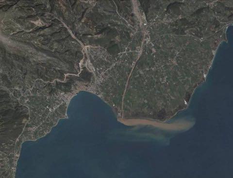
9 Processes Important in Delta Development and Maintenance RIVER MOUTH PROCESSES Where a distributary channel enters a water body, most of its sedimentary load is dropped down and redistributed by the overriding sustained flow (tractional conditions) into form a lobate body. After dropping sediment, the riverine-fed flow decreases its density (ρf ), which can be higher, similar or lower than those of the surrounding water (ρw). If ρf<ρw, the flow will override the main water body forming a plume (hypopycnal flow). If ρf~ρw, the flow will mix rapidly with the main water body (homopycnal flow). If ρf>ρw, the flow will glide down under the main water body (hyperpycnal flow). If at a certain depth hyperpycnal flows meet a denser watermass (stratified water bodies), these cases the flow will detach itself from the floor and override the denser water (mesopycnal flow). After Galloway & Hobday, 1996

10

11
12 Processes Important in Delta Development and Maintenance Waves Most important in reshaping deltas. Volume sediment delivered/wave energy. Deposi=onal units = beaches, barriers, etc. Low energy = low profile beaches osen overwash dominated. High energy = higher profiles with high quartz deposits. Subaqueous slope - auenua=on capacity. Low energy 1 x 10 7 ergs/second High energy 20 x 10 7 ergs/second
13 Processes Important in Delta Development and Maintenance Tidal Processes 1. Reduc=on in ver=cal density stra=fica=on, therefore buoyancy insignificant. 2. Bidirec=onal sediment transport (flood and ebb). 3. Marine and fluvial mixing zone is expansive (ver=cal and horizontal). Linear =dal ridges common. Upstream =dal asymmetry resul=ng in significant bedload transport into system.
14 Processes Important in Delta Development and Maintenance Winds Can create wind set-up at coast giving rise to current and liuoral circula=on. Can create significant increases in nearshore wave energy. Offshore winds can cause set-down and therefore reduce wave ac=on significantly. Parallel-to-coast winds can drive longshore currents resul=ng in significant mud deposits downdris of delta.
15 Processes Important in Delta Development and Maintenance Nearshore Currents Driven by: Deep oceanic currents impinging on shelf. Tidal propaga=on. Wind and water. Density currents. Offshore sandbodies sub-parallel/parallel to deposi=onal strike. Sand bodies located significant distances offshore or downdris form ac=ve lobe.
16 Processes Important in Delta Development and Maintenance Shelf Slope High rates of sediment accumula=on and rapid prograda=on resul=ng in low angle slopes. Fric=onal auenua=on of surface gravity waves. Slopes may be ac=vely prograding during modern =me. Submarine canyons = net loss of sediment (Congo, Ganges- Brahmaputra).
17 Processes Important in Delta Development and Maintenance Tectonics of Receiving Basin Rapidly subsiding basins result in overthickening of deltaic bodies. Rela=vely stable result in con=nuous, widespread, laterally con=nuous bodies. Localized differen=al weigh=ng and dewatering of sediments = Subaqueous mass movement. Displaced sediments. Complex slumping.
. III. Downwarped area-sediment movement inland (Niger). IV. Ac=ve subsidence seaward of shoreline (Senegal River). V.")
18 Processes Important in Delta Development and Maintenance Major ConfiguraBons of Receiving Basins I. Skewed deltas due to high current (Sea of Japan). II. Input of sediment from closed end (Gulf of California). III. Downwarped area-sediment movement inland (Niger). IV. Ac=ve subsidence seaward of shoreline (Senegal River). V. Semi-enclosed (Gulf of Mexico).

19 Distributary Channel PaEerns A. High subsidence, low waves & offshore slope, small tidal range, fine grained sediments B. Erratic discharge, intermediate wave energy, high tide range, steep offshore slope C. High waves, high tidal range

20 Types of Delta Switching PaEerns


21 Main types Mississipi Delta: fluvial dominated Rodano Delta: wave dominated Gange Delta: tide dominated

 and a prodelta (where fine deposits are accumulated over a")
22 Components of a Delta environment After Bhattacharya, 2006 Despite all the possible variations, the basic architecture of a deltaic body shows a delta-plain area (characterized by the presence of distributary channels), a delta front (the steepest part of the system) and a prodelta (where fine deposits are accumulated over a sub-horizontal surface.
 and shoal-water type delta,")
23 Postma s classification (1990) is based on feeder systems and water depth at river mouth. This last parameter allow to define two main typologies of deltas: Gilbert-type delta, with a steep front (25-35 ) and shoal-water type delta, with a gently inclined front (5-15 ) after Postma, 1990


24 Independently from water depth or dominant sedimentary processes, the basic building block of the deltaic architecture will be a lobate accumulation developed at the outlet of the distributary channel and called mouth bars.

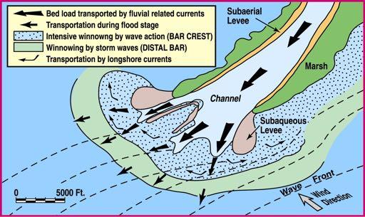
25 Deposi=onal Environments at a River Mouth
. Modified after Wellner et al.")
26 Lateral and vertical stacking of mouth-bar units will build up the deltaic body forming a lobate front which will be reshaped by other processes (tides or waves). Modified after Wellner et al., 2005

27 In SHALLOW WATER SETTING, the abrupt flow expansion lead to a sediment dropping at a very high rate, commonly promoting formation of massive, normal-graded deposits, which can be successively removed under tractional/ frictional condition by the overriding sustained flow. after Wellner et al., 2005
28 A mouth bar is commonly fan-shaped, with a flat base and concave upward top. Beds thins both laterally and frontally. The proximal part is commonly characterized by erosive surfaces, indicating a dominant bypass. Feeder-channel levee can be present also underwater in the proximal mouth-bar area. Sedimentary features of mouth bars are mainly defined in shallow-water settings. after Bridge & Demicco, 2008

29 Sedimentary dynamics and deposits in a mouth bar are very similar to those characterizing a crevasse splay in alluvial plain setting. after Fielding, 2010

30 Although, the basic architecture of a mouth-bar lobe is simple, several minor feature can testify the occurrence of peculiar processes of sediment distribution. after Fidolini, 2010

31 In the proximal part of the bar, the coarser fraction occur. The bar front can be inclined up to 15 and massive, normalgraded beds can be accumulated by rapid sediment dumping from turbulent suspensions. after Fidolini, 2010

32 In the proximal part of the bar, sections transverse to the main flow show a mounded geometry of the bar after Fidolini, 2010

33 In the proximal part of the bar, sections transverse to the main flow can also show the geometry of the feeder channel.

34 In the distal part of the bar, fine-grained deposits and tabular geometries will be dominant. Localized scours can also occur. after Fidolini, 2010


35 CU Mouth bar progradation will form coarsening-upward units, from mud and fine sand (distal lobe) to coarse sand and gravels, if the feeder channel is preserved at the top. CU

36 CU
37 Sections parallel to flow will show gently inclined beds (3-10 ) pinching out downcurrent. CU

38 Spatial distribution of deltaic mouth bars is commonly controlled the attitude of the system to fill the available spaces. Normally, a newly prograding bar will tend to fill the space between two pre-existing lobes. The stratal architecture derived from this process is called compensational stacking pattern, and, in outcrops, it will be highlighted by stacked bed packages pinching out toward different directions. B A A B

39 mouth bar3 mouth bar2 mouth bar1
40

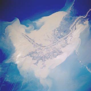
41 In case of fluvial-dominated deltas, mouth bar can prograde for long distances from the coast generating deltas with digitated profile. In these cases mouth bar are labeled as finger-bar. after Reineck, 1970

42

43 Finger bars progrades over fine sediments, which are commonly intensively loaded. The presence of well-developed channel levee, limits sediment dispersion in the interlobe areas, which are commonly characterized by mud deposition. after Fisk, 1970

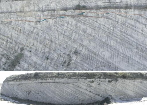
44 Where distributary channels will enter relatively deep water, a different type of mouth-bar will develop. Lateral stacking of these mouth-bars will produce a GILBERT-TYPE DELTA. Gilbert deltas are characterized by the presence of an avalanching front. Basin on their architecture, they are divided into four main portions (from base to top): topset, foreset, toeset and bottomset. It s clear that the difference in elevation between topset and bottomset represents the depth of the waterbody where the delta is prograding. toeset topset foreset bottomset


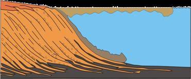
45 TOPSET (tracbon) FORESET (en-mass+tracbon) TOESET (tracbon+en-mass) BOTTOMSET (tracbon) 5 m 500 m
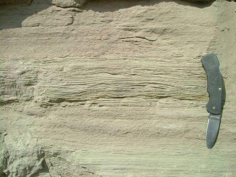
46

47 TOPSET FORESET TOESET

48 FORESET TOPSET

49 Topset/foreset transition Topset deposits are commonly represented by fluvial deposits (with different styles) which can be locally strongly reworked by waves or tidal currents. According to some Authors, gradual transitions between topset and foreset deposits can be indicative of wave influence. Abrupt transitions can be indicative of fluvial dominance. TOPSET FORESET

50 A gradual transition is thought to be indicative of wave reworking.

51 These geometries can also be interpreted in terms of base level oscillations
52

53 Foresets are characterized by a depositional angle ranging between 25 and 30, but they can reach 40 if the sediment is sufficiently coarse. Under these conditions, delta front is unstable and commonly affected by collapses, which can generate slumps, debris flow or even turbidity currents. These processes commonly form linguoid accumulations along the front, where also erosive features (scours or chute cut by currents accelerating along the slope) can be present. after Nemec, 1990

54 Foreset deposits in transverse sections, can locally highlight the mounded geometry of gilbertian, mouth-bar lobes.


55 Lateral shift of gilbertian mouth bars is commonly highlighted by backlap and downlap geometries in parallel sections. DOWNLAP BACKLAP BACKLAP DOWNLAP

56 A peculiar feature of Gilbert deltas is represented by the so called «backset beds», whose development is associated with hydraulic jump conditions.
57 Debris flow Debris flow Debris flow Hydraulic jump occur commonly where the flow expands colliding with an obstacle, which is commonly represented by a debris-flow accumulation. Debris flow

58

59 Toeset deposits represent the transition between the steeply inclined foreset and the subhorizontal bottomset. Because of the significant change in depositional angle, the larger rolling clasts along with several debris flow are trapped in the toeset zone, where also turbulent flows can drop part of their sedimentary load.

60
, although, being located (such as toeset) below")
61 Bottomset are the finest deposits of the Gilbertian system. They are characterized by deposition of turbidity currents (HDTC and LDTC), although, being located (such as toeset) below the wave base, they are commonly interested also by mud settling.
62


63 Sedimentary processes acting in a Gilbert-type delta settins: a summary
64 ORIGIN A OF A GILBERT- TYPE DELTA A deep water setting is required to develop a Gilbert-type delta. Such a conditions can be generated by tectonics (faults) or erosional morphologies. In case of deltas developed on tectonically active escarpments, a different stacking pattern will characterized deltas developed under different extensional regimes from those formed under compressional ones. Normal fault Erosive generated depression Inverse fault


65 Both Gilbert and shoalwater deltas can be dominated by fluvial, tidal or wave processes, but the stratigraphic record of their progradation will be represented by CU successions. after Nichols, 1996


66 WAVE DOMINATED FLUVIAL DOMINATED TIDE DOMINATED da Nichols, 1996

67 Deltas represent probably the major oil and gas reservoirs, and knowledge of their internal architecture is a key point to approach reservoirs. The basic facies models concerning distinction between tide-, wave- and river-dominated deltas are not enough to predict internal architecture and distribution of barriers. Distribution of these properties vary with delta s depositional history, but also with minor local factors, such as topography, sediment supply and depositional processes. Wells placement and reservoir management can be properly assessed only after setting up a detailed facies model for the specific case of study. After Maguregui & Tyler, 1991
68 AKNOWLEDGEMENTS Part of the material contained in this lecture is courtesy of Dr. M. Ghinassi Course on Sedimentology Padova University (Italy) Petroleum Geoscience and subsurface Geology
Main issues of Deltas
 Global sediment supply to coastal seas and oceans; location of major river deltas RIVER DELTAS Depositional processes - Course Coastal Morphodynamics GEO3-436; lecture 4 Nile Delta, Egypt Solo Delta, Java,
L7/ Historical Perspec=ve, Deltas
 Colin Woodroffe (2002) Coasts: Form, Process and Evolu=on, Outline of Chapter 7: L7/1 L7/2 7.1. Historical Perspec=ve, 7.1.1. Deltas Herodotus (450, B.C.) delta = Shape of Nile River Delta = Δ Gilbert
GEOL 440 Sedimentology and stratigraphy: processes, environments and deposits Lectures 16 & 17: Deltaic Facies
 GEOL 440 Sedimentology and stratigraphy: processes, environments and deposits Lectures 16 & 17: Deltaic Facies What controls morphology and facies of the Nile Delta? Basic processes Classification Facies
FLUVIAL LANDFORMS. Floodplains
 FLUVIAL LANDFORMS Floodplains fairly flat & continuous surface occupying much of a valley bottom normally underlain by unconsolidated sediments subject to periodic flooding (usually once every year or
NAME: GEL 109 Final Study Guide - Winter 2008 Questions 6-24 WILL be on the final exactly as written here; this is 60% of the test.
 GEL 109 Final Study Guide - Winter 2008 Questions 6-24 WILL be on the final exactly as written here; this is 60% of the test. 1. Sketch a map view of three types of deltas showing the differences in river,
Chapter 8: Learning objectives
 Chapter 8: Learning objectives Understand concept of sedimentary facies Signinifance of lateral and vertical facies associations Walther s Law Understand the sedimentary facies of alluvial fans, eolian
Search and Discovery Article #40536 (2010) Posted June 21, 2010
 Posted June 21, 2010") Modern Examples of Mass Transport Complexes, Debrite and Turbidite Associations: Geometry, Stratigraphic Relationships and Implications for Hydrocarbon Trap Development* Fabiano Gamberi 1, Marzia Rovere
Modern Examples of Mass Transport Complexes, Debrite and Turbidite Associations: Geometry, Stratigraphic Relationships and Implications for Hydrocarbon Trap Development* Fabiano Gamberi 1, Marzia Rovere
Chapter 5. The Sedimentary Archives
 Chapter 5 The Sedimentary Archives Factors affecting Sedimentary Characteristics 1. Tectonic setting 2. Physical, chemical, and biological processes in the depositional environment 3. Method of sediment
ES120 Sedimentology/Stratigraphy
 Midterm Exam 5/05/08 NAME: 1. List or describe 3 physical processes that contribute to the weathering of rocks (3pts). exfoliation frost wedging many others. roots, thermal expansion/contraction also credit
Sequence Stratigraphy. Historical Perspective
 Sequence Stratigraphy Historical Perspective Sequence Stratigraphy Sequence Stratigraphy is the subdivision of sedimentary basin fills into genetic packages bounded by unconformities and their correlative
Michael Walsworth, Ryan Sullivan, Simi Odueyungbo, William Budd
 Michael Walsworth, Ryan Sullivan, Simi Odueyungbo, William Budd Estuarine Environment At first (Pritchard, 1967), an estuary was defined by the salinity of the water. Then by Clifton (1982) as an inlet
27. Running Water I (p ; )
") 27. Running Water I (p. 424-436; 440-444) Hydrosphere How much of the Earth s surface is covered by water? Earth's water is collectively called the and is stored in a number of so-called as follows: 1.
27. Running Water I (p. 424-436; 440-444) Hydrosphere How much of the Earth s surface is covered by water? Earth's water is collectively called the and is stored in a number of so-called as follows: 1.
Relationship between River-mouth Depositional Processes and Delta Architectures, Huangqihai Lake, Inner Mongolia, North China*
 Relationship between River-mouth Depositional Processes and Delta Architectures, Huangqihai Lake, Inner Mongolia, North China* Shunli Li 1,3, Xinghe Yu 2, Shengli Li 2, Cornel Olariu 3, and Ronald Steel
Effects of Tides on Deltaic Deposition: Causes and Responses*
 Effects of Tides on Deltaic Deposition: Causes and Responses* Piret Plink-Bjorklund 1 Search and Discovery Article #50626 (2012)** Posted June 25, 2012 *Adapted from oral presentation at AAPG Annual Convention
Depositional Environment
 Depositional Environment Sedimentary depositional environment describes the combination of physical, chemical and biological processes associated with the deposition of a particular type of sediment. Types
Seismic Expressions of Submarine Channel - Levee Systems and Their Architectural Elements
 Seismic Expressions of Submarine Channel - Levee Systems and Their Architectural Elements Summary D.V. Ramana, Santanu De* and Kalyanbrata Datta KDMIPE, ONGC, Dehradun E-mail- devvenram@rediffmail.com
MISSISSIPPI RIVER DELTA OVERVIEW
 MISSISSIPPI RIVER DELTA OVERVIEW Science and Engineering Special Team Conference Louisiana State University October 9, 2012 Introduction Basics of the Mississippi Delta Natural and Human-Induced Land Loss
Lecture 19: Fluvial Facies
 GEOL 440 Sedimentology and stratigraphy: processes, environments and deposits Lecture 19: Fluvial Facies Aims Examine controls on alluvial channel pattern List the types of channel pattern Examine meandering
Image: G. Parker. Presenters: Henry Chan, Kayla Ireland, Mara Morgenstern, Jessica Palmer, Megan Scott
 Image: G. Parker Presenters: Henry Chan, Kayla Ireland, Mara Morgenstern, Jessica Palmer, Megan Scott Is the Ross Formation a suitable analog for sand-rich turbidite plays in passive margin basins? Play:
Depositional Environments. Depositional Environments
 Depositional Environments Geographic area in which sediment is deposited Characterized by a combination of geological process & environmental conditions Depositional Environments Geological processes:
Fluid-Mud Deposits of the Lower Jurassic Tilje Formation, Offshore Mid-Norway By Aitor A. Ichaso and Robert W. Dalrymple 1
 Fluid-Mud Deposits of the Lower Jurassic Tilje Formation, Offshore Mid-Norway By Aitor A. Ichaso and Robert W. Dalrymple 1 Search and Discovery Article #50107 (2008) Posted August 10, 2008 *Adapted from
Deep Water Systems and Sequence Stratigraphy. By: Matt Kyrias, Chris Majerczyk, Nick Whitcomb, Wesley Vermillion
 Deep Water Systems and Sequence Stratigraphy By: Matt Kyrias, Chris Majerczyk, Nick Whitcomb, Wesley Vermillion Contents Gravity Flow Depositional Elements Defined References NOTE: Source uses seismic
Sediment and sedimentary rocks Sediment
 Sediment and sedimentary rocks Sediment From sediments to sedimentary rocks (transportation, deposition, preservation and lithification) Types of sedimentary rocks (clastic, chemical and organic) Sedimentary
River and Plume Deposition Ocean Storm Reworking
 River and Plume Deposition Ocean Storm Reworking Irina Overeem Community Surface Dynamics Modeling System University of Colorado at Boulder September 2008 1 Course outline 1 Lectures by Irina Overeem:
Chapter 5 Sedimentary Environments
 Chapter 3 Notes 1 Chapter 5 Sedimentary Environments A. The Tectonic Setting 1.Factors that determine the kind of sedimentary rock that will be formed in a particular area: a. the climate under which processes
ES 105 Surface Processes I. Hydrologic cycle A. Distribution % in oceans 2. >3% surface water a. +99% surface water in glaciers b.
 ES 105 Surface Processes I. Hydrologic cycle A. Distribution 1. +97% in oceans 2. >3% surface water a. +99% surface water in glaciers b. >1/3% liquid, fresh water in streams and lakes~1/10,000 of water
EARTH SURFACE PROCESSES AND SEDIMENTATION!
 Sed and Strat EARTH SURFACE PROCESSES AND SEDIMENTATION! 2/27 Lecture 7- Exposure: Weathering and the Sediment Factory 3/04 Lecture 8 - Rivers and Landscapes 3/06 Lecture 9 - Waves (not Tides) 3/11 Lecture
Facies Analysis Of The Reservoir Rocks In The. Sylhet Trough, Bangladesh. Abstract
 Facies Analysis Of The Reservoir Rocks In The Sylhet Trough, Bangladesh Joyanta Dutta Petroleum Geoscience Program, Department of Geology, Faculty of Science, Chulalongkorn University, Bangkok 10330, Thailand
Bulletin of Earth Sciences of Thailand
 Depositional Environments and Stratigraphic Development of the Grand Taman Sari Circuit Outcrop: an Analogue for Transgressive Mahakam Delta Successions Ridha Santika Riadi Petroleum Geoscience Program,
The Hydrologic Cycle
 CONTINENTAL DEPOSITIONAL ENVIRONMENTS fluvial desert lacustrine (lake) Glacial KEY PARAMETERS (VARIABLES) 1. Climate (Hydrologic Cycle) Annual Precip vs. Seasonality 2. Tectonics (Mountains) The Hydrologic
Accommodation. Tectonics (local to regional) Subsidence Uplift
 Subsidence Uplift") Accommodation Accommodation varies over time; it is the distance between a reference horizon and the sea surface (i.e. relative sea level). The space to be filled in with sediments or water What are the
Accommodation Accommodation varies over time; it is the distance between a reference horizon and the sea surface (i.e. relative sea level). The space to be filled in with sediments or water What are the
The Coast: Beaches and Shoreline Processes
 1 2 3 4 5 6 7 8 9 The Coast: es and Shoreline Processes Trujillo & Thurman, Chapter 10 Oceanography 101 Chapter Objectives Recognize the various landforms characteristic of beaches and coastal regions.
Dynamics and Evolution of Tributary Alluvial Fans in the Grand Canyon below Glen Canyon Dam Alex Morelan
 Dynamics and Evolution of Tributary Alluvial Fans in the Grand Canyon below Glen Canyon Dam Alex Morelan Abstract/ Introduction: Tributary alluvial fans along the Grand Canyon are key to both natural and
GEOLOGY MEDIA SUITE Chapter 5
 UNDERSTANDING EARTH, SIXTH EDITION GROTZINGER JORDAN GEOLOGY MEDIA SUITE Chapter 5 Sedimentation Rocks Formed by Surface Processes 2010 W.H. Freeman and Company Mineralogy of sandstones Key Figure 5.12
The Coast: Beaches and Shoreline Processes Trujillo & Thurman, Chapter 10
 The Coast: es and Shoreline Processes Trujillo & Thurman, Chapter 10 Oceanography 101 Chapter Objectives Recognize the various landforms characteristic of beaches and coastal regions. Identify seasonal
GY 402: Sedimentary Petrology
 UNIVERSITY OF SOUTH ALABAMA GY 402: Sedimentary Petrology Lecture 13: Immature Siliciclastic Sedimentary Environments Alluvial Fans, Braided Streams Instructor: Dr. Douglas W. Haywick Last Time Immature
Continental Environments. Continental Environments. Chapter 9. Deserts Alluvial fans Rivers (fluvial) and floodplains Lakes (lacustrine) Glacial
 and floodplains Lakes (lacustrine) Glacial") Continental Environments Chapter 9 Continental Environments Deserts Alluvial fans Rivers (fluvial) and floodplains Lakes (lacustrine) Glacial Desert Biome http://www.blueplanetbiomes.org/climate.htm low-latitude
Continental Environments Chapter 9 Continental Environments Deserts Alluvial fans Rivers (fluvial) and floodplains Lakes (lacustrine) Glacial Desert Biome http://www.blueplanetbiomes.org/climate.htm low-latitude
David Piper and Atika Karim ABSTRACT
 David Piper and Atika Karim ABSTRACT Hyperpycnal flow deposits, or delta-front turbidites, are becoming increasingly recognised as important components of some deltaic systems. The presence of Bouma Tabce
Understanding Earth Fifth Edition
 Understanding Earth Fifth Edition Grotzinger Jordan Press Siever Chapter 5: SEDIMENTATION: Rocks Formed by Surface Processes Lecturer: H Mohammadzadeh Assistant professors, Department of Geology, FUM Copyright
Surface Water and Stream Development
 Surface Water and Stream Development Surface Water The moment a raindrop falls to earth it begins its return to the sea. Once water reaches Earth s surface it may evaporate back into the atmosphere, soak
Sediment and Sedimentary rock
 Sediment and Sedimentary rock Sediment: An accumulation of loose mineral grains, such as boulders, pebbles, sand, silt or mud, which are not cemented together. Mechanical and chemical weathering produces
NOTICE AND DISCLAIMER
 NOTICE AND DISCLAIMER The information contained herein and/or these workshop/seminar proceedings (WORK) was prepared by or contributed to by various parties in support of professional continuing education.
GY 111 Lecture Note Series Sedimentary Environments 2: Rivers and Deltas
 GY 111 Lecture Notes D. Haywick (2008-09) 1 GY 111 Lecture Note Series Sedimentary Environments 2: Rivers and Deltas Lecture Goals A) Rivers and Deltas (types) B) Water Flow and sedimentation in river/deltas
River floodplain regime and stratigraphy. Drs. Nanette C. Kingma.
 River floodplain regime and stratigraphy. Drs. Nanette C. Kingma. Formation of floodplain. Formation of floodplains: lateral channel migration in channel deposition suspended-load fall out during higher
4. The map below shows a meandering stream. Points A, B, C, and D represent locations along the stream bottom.
 1. Sediment is deposited as a river enters a lake because the A) velocity of the river decreases B) force of gravity decreases C) volume of water increases D) slope of the river increases 2. Which diagram
mountain rivers fixed channel boundaries (bedrock banks and bed) high transport capacity low storage input output
 high transport capacity low storage input output") mountain rivers fixed channel boundaries (bedrock banks and bed) high transport capacity low storage input output strong interaction between streams & hillslopes Sediment Budgets for Mountain Rivers Little
mountain rivers fixed channel boundaries (bedrock banks and bed) high transport capacity low storage input output strong interaction between streams & hillslopes Sediment Budgets for Mountain Rivers Little
Facies Cryptic description Depositional processes Depositional environments Very well sorted. Desert dunes. Migration of straight crested mega ripples
 Very well sorted Travelled grate distance, effective sorting 5 medium-grained sandstone with well rounded grains; large scale high angle planar cross-beds. Migration of straight crested mega ripples Desert
Outcrops from Every Continent and 20 Countries in 140 Contributions. Tor H. Nilsen, Roger D. Shew, Gary S. Steffens, and Joseph R.J. Studlick.
 Paper VIII Tor H. Nilsen, Roger D. Shew, Gary S. Steffens, and Joseph R.J. Studlick Editors Outcrops from Every Continent and 20 Countries in 140 Contributions http://bookstore.aapg.org Length ~ 23 m (75.5
Streams. Water. Hydrologic Cycle. Geol 104: Streams
 Streams Why study streams? Running water is the most important geologic agent in erosion, transportation and deposition of sediments. Water The unique physical and chemical properties of water make it
11/12/2014. Running Water. Introduction. Water on Earth. The Hydrologic Cycle. Fluid Flow
 Introduction Mercury, Venus, Earth and Mars share a similar history, but Earth is the only terrestrial planet with abundant water! Mercury is too small and hot Venus has a runaway green house effect so
Aeolian Environments. And Controls on Sedimentation. John Luchok, Kyle Balling, Cristopher Alvarez
 Aeolian Environments And Controls on Sedimentation John Luchok, Kyle Balling, Cristopher Alvarez The Aeolian Environment Aeolian Processes - geologic activity with regards to wind Desert Environments (Hyper-Arid,
Introduction to sequence stratigraphy and its application to reservoir geology
 Introduction to sequence stratigraphy and its application to reservoir geology Massimo Zecchin Istituto Nazionale di Oceanografia e di Geofisica Sperimentale - OGS Historical development Definitions Systems
Lab 7: Sedimentary Structures
 Name: Lab 7: Sedimentary Structures Sedimentary rocks account for a negligibly small fraction of Earth s mass, yet they are commonly encountered because the processes that form them are ubiquitous in the
Ch 10 Deposition Practice Questions
 1. Base your answer to the following question on the data table below. Six identical cylinders, A through F, were filled with equal volumes of sorted spherical particles. The data table shows the particle
Lecture Outline Wednesday - Friday February 14-16, 2018
 Lecture Outline Wednesday - Friday February 14-16, 2018 Quiz 2 scheduled for Friday Feb 23 (Interlude B, Chapters 6,7) Questions? Chapter 6 Pages of the Past: Sedimentary Rocks Key Points for today Be
Fresh Water: Streams, Lakes Groundwater & Wetlands
 Fresh Water:, Lakes Groundwater & Wetlands Oct 27 Glaciers and Ice Ages Chp 13 Nov 3 Deserts and Wind and EXAM #3 Slope hydrologic cycle P = precip I = precip intercepted by veg ET = evapotranspiration
Chapter 17. Ocean and Coastal Processes
 Chapter 17 Ocean and Coastal Processes Ocean Basins and Plates Ocean Basins Ocean Basins are profoundly different from the continents. Ocean crust is thin and dense and young. New ocean crust is generated
The Marine Environment
 The Marine Environment SECTION 16.1 Shoreline Features In your textbook, read about erosional landforms, beaches, estuaries, longshore currents, and rip currents. For each statement below, write or. 1.
Erosion Surface Water. moving, transporting, and depositing sediment.
 + Erosion Surface Water moving, transporting, and depositing sediment. + Surface Water 2 Water from rainfall can hit Earth s surface and do a number of things: Slowly soak into the ground: Infiltration
Depositional Sequences Sequences
 Depositional Sequences Transgressive and Regressive packages can be bound by unconformities Because sediment can only be preserved during net aggradation and progradation All other times there is either
Autogenic cyclicity of foreset sorting in experimental Gilbert-type deltas
 Sedimentary Geology 181 (2005) 215 224 www.elsevier.com/locate/sedgeo Autogenic cyclicity of foreset sorting in experimental Gilbert-type deltas Maarten G. Kleinhans * Utrecht University, Faculty of Geosciences,
OUTCROP! CHARACTERISATION! OF! TRANSGRESSIVE! SANDSTONE! RESERVOIRS:! QUANTITATIVE!COMPARISON!OF!OUTCROP!ANALOGUES!
 OUTCROP CHARACTERISATION OF TRANSGRESSIVE SANDSTONE RESERVOIRS: QUANTITATIVECOMPARISONOFOUTCROPANALOGUES OLIVER D. JORDAN 1, PETER J. SIXSMITH 2, GARY J. HAMPSON, SANJEEV GUPTA & HOWARDD.JOHNSON DepartmentofEarthScienceandEngineering,ImperialCollegeLondon,SouthKensington
The Marine Environment
 The Marine Environment SECTION 16.1 Shoreline Features In your textbook, read about erosional landforms, beaches, estuaries, longshore currents, and rip currents. For each statement below, write true or
A Linked Shelf-Edge Delta and Slope-Channel Turbidite System: 3D Seismic Case Study from the Eastern Gulf of Mexico
 A Linked Shelf-Edge Delta and Slope-Channel Turbidite System: 3D Seismic Case Study from the Eastern Gulf of Mexico Posamentier, Henry W. Anadarko Canada Corporation 425 1 st Street SW Calgary, Alberta
GEL 109 Midterm W01, Page points total (1 point per minute is a good pace, but it is good to have time to recheck your answers!
 GEL 109 Midterm W01, Page 1 50 points total (1 point per minute is a good pace, but it is good to have time to recheck your answers!) 1. Where in a water flow is there usually a zone of laminar flow even
Geol 117 Lecture 18 Beaches & Coastlines. I. Types of Coastlines A. Definition:
 I. Types of Coastlines A. Definition: 1. Shore = narrow zone where ocean meets land (e.g. beach) 2. Coast is a broad area where both ocean and land processes act a. Includes onshore marshes, dunes, sea
L.O: SLOWING STREAMS DEPOSIT (SORT) SEDIMENT HORIZONTALLY BY SIZE.
 SEDIMENT HORIZONTALLY BY SIZE.") L.O: SLOWING STREAMS DEPOSIT (SORT) SEDIMENT HORIZONTALLY BY SIZE. 1. Base your answer to the following question on the profile shown below, which shows the pattern of horizontal sorting produced at a
L.O: SLOWING STREAMS DEPOSIT (SORT) SEDIMENT HORIZONTALLY BY SIZE. 1. Base your answer to the following question on the profile shown below, which shows the pattern of horizontal sorting produced at a
Earth Science Chapter 6 Section 2 Review
 Name: Class: Date: Earth Science Chapter 6 Section Review Multiple Choice Identify the choice that best completes the statement or answers the question. 1. Most streams carry the largest part of their
GLG362/GLG598 Geomorphology K. Whipple October, 2009 I. Characteristics of Alluvial Channels
 I. Characteristics of Alluvial Channels Self-formed morphology set by entrainment, transport, and deposition They move unconsolidated sedimentary materials present in the valley fill flood plain/bank flow
Ocean and Coastal Processes. Ocean Basins. Chapter 20. Ocean Basins and Plates. Ocean Terms. Sea Arch Bay-mouth Bar Spit Tombolo Coast.
 Chapter 20 Ocean Basins and Plates Ocean and Coastal Processes Tide Wave Height Length Period Base Refraction Tsunami Beach Sea stack Ocean Terms Sea Arch Bay-mouth Bar Spit Tombolo Coast Emergent Submergent
Supplemental Slides. Shore: Junction of Land & Water. Junction of Land & Water. Sea Level Variations. Shore vs. Coast. Sea Level Variations
 Shore: Junction of Land & Water Supplemental Slides Sediments come off land Most get dumped at the beach Sediment interacts with ocean waves and currents Junction of Land & Water Features: Breaking waves,
Shore: Junction of Land & Water. Sediments come off land Most get dumped at the beach Sediment interacts with ocean waves and currents
 Shore: Junction of Land & Water Supplemental Slides Sediments come off land Most get dumped at the beach Sediment interacts with ocean waves and currents Junction of Land & Water Features: Breaking waves,
Dalhousie University- Petroleum Geoscience Field Methods- Trinidad Summary Report
 Dalhousie University- Petroleum Geoscience Field Methods- Trinidad Summary Report Submitted to: Offshore Energy Research Association of Nova Scotia (OERA) To fulfill requirements of the Undergraduate Student
Paleo Lab #4 - Sedimentary Environments
 Paleo Lab #4 - Sedimentary Environments page - 1. CHARACTERISTICS OF SEDIMENT Grain size and grain shape: The sizes and shapes of sedimentary particles (grains) are modified considerably during their transportation
Streams. Stream Water Flow
 CHAPTER 14 OUTLINE Streams: Transport to the Oceans Does not contain complete lecture notes. To be used to help organize lecture notes and home/test studies. Streams Streams are the major geological agents
The 3-D Seismic Geomorphology of Deep-Water Slope Channel Systems A Case Study from the Deep Water Nile Delta
 Geological Society of Trinidad & Tobago The 3-D Seismic Geomorphology of Deep-Water Slope Channel Systems A Case Study from the Deep Water Nile Delta Nigel E. Cross Presentation Outline Introduction Deep
What are the different ways rocks can be weathered?
 Romano - 223 What are the different ways rocks can be weathered? Weathering - the breakdown of rocks and minerals at the Earth s surface 1. 2. PHYSICAL WEATHERING Rock is broken into smaller pieces with
What is weathering and how does it change Earth s surface? Answer the question using
 7 th Grade Lesson What is weathering and how does it change Earth s surface? Answer the question using the sentence frame. You have 4 minutes. Weathering is. This changes the Earth s surface because. 1
Fluvial Systems Lab Environmental Geology Lab Dr. Johnson
 Fluvial Systems Lab Environmental Geology Lab Dr. Johnson *Introductory sections of this lab were adapted from Pidwirny, M. (2006). "Streamflow and Fluvial Processes". Fundamentals of Physical Geography,
Running Water: The Geology of Streams and Floods Running Water Chapter 14
 Geology 800 Today Running Water: The Geology of Streams and Floods Running Water Chapter 14 Next Class Oceans and Coasts 15 Stream Flow Streams Ribbons of water that flow down channels. Runoff Water in
Viking Lowstand Deposits in West Central Saskatchewan: Depositional Model for the Reservoir Units in Dodsland-Hoosier Area, Saskatchewan, Canada
 Viking Lowstand Deposits in West Central Saskatchewan: Depositional Model for the Reservoir Units in Dodsland-Hoosier Area, Saskatchewan, Canada Hasan Ferdous* PetroSed Geoconsulting Resources, Calgary,
Reading Material. See class website. Sediments, from Oceanography M.G. Gross, Prentice-Hall
 Reading Material See class website Sediments, from Oceanography M.G. Gross, Prentice-Hall Materials filling ocean basins Dissolved chemicals especially from rivers and mid-ocean ridges (volcanic eruptions)
Lecture 1: Scope, assessment and structure of course; Introduction to Sedimentology and Basic Definitions: uses and applications of Sedimentology.
 GEOL 440 Sedimentology and stratigraphy: processes, environments and deposits Jim Best MWF: Lectures and F: Laboratory Class Bruce Fouke Lecture 1: Scope, assessment and structure of course; Introduction
GEL 109 Midterm W05, Page points total (1 point per minute is a good pace, but it is good to have time to recheck your answers!
 GEL 109 Midterm W05, Page 1 50 points total (1 point per minute is a good pace, but it is good to have time to recheck your answers!) 1. Are the following flow types typically laminar or turbulent and
GY 111: Physical Geology
 UNIVERSITY OF SOUTH ALABAMA GY 111: Physical Geology Lecture 14: Sedimentary Rocks Part 2: Alluvial Fans and Rivers Instructor: Dr. Douglas W. Haywick Last Time 1) Types of Sediment 2) Sedimentary Rock
Pratice Surface Processes Test
 1. The cross section below shows the movement of wind-driven sand particles that strike a partly exposed basalt cobble located at the surface of a windy desert. Which cross section best represents the
Weathering, Erosion, Deposition, and Landscape Development
 Weathering, Erosion, Deposition, and Landscape Development I. Weathering - the breakdown of rocks into smaller particles, also called sediments, by natural processes. Weathering is further divided into
THE DEPOSITS OF TSUNAMIS WESLEY PESANTEZ, CATHERINE NIELD, COLIN WINTER
 THE DEPOSITS OF TSUNAMIS WESLEY PESANTEZ, CATHERINE NIELD, COLIN WINTER AN OVERVIEW OF OUR SEMINAR WHAT IS A TSUNAMI WHY STUDY TSUNAMIS PROPERTIES OF TSUNAMIS TSUNAMI HYDRODYNAMICS IDEALIZED DEPOSITS SEDIMENT
The Ocean Floor Earth Science, 13e Chapter 13
 The Ocean Floor Earth Science, 13e Chapter 13 Stanley C. Hatfield Southwestern Illinois College The vast world ocean Earth is often referred to as the blue planet Seventy-one percent of Earth s surface
What do you need for a Marathon?
 What do you need for a Marathon? Water and a snack? What about just a normal day? 1 flush = 3.5 gallons 1 flush = 3.5 gallons 10 minute shower = 20 gal 1 flush = 3.5 gallons 10 minute shower = 20 gal Jeans
Rivers and Landslides
 Rivers and Landslides Path of desire or path of least resistance? Desire Path: A term in landscape architecture used to describe a path that isn t designed but rather is worn casually away by people finding
Sedimentary Basins. Gerhard Einsele. Springer-Verlag Berlin Heidelberg New York London Paris Tokyo Hong Kong Barcelona Budapest
 Gerhard Einsele Sedimentary Basins Evolution, Facies, and Sediment Budget With 269 Figures Springer-Verlag Berlin Heidelberg New York London Paris Tokyo Hong Kong Barcelona Budapest Contents Part I Types
The Nature of Sedimentary Rocks
 The Nature of Sedimentary Rocks Sedimentary rocks are composed of: Fragments of other rocks Chemical precipitates Organic matter or biochemically produced materials The Nature of Sedimentary Rocks Sedimentary
In 1990, 50% of the U.S. population lived within 75 km of a coast. By 2010, 75% of the U.S. population will live within 75 km of a coast.
 In 1990, 50% of the U.S. population lived within 75 km of a coast. By 2010, 75% of the U.S. population will live within 75 km of a coast. High Tech Methods for Surveying the Deep Sea Floor Fig. 20.18 1
Aeolian Environments and Controls on Sedimentation. Alex Bryk, Ron Cash, Jacob Wikle, Rebecca Alberts
 Aeolian Environments and Controls on Sedimentation Alex Bryk, Ron Cash, Jacob Wikle, Rebecca Alberts Aeolian dunes develop in desert systems where there is an abundance of sand-grade material available
Geo 302D: Age of Dinosaurs. LAB 2: Sedimentary rocks and processes
 Geo 302D: Age of Dinosaurs LAB 2: Sedimentary rocks and processes Last week we covered the basic types of rocks and the rock cycle. This lab concentrates on sedimentary rocks. Sedimentary rocks have special
1 Shoreline Landforms 2. 2 Emergent v. Submergent 2. 3 Wavecutting 3. 4 Planview 4. 5 Marine Terraces 5. 6 California 7. 7 Tombolos, Sea Stacks 8
 Shorelines November 9, 2008 Contents 1 Shoreline Landforms 2 2 Emergent v. Submergent 2 3 Wavecutting 3 4 Planview 4 5 Marine Terraces 5 6 California 7 7 Tombolos, Sea Stacks 8 8 Active Processes 9 9 Emergence
EROSION AND DEPOSITION
 CHAPTER 8 EROSION AND DEPOSITION SECTION 8 1 Changing Earth s Surface (pages 252-255) This section explains how sediment is carried away and deposited elsewhere to wear down and build up Earth s surface.
Meandering Miocene Deep Sea Channel Systems Offshore Congo, West Africa
 Meandering Miocene Deep Sea Channel Systems Offshore Congo, West Africa S. Baer* (PGS), J. E. Comstock (PGS), K. Vrålstad (PGS), R. Borsato (PGS), M. Martin (PGS), J.P. Saba (SNPC), B. Débi-Obambé (SNPC)
PART 2:! FLUVIAL HYDRAULICS" HYDROEUROPE
 PART 2:! FLUVIAL HYDRAULICS" HYDROEUROPE 2009 1 HYDROEUROPE 2009 2 About shear stress!! Extremely complex concept, can not be measured directly!! Computation is based on very primitive hypotheses that