STATE OF FLORIDA DEPARTMENT OF ENVIRONMENTAL PROTECTION Michael W. Sole, Secretary. LAND AND RECREATION Robert G. Ballard, Deputy Secretary
|
|
|
- Sophia Reed
- 5 years ago
- Views:
Transcription
1 STATE OF FLORIDA DEPARTMENT OF ENVIRONMENTAL PROTECTION Michael W. Sole, Secretary LAND AND RECREATION Robert G. Ballard, Deputy Secretary Jonathan D. Arthur, State Geologist and Director Special Publication No. 28 (Revised) HYDROGEOLOGICAL UNITS OF FLORIDA By Rick Copeland, Sam B. Upchurch, Thomas M. Scott, Clint Kromhout, Jonathan Arthur, Guy Means, Frank Rupert, and Paulette Bond Published for the Tallahassee, Florida 2009
2 FLORIDA DEPARTMENT OF ENVIRONMENTAL PROTECTION Michael W. Sole, Secretary LAND AND RECREATION Robert G. Ballard, Deputy Secretary OFFICE OF THE Jonathan D. Arthur, State Geologist and Director ADMINISTRATIVE AND GEOLOGICAL DATA MANAGEMENT SECTION Jacqueline M. Lloyd, Assistant State Geologist Traci Billingsley, Business Manager Paulette Bond, Professional Geologist Doug Calman, Librarian Specialist Brian Clark, Environmental Specialist Jeff Erb, Systems Programmer Leslie Knight, Administrative Assistant Ginger Shirah, Secretary Specialist Frank Rupert, Professional Geologist Carolyn Stringer, Management Analyst Keith Wood, Computer Program Analysist GEOLOGICAL INVESTIGATIONS SECTION Rick Copeland, Assistant State Geologist Drew Butler, Laboratory Technician Ken Campbell, Professional Geologist Bob Cleveland, Engineer Specialist Adel Dabous, Environmental Specialist Cindy Fischler, Professional Geologist Rick Green, Professional Geologist Paul Hansard, Environmental Consultant Eric Harrington, Engineering Technician Laura Hester, Laboratory Technician Ron Hoenstine, Professional Geologist Supervisor Jesse Hurd, Laboratory Technician Michelle Ladle, Laboratory Technician Mike Nash, Laboratory Technician Stuart Norton, Environmental Specialist David Paul, Professional Geologist Dan Phelps, Professional Geologist Guy Richardson, Engineering Technician Wade Stringer, Engineering Specialist Christopher Williams, Geologist HYDROGEOLOGY SECTION Harley Means, Professional Geologist James Bobrycki, Environmental Specialist Patrick Madden, Laboratory Technician John Carroll, Environmental Specialist James McClean, Government Analyst Caitlin Cerame, Environmental Specialist Kunle Olumide, Environmental Consultant Lisa Fulton, Environmental Specialist Amber Raynsford, Environmental Specialist Lisa Fulton, Environmental Specialist Melinda Spall, Environmental Specialist Josue Gallegos, Geologist Eric Thomas, Environmental Specialist Tom Greenhalgh, Professional Geologist Alexandra Walrath, Geographical Informa- Clint Kromhout, Professional Geologist ion System Technician Scott Barrett Dyer, Environmental Specialist STRATEGIC PROJECTS Rodney DeHan, Senior Research Scientist
3 STATE OF FLORIDA DEPARTMENT OF ENVIRONMENTAL PROTECTION Michael W. Sole, Secretary LAND AND RECREATION Bob Ballard, Deputy Secretary Jonathan D. Arthur, State Geologist and Director Special Publication No. 28 (Revised) HYDROGEOLOGICAL UNITS OF FLORIDA By Rick Copeland, Sam B. Upchurch, Thomas M. Scott, Clint Kromhout, Richard Green, Jonathan Arthur, Guy Means, Frank Rupert, and Paulette Bond Published for the Tallahassee, Florida 2009
4 Printed for the Florida Geological Survey Tallahassee 2009 ISSN ii
, Hydrogeologic Units of Florida. The original docum ent was first published in 1986.")

5 PREFACE Tallahassee, Florida 2009 The Departm ent of Environm ental Pr otection, Land and Recreation, Florida Geological Survey (FGS), is publishing as its Specia l P ublication No. 28 (Revised), Hydrogeologic Units of Florida. The original docum ent was first published in However, because of the tremendous increase in hydrogeolog ic knowledge in Florida in recent years, and because of the critical need to find new groundwater resources in the st ate for th e projected increased population, there is an important need to addres s the issue of consiste ncy of nom enclature within th e hydrogeologic community in F lorida. This docum ent will ass ist both governmental agencies and the private sector regarding the proper an d consistent use of hydrogeologic terms throughout the state. Jonathan D. Arthur, Ph.D., P.G. State Geologist and Director Florida Geological Survey iii
6 TABLE OF CONTENTS Introduction...1 Background and Purpose...1 Statement of Need... 2 Aquifer and Confining Unit Function...2 Changes in Water Use...4 Need for Revising Hydrostratigraphic Nomenclature...4 Previous Work...4 Naming Conventions...5 Categorizations...6 Second Ad Hoc Committee on Florida Hydrostratigraphic Unit Definitions...6 Second Ad Hoc Committee...6 Major Issues and Changes...8 Regional, Sub-Regional, and Local...8 Spelling of Groundwater...8 Hydrostratigraphic versus Hydrogeologic...8 Confinement...8 Capitalization...8 Text and Poster...9 Major Hydrostratigraphic Units of Florida...9 Surficial aquifer system...17 Intermediate aquifer system or intermediate confining unit...18 Floridan aquifer system...18 Undifferentiated aquifer systems and confining units...20 Call for a National Development of a Code of Hydrostratigraphic Nomenclature...20 Aquifer Extent and Utilization...21 Glossary...28 References...30 Figures Figure 1. Generalized relationships among regional hydrogeologic units and major stratigraphic units of Florida, in the panhandle, northern Florida, and southern Florida...10 Figure 2. Florida with counties...11 Figure 3. Geologic map of Florida with cross section locations...12 Figure 4. Cross section A-A'...13 Figure 5. Cross section B-B'...14 Figure 6. Cross section C-C'...14 Figure 7. Cross section D-D'...15 Figure 8. Cross section E-E'...15 Figure 9. Cross section F-F'...16 Figure 10. Cross section G-G'...16 iv
7 Figure 11. Generalized cross section of Florida s three uppermost aquifer systems...17 Figure 12. Surficial sands directly overlying the Floridan aquifer system...19 Figure 13. Extent of surficial aquifer system, including sand-and-gravel aquifer and Biscayne aquifer...24 Figure 14. Areal extent of surficial aquifer system and where it is used significantly...25 Figure 15. Areal extent if the intermediate aquifer system or the intermediate confining unit and where the aquifer system is used significantly...26 Figure 16. Areal extent of the Floridan aquifer system and where it is used significantly...27 Tables Table 1. Florida s regional hydrostratigraphic units comparing terminology used in 1986 to current usage...10 Table 2. Total groundwater withdrawals by aquifer system by county, Table 3. Significant groundwater withdrawals by aquifer system by water management District, by county, v
8 SPECIAL PUBLICATION NO. 28 (Revised) HYDROSTRATIGRAPHIC UNITS OF FLORIDA by Rick Copeland (PG #126), Thomas M. Scott, Sam B. Upchurch, Clint Kromhout, Richard Green, Jonathan Arthur, Guy H. Means, Frank Rupert, and Paulette Bond INTRODUCTION Background and Purpose In 1986, the Florida Geological Survey (FGS) published the first guidelines for naming Florida s aquifers and confining systems (Southeastern Geological Society Ad Hoc Committee, 1986). These guidelines have served Florida well for 20 years but they concentrated on the most productive aquifers. Florida s explosive growth has resulted in a need for developing expanded water sources, including less productive aquifers that were not emphasized in the 1986 guidelines. This report presents an updated set of guidelines for naming aquifers which changes the focus to all strata that are capable of producing water to a well and that have potential for public or private supply. Specifically, the 1986 guidelines established three hydrostratigraphic systems: The surficial aquifer system The intermediate aquifer system or intermediate confining unit The Floridan aquifer system The sub-floridan confining unit was identified as lying below the Floridan aquifer system. The intermediate confining unit of the intermediate aquifer system or intermediate confining unit became the hydrostratigraphic unit that was often described as separating the surficial aquifer system and Floridan aquifer system. The terminology utilized for both units emphasized their role as confining strata. Today, the more permeable portions of the intermediate aquifer system or intermediate confining unit are being exploited as a water source in areas where it had previously been considered to consist of low-permeability strata. In parts of Florida, the Lower Floridan aquifer system is being used for water supply (Miller, 1988). In addition, the Lower Floridan aquifer system and permeable units within the sub-floridan confining unit systems are being utilized for water storage and/or wastewater injection targets (Bush and Johnston, 1988) (Hickey and Vecchioli, 1886). These uses reflect the demands of a growing population with limited conventional water supplies. As the uses expand into traditionally unused aquifer targets, a growing awareness has developed that the confining units are not consistent aquitards and that there is a need for revised thinking as to how Florida s hydrostratigraphic systems function and should be utilized. Therefore, an ad hoc committee of hydrogeologists has developed revisions to Florida s hydrostratigraphic nomenclature. The committee will be discussed later. This report presents the revisions developed by the committee. 1
9 In 1923, Meinzer defined an aquifer as: STATEMENT OF NEED Aquifer and Confining Unit Function A rock formation or stratum that will yield water in sufficient quantity to be of consequence as a source of supply is called an aquifer or simply a waterbearing formation, water-bearing stratum or water bearer (Meinzer, 1923, pp ). Meinzer was evidently struggling with the concept of an aquifer from the context of the wide range of capabilities of water-bearing strata throughout the nation. As part of the discussion in his 1923 text, Meinzer (p. 53) went on to indicate that an aquifer...supplies water to wells and springs, and that it, contains gravity ground water. He also added: Few, if any, formations are entirely devoid of gravity ground water, but those that do not contain enough to be practical sources of water supply are not considered to be aquifers; they are not called water-bearing formations. Hence it may happen that in a region underlain by strong aquifers, a formation yielding only meager amounts of water may not be classed as water-bearing; whereas in a region nearly destitute of available water a similar formation may be a recognized aquifer tapped by many wells. Obviously, Meizner recognized that the term aquifer would be applied to geologic horizons that are the most effective in producing water to wells. Florida s aquifer nomenclature system (Southeastern Geological Society Ad Hoc Committee, 1986) made the distinction that Meizner considered in That is, hydrostratigraphic horizons that are typically capable of producing large quantities of water to wells are identified as aquifers and aquifer systems and those strata that are significantly less efficient at producing water are termed confining units. The Southeastern Geological Society Ad Hoc Committee (1986) described confining units in the intermediate aquifer system or confining unit as follows: In places poorly-yielding to non-water-yielding strata mainly occur and there the term intermediate confining unit applies. In other places, one or more low to moderate-yielding aquifers may be interlayered with relatively impermeable confining beds; there, the term intermediate aquifer system applies (Southeastern Geological Society Ad Hoc Committee, 1986, p. 5). Clearly, the Southeastern Geological Society Ad Hoc Committee anticipated that the strata of the intermediate aquifer system or confining unit could be developed in some areas as low to moderate productivity aquifers. Use of the terms aquifer or confining unit has resulted in several unfortunate, widely held assumptions since the Southeastern Geological Society Ad Hoc Committee 2
10 SPECIAL PUBLICATION NO. 28 (Revised) revised the stratigraphic nomenclature for Florida in The primary assumptions regarding the 1986 nomenclature have to do with the function of confining units as defined in the 1986 publication. There are also some assumptions that appear to have been caused by terminology are: The intermediate confining unit is not suitable for water supply Where present, the intermediate confining unit minimizes sinkhole risk Where present, the intermediate confining unit reduces the vulnerability of the underlying Floridan aquifer system to contamination from the overlying surficial aquifer system The sub-floridan confining unit is an adequate confining unit for separation of underground injection targets and the underground source of drinking water as specified by state and federal law Since none of these assumptions are universally true and, as water and wastewater management becomes more and more challenging as a result of population growth, there is a need to find and exploit the exceptions to these assumptions. The current report proposes changes to Florida s hydrostratigraphic nomenclature that will clarify potential uses for the aquifers and confining units and encourage awareness of the errors that may develop in the absence of a clear understanding of the ability of the hydrostratigraphic horizons to produce water or minimize flow of water and contaminants. For example, the presence of clay-rich strata within the intermediate confining unit at shallow depths has been utilized as a justification for the siting of landfills. Subsequent investigation of similarly sited landfills (e.g., Upchurch et al., 1995) has, in many cases, led to detection of contaminants in strata below the alleged confining unit. This is because the clay-rich strata are either penetrated by karst features, such as sinkholes, or contain lenses and beds of limestone, dolostone, or sand and gravel that create pathways for contaminant movement. Similarly, recharge estimates to the Floridan aquifer system have been misinterpreted when the intermediate confining unit is present and overlies the Floridan aquifer system (e.g., compare the recharge potential in central Alachua County as shown by Stewart (1980) and Aucott (1988)). This misinterpretation is often due to the fact that borehole data used to characterize the subsurface are typically from sites in upland areas rather than the bottoms of nearby sinkholes. Finally, in the realm of sinkhole investigations, the presence of the Hawthorn confining unit has been argued by many to indicate a significantly lowered risk of sinkhole activity. While significant thicknesses of plastic clay do resist raveling of cover materials into voids in the underlying limestone or dolostone, one should not assume that there are not any: (1) penetrations or (2) permeable zones in the clay that might allow for sinkhole development. 3
11 All of the above assumptions have some validity as long as there is an understanding that Florida s confining units may be perforated by karst features and may have permeable strata imbedded within them. CHANGES IN WATER USE The revisions to Florida s hydrostratigraphic nomenclature stem, in part, from a change in needs for water supply. Chapter (3) Florida Statutes encourages the use of alternative water supply sources as part of water supply planning in Florida. With the high current population growth rates, the projected continued growth, along with the recent droughts, it has been determined by several water management districts that there is a need to expand the sources of groundwater as much as possible. In addition to alternative sources of water, such as desalination plants, aquifer storage and recovery facilities, above-grade reservoirs, water reuse, and water conservation, it has been determined that the surficial aquifer system, and permeable strata within the immediate aquifer system or confining unit, constitute viable, though less productive, aquifers. These should be used whenever possible, to minimize adverse impacts on the Floridan aquifer system (Southwest Florida Water Management District, 2006). This paper recognizes that even where lower permeability aquifers exist, there is a potential for vertical water movement through the strata and for the presence of smaller aquifers within the larger body of sediment. Need for Revising Hydrostratigraphic Nomenclature The 1986 nomenclature system created a hierarchy of hydrostratigraphic units for use in Florida, including aquifers, aquifer systems, and confining units. With the identification and utilization of regional and sub-regional horizons within the major aquifer systems that either confine or produce water and with the increased utilization of local aquifers, there is a need to refine the hierarchical system of aquifer and confining system naming in Florida. This should assist in appropriate utilization of waterproducing zones and confining beds and assist in management and permitting activities by state and local government. Previous Work Meizner s (1927) insight into how one defines aquifers foreshadowed the complications that have arisen as our knowledge and utilization of water-bearing strata has increased. The present terminology for identifying aquifers and related confining and semi-confining beds is an artifact of the complex and rich history of the search for water throughout the world. Areas that generally only have low permeability strata which produce low quantities of water are termed aquifers, or an aquifer. Regions, such as the Gulf Coastal Plain, where highly productive limestone aquifers exist, do not recognize similar water-bearing strata as aquifers. Furthermore, the nomenclature used to identify these different water-bearing strata and their properties has been very inconsistent. Attempts at developing hydrostratigraphic nomenclature can be divided into two efforts: 4
12 SPECIAL PUBLICATION NO. 28 (Revised) Development of naming conventions Categorization of aquifers as to origin or function Naming Conventions The North American Commission on Stratigraphic Nomenclature developed a process for naming of rock (lithostratigraphic) and time (chronostratigraphic) units in the early 1960s. Since 1961, methods for assigning stratigraphic names to soils (pedostratigraphic units), igneous and metamorphic rocks (lithodemic units), magnetic properties (magnetostratigraphic units), fossil content (biostratigraphic units), strata bounded by unconformities (allostratigraphic units), and other types of stratigraphic units have been developed. To date, however, a uniform code of hydrostratigraphic nomenclature has not been published by the Commission (North American Commission on Stratigraphic Nomenclature, 2005). There are fundamental properties of lithostratigraphic units (North American Commission on Stratigraphic Nomenclature, 2005) that can be applied to groundwater systems as well. These are: The unit must have sufficient areal extent and thickness to be mappable The unit must have easily identifiable physical (lithologic) properties The fundamental unit (a formation in stratigraphy) is formally named for a locality where a type section can be observed Formations can be grouped according to similarities in origin or rock type into groups and subdivided into members providing that the mappability criterion is preserved While hydrostratigraphic terminology could be adopted according to rules that are similar to the North American Stratigraphic Code (North American Commission on Stratigraphic Nomenclature, 2005), there have been few attempts to do so. Two exceptions are by Laney and Davidson (1986) and the American Society for Testing and Materials (ASTM) (2004) and both will be discussed later. This is, in part, because of the history of naming aquifers after diverse criteria. Examples are: (1) place names (Biscayne aquifer of southeastern Florida), (2) lithologic properties (sand-and-gravel aquifer of northwestern Florida), (3) areas of extent (Floridan aquifer of the southeastern United States), (4) formation names (Tamiami aquifer of the intermediate aquifer system in southwestern Florida), and (5) ability to produce water. An example of the latter is permeable zones PZ1, PZ2 etc. (Southwest Florida Water Management District, 2005), but also referred to as permeable zones Zone 1, Zone 2 etc. (Knochenmus, 2006). These are all examples of inconsistent nomenclature. In addition, there has been some difficulty in developing naming conventions because of perceptions of hydraulic performance. That is, an aquifer with relatively low 5
13 permeability or limited areal extent may be considered an aquifer in the absence of other, potable water sources in one area and the same horizon might not be considered an aquifer in areas where high quality water can be developed from a highly productive aquifer. This is the case for permeable zones within the Hawthorn Group in Florida. Both the Southwest Florida Water Management District and the South Florida Water Management District encourage development of permeable zones within the Hawthorn Group in southwestern Florida because water in the Floridan is either saline or at risk of salt-water intrusion (Southwest Florida Water Management District, 2005; Wedderburn et al., 1982). Similar strata occur elsewhere in the Hawthorn Group of Florida (Scott, 1988; Scott, 1991) but they are not considered as being viable aquifers. As a result, naming conventions differ from north to south in Florida. Categorizations For the most part, hydrostratigraphic nomenclature development has focused upon determining what constitutes an aquifer and an aquitard (e.g., Meinzer, 1927; Poland et al., 1972), or the lithologic framework of the aquifer (Catalan Water Agency, undated; Wexford County Council, undated). Ronneseth and Wei (2005) have developed an aquifer classification system for the Province of British Columbia. Over 640 aquifers have been identified in the province. These have been identified and grouped based on attributes in order to develop a database for management and protection activities. Hibbs and Darling (2005) have attempted to classify aquifer systems in intermontaine basins of the Trans-Pecos area of west Texas and northern Chihuahua. They proposed a classification system based on details of the regional flow system. SECOND AD HOC COMMITTEE ON FLORIDA HYDROSTRATIGRAPHIC UNIT DEFINITION Considering the issues mentioned above, the FGS, along with assistance of the U.S. Geological Survey (USGS), formed the Second Ad Hoc Committee on Florida Hydrostratigraphic Unit Definition (CFHUD II). It held its first meeting in Altamonte Springs on August, 13, 2003, a second meeting in Gainesville on December 7, 2005, and a third meeting in Gainesville on August 7, Second Ad Hoc Committee The second committee consisted of the following individuals: Rick Copeland, Florida Geological Survey, Florida Department of Environmental Protection, Chairman Jon Arthur, Florida Geological Survey, Florida Department of Environmental Protection Kris Barrios, Northwest Florida Water Management District Terry Bengstson, South Florida Water Management District Michael Bennett, South Florida Water Management District Marian Berndt, U.S. Geological Survey Ron Ceryak, Suwannee River Water Management District (retired) Jim Clayton, Southwest Florida Water Management District 6
14 SPECIAL PUBLICATION NO. 28 (Revised) Kevin Cunningham, U.S. Geological Survey Jeff Davis, St. Johns River Water Management District Rich Deuerling, Florida Department of Environmental Protection (deceased) Dave DeWitt, Southwest Florida Water Management District Tony Gilboy, Southwest Florida Water Management District Jeff Herr, South Florida Water Management District David Hornsby, St. Johns River Water Management District Brian Katz, U.S. Geological Survey Mike Knapp, HydroDesigns Inc. Lari Knochemus, U.S. Geological Survey Clint Kromhout, Florida Geological Survey, Florida Department of Environmental Protection Gary Maddox, Florida Department of Environmental Protection Jerry Mallams, Southwest Florida Water Management District Jon Martin, University of Florida Brian McGurk, St. Johns River Water Management District Harley Means, Florida Geological Survey, Florida Department of Environmental Protection Patty Metz, U.S. Geological Survey Jim Miller, U.S. Geological Survey (retired) Tom Missimer, Missimer Groundwater Sciences, Inc. Louis Murray, U.S. Geological Survey Doug Munch, St. Johns River Water Management District Tom Pratt, Northwest Florida Water Management District (deceased) Ron Reese, U.S. Geological Survey Chris Richards, Northwest Florida Water Management District Emily Richardson, South Florida Water Management District Tom Scott, SDII Global Corporation, Inc. Tom Seal, Florida Department of Environmental Protection Karin Smith, South Florida Water Management District Rick Spechler, U.S. Geological Survey Dan Spangler, University of Florida (retired) Sam Upchurch, SDII Global Corporation, Inc. Warren Zwanka, St. Johns River Water Management District The members of CFHUD II considered using the guidelines of American Society for Testing and Materials (2004). However, the committee ultimately believed that the work of Laney and Davidson (1986) represents the best guidelines for addressing those issues not directly covered in this document. It is hoped that the decisions of CFHUD II, along with the guidelines of Laney and Davidson, will assist in standardizing hydrostratigraphic naming and mapping procedures within the state. If the North American Commission on Stratigraphic Nomenclature includes hydrostratigraphy as one of their stratigraphic categories, it is anticipated the applicable elements will be adopted for use in Florida and will take precedence over the methods presented in this document. 7
15 MAJOR ISSUES AND CHANGES The members of CFHUD II reached agreement on several major issues. One issue was not changed while several others were made relative to the first Ad Hoc Committee guidelines. Regional, Sub-Regional and Local Three terms of significant interest are used in specifying the lateral extent of hydrostratigraphic units. They are regional an extent approximating the size of or larger than a water management district; sub-regional an extent encompassing an area of a few counties but smaller than a water management district; and local an extent encompassing an area smaller in size than a few counties. Note the word few and the typical size of a county were not defined. The definitions have not changed from the original guidelines. Spelling of Groundwater The first guidelines for naming Florida s aquifer systems, aquifers and confining units (Southeastern Geological Society, 1986) did not address the spelling of one of the most important terms related to hydrostratigraphic nomenclature - groundwater. This is unfortunate because over the past 20 years, numerous publications regarding nomenclature have spelled groundwater several different ways: (1) ground water as a noun, (2) ground-water as an adjective, (3) ground water as a noun and as an adjective, and (4) groundwater as a noun and as an adjective. In an effort to standardize spelling, the CFHUD II reviewed the literature and decided to use the term as one word, groundwater, both as a noun and as an adjective. Hydrostratigraphic Versus Hydrogeologic Both terms are acceptable, but the term hydrostratigraphic is preferred. Confinement Except where the uppermost aquifer is under unconfined conditions, Florida s aquifers are under variable degrees of confinement. Confined aquifers are bordered above and below by relatively impermeable units that, to some degree, confine the aquifer. The Committee believes that the term semi-confinement should only be used as an informal term. Capitalization In 1986, there was no formal method for defining hydrostratigraphic units. For this reason the first Ad Hoc Committee chose not to formalize the names through capitalization. It was hoped that a formal procedure would eventually be developed for the definition and mapping of hydrostratigraphic units and capitalization could be 8
16 SPECIAL PUBLICATION NO. 28 (Revised) addressed at that time. Unfortunately, a formalization process never occurred in Florida or in the nation and, since 1986, some authors capitalized the names while other did not. In an effort to address standardization, CFHUD II decided to adopt the concept held by the North American Commission on Stratigraphic Nomenclature (2005). That is, an aquifer is still considered to be an informal unit. Thus, hydrostratigraphic units are not to be capitalized. However, proper names, along with their direct adjectives, are to be capitalized if a proper name is included as part of the hydrostratigraphic unit name. For example, for the term Lower Floridan aquifer system, the words Lower and Floridan are capitalized, while the words aquifer and system are not. Likewise, the words in the term intermediate confining unit are not capitalized. Text and Poster The text that follows discusses the major issues addressed and agreed to by CFHUD II. A poster accompanies this text which is a synopsis of the discussion below. MAJOR HYDROSTRATIGRAPHIC UNITS OF FLORIDA This publication describes Florida s hydrostratigraphy on a regional basis. Except for the Biscayne aquifer and the sand-and-gravel aquifer, it does not address the description of sub-regional and local aquifers and confining units. CFHUD II encourages organizations and individuals to fully describe and map the extent and thicknesses of subregional and local aquifers and confining units using the guidelines suggested in this publication. Table 1 compares hydrostratigraphic names used in the original FGS Special Publication 28 (Southeastern Geological Society, Ad Hoc Committee, 1986) to those used in this document, FGS Special Publication 28 (Revised). The generalized relationships among Florida s regional hydrostratigraphic units and the major stratigraphic units of Florida, in the panhandle, northern Florida and southern Florida are presented in Figure 1. Figure 2 is a map of Florida, along with counties. Figure 3 is a generalized geologic map of Florida. Also found on the figure are the locations of seven cross sections. The cross sections (Figures 4-10) depict the relationships between Florida s stratigraphy and corresponding hydrostratigraphy throughout the state. The purpose is to assist the reader in understanding the regional hydrostratigraphic units. Figure 1, plus Figures 4-10, can also be found in the accompanying compact disk (CD). The CD allows the reader to print the figures in larger formats if needed. Symbols displaying lithology patterns, as displayed in the cross sections (Figures 4-10), are taken from the U.S. Geological Survey (1999). 9
 Special Publication 28 (Revised) Special Publication 28 (1986) surficial aquifer system (SAS) surficial aquifer system Biscayne aquifer (BA) Biscayne aquifer sand-and-gravel aquifer (SGA)")
 Floridan aquifer system Upper Floridan aquifer (UFAS) Middle Floridan confining unit (MFCU) Lower Floridan aquifer (LFAS) undifferentiated")

17 Table 1. Florida s regional hydrostratigraphic units comparing terminology usage in 1986 to current usage. (Abbreviations for revised terminology are included.) Special Publication 28 (Revised) Special Publication 28 (1986) surficial aquifer system (SAS) surficial aquifer system Biscayne aquifer (BA) Biscayne aquifer sand-and-gravel aquifer (SGA) sand-and-gravel aquifer intermediate aquifer system or intermediate confining unit (IAS/ICU) intermediate aquifer system intermediate aquifer system (IAS) or intermediate confining unit (ICU) intermediate confining unit Floridan aquifer system (FAS) Floridan aquifer system Upper Floridan aquifer (UFAS) Middle Floridan confining unit (MFCU) Lower Floridan aquifer (LFAS) undifferentiated aquifer systems and confining units (UAS/UCU) sub-floridan confining unit Figure 1. Generalized relationships among the regional hydrostratigraphic units and the the major stratigraphic units in the panhandle, northern, and in southern Florida. (Yellow surficial aquifer system; Green intermediate aquifer system or intermediate confining unit; Light Blue Floridan aquifer system; Dark Blue undifferentiated aquifer systems and confining units) 10
18 SPECIAL PUBLICATION NO. 28 (Revised) Figure 2. Florida with counties. 11
19 Figure 3. Geologic map of Florida with cross section locations (Modified from Scott et al., 2001) 12
 Figure 4.")
20 SPECIAL PUBLICATION NO. 28 (Revised) Figure 4. Cross section A-A'. 13


21 Figure 5. Cross section B-B'. Figure 6. Cross section C-C'. 14


22 SPECIAL PUBLICATION NO. 28 (Revised) Figure 7. Cross section D-D'. Figure 8. Cross section E-E'. 15

23 Figure 9. Cross Section F-F'. Figure 10. Cross Section G-G'. 16
24 SPECIAL PUBLICATION NO. 28 (Revised) Surficial Aquifer System The permeable hydrostratigraphic unit referred to as the surficial aquifer system is contiguous with land surface and is comprised principally of unconsolidated to poorly indurated siliciclastic deposits. It also can include well-indurated carbonate rocks, other than those of the FAS. Sediments making up the SAS belong to all or part of the Miocene to Holocene Series. The SAS contains the water table and water within it is under mainly unconfined conditions; however, beds of low permeability may cause locally-confined conditions to prevail in its deeper parts. The lower limit of the SAS coincides with the top of laterally extensive and vertically persistent beds of much lower permeability. The lower permeable beds are considered to be part of the IAS/ICU or the ICU. A schematic is depicted in Figure 11. Figure 11. Generalized cross section of Florida s three uppermost aquifer systems. Note that no direction is implied. There is one exception regarding the lower limit of the SAS (Figure 11, right). In portions of Florida where only a veneer ( 10 feet) of surficial sands directly overlie the carbonates of the FAS, the overlying surficial sands are considered to be part of the FAS and not the SAS. If a significant thickness (>10 feet) of surficial sands directly overlies the carbonates of the FAS, then the sands are considered to be part of the SAS. CFHUD II acknowledges the delineation at 10 feet is subjective. However, it also recognizes that in some places in Florida, the upper surfaces of the carbonates of the FAS are directly overlain by just a few feet of sand and are well connected hydraulically to the FAS. Depending on the rainfall conditions, the water table can reside in the carbonates or in the sands. Because of heterogeneity within the sands, the probability of the existence of significant semi-confining /confining material within the sands increases as the sands thicken. If the sand unit 10 feet or less thick, there is a reasonable probability that the sands are not separated hydraulically from the carbonates of the FAS. 17
25 Within the SAS one or more aquifers may be designated based on lateral or vertical variations in water-bearing properties. For example, in a portion of southwestern Florida, centered in Lee and Collier Counties, the SAS is composed of two distinct mappable aquifers separated by semi-confining to fully confining clays and carbonate muds (Missimer and Martin, 2001). In those parts of the state where all or part of the SAS constitutes a major source of supply, aquifers within it have been given distinctive names such as BA in southeastern Florida and the SGA in western panhandle Florida. The term surficial aquifer system replaces terms such as the "water-table aquifer," "nonartesian aquifer," "shallow aquifer," "sand aquifer," etc., that were previously applied in the literature to this hydrostratigraphic unit. Intermediate Aquifer System or Intermediate Confining Unit This unit includes all rocks that lie between and collectively retard the exchange of water between the overlying SAS and the underlying FAS. It can be referred to as the IAS, the ICU, or the IAS/ICU, depending on whether the system behaves predominantly as an aquifer system, a confining unit, or both (Figure 11). These units generally consist of fine-grained siliciclastic deposits intercalated with carbonate strata belonging to all or parts of the Oligocene and younger Series. The aquifers within this system contain water under confined conditions. The top of the IAS/ICU coincides with the base of the SAS and on a local scale with land surface. The base of the IAS/ICU is hydraulically separated to a significant degree from the top of the FAS. For the most part, the sediments comprising the IAS/ICU are the Hawthorn Group (Scott, 1988; Scott, 1991). However, in the panhandle the IAS/ICU is often includes the Alum Bluff Group, the Pensacola Clay, the Intracoastal and Chipola Formations, and may extend into the Jackson Bluff Formation. The terms: (1) intermediate aquifer system, (2) intermediate confining unit, and (3) intermediate aquifer system or intermediate confining unit replace previously used names such as the "secondary artesian aquifer(s)" and "shallow artesian aquifer(s)." Floridan Aquifer System The thick, predominantly carbonate, sequence comprising the FAS includes all or part of the Paleocene to Lower Miocene Series and functions regionally as one or more water-yielding hydraulic units. The FAS is present throughout the state and is the deepest part of the active, fresh, groundwater flow system in Florida. The top of the FAS (Figure 11) usually contains a degree of hydraulic separation from overlying rocks. It generally coincides with the top of the vertically persistent permeable carbonate section and, less commonly, siliciclastics that have significant hydraulic separation with the permeable carbonates. Where overlain by either the intermediate aquifer system or intermediate confining unit, the FAS generally contains water under confined conditions (Figure 11, left and middle). Where overlain directly by sands, the top of the FAS is generally is under unconfined, but due to vertical variations in permeability, its deeper zones contain water under confined conditions. Where highly 18
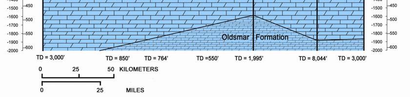
26 SPECIAL PUBLICATION NO. 28 (Revised) permeable sands directly overlie the FAS, the water table generally exists within the sands (Figure 12, left). Occasionally sands overlie the FAS but the water table lies within the carbonates of the FAS (Figure 12, right). As previously stated, if the sands are greater than 10 feet thick, they are generally considered to be part of the SAS. Otherwise, they are generally considered to be part of the FAS. Nevertheless, if site specific hydrologic data demonstrates a high degree of hydraulic connectedness between the SAS and the FAS, the data pre-empt the 10 feet SAS thickness guideline. Figure 12. Surficial sands directly overlying the Floridan aquifer system. Generally, the top of the FAS coincides with the top of the Suwannee Limestone (where it is present) or the top of the Ocala Limestone. In the panhandle, the top of the aquifer system may be the Bruce Creek Limestone, the Chattahoochee and St. Marks Formations, the Chickasawhay Formation, or the Marianna Limestone. In small areas of central peninsular Florida, and in southeast Florida, where the Suwannee and Ocala are missing, the Avon Park Limestone forms the top of the FAS. In portions of southwest Florida, the Tampa Member of the Arcadia Formation of the Hawthorn Group represents the top of the FAS (Arthur et al., 2008). Finally, in a small portion of southeast Florida, an unnamed limestone unit (Armstrong et al., 1985; Weedman et al., 1995) forms the uppermost unit of the FAS. The base of the FAS in the panhandle is at the gradational contact with finegrained siliciclastic rocks belonging to the Middle Eocene Series. In peninsular Florida, the base coincides with the appearance of the regionally persistent sequence of anhydrite beds that lie near the top of the Paleocene Cedar Keys Formation. The base of the FAS may also occur within the Eocene Oldsmar Formation or the Eocene Avon Park Formation where porosity is occluded by pore-filling anhydrite or thin evaporate beds. 19
27 Within the FAS, one or more aquifers (e.g. LFAS and UFAS) may be designated based on vertical variations in water-bearing properties. Similarly, at least one confining unit (i.e. MFCU) is recognized. The MFCU name is simply a modification of the middle confining unit described by Miller (1988). Miller mentioned that it consists of a series of units, both permeable and impermeable, that collectively are mapped as the MFCU. The LFA, the MFCU, and the UFA are mappable units located throughout most, but not all, of the extent of the FAS (Miller, 1988). The term Floridan aquifer system replaces the terms "Floridan aquifer" and "principal artesian aquifer" that previously have been applied to this hydrostratigraphic unit. Since the (Miller, 1988) paper, there have been re-interpretations of the MFCU. For example, Arthur et al. (2008) mentioned that the number of sub-units of the MFCU varies from region to region. They also presented examples of inconsistent nomenclature usage pertaining to the MFCU, especially across water management boundaries. Over time, these and other issues regarding both the FAS and the MFCU will need to be addressed. Hopefully, the guideline presented in this paper will assist in resolving those issues. Undifferentiated Aquifer Systems and Confining Units The UAS/UCU units are strata of varying permeability that lie below the FAS. These systems and units are poorly defined because of inadequate data. From what is known, only broad statements regarding the uppermost sediments can be made. These sediments are of low permeability and they limit the depth of active groundwater circulation in Florida. In peninsular Florida, the uppermost unit is comprised mainly of a sequence of anhydrite beds interlayered with low permeability carbonate rocks belonging to the Paleocene and older Series. In the panhandle of Florida, the uppermost unit consists of fine-grained siliciclastic deposits belonging to the Middle Eocene and older Series. The uppermost unit is marked by the sharp permeability contrast with the more permeable carbonates at the base of the Floridan aquifer system. CALL FOR THE DEVELOPMENT OF A NATIONAL CODE OF HYDROSTRATIGRAPHIC NOMENCLATURE FHUD II considered preparing a draft Code of Hydrostratigraphic Nomenclature for use in Florida, as well as the entire North America. However, it quickly became apparent that, without the oversight of a well respected national entity, efforts by CFHUD II regarding specific nomenclature and mapping issue in Florida would not necessarily be accepted elsewhere. The development of a code of hydrostratigraphic nomenclature and mapping procedures is long overdue for the United States and other nations in North America. With this in mind, CFHUD II supports the formation of a national committee to develop a code of hydrostratigraphic nomenclature and mapping procedures. Note that the North American Commission for Stratigraphic Nomenclature has indicated an interest in establishing such procedures, but has not adopted them at the current time. 20
28 SPECIAL PUBLICATION NO. 28 (Revised) AQUIFER EXTENT AND UTILIZATION Historically, Florida has steadily become more and more dependent upon its groundwater resources. In addition, it is anticipated that Florida will have no choice but to commence a search for new sources of groundwater in order to meet its future demands. For these reasons, the purposes of this section are to: (1) display the areal extent of each fresh-water aquifer system, (2) show where the state s aquifer systems are currently being used in significant quantities, and (3) suggest areas of the state where future groundwater supplies might reasonably be found. Recall that Figure 2 depicts the locations of Florida s counties. For this report, for a county, significant groundwater use is considered to be greater than five percent of its total groundwater use. Total groundwater withdrawals by aquifer system by county for the year 2000 were obtained from Marella and Berndt (2005) and Marella (2006). The authors indicated that in 2000, the total amount of groundwater abstraction per county varied greatly, ranging from a minimum of less 1.8 millions of gallons per day (mgd) (Monroe County) to mgd (Miami-Dade County). Table 2 displays the percentage of the total groundwater withdrawals for each county of the state by aquifer system. The table is a modification of the work of Marella (2006). Using Marella s work, Table 3 depicts the aquifers systems used significantly by water management district and by county. Currently, the IAS is used significantly only in parts of southwest Florida. Figure 13 displays the extent of SAS including the sand-and-gravel aquifer in northwestern Florida and the Biscayne aquifer in the southeastern portion of the state. Where the two aquifers are present on the countywide scale, they are utilized more than either the FAS or the IAS. The SAS (Figure 14) is used extensively throughout southern Florida. The SAS is also utilized significantly in northeastern Florida in Flagler, St. Johns, and Nassau Counties. In the panhandle, in addition to the SGA, the SAS is currently utilized significantly in Gulf County. Miller (1988) indicated that because of the permeable nature of SAS sediment, rainfall easily percolates downward to the water table. From there, groundwater either moves laterally to points where it is discharged into surface streams or vertically downward to recharge either the FAS or the IAS. In portions of the state where there is no other source of groundwater, and the SAS is sufficiently thick, the SAS can potentially supply water for industrial, agricultural, or municipal use. Nevertheless, the sediments making up the SAS are often thin and discontinuous and, for these reasons, groundwater in the SAS is utilized primarily for domestic use. Because of its discontinuous nature, the SAS probably has limited potential for increased water use in the future. Figure 15 displays the extent of the IAS/ICU and where the IAS is used significantly. In the portion of Florida where the IAS is not considered present, the sediments comprising the ICU often do exist. The only portion of the state where the IAS is currently being used significantly is in southwestern Florida. Nevertheless, since the IAS/ICU exists over much of the state, it will likely become a significant source of future groundwater use. 21
29 Figure 16 displays the aerial extent of the FAS in Florida where it is being used significantly. On a coarser scale, it extends from South Carolina to Mississippi. In Florida, it exists beneath the entire state and is the most widely utilized aquifer system. The top of the aquifer system dips to the west in extreme northwestern Florida and to the south in southern Florida. With depth, the groundwater becomes highly mineralized. Figure 16 indicates that the FAS is significantly used everywhere except in the extreme northwestern and southern portions of the state. Table 2. Percentage of total groundwater withdrawals by county and by county and by aquifer system, 2000 [Modified from Marella and Berndt (2005) and Marella (2006)]. County %FAS %IAS %SAS County %FAS %IAS %SAS Alachua Lee Baker Leon Bay Levy Bradford Liberty Brevard Madison Broward < Manatee Calhoun Marion Charlotte Martin Citrus Miami-Dade Clay Monroe Collier Nassau Columbia Okaloosa De Soto Okeechobee Dixie Orange Duval Osceola Escambia Palm Beach Flagler Pasco Franklin Pinellas Gadsden Polk Gilchrist Putnam Glades St. Johns Gulf St. Lucie Hamilton Santa Rosa Hardee Sarasota Hendry Seminole Hernando Sumter Highlands Suwannee Hillsborough Taylor Holmes Union Indian River Volusia Jackson Wakulla Jefferson Walton Lafayette Washington Lake
30 SPECIAL PUBLICATION NO. 28 (Revised) Table 3. Significant groundwater withdrawals by aquifer system by water management district, by county, 2000 [Modified from Marella and Berndt (2005) and Marella (2006)]. Northwest Florida Water Management District Suwannee River Water Management District St. Johns River Water Management District County FAS IAS SAS County FAS IAS SAS County FAS IAS SAS Bay Y Alachua Y Alachua Y Calhoun Y Baker Y Baker Y Escambia Y Bradford Y Brevard Y Y Franklin Y Columbia Y Clay Y Gadsden Y Dixie Y Duval Y Gulf Y Y Gilchrist Y Flagler Y Y Indian River Y Y Holmes Y Hamilton Y Jackson Y Jefferson Y Lake Y Jefferson Y Lafayette Y Marion Y Leon Y Levy Y Nassau Y Y Liberty Y Madison Y Orange Y Okaloosa Y Suwannee Y Osceola Y Santa Rosa Y Y Taylor Y Putnam Y Wakulla Y Union Y St Johns Y Y Walton Y Seminole Y Washington Y Volusia Y Table 3. (continued) Southwest Florida Water Management District South Florida Water Management District County FAS IAS SAS County FAS IAS SAS Citrus Y Broward Y Charlotte Y Y Charlotte Y Y De Soto Y Y Collier Y Y Hardee Y Y Glades Y Y Hernando Y Hendry Y Y Highlands Y Y Highlands Y Y Hillsborough Y Lee Y Y Y Lake Y Martin Y Y Levy Y Miami-Dade Y Manatee Y Monroe Y Y Marion Y Okeechobee Y Y Pasco Y Orange Y Pinellas Y Osceola Y Polk Y Palm Beach Y Sumter Y Polk Y Sarasota Y Y St. Lucie Y Y 23


31 Figure 13. Extent of the surficial aquifer system, including the sand-andgravel aquifer and the Biscayne aquifer. 24


32 SPECIAL PUBLICATION NO. 28 (Revised) Figure 14. Areal extent of surficial aquifer system and where it is used significantly. 25


33 Figure 15. Areal extent of the intermediate aquifer system or the intermediate confining unit and where the aquifer system is used significantly. 26

.")
 can assist in determining new areas of the state that can potentially be used for future groundwater supplies.")
34 SPECIAL PUBLICATION NO. 28 (Revised) Figure 16. Areal extent of the Floridan aquifer system and where it is used Significantly. In closing, consider the following. An aquifer is considered to be a body of rock that contains sufficient saturated permeable material to conduct groundwater and to yield significant quantities of water to wells and springs (Neuendorf et al., 2005). Comparing the areal extent of each aquifer system to the areas where the aquifer systems are currently being used significantly (Figures 14, 15, and 16) can assist in determining new areas of the state that can potentially be used for future groundwater supplies. However, it should also be understood that a potential also exists of encountering: (1) low permeabilities; (2) low quantities of groundwater; and (3) highly mineralized groundwater. Any one of these issues may limit their usage. 27
Number of Child Passenger Safety Instructors by County as of 6/2/2017
 Escambia Santa Rosa Okaloosa Walton Holmes Washington Bay Jackson Gadsden Calhoun Leon Liberty Wakulla Gulf Franklin Jefferson Hamilton Madison Suwannee Taylor Lafayette Dixie Gilchrist Columbia Baker
Voter Registration by Party Affiliation Year to Date Report August 2015
 Page 1 of 10 Republican Party ALACHUA 44,891 44,940 45,112 45,152 45,164 45,214 44,511 44,593 44,791 0 0 0 0 BAKER 6,091 6,116 6,126 6,148 6,154 6,086 6,069 6,086 6,135 0 0 0 0 BAY 55,439 55,559 55,613
Page 1 of 10 Prepared by Florida Department of State - Division of Elections Voter Registration by Party Affiliation Year to Date Report February 2015
 Page 1 of 10 Republican Party ALACHUA 44,891 44,940 45,112 0 0 0 0 0 0 0 0 0 0 BAKER 6,091 6,116 6,126 0 0 0 0 0 0 0 0 0 0 BAY 55,439 55,559 55,613 0 0 0 0 0 0 0 0 0 0 BRADFORD 6,447 6,464 6,375 0 0 0
Voter Registration by Party Affiliation Year to Date Report February 2016
 Page 1 of 10 Republican Party ALACHUA 45,660 45,788 46,714 0 0 0 0 0 0 0 0 0 0 BAKER 6,212 6,242 6,632 0 0 0 0 0 0 0 0 0 0 BAY 54,386 54,647 56,237 0 0 0 0 0 0 0 0 0 0 BRADFORD 6,499 6,506 6,761 0 0 0
Voluntary Prekindergarten Estimating Conference Executive Summary December 7, Principals. Mark Armstrong, Designee
 Voluntary Prekindergarten Estimating Executive Summary December 7, 2009 Principals Office Office of Economic & Demographic Research (Chair) Executive Office of the Governor House of Representatives Senate
FLORIDA EDUCATION FINANCE PROGRAM GOVERNOR'S RECOMMENDED CALCULATION
 2017-18 2018-19 2nd Governor's Recommended Calculation Calculation Difference Difference STUDENT COUNT Unweighted FTE 2,829,107.39 2,856,291.81 27,184.42 0.96% Weighted FTE 3,077,667.93 3,106,707.31 29,039.38
FLORIDA EDUCATION FINANCE PROGRAM GOVERNOR'S RECOMMENDED CALCULATION
 2016-17 2017-18 3rd Governor's Recommended Calculation Calculation Difference Difference STUDENT COUNT Unweighted FTE 2,800,009.16 2,828,202.04 28,192.88 1.01% Weighted FTE 3,033,279.31 3,067,030.86 33,751.55
FLORIDA EDUCATION FINANCE PROGRAM GOVERNOR'S BUDGET RECOMMENDATION CALCULATION rd
 2014-15 2015-16 3rd Governor's Budget Recommendation Calculation Calculation Difference Difference STUDENT COUNT Unweighted FTE 2,733,871.84 2,751,718.00 17,846.16 0.65% Weighted FTE 2,964,193.76 2,984,383.46
CONFERENCE REPORT FOR EDUCATION ESTIMATING CONFERENCE. PreK-12 ENROLLMENT FLORIDA SCHOOL DISTRICT PROGRAMS
 CONFERENCE REPORT FOR EDUCATION ESTIMATING CONFERENCE PreK-12 ENROLLMENT FLORIDA SCHOOL DISTRICT PROGRAMS UNWEIGHTED FULL-TIME EQUIVALENT (FTE) STUDENT ENROLLMENT Tuesday, July 24, 2018 Forecasts of Student
Florida Department of Education FEFP Second Calculation Certified Required Local Effort Millage Rates
 7/17/2017 Attachment 1 Cert. Mills Florida Department of Education 2017-18 FEFP Second Calculation Certified Required Local Effort Millage Rates Certified Prior Potential Additional Total Certified 2017
CHART D-1: RESIDENT DEATHS AND RATES PER 100,000 POPULATION, BY RACE AND GENDER, FLORIDA AND UNITED STATES, CENSUS YEARS AND
 Deaths CHART D-1: RESIDENT DEATHS AND RATES PER 100,000 POPULATION, BY RACE AND GENDER, FLORIDA AND UNITED STATES, CENSUS YEARS 1970-2000 AND 2005-2015 WHITE BLACK YEAR TOTAL WHITE BLACK OTHER MALE FEMALE
A Comparison of Hurricane Loss Models (Preliminary Results)
") A Comparison of Hurricane Loss Models (Preliminary Results) presentation to the Florida House of Representatives Committee on Insurance April 16, 2007 1 Today s Briefing Overview of the Commission How
A Comparison of Hurricane Loss Models (Preliminary Results) presentation to the Florida House of Representatives Committee on Insurance April 16, 2007 1 Today s Briefing Overview of the Commission How
TAMPA BAY TRIBUTARIES BASIN. Hydrogeological Setting
 TAMPA BAY TRIBUTARIES BASIN Hydrogeological Setting Aquifers within the Tampa Bay Tributaries Basins ground water flow system include the Floridan aquifer system, the intermediate aquifer system, and the
. In 2009, Florida resident deaths decreased to 169,854. This is a 0.4 percent decrease from 2008.
 Deaths DEATHS. In 2009, Florida resident deaths decreased to 169,854. This is a 0.4 percent decrease from 2008.. The overall resident death rate per 1,000 population decreased 1.1 percent from 9.1 per
DEATHS. In 2011, Florida resident deaths increased to 172,856. This is a 0.2 percent increase from 2010.
 Deaths DEATHS In 2011, Florida resident deaths increased to 172,856. This is a 0.2 percent increase from 2010. The overall resident death rate decreased slightly from 9.2 in 2010 to 9.1 per 1,000 population
Florida's Refugee Population Statistical Report
 Florida's Refugee Population Statistical Report October 1 st, 2004 September 30 th, 2005 Courtesy of the US Coast Guard Prepared By: Florida Department of Children & Families Refugee Services State of
Florida's Refugee Population Statistical Report
 Florida's Refugee Population Statistical Report October 1 st, 2002 September 30 th, 2003 Courtesy of the US Coast Guard Prepared By: Florida Department of Children & Families Refugee Services State of
BOATING ACCIDENTS STATISTICAL REPORT
 BOATING ACCIDENTS STATISTICAL REPORT BOATING ACCIDENTS STATISTICAL REPORT Personal Watercraft Accidents photo detail Cover Photos: (Courtesy of FWC) NC7-438: On June 24, 207, a was traveling east on Pottsburg
FLORIDA DIVISION OF EMERGENCY MANAGEMENT STATE WATCH OFFICE DAILY INCIDENT REPORT
 FLORIDA DIVISION OF EMERGENCY MANAGEMENT STATE WATCH OFFICE DAILY INCIDENT REPORT Incident Number: 2018-8027 Occurred: 12/30/2018 03:35 ET Reported to SWO: 12/30/2018 03:36 ET Affecting: Broward, Collier,
FLORIDA DIVISION OF EMERGENCY MANAGEMENT STATE WATCH OFFICE DAILY INCIDENT REPORT
 FLORIDA DIVISION OF EMERGENCY MANAGEMENT STATE WATCH OFFICE DAILY INCIDENT REPORT Incident Number: 2018-7765 Incident Name: Areal Flood Watch Occurred: 12/19/2018 04:06 ET Reported to SWO: 12/19/2018 04:07
Geology and Soils. Technical Memorandum
 Geology and Soils Technical Memorandum TO: FDOT FROM: HDR, Inc. DATE: February 2013 PROJECT: St Johns River Crossing FPID No: 208225-3-21-01 Clay, Duval, and St. Johns Counties; Florida Geology and soils
Personal Watercraft Accidents photo detail
 Personal Watercraft Accidents photo detail Cover Photos: (Courtesy of FWC) On August, 06, at approximately :00 pm, a struck a pontoon boat at Stump Pass State Park. The and pontoon boat were both rental
Bureau of Economic and Business Research May 29, Measuring Population Density for Counties in Florida
 Bureau of Economic and Business Research May 29, 2015 Measuring Population Density for Counties in Florida By: Stefan Rayer, PhD; Ying Wang, PhD https://www.bebr.ufl.edu/content/measuring-population-density-counties-florida
ANNUAL POWER POLE INTEGRITY PROGRAM MAY 2005 SUMMARY
 ANNUAL POWER POLE INTEGRITY PROGRAM MAY 2005 SUMMARY Overview In the spring of 2005, due to concern over the number of poles damaged and downed by the storms of 2004, the Commission s Electric Safety group
Florida's Refugee Population Statistical Report
 Florida's Refugee Population Statistical Report October 1 st, 2008 September 30 th, 2009 And Federal Fiscal Year 2005-2009 Courtesy of the US Coast Guard Prepared By: Florida Department of Children & Families
7/29/2012 FLORIDA DEPARTMENT OF STATE DIVISION OF ELECTIONS Primary Election County Voter Registration By Congressional District July 16, 2012.
 Page 1 Congressional District 1 SCAMBIA 83440 70071 0 5 46 3 1 0 1 116 617 3960 333 0 1 35 4 28767 187400 HOLMS 2414 4023 0 0 2 0 0 0 0 4 5 83 5 0 0 0 0 581 7117 OKALOOSA 72644 26647 3 8 21 0 0 0 4 50
Tropical Update 6 AM EDT Friday, October 7, 2016 Hurricane Matthew & Hurricane Nicole
 Tropical Update 6 AM EDT Friday, October 7, 2016 Hurricane Matthew & Hurricane Nicole This update is intended for government and emergency response officials, and is provided for informational and situational
FLORIDA DIVISION OF EMERGENCY MANAGEMENT STATE WATCH OFFICE DAILY INCIDENT REPORT
 FLORIDA DIVISION OF EMERGENCY MANAGEMENT STATE WATCH OFFICE DAILY INCIDENT REPORT Incident Number: 2019-705 Occurred: 2/5/2019 06:00 ET Reported to SWO: 2/5/2019 06:13 ET Affecting: Hillsborough Summary:
Florida s Karst Geology
 Florida s Karst Geology Orange Creek Basin Interagency Working Group Public Workshop, November 5 th, 2015 Harley Means, P.G. Assistant State Geologist Florida Geological Survey Karst Karst a type of topography
Prof. Stephen A. Nelson EENS 111. Groundwater
 Page 1 of 8 Prof. Stephen A. Nelson EENS 111 Tulane University Physical Geology This page last updated on 20-Oct-2003 is water that exists in the pore spaces and fractures in rock and sediment beneath
Econfina Creek Springs
 Econfina Creek Springs Kris Barrios, NWFWMD FDEP IWRM Q-Meeting October 11, 2005 There are two Econfinas Econfina Creek: in my humble opinion, the finer of the two Econfina River: rhymes with bean Definition
Soils, Hydrogeology, and Aquifer Properties. Philip B. Bedient 2006 Rice University
 Soils, Hydrogeology, and Aquifer Properties Philip B. Bedient 2006 Rice University Charbeneau, 2000. Basin Hydrologic Cycle Global Water Supply Distribution 3% of earth s water is fresh - 97% oceans 1%
Measuring Urban Form and Examining Its Impact on Traffic Congestion in Florida
 Measuring Urban Form and Examining Its Impact on Traffic Congestion in Florida By Vince Wang Chair: Ruth Steiner Co-Chair: Andres Blanco March 04, 2011 Department of Urban and Regional Planning Overview
Table 1. August average temperatures and departures from normal ( F) for selected cities.
 for selected cities.") Climate Summary for Florida August 2016 Prepared by Lydia Stefanova and David Zierden Florida Climate Center, The Florida State University, Tallahassee, Florida Online at: http://climatecenter.fsu.edu/products-services/summaries
Climate Summary for Florida August 2016 Prepared by Lydia Stefanova and David Zierden Florida Climate Center, The Florida State University, Tallahassee, Florida Online at: http://climatecenter.fsu.edu/products-services/summaries
Virginia Walsh, PhD, P.G. Ed Rectenwald, P.G. April 5, 2016
 Miami-Dade Water & Sewer Department Cenozoic and Late Mesozoic Geology and Hydrogeology Of a 10,000 foot Exploratory Well Virginia Key, Florida Virginia Walsh, PhD, P.G. Ed Rectenwald, P.G. April 5, 2016
Florida Department of Environmental Protection
 Florida Department of Environmental Protection Bob Martinez Center 2600 Blair Stone Road Tallahassee, Florida 32399-2400 Rick Scott Governor Carlos Lopez-Cantera Lt. Governor Noah Valenstein Secretary
Tropical Update. 12 PM EDT Friday, October 7, 2016 Hurricane Matthew & Tropical Storm Nicole
 Tropical Update 12 PM EDT Friday, October 7, 2016 Hurricane Matthew & Tropical Storm Nicole This update is intended for government and emergency response officials, and is provided for informational and
Shallow Karst Aquifer System of the Lake Belt Study Area, Miami-Dade County, Florida, USA EXTENDED ABSTRACT
 Second International Conference on Saltwater Intrusion and Coastal Aquifers Monitoring, Modeling, and Management. Merida, Mexico, March 30 April 2, 2003 Shallow Karst Aquifer System of the Lake Belt Study
Identifying Sensitive Aquifers in Ohio
 State of Ohio Environmental Protection Agency Division of Drinking and Ground Waters Identifying Sensitive Aquifers in Ohio May 2007 Ted Strickland, Governor Chris Korleski, Director Acknowledgments Ohio
FLORIDA DIVISION OF EMERGENCY MANAGEMENT STATE WATCH OFFICE DAILY INCIDENT REPORT
 FLORIDA DIVISION OF EMERGENCY MANAGEMENT STATE WATCH OFFICE DAILY INCIDENT REPORT Incident Number: 2018-7172 Incident Name: Dense Fog Advisory Occurred: 11/20/2018 05:02 ET Reported to SWO: 11/20/2018
Evaluation of Subsurface Formation of Pabna District, Bangladesh
 IOSR Journal of Applied Geology and Geophysics (IOSR-JAGG) e-issn: 2321 0990, p-issn: 2321 0982.Volume 1, Issue 4 (Sep. Oct. 2013), PP 30-36 Evaluation of Subsurface Formation of Pabna District, Bangladesh
GEOL And a Quick Review of Sedimentary Rocks and Processes
 GEOL 3000 And a Quick Review of Sedimentary Rocks and Processes North American Stratigraphic Code A formulation of current views on stratigraphic principles and procedures designed to promote standardized
Groundwater Hydrology
 EXERCISE 12 Groundwater Hydrology INTRODUCTION Groundwater is an important component of the hydrologic cycle. It feeds lakes, rivers, wetlands, and reservoirs; it supplies water for domestic, municipal,
Essentials of Geology, 11e
 Essentials of Geology, 11e Groundwater Chapter 10 Instructor Jennifer Barson Spokane Falls Community College Geology 101 Stanley Hatfield Southwestern Illinois Co Jennifer Cole Northeastern University
Groundwater Resources of Missouri. Cynthia Brookshire, R. G.
 Groundwater Resources of Missouri Cynthia Brookshire, R. G. GROUNDWATER... Water beneath the Earth s surface within a zone of saturation AQUIFER... A geologic formation or group of formations that are
Land subsidence due to groundwater withdrawal in Hanoi, Vietnam
 Land Subsidence (Proceedings of the Fifth International Symposium on Land Subsidence, The Hague, October 1995). 1AHS Publ. no. 234, 1995. 55 Land subsidence due to groundwater withdrawal in Hanoi, Vietnam
FLORIDA DIVISION OF EMERGENCY MANAGEMENT STATE WATCH OFFICE DAILY INCIDENT REPORT
 FLORIDA DIVISION OF EMERGENCY MANAGEMENT STATE WATCH OFFICE DAILY INCIDENT REPORT Incident Number: 2018-6310 Incident Name: River Flood Warning (Suwannee River at Fowler Bluff CR 347) Occurred: 10/10/2018
REVISION OF AFSIRS CROP WATER USE SIMULATION MODEL AFSIRS TASK 13 CLIMATE DATABASE IMPLEMENTATION
 Final Report REVISION OF AFSIRS CROP WATER USE SIMULATION MODEL AFSIRS TASK 13 CLIMATE DATABASE IMPLEMENTATION By Investigators: Jennifer M. Jacobs Department of Civil Engineering University of New Hampshire
EVALUATION OF THE DOWNWARD MIGRATION OF SALTWATER TO THE UPPER FLORIDAN AQUIFER IN THE SAVANNAH, GEORGIA, AND HILTON HEAD ISLAND, SOUTH CAROLINA, AREA
 EVALUATION OF THE DOWNWARD MIGRATION OF SALTWATER TO THE UPPER FLORIDAN AQUIFER IN THE SAVANNAH, GEORGIA, AND HILTON HEAD ISLAND, SOUTH CAROLINA, AREA Camille Ransom, III 1, James E. Landmeyer 2, W. Robert
The Favorability of Florida s Geology to Sinkhole Formation
 Florida Geological Survey The Favorability of Florida s Geology to Sinkhole Formation Clint Kromhout Alan Baker October 24, 2017 Subsidence Report Database Map of Subsidence Incident Reports taken from
A method for three-dimensional mapping, merging geologic interpretation, and GIS computation
 A method for three-dimensional mapping, merging geologic interpretation, and GIS computation Soller, David R., U.S. Geological Survey, 908 National Center, Reston, VA 20192 and Richard C. Berg, Illinois
Section 3.0 State Risk Assessment August 2013
 Table of Contents Introduction...3.7 3.1 Identifying Hazards...3.10 3.2 Profiling Florida s Hazards...3.19 3.2.1 2013 Methodology for Analyzing Vulnerability...3.19 3.2.2 Hazard Profiling...3.21 3.2.3
TECHNICAL PUBLICATION SJ WATER SUPPLY ASSESSMENT 2003 ST. JOHNS RIVER WATER MANAGEMENT DISTRICT
 TECHNICAL PUBLICATION SJ2006-1 WATER SUPPLY ASSESSMENT 2003 ST. JOHNS RIVER WATER MANAGEMENT DISTRICT Technical Publication SJ2006-1 Water Supply Assessment 2003 Palatka, Florida 2006 Northwest Florida
HYDROGEOLOGICAL PROPERTIES OF THE UG2 PYROXENITE AQUIFERS OF THE BUSHVELD COMPLEX
 R. Gebrekristos, P.Cheshire HYDROGEOLOGICAL PROPERTIES OF THE UG2 PYROXENITE AQUIFERS OF THE BUSHVELD COMPLEX R. Gebrekristos Digby Wells Environmental P. Cheshire Groundwater Monitoring Services Abstract
Chapter 13. Groundwater
 Chapter 13 Groundwater Introduction Groundwater is all subsurface water that completely fills the pores and other open spaces in rocks, sediments, and soil. Groundwater is responsible for forming beautiful
 12 10 8 6 4 2 0 40-50 50-60 60-70 70-80 80-90 90-100 Fresh Water What we will cover The Hydrologic Cycle River systems Floods Groundwater Caves and Karst Topography Hot springs Distribution of water in
Chapter 14. Groundwater
 Chapter 14 Groundwater Importance of groundwater! Groundwater is water found in the pores of soil and sediment, plus narrow fractures in bedrock! Groundwater is the largest reservoir of fresh water that
Groundwater. (x 1000 km 3 /y) Oceans Cover >70% of Surface. Groundwater and the. Hydrologic Cycle
 Oceans Cover >70% of Surface. Groundwater and the. Hydrologic Cycle") Chapter 17 Oceans Cover >70% of Surface Groundwater and the Hydrologic Cycle Vasey s Paradise, GCNP Oceans are only 0.025% of Mass Groundwater Groundwater is liquid water that lies in the subsurface in
Chapter 17 Oceans Cover >70% of Surface Groundwater and the Hydrologic Cycle Vasey s Paradise, GCNP Oceans are only 0.025% of Mass Groundwater Groundwater is liquid water that lies in the subsurface in
Groundwater. (x 1000 km 3 /y) Reservoirs. Oceans Cover >70% of Surface. Groundwater and the. Hydrologic Cycle
 Reservoirs. Oceans Cover >70% of Surface. Groundwater and the. Hydrologic Cycle") Chapter 13 Oceans Cover >70% of Surface Groundwater and the Hydrologic Cycle Oceans are only 0.025% of Mass Groundwater Groundwater is liquid water that lies in the subsurface in fractures in rocks and
Chapter 13 Oceans Cover >70% of Surface Groundwater and the Hydrologic Cycle Oceans are only 0.025% of Mass Groundwater Groundwater is liquid water that lies in the subsurface in fractures in rocks and
RESISTIVITY IMAGING AND BOREHOLE INVESTIGATION OF THE BANTING AREA AQUIFER, SELANGOR, MALAYSIA. A.N. Ibrahim Z.Z.T. Harith M.N.M.
 JOURNAL OF ENVIRONMENTAL HYDROLOGY The Electronic Journal of the International Association for Environmental Hydrology On the World Wide Web at http://www.hydroweb.com VOLUME 11 2003 RESISTIVITY IMAGING
Geological Survey of Alabama Groundwater Assessment Program
 Geological Survey of Alabama Groundwater Assessment Program Hydrogeologic Characterization and Groundwater Source Development Assessment for Area 2, Southwestern Alabama Gheorghe M. Ponta, Marlon R. Cook,
B. T. Brady, M. S. Bedinger, John Mikels, William H. Langer, and Deborah A. Mulvihill
 DEPARTMENT OF THE INTERIOR UNITED STATES GEOLOGICAL SURVEY TO ACCOMPANY WRI REPORT 83-4121-B MAP SHOWING GROUND-WATER LEVELS, SPRINGS. AND DEPTH TO GROUND WATER, BASIN AND RANGE PROVINCE, TEXAS by B. T.
FLORIDA DIVISION OF EMERGENCY MANAGEMENT STATE WATCH OFFICE DAILY INCIDENT REPORT
 FLORIDA DIVISION OF EMERGENCY MANAGEMENT STATE WATCH OFFICE DAILY INCIDENT REPORT Incident Number: 2018-7477 Incident Name: Woodville Highway Closed Occurred: 12/6/2018 05:29 ET Reported to SWO: 12/6/2018
11/22/2010. Groundwater in Unconsolidated Deposits. Alluvial (fluvial) deposits. - consist of gravel, sand, silt and clay
 deposits. - consist of gravel, sand, silt and clay") Groundwater in Unconsolidated Deposits Alluvial (fluvial) deposits - consist of gravel, sand, silt and clay - laid down by physical processes in rivers and flood plains - major sources for water supplies
Groundwater in Unconsolidated Deposits Alluvial (fluvial) deposits - consist of gravel, sand, silt and clay - laid down by physical processes in rivers and flood plains - major sources for water supplies
BUFFALO RIVER COALITION PO Box 101, Jasper, AR (870)
") BUFFALO RIVER COALITION PO Box 101, Jasper, AR 72641 (870) 446-5783 buffalowatershed@gmail.com Presentation before Arkansas Pollution Control and Ecology Commission, April 29, 2016 by Richard Mays on behalf
BUFFALO RIVER COALITION PO Box 101, Jasper, AR 72641 (870) 446-5783 buffalowatershed@gmail.com Presentation before Arkansas Pollution Control and Ecology Commission, April 29, 2016 by Richard Mays on behalf
KANSAS GEOLOGICAL SURVEY Open File Report LAND SUBSIDENCE KIOWA COUNTY, KANSAS. May 2, 2007
 KANSAS GEOLOGICAL SURVEY Open File Report 2007-22 LAND SUBSIDENCE KIOWA COUNTY, KANSAS Prepared by Michael T. Dealy L.G., Manager, Wichita Operations SITE LOCATION The site was approximately four miles
Evolution of the conceptual hydrogeologic and ground-water flow model for Las Vegas Valley, Clark County, Nevada
 Evolution of the conceptual hydrogeologic and ground-water flow model for Las Vegas Valley, Clark County, Nevada Geological Society of America Annual Meeting November 14, 2 David J. Donovan Southern Nevada
FINAL REPORT THE FLORIDA DEPARTMENT OF TRANSPORTATION SYSTEMS PLANNING OFFICE. on Project
 FINAL REPORT to THE FLORIDA DEPARTMENT OF TRANSPORTATION SYSTEMS PLANNING OFFICE on Project Multimodal and Corridor Applications of Travel Time Reliability FDOT Contract BDK77 977-10 March 30, 2012 from
Report of Preliminary Geotechnical Investigation for Ponds
 Florida Department of TRANSPORTATION Report of Preliminary Geotechnical Investigation for Ponds Malabar Road (SR 514) PD&E Study From East of Babcock Street (SR 507) to US 1 Brevard County, Florida FPID:
Chapter 8 Fetter, Applied Hydrology 4 th Edition, Geology of Groundwater Occurrence
 Chapter 8 Fetter, Applied Hydrology 4 th Edition, 2001 Geology of Groundwater Occurrence Figure 8.42. Alluvial Valleys ground-water region. Fetter, Applied Hydrology 4 th Edition, 2001 Fetter, Applied
M14AC00004 Florida Cooperative Agreement:
 M14AC00004 Florida Cooperative Agreement: Synthesis of Existing Geophysical Data from Selected Areas on the Outer Continental Shelf Along Florida s Central East Coast. Florida Sand Management Working Group
SUBBOTTOM PROFILING INVESTIGATION OF SINKHOLE LAKE STRUCTURE IN BAY AND WASHINGTON COUNTIES, FLORIDA
 SUBBOTTOM PROFILING INVESTIGATION OF SINKHOLE LAKE STRUCTURE IN BAY AND WASHINGTON COUNTIES, FLORIDA Thomas L. Dobecki, Sam B. Upchurch, Thomas M. Scott, Beth Fratesi, Michael C. Alfieri SDII Global Corporation,
Regional groundwater mapping and model
 Regional groundwater mapping and model Boyd, Dwight 1, Steve Holysh 2, and Jeff Pitcher 1 1 Grand River Conservation Authority, Canada; 2 Regional Municipality of Halton, Canada The Grand River forms one
Ground Water in the Piedmont and Blue Ridge
 engineering earth's development preserving earth's integrity Engineering Earth s Development Preserving Earth s Integrity Ground Water in the Piedmont and Blue Ridge Jim Renner Acknowledgements Contributors:
ETOFENPROX PRALLETHRIN/SUMITHRIN SUMITHRIN MOSQUITO CONTROL PROGRAMS
 Florida Aerial Adulticiding Liquid by District, Formulation and Active Ingredient Aerial Adulticiding Gallons based on Monthly Activity Reports provided to FDACS STATE APPROVED FYFANON NALED PERMETHRIN
Sacramento Valley Groundwater Basin, Sutter Subbasin
 Sacramento Valley Groundwater Basin, Sutter Subbasin Groundwater Basin Number: 5-21.62 County: Sutter Surface Area: 234,400 acres (366 square miles) Boundaries and Hydrology The Sutter Subbasin lies in
FUNDAMENTALS OF ENGINEERING GEOLOGY
 FUNDAMENTALS OF ENGINEERING GEOLOGY Prof. Dr. HUSSEIN HAMEED KARIM Building and Construction Engineering Department 2012 Preface The impulse to write this book stemmed from a course of geology given by
DATA ACQUISITION METHODS FOR GROUNDWATER INVESTIGATION AND THE SITING OF WATER SUPPLY WELLS
 DATA ACQUISITION METHODS FOR GROUNDWATER INVESTIGATION AND THE SITING OF WATER SUPPLY WELLS M.B.J. Foster Tetra Tech EM Inc., San Francisco, CA, USA Keywords: Groundwater, water wells, drilled wells, geophysical
,Baynes Lake. TO...?&.?...A 2...KO.?'!!&... Sr. *logical Engineer
 > i evernment OF BRITISH COLUMBIA a TO...?&.?...A 2....KO.?'!!&... Sr. *logical Engineer... Grou,,water. Section Hydrology Division Wat.er... In~.~s.tiga.ti.On.s..Branck.... 5 u BJECT...C;.roun.dw.ater...Snve
Lab 9: Petroleum and groundwater
 Geology 101 Name(s): Lab 9: Petroleum and groundwater Petroleum (oil) is a multi-component liquid refined to generate different hydrocarbons, such as heptane (a component of gasoline) and waxes. For the
Illinois Drought Update, December 1, 2005 DROUGHT RESPONSE TASK FORCE Illinois State Water Survey, Department of Natural Resources
 Illinois Drought Update, December 1, 2005 DROUGHT RESPONSE TASK FORCE Illinois State Water Survey, Department of Natural Resources For more drought information please go to http://www.sws.uiuc.edu/. SUMMARY.
Lecture Outlines PowerPoint. Chapter 5 Earth Science 11e Tarbuck/Lutgens
 Lecture Outlines PowerPoint Chapter 5 Earth Science 11e Tarbuck/Lutgens 2006 Pearson Prentice Hall This work is protected by United States copyright laws and is provided solely for the use of instructors
Chapter 14: Groundwater. Fig 14.5b
 Chapter 14: Groundwater Fig 14.5b OBJECTIVES Recognize that groundwater is a vital source of accessible freshwater. Describe how groundwater forms below the water table. Explain the origin of aquifers,
Biostratigraphic and Lithostratigraphic Correlation of Sedimentary Strata in the Atlantic Coastal Plain
 Biostratigraphic and Lithostratigraphic Correlation of Sedimentary Strata in the Atlantic Coastal Plain Introduction to the Atlantic Coastal Plain (Please read this page prior to doing the lab) The Atlantic
FLORIDA DIVISION OF EMERGENCY MANAGEMENT STATE WATCH OFFICE DAILY INCIDENT REPORT
 FLORIDA DIVISION OF EMERGENCY MANAGEMENT STATE WATCH OFFICE DAILY INCIDENT REPORT Incident Number: 2018-6664 Incident Name: Southbound I-75 Closed Occurred: 10/26/2018 01:26 ET Reported to SWO: 10/26/2018
FINAL REPORT GEOPHYSICAL INVESTIGATION VILLAGE ALHAMBRA RETENTION POND SITE THE VILLAGES, FLORIDA
 FINAL REPORT GEOPHYSICAL INVESTIGATION VILLAGE ALHAMBRA RETENTION POND SITE THE VILLAGES, FLORIDA Prepared for Andreyev Engineering, Inc. Oxford, FL Prepared by GeoView, Inc. St. Petersburg, FL August
Why Study Groundwater?
 Groundwater Water filling open spaces in rock, sediment, and soil beneath the surface is called groundwater. This natural resource is as important to human endeavors as surface water. Groundwater is an
Thank you for your participation!
 Thank you for your participation! We need your help! Orange County is working to become less vulnerable to flooding, and your participation is important to us! This is an opportunity for you to share your
Alamitos Barrier Improvement Project - UPDATE
 Alamitos Barrier Improvement Project - UPDATE Seal Beach Leisure World Community Meeting Clubhouse 2 August 31, 2016 Orange County Water District Meeting Objectives Overview of OCWD Overview of the Alamitos
Harvey Thorleifson, Director, Minnesota Geological Survey. Status of geological mapping needed for groundwater protection in Minnesota
 Harvey Thorleifson, Director, Minnesota Geological Survey Status of geological mapping needed for groundwater protection in Minnesota Minnesota is located between the Dakotas and Wisconsin, north of Iowa,
Proposed Cemetery Thornhill Road. Tier One Hydrogeological Risk Assessment. Peter Mitchell Associates
 Proposed Cemetery Thornhill Road Tier One Hydrogeological Risk Assessment Peter Mitchell Associates January 2015 Executive Summary This report uses a desk-based risk assessment technique published by the
Napa Valley Groundwater Sustainability: A Basin Analysis Report for the Napa Valley Subbasin
 Napa Valley Groundwater Sustainability: A Basin Analysis Report for the Napa Valley Subbasin A report prepared pursuant to California Water Code Section 10733.6(b)(3) EXECUTIVE SUMMARY (354.4(A)) 1 1.0
PRELIMINARY. Select Geophysical Methods and Groundwater Modeling: Examples from USGS studies. Claudia Faunt and a cast of others
 Select Geophysical Methods and Groundwater Modeling: Examples from USGS studies Claudia Faunt and a cast of others Current Preliminary Studies Stanford Water in the West Groundwater Data Workshop Series:
What we will cover. The Hydrologic Cycle. River systems. Floods. Groundwater. Caves and Karst Topography. Hot springs
 Fresh Water What we will cover The Hydrologic Cycle River systems Floods Groundwater Caves and Karst Topography Hot springs On a piece of paper, put these reservoirs of water in to order from largest to
STATE OF FLORIDA DEPARTMENT OF ENVIRONMENTAL PROTECTION Virginia B. Wetherell, Secretary
 )' -- - STATE OF FLORIDA DEPARTMENT OF ENVIRONMENTAL PROTECTION Virginia B. Wetherell, Secretary DIVISION OF ADMINISTRATIVE AND TECHNICAL SERVICES Nevin G. Smith, Director FLORIDA GEOLOGICAL SURVEY Walter
STATE OF FLORIDA. DEPARTMENT OF ENVIRONMENTAL PROTECTION Michael W. Sole, Secretary. LAND AND RECREATION Robert G. Ballard, Deputy Secretary
 STATE OF FLORIDA DEPARTMENT OF ENVIRONMENTAL PROTECTION Michael W. Sole, Secretary LAND AND RECREATION Robert G. Ballard, Deputy Secretary FLORIDA GEOLOGICAL SURVEY Jonathan D. Arthur, State Geologist
SURFACE GEOLOGY AND LIQUEFACTION SUSCEPTIBILITY IN THE INNER RIO GRANDE VALLEY NEAR ALBUQUERQUE, NEW MEXICO
 SURFACE GEOLOGY AND LIQUEFACTION SUSCEPTIBILITY IN THE INNER RIO GRANDE VALLEY NEAR ALBUQUERQUE, NEW MEXICO Keith I. Kelson, Christopher S. Hitchcock, and Carolyn E. Randolph William Lettis & Associates,
Critical Aquifer Recharge Area Susceptibility Index Methodology
 Prepared for 207 4th Ave. N. Kelso, WA 98626 Prepared by Parametrix 700 NE Multnomah, Suite 1000 Portland, OR 97232-4110 T. 503.233.2400 T. 360.694.5020 F. 1.855.542.6353 www.parametrix.com July 5, 2016
Appendix D. Sediment Texture and Other Soil Data
 5 6 7 8 Appendix D. Sediment Texture and Other Soil Data This appendix describes the sediment texture of the aquifer system in the Restoration Area. The contents of this appendix describe the: Importance
Computer Modeling and Surface Geophysics Unravel the Mystery of Salt Water Intrusion on Long Island
 First International Conference on Saltwater Intrusion and Coastal Aquifers Monitoring, Modeling, and Management. Essaouira, Morocco, April 23 25, 2001 Computer Modeling and Surface Geophysics Unravel the