OBS data from the Møre Margin. Trond Kvarven University of Bergen
|
|
|
- Ralf Caldwell
- 5 years ago
- Views:
Transcription
1 OBS data from the Møre Margin Trond Kvarven University of Bergen
2 Disposal Where is Møre Margin? Why Møre Margin? Acquisition Expected results Examples of seismograms Next steps

3 Møre Margin Kandilarov et al., 2009

4 Why. Module 5. University of Bergen. Ocean Bottom Seismic profile on the continental margin. Project leader: : Prof. Rolf Mjelde. From TopoScandiaDeep s homepage
5 Why. The Møre Margin comprises the Møre Basin and the Møre Marginal High and is located south of the more intensive geological and geophysical studied Vøring Margin. The landward Møre- topography is alpine dominated, whilst the landward topography of Vøring is not. The regional geology is dominated by km deep Cretaceous sedimentary basins which lies landward of the Marginal Highs. The tectonic development of the area is controlled by two structural trends; NE-SW (expressed by faults and basin axes ) and NW-SE (expressed by major fracture zones and lineaments). Profile 2 Profile 1 Profile 3 Modified from Blystad et al., 1995

6 Why. The Møre Margin comprises the Møre Basin and the Møre Marginal High and is located south of the more intensive geological and geophysical studied Vøring Margin. The landward Møre- topography is alpine dominated, whilst the landward topography of Vøring is not. The regional geology is dominated by km deep Cretaceous sedimentary basins which lies landward of the Marginal Highs. The tectonic development of the area is controlled by two structural trends; NE-SW (expressed by faults and basin axes ) and NW-SE (expressed by major fracture zones and lineaments). Profile 2 Profile 1 Profile 3 Modified from Blystad et al., 1995

7 Why. The Møre Margin comprises the Møre Basin and the Møre Marginal High and is located south of the more intensive geological and geophysical studied Vøring Margin. The landward Møre- topography is alpine dominated, whilst the landward topography of Vøring is not. The regional geology is dominated by km deep Cretaceous sedimentary basins which lies landward of the Marginal Highs. The tectonic development of the area is controlled by two structural trends; NE-SW (expressed by faults and basin axes ) and NW-SE (expressed by major fracture zones and lineaments). Profile 2 Profile 1 Profile 3 Modified from Blystad et al., 1995
8 Jan Mayen Fracture Zone Why. Jan Mayen Lineament? The Møre Margin comprises the Møre Basin and the Møre Marginal High and is located south of the more intensive geological and geophysical studied Vøring Margin. The landward Møre- topography is alpine dominated, whilst the landward topography of Vøring is not. The regional geology is dominated by km deep Cretaceous sedimentary basins which lies landward of the Marginal Highs. The tectonic development of the area is controlled by two structural trends; NE-SW (expressed by faults and basin axes ) and NW-SE (expressed by major fracture zones and lineaments). Profile 2 Profile 1 Profile 3 Møre Trøndelag Fault Complex Modified from Blystad et al., 1995
9 Acqusition The acquisition of the three crustal scale (OBS) profiles was performed during a cruise from May 24th to June 9th, Profile 1 and 2 were extended by land-stations stations. The survey was accompanied by gravity and magnetic measurements. The quality ranges from poor (< 40 km) to good (> 120 km). Mjelde & Minakov, 2009
10 Acquisition Seismic source: Four equal seized 1200 inch3 air-guns with a total volume of 4800 inch3. The shooting interval was approximately 200 meters. Lengt of the profiles: Profile 1: 281 km Profile 2: km Profile 3: km 1% of the data along the profiles was lost, 2.5% of the profiles was acquired with 2 air-guns, 33% with 3 air-guns, and 10% was acquired with low pressure. Strong breeze to gale prevailed during most of the survey. Gravity, magnetic and single-channel streamer data were acquired without problems along all profiles
11 Expected results Establish onshore-offshore offshore relationship (Profile 1 og 2). Gain more knowledge about the role of the inherited Precambrian grain (reflected in the fracture zones, lineaments, basin axes and a faults) in the Neogene uplift process. Achieve better mapping of the high velocity bodies included the Caledonian eclogites present within the lower crust off Norway. Elucidate if there is interplay between magma dynamics and inherited Precambrian structures.
 in the Neogene uplift process.")
12 Expected results Establish onshore-offshore offshore relationship (Profile 1 og 2). Gain more knowledge about the role of the inherited Precambrian grain (reflected in the fracture zones, lineaments, basin axes and a faults) in the Neogene uplift process. Achieve better mapping of the high velocity bodies included the Caledonian eclogites present within the lower crust off Norway. Elucidate if there is interplay between magma dynamics and inherited Precambrian structures.
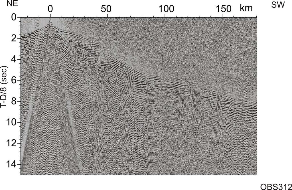
13 Seismograms Profile 1
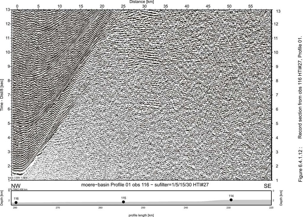
14 Seismograms Profile 1
15 Seismograms Profile 1
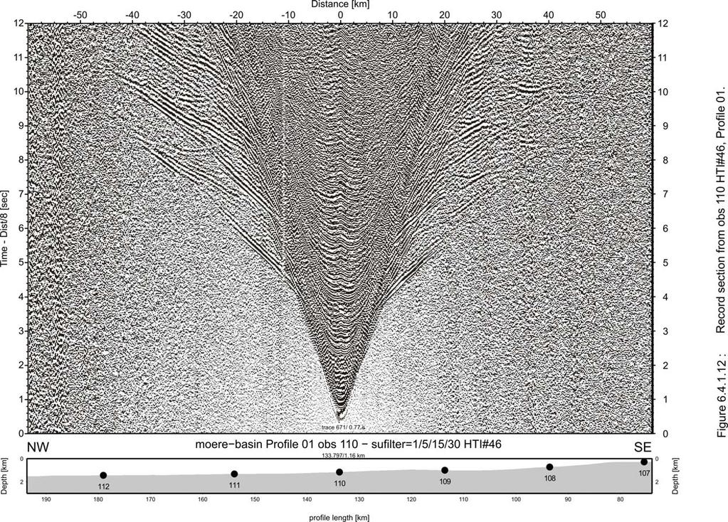
16 Seismograms Profile 1
17 Seismograms Profile 1

18 Seismograms Profile 1
19 Seismograms Profile 2
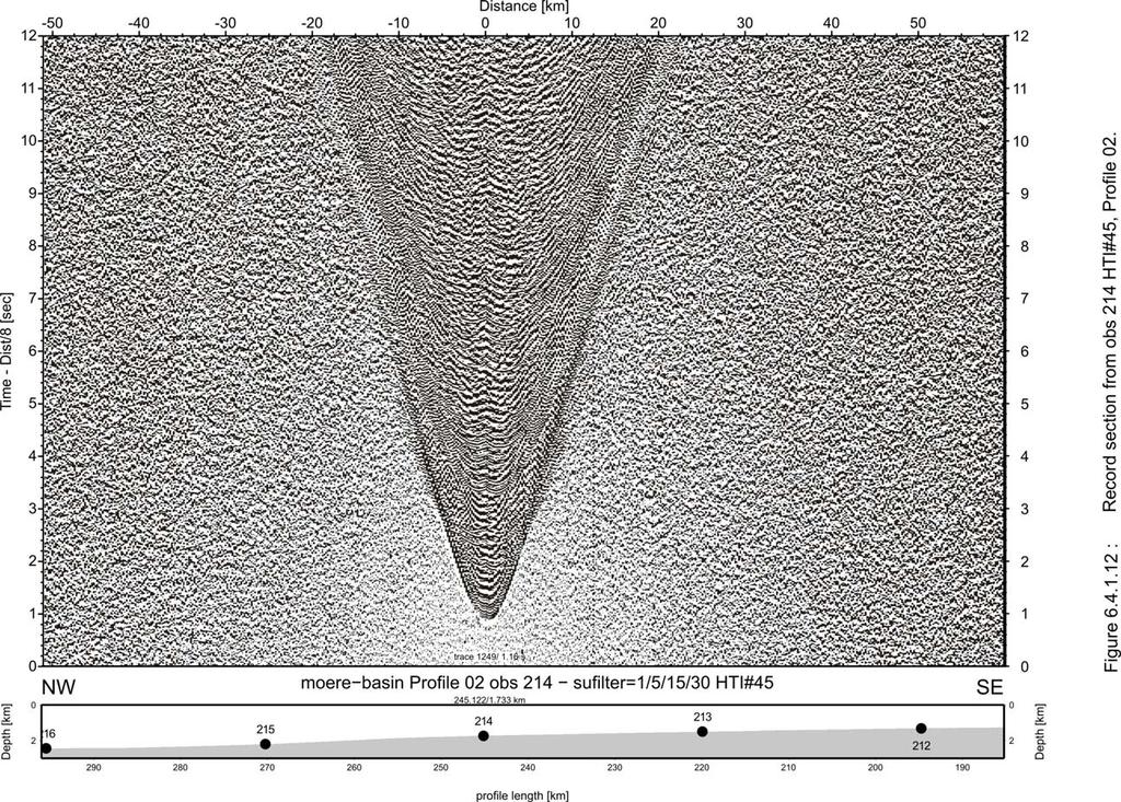
20 Seismograms Profile 2

21 Seismograms Profile 2
22 Seismograms Profile 2

23 Seismograms Profile 2
24 Seismograms Profile 3
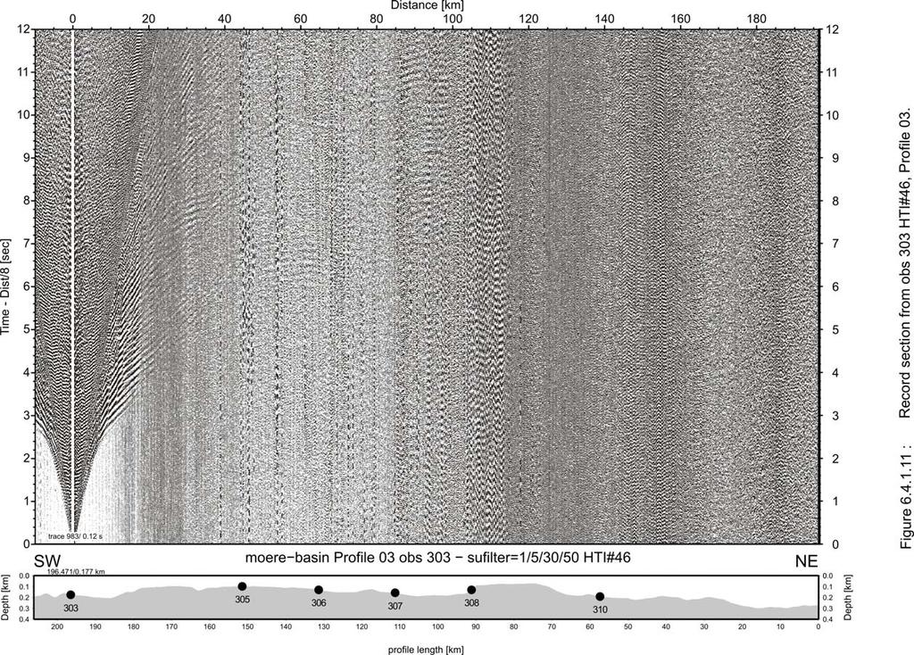
25 Seismograms Profile 3
26 Seismograms Profile 3
27 Seismograms Profile 3
28 Next steps. During 2009 Further processing Modeling of Profile 3 During 2010 Modeling of Profile 1 and 2
3D lithospheric-scale structural model of the Norwegian continental margin (the Vøring and Møre basins)
") Magdalena Scheck-Wenderoth and Yuriy Maystrenko 3D lithospheric-scale structural model of the Norwegian continental margin (the Vøring and Møre basins) Scientific Technical Report STR11/02 - Data www.gfz-potsdam.de
Magdalena Scheck-Wenderoth and Yuriy Maystrenko 3D lithospheric-scale structural model of the Norwegian continental margin (the Vøring and Møre basins) Scientific Technical Report STR11/02 - Data www.gfz-potsdam.de
Implications of new long-offset seismic lines on the Norwegian Continental Shelf
 Implications of new long-offset seismic lines on the Norwegian Continental Shelf L. Gernigon Continental Shelf Geophysics, Geological Survey of Norway (NGU) Force seminar GWL/NGU BASMARGE Project Stavanger,
Title. CitationTectonophysics, 626: Issue Date Doc URL. Rights. Type. File Information.
 Title Crustal structure across the More margin, mid-norway Kvarven, Trond; Ebbing, Jorg; Mjelde, Rolf; Faleide, Author(s) Yoshio CitationTectonophysics, 626: 21-40 Issue Date 2014-06-20 Doc URL http://hdl.handle.net/2115/56858
Isostatic state and density structure from surface to depth of the lithosphere below the Norwegian continental margin
 Isostatic state and density structure from surface to depth of the lithosphere below the Norwegian continental margin Jörg Ebbing (1,2), Odleiv Olesen (1), Torleif Lauritsen (1), R. Fjalar Reynisson (3,2)
Play fairway mapping in the Northeast Atlantic Margin Comparison between mature and immature basins. David Mudge, Joanne Cranswick
 Play fairway mapping in the Northeast Atlantic Margin Comparison between mature and immature basins David Mudge, Joanne Cranswick Contents Ternan North Sea Play fairway mapping Tertiary case study Northeast
Full crustal seismic imaging in northeast Greenland
 Full crustal seismic imaging in northeast Greenland James W. Granath, 1 Richard C. Whittaker, 2 Vijay Singh, 3 Dale E. Bird 3 and Menno G. Dinkelman 4 describe new techniques used to acquire a 2D seismic
BASMARGE: Basement and Margin Ultra-Deep Imaging Seismic Survey of the Norwegian Offshore Realm
 BASMARGE: Basement and Margin Ultra-Deep Imaging Seismic Survey of the Norwegian Offshore Realm In this joint project of Geology Without Limits (GWL) and the Geological Survey of Norway (NGU), several
Modern geodynamic model of the Arctic Ocean
 Modern geodynamic model of the Arctic Ocean O. Petrov, N. Sobolev, A. Morozov, G. Grikurov, S. Shokalsky, S. Kashubin, E. Petrov Vienna, April 2012 Atlas of Geological Maps of the Circumpolar Arctic Magnetic
Controls on clastic systems in the Angoche basin, Mozambique: tectonics, contourites and petroleum systems
 P2-2-13 Controls on clastic systems in the Angoche basin, Mozambique: tectonics, contourites and petroleum systems Eva Hollebeek, Olivia Osicki, Duplo Kornpihl Schlumberger, London, UK Introduction Offshore
JMRS11 Jan Mayen Ridge Sampling Survey 2011
 JMRS11 Jan Mayen Ridge Sampling Survey 2011 JMRS11 Report Presentation VBPR/TGS, February 2012 Confidentiality Screen dumps and the underlying data in this document are confidential and proprietary to
Blocks offered in Sri Lanka s Second Licensing Round
 Blocks offered in Sri Lanka s Second Licensing Round Sri Lankan Main Basins Cauvery Basin Cauvery Deep Water sub-basin Mannar Basin 2 Structural Framework Sri Lanka Basins Cauvery & Mannar Basins were
Non-living Resources of the OCS. Harald Brekke NPD
 Non-living Resources of the OCS Harald Brekke NPD The Continental Shelf and the Area http://www.grida.no/publications/shelf-last-zone/ Outer Continental Shelf Example http://www.grida.no/publications/shelf-last-zone/
HDR/EGS POTENTIAL OF THE VILKYCIAI AREA, WEST LITHUANIA
 HDR/EGS POTENTIAL OF THE VILKYCIAI AREA, WEST LITHUANIA Prepared by Saulius Sliaupa, Dainius Michelevicius, Gediminas Motuza, Larisa Korabliova, Kirstina Ciuraite West Lithuania is situated in the central
Orphan Basin, Offshore Newfoundland: New seismic data and hydrocarbon plays for a dormant Frontier Basin
 Orphan Basin, Offshore Newfoundland: New seismic data and hydrocarbon plays for a dormant Frontier Basin Jerry Smee* G&G Exploration Consulting, 301 400-3rd Avenue SW, Calgary, AB, T2P 4H2 Sam Nader, Paul
Passive Margin Structure Constrained by Geophysical Studies. Ricardo Trindade
 Passive Margin Structure Constrained by Geophysical Studies Ricardo Trindade 3 Departments: Astronomy (31 faculty members) Geophysics (20 faculty members) Atmospheric Sciences (18 faculty members) 3 INCT-CNPq,
Global Tectonics. Kearey, Philip. Table of Contents ISBN-13: Historical perspective. 2. The interior of the Earth.
 Global Tectonics Kearey, Philip ISBN-13: 9781405107778 Table of Contents Preface. Acknowledgments. 1. Historical perspective. 1.1 Continental drift. 1.2 Sea floor spreading and the birth of plate tectonics.
We A10 12 Common Reflection Angle Migration Revealing the Complex Deformation Structure beneath Forearc Basin in the Nankai Trough
 We A10 12 Common Reflection Angle Migration Revealing the Complex Deformation Structure beneath Forearc Basin in the Nankai Trough K. Shiraishi* (JAMSTEC), M. Robb (Emerson Paradigm), K. Hosgood (Emerson
Continental Margin Geology of Korea : Review and constraints on the opening of the East Sea (Japan Sea)
") Continental Margin Geology of Korea : Review and constraints on the opening of the East Sea (Japan Sea) Han-Joon Kim Marine Satellite & Observation Tech. Korea Ocean Research and Development Institute
Continental Margin Geology of Korea : Review and constraints on the opening of the East Sea (Japan Sea) Han-Joon Kim Marine Satellite & Observation Tech. Korea Ocean Research and Development Institute
Summary. Study Area. Data Acquisition
 Evidence for hyper-extended continental crust in the East Orphan Basin from seismic reflection data and potential field forward modelling and inversion J. Kim Welford 1, Deric Cameron 2, James Carter 2
GJI Tectonics and geodynamics
 Geophys. J. Int. (2009) 179, 536 548 doi: 10.1111/j.1365-246X.2009.04273.x Density contrasts in the upper mantle and lower crust across the continent ocean transition: constraints from 3-D gravity modelling
25. SURVEY AT SITE 337, NEAR THE EXTINCT AXIS IN THE NORWAY BASIN
 25. SURVEY AT SITE 337, NEAR THE EXTINCT AXIS IN THE NORWAY BASIN M. Talwani and S. Sandal, Lamont-Doherty Geological Observatory of Columbia University, Palisades, New York In order to explain the asymmetric
Questions and Topics
 Plate Tectonics and Continental Drift Questions and Topics 1. What are the theories of Plate Tectonics and Continental Drift? 2. What is the evidence that Continents move? 3. What are the forces that
Before Plate Tectonics: Theory of Continental Drift
 Before Plate Tectonics: Theory of Continental Drift Predecessor to modern plate tectonics Shape and fit of the continents was the initial evidence Snider-Pelligrini (1858) Taylor (1908) Wegner (1915) Fig.
History of geology and research of the Jan Mayen Micro-Continent and its associated exploration risks.
 History of geology and research of the Jan Mayen Micro-Continent and its associated exploration risks. Anett Blischke, Iceland GeoSurvey Þórarinn S. Arnarson, Karl Gunnarsson, Iceland GeoSurvey The North-Dreki
Chapter 7 Plate Tectonics
 Chapter 7 Plate Tectonics Earthquakes Earthquake = vibration of the Earth produced by the rapid release of energy. Seismic Waves Focus = the place within the Earth where the rock breaks, producing an earthquake.
We A Multi-Measurement Integration Case Study from West Loppa Area in the Barents Sea
 We-16-12 A Multi-Measurement ntegration Case Study from West Loppa Area in the Barents Sea. Guerra* (WesternGeco), F. Ceci (WesternGeco), A. Lovatini (WesternGeco), F. Miotti (WesternGeco), G. Milne (WesternGeco),
Mapping Basement Structures in the Peace River Arch of Alberta Using Monogenic Signal Decomposition of Magnetic Data
 Mapping Basement Structures in the Peace River Arch of Alberta Using Monogenic Signal Decomposition of Magnetic Data Hassan H. Hassan*, CGG Gravity & Magnetic Services, Calgary, Alberta, Canada Hassan.Hassan@CGG.com
Prospectivity of the Equatorial Conjugate Margins of Africa and South America
 Prospectivity of the Equatorial Conjugate Margins of Africa and South America Ron Borsato* 1, Jennifer Greenhalgh 1, Steve Wells 1, Rick Roberson 1, Carlos Fontes 2 1 PGS, 2 Geohub Contents Introduction
Topic 12: Dynamic Earth Pracatice
 Name: Topic 12: Dynamic Earth Pracatice 1. Earth s outer core is best inferred to be A) liquid, with an average density of approximately 4 g/cm 3 B) liquid, with an average density of approximately 11
Exploration, Drilling & Production
 Nontechnical Guide to PETMOLEUM Geology, Exploration, Drilling & Production Third Edition Norman J. Hyne, Ph.D. Contents Preface *i Introduction 1 The Nature of Gas and Oil 1 Petroleum 1 The Chemistry
Depth to basement analysis from gravity field over the Guelb Ahmer horst (Ghadames petroleum province, Southern Tunisia, North Africa)
") IOSR Journal of Applied Geology and Geophysics (IOSR-JAGG) e-issn: 2321 0990, p-issn: 2321 0982.Volume 2, Issue 5 (Jul-Aug. 2014), PP 122-127 Depth to basement analysis from gravity field over the Guelb
IOSR Journal of Applied Geology and Geophysics (IOSR-JAGG) e-issn: 2321 0990, p-issn: 2321 0982.Volume 2, Issue 5 (Jul-Aug. 2014), PP 122-127 Depth to basement analysis from gravity field over the Guelb
: Morondava Basin, Offshore Madagascar New Long Offset Seismic Data highlights the Petroleum Prospectivity of this Emerging Frontier Basin.
 1555684: Morondava Basin, Offshore Madagascar New Long Offset Seismic Data highlights the Petroleum Prospectivity of this Emerging Frontier Basin. Glyn Roberts(1); Trond Christoffersen(2); Huang Weining(3).
Earth s Continents and Seafloors. GEOL100 Physical Geology Ray Rector - Instructor
 Earth s Continents and Seafloors GEOL100 Physical Geology Ray Rector - Instructor OCEAN BASINS and CONTINENTAL PLATFORMS Key Concepts I. Earth s rocky surface covered by of two types of crust Dense, thin,
Kilometre-Scale Uplift of the Early Cretaceous Rift Section, Camamu Basin, Offshore North-East Brazil*
 Kilometre-Scale Uplift of the Early Cretaceous Rift Section, Camamu Basin, Offshore North-East Brazil* Iain Scotchman 1 and Dario Chiossi 2 Search and Discovery Article #50183 (2009) Posted May 20, 2009
A) B) C) D) 4. Which diagram below best represents the pattern of magnetic orientation in the seafloor on the west (left) side of the ocean ridge?
 B) C) D) 4. Which diagram below best represents the pattern of magnetic orientation in the seafloor on the west (left) side of the ocean ridge?") 1. Crustal formation, which may cause the widening of an ocean, is most likely occurring at the boundary between the A) African Plate and the Eurasian Plate B) Pacific Plate and the Philippine Plate C)
1. Crustal formation, which may cause the widening of an ocean, is most likely occurring at the boundary between the A) African Plate and the Eurasian Plate B) Pacific Plate and the Philippine Plate C)
crustal structure experiment beneath Wairarapa - Wellington area: results from SAHKE
 crustal structure experiment beneath Wairarapa - Wellington area: results from SAHKE Tim Stern and SAHKE team* * VUW, GNS, University of Southern California, University of Tokyo(Japan) SAHKE = Seismic
FOOT OF THE CONTINENTAL SLOPE IN ARTICLE 76
 FOOT OF THE CONTINENTAL SLOPE IN ARTICLE 76 Vaughan Stagpoole, Institute of Geological & Nuclear Sciences, Lower Hutt, New Zealand, v.stagpoole@gns.cri.nz Ray Wood, Institute of Geological & Nuclear Sciences,
The Structure of the Earth and Plate Tectonics
 The Structure of the Earth and Plate Tectonics Agree or Disagree? 1. The Earth if made up of 4 different layers. 2. The crust (where we live) can be made of either less dense continental crust or the more
IFE/KR/E 2010/001. magmatic
 IFE/KR/E /1 The extension of the VøRINg margin (NE AtlaNTIc) in case of different degrees of magmatic underplating The extension of the Vøring margin (NE Atlantic) in case of different degrees of magmatic
East Africa Transform Margin The View from Tanzania and Madagascar
 East Africa Transform Margin The View from Tanzania and Madagascar Richard Higgins and Mark Sofield 10 th PESGB/HGS Conference on African E & P, London, September 7-8, 2011 Acknowledgements Legal Notice:
Tan K. Wang National Taiwan Ocean University, Keelung, Taiwan, R.O.C.
 SEISMIC IMAGING IN THE OCEANS Tan K. Wang National Taiwan Ocean University, Keelung, Taiwan, R.O.C. Keywords: Converted wave, multi-channel seismic, ocean-bottom seismometer, travel-time inversion, virtual
Fig Available seismic reflection, refraction, and magnetic profiles from 107 the Offshore Indus Basin close to the representative profile GCDH,
 List of Figures Page No. Fig. 1.1 Generalized physiography of the Indian Ocean along with 2 selected (200 m, 1000 m, 2000 m, and 3000 m) bathymetric contours. Fig. 1.2 Lithospheric plates in the Indian
Extensional geometry of the Mid Norwegian Margin before Early Tertiary continental breakup
 Marine and Petroleum Geology 21 (2004) 177 194 www.elsevier.com/locate/marpetgeo Extensional geometry of the Mid Norwegian Margin before Early Tertiary continental breakup M. Gómez a, J. Vergés a, *, M.
MUHAMMAD S TAMANNAI, DOUGLAS WINSTONE, IAN DEIGHTON & PETER CONN, TGS Nopec Geological Products and Services, London, United Kingdom
 Geological and Geophysical Evaluation of Offshore Morondava Frontier Basin based on Satellite Gravity, Well and regional 2D Seismic Data Interpretation MUHAMMAD S TAMANNAI, DOUGLAS WINSTONE, IAN DEIGHTON
Rocks and the Rock Cycle. Banded Iron Formation
 Rocks and the Rock Cycle Banded Iron Formation Rocks Big rocks into pebbles, Pebbles into sand. I really hold a million, million Rocks here in my hand. Florence Parry Heide How do rocks change? How are
TECTONIC AND STRUCTURAL CONTROLS ON INTRUSION- RELATED DEPOSITS IN THE NORTHERN PART OF SREDNA GORA ZONE, BULGARIA NIKOLAY PETROV & KAMELIA NEDKOVA
 TECTONIC AND STRUCTURAL CONTROLS ON INTRUSION- RELATED DEPOSITS IN THE NORTHERN PART OF SREDNA GORA ZONE, BULGARIA NIKOLAY PETROV & KAMELIA NEDKOVA INVESTIGATED AREA Praveshka Lakavica deposit Elatsite
Earth Systems Science Chapter 7. Earth Systems Science Chapter 7 11/11/2010. Seismology: study of earthquakes and related phenomena
 Earth Systems Science Chapter 7 I. Structure of the Earth II. Plate Tectonics The solid part of the earth system includes processes, just like the atmosphere and oceans. However, the time scales for processes
Petroleum Prospectivity in the Namibe and Southern Benguela Basins, Offshore Angola
 Petroleum Prospectivity in the Namibe and Southern Benguela Basins, Offshore Angola C. Koch* (PGS), F. Pepe (PGS), R. Vasconcelos (PGS), F. Mathew (PGS), R. Borsato (PGS) & M.P.C. de Sá (Sonangol) SUMMARY
2.1. Central Indus Basin:
 14 2.1. Central Indus Basin: Research area lies in the Central Indus Basin of Pakistan. Central Indus Basin may be divided into following broad tectonic divisions from east to west (Kadri, 1995) (1) Punjab
KEY CHAPTER 12 TAKE-HOME QUIZ INTERNAL STRUCTURES AND PROCESSES Score Part B = / 55 PART B
 GEOLOGY 12 KEY CHAPTER 12 TAKE-HOME QUIZ INTERNAL STRUCTURES AND PROCESSES Score Part B = / 55 PART B CHAPTER 12 Isostacy and Structural Geology 1. Using the terms below, label the following diagrams and
Chapter 8: The Dynamic Planet
 Chapter 8: The Dynamic Planet I. The Pace of Change A. The Geologic Time Scale II. Earth s Structure and Internal Energy A. The Earth s Core B. The Earth s Mantle C. The Earth s Crust III. The Geologic
Name Class Date. 1. What is the outermost layer of the Earth called?. a. core b. lithosphere c. asthenosphere d. mesosphere
 Name Class Date Assessment Geology Plate Tectonics MULTIPLE CHOICE Write the letter of the correct answer in the space provided. 1. What is the outermost layer of the Earth called?. a. core b. lithosphere
GENERAL GEOLOGY Fall Chapter 18: The Sea Floor. Partial Examination IV Study Guide Dr. Glen S. Mattioli
 GENERAL GEOLOGY 1113-005 Fall 2008 Partial Examination IV Study Guide Dr. Glen S. Mattioli Note that these are NOT questions, but rather are a list of topics that we have covered either in class or are
GLG101: What-To-Know List
 Exam 3, Page 1 GLG101: What-To-Know List (Derived from Before You Leave This Page Lists) This list is intended to guide your reading and to help you prepare for the online multiple-choice quizzes. Each
Horizontal gradient and band-pass filter of aeromagnetic data image the subsurface structure; Example from Esh El Mellaha Area, Gulf of Suez, Egypt.
 Horizontal gradient and band-pass filter of aeromagnetic data image the subsurface structure; Example from Esh El Mellaha Area, Gulf of Suez, Egypt. Essam Aboud 1, Serguei Goussev 2, Hassan Hassan 2, Suparno
Meandering Miocene Deep Sea Channel Systems Offshore Congo, West Africa
 Meandering Miocene Deep Sea Channel Systems Offshore Congo, West Africa S. Baer* (PGS), J. E. Comstock (PGS), K. Vrålstad (PGS), R. Borsato (PGS), M. Martin (PGS), J.P. Saba (SNPC), B. Débi-Obambé (SNPC)
Originally published as:
 Originally published as: Henstock, T., McNeill, L., Dean, S., Barton, P., Tilmann, F., Rietbrock, A., Robinson, D., Gulick, S., Austin, J., Djajadihardja, Y., Natawidjaja, D., Permana, H., Bonneville,
WHAT IS THE THICKNESS OF EARTH S CRUST?
 WHAT IS THE THICKNESS OF EARTH S CRUST? Image: Yerko Espinoza/shutterstock.com Andy Alvey, Alan Roberts* and Nick Kusznir discuss how a new global map of crustal thickness is illuminating complexity in
Lecture 2: Basin evolution in NW Europe in the Carboniferous: past legacies and plate tectonics. Links to North American geology and global controls
 Lecture 2: Basin evolution in NW Europe in the Carboniferous: past legacies and plate tectonics. Links to North American geology and global controls on sedimentation. Aims Examine broad global setting
caribbean basins, tectonics and hydrocarbons university of texas institute for geophysics
 Copyright by Trevor John Aitken 2005 CENOZOIC STRATIGRAPHIC AND TECTONIC HISTORY OF THE GRENADA AND TOBAGO BASINS AS DETERMINED FROM MARINE SEISMIC DATA, WELLS, AND ONLAND GEOLOGY by Trevor John Aitken,
Eighty five degree east ridge & its hydrocarbon potential D. Sar, M.K. Maheshwari, S. Rangarajan and C. S. Bahuguna Geophysics Division, KDMIPE
 Eighty five degree east ridge & its hydrocarbon potential D. Sar, M.K. Maheshwari, S. Rangarajan and C. S. Bahuguna Geophysics Division, KDMIPE Bay of Bengal is characterized by two major ridges, one approximately
A comparison of structural styles and prospectivity along the Atlantic margin from Senegal to Benin. Peter Conn*, Ian Deighton* & Dario Chisari*
 A comparison of structural styles and prospectivity along the Atlantic margin from Senegal to Benin Overview Peter Conn*, Ian Deighton* & Dario Chisari* * TGS, Millbank House, Surbiton, UK, KT6 6AP The
CHAPTER 4 POTENTIAL FIELD MODELLING
 CHAPTER 4 POTENTIAL FIELD MODELLING POTENTIAL FIELD MODELLING The reference dataset used for the potential field modelling is the Gravity anomaly map and Magnetic anomaly map of the Atlantic region of
The Vp/Vs relationship of the basement under the Trøndelag Platform, mid-norway
 Master Thesis, Department of Geosciences The Vp/Vs relationship of the basement under the Trøndelag Platform, mid-norway By Muhammad Assad The Vp/Vs relationship of the basement under the Trøndelag Platform,
The interconnected uplift history and structural development of the Jan Mayen Micro-Continent and Iceland during the Cenozoic.
 The interconnected uplift history and structural development of the Jan Mayen Micro-Continent and Iceland during the Cenozoic. Anett Blischke, Iceland GeoSurvey Þórarinn S. Arnarson, of Iceland Bryndis
The Late Tertiary Deep-Water Siliciclastic System of the Levant Margin - An Emerging Play Offshore Israel*
 The Late Tertiary Deep-Water Siliciclastic System of the Levant Margin - An Emerging Play Offshore Israel* Michael A. Gardosh 1, Yehezkel Druckman 2 and Binyamin Buchbinder 2 Search and Discovery Article
27. SURVEY AT SITES 346, 347, 348, 349, AND 350 THE AREA OF THE JAN MAYEN RIDGE AND THE ICELANDIC PLATEAU
 27. SURVEY AT SITES 346, 347, 348, 349, AND 350 THE AREA OF THE JAN MAYEN RIDGE AND THE ICELANDIC PLATEAU M. Talwani, 1 G. Udintsev, 2 E. Mirlin, 2 Beresnev, 2 V.F. Kanayev, 2 M. Chapman, 1 G. Gronlie,
Name Student ID Exam 2c GEOL 1113 Fall 2009
 Name Student ID Exam 2c GEOL 1113 Fall 2009 1. When a marine geologist collects a core of undeformed ocean-floor sediment, she knows that the youngest layer is on the top of the core and the oldest is
Z046 Seismic Characteristics of Gas Migration Structures on the North Atlantic Margin Imaged by High-resolution 3D Seismic
 Z046 Seismic Characteristics of Gas Migration Structures on the North Atlantic Margin Imaged by High-resolution 3D Seismic O.K. Eriksen* (P-Cable 3D Seismic), C. Berndt (IFM-GEOMAR), S. Buenz (University
Gravity-Magnetic & Magneto-Telluric surveys in Purnea Onland Basin, India - A case history.
 P-281 Gravity-Magnetic & Magneto-Telluric surveys in Purnea Onland Basin, India - A case history. Summary A.K. Roy, D.P. Paine*, S. Sett, and H.N. Bhattacharya, ONGC This paper describes a case history
Crustal structure across the coseismic rupture zone of the 1944 Tonankai earthquake, the central Nankai Trough seismogenic zone
 JOURNAL OF GEOPHYSICAL RESEARCH, VOL. 17, NO. B1, 7, 129/1JB424, 2 Crustal structure across the coseismic rupture zone of the 1944 Tonankai earthquake, the central Nankai Trough seismogenic zone Ayako
GEOLOGY CURRICULUM. Unit 1: Introduction to Geology
 Chariho Regional School District - Science Curriculum September, 2016 GEOLOGY CURRICULUM Unit 1: Introduction to Geology OVERVIEW Summary In this unit students will be introduced to the field of geology.
STUDIES ON STABILITY EVALUATION WITH REMOTE SENSING AND GEOPHYSICAL DATA IN HAINAN ISLAND CHINA
 STUDIES ON STABILITY EVALUATION WITH REMOTE SENSING AND GEOPHYSICAL DATA IN HAINAN ISLAND CHINA Wang Pin Qing and Meng Fan Rang Center for Remote Sensing in Geology (MGMR) 29 Institute Road, 100083, Beijing,
What Forces Drive Plate Tectonics?
 What Forces Drive Plate Tectonics? The tectonic plates are moving, but with varying rates and directions. What hypotheses have been proposed to explain the plate motion? Convection Cells in the Mantle
Oceanic crust forms at ocean ridges and becomes part of the seafloor. Review Vocabulary. basalt: a dark-gray to black fine-grained igneous rock
 Sea-Floor Spreading Oceanic crust forms at ocean ridges and becomes part of the seafloor. Review Vocabulary basalt: a dark-gray to black fine-grained igneous rock I. Mapping the Ocean Floor Until the mid-1900
CONTENT. A. Changes in the Crust Facts Changes Construction and Destruction. B. Continental Drift What is it? Evidence
 Name Earth Science Date Period TOPIC THE DYNAMIC EARTH CONTENT A. Changes in the Crust Facts Changes Construction and Destruction B. Continental Drift What is it? Evidence C. Theory of Plate Tectonics
Copyright McGraw-Hill Education. All rights reserved. No reproduction or distribution without the prior written consent of McGraw-Hill Education
 Copyright McGraw-Hill Education. All rights reserved. No reproduction or distribution without the prior written consent of McGraw-Hill Education Tibetan Plateau and Himalaya -southern Asia 11.00.a VE 10X
GEOLOGY GL1 Foundation Unit
 Candidate Name Centre Number Candidate Number 2 General Certificate of Education Advanced Subsidiary/Advanced 451/01 GEOLOGY GL1 Foundation Unit P.M. THURSDAY, 10 January 2008 (1 hour) Examiner Question
Monitoring techniques developed at CO2 natural laboratories to improve risks assessment and safety strategy
 Monitoring techniques developed at CO2 natural laboratories to improve risks assessment and safety strategy Sabina Bigi Dipartimento di Scienze della Terra Sapienza Università di Roma 3 rd International
UNCLOS Article 76- Formulae and constraint lines
 UNCLOS Article 76- Formulae and constraint lines Dr Lindsay Parson (UNCLOS Group, National Oceanography Centre, UK) ABLOS TUTORIAL SESSION - Article 76 of UNCLOS 10th October 2005 IHO/IAG/IOC Advisory
Detailed structure of buried glacial landforms revealed by high-resolution 3D seismic data in the SW Barents Sea
 Detailed structure of buried glacial landforms revealed by high-resolution 3D seismic data in the SW Barents Sea Benjamin Bellwald 1, Sverre Planke 1,2, Stéphane Polteau 1, Nina Lebedova-Ivanova 1, Amer
Aspects of the Tertiary Development of the Wyville-Thomson Ridge Complex, SW Faroe Islands based on 2D digital seismic data
 Aspects of the Tertiary Development of the Wyville-Thomson Ridge Complex, SW Faroe Islands based on 2D digital seismic data Highlights of my Master Project at Institute of Geography and Geology, KU By
Mapping Magnetic Lineaments in the Foothills of Northeastern British Columbia using 2-D Wavelet Transform
 Mapping Magnetic Lineaments in the Foothills of Northeastern British Columbia using 2-D Wavelet Transform Hassan Hassan* GEDCO, Calgary, Alberta, Canada hassan@gedco.com Abstract Summary This work describes
AN OVERVIEW OF RESEARCH AND POTENTIAL IN VIETNAM
 AN OVERVIEW OF RESEARCH AND INVESTIGATION OF GAS HYDRATE POTENTIAL IN VIETNAM Vu Truong Son 1, Do Tu Chung 1, Trinh Nguyen Tinh 1, Nguyen Bieu 2, Tran Van Tri 2, Nguyen Duc Thang 2, Tran Nghi 3 1. Marine
TH P5 07 INSIGHTS INTO THE TECTONIC EVOLUTION AND PROSPECTIVITY OF MADAGASCAR OFFSHORE BASINSN
 Technical paper TH P5 07 INSIGHTS INTO THE TECTONIC EVOLUTION AND PROSPECTIVITY OF MADAGASCAR OFFSHORE BASINSN Authors R. Dirkx* (TGS), F. Winter (TGS), S. Musa (TGS), R. Cooke (TGS), B. Sayers (TGS),
RR#8 - Free Response
 Base your answers to questions 1 through 4 on the passage and the map below and on your knowledge of Earth science. The map indicates the epicenter (*) of a major earthquake that occurred at 38 N 142 E.
SEDIMENTARY BASINS Red Sea Coast of Egypt. by Prof. Dr. Abbas Mansour
 SEDIMENTARY BASINS Red Sea Coast of Egypt by Prof. Dr. Abbas Mansour Sedimentary basins Sedimentary basins are, in a very broad sense, all those areas in which sediments can accumulate to considerable
GO ON. Directions: Use the diagram below to answer question 1.
 d i a g n o s t i c t e s t : e a r t h a n d s p a c e s c i e n c e question 1. 1. What is the correct order (starting from the surface) of Earth s layers? A crust, outer core, inner core, mantle B mantle,
Bathymetry Measures the vertical distance from the ocean surface to mountains, valleys, plains, and other sea floor features
 1 2 3 4 5 6 7 8 9 10 11 CHAPTER 3 Marine Provinces Chapter Overview The study of bathymetry determines ocean depths and ocean floor topography. Echo sounding and satellites are efficient bathymetric tools.
Salt tectonic styles in the spreading basin: Yucatan, Offshore Mexico Purnima Bhowmik*, Rodolfo Hernandez and Katarina Rothe, TGS
 1 Purnima Bhowmik*, Rodolfo Hernandez and Katarina Rothe, TGS Summary The TGS Gigante project is comprised of 188,497 km of 2D seismic data acquired in 2016 and primarily covering the offshore Mexican
Residual Bouguer satellite gravity anomalies reveal basement grain and structural elements of the V øring Margin, off Norway
 NORWEGIAN JOURNAL OF GEOLOG Y Residual Bouguer satellite gravily anomalies, Vøring N\argin 31 Residual Bouguer satellite gravity anomalies reveal basement grain and structural elements of the V øring Margin,
UNIT 3 GEOLOGY VOCABULARY FLASHCARDS THESE KEY VOCABULARY WORDS AND PHRASES APPEAR ON THE UNIT 3 CBA
 UNIT 3 GEOLOGY VOCABULARY FLASHCARDS THESE KEY VOCABULARY WORDS AND PHRASES APPEAR ON THE UNIT 3 CBA A map that shows Earth s Topographic Map surface topography, which is Earth s shape and features Contour
Project Document. BASE - Basement fracturing and weathering on- and offshore Norway Genesis, age, and landscape development
 Project Document BASE - Basement fracturing and weathering on- and offshore Norway Genesis, age, and landscape development Partners: Geological Survey of Norway (NGU), SINTEF Petroleum Research (SINTEF)
Geophysical constraints on geodynamic processes at convergent margins: A global perspective
 Geophysical constraints on geodynamic processes at convergent margins: A global perspective Gondwana Research, 2015 Irina Artemieva Hans Thybo Alexey Shulgin Univ. Copenhagen, Denmark Univ. Copenhagen,
TAKE HOME EXAM 8R - Geology
 Name Period Date TAKE HOME EXAM 8R - Geology PART 1 - Multiple Choice 1. A volcanic cone made up of alternating layers of lava and rock particles is a cone. a. cinder b. lava c. shield d. composite 2.
Licence P1368: Relinquishment Report (end of 2 nd term) Hurricane Exploration PLC
 Hurricane Exploration PLC") Licence P1368: Relinquishment Report (end of 2 nd term) Hurricane Exploration PLC March 2012 1. Header Licence Number: P1368 Licence Round: 23 rd Licence Type: Frontier Block Numbers: 202/4, 202/5, 204/30,
Licence P1368: Relinquishment Report (end of 2 nd term) Hurricane Exploration PLC March 2012 1. Header Licence Number: P1368 Licence Round: 23 rd Licence Type: Frontier Block Numbers: 202/4, 202/5, 204/30,
Dynamic Crust Practice
 1. Base your answer to the following question on the cross section below and on your knowledge of Earth science. The cross section represents the distance and age of ocean-floor bedrock found on both sides
Geology 101. Reading Guide for Plate Tectonics
 Geology 101 Chapter 1: Plate Tectonics (p. 21) Reading Guide for Plate Tectonics Name You should have read this section during the first week of the quarter. You should re-read this section and review
The Earth. Part II: Solar System. The Earth. 1a. Interior. A. Interior of Earth. A. The Interior. B. The Surface. C. Atmosphere
 Part II: Solar System The Earth The Earth A. The Interior B. The Surface C. Atmosphere 2 Updated: July 14, 2007 A. Interior of Earth 1. Differentiated Structure 2. Seismography 3. Composition of layers
The seismotectonic significance of the seismic swarm in the Brabant Massif (Belgium)
") The seismotectonic significance of the 2008-2010 seismic swarm in the Brabant Massif (Belgium) Koen VAN NOTEN, Thomas LECOCQ, Thierry CAMELBEECK Seismology-Gravimetry, Royal Observatory of Belgium, Brussels,
The seismotectonic significance of the 2008-2010 seismic swarm in the Brabant Massif (Belgium) Koen VAN NOTEN, Thomas LECOCQ, Thierry CAMELBEECK Seismology-Gravimetry, Royal Observatory of Belgium, Brussels,