15 18 November Al Ain, UAE
|
|
|
- Baldric Thornton
- 5 years ago
- Views:
Transcription

1 15 18 November Al Ain, UAE WWW.

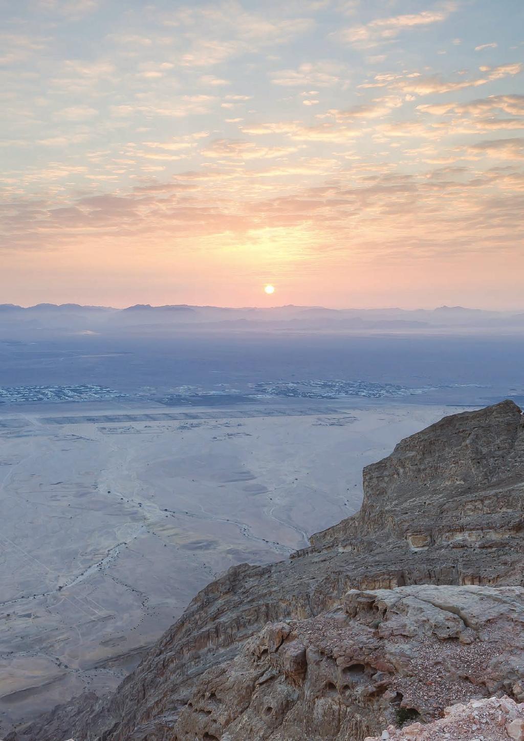
2 FIELD TRIP ENGINEERING FEATURES OF THE LIMESTONE BEDROCKS OF AL-AIN, UAE N Al-Ain U A E OMAN Date of the field tour: Thursday 19th November, 2015 Kilometers Time: 8:30 a.m. 3 p.m Place of Departure:. El Maqam University Campus, Crescent Building Aspects of the tour: Karstic cavities are common structural features in the limestone basement rocks of Abu Dhabi Emirate, especially in the Dammam and the overlying Asmari Formations in Al-Ain city. These cavities constitute hazards for the stability of building foundations. This tour will visit areas affected by karstic cavitation and also other more recent features of bedrock weathering. Tour guides: Professor Hasan Arman, Dr. Abdel-Rahman Fowler and Dr. Osman Abdelghany Field tour: Al-Ain Area, Jabal Mundassa, Jabal Hafit Lunch arrangements: 1:30 2:30 p.m. at the Mercure Hotel, Summit of Jabal Hafit.


 and faults.")
3 TOUR ITINERARY Stop 1 At Jabal Mundassa we will examine the coarse-grained fossiliferous bioclastic limestones of the Upper Cretaceous Simsima Formation, which have intensely developed fracturing described as stylolitic (dissolution along cracks by stress-increased solubility), veining (calcite healed opened cracks) and faults. Diversity of fractures in the Simsima Formation at Jabal Mundassa


 weathering")


4 Stop 2 Sinkholes and other karstic features of the Dammam and Asmari limestone formations will be viewed near Mazyad on the eastern side of Jabal Hafit. In addition, the limestones in this area show recent surface cavitation (honeycomb) weathering related to wind and salt effects in an arid climate. Soluble gypsum/anhydrite is an important component of rocks in the Al-Ain area. Karst dissolution leading to sinkholes in Asmari limestone Honeycomb weathering in Dammam and limestone Gypsum/Anhydrite bed rock

5 Stop 3 Road cutting along the eastern limb of Jabal Hafit. The beds here are steeply dipping fossiliferous limestones and soft marls of the Middle to Upper Eocene Dammam Formation. There are numerous fault structures and fibrous gypsum veins. The beds here apparently slipped over each other during the folding of the Hafit Anticline. Fault striations


6 Stop 4 At the Al Mubazara area (foot of Jabal Hafit) we pass through Middle Eocene nummulitic limestones and into the deepest unit in the Hafit Anticline the Lower Eocene Rus Formation. This formation consists of fine-grained nodular structured limestones and limestones with chert nodules. A major strike-slip fault cuts through Lower-Middle Eocene rocks and may have been a conduit for hot spring waters in the past. Large white chert nodule in dolomitized Rus Formation limestonet Dissolution cavities related to dolomitization Chert nodules parallel to bedding Sparry calcite cavity
7 GEOLOGY OF AL-AIN AREA 1. Introduction Al-Ain city is located at the eastern limit of Abu Dhabi Emirate, near the international border with the Sultanate of Oman. Al-Ain and Buraimi together form one of the largest oases in the Arabian Peninsula, due to a plentiful supply of surface and subsurface water draining from the Oman Mountains to the east. Al-Ain area is surrounded by three main geomorphological provinces (El-Ghawaby and El-Sayed, 1996): 1) Al Jaww piedmont plain of the Oman Mountains to the east, 2) the hilly area where bedrocks crop out to the southeast, and 3) the dune covered scarps to the north and south. Jabal Hafit and other mounts of Al-Ain area form conspicous geological features. For example, Jabals Auha, Huwayyah, Malaqet and Mundassah are foothills of the northern Oman Mountains. Older rocks are exposed in the core of a major anticline running through these mountains, while Jabal Hafit represents the younger sequence of Tertiary age. Geologic Map of Jabals: Hafit, Malaqet and Mundassa area (modified after Styles et al., 2006) 2. Jabal Hafit 2.1. Location and importance Jabal Hafit is located to the south-east of Al-Ain city (Lat to N and Long to E). It is considered as one of the most prominent features of the city. It is bounded to the north by Al-Ain city, to the east by Al-Jaww plain, to the south east by Mazyad, to the south by Oman and to the west by Ain Al Faydah resort and Zakher suburb. Ain Al Faydah is a monumental area nearby Jabal Hafit and located to the west of it. It is believed that the source of its famous hot springs is situated under Jabal Hafit Geology Jabal Hafit is about 29 km long, 5 km wide and reaches an elevation of 1240 m above sea level. The mountain has a whaleback appearance, with beds moderately to steeply dipping to the east and west on both limbs. Wadis on the flanks of the fold have produced deeply incised steep gul-

8 lies. The core of the mountain exposes a succession of erosion-resistant limestones and dolomites comprising the Rus Formation. Softer marls dominate the main parts of the overlying Dammam Formation. The deeper erosion of these marls has led to the development of two wadis parallel to the axis of the mountain: Wadi Tarabat to the east and Wadi Al Nahayan to the west. The next overlying formation is the Asmari Formation. This unit crops out as low hills of marls interrupted by sharp ridges of resistant limestone beds. Higher formations are very poorly exposed due to their high content of gypsiferous mudstones. Simplified stratigraphic section of Jabals: Malaqet - Mundassa and Hafit

9 Detailed map of Jabal Hafit modified by Abdelghany, 2002.
 that quickly subsided allowing deposition of gravels and shallow marine carbonate rocks composed of calcite and")


10 Geological History of the Al-Ain region More than 100 million years ago the Arabian Gulf area was occupied by a broad ocean named Neo-Tethys. The partial closing of this ocean produced a low mountain range (paleo-oman Mountains) that quickly subsided allowing deposition of gravels and shallow marine carbonate rocks composed of calcite and dolomite. These older carbonates were followed in the Eocene by larger thicknesses of younger limestones (with muddy interbeds) that form Jabal Hafit Mountain (about 1240 m above sea level). Later tectonic movements related to collision of Arabia with Iran in the Miocene caused folding of the Eocene limestones. Jabal Hafit itself is a single large fold, and shows many other structures like joints and faults. Hafit Mountain provides a good stratigraphic model for the Eocene and is the best local example of later tectonic structures. From the geologic point of view, but also from the tourism perspective. Abundant attractive fossils can be collected from the limestones, e.g. Nummulites and Assilina, which are similar in size and shape to an Emirates one-dirham coin. These are ancient unicellular organisms. There are also other fossils including echinoids, bivalves, gastropods, bryozoa, corals (solitary and colonial ones) and calcareous red algae. All of these fossils contribute to understanding the geological age and the nature of the marine environments and ancient paleogeography of this area. Hasan Arman is a Professor at Geology Department, College of Science, United Arab Emirates University since August He received his undergraduate degree from Hacettepe University, Turkey in 1984 and his Ph.D. degree from University of Arizona, USA in From 1992 to 1993, he was a Postdoc at the University of Nevada, Reno, USA. Between 1993 and 2008, he was a faculty member at Sakarya University, Civil Engineering Department, Turkey as Assistant and Associated Professor. He became a Professor at the same university in Dr. Arman has been teaching several different courses in undergraduate and graduate levels related to geology, environment, engineering and energy. His research interests include soil and rock mechanics, environmental geology, environmental degradation, water resources, global warming, climate change, renewable and sustainable energy sources. Dr. Arman s publications have appeared in different peer reviewed journals and he is an editorial board member in several international journals, also acting as a scientific reviewer in many others. Abdel-Rahman Fowler completed B.Sc. degree in Geology with honors in Mineralogy at Sydney University, His PhD degree was awarded at the University of New South Wales, Sydney, Australia in 1986 with thesis based on Structural Geology and Tectonics. obtained his Ph.D. He is currently Associate Professor of Structural Geology and Tectonics in the Geology Department at the United Arab Emirates University. Society affiliations include the Geological Society of Australia, International Association of Structural and Tectonic Geologists, Specialist Group in Tectonics and Structural Geology, and Australian Institute of Geoscientists. Dr. Abdel-Rahman is particularly interested in Arabian-Nubian Shield evolution and has published papers in national and international journals on this topic. Osman Abdelghany he received his B.Sc. in Geology with honors and M.Sc. in Stratigraphy and Micropaleontology from Ain Shams University, Cairo, Egypt respectively. He obtained his Ph.D. in 1996 from Vienna University, Austria. He is currently Associate Professor of Stratigraphy and Micropaleontology at United Arab Emirates University. Society affiliations include the ESG, GSA, GSE, ESP and ENHG. Dr. Osman is particularly interested in Cretaceous/Tertiary stratigraphy and microfossils and published a lot of papers in national and international magazines.
11
FIELD EXCURSION. 12 October 2017 AL AIN United Arab EmirateS. Engineering features of the limestone bedrocks of Al Ain
 ALL THE INFORMATION YOU NEED TO KNOW ABOUT THE 2017 ICEG FIELD EXCURSION 12 October 2017 AL AIN United Arab EmirateS Engineering features of the limestone bedrocks of Al Ain seg.org/events/iceg2017 AL
Stratigraphic Study of the Surface from Middle to Upper Eocene Dammam Formation, United Arab Emirates
 Stratigraphic Study of the Surface from Middle to Upper Eocene Dammam Formation, United Arab Emirates Khouya, S., Sheikh, F., Almuntaser, A., Aljabri, M., Abdelghany, O. and Abu Saima, M. United Arab Emirates
Groundwater level prediction at a pilot area in southeastern part of the UAE using Shallow Seismic Method
 Groundwater level prediction at a pilot area in southeastern part of the UAE using Shallow Seismic Method Murad A, Baker H, Mahmoud S, Gabr A Abstract The groundwater is one of the main sources for sustainability
ELECTRICAL RESISTIVITY IMAGING FOR QUATERNARY AQUIFER IN WADI MURAYKHAT AND WADI SA A, AL AIN AREA, UAE.
 ELECTRICAL RESISTIVITY IMAGING FOR QUATERNARY AQUIFER IN WADI MURAYKHAT AND WADI SA A, AL AIN AREA, UAE. By: Ahmed. El-Mahmoudi KFU University, Water Studies Centre, KSA Figure (#) Map of Al Jaww Plain
Assessment of Artificial Groundwater Recharge in Some Wadies in UAE by using Isotope Hydrology Techniques
 Assessment of Artificial Groundwater Recharge in Some Wadies in UAE by using Isotope Hydrology Techniques Presented by : Ahmed Saif Al Matri Head, Water Resources Section Ministry of Environment & Water
Groundwater Level Monitoring of the Quaternary Aquifer at Al Ain City, United Arab Emirates (UAE) using Geophysical Methods
 using Geophysical Methods") Groundwater Level Monitoring of the Quaternary Aquifer at Al Ain City, United Arab Emirates (UAE) using Geophysical Methods Ahmed Murad & Amir Gabr Geology Department UAE University Outlines Introduction
Groundwater Level Monitoring of the Quaternary Aquifer at Al Ain City, United Arab Emirates (UAE) using Geophysical Methods Ahmed Murad & Amir Gabr Geology Department UAE University Outlines Introduction
Isotope Stratigraphy of Oligocene Limestone in Al-Ain City, United Arab Emirates
 Arab J Sci Eng (2012) 37:1439 1449 DOI 10.1007/s13369-012-0253-y RESEARCH ARTICLE - EARTH SCIENCES Mohamed El Tokhi Hasan Arman Osman Abdelghany Waheed Hashem Ayman El Saiy Isotope Stratigraphy of Oligocene
EVALUATION OF GROUNDWATER QUALITY IN THE EASTERN DISTRICT OF ABU DHABI EMIRATE, UAE
 Proceedings of the 4 th International Conference on Environmental Science and Technology Rhodes, Greece, 3-5 September 05 EVALUATION OF GROUNDWATER QUALITY IN THE EASTERN DISTRICT OF ABU DHABI EMIRATE,
Module 10: Resources and Virginia Geology Topic 4 Content: Virginia Geology Notes
 Virginia is composed of a very diverse landscape that extends from the beaches and barrier islands all of the way to the highly elevated Appalachian Plateau. Geologists have discovered ancient shallow
Continental Landscapes
 Continental Landscapes Landscape influenced by tectonics, climate & differential weathering Most landforms developed within the last 2 million years System moves toward an equilibrium Continental Landscapes
CURRICULUM VITAE. - Postgraduate Level: 1- Advanced Macropaleontology, 2- Stratigraphy, 3- Advanced Paleoecology.
 CURRICULUM VITAE Name: Prof. Mohammed Gameil M. Sayed. Date of Birth: 23.07.1965. Nationality: Egyptian. Profession: Professor, Cairo Univ., Faculty of Sci., Geology Dept. Field of interest: Carbonate
Status of Quaternary aquifer sustainability at Umm Ghafa area, eastern part of Al-Ain area, UAE
 184 Trends and Sustainability of Groundwater in Highly Stressed Aquifers (Proc. of Symposium JS.2 at the Joint IAHS & IAH Convention, Hyderabad, India, September 2009). IAHS Publ. 329, 2009. Status of
Maine Geologic Facts and Localities October, Lobster Lake, Maine. Text by Robert G. Marvinney. Maine Geological Survey
 Maine Geologic Facts and Localities October, 1998 Lobster Lake, Maine 45 o 51 7.91 N, 69 o 30 53.88 W Text by Robert G. Marvinney, Department of Agriculture, Conservation & Forestry 1 Map by Introduction
The Welsh Borderland. Geologically recent surface deposits. The Welsh Borderland
 The Welsh Borderland This account provides a broad perspective of the geology of the Welsh Borderland region which comprises the southeast of Powys, southern Shropshire, northern Gwent, the western half
Terrain Units PALEOGEOGRAPHY: LANDFORM CREATION. Present Geology of NYS. Detailed Geologic Map of NYS
 NYS TOPOGRAPHY Why so? PALEOGEOGRAPHY: LANDFORM CREATION Prof. Anthony Grande AFG 014 Present Geology of NYS Detailed Geologic Map of NYS Generalized Geology Detailed Geology Hot links to the fold out
Sediment and sedimentary rocks Sediment
 Sediment and sedimentary rocks Sediment From sediments to sedimentary rocks (transportation, deposition, preservation and lithification) Types of sedimentary rocks (clastic, chemical and organic) Sedimentary
Landforms and Rock Structure
 Landforms and Rock Structure Rock Structure as a Landform Control Landforms of Horizontal Strata and Coastal Plains Landforms of Warped Rock Layers Landforms Developed on Other Land-Mass Types Landforms
Geomorphology Final Exam Study Guide
 Geomorphology Final Exam Study Guide Geologic Structures STRUCTURAL GEOLOGY concerned with shapes, arrangement, interrelationships of bedrock units & endogenic (within) forces that cause them. Tectonic
Holocene evolution of Dahab coastline Gulf of Aqaba, Sinai Peninsula, Egypt 1
 Holocene evolution of Dahab coastline Gulf of Aqaba, Sinai Peninsula, Egypt 1 Magdy Torab* 2 * Prof. of Geomorphology, Department of Geography, Damanhour University, Egypt 3 E-mail: magdytorab@hotmail.com.
Announcing a New Field-trip Seminar (TarT-7)
") Announcing a New Field-trip Seminar (TarT-7) Date: 28 November 2018 Starts & Ends at: Al-Nawras Hotel, Dubai, UAE Instructor: Dr. Mohammad Warrak, PhD. Organised by: Target Exploration Consultants Page
Announcing a New Field-trip Seminar (TarT-7) Date: 28 November 2018 Starts & Ends at: Al-Nawras Hotel, Dubai, UAE Instructor: Dr. Mohammad Warrak, PhD. Organised by: Target Exploration Consultants Page
UNIT 4 SEDIMENTARY ROCKS
 UNIT 4 SEDIMENTARY ROCKS WHAT ARE SEDIMENTS Sediments are loose Earth materials (unconsolidated materials) such as sand which are transported by the action of water, wind, glacial ice and gravity. These
Intra-symposium field trip to Torcal de Antequera and Alta Cadena Karst systems
 Intra-symposium field trip to Torcal de Antequera and Alta Cadena Karst systems Key features Departure: Wednesday 15 th October (8.30 am) from Malaga city (Hotel Malaga Palacio) Return: Same day 15 th
GEOL 110. Sedimentary Layering. Geologic Structures (faults, joints, folds), Unconformities, Karst. Sedimentary Layering 9/23/17. Geologic Structures
, Unconformities, Karst. Sedimentary Layering 9/23/17. Geologic Structures") GEOL 110 Sedimentary Layering Geologic Structures (faults, joints, folds), Unconformities, Karst Layering = horizontal, continuous banding produced during sediment deposition Sedimentary Layering Geologic
GEOL 110 Sedimentary Layering Geologic Structures (faults, joints, folds), Unconformities, Karst Layering = horizontal, continuous banding produced during sediment deposition Sedimentary Layering Geologic
The Nature of Sedimentary Rocks
 The Nature of Sedimentary Rocks Sedimentary rocks are composed of: Fragments of other rocks Chemical precipitates Organic matter or biochemically produced materials The Nature of Sedimentary Rocks Sedimentary
Fossils and Geology of Litzsinger Road Ecology Center
 Fossils and Geology of Litzsinger Road Ecology Center Table of Content Key Terms 1 Key Terms 2 What you need to know Geologic Map of Missouri Geologic Time Chart More of what you need to know Digital map
mountain rivers fixed channel boundaries (bedrock banks and bed) high transport capacity low storage input output
 high transport capacity low storage input output") mountain rivers fixed channel boundaries (bedrock banks and bed) high transport capacity low storage input output strong interaction between streams & hillslopes Sediment Budgets for Mountain Rivers Little
mountain rivers fixed channel boundaries (bedrock banks and bed) high transport capacity low storage input output strong interaction between streams & hillslopes Sediment Budgets for Mountain Rivers Little
Thickness, Compositional and Textural Variability, and Genesis of El-Lajjun Oil Shale, Central Jordan
 Thickness, Compositional and Textural Variability, and Genesis of El-Lajjun Oil Shale, Central Jordan H Alnawafleh 1, D Large 2 & B Spiro 3 1 Department of Mining Engineering, Al-Hussein Bin Talal University,
The Mesozoic. Wednesday, November 30, 11
 The Mesozoic Periods of the Mesozoic Triassic- First period of the Mesozoic era Jurassic Cretaceous- Last period of the Mesozoic era Breakup of Pangaea Stage one (Triassic) Rifting and volcanism, normal
Engineering Geology ECIV 2204
 Engineering Geology ECIV 2204 Instructor : Dr. Jehad Hamad 2017-2016 Chapter (6) : Sedimentary Rocks Chapter 6: Sedimentary Rocks Chapter 6: Sedimentary Rocks Origin and nature of sedimentary rocks: Sedimentary
Lecture 9 faults, folds and mountain building
 Lecture 9 faults, folds and mountain building Rock deformation Deformation = all changes in size, shape, orientation, or position of a rock mass Structural geology is the study of rock deformation Deformation
PALEOGEOGRAPHY of NYS. Definitions GEOLOGIC PROCESSES. Faulting. Folding 9/6/2012. TOPOGRAPHIC RELIEF MAP of NYS GRADATIONAL TECTONIC
 TOPOGRAPHIC RELIEF MAP of NYS PALEOGEOGRAPHY of NYS Prof. Anthony Grande AFG 2012 Definitions GEOLOGIC PROCESSES Geography: study of people living on the surface of the earth. Geology: the scientific study
Coso Red Hill and Coso Playa field trip, Prof. Alessandro Grippo, Ph.D.
 HISTORICAL GEOLOGY fall 2016 Professor: Dr. Alessandro Grippo, Ph.D. FIELD TRIP REPORT: Friday, October 21, 2016: Coso Red Hill & Playa, Coso Junction CA YOUR NAME part 1: COSO RED HILL (you can sample
Lecture Outline Wednesday - Friday February 14-16, 2018
 Lecture Outline Wednesday - Friday February 14-16, 2018 Quiz 2 scheduled for Friday Feb 23 (Interlude B, Chapters 6,7) Questions? Chapter 6 Pages of the Past: Sedimentary Rocks Key Points for today Be
Structural Geology Lab. The Objectives are to gain experience
 Geology 2 Structural Geology Lab The Objectives are to gain experience 1. Drawing cross sections from information given on geologic maps. 2. Recognizing folds and naming their parts on stereoscopic air
Copyright McGraw-Hill Education. All rights reserved. No reproduction or distribution without the prior written consent of McGraw-Hill Education
 Copyright McGraw-Hill Education. All rights reserved. No reproduction or distribution without the prior written consent of McGraw-Hill Education Tibetan Plateau and Himalaya -southern Asia 11.00.a VE 10X
GEOLOGIC MAPS PART II
 EARTH AND ENVIRONMENT THROUGH TIME LABORATORY - EES 1005 LABORATORY FIVE GEOLOGIC MAPS PART II Introduction Geologic maps of orogenic belts are much more complex than maps of the stable interior. Just
NAME HOMEWORK ASSIGNMENT #3 MATERIAL COVERS CHAPTERS 8, 9, 10, 11
 NAME HOMEWORK ASSIGNMENT #3 MATERIAL OVERS HAPTERS 8, 9, 10, 11 Assignment is due the beginning of the class period on November 23, 2004. Answers for each chapter will be discussed in class, as Exam #3
STUDY GUIDE FOR MID-TERM EXAM KEY. Color, luster, cleavage, fracture, hardness, taste, smell, fluorescence, radioactivity, magnetism
 STUDY GUIDE FOR MID-TERM EXAM KEY 1. In which type of rock are fossils most likely to be found? Sedimentary Rocks 2. Which mineral is easily identified by smell? Sulfur 3. Which natural resource makes
Geology (Mellow) Hike, Santa Lucia Memorial Park February 16, I. Overview of Santa Lucia Range geology and tectonic history
 Hike, Santa Lucia Memorial Park February 16, I. Overview of Santa Lucia Range geology and tectonic history") Geology (Mellow) Hike, Santa Lucia Memorial Park February 16, 2015 I. Overview of Santa Lucia Range geology and tectonic history A. Basement Rocks 1. Salinian Block Rocks Sierra Nevada Type, continental
Geology (Mellow) Hike, Santa Lucia Memorial Park February 16, 2015 I. Overview of Santa Lucia Range geology and tectonic history A. Basement Rocks 1. Salinian Block Rocks Sierra Nevada Type, continental
DR. MOHAMED FOUAD ALY
 DR. MOHAMED FOUAD ALY 1. GENERAL CURRICULUM VITAE Name: Dr. MOHAMED FOUAD ALY Date and place of birth: 7/12/1959, Cairo, Egypt Citizenship: Arab Republic of Egypt Current Address: Geology Department, Faculty
Evaluation of Structural Geology of Jabal Omar
 International Journal of Engineering Research and Development e-issn: 2278-067X, p-issn: 2278-800X, www.ijerd.com Volume 11, Issue 01 (January 2015), PP.67-72 Dafalla Siddig Dafalla * and Ibrahim Abdel
GEOLOGY GL1 Foundation Unit
 Candidate Name Centre Number Candidate Number 2 General Certificate of Education Advanced Subsidiary/Advanced 451/01 GEOLOGY GL1 Foundation Unit P.M. THURSDAY, 10 January 2008 (1 hour) Examiner Question
Answers: Internal Processes and Structures (Isostasy)
") Answers: Internal Processes and Structures (Isostasy) 1. Analyse the adjustment of the crust to changes in loads associated with volcanism, mountain building, erosion, and glaciation by using the concept
Answers: Internal Processes and Structures (Isostasy) 1. Analyse the adjustment of the crust to changes in loads associated with volcanism, mountain building, erosion, and glaciation by using the concept
Gravel Transport Can Determine Late Flood Tectonics
 Chapter 23 Gravel Transport Can Determine Late Flood Tectonics The locations of all the quartzite gravel in the northwest states and adjacent Canada provide more information about the Flood than just reinforcing
Tanyard Creek Virtual Field Trip
 Tanyard Creek Virtual Field Trip NorthWest Arkansas Community College s GEOL 1114 Hybrid Instructor Dr. Wendi J. Williams Student Team Members Cynthia Brantley Cassie Harris Jonathan Mooney David Selby
JOURNAL OF ENVIRONMENTAL HYDROLOGY
 JOURNAL OF ENVIRONMENTAL HYDROLOGY The Electronic Journal of the International Association for Environmental Hydrology On the World Wide Web at http://www.hydroweb.com VOLUME 13 2005 THE EFFECT OF SINKHOLES
Lab 7: Sedimentary Structures
 Name: Lab 7: Sedimentary Structures Sedimentary rocks account for a negligibly small fraction of Earth s mass, yet they are commonly encountered because the processes that form them are ubiquitous in the
Faults, folds and mountain building
 Faults, folds and mountain building Mountain belts Deformation Orogens (Oro = Greek all changes for mountain, in size, shape, genesis orientation, = Greek for or formation) position of a rock mass Structural
3. [ES 3] 1. [ST8.2] Some processes that shape Earth s surface are slow. Other processes are rapid. Which statement describes a rapid change?
![3. [ES 3] 1. [ST8.2] Some processes that shape Earth s surface are slow. Other processes are rapid. Which statement describes a rapid change?](/thumbs/89/98260180.jpg "3. [ES 3] 1. [ST8.2] Some processes that shape Earth s surface are slow. Other processes are rapid. Which statement describes a rapid change?") Science 8 SCIENCE QUARTERLY ASSESSMENT 2 3. [ES 3] S 1. [ST8.2] Some processes that shape Earth s surface are slow. Other processes are rapid. Which statement describes a rapid change? A. Glaciers melt
Science 8 SCIENCE QUARTERLY ASSESSMENT 2 3. [ES 3] S 1. [ST8.2] Some processes that shape Earth s surface are slow. Other processes are rapid. Which statement describes a rapid change? A. Glaciers melt
Geophysical investigation for shallow subsurface geotechnical problems for eastern part of 15P City, Cairo, Egypt.
 P May IJISET - International Journal of Innovative Science, Engineering & Technology, Vol. 3 Issue 7, July 2016 Geophysical investigation for shallow subsurface th geotechnical problems for eastern part
Instructor s Manual Chapter 3
 CHAPTER 3 Resource Integration Guide Chapter Outline Chapter Summary Lecture Suggestions Key Terms Web Links Virtual Field Trip Suggested Responses Chapter Outline 3.1 and the Rock Cycle 3.1a The Rock
Name: Period: Date: ID: A. Circle the choice that best completes the statement or answers the question and write the letter on the blank.
 Name: Period: _ Date: _ ID: A Unit 7 Practice Circle the choice that best completes the statement or answers the question and write the letter on the blank. 1. What term describes the movement of rock
Earth Science, (Tarbuck/Lutgens) Chapter 10: Mountain Building
 Chapter 10: Mountain Building") Earth Science, (Tarbuck/Lutgens) Chapter 10: Mountain Building 1) A(n) fault has little or no vertical movements of the two blocks. A) stick slip B) oblique slip C) strike slip D) dip slip 2) In a(n) fault,
Earth Science, (Tarbuck/Lutgens) Chapter 10: Mountain Building 1) A(n) fault has little or no vertical movements of the two blocks. A) stick slip B) oblique slip C) strike slip D) dip slip 2) In a(n) fault,
Geology of Landscapes Chapter 6 (Building Earth s Surface Faulting and Folding)
") Geology of Landscapes Chapter 6 (Building Earth s Surface Faulting and Folding) Process of _ that the earth s Stress and Strain Any solid material responds to a force in a way that depends on: pressure
Geology of Landscapes Chapter 6 (Building Earth s Surface Faulting and Folding) Process of _ that the earth s Stress and Strain Any solid material responds to a force in a way that depends on: pressure
Sedimentology & Stratigraphy. Thanks to Rob Viens for slides
 Sedimentology & Stratigraphy Thanks to Rob Viens for slides Sedimentology The study of the processes that erode, transport and deposit sediments Sedimentary Petrology The study of the characteristics and
Cattaraugus Creek: A Story of Flowing Water and the Geology of the Channel It Flows Through Presentation to West Valley Citizen Task Force 4/27/16
 Cattaraugus Creek: A Story of Flowing Water and the Geology of the Channel It Flows Through Presentation to West Valley Citizen Task Force 4/27/16 Raymond C. Vaughan, Ph.D. What happens if you drop a
Geologic Trips San Francisco and the Bay Area
 Excerpt from Geologic Trips San Francisco and the Bay Area by Ted Konigsmark ISBN 0-9661316-4-9 GeoPress All rights reserved. No part of this book may be reproduced without written permission in writing,
depression above scarp scarp
 1 LAB 1: FIELD TRIP TO McKINLEYVILLE AND MOUTH OF THE MAD RIVER OBJECTIVES: a. to look at geomorphic and geologic evidence for large scale thrust-faulting of young sediments in the Humboldt Bay region
Oceanography Field Trip One Key
 Oceanography Field Trip One Key If you are using this key as a make-up guide, you should get a COLOR version of this field trip guide by going to http://www.mpcfaculty.net/alfred_hochstaedter/oceanography.htm
Movement of the Earth s Crust: Formation of: Mountain s Plateau's and Dome s
 Movement of the Earth s Crust: Formation of: Mountain s Plateau's and Dome s References Information taken from several places including Prentice Hall Earth Science: @ http://www.eram.k12.ny.us/education/components/docmgr/default.php?sectiondetaili
Groundwater Sustainability at Wadi Al Bih Dam, Ras El Khaimah, United Arab Emirates (UAE) using Geophysical methods
 using Geophysical methods") Groundwater Sustainability at Wadi Al Bih Dam, Ras El Khaimah, United Arab Emirates (UAE) using Geophysical methods Ahmed Murad, Amir Gabr, Saber Mahmoud, Hasan Arman & Abdulla Al Dhuhoori Geology Department
Groundwater Sustainability at Wadi Al Bih Dam, Ras El Khaimah, United Arab Emirates (UAE) using Geophysical methods Ahmed Murad, Amir Gabr, Saber Mahmoud, Hasan Arman & Abdulla Al Dhuhoori Geology Department
12. The diagram below shows the collision of an oceanic plate and a continental plate.
 Review 1. Base your answer to the following question on the cross section below, which shows the boundary between two lithospheric plates. Point X is a location in the continental lithosphere. The depth
Florida s Karst Geology
 Florida s Karst Geology Orange Creek Basin Interagency Working Group Public Workshop, November 5 th, 2015 Harley Means, P.G. Assistant State Geologist Florida Geological Survey Karst Karst a type of topography
Chapter 3. Geology & Tectonics
 Chapter 3 Geology & Tectonics 3.1 Geology The general geological features of Indonesia are shown in Figure 3.1. The basement formation is metamorphic and it is intruded with plutonic formations. They are
Mammoth Cave National Park, Kentucky
 Mammoth Cave National Park, Kentucky Objectives of Today s Lecture Refresher on Sedimentary Depositional Systems and Rock Classifications Transgressive and Regressive Marine Environments Carbonate Depositional
3. The diagram below shows how scientists think some of Earth's continents were joined together in the geologic past.
 1. The map below shows the present-day locations of South America and Africa. Remains of Mesosaurus, an extinct freshwater reptile, have been found in similarly aged bedrock formed from lake sediments
INTRODUCTION TO STRATIGRAPHY
 EPSC 240: GEOLOGY IN THE FIELD INTRODUCTION TO STRATIGRAPHY with material from: Huan Cui (UMD) McGill University Earth and Planetary Sciences/Earth System Sciences ANNOUNCEMENT: First year field trip September
A Geological Tour of Tumbledown Mountain, Maine
 Maine Geologic Facts and Localities April, 1998 A Geological Tour of Tumbledown Mountain, Maine 44 45 3.21 N, 70 32 50.24 W Text by Robert G. Marvinney, Department of Agriculture, Conservation & Forestry
GEOL.3250 Geology for Engineers Sedimentary & Metamorphic Rocks
 GEOL.3250 Geology for Engineers Sedimentary & Metamorphic Rocks Name I. Introduction The bulk of the earth's crust is composed of relatively few minerals. These can be mixed together, however, to give
Module 9 Sedimentary Rocks
 Module 9 Sedimentary Rocks SEDIMENTARY ROCKS Rocks formed from material derived from preexisting rocks by surfacial processes followed by diagenesis There are two main classes of sedimentary rocks Clastic
Blocks Module Content Guide
 Blocks Module Content Guide This guide covers the basics of the content within the Interactive 3D Geologic Blocks Module. The content guide is intended to assist you, the teacher, in creating effective
Soils, Hydrogeology, and Aquifer Properties. Philip B. Bedient 2006 Rice University
 Soils, Hydrogeology, and Aquifer Properties Philip B. Bedient 2006 Rice University Charbeneau, 2000. Basin Hydrologic Cycle Global Water Supply Distribution 3% of earth s water is fresh - 97% oceans 1%
Sediment and Sedimentary rock
 Sediment and Sedimentary rock Sediment: An accumulation of loose mineral grains, such as boulders, pebbles, sand, silt or mud, which are not cemented together. Mechanical and chemical weathering produces
454/01 GEOLOGY GL4 EXTENSION GEOLOGY. P.M. FRIDAY, 14 June (2 Hours)
") WELSH JOINT EDUCATION COMMITTEE General Certificate of Education Advanced CYD-BWYLLGOR ADDYSG CYMRU Tystysgrif Addysg Gyffredinol Uwch 454/01 GEOLOGY GL4 EXTENSION GEOLOGY P.M. FRIDAY, 14 June 2002 (2
WELSH JOINT EDUCATION COMMITTEE General Certificate of Education Advanced CYD-BWYLLGOR ADDYSG CYMRU Tystysgrif Addysg Gyffredinol Uwch 454/01 GEOLOGY GL4 EXTENSION GEOLOGY P.M. FRIDAY, 14 June 2002 (2
GEOLOGY MEDIA SUITE Chapter 5
 UNDERSTANDING EARTH, SIXTH EDITION GROTZINGER JORDAN GEOLOGY MEDIA SUITE Chapter 5 Sedimentation Rocks Formed by Surface Processes 2010 W.H. Freeman and Company Mineralogy of sandstones Key Figure 5.12
2013 GEOLOGICAL ASSESSMENT REPORT SHERIDAN HILL PROPERTY
 2013 GEOLOGICAL ASSESSMENT REPORT ON THE SHERIDAN HILL PROPERTY NEW WESTMINSTER MINING DIVISION BRITISH COLUMBIA NTS 092G07 49 16 31 NORTH LATITUDE, 122 39 48 WEST LONGITUDE PREPARED FOR Sheridan Hill
Geologic Structures. Changes in the shape and/or orientation of rocks in response to applied stress
 Geologic Structures Changes in the shape and/or orientation of rocks in response to applied stress Figure 15.19 Can be as big as a breadbox Or much bigger than a breadbox Three basic types Fractures >>>
Plate Tectonics Tutoiral. Questions. Teacher: Mrs. Zimmerman. Plate Tectonics and Mountains Practice Test
 Teacher: Mrs. Zimmerman Print Close Plate Tectonics and Mountains Practice Test Plate Tectonics Tutoiral URL: http://www.hartrao.ac.za/geodesy/tectonics.html Questions 1. Fossils of organisms that lived
Variations in the Rus Formation
 Variations in the Rus Formation The Need for Consistent Core Logging Sallie Vest Halcrow / CH2M Hill 7 Nov 2012- TIME Not exposed at ground surface Umm Er- Raduh ma Paleogen e Eocene Damma m Cenozoic Oligoce
INTRODUCTION. Climate
 INTRODUCTION Climate Landslides are serious natural disasters in many parts of the world. Since the past 30 years, rainfall triggered landslides and debris flows had been one of the natural disasters of
Page 1. Name:
 Name: 1) Which property would best distinguish sediment deposited by a river from sediment deposited by a glacier? thickness of sediment layers age of fossils found in the sediment mineral composition
Australian Planation Surfaces
 Chapter 43 Australian Planation Surfaces Planation surfaces are more common and much easier to recognize in Africa and Australia than on the other continents. 1 Australia represents one huge planation
Geology 229 Engineering Geology. Lecture 6. Basic Rock Classification and Engineering Considerations (West, Chs. 2, 3, 4, 5)
") Geology 229 Engineering Geology Lecture 6 Basic Rock Classification and Engineering Considerations (West, Chs. 2, 3, 4, 5) Outline of this Lecture 1. Rock types and rock cycle 2. Geological and engineering
Geology 229 Engineering Geology Lecture 6 Basic Rock Classification and Engineering Considerations (West, Chs. 2, 3, 4, 5) Outline of this Lecture 1. Rock types and rock cycle 2. Geological and engineering
Chapter 6 Pages of Earth s Past: Sedimentary Rocks
 Chapter 6 Pages of Earth s Past: Sedimentary Rocks Introduction! Drilling into the bottom of the North Sea, we encounter: " Soft mud and loose sand, silt, pebbles, and shells. Then: " Similar materials
A) B) C) D) 4. Which diagram below best represents the pattern of magnetic orientation in the seafloor on the west (left) side of the ocean ridge?
 B) C) D) 4. Which diagram below best represents the pattern of magnetic orientation in the seafloor on the west (left) side of the ocean ridge?") 1. Crustal formation, which may cause the widening of an ocean, is most likely occurring at the boundary between the A) African Plate and the Eurasian Plate B) Pacific Plate and the Philippine Plate C)
1. Crustal formation, which may cause the widening of an ocean, is most likely occurring at the boundary between the A) African Plate and the Eurasian Plate B) Pacific Plate and the Philippine Plate C)
Structural Geology of the Mountains
 Structural Geology of the Mountains Clinton R. Tippett Shell Canada Limited, Calgary, Alberta clinton.tippett@shell.ca INTRODUCTION The Southern Rocky Mountains of Canada (Figure 1) are made up of several
Crags, Cracks, and Crumples: Crustal Deformation and Mountain Building
 Crags, Cracks, and Crumples: Crustal Deformation and Mountain Building Updated by: Rick Oches, Professor of Geology & Environmental Sciences Bentley University Waltham, Massachusetts Based on slides prepared
NORTH OF TEHRAN SITE EFFECT MICROZONATION
 13 th World Conference on Earthquake Engineering Vancouver, B.C., Canada August 1-6, 2004 Paper No. 3423 NORTH OF TEHRAN SITE EFFECT MICROZONATION M.K. Jafari 1, M.Kamalian 2, A.Razmkhah 3, A.Sohrabi 4
Structural Features and Fracture Orientation similarities between outcrops of the Ridgeley Sandstone
 The JUNIATA JOURNAL of GEOLOGY, 1, 1-8 (2014) Original article Structural Features and Fracture Orientation similarities between outcrops of the Ridgeley Sandstone Robert W. Baronner Two outcrops of the
Your web browser (Safari 7) is out of date. For more security, comfort and the best experience on this site: Update your browser Ignore
 is out of date. For more security, comfort and the best experience on this site: Update your browser Ignore") Your web browser (Safari 7) is out of date. For more security, comfort and the best experience on this site: Update your browser Ignore BEDRO CK For the complete encyclopedic entry with media resources,
Your web browser (Safari 7) is out of date. For more security, comfort and the best experience on this site: Update your browser Ignore BEDRO CK For the complete encyclopedic entry with media resources,
Landscape evolution. An Anthropic landscape is the landscape modified by humans for their activities and life
 Landforms Landscape evolution A Natural landscape is the original landscape that exists before it is acted upon by human culture. An Anthropic landscape is the landscape modified by humans for their activities
Cretaceous, Dakota Formation, Terra Cotta Member South Side of I-70, Salina County, Kansas
 Cretaceous, Dakota Formation, Terra Cotta Member South Side of I-70, Salina County, Kansas Written By: Steven D.J. Baumann G-102010-1A Outcrop looking southeast Photo taken by: Steven Baumann on 10-20-2010
Land subsidence due to groundwater withdrawal in Hanoi, Vietnam
 Land Subsidence (Proceedings of the Fifth International Symposium on Land Subsidence, The Hague, October 1995). 1AHS Publ. no. 234, 1995. 55 Land subsidence due to groundwater withdrawal in Hanoi, Vietnam
December 21, Chapter 11 mountain building E.notebook. Feb 19 8:19 AM. Feb 19 9:28 AM
 Mountains form along convergent plate boundaries. Typically (usually) if you look at a mountain range, you know that it is at a plate boundary (active continental margin) or has been some time in the past
The Indian Ocean. Copyright 2010 LessonSnips
 The Indian Ocean One of the five major geographic divisions of the world s ocean, the Indian Ocean is located in the Eastern Hemisphere. The Indian Ocean is bounded by three continents: Africa to the west,
Why is quartz one of the most weathering-resistant minerals?
 Why is it a poor idea to use limestone for tombstones in a wet hot area like the Amazon rainforest? A) Because limestone weathers at a very fast rate B) Because limestone weathers at a very low rate C)
KEY CHAPTER 12 TAKE-HOME QUIZ INTERNAL STRUCTURES AND PROCESSES Score Part B = / 55 PART B
 GEOLOGY 12 KEY CHAPTER 12 TAKE-HOME QUIZ INTERNAL STRUCTURES AND PROCESSES Score Part B = / 55 PART B CHAPTER 12 Isostacy and Structural Geology 1. Using the terms below, label the following diagrams and
Deformation of Rocks. Orientation of Deformed Rocks
 Deformation of Rocks Folds and faults are geologic structures caused by deformation. Structural geology is the study of the deformation of rocks and its effects. Fig. 7.1 Orientation of Deformed Rocks
DOMINANT SEDIMENTS TYPE IN ROCK Loose fragments of rocks or minerals broken off of bedrock Mineral crystals that precipitate directly out of water
 LAST NAME (ALL IN CAPS): FIRST NAME: 7. SEDIMENTARY PROCESSES, ROCKS, AND ENVIRONMENTS Instructions: Refer to Laboratory 6 in your Lab Book on pages 153-186 to answer the questions in this work sheet.
Vantage/Columbia Basin Field Trip
 Geology 152 Name Vantage/Columbia Basin Field Trip The primary goal of this course is to help you see the Earth from a different perspective a geological one. To accomplish this goal you will be expected