ELECTRICAL RESISTIVITY IMAGING FOR QUATERNARY AQUIFER IN WADI MURAYKHAT AND WADI SA A, AL AIN AREA, UAE.
|
|
|
- Marshall Henry
- 5 years ago
- Views:
Transcription


1 ELECTRICAL RESISTIVITY IMAGING FOR QUATERNARY AQUIFER IN WADI MURAYKHAT AND WADI SA A, AL AIN AREA, UAE. By: Ahmed. El-Mahmoudi KFU University, Water Studies Centre, KSA


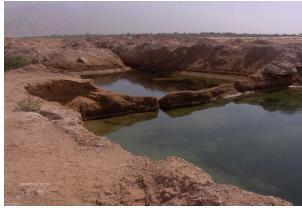
2 Figure (#) Map of Al Jaww Plain and locations of Wadi Muraykhat and Wadi Sa a (modified from Warrak, 1986).

3 Objectives These wadis originate from the Oman Mountains range and form the catchment and feeding area of the water resources. So, From the hydrogeological point of view, subsurface investigation of these wadies is very important for better understanding of the Quaternary aquifer system. To Map the subsurface conditions of the Quaternary alluvial aquifer system at Wadi Muraykhat & Wadi Sa a, Al Jaww Plain through (2-D) electrical Resistivity tomography survey.

4 To achieve these Objectives Reviewing the Geology of study area. A series of data including: Borehole data Geophysical Investigations (2-D Resistivity, TEM Data
5 GEOLOGICAL ASPECTS
6 E E E E E E N N N A-Geomorphology N Northern Dunes N IV OMAN MOUNTAINS N N I N N AL AIN III II N Jabal Hafit I N AL JAWW PLAIN N IV N N Southern Dunes OMAN MOUNTAINS I N 10 km I. Mountain areas II. Piedmonts and alluvial plains III. Al Ain urban area IV. Sand dune area Northern sand dune area Southern sand dune area Roads E E E E
7

8 BIDA BINT SAUD N Wadi Towayya AL OHA B-Geological Map of the Study Area, showing the different rock units N Wadi Al Jimi Wadi Al Ain AL AIN Jabal Oha BUREIMI Jabal Huwayya Jabal Qatar Jabal Zarub Wadi Shik N Wadi Idan Wadi Muthaymimah Jabal Malaqet Jabal Muthaymimah Wadi Sa a Jabal Hafit Wadi Muraykhat N 5 km Quaternary alluvium Eocene and Paleocene rocks Thrust fault ~~~~~~ Unconformity ~~~~~~ Unconformity Road Upper For a Formation Simsima Formation Wadi Lower For a Formation ~~~~~~ Unconformity Geologic contact ~~~~~~ Unconformity S Nappe Formation Asmari Formation Thrust fault ~~~~~~ Unconformity Haybi Complex and Hawasina Series


9 C-Surface Lithologic units at Al Jaww Plain OMAN Al Jaww F Plain D F

10 D-Structure Setting Bouguer anomaly map of Al Jaww Plain showing gravity anomaly lows in the centre and gradual increase to the east of the survey area (After Ali et. al 2008).
11 Boundary of concession area (aaproximate) E E N N IQS E N OMAN MOUNTAINS E E N N IQS E N OMAN MOUNTAINS N N N N 10 km 10 km 25 IQS-18 IQS N N N N IQS-8 IQS N N N AL AIN IQS-11 AL AIN N N N Jabal Hafit IQS N 25 Mountains Reprocessed Seismic Line Primary Roads Ground water research project well Jabal Hafit AL JAWW PLAIN N IQS-8 Mountains Thrust Fault Reprocessed Seismic Line Primary Roads E E E AL JAWW PLAIN N E E E Amoco seismic lines and uphole-survey locations (after Woodward, 1994). Generalized subsurface structural features in Al Ain area (after Woodward, 1994).
12 WEST IQS ALTITUDE IN 280 METERS ABOVE SEA LEVEL LAND SURFACE DISTAL ANTICLINE Anticline F5b Syncline F2c EAST DEPTH BELOW DATUM OF 91.5 METERS ABOVE SEA LEVEL, IN SECONDS OF 2-WAY SEISMIC TRAVEL-TIME 1 2 SEISMIC REFLECTOR 1 2 IQS ALTITUDE IN 380 METERS ABOVE SEA LEVEL DEPTH BELOW DATUM OF 91.5 METERS ABOVE SEA LEVEL, IN SECONDS OF 2-WAY SEISMIC TRAVEL-TIME Syncline Anticline F F5b Interpreted seismic lines at Al Jaww Plain and north of Al Jaww Plain, (modified after Woodward, 1994). 2 2 IQS

13 Combined interpretation of the data, which is consistent with all available geological and geophysical data. The position of folds and reverse faults are shown. Also shown are the approximate positions of the Hawasina and S Ophiolite thrust fronts, (After Ali et. al 2008).
14 HYDROGEOLOGICAL ASPECTS
15 25 o 52 o 53 o 54 o 55 o 56 o Sha am LEGEND Northern limestone aquifer Ophiolite aquifer Eastern gravel aquifer Western gravel aquifer Sand dune aquifer Coastal sabkha Cultivated areas Main Cities A-Different Aquifers in N UAE. A r a b i a n G u l f Dubai Umm Al Qaiwin Ajman Sharjah Ras Al Khaimah Al Dhaid Al Shiuab Al Khatt Masafi Al Faiyah Al Madam OMAN Hatta Dibba Khor Fakkan Gulf of Oman Fujairah 25 o Kalba Dalma Bani Yas Abu Dhabi Al Hayer 24 o Jabal Dhanna Jabal Hafit Al Ain Al Jaww Plain 24 o Al Sih O M A N Madinat Zayed Al Wagan U N I T E D A R A B E M I R A T E S 23 o S A U D I Liwa 23 o A R A B I A 50 km 52 o 53 o 54 o 55 o 56 o
16 B- Geologic Framework of the Eastern Region of Abu Dhabi Emirate (after Bright, 1998) Age Quaternary Pliocene- Miocene Geologic Sequence Eolian Sand Alluvium Post-Fars Upper Fars Approximate Thickness (m) Hydrologic Unit Unsaturated overburden Surficial Aquifer system Eolian Sand Quaternary Alluvium Altered Tertiary Deposits Unaltered Tertiary Deposits Clastic Limestone Deep Limestone Miocene- Oligocene Paleocene- Eocene Cretaceous Lower Fars Fm. Asmari Fm. Dammam Fm. Rus Fm. Umm er-radhuma Fm. Simsima Fm. Qahlah Fm. Juweiza Fm ,200 3,000 Basal Confining system Pre-Tertiary Deposits
17 C-Quaternary Aquifer Geometry
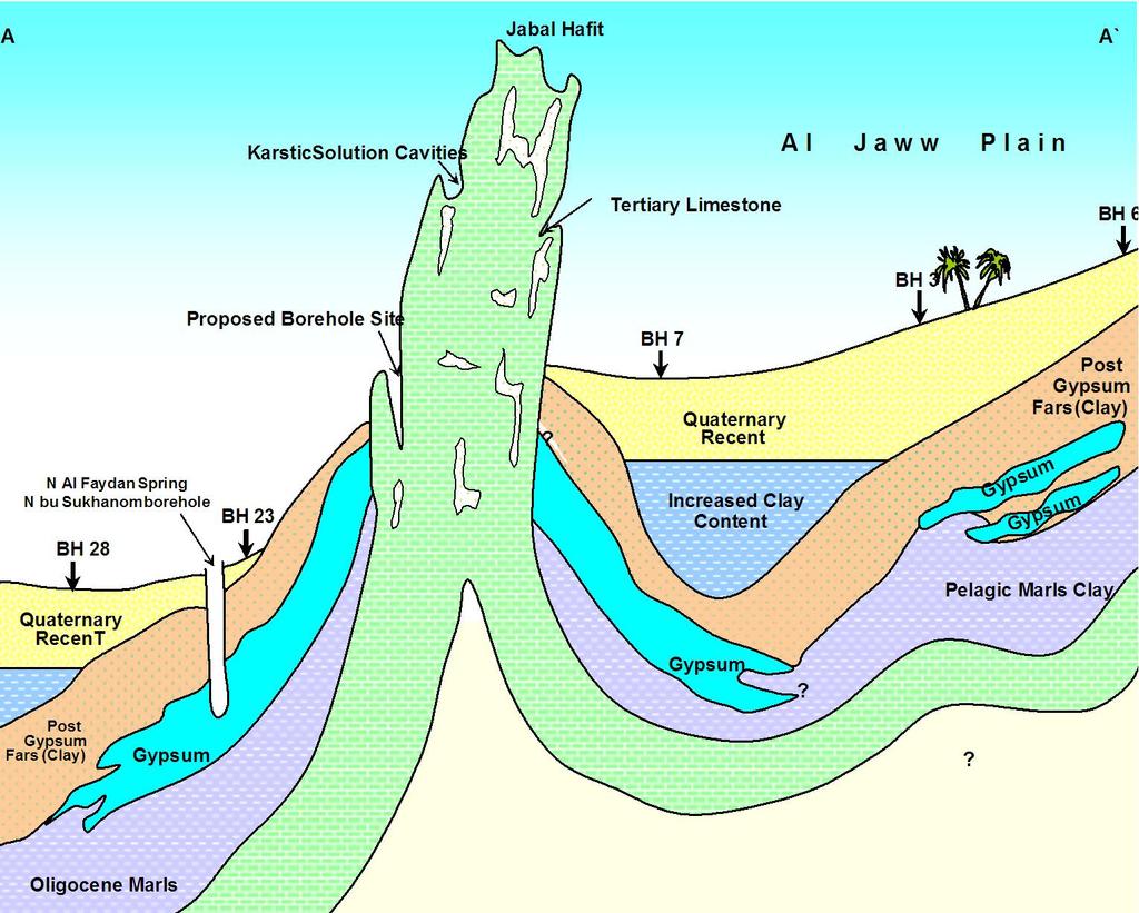
18
19 D-Flow System and water level assessment (After Al Nuaimi, 2003)
20 Geophysical Investigations

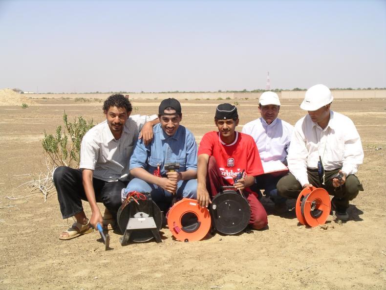
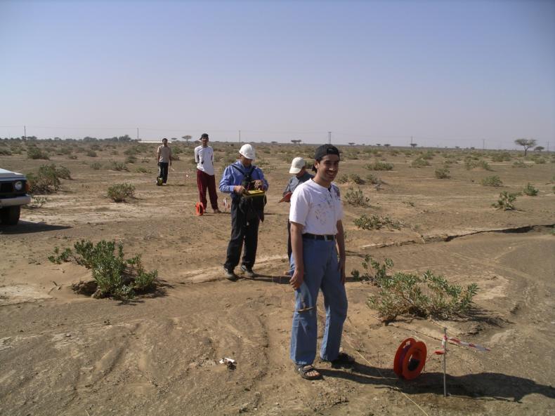
21 A-2-D Resistivity Data Acquisition
22 Base Map of 2-D Resistivity Profiles Well No.GWP Jabal Hafit 2` 1` 2 1 4` 4 3` ` 6` 7 8 7` 8` 13` 13 12`12 11` 11 10` 10 9` Legend Wells provided by WED Main Road 3 3`2-D Resistivity Profile

23 Typical TEM data from sounding Zarub-2-2 and Zarub Zarub-2-2 Zarub-2-11 The observed data and the model response Interpreted layer resistivity.

24 Base map showing the Electromagnetic survey at Al Qura'a area north of Al Ain (after US Geological Survey, 1993)
25 WSTA 8 Th Gulf Water Conference, 3-6 March , Manama, Bahrain DEPTH (m) Below land surface LITHOLOGY RESISTIVITY (Ohm.meters) Resistivity model of typical resistivities for interdune soundings at Al Qura a, north of Al Ain (after US Geological survey, 1993). DESCRIPTION , R1: Surface resistive layer (aeolian sand and alluvium, dry) C1: Upper conductive layer (mostly clay and silt) R2: Upper resistive layer (alluvial sand and gravel; possible calcareous cement) R3: Primary resistive layer (alluvial sand and gravel; good permeability; fresh water where saturated) C2: Conductive layer (mostly clay and silt) C3: Conductive layer (mostly clay and mudstone; poor water quality)
26 Depth (meters) GWP sand & gravel 20 sand & gravel calcareously cemented sand gravelly clay 60 clay Resistivity (ohm-m) 1000 Well GWP-18 log information. The solid and dashed lines) green &red) are the deep and medium induction logs. The heavy line (Blue) is the blocked resistivity model based upon the induction logs. Layer lithology is shown (After Fitterman, et al.1991).

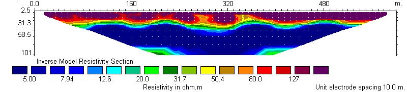
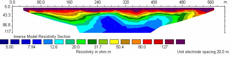
27 2 2` 6 6` 12 12`
 2-D Resistivity profile along")

28 Gravel and sand zone of moderate resistivity Paleo channel Surface resistive layer (Dry alluvium) 1 1` Conductive Layer (Clay & Mudstone Conductive Layer (Clay & Mudstone Figure (#) 2-D Resistivity profile along line 1-1` 11 Gravel and sand zone Of moderate resistivity Paleo channel Surface resistive layer (Dry alluvium) 11` Conductive Layer (Clay & Mudstone Conductive Layer (Clay & Mudstone Figure (#) 2-D Resistivity profile along line 11-11`
 profiles.")
29 Conclusions 2-D resistivity tomograms of the Thirteen profiles indicate clearly the different hydrostratigraphic units of Quaternary aquifer along the eastern margin of Al Jaww plain Erosional unconformities at the base of the Quaternary alluvium are traced along some of the (2-D) profiles. These unconformities represent the paleochannels in the bed rock that were formed in the geological past by the ancient wadies. These paleochannels are promising targets for fresh groundwater, as they contain appreciable thickness of water-bearing formations that are recharged from the surrounding mountain region. ( Channel Deposits serve as both storage reservoirs and recharge zones for the shallow aquifer system in Al Jaww Plain. This contribution will provide the technical support for planners, decision makers, and researchers in the field of groundwater development and management. Especially, Now days Aquifer Storage and Recovery system (ASR) Projects are implemented in Al Ain area and elsewhere at UAE.
30 Thank You For your attention
Assessment of Artificial Groundwater Recharge in Some Wadies in UAE by using Isotope Hydrology Techniques
 Assessment of Artificial Groundwater Recharge in Some Wadies in UAE by using Isotope Hydrology Techniques Presented by : Ahmed Saif Al Matri Head, Water Resources Section Ministry of Environment & Water
Groundwater Level Monitoring of the Quaternary Aquifer at Al Ain City, United Arab Emirates (UAE) using Geophysical Methods
 using Geophysical Methods") Groundwater Level Monitoring of the Quaternary Aquifer at Al Ain City, United Arab Emirates (UAE) using Geophysical Methods Ahmed Murad & Amir Gabr Geology Department UAE University Outlines Introduction
Groundwater Level Monitoring of the Quaternary Aquifer at Al Ain City, United Arab Emirates (UAE) using Geophysical Methods Ahmed Murad & Amir Gabr Geology Department UAE University Outlines Introduction
Groundwater level prediction at a pilot area in southeastern part of the UAE using Shallow Seismic Method
 Groundwater level prediction at a pilot area in southeastern part of the UAE using Shallow Seismic Method Murad A, Baker H, Mahmoud S, Gabr A Abstract The groundwater is one of the main sources for sustainability
EVALUATION OF GROUNDWATER QUALITY IN THE EASTERN DISTRICT OF ABU DHABI EMIRATE, UAE
 Proceedings of the 4 th International Conference on Environmental Science and Technology Rhodes, Greece, 3-5 September 05 EVALUATION OF GROUNDWATER QUALITY IN THE EASTERN DISTRICT OF ABU DHABI EMIRATE,
Groundwater Sustainability at Wadi Al Bih Dam, Ras El Khaimah, United Arab Emirates (UAE) using Geophysical methods
 using Geophysical methods") Groundwater Sustainability at Wadi Al Bih Dam, Ras El Khaimah, United Arab Emirates (UAE) using Geophysical methods Ahmed Murad, Amir Gabr, Saber Mahmoud, Hasan Arman & Abdulla Al Dhuhoori Geology Department
Groundwater Sustainability at Wadi Al Bih Dam, Ras El Khaimah, United Arab Emirates (UAE) using Geophysical methods Ahmed Murad, Amir Gabr, Saber Mahmoud, Hasan Arman & Abdulla Al Dhuhoori Geology Department
Stratigraphic Study of the Surface from Middle to Upper Eocene Dammam Formation, United Arab Emirates
 Stratigraphic Study of the Surface from Middle to Upper Eocene Dammam Formation, United Arab Emirates Khouya, S., Sheikh, F., Almuntaser, A., Aljabri, M., Abdelghany, O. and Abu Saima, M. United Arab Emirates
Status of Quaternary aquifer sustainability at Umm Ghafa area, eastern part of Al-Ain area, UAE
 184 Trends and Sustainability of Groundwater in Highly Stressed Aquifers (Proc. of Symposium JS.2 at the Joint IAHS & IAH Convention, Hyderabad, India, September 2009). IAHS Publ. 329, 2009. Status of
15 18 November Al Ain, UAE
 15 18 November Al Ain, UAE WWW. FIELD TRIP ENGINEERING FEATURES OF THE LIMESTONE BEDROCKS OF AL-AIN, UAE N Al-Ain 0 4 3 1 U A E OMAN 0 5 10 15 Date of the field tour: Thursday 19th November, 2015 Kilometers
Water Resources of Saudi Arabia
 Water Resources of Saudi Arabia Resources of Saudi Arabia 1 Water Resources of Saudi Arabia Water Supply in KSA Surface water (48-10%) Groundwater (49-80% @ 70m- 1000m depth) Desalinated water (3-6%) Reclaimed
Geographical Information System Modeling of Groundwater Potentiality in the Northeastern Part of the United Arab Emirates
 Geographical Information System Modeling of Groundwater Potentiality in the ortheastern Part of the United Arab Emirates Z.S. RIZK Institute of Environment and Water, Ajman University of Science & Technology,
Block 43B - Onshore Oman
 Block 43B - Onshore Oman SUMMARY Block 43B is an 11,967 km 2 area located along the coastal area of Oman north of the Hajar Mountains. This is an unexplored region, both geographically and stratigraphically.
Evolution of the conceptual hydrogeologic and ground-water flow model for Las Vegas Valley, Clark County, Nevada
 Evolution of the conceptual hydrogeologic and ground-water flow model for Las Vegas Valley, Clark County, Nevada Geological Society of America Annual Meeting November 14, 2 David J. Donovan Southern Nevada
Near-Surface Electromagnetic Surveying
 Near-Surface Electromagnetic Surveying The E&P industry typically focuses on deep formations, but frequently the nearsurface layers also need to be evaluated. Land-based electromagnetic surveys provide
DOI: / Page. 2 Department of Geophysics, Ain Shams University, Cairo, Egypt
 IOSR Journal of Applied Geology and Geophysics (IOSR-JAGG) e-issn: 2321 0990, p-issn: 2321 0982.Volume 3, Issue 6 Ver. III (Nov. - Dec. 2015), PP 34-45 www.iosrjournals.org Application of Two-Dimensional
FIELD EXCURSION. 12 October 2017 AL AIN United Arab EmirateS. Engineering features of the limestone bedrocks of Al Ain
 ALL THE INFORMATION YOU NEED TO KNOW ABOUT THE 2017 ICEG FIELD EXCURSION 12 October 2017 AL AIN United Arab EmirateS Engineering features of the limestone bedrocks of Al Ain seg.org/events/iceg2017 AL
RESISTIVITY IMAGING AND BOREHOLE INVESTIGATION OF THE BANTING AREA AQUIFER, SELANGOR, MALAYSIA. A.N. Ibrahim Z.Z.T. Harith M.N.M.
 JOURNAL OF ENVIRONMENTAL HYDROLOGY The Electronic Journal of the International Association for Environmental Hydrology On the World Wide Web at http://www.hydroweb.com VOLUME 11 2003 RESISTIVITY IMAGING
BALOCHISTAN FOLDBELT BASIN
 INTRODUCTION BALOCHISTAN FOLDBELT BASIN The Kharan-3 block is located in the Kharan Trough of Balochistan Basin. GEOLOGICAL SETTING The Balochistan Province is an Upper Cretaceous to Recent structurally
Soils, Hydrogeology, and Aquifer Properties. Philip B. Bedient 2006 Rice University
 Soils, Hydrogeology, and Aquifer Properties Philip B. Bedient 2006 Rice University Charbeneau, 2000. Basin Hydrologic Cycle Global Water Supply Distribution 3% of earth s water is fresh - 97% oceans 1%
Integrated Geophysical Interpretation On The Groundwater Aquifer (At The North Western Part of Sinai, Egypt)
") Integrated Geophysical Interpretation On The Groundwater Aquifer (At The North Western Part of Sinai, Egypt) Sultan Awad Sultan Araffa 1, Hassan S. Sabet 2, Ahmed M, Al Dabour 3 1 National Research Institute
Integrated Geophysical Interpretation On The Groundwater Aquifer (At The North Western Part of Sinai, Egypt) Sultan Awad Sultan Araffa 1, Hassan S. Sabet 2, Ahmed M, Al Dabour 3 1 National Research Institute
EVALUATION OF AQUIFER CHARACTERISTICS FOR SELECTED NEW METHOD OF THE UM RUWABA FORMATION: NORTH KORDOFAN STATE, SUDAN
 EVALUATION OF AQUIFER CHARACTERISTICS FOR SELECTED NEW METHOD OF THE UM RUWABA FORMATION: NORTH KORDOFAN STATE, SUDAN ELHAGA.B *1; ELZIENS.M*2 ANDLISSANN.H*3 *1Department of C i v i l E n g i n e e r i
The impact of geologic setting on the groundwater occurrence in the Eocene limestone of El Minia-East Nile-Egypt, using geoelectrical technique
 Available online at www.pelagiaresearchlibrary.com Advances in Applied Science Research, 2016, 7(4):257-273 ISSN: 0976-8610 CODEN (USA): AASRFC The impact of geologic setting on the groundwater occurrence
Does the SDCP need inputs from geology?
 The British Geological Survey s Experience and Expertise in Supporting Projects such as the Sirte Depression Connection Project David Ovadia Director of International Kingsley Dunham Centre Keyworth Nottingham
Announcing a New Field-trip Seminar (TarT-7)
") Announcing a New Field-trip Seminar (TarT-7) Date: 28 November 2018 Starts & Ends at: Al-Nawras Hotel, Dubai, UAE Instructor: Dr. Mohammad Warrak, PhD. Organised by: Target Exploration Consultants Page
Announcing a New Field-trip Seminar (TarT-7) Date: 28 November 2018 Starts & Ends at: Al-Nawras Hotel, Dubai, UAE Instructor: Dr. Mohammad Warrak, PhD. Organised by: Target Exploration Consultants Page
Variations in the Rus Formation
 Variations in the Rus Formation The Need for Consistent Core Logging Sallie Vest Halcrow / CH2M Hill 7 Nov 2012- TIME Not exposed at ground surface Umm Er- Raduh ma Paleogen e Eocene Damma m Cenozoic Oligoce
A.K. Khanna*, A.K. Verma, R.Dasgupta, & B.R.Bharali, Oil India Limited, Duliajan.
 P-92 Application of Spectral Decomposition for identification of Channel Sand Body in OIL s operational area in Upper Assam Shelf Basin, India - A Case study A.K. Khanna*, A.K. Verma, R.Dasgupta, & B.R.Bharali,
REGIONAL GEOLOGY IN KHMER BASIN
 CONTENTS 1-Khmere Basin 2-Regional Geology Khmer Basin 3-Regime Tectonic 4-Seismic Database -a/ Acquisition Data -b/ Prospect Angkor -C/ Cross Section Seismic 5-Play Type -a/ Play Schematic -b/ Structure
EGAS. Ministry of Petroleum
 EGAS Ministry of Petroleum EGAS Ministry of Petroleum About The Block Location: N. El Arish offshore block is located in the extreme eastern part of the Egypt s economic water border and bounded from the
Ministry of Oil and Minerals Petroleum Exploration & Production Authority BLOCK 85 (Al Uqlah North)
") Ministry of Oil and Minerals Petroleum Exploration & Production Authority BLOCK 85 (Al Uqlah North) The Al Uqlah North Block (85) occupies an area of 597 km 2 in the Sabatayn Basin in the province of Shabwah
Ministry of Oil and Minerals Petroleum Exploration & Production Authority BLOCK 85 (Al Uqlah North) The Al Uqlah North Block (85) occupies an area of 597 km 2 in the Sabatayn Basin in the province of Shabwah
Structural Style and Stratigraphy of the Huwayyah Anticline: an Example of an Al-Ain Tertiary Fold, Northern Oman Mountains
 GeoArabia, Vol. 5, No. 3, 2 Gulf PetroLink, Bahrain Huwayyah Anticline, Northern Oman Structural Style and Stratigraphy of the Huwayyah Anticline: an Example of an Al-Ain Tertiary Fold, Northern Oman Mountains
Assessment of Ground Water in a Part of Coastal West Bengal using Geo-Electrical Method
 Vol. 13, No. 2, pp. 203-210 (2013) Journal of Agricultural Physics ISSN 0973-032X http://www.agrophysics.in Research Article Assessment of Ground Water in a Part of Coastal West Bengal using Geo-Electrical
Investigating the source of thermal anomalies in the northern United Arab Emirates (UAE) desert using geophysical methods
 desert using geophysical methods") Scholars' Mine Doctoral Dissertations Student Research & Creative Works Summer 2010 Investigating the source of thermal anomalies in the northern United Arab Emirates (UAE) desert using geophysical methods
Scholars' Mine Doctoral Dissertations Student Research & Creative Works Summer 2010 Investigating the source of thermal anomalies in the northern United Arab Emirates (UAE) desert using geophysical methods
Electrical Resistivity Survey for Delineating Seawater Intrusion in a Coastal Aquifer
 Electrical Resistivity Survey for Delineating Seawater Intrusion in a Coastal Aquifer Sung-Ho Song*, Gyu-Sang Lee*, Jin-Sung Kim*, Baekuk Seong*, Young-gyu Kim*, Myung-Ha Woo* and Namsik Park** Abstract
Geophysical Evaluation for Evidence of Recharging the Pleistocene Aquifer at El-Nubariya Area, West Nile Delta, Egypt
 International Journal of Geosciences, 2014, 5, 324-340 Published Online March 2014 in SciRes. http://www.scirp.org/journal/ijg http://dx.doi.org/10.4236/ijg.2014.53032 Geophysical Evaluation for Evidence
EGAS. Ministry of Petroleum
 EGAS Ministry of Petroleum EGAS Ministry of Petroleum About The Block Location: N. Thekah offshore block is located at about 56 km to the north of the Mediterranean shore line, 85 km to the north west
APPLICATION OF ELECTRICAL RESISTIVITY TOMOGRAPHY FOR SAND UNDERWATER EXTRACTION
 International Scientific Conference GEOBALCANICA 2018 APPLICATION OF ELECTRICAL RESISTIVITY TOMOGRAPHY FOR SAND UNDERWATER EXTRACTION Maya Grigorova Ivaylo Koprev University of Mining and Geology St. Ivan
Development of geophysical investigation for verifying treatment efficiency of underground cavities
 Development of geophysical investigation for verifying treatment efficiency of underground cavities Hasan A. Kamal* Kuwait Institute for Scientific Research, Infrastructure Risk and Reliability Program,
Land subsidence due to groundwater withdrawal in Hanoi, Vietnam
 Land Subsidence (Proceedings of the Fifth International Symposium on Land Subsidence, The Hague, October 1995). 1AHS Publ. no. 234, 1995. 55 Land subsidence due to groundwater withdrawal in Hanoi, Vietnam
A Preliminary Geophysical Reconnaissance Mapping of Emirau Ground Water Resource, Emirau Island, New Ireland Province, PNG
 A Preliminary Geophysical Reconnaissance Mapping of Emirau Ground Water Resource, Emirau Island, New Ireland Province, PNG Geological Survey Division of Mineral Resources Authority (MRA) Papua New Guinea
Mineral investment opportunities in the UAE
 Mineral investment opportunities in the UAE Clive Mitchell Industrial Minerals Specialist British Geological Survey Outline of presentation Intro & BGS work in the UAE Ministry of Energy (MoE) UAE geology
JOURNAL OF ENVIRONMENTAL HYDROLOGY
 JOURNAL OF ENVIRONMENTAL HYDROLOGY The Electronic Journal of the International Association for Environmental Hydrology On the World Wide Web at http://www.hydroweb.com VOLUME 13 2005 THE EFFECT OF SINKHOLES
SEISMIC REFRACTION INVESTIGATION OF THE SUBSURFACE STRUCTURE AT THE SOUTHERN PART OF NIGER STATE COLLEGE OF EDUCATION, MINNA, NIGERIA
 Bayero Journal of Pure and Applied Sciences, 3(2): 56-6 Received: May, 200 Accepted: October, 200 ISSN 2006-6996 SEISMIC REFRACTION INVESTIGATION OF TE SUBSURFACE STRUCTURE AT TE SOUTERN PART OF NIGER
SECTION 4 TABLES. 1 Summary of Hydrogeologic Parameters for Various Stratigraphic Units FIGURES
 SECTION 4 4.0 OVERVIEW OF GEOLOGY AND HYDROGEOLOGY... 13 4.1 Comparison of East and West Sides of Study Area... 15 4.2 Bedrock Sequence... 17 4.3 Mancos Shale (Upper Cretaceous)... 18 4.4 Mesaverde Formation
PRELIMINARY. Select Geophysical Methods and Groundwater Modeling: Examples from USGS studies. Claudia Faunt and a cast of others
 Select Geophysical Methods and Groundwater Modeling: Examples from USGS studies Claudia Faunt and a cast of others Current Preliminary Studies Stanford Water in the West Groundwater Data Workshop Series:
RESISTIVITY IMAGING IN EASTERN NEVADA USING THE AUDIOMAGNETOTELLURIC METHOD FOR HYDROGEOLOGIC FRAMEWORK STUDIES. Abstract.
 RESISTIVITY IMAGING IN EASTERN NEVADA USING THE AUDIOMAGNETOTELLURIC METHOD FOR HYDROGEOLOGIC FRAMEWORK STUDIES Darcy K. McPhee, U.S. Geological Survey, Menlo Park, CA Louise Pellerin, Green Engineering,
Hydrocarbon Volumetric Analysis Using Seismic and Borehole Data over Umoru Field, Niger Delta-Nigeria
 International Journal of Geosciences, 2011, 2, 179-183 doi:10.4236/ijg.2011.22019 Published Online May 2011 (http://www.scirp.org/journal/ijg) Hydrocarbon Volumetric Analysis Using Seismic and Borehole
11/22/2010. Groundwater in Unconsolidated Deposits. Alluvial (fluvial) deposits. - consist of gravel, sand, silt and clay
 deposits. - consist of gravel, sand, silt and clay") Groundwater in Unconsolidated Deposits Alluvial (fluvial) deposits - consist of gravel, sand, silt and clay - laid down by physical processes in rivers and flood plains - major sources for water supplies
Groundwater in Unconsolidated Deposits Alluvial (fluvial) deposits - consist of gravel, sand, silt and clay - laid down by physical processes in rivers and flood plains - major sources for water supplies
42 Middle East Well Evaluation Review
 Analysis of waves passing through rocks is taking a new direction. Geophysicists, keen to maximize the benefits from seismic data, are gleaning fresh information about formations by analysing some of the
Chapter 8 Fetter, Applied Hydrology 4 th Edition, Geology of Groundwater Occurrence
 Chapter 8 Fetter, Applied Hydrology 4 th Edition, 2001 Geology of Groundwater Occurrence Figure 8.42. Alluvial Valleys ground-water region. Fetter, Applied Hydrology 4 th Edition, 2001 Fetter, Applied
TEMPERATURE GEOTHERMAL SYSTEM *.BY. Roger F. Harrison Salt Lake City, Utah. C; K. Blair
 - * f c * -6 9 -.I. lcal '. DEVELOPMENT AND TESTSNG OF A SMALL MODERATE TEMPERATURE GEOTHERMAL SYSTEM *.BY Roger F. Harrison Terra Tek, Inc. Salt Lake City, Utah C; K. Blair Terra Tek, Inc. - Salt Lake
Ministry of Oil and Minerals Petroleum Exploration & Production Authority BLOCK 80 (WADI SARR)
") Ministry of Oil and Minerals Petroleum Exploration & Production Authority BLOCK 80 (WADI SARR) The Wadi Sarr Block (80) occupies an area of 1961 km 2 on the Sayun- Masilah Basin in the central Yemen. Block
Ministry of Oil and Minerals Petroleum Exploration & Production Authority BLOCK 80 (WADI SARR) The Wadi Sarr Block (80) occupies an area of 1961 km 2 on the Sayun- Masilah Basin in the central Yemen. Block
Ministry of Oil and Minerals Petroleum Exploration & Production Authority BLOCK 6 (Iryam)
") Ministry of Oil and Minerals Petroleum Exploration & Production Authority BLOCK 6 (Iryam) The Iryam Block (6) occupies an area of 3,911 km 2 in the Sabatayn Basin in the province of Shabwah in central
Ministry of Oil and Minerals Petroleum Exploration & Production Authority BLOCK 6 (Iryam) The Iryam Block (6) occupies an area of 3,911 km 2 in the Sabatayn Basin in the province of Shabwah in central
Geology and hydrology of Tuaran
 Allnllal Geological Conference '96 ~~~~~ Jllne 8-9,1996, [(ota [(illaballl, Sabah Geology and hydrology of Tuaran MAJEED M. FAISAL, SHARIFF A.K. OMANG AND SANUDIN HJ. TAHIR University Malaysia Sabah Km
Evaluation of Subsurface Formation of Pabna District, Bangladesh
 IOSR Journal of Applied Geology and Geophysics (IOSR-JAGG) e-issn: 2321 0990, p-issn: 2321 0982.Volume 1, Issue 4 (Sep. Oct. 2013), PP 30-36 Evaluation of Subsurface Formation of Pabna District, Bangladesh
' International Institute for Land Reclamation and Improvement. 2 Groundwater Investigations. N.A. de Ridder'? 2.1 Introduction. 2.
 2 Groundwater Investigations N.A. de Ridder'? 2.1 Introduction Successful drainage depends largely on a proper diagnosis of the causes of the excess water. For this diagnosis, one must consider: climate,
INTEGRATED INVESTIGATION TO LOCATE A WASTE DISPOSAL AREA
 INTEGRATED INVESTIGATION TO LOCATE A WASTE DISPOSAL AREA 1 FOR OIL DRILLING PRODUCTS G. APOSTOLOPOULOS 2, K. PAVLOPOULOS 3, C. ANTONIADES 4, I. LOUIS 5 and C. VLACHOU 4 Nestoros 1, 17564 P.Faliron, Athens,
Downloaded from Downloaded from
 IV SEMESTER BACK-PAPER EXAMINATION-2004 Q. [1] [a] Describe internal structure of the earth with a neat sketch. Write down the major land forms and their characteristics on the earth surface. [8] [b] What
Oil and Gas Potential in Interior Alaska
 Oil and Gas Potential in Interior Alaska http://www.dog.dnr.state.ak.us/oil Robert F. Swenson, Deputy Director State of Alaska Department of Natural Resources Division Geological & Geophysical Surveys
MUHAMMAD S TAMANNAI, DOUGLAS WINSTONE, IAN DEIGHTON & PETER CONN, TGS Nopec Geological Products and Services, London, United Kingdom
 Geological and Geophysical Evaluation of Offshore Morondava Frontier Basin based on Satellite Gravity, Well and regional 2D Seismic Data Interpretation MUHAMMAD S TAMANNAI, DOUGLAS WINSTONE, IAN DEIGHTON
A Case Study of High-Resolution Gravity and Wenner-Schlumberger Resistivity for Geotechnical Engineering: An Example from North Jordan
 Research Journal of Applied Sciences, Engineering and Technology 5(4): 1377-1382-, 2013 ISSN: 2040-7459; e-issn: 2040-7467 Maxwell Scientific Organization, 2013 Submitted: July 09, 2012 Accepted: August
Integrated well log and 3-D seismic data interpretation for the Kakinada area of KG PG offshore basin
 IOSR Journal of Applied Geology and Geophysics (IOSR-JAGG) e-issn: 2321 0990, p-issn: 2321 0982.Volume 5, Issue 4 Ver. II (Jul. Aug. 2017), PP 01-05 www.iosrjournals.org Integrated well log and 3-D seismic
Geophysical Study of the Sedimentary Cover in Darb El-Arbeen, South Western Desert, Egypt
 Memoirs of the Faculty of Engineering, Kyushu University, Vol.68, No.1, March 2008 Geophysical Study of the Sedimentary Cover in Darb El-Arbeen, South Western Desert, Egypt by MOHAMED ABDEL ZAHER *, SULTAN
THE MINISTRY OF ENERGY AND ENERGY INDUSTRIES MINERALS DIVISION MINE DESIGN TEMPLATE OPERATOR NAME: OPERATOR ADDRESS: PHONE NUMBER: FACSIMILE:
 THE MINISTRY OF ENERGY AND ENERGY INDUSTRIES MINERALS DIVISION MINE DESIGN TEMPLATE 1.0 GENERAL INFORMATION OPERATOR NAME: OPERATOR ADDRESS: PHONE NUMBER: FACSIMILE: NAME OF CONTACT: CELLULAR PHONE: EMAIL
P128 Subsurface Fault and Colluvial Wedge Detection Using Resistivity, Refraction Tomography and Seismic Reflection
 P128 Subsurface Fault and Colluvial Wedge Detection Using Resistivity, Refraction Tomography and Seismic Reflection S.M. Hanafy* (King Abdullah University of Science & Technology) SUMMARY Electric resistivity
Geoelectric Resistivity Survey for Site Investigation in East Matruh Area, North Western Desert, Egypt
 World Applied Sciences Journal 21 (7): 1008-1016, 2013 ISSN 1818-4952 IDOSI Publications, 2013 DOI: 10.5829/idosi.wasj.2013.21.7.2871 Geoelectric Resistivity Survey for Site Investigation in East Matruh
Airborne Geophysics to Map Groundwater. Bill Brown
 Airborne Geophysics to Map Groundwater Bill Brown bb@skytem.com A 6 borehole represents 1 millionth of an acre Aquifer Materials An aquifer is an underground layer of water bearing permeable rock, rock
Hydrogeochemical Variations of Groundwater of the Northern Jabal Hafit in Eastern Part of Abu Dhabi Emirate, United Arab Emirates (UAE)
") International Journal of Geosciences, 2012, 3, 410-429 http://dx.doi.org/10.4236/ijg.2012.32046 Published Online May 2012 (http://www.scirp.org/journal/ijg) Hydrogeochemical Variations of Groundwater of
International Journal of Geosciences, 2012, 3, 410-429 http://dx.doi.org/10.4236/ijg.2012.32046 Published Online May 2012 (http://www.scirp.org/journal/ijg) Hydrogeochemical Variations of Groundwater of
ambiguity in earth sciences IESO Geophysics Section Eddy hartantyo, Lab Geofisika FMIPA UGM
 ambiguity in earth sciences IESO Geophysics Section Eddy hartantyo, Lab Geofisika FMIPA UGM Pelatihan Tahap II IESO Teknik Geologi UGM Februari 2009 1 Introduction Photos from http://www.eegs.org/whatis/
G. Barrocu G. Ranieri Faculty of Engineering, University of Cagliari, Italy. In the region of Muravera, south-east coast of Sardinia, the trend of
 HYDROGEOLOGICAL AND GEOPHYSICAL INVESTIGATIONS FOR EVALUATING SALT INTRUSION PHENOMENA IN SARDINIA G. Barbieri G. Barrocu G. Ranieri Faculty of Engineering, University of Cagliari, Italy Abstract In the
Geophysical Surveys for Groundwater Modelling of Coastal Golf Courses
 1 Geophysical Surveys for Groundwater Modelling of Coastal Golf Courses C. RICHARD BATES and RUTH ROBINSON Sedimentary Systems Research Group, University of St. Andrews, St. Andrews, Scotland Abstract
Sacramento Valley Groundwater Basin, Sutter Subbasin
 Sacramento Valley Groundwater Basin, Sutter Subbasin Groundwater Basin Number: 5-21.62 County: Sutter Surface Area: 234,400 acres (366 square miles) Boundaries and Hydrology The Sutter Subbasin lies in
Enhanced Characterization of the Mississippi River Valley Alluvial Aquifer Using Surface Geophysical Methods
 Photo by Shane Stocks, U.S. Geological Survey Enhanced Characterization of the Mississippi River Valley Alluvial Aquifer Using Surface Geophysical Methods Presented by Ryan F. Adams US Geological Survey
Seismic Reflection Imaging across the Johnson Ranch, Valley County, Idaho
 Seismic Reflection Imaging across the Johnson Ranch, Valley County, Idaho Report Prepared for the Skyline Corporation Lee M. Liberty Center for Geophysical Investigation of the Shallow Subsurface (CGISS)
TAMPA BAY TRIBUTARIES BASIN. Hydrogeological Setting
 TAMPA BAY TRIBUTARIES BASIN Hydrogeological Setting Aquifers within the Tampa Bay Tributaries Basins ground water flow system include the Floridan aquifer system, the intermediate aquifer system, and the
PROCEEDINGS PIT IAGI YOGYAKARTA 2012 The 41 st IAGI Annual Convention and Exhibition
 EG-25 COMPARING QUALITATIVE AND QUANTITATIVE METHOD TO DETERMINE EARTHQUAKE SUSCEPTIBILITY LEVEL AT KULON PROGO, YOGYAKARTA by: Deasy Rimanda Cahyaningtyas (1), Prof. Dr. Kirbani Sri Brotopuspito (2) Salahuddin
Surface Processes Focus on Mass Wasting (Chapter 10)
") Surface Processes Focus on Mass Wasting (Chapter 10) 1. What is the distinction between weathering, mass wasting, and erosion? 2. What is the controlling force in mass wasting? What force provides resistance?
Surface Processes Focus on Mass Wasting (Chapter 10) 1. What is the distinction between weathering, mass wasting, and erosion? 2. What is the controlling force in mass wasting? What force provides resistance?
Using Airborne Geophysical Survey for Exploring and Assessment of Groundwater Potentiality in Arid Regions
 JKAU: Met., Env. & Arid Land Agric. Sci., Vol. 22, No. 3, pp: 207-220 (2011 A.D. /1432 A.H.) DOI: 10.4197/ Met. 22-3.11 Using Airborne Geophysical Survey for Exploring and Assessment of Groundwater Potentiality
Tuesday 6 June 2017 Afternoon
 Oxford Cambridge and RSA Tuesday 6 June 2017 Afternoon A2 GCE GEOLOGY F794/01 Environmental Geology *6783378785* Candidates answer on the Question Paper. OCR supplied materials: None Other materials required:
High Resolution Geophysics: A Better View of the Subsurface. By John Jansen, P.G., Ph.D., Aquifer Science and Technology
 High Resolution Geophysics: A Better View of the Subsurface By John Jansen, P.G., Ph.D., Aquifer Science and Technology Geologist Use Only Part of the Information Available To Them Most Geologist rely
EVALUATION OF SOIL AND WATER RESOURCES IN WADI WARDAN, SINAI, EGYPT, USING ELECTRICAL RESISTIVITY METHOD
 Qatar Univ. Sci. Bull. (1985), 5: 321-333 EVALUATION OF SOIL AND WATER RESOURCES IN WADI WARDAN, SINAI, EGYPT, USING ELECTRICAL RESISTIVITY METHOD By MOKHTAR ABDULAZIZ SAYED* Desert Institute, Al-Matariya
Rainfall Analysis for the Northern Wadis of United Arab Emirates: A Case Study
 Rainfall Analysis for the Northern s of United Arab Emirates: A Case Study Mohsen Sherif 1 ; Salem Akram 2 ; and Amapr Shetty 3 Downloaded from ascelibrary.org by United Arab Emirates University on 10/22/17.
Electrical imaging techniques for hydrological and risk assessment studies
 Séminaire IPG le 9 mars 2006 Strasbourg Institute of Geophysics ETH Hoenggerberg CH-8093 Zurich Electrical imaging techniques for hydrological and risk assessment studies Laurent Marescot laurent@aug.ig.erdw.ethz.ch
Shallow Karst Aquifer System of the Lake Belt Study Area, Miami-Dade County, Florida, USA EXTENDED ABSTRACT
 Second International Conference on Saltwater Intrusion and Coastal Aquifers Monitoring, Modeling, and Management. Merida, Mexico, March 30 April 2, 2003 Shallow Karst Aquifer System of the Lake Belt Study
Sediment and sedimentary rocks Sediment
 Sediment and sedimentary rocks Sediment From sediments to sedimentary rocks (transportation, deposition, preservation and lithification) Types of sedimentary rocks (clastic, chemical and organic) Sedimentary
Geology and Soils. Technical Memorandum
 Geology and Soils Technical Memorandum TO: FDOT FROM: HDR, Inc. DATE: February 2013 PROJECT: St Johns River Crossing FPID No: 208225-3-21-01 Clay, Duval, and St. Johns Counties; Florida Geology and soils
MICRO LEVEL GEO-RESISTIVITY SURVEY THROUGH V.E.S. TEST FOR GROUNDWATER FEASIBILITY STUDY AND SELECTION OF BORE WELL SITES IN PIPILI BLOCK OF PURI
 Review of Environment and Earth Sciences 2014 Vol.1, No.2, pp. 37-45 ISSN(e): 2313-8440 ISSN(p): 2409-2150 DOI: 10.18488/journal.80/2014.1.2/80.2.37.45 MICRO LEVEL GEO-RESISTIVITY SURVEY THROUGH V.E.S.
1.1 INTRODUCTION TO THE PROJECT:
 .Chapter 1: Introduction 1.1 INTRODUCTION TO THE PROJECT: Stratigraphic correlation in Ransi Member in the Tatau-Bintulu area of Sarawak, East Malaysia has always been difficult, due to the lack of large
INTRODUCTION. Climate
 INTRODUCTION Climate Landslides are serious natural disasters in many parts of the world. Since the past 30 years, rainfall triggered landslides and debris flows had been one of the natural disasters of
Chapter 3. Geology & Tectonics
 Chapter 3 Geology & Tectonics 3.1 Geology The general geological features of Indonesia are shown in Figure 3.1. The basement formation is metamorphic and it is intruded with plutonic formations. They are
Biostratigraphic and Lithostratigraphic Correlation of Sedimentary Strata in the Atlantic Coastal Plain
 Biostratigraphic and Lithostratigraphic Correlation of Sedimentary Strata in the Atlantic Coastal Plain Introduction to the Atlantic Coastal Plain (Please read this page prior to doing the lab) The Atlantic
Applying Seismic Refraction Method in Depicting Geological Contact at Bukit Bunuh, Lenggong, Perak, Malaysia
 2012 International Conference on Geological and Environmental Sciences IPCBEE vol.3 6(2012) (2012)IACSIT Press, Singapoore Applying Seismic Refraction Method in Depicting Geological Contact at Bukit Bunuh,
,Baynes Lake. TO...?&.?...A 2...KO.?'!!&... Sr. *logical Engineer
 > i evernment OF BRITISH COLUMBIA a TO...?&.?...A 2....KO.?'!!&... Sr. *logical Engineer... Grou,,water. Section Hydrology Division Wat.er... In~.~s.tiga.ti.On.s..Branck.... 5 u BJECT...C;.roun.dw.ater...Snve
Construction of Subsurface Geological Structures Using a Drilling Database: A Case Study for an Intra-Arc Basin, the Osaka Plain, Southwest Japan
 Open Journal of Geology, 2013, 3, 39-43 http://dx.doi.org/10.4236/ojg.2013.32006 Published Online April 2013 (http://www.scirp.org/journal/ojg) Construction of Subsurface Geological Structures Using a
Soil collapsibility of Kerman city
 Soil collapsibility of Kerman city Jafar Rahnama-Rad, Mehrdad Firuzan and Mojhtaba Baraeenejhad Department of Geology, Faculty of Basic Science, Islamic Azad University, Zahedan Branch, Zahedan Iran Jrahnama@appliedgeology.ir
Depositional History and Petroleum Potential of Ombilin Basin, West Sumatra - Indonesia, Based on Surface Geological Data*
 Depositional History and Petroleum Potential of Ombilin Basin, West Sumatra - Indonesia, Based on Surface Geological Data* Yahdi Zaim 1, Litto Habrianta 2, Chalid I. Abdullah 1, Aswan 1, Yan Rizal 1, Nurcahyo
Groundwater Assessment in Apapa Coast-Line Area of Lagos Using Electrical Resistivity Method
 Journal of Emerging Trends in Engineering and Applied Sciences (JETEAS) 2 (4): 673-679 Scholarlink Research Institute Journals, 2011 (ISSN: 2141-7016) jeteas.scholarlinkresearch.org Groundwater Assessment
APPENDIX C GEOLOGICAL CHANCE OF SUCCESS RYDER SCOTT COMPANY PETROLEUM CONSULTANTS
 APPENDIX C GEOLOGICAL CHANCE OF SUCCESS Page 2 The Geological Chance of Success is intended to evaluate the probability that a functioning petroleum system is in place for each prospective reservoir. The
DUBAI SEISMIC NETWORK (DSN)
") DUBAI SEISMIC NETWORK (DSN) Eman Al Khatibi 1, Kamal Abou Elenean 1 1 Dubai Municipality, Survey Department, P.O. Box: 67 Dubai U.A.E. 8 th Gulf Seismic Forum, 3-6 March 2013, Muscat-Sultanate of Oman
DUBAI SEISMIC NETWORK (DSN) Eman Al Khatibi 1, Kamal Abou Elenean 1 1 Dubai Municipality, Survey Department, P.O. Box: 67 Dubai U.A.E. 8 th Gulf Seismic Forum, 3-6 March 2013, Muscat-Sultanate of Oman
Ground-Water Exploration in the Worthington Area of Nobles County: Summary of Seismic Data and Recent Test Drilling Results
 Ground-Water Exploration in the Worthington Area of Nobles County: Summary of Seismic Data and Recent Test Drilling Results Jim Berg and Todd Petersen Geophysicists, DNR Waters January 2000 Table of Contents
2) First Order Resistivity Effects. The first order effects discussed above in the main reflect vertical resistivity features. (1) Surficial Zone (R3)
 First Order Resistivity Effects. The first order effects discussed above in the main reflect vertical resistivity features. (1) Surficial Zone (R3)") The first and second order effects represent clear and obvious features in the data, while the third order effects are subtle, appearing real and consistent, but on the limit of interpretability. A number
The first and second order effects represent clear and obvious features in the data, while the third order effects are subtle, appearing real and consistent, but on the limit of interpretability. A number