Integrated Geophysical Interpretation On The Groundwater Aquifer (At The North Western Part of Sinai, Egypt)
|
|
|
- Mervyn Watkins
- 5 years ago
- Views:
Transcription
1 Integrated Geophysical Interpretation On The Groundwater Aquifer (At The North Western Part of Sinai, Egypt) Sultan Awad Sultan Araffa 1, Hassan S. Sabet 2, Ahmed M, Al Dabour 3 1 National Research Institute of Astronomy and Geophysics, 11722, Helwan,Cairo, Egypt. 2 Geology Dept. Faculty of Science, Al-Azhar university, Cairo, Egypt 3 General Company for Researches and Ground water, 19 Emad Elden,Cairo,Egypt. Abstract Different geophysical tools such as magnetic, gravity and geoelectric have been applied to detect groundwater potentiality and structural elements, which controlled a geometry of the groundwater aquifers in the study area. The first method is Magnetic Method to determine the depth of basement rocks, which indicates on the thickness of sedimentary cover in the study area. Fifty-seven ground magnetic stations have been measured to cover the study area. The results of magnetic interpretation indicate that the basement depth have value between 1484 m to more than 5425 m in the study area. The second method is the Gravity method to determine the structural elements, which affected on the subsurface layers in the study area. Sixty-three gravity stations carried out using Auto Grav gravity meter. The corrected gravity values plotted to represent a Bouguer gravity anomaly map, the Bouguer gravity anomaly map is separated directly into regional and residual components, the residual gravity anomaly map used for delineation of the fault elements, the area effected by many faults which take different direction specially NE-SW direction. The third method is Electrical method, the resistivity method is used for detecting groundwater presence and differentiating subsurface layers. Twenty vertical electrical soundings measured using ABEM SAS 4000 equipment through Schlumberger configuration of AB/2 ranged from 1.5 to 1000 m. The results of quantitative interpretation used to construct five geoelectrical cross-sections, which indicate that the subsurface sequence of the study area consists of five geoelectrical units. From these geophysical methods, the area has many good sites for drilling wells to get out the groundwater which necessary for living, Agriculture, and development for Sinai. Introduction The Vertical Electrical Soundings (VESes) together with the gravity and the magnetic methods could be integrated to provide reasonable results and clear picture about the subsurface formations. The electrical resistivity method is one of the most promising geophysical tools, which is used for groundwater investigation due to its ability to provide useful information about the subsurface structure and lithology at reasonable depths mainly due to the close relationship between electrical conductivity and some hydrological parameters. Gravity method is used in groundwater exploration 501


2 and in the detection of structural trends controlling the regional geometry of the groundwater aquifers (Murty and Raghavan, 2002). Magnetic method is an important tool to detect the upper surface of the basement and indirectly the thickness of the sedimentary cover. Many geophysical investigations have been carried out around the study area. Sultan and El Sorady, 2001 and Ibrahim et al, 2004 were studied groundwater potentiality at the northern and eastern parts of the study area. Study area is located at the eastern bank of the Suez canal of northwestern part of Sinai around Al Qantara East and lies at latitudes and N and longitudes and E and represents an area of 1,648 km2 as shown in (Fig. 1) Geology and Hydrogeological setting of the study area: Fig.1: Location Map of the Study Area The surface geology has been described through a geological map of Sinai (Fig.2), which was constructed by UNSECO Cairo Office, The geologic units belong to Quaternary deposits were divided into Holocene and Pleistocene. Holocene include two Formations, the first is Sabakha located at western part of the area beside the eastern bank of Suez Canal and at the northwestern part of the area. The second formation is represented by sand sheet and sand dunes, where it covers most of the study area. The Pleistocene deposits represented by two Formations, the first is Al Qantara Formation which consists of sand and grill with minor clay inter-beds and the second Formation is Sehl Al Tinah Formation. Fig. 2: Geologic Map (Modified after UNSECO Cairo Office, 2005) 502
3 The Quaternary deposits (Holocene and Pleistocene) constitute the important water-bearing formations in the northwestern Sinai area. These deposits consist mainly of loose sand with few clay intercalations.the thickness of such deposits increases towards the west. The Quaternary groundwater exists under free water table condition. Generally, the groundwater is flowing towards the northwest. The water salinity increases in the direction of groundwater flow, the low water salinity is due to direct recharge from El- Sheikh Zayed Canal which supply fresh water to this area, also rainfall is the principal source of groundwater recharge. The average annual rainfall ranges between 80 mm/year to 90 mm/year. The study area is bounded from its northern and western sides by the Mediterranean Sea and Suez Canal (including the bitter lakes) respectively. The presence of such big salt water exposures affects greatly the groundwater regime of the study Area. There are two aquifers, the first aquifer at the second geoelectrical units with thickness range from (4.5 m to 75 m), the lithology of this layer consists of sandstone. The second aquifer at the fourth units with thickness range from (9 m to 137 m) and consists of clayey sand. Methodology Three geophysical tools; magnetic, gravity and electrical resistivity, have been carried out on the study area. Magnetic method was applied to determine the depth of basement rocks which refers to the thickness of sedimentary cover of the study area. Gravity tool was applied to detect the structural elements dissecting the study area. Electrical resistivity method was applied to detect groundwater potentiality and differentiating subsurface layers in the study area. Magnetic data Magnetic data acquisitions. Fifty seven ground magnetic stations have been measured to cover the study area, using Envi-mag proton magnetometer (Scintrex) of sensitivity 1nT, two instruments were used, one for field work measurements and the other one for base station recording to estimate diurnal variation correction. After making data acquisition, we must make different corrections as Diurnal variation correction and (IGRF) geomagnetic corrections to reduce the noise. Then the corrected data are stored in the computer to carry out the gridding and contouring processes by Oasis Montaj Programs, 2008 to produce the total intensity magnetic map with contour interval of 10 gammas (Fig. 3) The total intensity land magnetic map has magnetic anomalies values between nt to maximum value nt. The total intensity magnetic anomalies can be grouped into different types according to their magnetic anomalies values. High magnetic anomalies which concentrated in the north and east part of the study area,and one spot in the south part, their values between ( nt nt), the high magnetic anomaly indicates for thin sedimentary cover and shallow basement relief in this part of the study area. Low magnetic anomalies which concentrated in the southeastern part and southwestern part of the study area, and one spot in the west part, their value between ( nt nt), these low magnetic anomaly is high frequency and indicates for thick sedimentary cover and deep basement relief in this part of the study area. 503
 in comparison with the original total intensity magnetic map (Fig.")
 (Oasis Montaj, 2008).")
4 In other parts are moderate magnetic anomaly which have value between ( nt nt). Magnetic data interpretation A general outlook to the reduced to the magnetic pole map (Fig.4) in comparison with the original total intensity magnetic map (Fig.3) reflects the northward shift in the positions of the inherited magnetic anomalies due to the elimination of the inclination of the magnetic field at this area. 2-D magnetic modeling. The quantitative interpretation of the reduced to the pole magnetic map is carried out by GM-SYS Program (2008) (Oasis Montaj, 2008). It is used to estimate the depth of the magnetic bodies by using average magnetic susceptibility CGS units to carry out 2-D and 3-D magnetic modeling. Nine 2-D magnetic profiles were applied on RTP magnetic map. Six profiles from west to east and three profiles from south to north (Fig.6). Fig. 3 : Total intensity magnetic map Fig. 4: Total Intensity Magnetic Map Reduced to the Pole (RTP Map) 504
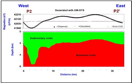
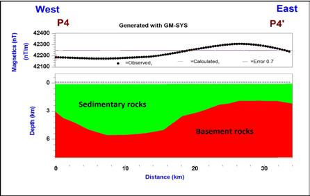
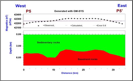
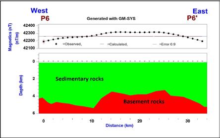
5 505


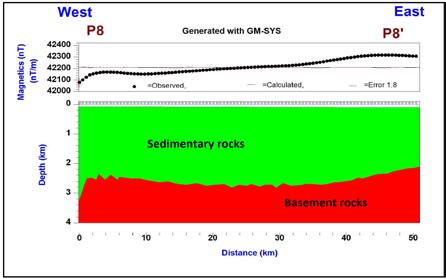
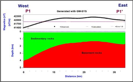
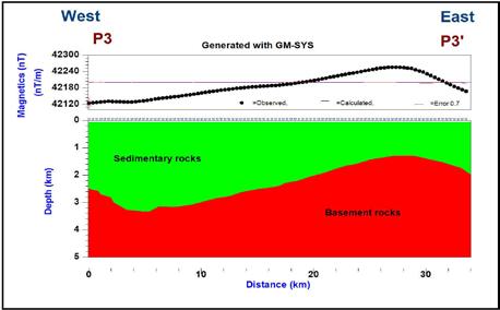
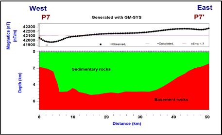
6 Fig.6: 2D Magnetic modeling along profiles from profile P1 P1 to profile P9 P9. 3 D Modeling 3D models are defined by a number of surface grids with a density distribution (and/or susceptibility & remanent magnetization distribution) assigned to each layer. Layer density may be specified using either a constant density, a vertical density-depth profile relative to a reference surface, or a laterally-varying density distribution defined by a grid. Layer susceptibility may be specified using either a constant susceptibility and remanent magnetization, or a laterally-varying susceptibility distribution. (a) (b) 506
 (c) 3-D magnetic modeling were used to construct the basement relief map (Fig.")


7 Fig. 7 (a,b and c) : Outputs of GMSYS-3D modeling; a observed anomalies, b calculated anomalies and c deviation between calculated and measured anomalies (error) (c) 3-D magnetic modeling were used to construct the basement relief map (Fig. 8 a,b) (b) (a) Fig. 8.(a and b) : 3D-Basement relief map. From the results of 3 D modeling the basement depth ranges from about 1484 m to about 5425 m and these results are compatible with the results of 2 D modeling. The depth of basement found in western and eastern parts of the study area is very deep which have values more than 5000 m, which is indicate for thick sedimentary cover, but it decrease gradually in southern and northern directions to reach depth have values less than 1500 m. 507

 by using low and high pass filter technique of wave number 0.0178 cycles/k-unit.")
8 Gravity data acquisitions Gravity data Sixty-three gravity stations carried out using Auto-Grav (CG3) gravity meter of sensitivity of 0.01 mgal.the measured gravity values corrected to different gravity corrections such as, drift, tide, free-air, Bouguer, latitude and topographic corrections. The corrected gravity values used to plot Bouguer anomaly map using Oasis Montaj, 2008 (Fig. 9). The Bouguer anomaly map is separated directly into regional and residual components (Fig.10 and 11) by using low and high pass filter technique of wave number cycles/k-unit. The regional- residual separation technique carried out to filter the regional component, which related to deep-seated sources and residual component, which related to local sources. Fig. 9 : Observed Bouguer anomaly map Fig.10: Regional Gravity Anomaly Map 508

9 The residual gravity anomaly map (Fig.11) represents actually the distribution of the gravity field at a shallow depth after removing the regional effect. The critical characteristics of the residual gravity anomaly map in the study area can be summarized in the following: The residual gravity anomaly field in the study area ranges between a maximum value (3.2m.gal) at NW, NE,S, E of central part of study area and a minimum value (-4.3 m.gal) at E part which have coordinates long E and between lat N and lat N and W part which have coordinates long E and between lat N and lat N and central part of study area which have coordinates between lat N and lat Nand between long E and long E and SW part of the study area. The positive gravity anomaly is mainly due to uplift of denser basement rock, while the lower gravity values indicate sedimentary basins. Delineating of structure elements Fig.11: Residual Gravity Anomaly Map. The faults locations and they directions have been detected by two ways: the first way by the residual gravity anomaly map to determine the faults which affecting in the study area and the second way by Euler Deconvolution. The residual gravity anomaly map (Fig.11) used to detect and trends of the faults dissecting the study area. The location of faults can be detected between high and low gravity anomalies and the downthrown of faults towards low anomalies. This map (Fig.12) dissected by about 24 faults. These faults take different directions N-S, E-W, NE-SW, and NW-SE trend. Euler deconvolution or Euler depth deconvolution is a tool for potential field interpretation. This method used to determines the depth of source of anomaly and structural index of a list of anomalies. The Euler deconvolution process is applied at each solution. The best solutions which make the data are concentrated at some places in the study area not distributed all over the area. In the present study the structural index which applied, structural index 0, 0.5 and 1 to select the best solution, The structural index 0 (Fig.13) gives better solutions than structural index 0.5(Fig. 14) and 1 (Fig. 15), because the solutions are concentrated at some places in the study area not distributed all 509
 : a)fault Elements Dissecting the Study Area, b)rose Diagram for the Major Trend Faults detecting from residual anomaly map. Fig.")
10 over the area as SI=0.5 and SI=1. Finally, the two ways, from the residual gravity anomaly map and Euler Deconvolution give similar results. (b) (a) Fig.12 (a and b) : a)fault Elements Dissecting the Study Area, b)rose Diagram for the Major Trend Faults detecting from residual anomaly map. Fig.13: Euler Solutions of Structural Index =
 (Fig.")

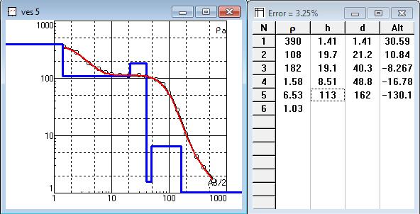
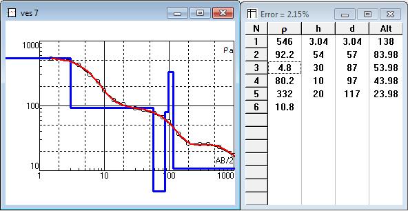
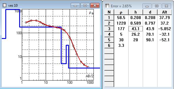
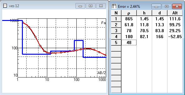
11 Fig.14: Euler Solutions of Structural Index=0. Fig.15: Euler Solutions of Structural Index = 1 Geoelectric method Geoelectrical data acquisition and interpretation. The resistivity method is used for detecting ground water presence and differentiating subsurface layers. The data of resistivity were Twenty Vertical Electrical Sounding (VES) (Fig.16), Two VES stations have been done beside two boreholes for correlation between resistivity data and boreholes data. The first borehole is Al Awsat Well and the second borehole is Al Shohat Well. Then the interpretation applied using the IPI2WIN program. The quantitative interpretation has been applied to determine the thicknesses and true resistivity of the stratigraphic units beside each VES station (Fig. 17,18 and 19). The results of the interpretation of the resistivity data for the two VES station, which measured beside the two boreholes, indicate good similarity for the results of the borehole data. As shown in (Fig.16) the results of VES interpretation are used to construct five geoelectric sections A, B, C, D and E. 511


12 Fig. 16: Location of Resistivity Soundings and Direction of the Constructed Profiles. Fig. 17: Interpretation of VES stations no. 1, 2, 3 and 4 (Using IPI2win software). 512
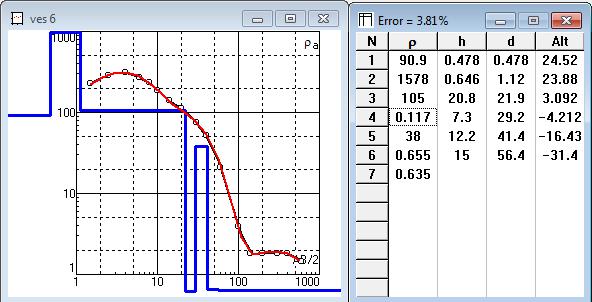
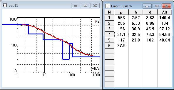

13 Fig. 18: Interpretation of VES stations no.5, 6, 7, 8, 9, 10, 11, 12, 13 and 14 (Using IPI2win software). 513


14 Fig. 19: Interpretation of VES stations no. 13, 14, 15, 16, 17, 18, 19 and 20 (Using IPI2win software). The geoelectric cross-sections exhibit five geoelectric units (Figs.20 and 21), the first unit is the quaternary sand sheet and sand dunes of high resistivity values, the second unit is the quaternary aquifer and reveals moderately to high resistivity and reflects the presence of fresh water-bearing zone,the lithology of this layer consists of sandstone, the third geoelectrical units composed of clay which reveals low resistivity values, the fourth geoelectrical unit consists of clayey sand and exhibits moderately resistivity values, this layer represent the second aquifer, the fifth geoelectrical unit is the end unit in the sections, reveals very low resistivity values and consists of clay, the faults named in accordance with the residual gravity anomaly map (Fig 20, 21 and 22). 514


15 Fig. 20: Geoelectric Cross-Section along Profiles A-A. Fig. 21: Geoelectric Cross-Section along Profiles B-B. 515


16 ` Fig. 22: Geoelectric Cross-Section along Profiles C-C, D-D,E-E and Correlation between EL Awsat Well (Drilled by Dasco.Co 2008) and cross-section of VES

 Iso-pach maps for the second and fourth geoelectric units The thickness of the second geoelectric unit in the study area is varied from 5 to 75 m, the maximum thickness is recorded at VES-16")
17 The Interpreted subsurface maps True resistivity contour maps of the two aquifers The second unit is the Quaternary aquifer and considered as the water-bearing unit in addition to the fourth unit. This unit has resistivity values ranging from m, the true resistivity values of the forth unit increase mainly to the southeastern part and around VES-5, and decrease towards northwestern, northeastern and southwestern parts of the study area (Fig.23) Iso-pach maps for the second and fourth geoelectric units The thickness of the second geoelectric unit in the study area is varied from 5 to 75 m, the maximum thickness is recorded at VES-16 towards the northeastern part of the study area the thickness increase mainly to the northeast and south parts of the study and decrease mainly to the west, the minimum thickness recorded at Ves-3. The thickness of the fourth geoelectric unit in the study area is varied from 8 to 138 m, the maximum thickness is recorded at VES-12, VES-13 and VES-18, we can say the thickness gradually increase from west to east except around VES-20 (Fig. 24) Depth contour maps to the second and fourth geoelectric units The depth of the second geoelectric unit in the study area is varied from 0.51 to 4.7 m, the maximum depth is recorded at VES-9 at the central part of the study area the thickness increase mainly to the central part of the study area also to northeastern part and southeastern part and decrease mainly towards the west and east, the minimum depth recorded at VES-4.The depth of the fourth geoelectric unit in the study area is varied from 12 to 68 m,the maximum depth is recorded at VES-17 and VES-20 at the northeastern part of the study and the minimum depth recorded at VES-3 (Fig.25) Fig. 23: Second and Fourth Geoelectric Units True Resistivity Maps 517


18 Fig. 24: Iso-pach Maps for the Second and Fourth Geoelectric Units Fig. 25: Depth Contour Maps for the Second and fourth Geoelectric Units Joint inversion interpretation for gravity and resistivity data. Gravity and resistivity data were used in the present study for groundwater exploration using a joint inversion process to determine the thickness and resistivity distribution of the different geological units in the study area. The results obtained from the inversions of synthetic data indicate that the joint inversion significantly improves the solution decreasing the ambiguity of the models. The results of the joint inverse interpretation revealed the presence of four layers are similar to the results that obtained from resistivity method, Joint inversion was applied along two profiles B-B (Fig.26) and E-E (Fig.27). 518
19 a b c Fig. 26 (a,b and c): Results of joint inversion of gravity and resistivity data along profile B-B where a) the fit of VES curves in logarithmic scale, b) the fit of the gravity curve and c) the subsurface model shown with true resistivity values in Ωm and density of 2000, 2100 and 2300 kg/m3 for gravel, sand and clayey sand, respectively. 519
20 a b c Fig. 27: Results of joint inversion of gravity and resistivity data along profile E-E where a) the fit of VES curves in logarithmic scale, b) the fit of the gravity curve and c) the subsurface model shown with true resistivity values in Ωm and density of 2000, 2100 and 2300 kg/m3 for gravel, sand and clayey sand, respectively. 520
21 CONCLUSION In finally, from all these geophysical data we can concluded that :- The depth of basement rocks ranging from 1484 to 5425 m. The major faults trend which controlling in the study area take direction NE-SW. There are two aquifers, the first aquifer at the second geoelectrical units with thickness range from (4.5 m to 75 m), the lithology of this layer consists of sandstone. The second aquifer at the fourth units with thickness range from (9 m to 137 m) and consists of clayey sand. There are two aquifers zones, the first zone along the Mediterranean Sea and Suez Canal, salinity more than ppm and the depth to water is about 2 m from the ground surface depends on the topographic surface, this zone is used for fish cultivation. The second zone is relatively far from Mediterranean Sea and Suez Canal, the thickness varying from 20 to 100 m, well depths from 8 to 120m, depth to water from 3 to 55 m from the ground surface, and the salinity ranging from 500 to 4000 ppm, many seasonal and permanent agricultural crops occurred in this zone. REFERENCES Al Abassy, K., A., A., (2010): Geophysical and Hydrogeological Studies East of Suez Canal, Egypt, MSc., Al-Azhar Uni., Cairo, Egypt, 183P. in the Area ENVI-MAG Manual, November, (1994): SCINTREX, Produced by GEO F/X Printed and Bound in Canada, 265 P. Elkhedr H. Ibrahim, Mohamed R. Shereef, Ahmed A. El Galladi and Laust B. Pederson; 2004 : Geoelectric study on Quaternay groundwater aquifer in northwestern Sinai, Egypt, EGS Journal, vol. 2, No. 1, IPI2WIN Program; Version 3.1 2C; ( ): Copyright@ , Bobachev A. A., Programs set for VES data interpretation. Dep. Of geophysics, geological faculty, Moscow State University, Russia, Murty, B.V.S. and Raghavan, V.K., The gravity method in groundwater exploration in crystalline rocks: a study in the peninsular granitic region of Hyderabad, India. Hydrogeology Journal, 10, DOI /s Oasis Montaj Programs, (2008): Geosoft mapping and processing system: version (HJ), Inc Suit 500, Richmound St. West Toronto, ON Canada N5SIV6. Sultan, S.A. and El Sorady, A.L., Geoelectric and gravity measurements for groundwater exploration and detection of structural elements at Romana area, Northwest of Sinai, Egypt., in Proceedings of the 6th Conf. Geology of Sinai for Development, Ismailia,
22 Sultan, S.A., Hatem M. Mekhemer, F. A. M. Santos, (2009): Groundwater exploration and evaluation by using geophysical interpretation (case study: Al Qantara East, North Western Sinai, Egypt)., Arabian Journal of Geosciences, Volume 2, Issue 3, pp UNSECO Cairo Office, Geologic Map of Sinai, Egypt, Scale 1:500,000, Project for the Capacity Building of the Egyptian Geological survey and Mining Authority and the National Authority for Remote Sensing and Space Science in Cooperation with UNDP and UNSECO., Geological Survey of Egypt. 522
Geophysical Study of the Sedimentary Cover in Darb El-Arbeen, South Western Desert, Egypt
 Memoirs of the Faculty of Engineering, Kyushu University, Vol.68, No.1, March 2008 Geophysical Study of the Sedimentary Cover in Darb El-Arbeen, South Western Desert, Egypt by MOHAMED ABDEL ZAHER *, SULTAN
The impact of geologic setting on the groundwater occurrence in the Eocene limestone of El Minia-East Nile-Egypt, using geoelectrical technique
 Available online at www.pelagiaresearchlibrary.com Advances in Applied Science Research, 2016, 7(4):257-273 ISSN: 0976-8610 CODEN (USA): AASRFC The impact of geologic setting on the groundwater occurrence
Horizontal gradient and band-pass filter of aeromagnetic data image the subsurface structure; Example from Esh El Mellaha Area, Gulf of Suez, Egypt.
 Horizontal gradient and band-pass filter of aeromagnetic data image the subsurface structure; Example from Esh El Mellaha Area, Gulf of Suez, Egypt. Essam Aboud 1, Serguei Goussev 2, Hassan Hassan 2, Suparno
Ground Magnetic and Electrical Resistivity Mapping for Basement Structurs over Charnokitic Terrain in Ado-Ekiti Area, Southwestern Nigeria
 International Journal of Science and Technology Volume 3 No. 10, October, 2014 Ground Magnetic and Electrical Resistivity Mapping for Basement Structurs over Charnokitic Terrain in Ado-Ekiti Area, Southwestern
Geophysical Evaluation for Evidence of Recharging the Pleistocene Aquifer at El-Nubariya Area, West Nile Delta, Egypt
 International Journal of Geosciences, 2014, 5, 324-340 Published Online March 2014 in SciRes. http://www.scirp.org/journal/ijg http://dx.doi.org/10.4236/ijg.2014.53032 Geophysical Evaluation for Evidence
CHAPTER FOUR GEOPHYSICAL INTERPRETATION AND DISCUSSION
 CHAPTER FOUR GEOPHYSICAL INTERPRETATION AND DISCUSSION 4.1. DATA PROCESSING AND INTERPRETATION 4.1.1. Introduction Processing of potential field data entails the application of various filters to the data
Active subsurface structures at Fayoum- Cairo district, Northern Western Desert, Egypt, as deduced from magnetic data
 Active subsurface structures at Fayoum- Cairo district, Northern Western Desert, Egypt, as deduced from magnetic data Ladislav BRIMICH 1,AhmedKHALIL 2,PavelKORDÍK3, Mahmoud MEKKAWI 2, Mohamed EL-BOHOTY
Integrated Interpretation of Gravity, Magnetic & Seismic data for delineation of Basement Configuration in Sadiya Block, Upper Assam, India
 P-225 Integrated Interpretation of Gravity, Magnetic & Seismic data for delineation of Basement Summary G.K.Ghosh *, S.K.Basha, V.K. Kulshreshth Gravity and magnetic data were collected jointly by National
Contribution Of Potential Field Data In Delineating The Structural-Tectonic Set-Up Of The Eastern Qattara Depression Area, Western Desert, Egypt.
 Australian Journal of Basic and Applied Sciences, 6(3): 204-223, 2012 ISSN 1991-8178 Contribution Of Potential Field Data In Delineating The Structural-Tectonic Set-Up Of The Eastern Qattara Depression
POTASH DRAGON CHILE GEOPHYSICAL SURVEY TRANSIENT ELECTROMAGNETIC (TEM) METHOD. LLAMARA and SOLIDA PROJECTS SALAR DE LLAMARA, IQUIQUE, REGION I, CHILE
 METHOD. LLAMARA and SOLIDA PROJECTS SALAR DE LLAMARA, IQUIQUE, REGION I, CHILE") POTASH DRAGON CHILE GEOPHYSICAL SURVEY TRANSIENT ELECTROMAGNETIC (TEM) METHOD LLAMARA and SOLIDA PROJECTS SALAR DE LLAMARA, IQUIQUE, REGION I, CHILE OCTOBER 2012 CONTENT Page I INTRODUCTION 1 II FIELD
POTASH DRAGON CHILE GEOPHYSICAL SURVEY TRANSIENT ELECTROMAGNETIC (TEM) METHOD LLAMARA and SOLIDA PROJECTS SALAR DE LLAMARA, IQUIQUE, REGION I, CHILE OCTOBER 2012 CONTENT Page I INTRODUCTION 1 II FIELD
Geophysical investigation for shallow subsurface geotechnical problems for eastern part of 15P City, Cairo, Egypt.
 P May IJISET - International Journal of Innovative Science, Engineering & Technology, Vol. 3 Issue 7, July 2016 Geophysical investigation for shallow subsurface th geotechnical problems for eastern part
Groundwater Assessment in Apapa Coast-Line Area of Lagos Using Electrical Resistivity Method
 Journal of Emerging Trends in Engineering and Applied Sciences (JETEAS) 2 (4): 673-679 Scholarlink Research Institute Journals, 2011 (ISSN: 2141-7016) jeteas.scholarlinkresearch.org Groundwater Assessment
Delineation of the subsurface structures and basement surface of the Abu-Rodaym area, Southwestern Sinai, using ground magnetic data
 Earth Planets Space, 65, 749 757, 2013 Delineation of the subsurface structures and basement surface of the Abu-Rodaym area, Southwestern Sinai, using ground magnetic data Hatem Aboelkhair 1 and Mostafa
The Use of Vertical Electrical Sounding (VES) for Subsurface Geophysical Investigation around Bomo Area, Kaduna State, Nigeria
 for Subsurface Geophysical Investigation around Bomo Area, Kaduna State, Nigeria") IOSR Journal of Engineering (IOSRJEN) e-issn: 2250-3021, p-issn: 2278-8719 Vol. 3, Issue 1 (Jan. 2013), V4 PP 10-15 The Use of Vertical Electrical Sounding (VES) for Subsurface Geophysical Investigation
IOSR Journal of Engineering (IOSRJEN) e-issn: 2250-3021, p-issn: 2278-8719 Vol. 3, Issue 1 (Jan. 2013), V4 PP 10-15 The Use of Vertical Electrical Sounding (VES) for Subsurface Geophysical Investigation
GRAVITY AND MAGNETIC SURVEY NECHAKO BASIN STUDY ACQUISITION AND PROCESSING PHASE
 GRAVITY AND MAGNETIC SURVEY NECHAKO BASIN STUDY ACQUISITION AND PROCESSING PHASE Report prepared for the B.C. Ministry of Energy and Mines Resource Development Division New Ventures Branch by Bemex Consulting
Hydrology: Current Research
 Hydrology: Current Research ISSN: 2157-7587 Hydrology Current Research Barseem et al., 2015, 6:2 DOI: 10.4172/2157-7587.1000207 Research Article Open Access Geoelectrical Exploration in South Qantara Shark
1-D Electrical Resistivity Survey For Groundwater In Ketu-Adie Owe, Ogun State, Nigeria.
 IOSR Journal of Applied Geology and Geophysics (IOSR-JAGG) e-issn: 2321 0990, p-issn: 2321 0982.Volume 3, Issue 5 Ver. I (Sep. - Oct. 2015), PP 75-82 www.iosrjournals.org 1-D Electrical Resistivity Survey
3D Geometry of the Xade Complex inferred from Gravity and Magnetic Data
 Geophysical Case Histories 3D Geometry of the Xade Complex inferred from Gravity and Magnetic Data 1. British Geological Survey, Edinburgh, United Kingdom Paper 92 Pouliquen, G. [1], Key, R. [1] ABSTRACT
Available online Journal of Scientific and Engineering Research, 2016, 3(2):1-7. Research Article
:1-7. Research Article") Available online www.jsaer.com, 2016, 3(2):1-7 Research Article ISSN: 2394-2630 CODEN(USA): JSERBR Assessment of the Reliability of Magnetic Method to Delineate Geologic Features in a Basement Complex:
Available online www.jsaer.com, 2016, 3(2):1-7 Research Article ISSN: 2394-2630 CODEN(USA): JSERBR Assessment of the Reliability of Magnetic Method to Delineate Geologic Features in a Basement Complex:
Vertical electrical sounding (VES) for subsurface geophysical investigation in Kanigiri area, Prakasam district, Andhra Pradesh, India
 for subsurface geophysical investigation in Kanigiri area, Prakasam district, Andhra Pradesh, India") Available online at www.pelagiaresearchlibrary.com Advances in Applied Science Research, 2014, 5(5):82-86 ISSN: 0976-8610 CODEN (USA): AASRFC Vertical electrical sounding (VES) for subsurface geophysical
Available online at www.pelagiaresearchlibrary.com Advances in Applied Science Research, 2014, 5(5):82-86 ISSN: 0976-8610 CODEN (USA): AASRFC Vertical electrical sounding (VES) for subsurface geophysical
GRAVITY AND MAGNETIC METHODS
 Presented at Short Course IX on Exploration for Geothermal Resources, organized by UNU-GTP, GDC and KenGen, at Lake Bogoria and Lake Naivasha, Kenya, Nov. 2-24, 2014. Kenya Electricity Generating Co.,
Evaluation of Subsurface Formation of Pabna District, Bangladesh
 IOSR Journal of Applied Geology and Geophysics (IOSR-JAGG) e-issn: 2321 0990, p-issn: 2321 0982.Volume 1, Issue 4 (Sep. Oct. 2013), PP 30-36 Evaluation of Subsurface Formation of Pabna District, Bangladesh
C5 Magnetic exploration methods data analysis techniques
 C5 Magnetic exploration methods data analysis techniques C5.1 Data processing and corrections After magnetic field data have been collected a number of corrections are applied to simplify the interpretation.
GEOELECTRICAL INVESTIGATIONS OF MARINE INTRUSIONS ON THE ROMANIAN BLACK SEA SHORE
 GEOELECTRICAL INVESTIGATIONS OF MARINE INTRUSIONS ON THE ROMANIAN BLACK SEA SHORE P. GEORGESCU, D. IOANE, B.M. NICULESCU, F. CHITEA University of Bucharest, Department of Geophysics, 6 Traian Vuia Street,
RESISTIVITY IMAGING AND BOREHOLE INVESTIGATION OF THE BANTING AREA AQUIFER, SELANGOR, MALAYSIA. A.N. Ibrahim Z.Z.T. Harith M.N.M.
 JOURNAL OF ENVIRONMENTAL HYDROLOGY The Electronic Journal of the International Association for Environmental Hydrology On the World Wide Web at http://www.hydroweb.com VOLUME 11 2003 RESISTIVITY IMAGING
MICRO LEVEL GEO-RESISTIVITY SURVEY THROUGH V.E.S. TEST FOR GROUNDWATER FEASIBILITY STUDY AND SELECTION OF BORE WELL SITES IN PIPILI BLOCK OF PURI
 Review of Environment and Earth Sciences 2014 Vol.1, No.2, pp. 37-45 ISSN(e): 2313-8440 ISSN(p): 2409-2150 DOI: 10.18488/journal.80/2014.1.2/80.2.37.45 MICRO LEVEL GEO-RESISTIVITY SURVEY THROUGH V.E.S.
AN INTEGRATED GEOPHYSICAL INVESTIGATION OF A SPRING IN IBUJI, IGBARA-OKE, SOUTHWESTERN NIGERIA.
 Ife Journal of Science vol. 13, no. 1 (2011) AN INTEGRATED GEOPHYSICAL INVESTIGATION OF A SPRING IN IBUJI, IGBARA-OKE, SOUTHWESTERN NIGERIA. 63 Bayode S. * and Akpoarebe O. Department of Applied Geophysics,
Geoelectric Evaluation of Groundwater Potential: A Case Study of Sabongida-Ora and Environs, Southern Nigeria
 JASEM ISSN 9-8 All rights reserved Full-text Available Online at www.ajol.info and www.bioline.org.br/ja J. Appl. Sci. Environ. Manage. Dec, 0 Vol. () 9 - Geoelectric Evaluation of Groundwater Potential:
DELINEATION OF FRESH-BRACKISH WATER AND BRACKISH-SALINE WATER INTERFACES USING VES SOUNDINGS IN SHANI, BORNO STATE, NIGERIA
 JOURNAL OF ENVIRONMENTAL HYDROLOGY The Electronic Journal of the International Association for Environmental Hydrology On the World Wide Web at http://www.hydroweb.com VOLUME 19 2011 DELINEATION OF FRESH-BRACKISH
Scholars Research Library. Geophysical investigation of effects of topographic complexities on groundwater potential in Ibusa, Delta State Nigeria
 Available online at www.scholarsresearchlibrary.com Scholars Research Library Archives of Physics Research, 010, 1 (3):6-71 (http://scholarsresearchlibrary.com/archive.html) ISSN 0976-0970 CODEN (USA):
2) First Order Resistivity Effects. The first order effects discussed above in the main reflect vertical resistivity features. (1) Surficial Zone (R3)
 First Order Resistivity Effects. The first order effects discussed above in the main reflect vertical resistivity features. (1) Surficial Zone (R3)") The first and second order effects represent clear and obvious features in the data, while the third order effects are subtle, appearing real and consistent, but on the limit of interpretability. A number
The first and second order effects represent clear and obvious features in the data, while the third order effects are subtle, appearing real and consistent, but on the limit of interpretability. A number
Application of Remote Sensing and Geo-Electrical Method for Groundwater Exploration in Khor Al Alabyad, North Kordofan State, Sudan
 American Journal of Earth Sciences 2015; 2(6): 242-246 Published online January 10, 2016 (http://www.openscienceonline.com/journal/ajes) ISSN: 2381-4624 (Print); ISSN: 2381-4632 (Online) Application of
Vertical Electrical Sounding Survey for Groundwater Exploration in Parts of Anyigba and its Environs, in the Anambra Basin of Nigeria
 British Journal of Applied Science & Technology 4(): 978-988, 204 SCIENCEDOMAIN international www.sciencedomain.org Vertical Electrical Sounding Survey for Groundwater Exploration in Parts of and its Environs,
Geophysical Investigation of Ground Water Using Vertical Electrical Sounding and Seismic Refraction Methods
 International Journal of Petroleum and Petrochemical Engineering (IJPPE) Volume 2, Issue 1, 2016, PP 6-11 ISSN 2454-7980 (Online) www.arcjournals.org Geophysical Investigation of Ground Water Using Vertical
Gravity-Magnetic & Magneto-Telluric surveys in Purnea Onland Basin, India - A case history.
 P-281 Gravity-Magnetic & Magneto-Telluric surveys in Purnea Onland Basin, India - A case history. Summary A.K. Roy, D.P. Paine*, S. Sett, and H.N. Bhattacharya, ONGC This paper describes a case history
Geoelectric Resistivity Survey for Site Investigation in East Matruh Area, North Western Desert, Egypt
 World Applied Sciences Journal 21 (7): 1008-1016, 2013 ISSN 1818-4952 IDOSI Publications, 2013 DOI: 10.5829/idosi.wasj.2013.21.7.2871 Geoelectric Resistivity Survey for Site Investigation in East Matruh
Scholars Research Library
 Available online at www.scholarsresearchlibrary.com Scholars Research Library Archives of Physics Research, 2010, 1 (2):37-45 (http://scholarsresearchlibrary.com/archive.html) ISSN 0976-0970 2-D Resistivity
S.I. Fadele, M.Sc. 1 ; P.O. Sule, Ph.D. 1 ; and B.B.M. Dewu, Ph.D * ABSTRACT
 The Use of Vertical Electrical Sounding (VES) for Groundwater Exploration around Nigerian College of Aviation Technology (NCAT), Zaria, Kaduna State, Nigeria. S.I. Fadele, M.Sc. 1 ; P.O. Sule, Ph.D. 1
Gravity Support for Hydrocarbon Exploration at the Prospect Level
 Journal of Emerging Trends in Engineering and Applied Sciences (JETEAS) 2 (1): 1-6 Scholarlink Research Institute Journals, 2011 (ISSN: 2141-7016) jeteas.scholarlinkresearch.org Journal of Emerging Trends
 http://foundation.aapg.org/students/undergraduate/weeks.cfm Tim Carr - West Virginia University 3 Potential Fields Indirect Visualization Density and Magnetization Gravity and Magnetic Exploration Locate
Subsurface Characterization using Electrical Resistivity(Dipole-Dipole) method at Lagos State University (LASU) Foundation School, Badagry
 method at Lagos State University (LASU) Foundation School, Badagry") Available online at www.pelagiaresearchlibrary.com Advances in Applied Science Research, 2010, 1 (1): 174-181 Subsurface Characterization using Electrical Resistivity(Dipole-Dipole) method at Lagos State
Available online at www.pelagiaresearchlibrary.com Advances in Applied Science Research, 2010, 1 (1): 174-181 Subsurface Characterization using Electrical Resistivity(Dipole-Dipole) method at Lagos State
Analysis of electrical resistivity data for the determination of aquifer depth at Sapele RD in Benin city
 Available online at www.pelagiaresearchlibrary.com Advances in Applied Science Research, 203, 4(6):268-276 ISSN: 0976-860 CODEN (USA): AASRFC Analysis of electrical resistivity data for the determination
EVALUATION OF AQUIFER CHARACTERISTICS FOR SELECTED NEW METHOD OF THE UM RUWABA FORMATION: NORTH KORDOFAN STATE, SUDAN
 EVALUATION OF AQUIFER CHARACTERISTICS FOR SELECTED NEW METHOD OF THE UM RUWABA FORMATION: NORTH KORDOFAN STATE, SUDAN ELHAGA.B *1; ELZIENS.M*2 ANDLISSANN.H*3 *1Department of C i v i l E n g i n e e r i
FIG. 1 TOPOLOGY MAP SHOWING THE SURVEY AREA.
 SCIENCE WORLD JOURNAL VOL 2 (NO3) 2007 FULL LENGTH RESEARCH ARTICLE A REGIONAL GEOELECTRIC INVESTIGATION FOR GROUNDWATER EXPLORATION IN MINNA AREA, NORTH WEST NIGERIA. MOHAMMED, L. N. 1, *ABOH, H. O. 2
Groundwater Sustainability at Wadi Al Bih Dam, Ras El Khaimah, United Arab Emirates (UAE) using Geophysical methods
 using Geophysical methods") Groundwater Sustainability at Wadi Al Bih Dam, Ras El Khaimah, United Arab Emirates (UAE) using Geophysical methods Ahmed Murad, Amir Gabr, Saber Mahmoud, Hasan Arman & Abdulla Al Dhuhoori Geology Department
Groundwater Sustainability at Wadi Al Bih Dam, Ras El Khaimah, United Arab Emirates (UAE) using Geophysical methods Ahmed Murad, Amir Gabr, Saber Mahmoud, Hasan Arman & Abdulla Al Dhuhoori Geology Department
APPLICATION OF ELECTRICAL RESISTIVITY TOMOGRAPHY FOR SAND UNDERWATER EXTRACTION
 International Scientific Conference GEOBALCANICA 2018 APPLICATION OF ELECTRICAL RESISTIVITY TOMOGRAPHY FOR SAND UNDERWATER EXTRACTION Maya Grigorova Ivaylo Koprev University of Mining and Geology St. Ivan
Elijah Adebowale Ayolabi, Ph.D. 1, Adetayo Femi Folorunso, M.Sc. 2*, Ayodele Franklin Eleyinmi, B.Sc. 1, and Esther O. Anuyah, B.Sc.
 Applications of 1D and 2D Electrical Resistivity Methods to Map Aquifers in a Complex Geologic Terrain of Foursquare Camp, Ajebo, Southwestern Nigeria. Elijah Adebowale Ayolabi, Ph.D. 1, Adetayo Femi Folorunso,
Groundwater Level Monitoring of the Quaternary Aquifer at Al Ain City, United Arab Emirates (UAE) using Geophysical Methods
 using Geophysical Methods") Groundwater Level Monitoring of the Quaternary Aquifer at Al Ain City, United Arab Emirates (UAE) using Geophysical Methods Ahmed Murad & Amir Gabr Geology Department UAE University Outlines Introduction
Groundwater Level Monitoring of the Quaternary Aquifer at Al Ain City, United Arab Emirates (UAE) using Geophysical Methods Ahmed Murad & Amir Gabr Geology Department UAE University Outlines Introduction
Imaging VTEM Data: Mapping Contamination Plumes In Tarlton, South Africa
 Imaging VTEM Data: Mapping Contamination Plumes In Tarlton, South Africa M. Combrinck Geotech Airborne Limited Summary VTEM data were acquired during a test survey flown over the Tarlton region in South
CHAPTER 9 SUMMARY AND CONCLUSIONS
 CHAPTER 9 SUMMARY AND CONCLUSIONS The following are the important conclusions and salient features of the present study. 1. The evaluation of groundwater potential is a prerequisite for any kind of planning
Nature and Science 2010;8(8)
") Subsurface Characterization and its Environmental Implications using the Electrical Resistivity Survey: Case with LASU Foundation Programme Campus Badagry, Lagos State, Nigeria 1 R. B. Adegbola 1 S. O.
Subsurface Characterization and its Environmental Implications using the Electrical Resistivity Survey: Case with LASU Foundation Programme Campus Badagry, Lagos State, Nigeria 1 R. B. Adegbola 1 S. O.
QUALITATIVE INTERPRETATION OF POTENTIAL FIELD PROFILES: SOUTHERN NECHAKO BASIN
 QUALITATIVE INTERPRETATION OF POTENTIAL FIELD PROFILES: SOUTHERN NECHAKO BASIN By Melvyn E. Best Bemex Consulting International 5288 Cordova Bay Road Victoria, B.C. V8Y 2L4 KEYWORDS: potential fields,
Aeromagnetic Data Interpretation for Geostructural Analysis of Ibadan, Southwestern Nigeria
 Aeromagnetic Data Interpretation for Geostructural Analysis of Ibadan, Southwestern Nigeria 1 Sunmonu, L.A., 2* Olasunkanmi, N. K. and 3 Alagbe, O. A. 1 Pure and Applied Physics Department, Ladoke Akintola
EVALUATION OF SOIL AND WATER RESOURCES IN WADI WARDAN, SINAI, EGYPT, USING ELECTRICAL RESISTIVITY METHOD
 Qatar Univ. Sci. Bull. (1985), 5: 321-333 EVALUATION OF SOIL AND WATER RESOURCES IN WADI WARDAN, SINAI, EGYPT, USING ELECTRICAL RESISTIVITY METHOD By MOKHTAR ABDULAZIZ SAYED* Desert Institute, Al-Matariya
Aeromagnetic data interpretation to locate buried faults in Riyadh Region, Saudi Arabia
 Scientific Research and Essays Vol. 7(22), pp. 2022-2030, 14 June, 2012 Available online at http://www.academicjournals.org/sre DOI: 10.5897/SRE11.2243 ISSN 1992-2248 2012 Academic Journals Full Length
Relevance of 2D Electrical Imaging in Subsurface Mapping: Case Study of National Animal Production Research Institute (NAPRI), Zaria.
, Zaria.") Relevance of 2D Electrical Imaging in Subsurface Mapping: Case Study of National Animal Production Research Institute (NAPRI), Zaria. S.I. Fadele, Ph.D. (in view) 1* ; J. Adamu, M.Sc. 2 ; N.O. Patrick,
Relevance of 2D Electrical Imaging in Subsurface Mapping: Case Study of National Animal Production Research Institute (NAPRI), Zaria. S.I. Fadele, Ph.D. (in view) 1* ; J. Adamu, M.Sc. 2 ; N.O. Patrick,
Geoelectrical and IP Imaging Used for Pre-investigation at a Tunnel Project. Danielsen, Berit Ensted; Arver, Henrik; Karlsson, T; Dahlin, Torleif
 Geoelectrical and IP Imaging Used for Pre-investigation at a Tunnel Project Danielsen, Berit Ensted; Arver, Henrik; Karlsson, T; Dahlin, Torleif 2008 Link to publication Citation for published version
Electrical Resistivity Survey for Delineating Seawater Intrusion in a Coastal Aquifer
 Electrical Resistivity Survey for Delineating Seawater Intrusion in a Coastal Aquifer Sung-Ho Song*, Gyu-Sang Lee*, Jin-Sung Kim*, Baekuk Seong*, Young-gyu Kim*, Myung-Ha Woo* and Namsik Park** Abstract
A Preliminary Geophysical Reconnaissance Mapping of Emirau Ground Water Resource, Emirau Island, New Ireland Province, PNG
 A Preliminary Geophysical Reconnaissance Mapping of Emirau Ground Water Resource, Emirau Island, New Ireland Province, PNG Geological Survey Division of Mineral Resources Authority (MRA) Papua New Guinea
Causes of Borehole Failure in Complex Basement Terrains: ABUAD Case Study, Southwestern Nigeria. w w w. a j e r. o r g Page 192
 American Journal of Engineering Research (AJER) e-issn: 2320-0847 p-issn : 2320-0936 Volume-4, Issue-10, pp-192-201 www.ajer.org Research Paper Open Access Causes of Borehole Failure in Complex Basement
K. A. Murana, P. Sule, A.L. Ahmed, E.M. Abraham and E.G. Obande. 1. Introduction
 Subsurface stratigraphic mapping using geoelectric method and its impact on development in Federal College of Education (technical) Gusau, Zamfara State, Nigeria K. A. Murana, P. Sule, A.L. Ahmed, E.M.
Application of Vertical Electrical Sounding to Delineate and Evaluate the Hydrological Conditions in Baiji Tikrit Basin
 Application of Vertical Electrical Sounding to Delineate and Evaluate the Hydrological Conditions in Baiji Tikrit Basin Muhanna Mitaab Ahmed Zaidoon Taha Abdulrazzaq Sabbar Abdullah Salih Department of
G. Barrocu G. Ranieri Faculty of Engineering, University of Cagliari, Italy. In the region of Muravera, south-east coast of Sardinia, the trend of
 HYDROGEOLOGICAL AND GEOPHYSICAL INVESTIGATIONS FOR EVALUATING SALT INTRUSION PHENOMENA IN SARDINIA G. Barbieri G. Barrocu G. Ranieri Faculty of Engineering, University of Cagliari, Italy Abstract In the
Groundwater Exploration In Parts Of Mangu- Halle North-Central Nigeria.
 International Journal of Scientific and Research Publications, Volume 7, Issue 10, October 2017 440 Groundwater Exploration In Parts Of Mangu- Halle North-Central Nigeria. I. Mamuda *, P.M. Akushai **
Euler Deconvolution Technique for Gravity Survey
 Journal of Applied Sciences Research, 6(11): 1891-1897, 2010 2010, INSInet Publication Euler Deconvolution Technique for Gravity Survey 12,3 Piyaphong Chenrai, 2 Jayson Meyers, 1,4 Punya Charusiri 1 Earthquake
Geothermal Energy Resources Exploration using Gravity and magnetics. By Mariita, N.O. KenGen
 Geothermal Energy Resources Exploration using Gravity and magnetics By Mariita, N.O. KenGen What is Geothermal Energy? Geothermal Energy = heat from the Earth Transmitted by fluids via fractures and pores
2-D RESISTIVITY IMAGING SURVEY FOR WATER-SUPPLY TUBE WELLS IN A BASEMENT COMPLEX: A CASE STUDY OF OOU CAMPUS, AGO-IWOYE SW NIGERIA
 2-D RESISTIVITY IMAGING SURVEY FOR WATER-SUPPLY TUBE WELLS IN A BASEMENT COMPLEX: A CASE STUDY OF OOU CAMPUS, AGO-IWOYE SW NIGERIA 1 AYOLABI, Elijah Adebowale. 2 FOLORUNSO, Adetayo Femi. and 3 ARIYO, Stephen
Geophysical Investigation of the Precambrian Marble Occurrence in Itobe Area, Central Nigeria
 British Journal of Applied Science & Technology 4(13): 1891-1904, 2014 SCIENCEDOMAIN international www.sciencedomain.org Geophysical Investigation of the Precambrian Marble Occurrence in Itobe Area, Central
Geophysical Investigation of Egbeta, Edo State, Nigeria, Using Electrical Resistivity Survey to Assess the Ground water Potential
 368 Geophysical Investigation of Egbeta, Edo State, Nigeria, Using Electrical Resistivity Survey to Assess the Ground water Potential 1 Aigbogun, Christopher O., 1 Adegbite, Joseph, T., 2 Olorunsola,Kuforijimi,
We are IntechOpen, the world s leading publisher of Open Access books Built by scientists, for scientists. International authors and editors
 We are IntechOpen, the world s leading publisher of Open Access books Built by scientists, for scientists 3,800 116,000 120M Open access books available International authors and editors Downloads Our
GEOELECTRICAL INVESTIGATION OF GROUNDWATER CONDITION IN OLEH, NIGERIA
 www.arpapress.com/volumes/vol15issue1/ijrras_15_1_14.pdf GEOELECTRICAL INVESTIGATION OF GROUNDWATER CONDITION IN OLEH, NIGERIA O. Anomohanran Physics Department, Delta State University, Abraka, Delta State,
DETECTION OF GROUNDWATER POLLUTION USING RESISTIVITY IMAGING AT SERI PETALING LANDFILL, MALAYSIA
 JOURNAL OF ENVIRONMENTAL HYDROLOGY The Electronic Journal of the International Association for Environmental Hydrology On the World Wide Web at http://www.hydroweb.com VOLUME 8 2000 DETECTION OF GROUNDWATER
Hydro-Geophysical Investigation of the Federal Housing Estate Akure, Southwestern Nigeria
 Journal of Emerging Trends in Engineering and Applied Sciences (JETEAS) 4(6): 793-799 Scholarlink Research Institute Journals, 2013 (ISSN: 2141-7016) jeteas.scholarlinkresearch.org Journal of Emerging
Mapping Magnetic Lineaments in the Foothills of Northeastern British Columbia using 2-D Wavelet Transform
 Mapping Magnetic Lineaments in the Foothills of Northeastern British Columbia using 2-D Wavelet Transform Hassan Hassan* GEDCO, Calgary, Alberta, Canada hassan@gedco.com Abstract Summary This work describes
Process, Zeit Bay Fields - Gulf of Suez, Egypt*
 PS Pressure Regime Evaluation, Role, and Contribution in Well Planning and Formation Evaluation Process, Zeit Bay Fields - Gulf of Suez, Egypt* Saber Moustafa Selim 1, Khaled Mohamed Abdallah 1, and Khalaf
3D Electrical Resistivity Tomography (ERT) Survey of a Typical Basement Complex Terrain
 Survey of a Typical Basement Complex Terrain") Journal of Emerging Trends in Engineering and Applied Sciences (JETEAS) 2 (4): 680-686 Scholarlink Research Institute Journals, 2011 (ISSN: 2141-7016) jeteas.scholarlinkresearch.org Journal of Emerging
Journal of Emerging Trends in Engineering and Applied Sciences (JETEAS) 2 (4): 680-686 Scholarlink Research Institute Journals, 2011 (ISSN: 2141-7016) jeteas.scholarlinkresearch.org Journal of Emerging
Geophysical Investigation of Foundation Condition of A Site in Ikere- Ekiti, Ekiti State, South-Western Nigeria
 Australian Journal of Basic and Applied Sciences, 5(9): 1852-1857, 2011 ISSN 1991-8178 Geophysical Investigation of Foundation Condition of A Site in Ikere- Ekiti, Ekiti State, South-Western Nigeria 1
Interpretation of Subsurface Geological Structure of Massepe Geothermal Area Using Resistivity Data
 Proceedings World Geothermal Congress 2010 Bali, Indonesia, 25-29 April 2010 Interpretation of Subsurface Geological Structure of Massepe Geothermal Area Using Resistivity Data Ahmad Zarkasyi and Yuanno
ELECTRICAL RESISTIVITY DATA INTERPRETATION FOR GROUNDWATER DETECTION IN TITTAGUDI TALUK OF CUDDALORE DISTRICT, TAMIL NADU, INDIA
 ELECTRICAL RESISTIVITY DATA INTERPRETATION FOR GROUNDWATER DETECTION IN TITTAGUDI TALUK OF CUDDALORE DISTRICT, TAMIL NADU, INDIA Uwamungu Placide 1, G.R. Senthil Kumar 2 1 M.Phil Research Scholar, Department
Case Study: University of Connecticut (UConn) Landfill
 Landfill") Case Study: University of Connecticut (UConn) Landfill Problem Statement:» Locate disposal trenches» Identify geologic features and distinguish them from leachate and locate preferential pathways in fractured
Case Study: University of Connecticut (UConn) Landfill Problem Statement:» Locate disposal trenches» Identify geologic features and distinguish them from leachate and locate preferential pathways in fractured
INTERPRETED FAULTING PATTERNS IN NORTHEAST ALBERTA USING HIGH RESOLUTION AEROMAGNETIC DATA. Canadian Journal of Exploration Geophysicists, 1998
 INTERPRETED FAULTING PATTERNS IN NORTHEAST ALBERTA USING HIGH RESOLUTION AEROMAGNETIC DATA M. E. Best 1, H. J. Abercrombie 2 and J. W. Peirce 3 Canadian Journal of Exploration Geophysicists, 1998 ABSTRACT
Potential Field investigation of Williston Basin Basement
 Potential Field investigation of Williston Basin Basement Jiakang Li* and Igor Morozov, University of Saskatchewan, Canada Summary Major faults and domains are identified in the Precambrian basement of
Groundwater Exploration using Integration of Electrical Resistivity Data with Remote Sensing and GIS Data, Northern State Sudan
 736 Groundwater Exploration using Integration of Electrical Resistivity Data with Remote Sensing and GIS Data, Northern State Sudan Dafalla Siddig Dafalla Department of Geology Email: wadiadam@gmail.com
IJISET - International Journal of Innovative Science, Engineering & Technology, Vol. 2 Issue 9, September 2015.
 Prediction of petrophysical parameters applying multi attribute analysis and probabilistic neural network techniques of seismic data for Komombo Basin, Upper Egypt. Othman, A. A. A. 1, Ewida, H. F. 2,
Exploring The Groundwater Possibilities In Wadi West Komombo-The Desert Fringes Of Aswan Governorate
 IOSR Journal of Applied Geology and Geophysics (IOSR-JAGG) e-issn: 2321 0990, p-issn: 2321 0982.Volume 6, Issue 3 Ver. III (May. June. 2018), PP 33-44 www.iosrjournals.org Exploring The Groundwater Possibilities
ASSESSMENT OF GROUNDWATER POTENTIAL IN ARUJO- RODI KOPANY AREA, HOMA BAY COUNTY, KENYA. NAME: AYETE DAVID OMAJILONG
 ASSESSMENT OF GROUNDWATER POTENTIAL IN ARUJO- RODI KOPANY AREA, HOMA BAY COUNTY, KENYA. NAME: AYETE DAVID OMAJILONG SUMMARY. Groundwater development for portable water supply in Kenya for rural people
GEOPHYSICS GRAVITY DATA COVERAGE
 GEOPHYSICS DATA COVERAGE The Mudgee-Gulgong district lies within the Dubbo 1:250,000 sheet area. This area is now covered by high res_olution gravity, magnetic and radiometric data. The aeromagnetic and
1D and 2D Inversion of the Magnetotelluric Data for Brine Bearing Structures Investigation
 1D and 2D Inversion of the Magnetotelluric Data for Brine Bearing Structures Investigation Behrooz Oskooi *, Isa Mansoori Kermanshahi * * Institute of Geophysics, University of Tehran, Tehran, Iran. boskooi@ut.ac.ir,
Land subsidence due to groundwater withdrawal in Hanoi, Vietnam
 Land Subsidence (Proceedings of the Fifth International Symposium on Land Subsidence, The Hague, October 1995). 1AHS Publ. no. 234, 1995. 55 Land subsidence due to groundwater withdrawal in Hanoi, Vietnam
ELECTRICAL RESISTIVITY IMAGING FOR QUATERNARY AQUIFER IN WADI MURAYKHAT AND WADI SA A, AL AIN AREA, UAE.
 ELECTRICAL RESISTIVITY IMAGING FOR QUATERNARY AQUIFER IN WADI MURAYKHAT AND WADI SA A, AL AIN AREA, UAE. By: Ahmed. El-Mahmoudi KFU University, Water Studies Centre, KSA Figure (#) Map of Al Jaww Plain
Impact of the Danube River on the groundwater dynamics in the Kozloduy Lowland
 GEOLOGICA BALCANICA, 46 (2), Sofia, Nov. 2017, pp. 33 39. Impact of the Danube River on the groundwater dynamics in the Kozloduy Lowland Peter Gerginov Geological Institute, Bulgarian Academy of Sciences,
Prof. Giuseppe Mandrone Prof. Cesare Comina dott. Luca Guglielmetti Dept. Earth Science, Univ. Torino (ITA)
") Prof. Giuseppe Mandrone Prof. Cesare Comina dott. Luca Guglielmetti Dept. Earth Science, Univ. Torino (ITA) Multidisciplinary approach of geothermal prospection at Terme di Vinadio/Valdieri (Cuneo - Italy):
Prof. Giuseppe Mandrone Prof. Cesare Comina dott. Luca Guglielmetti Dept. Earth Science, Univ. Torino (ITA) Multidisciplinary approach of geothermal prospection at Terme di Vinadio/Valdieri (Cuneo - Italy):
Assessment of Ground Water in a Part of Coastal West Bengal using Geo-Electrical Method
 Vol. 13, No. 2, pp. 203-210 (2013) Journal of Agricultural Physics ISSN 0973-032X http://www.agrophysics.in Research Article Assessment of Ground Water in a Part of Coastal West Bengal using Geo-Electrical
Development of geophysical investigation for verifying treatment efficiency of underground cavities
 Development of geophysical investigation for verifying treatment efficiency of underground cavities Hasan A. Kamal* Kuwait Institute for Scientific Research, Infrastructure Risk and Reliability Program,
Groundwater flow dynamic investigation without drilling boreholes
 Appl Water Sci (2017) 7:481 488 DOI 10.1007/s1320101502671 ORIGINAL ARTICLE Groundwater flow dynamic investigation without drilling boreholes Mahmoud Moustafa Received: 16 March 2014 / Accepted: 5 February
Identification of aquifer zones by VES method: A case study from Mangalore block, Tamil Nadu, S. India
 Available online at www.scholarsresearchlibrary.com Scholars Research Library Archives of Applied Science Research, 011, 3 ():414-41 (http://scholarsresearchlibrary.com/archive.html) ISSN 0975-508X CODEN
Seismic Reflection Imaging across the Johnson Ranch, Valley County, Idaho
 Seismic Reflection Imaging across the Johnson Ranch, Valley County, Idaho Report Prepared for the Skyline Corporation Lee M. Liberty Center for Geophysical Investigation of the Shallow Subsurface (CGISS)
Re-processing of 2D seismic data from Razzak oil field, Western Desert, Egypt
 American Journal of Science and Technology 2015; 2(1): 1-8 Published online November 30, 2014 (http://www.aascit.org/journal/ajst) ISSN: 2375-3846 Re-processing of 2D seismic data from Razzak oil field,
INTEGRATED GEOPHYSICAL INVESTIGATION OF SEQUENCE OF DEPOSITION OF SEDIMENTARY STRATA IN ABAKALIKI, NIGERIA ABSTRACT
 INTEGRATED GEOPHYSICAL INVESTIGATION OF SEQUENCE OF DEPOSITION OF SEDIMENTARY STRATA IN ABAKALIKI, NIGERIA Agha S.O Dept. of Industrial Physics Ebonyi State University, Abakaliki, Nigeria & Arua A.I Dept.
MAGNETIC SURVEYING AS AN AID TO GEOLOGICAL MAPPING: A CASE STUDY FROM OBAFEMI AWOLOWO UNIVERSITY CAMPUS IN ILE-IFE, SOUTHWEST NIGERIA
 Ife Journal of Science vol. 18, no. (016) MAGNETIC SURVEYING AS AN AID TO GEOLOGICAL MAPPING: A CASE STUDY FROM OBAFEMI AWOLOWO UNIVERSITY CAMPUS IN ILE-IFE, SOUTHWEST NIGERIA 331 * Oyeniyi, T. O., Salami,