ASSESSMENT OF GROUNDWATER POTENTIAL IN ARUJO- RODI KOPANY AREA, HOMA BAY COUNTY, KENYA. NAME: AYETE DAVID OMAJILONG
|
|
|
- Mervin Jenkins
- 5 years ago
- Views:
Transcription
1 ASSESSMENT OF GROUNDWATER POTENTIAL IN ARUJO- RODI KOPANY AREA, HOMA BAY COUNTY, KENYA. NAME: AYETE DAVID OMAJILONG
2 SUMMARY. Groundwater development for portable water supply in Kenya for rural people has increased greatly in the past few years. The study area has scarce surface water sources with the exploitation of groundwater being the only source for portable water. The study area has a poor historical borehole success rate with 70 percent of the boreholes drilled being unsuccessful. The existence of a few high yielding boreholes suggest that there are hydrogeological features suitable for groundwater development. The study area is underlain mainly by the tertiary volcanics, whose aquifers are controlled by the geological structures,i.e faults. Weathered/fractured zones too contribute significantly to the presence of aquifers. The analysis of drilled borehole data and resistivity measurements and geological structures will be used assess groundwater potential of the area.
3 1.0 INTRODUCTION. The water sources in the study area is limited to seasonal streams, and ponds. The largest fresh water body, Lake Victoria is located about 5 to 12 kilometers from the study area respectively. The area of study covers an area of approximately 60 square kilometers and is located at co ordinates to East and to South and altitudes between 1300 to 1450 meters above sea level. There is an increasing demand for the use of groundwater to provide portable water for domestic purposes by the area population. The geological of the area is mainly Tertiary Kaksingri Volcanics,overlain at the surface superficial deposists.
4 INTRODUCTION CONTINUED The study therefore is intended to carry out assessment of groundwater potential in the area by analyzing drilled borehole data, carrying out appropriate resistivity measurements, study geological and structural controls that contribute to high and low groundwater potential in the study area.

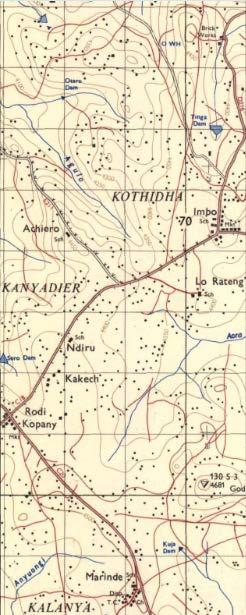
5 TOPOGRAPHICAL MAP OF THE STUDY AREA.
6 2.0 PROBLEM STATEMENT. The area has scarcity of clean portable water due to lack of reliable water sources. The current water sources are seasonal and often polluted resulting into high prevalence of water related and water borne diseases. There is therefore need to delineate high potential areas that will be suitable for drilling of high yielding boreholes and also save millions of shillings in drilling dry boreholes.
7 3.0 PROJECT RATIONALE. Map out high and poor groundwater potential areas that will be used as a basis for further groundwater exploitation in the area to provide portable water. It will also enrich the researcher the complexities of groundwater exploration and exploitation in different geological formations.
8 4.0 PROJECT GOAL To examine and understand the causes of high number of dry boreholes and provide long lasting solutions by delineating good exploitable areas/zones for borehole drilling. Improve water coverage in the study area that stands at 10 percent of the population that have access to clean water.
9 5.0 PROJECT OBJECTIVES Map out high, low and poor groundwater potential areas in the study area, where the demand for water for the rural population is expected to increase. Reduce the high number of dry boreholes and hence save funds for other activities. Determine the causes of the high percentage of unsuccessful boreholes. Suggest ways in improving groundwater exploration in such areas.
10 6.0 METHODOLOGY/SOURCE OF DATA Examine previous geological and hydrogeological investigations reports from hydro geologists, consultants and government agencies. Analyze available borehole data, that includes, drilled depths, water struck levels, water rest level, tested yields, borehole logs. Obtain some geophysical data, using electrical methods, preferably Vertical Electrical Sounding and horizontal profiling on preferred locations and sites. These will enable one to determine weathering depths of rock formations, basement, clayey formation and buried anomalies respectively that are indicators of whether a borehole can be drilled or not. Compare electrical resistivity's values of both unsuccessful and successful boreholes in similar or different geological formations. Study the geology, structures in which the unsuccessful and successful have been drilled.
11 7.0 EXPECTED OUTPUTS In its effort to provide clean portable water, the county government of Homa Bay has unveiled an ambitious programme to sink boreholes in various parts of the county including the study area. The study s output will therefore provide an insight into the groundwater potential of the study area and minimize the number of the dry boreholes. The study will also unravel factors that contribute to dry boreholes considering the adjacent areas with similar geological conditions have high success rates. The area being without other water resources, groundwater development will alleviate water scarcity and long distances to fetch water and reduce water related diseases.
12 8.0 LITERATURE REVIEW The study has been extensively covered by McCALL G.J.H Geology of the Gwassi area, Degree sheet number 41,S.W Quarter and part of N.W.Quarter.The report discusses the geology of Gwassi area which is divided into four major divisions namely the Kuja basin,the Lambwe Valley, the Gwassi hills and the Islands comprising of Mfangano and Rusinga islands respectively. The study area falls under parts of the Lambwe and kuja basin areas respectively. The report describes the geology of these areas as consisting of sediments, lavas, volcanic rocks, igneous intrusions, and corbonatites. The main structures near the study area are the kanyamwa escarpment and lambwe fault. Development of groundwater in the tertiary volcanic, sediments, Nyanzian volcanic is considered successful because of its easy weathering and decomposition
13 LITERATURE REVIEW CONTINUED The Lake Basin Domestic Water Supply and Sanitation Programme, through the DHV Consulting Engineers ,Water Resources survey report on Rangwe division, describes the geology of the study area as comprising of Nyanzian systems,kavirodian systems, granitic rocks, tertiary volcanic etc. The stratigraphy of the area is based on the following geological events that occurred in the area; Pleistocene Recent...black cotton soil Tertiary...kaksingri lavas and lateritic layers Paleozoic...no deposition Precambrian...granitic intrusions,kavirondian system(conglomerates, grits and mudstones)
14 LITERATURE REVIEW CONTINUED---- The report describes the area has having good groundwater prospects through drilling, though construction of wells will encounter hard rocks. A number of hydro geologists have carried out investigations and wrote reports of the area, among them are Anthony Ndungu, Isaiah Mawinda, and Joseph Mirobe. The reports describe the area as consisting of mainly Tertiary Kaksigri Volcanics, recent deposits, conglomerates e.t.c. The groundwater potential is concluded as being generally fair.
15 9.0EXPECTED INPUTS The following area the expected inputs, Desk studies including study of topographical and geological maps, collect borehole data and take a reconaisence to the study area and hold discussions with the leaders of the area. A tetrameter ABEM 300 will be used to conduct geophysical measurements. Other instruments include a GPS for measuring co ordinates of sites of interest. Personnel to assist in taking measurements and finances has to be availed for the study.
16 10.0 SCOPE/ LIMITATIONS. SCOPE The scope of the study area includes but not limited to the following. Collection and analyzing of borehole data including, total depths, Water Struck levels, Water rest levels and the yields. Data of electrical resistivities of successful and unsuccessful drilled boreholes will be collected and analyzed with an appropriate model. A number of electrical measurements including, Vertical Electrical Sounding, and horizontal profiling will be undertaken to probe depth of aquifers and delineate
17 LIMITATIONS With the onset of the El Niño rains, the accessibility to sites will be difficult and the water logging of the study area will not be conducive for collection of electrical resistivity data. Most of the area is also under cultivation and there is chances of hostilities by the concerned farmers to access their farms. The instrument to be used an ABEM 300 that cannot be used for 3D measurement for the sub surface conditions.
18 ITEM NO. DESCRIPTION OF ACTIVITY REQUIREMENTS 1 2 MONTHS Desk study Reports 2 Reccoinacence of the study area. Visits drilled sites GPS 3 Carry out resisistivity sounding/horizontal profiling on selected areas Resistivity equipment Personnel Transport Finance 4 Analyse resistivity data Software, laptop.stationery 5 Prepare draft report stationery 6 Final report stationery 7 Report presentation Final report
19 REFERENCES. 1). McCALL G.J.H (1958)...Geology of the Gwasi area,degree sheet 41,South- West quarterand part of North-West Quarter. 2). DHV Consulting Engineers (1985)...Water Resources survey report for Rangwe division. 3). Ndungu A.( 1999)...Hydrogeological /Geophysical investigations reports for various sites in West and East Kanyanda location,homa bay District.
First Technical Report Geophysical experiments near Kajiado town
 First Technical Report Geophysical experiments near Kajiado town Synthesis Report of First case study within the ISGEAG VIA Water project By: Michel Groen *), Harry Rolf **), and Ammon Muiti ***) *) Acacia
A Preliminary Geophysical Reconnaissance Mapping of Emirau Ground Water Resource, Emirau Island, New Ireland Province, PNG
 A Preliminary Geophysical Reconnaissance Mapping of Emirau Ground Water Resource, Emirau Island, New Ireland Province, PNG Geological Survey Division of Mineral Resources Authority (MRA) Papua New Guinea
Scholars Research Library
 Available online at www.scholarsresearchlibrary.com Scholars Research Library Archives of Physics Research, 2010, 1 (2):37-45 (http://scholarsresearchlibrary.com/archive.html) ISSN 0976-0970 2-D Resistivity
2-D RESISTIVITY IMAGING SURVEY FOR WATER-SUPPLY TUBE WELLS IN A BASEMENT COMPLEX: A CASE STUDY OF OOU CAMPUS, AGO-IWOYE SW NIGERIA
 2-D RESISTIVITY IMAGING SURVEY FOR WATER-SUPPLY TUBE WELLS IN A BASEMENT COMPLEX: A CASE STUDY OF OOU CAMPUS, AGO-IWOYE SW NIGERIA 1 AYOLABI, Elijah Adebowale. 2 FOLORUNSO, Adetayo Femi. and 3 ARIYO, Stephen
The Use of Vertical Electrical Sounding (VES) for Subsurface Geophysical Investigation around Bomo Area, Kaduna State, Nigeria
 for Subsurface Geophysical Investigation around Bomo Area, Kaduna State, Nigeria") IOSR Journal of Engineering (IOSRJEN) e-issn: 2250-3021, p-issn: 2278-8719 Vol. 3, Issue 1 (Jan. 2013), V4 PP 10-15 The Use of Vertical Electrical Sounding (VES) for Subsurface Geophysical Investigation
IOSR Journal of Engineering (IOSRJEN) e-issn: 2250-3021, p-issn: 2278-8719 Vol. 3, Issue 1 (Jan. 2013), V4 PP 10-15 The Use of Vertical Electrical Sounding (VES) for Subsurface Geophysical Investigation
GROUNDWATER OCCURRENCE IN KENYA
 GROUNDWATER OCCURRENCE IN KENYA Steven Okoth Owuor Ministry of Water and Sanitation Sunday, January 20, 2019 1 Geography INTRODUCTION The Republic of Kenya is located in East Africa The total area of the
DATA ACQUISITION METHODS FOR GROUNDWATER INVESTIGATION AND THE SITING OF WATER SUPPLY WELLS
 DATA ACQUISITION METHODS FOR GROUNDWATER INVESTIGATION AND THE SITING OF WATER SUPPLY WELLS M.B.J. Foster Tetra Tech EM Inc., San Francisco, CA, USA Keywords: Groundwater, water wells, drilled wells, geophysical
Ground-Water Exploration in the Worthington Area of Nobles County: Summary of Seismic Data and Recent Test Drilling Results
 Ground-Water Exploration in the Worthington Area of Nobles County: Summary of Seismic Data and Recent Test Drilling Results Jim Berg and Todd Petersen Geophysicists, DNR Waters January 2000 Table of Contents
GOVERNMENT OF NEPAL MINISTRY OF IRRIGATION GROUND WATER RESOURCES DEVELOPMENT BOARD BABARMAHAL, KATHMANDU, NEPAL
 GOVERNMENT OF NEPAL MINISTRY OF IRRIGATION GROUND WATER RESOURCES DEVELOPMENT BOARD BABARMAHAL, KATHMANDU, NEPAL GIS Based Updating of Groundwater Level Siraha District Final Report Submitted to Ground
Seismic Reflection Imaging across the Johnson Ranch, Valley County, Idaho
 Seismic Reflection Imaging across the Johnson Ranch, Valley County, Idaho Report Prepared for the Skyline Corporation Lee M. Liberty Center for Geophysical Investigation of the Shallow Subsurface (CGISS)
Relevance of 2D Electrical Imaging in Subsurface Mapping: Case Study of National Animal Production Research Institute (NAPRI), Zaria.
, Zaria.") Relevance of 2D Electrical Imaging in Subsurface Mapping: Case Study of National Animal Production Research Institute (NAPRI), Zaria. S.I. Fadele, Ph.D. (in view) 1* ; J. Adamu, M.Sc. 2 ; N.O. Patrick,
Relevance of 2D Electrical Imaging in Subsurface Mapping: Case Study of National Animal Production Research Institute (NAPRI), Zaria. S.I. Fadele, Ph.D. (in view) 1* ; J. Adamu, M.Sc. 2 ; N.O. Patrick,
Index Terms- Apparent Resistivity, Aquifer, Geoelectric Section, Piezometric Surface.
 Investigation of Groundwater Resources of Rafin Guza Area of Kaduna, Nigeria using Resistivity Method Olaniyan, Isaac O, Olorunnaiye, Emmanuel S. Abstract - The groundwater resources of Rafin Guza village
RESISTIVITY IMAGING AND BOREHOLE INVESTIGATION OF THE BANTING AREA AQUIFER, SELANGOR, MALAYSIA. A.N. Ibrahim Z.Z.T. Harith M.N.M.
 JOURNAL OF ENVIRONMENTAL HYDROLOGY The Electronic Journal of the International Association for Environmental Hydrology On the World Wide Web at http://www.hydroweb.com VOLUME 11 2003 RESISTIVITY IMAGING
Groundwater Exploration In Parts Of Mangu- Halle North-Central Nigeria.
 International Journal of Scientific and Research Publications, Volume 7, Issue 10, October 2017 440 Groundwater Exploration In Parts Of Mangu- Halle North-Central Nigeria. I. Mamuda *, P.M. Akushai **
Hydro-Geophysical Investigation of the Federal Housing Estate Akure, Southwestern Nigeria
 Journal of Emerging Trends in Engineering and Applied Sciences (JETEAS) 4(6): 793-799 Scholarlink Research Institute Journals, 2013 (ISSN: 2141-7016) jeteas.scholarlinkresearch.org Journal of Emerging
Utility of the 2-D Multi-Electrode Resistivity Imaging Technique in Groundwater Exploration in the Voltaian Sedimentary Basin, Northern Ghana
 Natural Resources Research, Vol. 18, No. 4, December 2009 (Ó 2009) DOI: 10.1007/s11053-009-9102-4 Utility of the 2-D Multi-Electrode Resistivity Imaging Technique in Groundwater Exploration in the Voltaian
1.0 Introduction 1.1 Geographic Location 1.2 Topography 1.3 Climate and Rainfall 1.4 Geology and Hydrogeology 1.5 Water Availability 1.
 1.0 1.1 Geographic Location 1.2 Topography 1.3 Climate and Rainfall 1.4 Geology and Hydrogeology 1.5 Water Availability 1.6 Demography 1.0 1.1 Geographic Location St. Lucia forms part of an archipelago
9-25. Sediment in Massai Steppe. Lake Natron, Lake Eyasi, Lake Manyara, Bahi swamp, part of Bubu river Purple. Purple-red Saline lake, swamp
 9.5 Productivity Analysis and Hydrogeological Map 9.5.1 Productivity Analysis Productivity distribution of groundwater was presumed by the geological condition, yield of existing wells, rainfall, topographic
Geophysical Investigation of Ground Water Using Vertical Electrical Sounding and Seismic Refraction Methods
 International Journal of Petroleum and Petrochemical Engineering (IJPPE) Volume 2, Issue 1, 2016, PP 6-11 ISSN 2454-7980 (Online) www.arcjournals.org Geophysical Investigation of Ground Water Using Vertical
Hydro-Geophysical Study of River Niger Floodplain at Jebba-North, Nigeria
 Journal of Emerging Trends in Engineering and Applied Sciences (JETEAS) 3 (1): 152-158 Scholarlink Research Institute Journals, 212 (ISSN: 2141-716) jeteas.scholarlinkresearch.org Journal of Emerging Trends
RESISTIVITY IMAGING IN EASTERN NEVADA USING THE AUDIOMAGNETOTELLURIC METHOD FOR HYDROGEOLOGIC FRAMEWORK STUDIES. Abstract.
 RESISTIVITY IMAGING IN EASTERN NEVADA USING THE AUDIOMAGNETOTELLURIC METHOD FOR HYDROGEOLOGIC FRAMEWORK STUDIES Darcy K. McPhee, U.S. Geological Survey, Menlo Park, CA Louise Pellerin, Green Engineering,
GEOELECTRICAL INVESTIGATIONS OF MARINE INTRUSIONS ON THE ROMANIAN BLACK SEA SHORE
 GEOELECTRICAL INVESTIGATIONS OF MARINE INTRUSIONS ON THE ROMANIAN BLACK SEA SHORE P. GEORGESCU, D. IOANE, B.M. NICULESCU, F. CHITEA University of Bucharest, Department of Geophysics, 6 Traian Vuia Street,
Subsurface Characterization using Electrical Resistivity(Dipole-Dipole) method at Lagos State University (LASU) Foundation School, Badagry
 method at Lagos State University (LASU) Foundation School, Badagry") Available online at www.pelagiaresearchlibrary.com Advances in Applied Science Research, 2010, 1 (1): 174-181 Subsurface Characterization using Electrical Resistivity(Dipole-Dipole) method at Lagos State
Available online at www.pelagiaresearchlibrary.com Advances in Applied Science Research, 2010, 1 (1): 174-181 Subsurface Characterization using Electrical Resistivity(Dipole-Dipole) method at Lagos State
Analysis of electrical resistivity data for the determination of aquifer depth at Sapele RD in Benin city
 Available online at www.pelagiaresearchlibrary.com Advances in Applied Science Research, 203, 4(6):268-276 ISSN: 0976-860 CODEN (USA): AASRFC Analysis of electrical resistivity data for the determination
DELINEATION OF FRESH-BRACKISH WATER AND BRACKISH-SALINE WATER INTERFACES USING VES SOUNDINGS IN SHANI, BORNO STATE, NIGERIA
 JOURNAL OF ENVIRONMENTAL HYDROLOGY The Electronic Journal of the International Association for Environmental Hydrology On the World Wide Web at http://www.hydroweb.com VOLUME 19 2011 DELINEATION OF FRESH-BRACKISH
MICRO LEVEL GEO-RESISTIVITY SURVEY THROUGH V.E.S. TEST FOR GROUNDWATER FEASIBILITY STUDY AND SELECTION OF BORE WELL SITES IN PIPILI BLOCK OF PURI
 Review of Environment and Earth Sciences 2014 Vol.1, No.2, pp. 37-45 ISSN(e): 2313-8440 ISSN(p): 2409-2150 DOI: 10.18488/journal.80/2014.1.2/80.2.37.45 MICRO LEVEL GEO-RESISTIVITY SURVEY THROUGH V.E.S.
INTRODUCTION. LOCATION OF THE STUDY AREA. DRILLING HISTORY OF THE AREA. GEOLOGY AND HYDROGEOLOGY OF THE AREA. HYDROLOGY OF THE AREA.
 INTRODUCTION. LOCATION OF THE STUDY AREA. DRILLING HISTORY OF THE AREA. GEOLOGY AND HYDROGEOLOGY OF THE AREA. HYDROLOGY OF THE AREA. RESULT ANALYSIS AND INTERPRETATION. DISCUSSION. RECOMMENDATION AND CONCLUSION.
Waterview Connection Tunnels
 Stuart Cartwright Waterview Connection Tunnels Engineering Geology Assessment of East Coast Bays Formation from Investigation through to Construction S. Cartwright, D. Koumoutsakos, B. Hill, and C. Morrison
Lima Project: Seismic Refraction and Resistivity Survey. Alten du Plessis Global Geophysical
 Lima Project: Seismic Refraction and Resistivity Survey Alten du Plessis Global Geophysical Report no 0706/2006 18 December 2006 Lima Project: Seismic Refraction and Resistivity Survey by Alten du Plessis
Vertical electrical sounding (VES) for subsurface geophysical investigation in Kanigiri area, Prakasam district, Andhra Pradesh, India
 for subsurface geophysical investigation in Kanigiri area, Prakasam district, Andhra Pradesh, India") Available online at www.pelagiaresearchlibrary.com Advances in Applied Science Research, 2014, 5(5):82-86 ISSN: 0976-8610 CODEN (USA): AASRFC Vertical electrical sounding (VES) for subsurface geophysical
Available online at www.pelagiaresearchlibrary.com Advances in Applied Science Research, 2014, 5(5):82-86 ISSN: 0976-8610 CODEN (USA): AASRFC Vertical electrical sounding (VES) for subsurface geophysical
Elijah Adebowale Ayolabi, Ph.D. 1, Adetayo Femi Folorunso, M.Sc. 2*, Ayodele Franklin Eleyinmi, B.Sc. 1, and Esther O. Anuyah, B.Sc.
 Applications of 1D and 2D Electrical Resistivity Methods to Map Aquifers in a Complex Geologic Terrain of Foursquare Camp, Ajebo, Southwestern Nigeria. Elijah Adebowale Ayolabi, Ph.D. 1, Adetayo Femi Folorunso,
An Introduction to Field Explorations for Foundations
 An Introduction to Field Explorations for Foundations J. Paul Guyer, P.E., R.A. Paul Guyer is a registered mechanical engineer, civil engineer, fire protection engineer and architect with over 35 years
Delineating The Subsurface Structures Using Electrical Resistivity Sounding In Some Part Of Willeton, Perth, Western Australia
 Delineating The Subsurface Structures Using Electrical Resistivity Sounding In Some Part Of Willeton, Perth, Western Australia Okan Evans Onojasun, Emudianughe Juliet Abstract: Geophysical survey using
Mark S. Nordberg Geology and Groundwater Investigations Section North Central Region Office California Department of Water Resources
 Mark S. Nordberg Geology and Groundwater Investigations Section North Central Region Office California Department of Water Resources Ukiah Drought Workshop July 29, 2009 Groundwater 101 Groundwater is
Alamitos Barrier Improvement Project - UPDATE
 Alamitos Barrier Improvement Project - UPDATE Seal Beach Leisure World Community Meeting Clubhouse 2 August 31, 2016 Orange County Water District Meeting Objectives Overview of OCWD Overview of the Alamitos
HYDROGEOLOGIC FRAMEWORK OF LONG ISLAND'S NORTH FORK, SUFFOLK COUNTY, NEW YORK
 HYDROGEOLOGIC FRAMEWORK OF LONG ISLAND'S NORTH FORK, SUFFOLK COUNTY, NEW YORK Christopher E. Schubert 1, Richard E. Bova 2, and Paul E. Misut 1 1 U.S. Geological Survey, 2045 Route 112, Building 4, Coram,
GEO-ELECTRIC INVESTIGATION OF THE GROUNDWATER POTENTIAL DISTRIBUTION WITHIN GWALE LOCAL GOVERNMENT AREA OF KANO STATE NIGERIA
 GEO-ELECTRIC INVESTIGATION OF THE GROUNDWATER POTENTIAL DISTRIBUTION WITHIN GWALE LOCAL GOVERNMENT AREA OF KANO STATE NIGERIA Full Length Research Article A.M. Idris, 2* G. Ahmed, 3 A. L. Ahmed, 3 K. M.
Basin Analysis Applied to Modelling Buried Valleys in the Great Lakes Basin
 EARTH SCIENCES SECTOR GENERAL INFORMATION PRODUCT 35 Basin Analysis Applied to Modelling Buried Valleys in the Great Lakes Basin Sharpe, D R; Russell, H A J 2004 Originally released as: Basin Analysis
THE UNIVERSITY OF HONG KONG LIBRARIES. Hong Kong Collection. gift from Hong Kong (China). Geotechnical Engineering Office.
. Geotechnical Engineering Office.") THE UNIVERSITY OF HONG KONG LIBRARIES Hong Kong Collection gift from Hong Kong (China). Geotechnical Engineering Office. Geotechnical Engineering Office, Civil Engineering Department The Government of
THE UNIVERSITY OF HONG KONG LIBRARIES Hong Kong Collection gift from Hong Kong (China). Geotechnical Engineering Office. Geotechnical Engineering Office, Civil Engineering Department The Government of
11/22/2010. Groundwater in Unconsolidated Deposits. Alluvial (fluvial) deposits. - consist of gravel, sand, silt and clay
 deposits. - consist of gravel, sand, silt and clay") Groundwater in Unconsolidated Deposits Alluvial (fluvial) deposits - consist of gravel, sand, silt and clay - laid down by physical processes in rivers and flood plains - major sources for water supplies
Groundwater in Unconsolidated Deposits Alluvial (fluvial) deposits - consist of gravel, sand, silt and clay - laid down by physical processes in rivers and flood plains - major sources for water supplies
The Preliminary Study of Meteorite Impact Crater at Bukit Bunuh, Lenggong
 2012 International Conference on Geological and Environmental Sciences IPCBEE vol.3 6(2012) (2012)IACSIT Press, Singapoore The Preliminary Study of Meteorite Impact Crater at Bukit Bunuh, Lenggong A. H.
PRELIMINARY. Select Geophysical Methods and Groundwater Modeling: Examples from USGS studies. Claudia Faunt and a cast of others
 Select Geophysical Methods and Groundwater Modeling: Examples from USGS studies Claudia Faunt and a cast of others Current Preliminary Studies Stanford Water in the West Groundwater Data Workshop Series:
Determination of Thickness of Aquifer with Vertical Electrical Sounding
 IOSR Journal of Mechanical and Civil Engineering (IOSR-JMCE) e-issn: 2278-1684,p-ISSN: 2320-334X, Volume 12, Issue 6 Ver. IV (Nov. - Dec. 2015), PP 52-56 www.iosrjournals.org Determination of Thickness
AN APPRAISAL OF CERTAIN CHARACTERISTICS OF AQUIFER IN CHIKUN LOCAL GOVERNMENT AREA OF KADUNA, NIGERIA
 AN APPRAISAL OF CERTAIN CHARACTERISTICS OF AQUIFER IN CHIKUN LOCAL GOVERNMENT AREA OF KADUNA, NIGERIA Isaac Oladejo Olaniyan 1 and Johnson Nimmo Tsuzom 2 1 Department of Physical Sciences, Ondo State University
Application of Remote Sensing and Geo-Electrical Method for Groundwater Exploration in Khor Al Alabyad, North Kordofan State, Sudan
 American Journal of Earth Sciences 2015; 2(6): 242-246 Published online January 10, 2016 (http://www.openscienceonline.com/journal/ajes) ISSN: 2381-4624 (Print); ISSN: 2381-4632 (Online) Application of
INTEGRATED GEOPHYSICAL INVESTIGATION OF SEQUENCE OF DEPOSITION OF SEDIMENTARY STRATA IN ABAKALIKI, NIGERIA ABSTRACT
 INTEGRATED GEOPHYSICAL INVESTIGATION OF SEQUENCE OF DEPOSITION OF SEDIMENTARY STRATA IN ABAKALIKI, NIGERIA Agha S.O Dept. of Industrial Physics Ebonyi State University, Abakaliki, Nigeria & Arua A.I Dept.
BUREAU OF MINERAL RESOURCES, GEOLOGY AND GEOPHYSICS
 COMMONWEALTH OF AUSTRALIA DEPARTMENT OF NATIONAL DEVELOPMENT BUREAU OF MINERAL RESOURCES, GEOLOGY AND GEOPHYSICS RECORD No. 1952/35 PRELIMINARY REPORT ON SEISMIC REFLECTION SURVEY, AVON AREA, GIPPSLAND,
Ground Magnetic and Electrical Resistivity Mapping for Basement Structurs over Charnokitic Terrain in Ado-Ekiti Area, Southwestern Nigeria
 International Journal of Science and Technology Volume 3 No. 10, October, 2014 Ground Magnetic and Electrical Resistivity Mapping for Basement Structurs over Charnokitic Terrain in Ado-Ekiti Area, Southwestern
Geotechnical Deskstudy for Proposed Windfarm NV NORDISK VINDKRAFT AB. Fjällberg. Östersund , rev Fjällberg
 NV NORDISK VINDKRAFT AB Östersund 23-06-2011, rev 06-07-2012 Geotechnical Deskstudy for Proposed Windfarm Date 23-06-2011, rev 06-07-2012 Project number 61811144691000 JONSSON EVA TAJANI KRISTINA TAJANI
KANSAS GEOLOGICAL SURVEY Open File Report LAND SUBSIDENCE KIOWA COUNTY, KANSAS. May 2, 2007
 KANSAS GEOLOGICAL SURVEY Open File Report 2007-22 LAND SUBSIDENCE KIOWA COUNTY, KANSAS Prepared by Michael T. Dealy L.G., Manager, Wichita Operations SITE LOCATION The site was approximately four miles
INTERGRATED GEOPHYSICAL METHODS USED TO SITE HIGH PRODUCER GEOTHERMAL WELLS
 Presented at Short Course VII on Exploration for Geothermal Resources, organized by UNU-GTP, GDC and KenGen, at Lake Bogoria and Lake Naivasha, Kenya, Oct. 27 Nov. 18, 2012. GEOTHERMAL TRAINING PROGRAMME
Ground Water in the Piedmont and Blue Ridge
 engineering earth's development preserving earth's integrity Engineering Earth s Development Preserving Earth s Integrity Ground Water in the Piedmont and Blue Ridge Jim Renner Acknowledgements Contributors:
GEOTHERMAL POTENTIAL OF ST. KITTS AND NEVIS ISLANDS
 GEOTHERMAL POTENTIAL OF ST. KITTS AND NEVIS ISLANDS By Gerald W. Huttrer Geothermal Management Company, Inc. For the Eastern Caribbean Geothermal Energy Project ( Geo- Caraibes ; G-C ) Presented Using
Directed Reading. Section: Types of Maps
 Skills Worksheet Directed Reading Section: Types of Maps 1. What are some of the characteristics of an area shown on maps used by Earth scientists? a. types of animals, types of plants, types of minerals
Case Study: University of Connecticut (UConn) Landfill
 Landfill") Case Study: University of Connecticut (UConn) Landfill Problem Statement:» Locate disposal trenches» Identify geologic features and distinguish them from leachate and locate preferential pathways in fractured
Case Study: University of Connecticut (UConn) Landfill Problem Statement:» Locate disposal trenches» Identify geologic features and distinguish them from leachate and locate preferential pathways in fractured
Geophysical Study of Limestone Attributes At Abudu Area of Edo State, Nigeria
 Journal of Emerging Trends in Engineering and Applied Sciences (JETEAS) 2 (5): 795-800 Scholarlink Research Institute Journals, 2011 (ISSN: 2141-7016) jeteas.scholarlinkresearch.org Journal of Emerging
Description DESCRIPTION
 DESCRIPTION The location of the Upper James Watershed is located in northeastern South Dakota as well as southeastern North Dakota. It includes the following counties located in North Dakota Barnes, Dickey,
Integrated Geophysical Interpretation On The Groundwater Aquifer (At The North Western Part of Sinai, Egypt)
") Integrated Geophysical Interpretation On The Groundwater Aquifer (At The North Western Part of Sinai, Egypt) Sultan Awad Sultan Araffa 1, Hassan S. Sabet 2, Ahmed M, Al Dabour 3 1 National Research Institute
Integrated Geophysical Interpretation On The Groundwater Aquifer (At The North Western Part of Sinai, Egypt) Sultan Awad Sultan Araffa 1, Hassan S. Sabet 2, Ahmed M, Al Dabour 3 1 National Research Institute
3.0 GEOLOGY AND HYDROGEOLOGY
 3.0 GEOLOGY AND HYDROGEOLOGY 3.1 Methodology The Geological Survey of Ireland (GSI) publication Geology of South Cork was consulted to establish the nature of the bedrock lithology and Quaternary sediments.
Harvey Thorleifson, Director, Minnesota Geological Survey. Status of geological mapping needed for groundwater protection in Minnesota
 Harvey Thorleifson, Director, Minnesota Geological Survey Status of geological mapping needed for groundwater protection in Minnesota Minnesota is located between the Dakotas and Wisconsin, north of Iowa,
Application of Vertical Electrical Sounding (VES) In Delineating Ground Water Potential in Some Part of Jalingo, Taraba State North Eastern Nigeria
 In Delineating Ground Water Potential in Some Part of Jalingo, Taraba State North Eastern Nigeria") Application of Vertical Electrical Sounding (VES) In Delineating Ground Water Potential in Some Part of Jalingo, Taraba State North Eastern Nigeria Kasidi S 1 and Lazarus G. Ndatuwong 2 1 Department of
Application of Vertical Electrical Sounding (VES) In Delineating Ground Water Potential in Some Part of Jalingo, Taraba State North Eastern Nigeria Kasidi S 1 and Lazarus G. Ndatuwong 2 1 Department of
IBI CORPORATION. GOLD and OTHER MINERAL EXPLORATION IN UGANDA
 IBI CORPORATION GOLD and OTHER MINERAL EXPLORATION IN UGANDA In the last two years, gold has taken on a renewed glitter, with a significant run-up in price. This aspect has obviously created the current
GEOPHYSICS GRAVITY DATA COVERAGE
 GEOPHYSICS DATA COVERAGE The Mudgee-Gulgong district lies within the Dubbo 1:250,000 sheet area. This area is now covered by high res_olution gravity, magnetic and radiometric data. The aeromagnetic and
TOPOGRAPHIC RELIEF MAP of NYS. LANDFORMS of NYS. Landforms. Creation of NYS Landforms 9/22/2011
 TOPOGRAPHIC RELIEF MAP of NYS LANDFORMS of NYS Prof. Anthony Grande AFG 2011 Landforms The basis of present-day landforms (surface features) is the bedrock geology that has been worked on by the forces
Euler Deconvolution JAGST Vol. 15(1) 2013
 2013") Euler Deconvolution JAGST Vol. 15(1) 2013 2D-EULER DECONVOLUTION AND FORWARD MODELING OF GRAVITY DATA OF HOMA-HILLS GEOTHERMAL PROSPECT, KENYA A. Odek 1, A. B. Otieno 1, W. J. Ambusso 1 and J. G. Githiri
Euler Deconvolution JAGST Vol. 15(1) 2013 2D-EULER DECONVOLUTION AND FORWARD MODELING OF GRAVITY DATA OF HOMA-HILLS GEOTHERMAL PROSPECT, KENYA A. Odek 1, A. B. Otieno 1, W. J. Ambusso 1 and J. G. Githiri
S.I. Fadele, M.Sc. 1 ; P.O. Sule, Ph.D. 1 ; and B.B.M. Dewu, Ph.D * ABSTRACT
 The Use of Vertical Electrical Sounding (VES) for Groundwater Exploration around Nigerian College of Aviation Technology (NCAT), Zaria, Kaduna State, Nigeria. S.I. Fadele, M.Sc. 1 ; P.O. Sule, Ph.D. 1
B. T. Brady, M. S. Bedinger, John Mikels, William H. Langer, and Deborah A. Mulvihill
 DEPARTMENT OF THE INTERIOR UNITED STATES GEOLOGICAL SURVEY TO ACCOMPANY WRI REPORT 83-4121-B MAP SHOWING GROUND-WATER LEVELS, SPRINGS. AND DEPTH TO GROUND WATER, BASIN AND RANGE PROVINCE, TEXAS by B. T.
Surface Processes Focus on Mass Wasting (Chapter 10)
") Surface Processes Focus on Mass Wasting (Chapter 10) 1. What is the distinction between weathering, mass wasting, and erosion? 2. What is the controlling force in mass wasting? What force provides resistance?
Surface Processes Focus on Mass Wasting (Chapter 10) 1. What is the distinction between weathering, mass wasting, and erosion? 2. What is the controlling force in mass wasting? What force provides resistance?
TATA CHEMICALS MAGADI LIMITED (Mining Section) TRONA CRUSHING PLANT AND PREWASH TANK FACILITY PROJECT
 TRONA CRUSHING PLANT AND PREWASH TANK FACILITY PROJECT") 1 TATA CHEMICALS MAGADI LIMITED (Mining Section) TRONA CRUSHING PLANT AND PREWASH TANK FACILITY PROJECT RFQ for Geotechnical Investigations and Foundation Recommendations TCML/MS/RFQ1/2017 October 2017
1 TATA CHEMICALS MAGADI LIMITED (Mining Section) TRONA CRUSHING PLANT AND PREWASH TANK FACILITY PROJECT RFQ for Geotechnical Investigations and Foundation Recommendations TCML/MS/RFQ1/2017 October 2017
EVALUATION OF AQUIFER CHARACTERISTICS FOR SELECTED NEW METHOD OF THE UM RUWABA FORMATION: NORTH KORDOFAN STATE, SUDAN
 EVALUATION OF AQUIFER CHARACTERISTICS FOR SELECTED NEW METHOD OF THE UM RUWABA FORMATION: NORTH KORDOFAN STATE, SUDAN ELHAGA.B *1; ELZIENS.M*2 ANDLISSANN.H*3 *1Department of C i v i l E n g i n e e r i
Electrical Resistivity Survey for Delineating Seawater Intrusion in a Coastal Aquifer
 Electrical Resistivity Survey for Delineating Seawater Intrusion in a Coastal Aquifer Sung-Ho Song*, Gyu-Sang Lee*, Jin-Sung Kim*, Baekuk Seong*, Young-gyu Kim*, Myung-Ha Woo* and Namsik Park** Abstract
EXTREMELY FAST IP USED TO DELINEATE BURIED LANDFILLS. Norman R. Carlson, Cris Mauldin Mayerle, and Kenneth L. Zonge
 EXTREMELY FAST IP USED TO DELINEATE BURIED LANDFILLS Norman R. Carlson, Cris Mauldin Mayerle, and Kenneth L. Zonge Zonge Engineering and Research Organization, Inc. 3322 East Fort Lowell Road Tucson, Arizona,
GEOLOGY AND SOILS. This chapter summarizes geologic and geotechnical aspects of the site as they relate to the Project.
 9 GEOLOGY AND SOILS INTRODUCTION This chapter summarizes geologic and geotechnical aspects of the site as they relate to the Project. This chapter utilizes information from the following reports prepared
A method for three-dimensional mapping, merging geologic interpretation, and GIS computation
 A method for three-dimensional mapping, merging geologic interpretation, and GIS computation Soller, David R., U.S. Geological Survey, 908 National Center, Reston, VA 20192 and Richard C. Berg, Illinois
MULTI-DIMENSIONAL VS-PROFILING WITH MICROTREMOR H/V AND ARRAY TECHNIQUES
 13 th World Conference on Earthquake Engineering Vancouver, B.C., Canada August 1-6, 2004 Paper No. 1348 MULTI-DIMENSIONAL VS-PROFILING WITH MICROTREMOR H/V AND ARRAY TECHNIQUES Kohji TOKIMATSU 1, Hiroshi
Virginia T. McLemore, New Mexico Bureau of Geology and Mineral Resources, New Mexico Institute of Mining and Technology, Socorro, NM 87801,
 Virginia T. McLemore, New Mexico Bureau of Geology and Mineral Resources, New Mexico Institute of Mining and Technology, Socorro, NM 87801, ginger@gis.nmt.edu U2011, Casper, Wy September 20, 2011 Acknowledgments
Evaluation of Subsurface Formation of Pabna District, Bangladesh
 IOSR Journal of Applied Geology and Geophysics (IOSR-JAGG) e-issn: 2321 0990, p-issn: 2321 0982.Volume 1, Issue 4 (Sep. Oct. 2013), PP 30-36 Evaluation of Subsurface Formation of Pabna District, Bangladesh
A surficial. P^HiHI waste disposal site, Bureau County, Illinois. east of the Sheffield low-level radioactive. electrical resistivity survey
 ISGS CONTRACT/GRANT REPORT 1981-6 WATER RESOURCES DIVISION/USGS P^HiHI 100240 557.09773 IL6cr 1981-6 A surficial electrical resistivity survey east of the Sheffield low-level radioactive waste disposal
Scholars Research Library. Geophysical investigation of effects of topographic complexities on groundwater potential in Ibusa, Delta State Nigeria
 Available online at www.scholarsresearchlibrary.com Scholars Research Library Archives of Physics Research, 010, 1 (3):6-71 (http://scholarsresearchlibrary.com/archive.html) ISSN 0976-0970 CODEN (USA):
IMAGING OF DEEP SINKHOLES USING THE MULTI-ELECTRODE RESISTIVITY IMPLANT TECHNIQUE (MERIT) CASE STUDIES IN FLORIDA
 CASE STUDIES IN FLORIDA") IMAGING OF DEEP SINKHOLES USING THE MULTI-ELECTRODE RESISTIVITY IMPLANT TECHNIQUE (MERIT) CASE STUDIES IN FLORIDA David Harro The G3 Group, 2509 Success Drive, Suite 1, Odessa, FL 33556, david.harro@geo3group.com
IMAGING OF DEEP SINKHOLES USING THE MULTI-ELECTRODE RESISTIVITY IMPLANT TECHNIQUE (MERIT) CASE STUDIES IN FLORIDA David Harro The G3 Group, 2509 Success Drive, Suite 1, Odessa, FL 33556, david.harro@geo3group.com
Use of VLF Electromagnetic and Electrical Resistivity Methods for Groundwater Investigation in Oke Amu Area, Southwestern Nigeria
 International Journal of Research Studies in Science, Engineering and Technology Volume 3, Issue 10, October 2016, PP 1-10 ISSN 2349-4751 (Print) & ISSN 2349-476X (Online) Use of VLF Electromagnetic and
The Pine Creek AEM Survey, Northern Territory
 The Pine Creek AEM Survey, Northern Territory (Data acquisition, processing, delivery and interpretation) M.A. Craig, M.T. Costelloe, S. Liu, S. Jaireth Onshore Energy and Minerals Division, Geoscience
Applied Geophysics for Environmental Site Characterization and Remediation
 Applied Geophysics for Environmental Site Characterization and Remediation MSECA Webinar September 24, 2015 John Mundell, P.E., L.P.G. Ryan Brumbaugh, L.P.G. MUNDELL & ASSOCIATES, INC. Webinar Objective
 12 10 8 6 4 2 0 40-50 50-60 60-70 70-80 80-90 90-100 Fresh Water What we will cover The Hydrologic Cycle River systems Floods Groundwater Caves and Karst Topography Hot springs Distribution of water in
Geophysical Exploration in Water Resources Assessment. John Mundell, P.E., L.P.G., P.G. Ryan Brumbaugh, L.P.G. Mundell & Associates, Inc.
 Geophysical Exploration in Water Resources Assessment John Mundell, P.E., L.P.G., P.G. Ryan Brumbaugh, L.P.G. Mundell & Associates, Inc. Presentation Objective Introduce the use of geophysical survey methods
Geophysical Investigation of Foundation Condition of A Site in Ikere- Ekiti, Ekiti State, South-Western Nigeria
 Australian Journal of Basic and Applied Sciences, 5(9): 1852-1857, 2011 ISSN 1991-8178 Geophysical Investigation of Foundation Condition of A Site in Ikere- Ekiti, Ekiti State, South-Western Nigeria 1
Risks of environmental contamination from proposed fracking in the Fylde, Lancashire
 Risks of environmental contamination from proposed fracking in the Fylde, Lancashire A short slideshow Professor David Smythe November 2014 1 Introduction Shale is a very common kind of rock, found in
Directed Reading page
 Skills Worksheet Directed Reading page 185-190 Section: Determining Relative Age 1. How old is Earth estimated to be? 2. Who originated the idea that Earth is billions of years old? 3. On what did the
1- Water on Earth 2- Oceans and seas / continental waters 3- Uses, risks and problems of water
 Contents: I- Relief 1- Structure of the Earth and relief formation 2- Shaping of relief 3- Types of relief II- Water 1- Water on Earth 2- Oceans and seas / continental waters 3- Uses, risks and problems
TAKE HOME EXAM 8R - Geology
 Name Period Date TAKE HOME EXAM 8R - Geology PART 1 - Multiple Choice 1. A volcanic cone made up of alternating layers of lava and rock particles is a cone. a. cinder b. lava c. shield d. composite 2.
704,000 OUNCE MIYABI GOLD PROJECT UPDATE
 704,000 OUNCE MIYABI GOLD PROJECT UPDATE ASX/ RELEASE 21 April 2016 ASX code RVY Board of Directors: Geoff Gilmour Managing Director Greg Cunnold Technical Director Graeme Clatworthy Non-Executive Director
Vertical Electrical Sounding Survey for Groundwater Exploration in Parts of Anyigba and its Environs, in the Anambra Basin of Nigeria
 British Journal of Applied Science & Technology 4(): 978-988, 204 SCIENCEDOMAIN international www.sciencedomain.org Vertical Electrical Sounding Survey for Groundwater Exploration in Parts of and its Environs,
Geoelectrical Investigations at Three Bridge Sites, North Nyala, Southern Darfour State, West-Sudan
 An Interdisciplinary Response to Mine Water Challenges - Sui, Sun & Wang (eds) 2014 China University of Mining and Technology Press, Xuzhou, ISBN 978-7-5646-2437-8 Geoelectrical Investigations at Three
For personal use only
 L4 66 Kings Park Road West Perth WA 6005 P: +61 8 6141 3585 F: +61 8 6141 3599 E: info@drakeresources.com.au ASX Announcement 16 th September 2014 Seimana Gold Project Technical Update and Next Steps Geophysical
TWO DIMENSIONAL ELECTRICAL IMAGING OF THE SUBSURFACE STRUCTURE OF BOMO DAM ZARIA, KADUNA STATE NORTH CENTRAL NIGERIA
 TWO DIMENSIONAL ELECTRICAL IMAGING OF THE SUBSURFACE STRUCTURE OF BOMO DAM ZARIA, KADUNA STATE NORTH CENTRAL NIGERIA Felix O. Ojo, Department of Geology, Ekiti State University, Ado-Ekiti, Nigeria. Oladimeji
The Geology of Sebago Lake State Park
 Maine Geologic Facts and Localities September, 2002 43 55 17.46 N, 70 34 13.07 W Text by Robert Johnston, Department of Agriculture, Conservation & Forestry 1 Map by Robert Johnston Introduction Sebago
Electrical Resistivity Investigation for Ground Water in Parts of Pegi, Federal Capital Territory, Nigeria
 IOSR Journal of Applied Geology and Geophysics (IOSR-JAGG) e-issn: 2321 0990, p-issn: 2321 0982.Volume 2, Issue 6 Ver. I (Nov-Dec. 2014), PP 27-32 Electrical Resistivity Investigation for Ground Water
The Seattle-area geologic mapping project and the geologic framework of Seattle
 The Seattle-area geologic mapping project and the geologic framework of Seattle Troost, K.G., D.B. Booth, S.A. Shimel, and M.A. O Neal, Univ. of Washington, Seattle 98195 Introduction The Puget Lowland
GROUNDWATER INVESTIGATION USING GEOPHYSICAL METHODS- A CASE STUDY OF PYDIBHIMAVARAM INDUSTRIAL AREA
 GROUNDWATER INVESTIGATION USING GEOPHYSICAL METHODS- A CASE STUDY OF PYDIBHIMAVARAM INDUSTRIAL AREA G.VenkataRao 1, P.Kalpana 2, R. Srinivasa Rao 3 1,3 Department of Civil Engineering, GMR Institute of
Use of Non-Invasive Near-Surface Geophysics for Managing Brine Releases
 Use of Non-Invasive Near-Surface Geophysics for Managing Brine Releases Presented by: Brent W. Barker, Staff Geophysicist Remediation Technologies Symposium 2012 Imagine the result Co-Authors Boyce L.