Identification of aquifer zones by VES method: A case study from Mangalore block, Tamil Nadu, S. India
|
|
|
- Grace Bradley
- 5 years ago
- Views:
Transcription
 ISSN 0975-508X CODEN (USA) AASRC9 Identification of aquifer zones by VES method: A case study from Mangalore block, Tamil Nadu, S. India Ahilan J. and G. R.")
1 Available online at Scholars Research Library Archives of Applied Science Research, 011, 3 (): ( ISSN X CODEN (USA) AASRC9 Identification of aquifer zones by VES method: A case study from Mangalore block, Tamil Nadu, S. India Ahilan J. and G. R. Senthil Kumar Department of Earth Sciences, Annamalai University, Annamalai Nagar, India _ ABSTRACT Aquifer zones are identified by the Geophysical Electrical Resistivity Survey method. This method is useful to delineate the subsurface formations, weathered zone, fracture pattern, etc. An attempt made to identify the subsurface lithology and aquifer zones by geoelectrical resistivity method in part of Mangalur block, Cuddalore District, Tamil Nadu, S.India. The study area consist of charnockite and charnockitic gneiss rocks. Electrical soundings have been conducted at every Km intervals in grid pattern. Totally 36 VES were conducted, which have been qualitatively and quantitatively interpreted using software packages. Pseudosections have been generated by IPI WIN ver.3.1 and isoresistivity maps were prepared. Geoelectrical parameter and sections have been prepared based on quantitative interpretation. Considering the hydrometeorological and hydrogeological conditions the VES interpretation was done. From the interpretation result the VES no. 1 (Alambadi) is a prospective zone for groundwater target. Key words: Resistivity survey, quantitative and qualitative, interpretation, isoresistivity maps. _ INTRODUCTION Water is renewable resource occurs in three forms liquid, solid and gaseous. We known that the groundwater is essential for irrigation, industry and domestic purpose. Groundwater is the main source for potable water supply, domestic, industrial and agricultural uses. The scarcity of groundwater increases day by day due to rapid population, urbanization, industrial and agricultural related activities, natural calamities, and etc. the impact of trio on soil and groundwater is alarming with years of devastating effects on humans and the ecosystem [1]. Study of groundwater geology is much useful for all the activities of human life. Groundwater is more advantageous than the surface water. Water scarcity problem affects the human chain and other living things. To meet out the demand of water, people are depending more on aquifers. There are two end members in spectrum of types of aquifers; confined and unconfined (with 414
![semi confined aquifer being in between them) [3]. For identifying the ground water potential in the hard rock aquifer terrain the main target is fractured zone.](/docs-images/90/103913304/images/2-0.jpg "The present study focuses on identification of fracture zone and its thickness by using geoelectrical resistivity method.")
2 semi confined aquifer being in between them) [3]. For identifying the ground water potential in the hard rock aquifer terrain the main target is fractured zone. The present study focuses on identification of fracture zone and its thickness by using geoelectrical resistivity method. Location of the study area The present study area has falls in Mangalore block of Cuddalore district, Tamil Nadu, S.India (Location map shown in Fig.1). The study area lies between the latitudes North to and the longitudes East to in the Survey of India Toposheet no. 58 M. The present study area occupies an areal extent of 100 sq.km and the relief ranges 58 M & 3 15 from 6 m to 11 m above MSL. The study area receives an average rainfall of 1100 mm with more than 80% of the rainfall received during the NE monsoon. The minimum and maximum temperature ranges between 0 C and 34 C in the month of January and May respectively. River Vellar flows in the southern part of the study area. Geomorphologically the area consists of old flood plains, pediments, duricrust and pediments covered by forest land [7]. Fig.1. Location map of the study area Geology and Hydrogeology The study area rock types belong to early to mid Precambrian represented by charnockite and charnockitic gneiss, indicating the oldest and subjected to granulite facies of metamorphism. The charnockites are intermediate to acid in composition, coarse to medium grained and form the high land topography. The charnockitic rocks are massive to foliate and the foliations usually 415
3 trending ENE WSW with an average dip of 45 towards South. The charnockite shows different depth of weathered zone. In the study area groundwater occurs under water table conditions in the joints, fractures and weathered rocks. Generally, the charnockite of the study area is highly massive and compact and devoid of joints and fractures making it impervious, which in turn result in poor potential. The open wells give better yield than bore wells [8]. MATERIALS AND METHODS Geophysical prospecting of groundwater comes under both surface and subsurface exploration. Under geophysical prospecting, one of the electrical methods is schlumberger array of electrical resistivity method. The schlumberger array was used to ensure deep penetration and for logistics of limited man power in the field []. Schlumberger configuration using Microprocessor based signal stacking digital resistivity meter of IGIS, Hyderabad make, Model SSR-MP-AT-S. Both the survey procedures resistivity profiling and resistivity sounding (VES) have been carried out. Resistivity profiling has been conducted in a grid pattern. The total study area of 100 Sq.km. has been divided into square grids of.0 Sq.km and 6 resistivity profiles were conducted with a station interval of Km. resistivity profiling with AB 10, 0, 30, 40 & 50 m have been carried out. VES has been conducted at 36 locations with AB 50 m. The resistivity data have been qualitatively and quantitatively interpreted and analyzed by software packages. Resistivity Method The electrical resistivity is the resistance offered by the opposite faces of a unit cube of material to direct current is called as resistivity. In geophysical literature the unit of resistivity is taken as the ohm. m. The resistance (R) of the material having a resistivity (ρ) over a length (L) and surface area of current flow (A) is given by L R = ρ A This is governed by ohms law. The inverse of resistance is termed as conductance [5]. The resistivity of the geological formation is generally very high under dry conditions and decreases in clayey rock. The presence of water containing salt even in minor amounts, geological formations makes them relatively conductive and as the moisture increases the resistivity falls deeply. As the salinity of water increases the resistivity of the rock formation decreases substanceously. Measurement of Resistivity In general for measuring the resistivity of the sub surface formation four electrodes are required. The current of electrical intensity (I) is introduced between one pair of electrodes called current electrodes which can be identified as A & B. The potential difference produced as a result of current flow is measured with help of another pair of electrodes called potential electrodes r represented as M & N. Let represent the potential difference. The apparent resistivity v measure is K, where K represents geometrical constant, which can be calculated if we I know the electrode arrangements. The basic needs for the resistivity survey are the power source, meter to measure current and potential, electrodes and cables. 416
4 Schlumberger Configuration In schlumberger configuration all the four electrodes are kept in a line similar to that of Wenner but the outer electrode spacing is kept large compared to inner electrode spacing usually more than five times. For each measurement only the current electrodes are moved keeping the potential electrodes at the same locations. The potential electrodes are moved only when the signal become too week to be measured. The apparent resistivity for this configuration is computed with the formula; AB MN Π R a ρ = MN Vertical Electrical Sounding (VES) A series of measurements of resistivity are made by increasing the electrode spacing in successive steps about a fixed point. This method of vertical exploration is known as the expanding electrode method, Resistivity sounding or Depth probing or vertical electrical sounding (VES). The apparent resistivity values obtained with increasing values of electrode separation are used to estimate the thickness and resistivities of the subsurface formations. VES mainly employed in groundwater exploration to determine the disposition of the aquifers. Geoelectrical Parameters The main objective of the quantitative interpretation of VES curve is to obtain the geoelectrical parameters. A geoelectric layer is called by its fundamental characters, resistivity ρ and thickness h. These two parameters are called the primary geoelectrical parameters. The secondary geoelctrical are also important to describe the geoelectric section consisting of several layers. The longitudinal (S) and the total transverse (T), transverse resistivity (T/h) an isotropy (λ) are called the secondary geoelectrical parameters. The (Fig.) Shows columnar prism used in defining geoelectric parameters. P = RESISTIVITY h = THICKNESS S = LONGITUDINAL CONDUCTANCE T = TRANSVERSE RESISTANCE Fig.. Columnar prism defining geoelectrical parameters 417
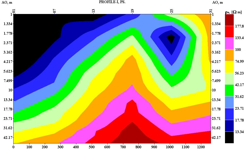
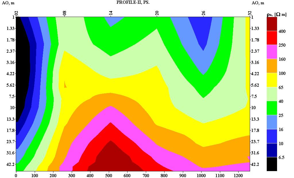
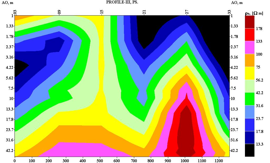
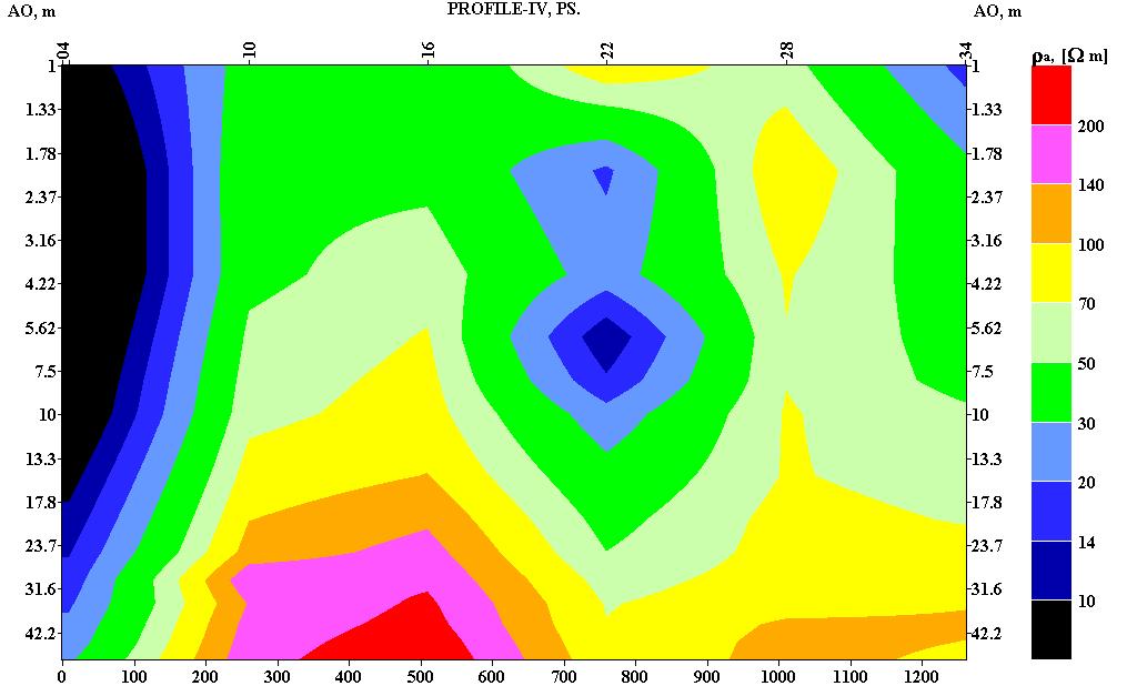
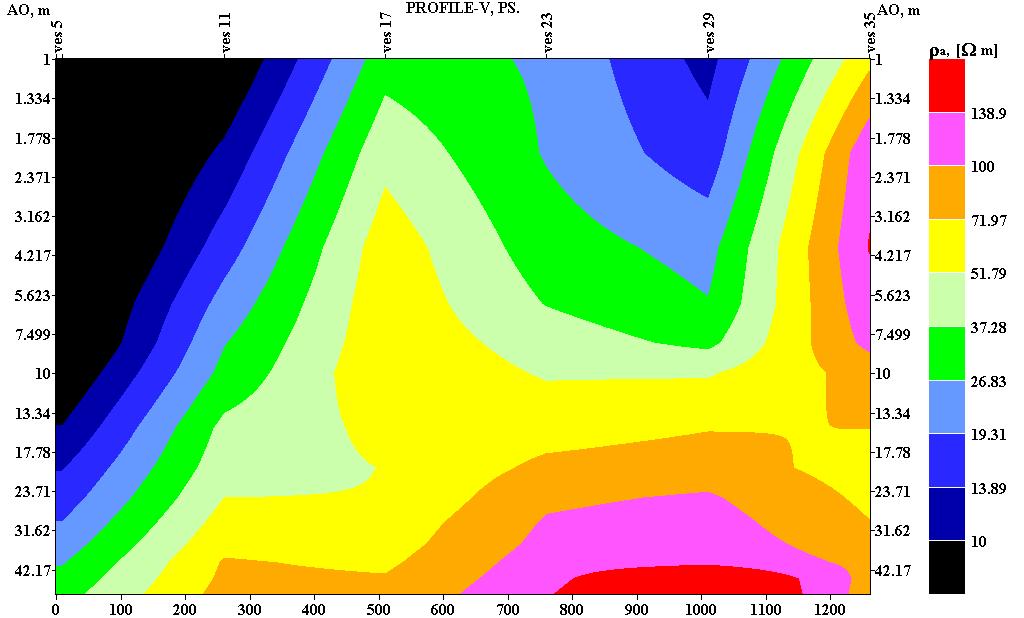
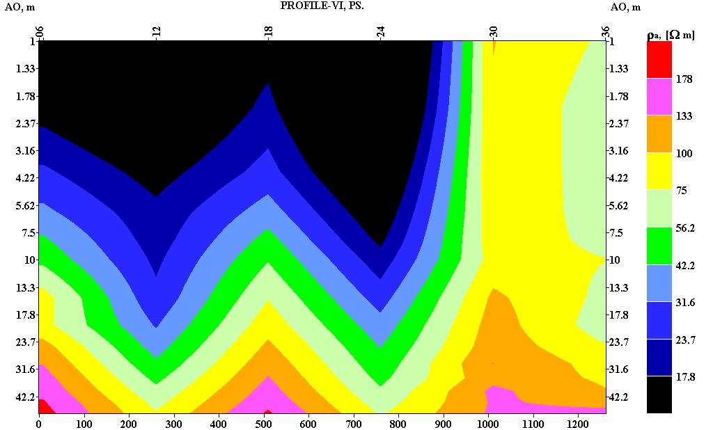
5 Fig.3.Pseudosections of the profiles I to VI 418
6 ISO RESISTIVITY MAP FOR M. ISO RESISTIVITY MAP FOR 6 M AR IN OHM /M AR IN OHM/M TO 50 OHM /M SCALE 1CM = 50M 0 TO 50 OHM / M 50 TO 100 OHM / M SCALE 1CM = 50M 50 TO 100 OHM /M 100 TO 140 OHM /M 100 TO 150 OHM / M VES LOCATIONS VES LOCATIONS ISO RESISTIVITY MAP FOR 10 M ISO RESISTIVITY MAP FOR 15 M AR IN OHM/M 3 AR IN OHM/M SCALE 1 CM = 50M 0 TO 50 OHM / M 50 TO 100 OHM / M 100 TO 150 OHM / M TO 100 OHM / M SCALE : 1 CM = 50 M 100 TO 00 OHM / M 00 TO 60 OHM / M VES LOCATIONS ISO RESISTIVITY MAP FOR 50M VES LOCATIONS ISO RESISTIVITY MAP FOR 0 M AR IN OHM/M 3 AR IN OHM/M TO 150 SCALE 1CM = 50M 150 TO TO 350 VES LOCATION TO 300 SCALE 1CM = 50M 300 TO TO 850 VES LOCATION Fig.4.Isoresistivity maps for the depth of, 6, 10, 15, 0 and 50 m Quality and Quantitative method In the qualitative method the shape of the field curve is critically observed to get an idea qualitatively about the number of layers and the order of resistivities. The thirty six VES curves have been prepared by IPI Win software Program and studied in-depth VES curves of the study 419
7 area. Majority of the curve types are A and AA types of the study area, the other curve types are H, combination of HA and KH types. In the quantitative method geoelectrical parameter i.e., true resistivities and layer thickness are obtained. There are two types of quantitative analysis i) indirect method and ii) direct method. The field curve is compared with album of theoretical curves to get the geoelectrical parameters and this technique is known as curve matching technique. To obtain initial model parameters by indirect method the field curve is matched with standard curves and also by auxiliary point technique [4]. In the direct method the inverse slope technique which is a semi empirical method proposed by [6]. NANGUR, VES 8, BGL ALAMBADI, VES 1, BGL FIRST LAYER - 17 Ω M FIRST LAYER Ω M 0.51 SECOND LAYER -.3 Ω M 0.64 SECOND LAYER Ω M THIRD LAYER Ω M THIRD LAYER Ω M FOURTH LAYER Ω M FOURTH LAYER Ω M THICKNESS IN M FOUERTH LAYER THIRD LAYER SECOND LAYER FIRST LAER THICKNESS IN M FOURTH LAYER THIRD LAYER SECOND LAYER FIRST LAYER Fig.5. Geoelectrical sections RESULT AND DISCUSION The pseudosection profiles (Fig.3.) shows that the southern part of the profiles (station 5 & 31) having high resistivity indicating poor weathering. The low resistivity anomaly extends down to a depth of 31 m. Another low resistivity anomaly is not prominently observed at the southern part i.e. at station 6. Along the station 7 a prominent high resistivity anomaly is observed from the depth of 7m, indicating the massive nature of the rock (Fig.4 & 5). Another low resistivity anomaly is exhibited at station.3, where the low anomaly is sandwitched. Another lower resistivity anomaly is observed between the stations. 3 and 9, the weathering thickness is restricted upto a depth of 5m. There are two high resistivity anomalies observed at station.06 (7.5m) and 18 (7.5m). Isoresistivity contour map showing the high resistivity anomalies at station the prominent low resistivity anomalies observed at stations 1, 15 and 09 indicating a weaker zone along N S direction (Fig.4-6m map). The prominent low resistivity anomaly exhibited in m and 6 m contour maps indicating a prominent weaker zone. From the low resistivity anomalies at a station 1, 35, 36, 4, 1, 13 and 05 indicating a NW SE oriented weaker zone, the high resistivity anomalies at a station 5, 6,, 09, 01 and 06 indicates a massive rock formation (Fig. 4-10m map). The prominent low resistivity anomalies at stations are 1, 36, 1 and 18 indicating a weaker zone along N S direction. High resistivity anomalies at a station 09,, 40
8 and 5 indicate a poorly weathered rock (Fig.4-15m map). The prominent low resistivity anomalies at stations 1,, 36, 1, 18 and 05 indicate N S trending weaker zone and E - W trending weaker zones along station. 1 and (Fig.4-0m map). Figure 4 i.e. 50m map shows the prominent low resistivity anomalies at stations 36,, 18, 1, 11, 05, and 04 indicting a fractured zone along N S direction. VES.08 is KH type curve and VES.1 is AA type curve both are five layered nature, through VES. 1 have very least resistivity, indicating more weathered nature of formation (Fig.5). CONCLUSION Electrical resistivity survey has been carried out at every Km interval in a grid pattern and totally 36 VES were conducted. Pseudosections and isoresistivity maps were generated. Both low and high resistivity anomalies have been demarcated in pseudosection and isoresistivity map. Majority of the VES curves are A and AA types. With multi layered geoelectrical sections. From the pseudosections it may be revealed that the N, NW and NE are comparatively more weathered than the other parts. A prominent low resistivity anomaly has been exhibited at VES.1 in all the six maps indicating more weathered nature of the formation. Based on the hydrogeological condition and geoelectrical resistivity survey findings VES.1 (Alambadi) may be the prospective zone for groundwater development. REFERENCES [1] Ehirim C. N. and C. N. Nwankwo. Archives of Physics Research, 010, (): [] Emmanuel C. Okolie. (010), Archives of Physics Research, 010, 1 (3):6-71. [3] Ogungbe1 A.S, J.A Olowofela, O.O Oresanya1, A.A Alabi., Archives of Physics Research, (010), (): [4] Orellana E, and H. M. Mooney; Master tables and curves for electrical sounding over layered structure interciencia, (Madrid, 1966). [5] Ramanuja chary K. R., and T. Gangadhra Rao; A monograph on groundwater exploration by resistivity, S.P and well logging techniques, (IGIS, 005) Hyderabad. [6]Sanker Narayana P. K. and K. R. Ramanuja Chary; Short notes An inverse slope method of determining absolute resistivity, (Geophysics, 1967) XXXII (6). [7] Senthil Kumar, G.R; Hydrogeological investigations in Tittagudi Taluk, Cuddalore, Tamil Nadu, S. India, (Unpublished thesis of Annamalai University, 006) pp [8] TWAD; Hand book for TWAD Hydrogeologist, (TWAD Board, 00) Chennai. 41
ELECTRICAL RESISTIVITY DATA INTERPRETATION FOR GROUNDWATER DETECTION IN TITTAGUDI TALUK OF CUDDALORE DISTRICT, TAMIL NADU, INDIA
 ELECTRICAL RESISTIVITY DATA INTERPRETATION FOR GROUNDWATER DETECTION IN TITTAGUDI TALUK OF CUDDALORE DISTRICT, TAMIL NADU, INDIA Uwamungu Placide 1, G.R. Senthil Kumar 2 1 M.Phil Research Scholar, Department
Groundwater Exploration In Parts Of Mangu- Halle North-Central Nigeria.
 International Journal of Scientific and Research Publications, Volume 7, Issue 10, October 2017 440 Groundwater Exploration In Parts Of Mangu- Halle North-Central Nigeria. I. Mamuda *, P.M. Akushai **
GROUNDWATER CONFIGURATION IN THE UPPER CATCHMENT OF MEGHADRIGEDDA RESERVOIR, VISAKHAPATNAM DISTRICT, ANDHRA PRADESH
 GROUNDWATER CONFIGURATION IN THE UPPER CATCHMENT OF MEGHADRIGEDDA RESERVOIR, VISAKHAPATNAM DISTRICT, ANDHRA PRADESH Prof.P.Jagadeesara Rao Department of Geo-Engineering and Centre for Remote Sensing, College
Integrated Approach to Delineate Fresh Groundwater Resources around Koganti Powers Ltd., Raichur, Karnataka, India
 5th Conference & Exposition on Petroleum Geophysics, Hyderabad-2004, India PP 937-942 around Koganti Powers Ltd., Raichur, Karnataka, India N.C. Mondal, V.S. Singh & B.A. Prakash National Geophysical Research
Scholars Research Library
 Available online at www.scholarsresearchlibrary.com Scholars Research Library Archives of Physics Research, 2010, 1 (2):37-45 (http://scholarsresearchlibrary.com/archive.html) ISSN 0976-0970 2-D Resistivity
Vertical electrical sounding (VES) for subsurface geophysical investigation in Kanigiri area, Prakasam district, Andhra Pradesh, India
 for subsurface geophysical investigation in Kanigiri area, Prakasam district, Andhra Pradesh, India") Available online at www.pelagiaresearchlibrary.com Advances in Applied Science Research, 2014, 5(5):82-86 ISSN: 0976-8610 CODEN (USA): AASRFC Vertical electrical sounding (VES) for subsurface geophysical
Available online at www.pelagiaresearchlibrary.com Advances in Applied Science Research, 2014, 5(5):82-86 ISSN: 0976-8610 CODEN (USA): AASRFC Vertical electrical sounding (VES) for subsurface geophysical
Scholars Research Library. Geophysical investigation of effects of topographic complexities on groundwater potential in Ibusa, Delta State Nigeria
 Available online at www.scholarsresearchlibrary.com Scholars Research Library Archives of Physics Research, 010, 1 (3):6-71 (http://scholarsresearchlibrary.com/archive.html) ISSN 0976-0970 CODEN (USA):
Palaeoscars and landslide prediction using 2D ERI techniques in Ooty area, Nilgiri district, Tamilnadu
 Available online at www.scholarsresearchlibrary.com Archives of Applied Science Research, 2012, 4 (1):262-268 (http://scholarsresearchlibrary.com/archive.html) ISSN 0975-508X CODEN (USA) AASRC9 Palaeoscars
CHAPTER 9 SUMMARY AND CONCLUSIONS
 CHAPTER 9 SUMMARY AND CONCLUSIONS The following are the important conclusions and salient features of the present study. 1. The evaluation of groundwater potential is a prerequisite for any kind of planning
Characterization of the geology and subsurface crystalline limestone mining using 2D ERI at Puthur Mines, Tirunelveli, Tamilnadu
 Available online at www.scholarsresearchlibrary.com Archives of Applied Science Research, 2012, 4 (3):1261-1265 (http://scholarsresearchlibrary.com/archive.html) ISSN 0975-508X CODEN (USA) AASRC9 Characterization
Groundwater Assessment in Apapa Coast-Line Area of Lagos Using Electrical Resistivity Method
 Journal of Emerging Trends in Engineering and Applied Sciences (JETEAS) 2 (4): 673-679 Scholarlink Research Institute Journals, 2011 (ISSN: 2141-7016) jeteas.scholarlinkresearch.org Groundwater Assessment
Scholars Research Library
 Available online at www.scholarsresearchlibrary.com Scholars Research Library Archives of Applied Science Research, 010, (): 4-34 (http://scholarsresearchlibrary.com/archive.html) ISSN 0975-508X CODEN
GEOELECTRICAL INVESTIGATION OF GROUNDWATER CONDITION IN OLEH, NIGERIA
 www.arpapress.com/volumes/vol15issue1/ijrras_15_1_14.pdf GEOELECTRICAL INVESTIGATION OF GROUNDWATER CONDITION IN OLEH, NIGERIA O. Anomohanran Physics Department, Delta State University, Abraka, Delta State,
MICRO LEVEL GEO-RESISTIVITY SURVEY THROUGH V.E.S. TEST FOR GROUNDWATER FEASIBILITY STUDY AND SELECTION OF BORE WELL SITES IN PIPILI BLOCK OF PURI
 Review of Environment and Earth Sciences 2014 Vol.1, No.2, pp. 37-45 ISSN(e): 2313-8440 ISSN(p): 2409-2150 DOI: 10.18488/journal.80/2014.1.2/80.2.37.45 MICRO LEVEL GEO-RESISTIVITY SURVEY THROUGH V.E.S.
Application of Remote Sensing and Geo-Electrical Method for Groundwater Exploration in Khor Al Alabyad, North Kordofan State, Sudan
 American Journal of Earth Sciences 2015; 2(6): 242-246 Published online January 10, 2016 (http://www.openscienceonline.com/journal/ajes) ISSN: 2381-4624 (Print); ISSN: 2381-4632 (Online) Application of
Geophysical Investigation: A Case Study of Basement Complex, Nigeria
 Geophysical Investigation: A Case Study of Basement Complex, Nigeria Adiela U.P 1, Ayodele Moses Oyewole 2 and Omoirabor Omoleomo 3 1 Department of Petroleum Engineering, Nigerian Agip Oil Company, Port
FIELD IDENTIFICATION OF GROUNDWATER POTENTIAL ZONE BY VES METHOD IN SOUTH MALANG, INDONESIA
 International Journal of Civil Engineering and Technology (IJCIET) Volume 10, Issue 02, February 2019, pp. 999-1009, Article ID: IJCIET_10_02_097 Available online at http://www.iaeme.com/ijciet/issues.asp?jtype=ijciet&vtype=10&itype=02
Groundwater Exploration in Hard Rock Areas of Vizianagaram District, Andhra Pradesh, India
 J. Ind. Geophys. Union ( April 2007 ) Vol.11, No.2, pp.79-90 Groundwater Exploration in Hard Rock Areas of Vizianagaram District, Andhra Pradesh, India S.N.Das, N.C.Mondal 1 and V.S.Singh 1 Action For
Underground water exploration of Oleh, Nigeria using the electrical resistivity method
 Scientific Research and Essays Vol. 6(20), pp. 4295-4300, 19 September, 2011 Available online at http://www.academicjournals.org/sre ISSN 1992-2248 2011 Academic Journals Full Length Research Paper Underground
Subsurface investigations in lower Palar river basin using vertical electrical resistivity surveys
 Subsurface investigations in lower Palar river basin using vertical electrical resistivity surveys K.Parmasivam, G.Vijayakumar and K.K. Sharma Department of Applied Geology, University of Madras, Guindy
INTERNATIONAL JOURNAL OF GEOMATICS AND GEOSCIENCES Volume 3, No 1, 2012
 INTERNATIONAL JOURNAL OF GEOMATICS AND GEOSCIENCES Volume 3, No 1, 2012 Copyright by the authors - Licensee IPA- Under Creative Commons license 3.0 Research article ISSN 0976 4380 Groundwater potential
Analysis of electrical resistivity data for the determination of aquifer depth at Sapele RD in Benin city
 Available online at www.pelagiaresearchlibrary.com Advances in Applied Science Research, 203, 4(6):268-276 ISSN: 0976-860 CODEN (USA): AASRFC Analysis of electrical resistivity data for the determination
RESISTIVITY IMAGING AND BOREHOLE INVESTIGATION OF THE BANTING AREA AQUIFER, SELANGOR, MALAYSIA. A.N. Ibrahim Z.Z.T. Harith M.N.M.
 JOURNAL OF ENVIRONMENTAL HYDROLOGY The Electronic Journal of the International Association for Environmental Hydrology On the World Wide Web at http://www.hydroweb.com VOLUME 11 2003 RESISTIVITY IMAGING
An Assessment of Electrical Resistivity Soundings Data by Different Interpretation Techniques
 International Journal of Biological, Ecological and Environmental Sciences (IJBEES) Vol. 1, No. 3, 212 ISSN 2277 4394 An Assessment of Electrical Resistivity Soundings Data by Different Interpretation
Integration of Thematic Maps Through GIS for Identification of Groundwater Potential zones. Amaresh Kr. Singh & S. Ravi Prakash
 Integration of Thematic Maps Through GIS for Identification of Groundwater Potential zones Amaresh Kr. Singh & S. Ravi Prakash Remote Sensing Applications Centre, U.P., Sector -G, Jankipuram, Lucknow rsacup@sancharnet.in,
The Use of Vertical Electrical Sounding (VES) for Subsurface Geophysical Investigation around Bomo Area, Kaduna State, Nigeria
 for Subsurface Geophysical Investigation around Bomo Area, Kaduna State, Nigeria") IOSR Journal of Engineering (IOSRJEN) e-issn: 2250-3021, p-issn: 2278-8719 Vol. 3, Issue 1 (Jan. 2013), V4 PP 10-15 The Use of Vertical Electrical Sounding (VES) for Subsurface Geophysical Investigation
IOSR Journal of Engineering (IOSRJEN) e-issn: 2250-3021, p-issn: 2278-8719 Vol. 3, Issue 1 (Jan. 2013), V4 PP 10-15 The Use of Vertical Electrical Sounding (VES) for Subsurface Geophysical Investigation
Assessment of Ground Water in a Part of Coastal West Bengal using Geo-Electrical Method
 Vol. 13, No. 2, pp. 203-210 (2013) Journal of Agricultural Physics ISSN 0973-032X http://www.agrophysics.in Research Article Assessment of Ground Water in a Part of Coastal West Bengal using Geo-Electrical
International Journal of Scientific & Engineering Research, Volume 7, Issue 3, March ISSN
 International Journal of Scientific & Engineering Research, Volume 7, Issue 3, March-2016 152 Investigation of Groundwater Resources by Determining the Aquifer Parameters around Futa Staff Quarters C.T.
Research Article Delineation of Fractured Aquifer Using Numerical Analysis (Factor) of Resistivity Data in a Granite Terrain
 of Resistivity Data in a Granite Terrain") International Geophysics, Article ID 585204, 8 pages http://dx.doi.org/10.1155/2014/585204 Research Article Delineation of Fractured Aquifer Using Numerical Analysis (Factor) of Resistivity Data in a Granite
International Geophysics, Article ID 585204, 8 pages http://dx.doi.org/10.1155/2014/585204 Research Article Delineation of Fractured Aquifer Using Numerical Analysis (Factor) of Resistivity Data in a Granite
Electrical prospecting involves detection of surface effects produced by electrical current flow in the ground.
 Electrical Surveys in Geophysics Electrical prospecting involves detection of surface effects produced by electrical current flow in the ground. Electrical resistivity method Induced polarization (IP)
A Hydro-Geophysical Investigation of Groundwater Potential
 International Journal of Engineering Research and Development e-issn: 2278-067X, p-issn: 2278-800X, www.ijerd.com Volume 9, Issue 4 (December 2013), PP. 30-35 A Hydro-Geophysical Investigation of Groundwater
Azimuthal Square Array Configuration and Groundwater Prospecting in Quartzite Terrian at Edaikkal, Ambasamudram, Tirunelveli
 Research Journal of Earth Sciences 4 (2): 49-55, 2012 ISSN 1995-9044 IDOSI Publications, 2012 DOI: 10.5829/idosi.rjes.2012.4.2.2937 Azimuthal Square Array Configuration and Groundwater Prospecting in Quartzite
Geoelectricity. ieso 2010
 Geoelectricity ieso 2010 1 RESISTIVITY SURVEY AT VENETO VILLA GRITTI AT THE TOWN OF TREVISO (VENETO REGION) The survey was carried out to verify the underground presence of the fondations of a rustic building.
GROUNDWATER INVESTIGATION USING GEOPHYSICAL METHODS- A CASE STUDY OF PYDIBHIMAVARAM INDUSTRIAL AREA
 GROUNDWATER INVESTIGATION USING GEOPHYSICAL METHODS- A CASE STUDY OF PYDIBHIMAVARAM INDUSTRIAL AREA G.VenkataRao 1, P.Kalpana 2, R. Srinivasa Rao 3 1,3 Department of Civil Engineering, GMR Institute of
Hydro-Geophysical Investigation of the Federal Housing Estate Akure, Southwestern Nigeria
 Journal of Emerging Trends in Engineering and Applied Sciences (JETEAS) 4(6): 793-799 Scholarlink Research Institute Journals, 2013 (ISSN: 2141-7016) jeteas.scholarlinkresearch.org Journal of Emerging
International Journal of Remote Sensing & Geoscience (IJRSG) ASTER DEM BASED GEOLOGICAL AND GEOMOR-
 ASTER DEM BASED GEOLOGICAL AND GEOMOR-") ASTER DEM BASED GEOLOGICAL AND GEOMOR- PHOLOGICAL INVESTIGATION USING GIS TECHNOLOGY IN KOLLI HILL, SOUTH INDIA Gurugnanam.B, Centre for Applied Geology, Gandhigram Rural Institute-Deemed University, Tamilnadu,
ASTER DEM BASED GEOLOGICAL AND GEOMOR- PHOLOGICAL INVESTIGATION USING GIS TECHNOLOGY IN KOLLI HILL, SOUTH INDIA Gurugnanam.B, Centre for Applied Geology, Gandhigram Rural Institute-Deemed University, Tamilnadu,
Subsurface Characterization using Electrical Resistivity(Dipole-Dipole) method at Lagos State University (LASU) Foundation School, Badagry
 method at Lagos State University (LASU) Foundation School, Badagry") Available online at www.pelagiaresearchlibrary.com Advances in Applied Science Research, 2010, 1 (1): 174-181 Subsurface Characterization using Electrical Resistivity(Dipole-Dipole) method at Lagos State
Available online at www.pelagiaresearchlibrary.com Advances in Applied Science Research, 2010, 1 (1): 174-181 Subsurface Characterization using Electrical Resistivity(Dipole-Dipole) method at Lagos State
Morenikeji P. Anjorin, B.Tech. 1 and Martins O. Olorunfemi, Ph.D. 2*
 A Short Note on Comparative Study of Schlumberger and Half Schlumberger Arrays in Vertical Electrical Sounding in a Basement Complex Terrain of Southwest Nigeria. Morenikeji P. Anjorin, B.Tech. 1 and Martins
CHAPTER 4 METHODOLOGY
 59 CHAPTER 4 METHODOLOGY 4.1 INTRODUCTION The general methodology adopted for the hydrogeological study in Gadilam lower sub basin includes the data collection from various departments on water level,
Ground Water Potential Mapping in Chinnar Watershed (Koneri Sub Watershed) Using Remote Sensing & GIS
 Using Remote Sensing & GIS") Ground Water Potential Mapping in Chinnar Watershed (Koneri Sub Watershed) Using Remote Sensing & GIS T.Velmurugan 1 Dr.D.Srinivasan 2 1 Assistant professor/civil, Roever Engineering College, Perambalur.
Ground Water Potential Mapping in Chinnar Watershed (Koneri Sub Watershed) Using Remote Sensing & GIS T.Velmurugan 1 Dr.D.Srinivasan 2 1 Assistant professor/civil, Roever Engineering College, Perambalur.
Ground Magnetic and Electrical Resistivity Mapping for Basement Structurs over Charnokitic Terrain in Ado-Ekiti Area, Southwestern Nigeria
 International Journal of Science and Technology Volume 3 No. 10, October, 2014 Ground Magnetic and Electrical Resistivity Mapping for Basement Structurs over Charnokitic Terrain in Ado-Ekiti Area, Southwestern
Geophysical investigations for groundwater exploration in a crystalline basement, southwest Nigeria
 Geophysical investigations for groundwater exploration in a crystalline basement, southwest Nigeria Awomeso Awonusi 1, Orebiyi Olabisi 1 and Oyedokun Olabamiji 2. 1 Department of Water Resources Management
Geophysical Investigation of Ground Water Using Vertical Electrical Sounding and Seismic Refraction Methods
 International Journal of Petroleum and Petrochemical Engineering (IJPPE) Volume 2, Issue 1, 2016, PP 6-11 ISSN 2454-7980 (Online) www.arcjournals.org Geophysical Investigation of Ground Water Using Vertical
Evaluation of Subsurface Formation of Pabna District, Bangladesh
 IOSR Journal of Applied Geology and Geophysics (IOSR-JAGG) e-issn: 2321 0990, p-issn: 2321 0982.Volume 1, Issue 4 (Sep. Oct. 2013), PP 30-36 Evaluation of Subsurface Formation of Pabna District, Bangladesh
2-D RESISTIVITY IMAGING SURVEY FOR WATER-SUPPLY TUBE WELLS IN A BASEMENT COMPLEX: A CASE STUDY OF OOU CAMPUS, AGO-IWOYE SW NIGERIA
 2-D RESISTIVITY IMAGING SURVEY FOR WATER-SUPPLY TUBE WELLS IN A BASEMENT COMPLEX: A CASE STUDY OF OOU CAMPUS, AGO-IWOYE SW NIGERIA 1 AYOLABI, Elijah Adebowale. 2 FOLORUNSO, Adetayo Femi. and 3 ARIYO, Stephen
GROUNDWATER EXPLORATION
 CHAPTER 6 GROUNDWATER EXPLORATION 6.1 INTRODUCTION Water is one of the m water is one of the prerequisites for development and industrial growth. In areas where surface water is not available, groundwater
INTERNATIONAL JOURNAL OF GEOMATICS AND GEOSCIENCES Volume 5, No 2, 2014
 INTERNATIONAL JOURNAL OF GEOMATICS AND GEOSCIENCES Volume 5, No 2, 2014 Copyright by the authors - Licensee IPA- Under Creative Commons license 3.0 Research article ISSN 0976 4380 Disposition of aquifer
Geophysics Course Interpreting DC Resistivity Data
 NORAD supported project in MRRD covering Capacity Building and Institutional Cooperation in the field of Hydrogeology for Faryab Province Afghanistan Geophysics Course Interpreting DC Resistivity Data
Geophysical Investigation of Egbeta, Edo State, Nigeria, Using Electrical Resistivity Survey to Assess the Ground water Potential
 368 Geophysical Investigation of Egbeta, Edo State, Nigeria, Using Electrical Resistivity Survey to Assess the Ground water Potential 1 Aigbogun, Christopher O., 1 Adegbite, Joseph, T., 2 Olorunsola,Kuforijimi,
INTEGRATED APPROACH TO DELINEATE THE CONTAMINATED GROUNDWATER IN THE TENNARY BELT: A CASE STUDY
 INTEGRATED APPROACH TO DELINEATE THE CONTAMINATED GROUNDWATER IN THE TENNARY BELT: A CASE STUDY N.C. MONDAL Groundwater Group, National Geophysical Research Institute Hyderabad, Andhra Pradesh-500 007,
GEOELECTRICAL RESISTIVITY SURVEY FOR GROUNDWATER POTENTIAL A CASE STUDY OF NANDI RIVER BASIN, TAMIL NADU, INDIA
 - 1961 - GEOELECTRICAL RESISTIVITY SURVEY FOR GROUNDWATER POTENTIAL A CASE STUDY OF NANDI RIVER BASIN, TAMIL NADU, INDIA PRABHU, K. 1,2* SIVAKUMAR, R. 1 1 Department of Civil Engineering, SRM Institute
[Penumaka, 7(1): January-March 2017] ISSN Impact Factor
![[Penumaka, 7(1): January-March 2017] ISSN Impact Factor](/thumbs/95/124653515.jpg "[Penumaka, 7(1): January-March 2017] ISSN Impact Factor") INTERNATIONAL JOURNAL OF ENGINEERING SCIENCES &MANAGEMENT HYDROGEOMORPHOLOGY OF CHEVELLA BASIN, RANGA REDDY DISTRICT, TELANGANA STATE Penumaka Ramesh* 1 & Podila Sankara Pitchaiah 2 * 1&2 Department of
INTERNATIONAL JOURNAL OF ENGINEERING SCIENCES &MANAGEMENT HYDROGEOMORPHOLOGY OF CHEVELLA BASIN, RANGA REDDY DISTRICT, TELANGANA STATE Penumaka Ramesh* 1 & Podila Sankara Pitchaiah 2 * 1&2 Department of
Delineation of Groundwater Prospective Zones by Schlumberger electrode array in Bangriposi block of Odisha
 International Research Journal of Earth Sciences ISSN 2321 2527 Int. Res.J. Earth Sci. Delineation of Groundwater Prospective Zones by Schlumberger electrode array in Bangriposi block of Odisha Abstract
Hydro-Geophysical Study of River Niger Floodplain at Jebba-North, Nigeria
 Journal of Emerging Trends in Engineering and Applied Sciences (JETEAS) 3 (1): 152-158 Scholarlink Research Institute Journals, 212 (ISSN: 2141-716) jeteas.scholarlinkresearch.org Journal of Emerging Trends
Delineation of groundwater potential zones in Coimbatore district, Tamil Nadu, using Remote sensing and GIS techniques
 Delineation of groundwater potential zones in Coimbatore district, Tamil Nadu, using Remote sensing and GIS techniques Vasudevan S*, MUNGANYINKA Jeanne Pauline, Balamurugan P, Sumanta Kumar Sahoo and Ashis
A case study of crystalline limestone intrusion and fault zone identication using 2d eri technique in Ramco cements, pandalgudi mines, Tamilnadu
 International Research Journal of Geology and Mining (IRJGM) (2276-6618) Vol. 2 (1) pp. 011-015, January 2012 Available online http://www.interesjournals.org/irjgm Copyright 2012 International Research
APPLICATION OF ELECTRICAL RESISTIVITY TOMOGRAPHY FOR SAND UNDERWATER EXTRACTION
 International Scientific Conference GEOBALCANICA 2018 APPLICATION OF ELECTRICAL RESISTIVITY TOMOGRAPHY FOR SAND UNDERWATER EXTRACTION Maya Grigorova Ivaylo Koprev University of Mining and Geology St. Ivan
Hamed Aber 1 : Islamic Azad University, Science and Research branch, Tehran, Iran. Mir Sattar Meshin chi asl 2 :
 Present a Proper Pattern for Choose Best Electrode Array Based on Geological Structure Investigating in Geoelectrical Tomography, in order to Get the Highest Resolution Image of the Subsurface Hamed Aber
Index Terms- Apparent Resistivity, Aquifer, Geoelectric Section, Piezometric Surface.
 Investigation of Groundwater Resources of Rafin Guza Area of Kaduna, Nigeria using Resistivity Method Olaniyan, Isaac O, Olorunnaiye, Emmanuel S. Abstract - The groundwater resources of Rafin Guza village
Adebayo O. Ojo, M.Sc. 1* and Martins O. Olorunfemi, Ph.D *
 A Graphical and Semi-Quantitative Technique for Investigating Vertical Electrical Sounding (VES) Curves for Indices of Confined Fractured Basement Column. Adebayo O. Ojo, M.Sc. 1* and Martins O. Olorunfemi,
WENNER ARRAY RESISTIVITY AND SP LOGGING FOR GROUND WATER EXPLORATION IN SAWERPURAM TERI DEPOSITS, THOOTHUKUDI DISTRICT, TAMIL NADU, INDIA
 WENNER ARRAY RESISTIVITY AND SP LOGGING FOR GROUND WATER EXPLORATION IN SAWERPURAM TERI DEPOSITS, THOOTHUKUDI DISTRICT, TAMIL NADU, INDIA A. Antony Ravindran 1, N. Ramanujam 2 and P. Somasundaram 1 1 Department
CHAPTER 2 GEOLOGY AND GEOMORPHOLOGY
 CHAPTER 2 GEOLOGY AND GEOMORPHOLOGY 2.1 Introduction Groundwater is one among the most precious natural resources. The occurrence and movement of groundwater is directly controlled by the local geological
Geophysical Investigation of Foundation Condition of A Site in Ikere- Ekiti, Ekiti State, South-Western Nigeria
 Australian Journal of Basic and Applied Sciences, 5(9): 1852-1857, 2011 ISSN 1991-8178 Geophysical Investigation of Foundation Condition of A Site in Ikere- Ekiti, Ekiti State, South-Western Nigeria 1
INTERNATIONAL JOURNAL OF GEOMATICS AND GEOSCIENCES Volume 3, No 3, 2013
 INTERNATIONAL JOURNAL OF GEOMATICS AND GEOSCIENCES Volume 3, No 3, 2013 Copyright by the authors - Licensee IPA- Under Creative Commons license 3.0 Research article ISSN 0976 4380 Role of Remote Sensing
Elijah Adebowale Ayolabi, Ph.D. 1, Adetayo Femi Folorunso, M.Sc. 2*, Ayodele Franklin Eleyinmi, B.Sc. 1, and Esther O. Anuyah, B.Sc.
 Applications of 1D and 2D Electrical Resistivity Methods to Map Aquifers in a Complex Geologic Terrain of Foursquare Camp, Ajebo, Southwestern Nigeria. Elijah Adebowale Ayolabi, Ph.D. 1, Adetayo Femi Folorunso,
AN INTEGRATED GEOPHYSICAL INVESTIGATION OF A SPRING IN IBUJI, IGBARA-OKE, SOUTHWESTERN NIGERIA.
 Ife Journal of Science vol. 13, no. 1 (2011) AN INTEGRATED GEOPHYSICAL INVESTIGATION OF A SPRING IN IBUJI, IGBARA-OKE, SOUTHWESTERN NIGERIA. 63 Bayode S. * and Akpoarebe O. Department of Applied Geophysics,
International Journal of Modern Trends in Engineering and Research e-issn No.: , Date: April, 2016
 International Journal of Modern Trends in Engineering and Research www.ijmter.com e-issn No.:2349-9745, Date: 28-30 April, 2016 Landslide Hazard Management Maps for Settlements in Yelwandi River Basin,
Electrical Resistivity studies for Groundwater exploration in the some parts Chopda block of Jalgaon District, Maharashtra India
 International Research Journal of Earth Sciences ISS 2321 2527 Electrical Resistivity studies for Groundwater exploration in the some parts Chopda block of Jalgaon District, Maharashtra India Abstract
ELECTRICAL RESISTIVITY TOMOGRAPHY
 NOTIO Association Clay Technological Centre C/ Río Cabriel s/n 45007 Toledo Tel.: 925 24 11 62 info@notio.es www.notio.es Page 1 / 7 SUMMARY 1. PHYSICAL FUNDAMENTALS OF THE... 3 1.1. ELECTRICAL BEHAVIOR
Case Study: University of Connecticut (UConn) Landfill
 Landfill") Case Study: University of Connecticut (UConn) Landfill Problem Statement:» Locate disposal trenches» Identify geologic features and distinguish them from leachate and locate preferential pathways in fractured
Case Study: University of Connecticut (UConn) Landfill Problem Statement:» Locate disposal trenches» Identify geologic features and distinguish them from leachate and locate preferential pathways in fractured
EVALUATION OF GROUND WATER POTENTIAL OF NALLATANGAAL ODAI USING REMOTE SENSING AND GIS TECHNIQUES
 EVALUATION OF GROUND WATER POTENTIAL OF NALLATANGAAL ODAI USING REMOTE SENSING AND GIS TECHNIQUES Rishabh Tripathi, Shyju K and Jasim H.R,, Bharathidasan University Abstract Ground water is the source
Application of Vertical Electrical Sounding to Delineate and Evaluate the Hydrological Conditions in Baiji Tikrit Basin
 Application of Vertical Electrical Sounding to Delineate and Evaluate the Hydrological Conditions in Baiji Tikrit Basin Muhanna Mitaab Ahmed Zaidoon Taha Abdulrazzaq Sabbar Abdullah Salih Department of
Investigation of Underground Water at Paiko Using Vertical Electrical Sounding Technique in Paiko, Nigeria
 Investigation of Underground Water at Paiko Using Vertical Electrical Sounding Technique in Paiko, Nigeria Mamman H. Mamman and Ojo T. John Department of Science Technology, Federal Polytechnic, Ado-Ekiti,
INTERNATIONAL JOURNAL OF GEOMATICS AND GEOSCIENCES Volume 1, No 3, 2010
 Integrated analysis of Geophysical Data of Ponnaiyar river basin using Arcview GIS Software Ruby.D 1, Chitra.C 1, Vasantha.A 1, Ramasubbulakshmi.T 1, Manivel.M 2 1 Research Scholar, Department of Geology,
FUNDAMENTALS OF ENGINEERING GEOLOGY
 FUNDAMENTALS OF ENGINEERING GEOLOGY Prof. Dr. HUSSEIN HAMEED KARIM Building and Construction Engineering Department 2012 Preface The impulse to write this book stemmed from a course of geology given by
*S.VE KATESWARA, **S.VASUDEVA *S.KARUPA A, *T.GAJALAKSHMI
 GIS A ALYSIS OF GROU D TRUTH, GPS A D GEOPHYSICAL DATA FOR IDE TIFICATIO OF SUITABLE LOCALES OF RAI WATER HARVESTI G: A CASE OF PERIYAR U IVERSITY CAMPUS, SALEM DISTRICT, SOUTH I DIA *Mu.RAMKUMAR, *S.VE
S.I. Fadele, M.Sc. 1 ; P.O. Sule, Ph.D. 1 ; and B.B.M. Dewu, Ph.D * ABSTRACT
 The Use of Vertical Electrical Sounding (VES) for Groundwater Exploration around Nigerian College of Aviation Technology (NCAT), Zaria, Kaduna State, Nigeria. S.I. Fadele, M.Sc. 1 ; P.O. Sule, Ph.D. 1
EVALUATION OF GROUNDWATER POTENTIAL USING ELECTRICAL RESISTIVITY METHOD IN OKENUGBO AREA, AGO - IWOYE, SOUTHWESTERN, NIGERIA.
 EVALUATION OF GROUNDWATER POTENTIAL USING ELECTRICAL RESISTIVITY METHOD IN OKENUGBO AREA, AGO - IWOYE, SOUTHWESTERN, NIGERIA. OLADUNJOYE H.T., 1 ODUNAIKE R.K., 1 OGUNSOLA P 1. OLALEYE O.A. 2 1 DEPARTMENT
SUITABILITY OF ELECTRICAL RESISTIVITY SURVEY FOR SELECTING ANICUT SITE IN ORDER TO AUGMENT GROUND WATER A CASE STUDY
 Annals of Arid Zone 30 (3) : 187-195, 1991 SUTABLTY OF ELECTRCAL RESSTVTY SURVEY FOR SELECTNG ANCUT STE N ORDER TO AUGMENT GROUND WATER A CASE STUDY J.P. SHUKLA* and S.M. PANDEY Ground Water Department,
2D Resistivity Imaging Investigation of Solid Waste Landfill Sites in Ikhueniro Municipality, Ikpoba Okha Local Government Area,Edo State, Nigeria.
 2D Resistivity Imaging Investigation of Solid Waste Landfill Sites in Ikhueniro Municipality, Ikpoba Okha Local Government Area,Edo State, Nigeria. Iyoha. A, Akhirevbulu O.E, Amadasun C.V.O and Evboumwan
REMOTE SENSING AND GIS BASED APPROACH FOR DELINEATION OF ARTIFICIAL RECHARGE SITES IN PALANI TALUK, DINDIGUL DISTRICT, TAMILNADU, INDIA
 International Journal of Civil Engineering and Technology (IJCIET) Volume 8, Issue 8, August 2017, pp. 698 706, Article ID: IJCIET_08_08_070 Available online at http://http://www.iaeme.com/ijciet/issues.asp?jtype=ijciet&vtype=8&itype=8
CHARACTERIZATION OF SOIL PROFILE OF DHAKA CITY USING ELECTRICAL RESISTIVITY TOMOGRAPHY (ERT)
") CHARACTERIZATION OF SOIL PROFILE OF DHAKA CITY USING ELECTRICAL RESISTIVITY TOMOGRAPHY (ERT) Mehedi Ahmed ANSARY 1, B.S. Pushpendue BISWAS 2 and Abul KHAIR 3 1 Professor, Department of Civil Engineering
CHARACTERIZATION OF SOIL PROFILE OF DHAKA CITY USING ELECTRICAL RESISTIVITY TOMOGRAPHY (ERT) Mehedi Ahmed ANSARY 1, B.S. Pushpendue BISWAS 2 and Abul KHAIR 3 1 Professor, Department of Civil Engineering
Site Characterization Studies Using Electrical Resistivity Technique in Gudwanwadi Dam Site, Karjat, Maharashtra PROJECT REPORT
 Site Characterization Studies Using Electrical Resistivity Technique in Gudwanwadi Dam Site, Karjat, Maharashtra PROJECT REPORT Submitted for the Partial fulfillment of the requirement for the degree of
Delineation of aquifers in basaltic hard rock terrain using vertical electrical soundings data
 Delineation of aquifers in basaltic hard rock terrain using vertical electrical soundings data SNRai, S Thiagarajan, Y Ratna Kumari, V Anand Rao and A Manglik CSIR National Geophysical Research Institute,
Groundwater Sustainability at Wadi Al Bih Dam, Ras El Khaimah, United Arab Emirates (UAE) using Geophysical methods
 using Geophysical methods") Groundwater Sustainability at Wadi Al Bih Dam, Ras El Khaimah, United Arab Emirates (UAE) using Geophysical methods Ahmed Murad, Amir Gabr, Saber Mahmoud, Hasan Arman & Abdulla Al Dhuhoori Geology Department
Groundwater Sustainability at Wadi Al Bih Dam, Ras El Khaimah, United Arab Emirates (UAE) using Geophysical methods Ahmed Murad, Amir Gabr, Saber Mahmoud, Hasan Arman & Abdulla Al Dhuhoori Geology Department
Study on Bromide in Groundwater in Parts of Nalgonda District, Andhra Pradesh
 e-journal Earth Science India, Vol. 3 (I), January, 2010, pp.73-80 http://www.earthscienceindia.info/; ISSN: 0974 8350 Study on Bromide in Groundwater in Parts of Nalgonda District, Andhra Pradesh K. Brindha
2-D Resistivity Study: The Horizontal Resolution Improvement by Introducing the Enhancing Horizontal Resolution (EHR) Technique
 Technique") Open Journal of Geology, 213, 3, 1-6 doi:1.4236/ojg.213.32b1 Published Online April 213 (http://www.scirp.org/journal/ojg) 2-D Resistivity Study: The Horizontal Resolution Improvement by Introducing the
Open Journal of Geology, 213, 3, 1-6 doi:1.4236/ojg.213.32b1 Published Online April 213 (http://www.scirp.org/journal/ojg) 2-D Resistivity Study: The Horizontal Resolution Improvement by Introducing the
Geological and Geophysical Investigation of Groundwater in Parts of Paiko, Sheet 185, North-Central Nigeria
 International Journal of Engineering Research and Development e-issn: 2278-067X, p-issn: 2278-800X, www.ijerd.com Volume 6, Issue 1 (February 2013), PP. 01-08 Geological and Geophysical Investigation of
Comparison of GIS based SCS-CN and Strange table Method of Rainfall-Runoff Models for Veeranam Tank, Tamil Nadu, India.
 International Journal of Scientific & Engineering Research, Volume 3, Issue 10, October-2012 1 Comparison of GIS based SCS-CN and Strange table Method of Rainfall-Runoff Models for Veeranam Tank, Tamil
Hydrogeophysical investigation in selected parts of Irepodun/Ifelodun local government area of Ekiti State, Southwestern Nigeria
 Vol. 5(7), pp. 200-207, July, 2013 DOI: 10.5897/JGMR2013.0183 ISSN 2006 9766 2013 Academic Journals http://www.academicjournals.org/jgmr Journal of Geology and Mining Research Full Length Research Paper
Vertical Electrical Sounding (Ves) For The Determination Of Under Ground Resistivity In Part Of Nigeria Wilberforce Island,Amassoma, Bayelsa State
 For The Determination Of Under Ground Resistivity In Part Of Nigeria Wilberforce Island,Amassoma, Bayelsa State") IOSR Journal of Research & Method in Education (IOSR-JRME) e-issn: 2320 7388,p-ISSN: 2320 737X Volume 7, Issue 2 Ver. III (Mar. - Apr. 2017), PP 53-61 www.iosrjournals.org Vertical Electrical Sounding
IOSR Journal of Research & Method in Education (IOSR-JRME) e-issn: 2320 7388,p-ISSN: 2320 737X Volume 7, Issue 2 Ver. III (Mar. - Apr. 2017), PP 53-61 www.iosrjournals.org Vertical Electrical Sounding
Electrical imaging techniques for hydrological and risk assessment studies
 Séminaire IPG le 9 mars 2006 Strasbourg Institute of Geophysics ETH Hoenggerberg CH-8093 Zurich Electrical imaging techniques for hydrological and risk assessment studies Laurent Marescot laurent@aug.ig.erdw.ethz.ch
Geophysics Course Introduction to DC Resistivity
 NORAD supported project in MRRD covering Capacity Building and Institutional Cooperation in the field of Hydrogeology for Faryab Province Afghanistan Geophysics Course Introduction to DC Resistivity By
Electrical Resistivity Survey for Delineating Seawater Intrusion in a Coastal Aquifer
 Electrical Resistivity Survey for Delineating Seawater Intrusion in a Coastal Aquifer Sung-Ho Song*, Gyu-Sang Lee*, Jin-Sung Kim*, Baekuk Seong*, Young-gyu Kim*, Myung-Ha Woo* and Namsik Park** Abstract
3D Electrical Resistivity Tomography (ERT) Survey of a Typical Basement Complex Terrain
 Survey of a Typical Basement Complex Terrain") Journal of Emerging Trends in Engineering and Applied Sciences (JETEAS) 2 (4): 680-686 Scholarlink Research Institute Journals, 2011 (ISSN: 2141-7016) jeteas.scholarlinkresearch.org Journal of Emerging
Journal of Emerging Trends in Engineering and Applied Sciences (JETEAS) 2 (4): 680-686 Scholarlink Research Institute Journals, 2011 (ISSN: 2141-7016) jeteas.scholarlinkresearch.org Journal of Emerging
Geophysical Investigation of the Precambrian Marble Occurrence in Itobe Area, Central Nigeria
 British Journal of Applied Science & Technology 4(13): 1891-1904, 2014 SCIENCEDOMAIN international www.sciencedomain.org Geophysical Investigation of the Precambrian Marble Occurrence in Itobe Area, Central
FINAL REPORT GEOPHYSICAL INVESTIGATION VILLAGE ALHAMBRA RETENTION POND SITE THE VILLAGES, FLORIDA
 FINAL REPORT GEOPHYSICAL INVESTIGATION VILLAGE ALHAMBRA RETENTION POND SITE THE VILLAGES, FLORIDA Prepared for Andreyev Engineering, Inc. Oxford, FL Prepared by GeoView, Inc. St. Petersburg, FL August
Relevance of 2D Electrical Imaging in Subsurface Mapping: Case Study of National Animal Production Research Institute (NAPRI), Zaria.
, Zaria.") Relevance of 2D Electrical Imaging in Subsurface Mapping: Case Study of National Animal Production Research Institute (NAPRI), Zaria. S.I. Fadele, Ph.D. (in view) 1* ; J. Adamu, M.Sc. 2 ; N.O. Patrick,
Relevance of 2D Electrical Imaging in Subsurface Mapping: Case Study of National Animal Production Research Institute (NAPRI), Zaria. S.I. Fadele, Ph.D. (in view) 1* ; J. Adamu, M.Sc. 2 ; N.O. Patrick,
1. Resistivity of rocks
 RESISTIVITY 1) Resistivity of rocks 2) General principles of resistivity surveying 3) Field procedures, interpretation and examples 4) Summary and conclusions INDUCED POLARIZATION 1) General principles
GSJ: Volume 6, Issue 4, April 2018, Online: ISSN
 GSJ: Volume 6, Issue 4, APRIL 2018 252 GSJ: Volume 6, Issue 4, April 2018, Online: ISSN 2320-9186 VERTICAL ELECTRICAL SOUNDING INVESTIGATION FOR GROUNDWATER DEVELOPMENT IN A CRYSTALLINE BASEMENT COMPLEX