GROUNDWATER EXPLORATION
|
|
|
- Ronald Blankenship
- 5 years ago
- Views:
Transcription
1 CHAPTER 6 GROUNDWATER EXPLORATION 6.1 INTRODUCTION Water is one of the m water is one of the prerequisites for development and industrial growth. In areas where surface water is not available, groundwater constitutes significant part of active fresh water resources of the world and is obviously dependable source for all the needs. The stress on water resources started due to exploding population, irrigation, domestic and industrial demands. The finite water resources are being explored to quench the thirst of millions of the populace. Although the groundwater resources are widely distributed, nature does not provide groundwater at the places of our choice. The occurrence and distribution of groundwater resources are confined to certain geological formations and structures. The groundwater at all locations may not be directly used if the quality of water is poor. All these problems can be solved using proper exploration techniques. The proper exploration of groundwater resources involves apart from source location, the well design and construction. These are all an integral part of the scheme of exploitation and management. 6.2 GROUNDWATER EXPLORATION Groundwater exploration in past years has reached a place of importance to the world and supplying groundwater to the needy is most precious of all. Prospecting for water is essentially a geological problem and the geophysical approach is dependent on the mode of the geological occurrence of water. It needs a lot of information on various aspects such as geology, stratigraphy, geomorphology, geophysical techniques, etc. Geology is the most important consideration, as different rock types will generally have a distinctive porosity and permeability. Knowledge of stratigraphy is essential to know the position and thickness of water-bearing horizons and the continuity of confining beds are of particular importance in groundwater exploration. Structural geology is used in conjunction with stratigraphy to locate water-bearing horizons which have been displaced by earth movements. Structural studies are also used to locate weathered, fractured, faulted and jointed patterns in rock formations. Remote sensing techniques are particularly helpful in many geomorphic and structural studies related to hydrology. The remote sensing data are found extremely useful in identifying 115
2 the various geologic, geomorphic units, structures such as faults, lineaments, joints, fractures, folds and drainage which are important as they control the movement and occurrence of groundwater. Geomorphology is indispensable in studying the occurrence of subsurface water in areas of late Pleistocene to recent deposits. After a thorough study of the satellite imagery and geomorphology map, a field check is highly necessary to know the geomorphological features to assess the groundwater potential. The geomorphic units such as pediments, flood plains, drainage pattern, soil types and lineaments which primarily control the occurrence, movement and potential of groundwater have to be investigated in detail. The groundwater potential of an area mainly depends on the hydrogeological set up, for which a detailed and systematic hydrogeological survey is a prerequisite. Well inventory study is very important in any groundwater exploration programme. Especially in hard rock terrain groundwater confines to the weathered mantle, joints and fractures. The weathering thickness, joint and fracture system of the area ought to be studied in depth. Water level measurements and water level fluctuation studies are the important factors in the assessment of groundwater potential. Only by a systematic hydrogeological study, the groundwater abstracting structures such as open well, bore well, tube well have to be finalised. The recharge and discharge areas ought to be identified. The fluvial hydrological studies such as the river and stream flows, whether it is perennial and other details are important in quantifying the potential. Geophysical methods such as electrical, electromagnetic, seismic and gravity are used to explore the groundwater. Geophysically, the location of groundwater may be determined in three ways: direct, stratigraphic and structural (Bhattacharya and Patra, 1968; Elijah A. Ayolabi, 2005). The stratigraphic method which is relevant to this study implies locating water-bearing formations through distinguishing physical properties imparted by the presence of water, giving rise to electrical resistivity contrasts. The electrical resistivity methods give fairly accurate results in groundwater investigation. Electrical resistivity methods assumed considerable importance in the field of groundwater exploration (Pal and Majumdar, 2001; Majumdar and Pal, 2005; Narayanpethkar et al., 2006) because of its inexpensive, easy operation and its capacity to identify between fresh and saline water zones, the method is used worldwide. The resistivity methods are used successfully to estimate the thickness of the formation and also the electrical nature of the formation which provides useful information regarding 116
3 the groundwater potentialities (Griffiths and King, 1965; Parasins, 1966; Balakrishna, 1980) Electrical Resistivity Method Many methods have been adopted for the exploration of groundwater among them Electrical Resistivity Method is used at most throughout the world. The basic principle of the electrical methods of exploration for groundwater is based on the concept of resistivity. All the geological formation posses a property called resistivity which determines the ease in which the electrical current flows through them. Resistivity may be defined as the resistance offered by a unit cube of the material, when a unit current passes through it in a direction perpendicular to two of its opposite faces. The terms resistivity and resistance are related by the equation =R(A/L), where, R is the resistance, L is the length of the block and A is the cross-sectional area of the block. The resistivity - m ( -m), The unit of resistance Thus the resistivity ( ) of a regular block can be determined by measuring its resistance (R), which is given by V/I, where, V is the potential difference or voltage between the two ends of the medium and I is the current (Kaul et al., 1990) Application of Resistivity Methods in Hard Rock Terrains Different types of geological materials have different resistivity. The resistivity of the geological formation depends mainly on its porosity, moisture content, quantity of water, salinity of water and electrical property of the rock itself governed by the preferred orientation of constituent minerals. Therefore, the measured resistivity will facilitate in the estimate of weathered zone thickness, extent of weathering, depth of the massive rock, quality of water and delineate the sheared and fractured zones, structures such as dykes, faults and lateral extent of aquifers Field Methods In resistivity surveys, electrical current is sent into the ground through two electrodes known as current electrodes and the resulting potentials are measured with the help of two other electrodes known as potential electrodes. The measured apparent resistivity ( ) for each half- a lowing formula: 117
4 where, is apparent resistivity, K is the factor depending on the geometry of electrode configuration, V is the voltage measured across potential electrodes and I is the current sent into the ground. The apparent resistivity for a given electrode separation may vary within wide limits depending upon the nature of surface material. The direction of electrode spread in relation to anisotropic characters and lateral inhomogeneities etc. The apparent resistivity map for a given electrode spacing indicates the variation of resistivity in the subsurface layer with a thickness approximately equal to electrode spacing (Zohdy et al., 1974). There are two main variations of resistivity surveys, namely profiling and vertical Electrical Sounding (VES). Profiling is used to determine the lateral variation of resistivity from area to area, whereas VES is used to investigate the vertical variations of rock strata in a given location Resistivity Profiling Electrical profiling investigations are conducted in order to trace lateral boundaries of lithological units having different electrical properties. In this method the electrode separation is kept constant and the setup is moved from point to point and apparent resistivities are determined for each station. In practice, uniformly distributed locations will serve the purpose. For a given spacing the depth of penetration is propositional to the spacing. For registering lateral discontinuities at depth, it is need to use large electrode spacing. In practice, a minimum of two spacing are used for profiling, one for shallow and other for deeper exploration. The apparent resistivity values for a given electrode spacing are plotted and contoured to prepare Iso-resistivity maps. The zones of high and low apparent resistivity areas are marked to give an idea about the epicentral location of the target and its lateral extent. Profiling is useful in areas where the subsurface formations are horizontal or nearly horizontal and posses sufficient resistivity contrast (Mooney et al., 1966). In groundwater prospecting, the resistivity profiling is useful in the following situations: To identify and mapping conductive zones in high resistivity hard rock areas To identify gravel formation which acts as good alluvial aquifer tracks To identify and mapping structures such as faults, joints, shear zones, fractures, dykes and lineaments in hard rock areas To demarcate salt/fresh water boundaries (sea water intrusions in coastal areas) To detect favourable hydrological horizons, palaeo-river channels, buried river valleys, groundwater pollution zones, etc. 118
5 Determining the direction and intensity of joints and fractures (Murali Sabnavis and Patangay, 1998) In general, the low resistivity zones in hard rock areas and a higher resistivity zone in sedimentary formations help to distinguish clay beds from sand beds. Fault zones and structurally disturbed zones also show relatively low resistivity Vertical Electrical Sounding VES method is used to investigate the vertical variation in electrical property of the formation. In resistivity sounding method the centre of the electrode configuration is kept fixed and the distance between current electrodes called the electrode separation is increased in steps and measurements are made for each electrode separation. The depth of penetration increases with the increase of electrode separation. The apparent resistivity values obtained with increasing values of electrode separation are used to estimate the thickness and resistivities of the subsurface formations. The measured resistivity values can be correlated with vertical geological sections Electrode Configuration In the exploration of groundwater by resistivity methods, there are number of ways of setting up of current and potential electrodes. The choice of an array and the distance between the electrodes is very important for obtaining the best possible information on the subsurface geology of a given area. Keller and Frischnecht (1966) have described different configurations viz, Schlumberger, Wenner, Dipole Dipole, Trielectrode, Lee-partitioning, etc. The Schlumberger method in particular has practical, operational and interpretational advantages over the rest of the methods (Bhimasankaram, 1977). The maximum current electrode spacing depends on the depth to be investigated in a given situation Schlumberger Electrode Configuration The Schlumberger configuration is most widely used for quantitative interpretation in VES. Schlumberger originally proposed this electrode arrangement. Four electrodes are placed symmetrically along a common line with the outer two serving as current electrodes and the inner two as potential electrodes. The inner pair of potential electrodes (MN) is located at the centre of the array and the separation between them is small compared to the current electrode distance (AB), usually less 119
6 than one-fifth of the current electrode distance (Fig. 6.1). The apparent resistivity values obtained with this array are attributed to the midpoint of configuration, which is called as completely uniform earth is given by the formula (Keller and Frischnecht, 1966) where, = apparent resistivity, V = potential difference between potential electrodes, I = current flowing, AB = current electrodes, MN = potential electrodes Wenner Configuration In this configuration, four equally spaced and collinear electrodes are used. The outer current electrodes (A and B) provide current to the ground, whereas the inner two potential electrodes (M and N) are used to measure the voltage drop due to earth held fixed and all four electrodes being separated by equal distances at all times (Fig. 6.2). The apparent resistivity for this type of electrode arrangement is given by (Keller and Frischnecht, 1966) the formula: a 2 a V I where, a = Apparent resistivity, a = Distance between two electrodes, V = Potential difference between potential electrode and I = Current sent into the ground Resistivity in Hard Rock Terrains The typical hydrogeological section of a hard rock terrain consists of a soil zone followed by a weathered zone are overlying bedrock, which is fractured to varying degrees. Weathered zone is more permeable than bedrock and an appreciable portion of the available groundwater is stored in that zone. The fractures, joints and other openings present in the rock act as conduits for circulation of groundwater rather than for accumulation. However, these structures under favourable situations act as potential zones of groundwater accumulation. According to Narasimhan (1972), the occurrence of groundwater beyond a depth of about 70 m below ground level is not significant due to the tendency of joints, fissures and other such openings to tightly close down at that depth. 120
7 However, there are several instances of potential groundwater accumulation at much deeper levels. The thickness of water-bearing zones of weathered and semiweathered layer is variable. Their resistivities vary from 30 to 200 -m. Such low resistivity regions indicate potential groundwater zones. Depending on the degree of jointing, granite with full of joints and cracks filled with water may show resistivities of the order of 50 to 250 -m (Ramachandra Rao, 1975). Ramanujacharya (1974) and Balakrishna (1980) have given the following general resistivity range for granitic terrains: Formation Representative Resistivity Range ( -m) Highly weathered layer Semiweathered layer Fractured and jointed granites Hard granites > RESISTIVITY SURVEYS IN THE STUDY AREA Fifty-one VES have been carried out at different parts of the study area using Schlumberger method of electrode configuration by using Aqua Meter to determine the groundwater potential zones of the study area. The resistivity meter is placed at an observation station, which is suitable for spreading the cable on either direction. The electrodes for measuring on the potential difference are placed on either side of the chosen point. Two current electrodes are driven into the ground to 10 to 15 cm deep on either side of the centre. These current electrodes are connected to instrument. The electrical connections and separations are checked before each measurement. The apparent resistivity value is determined by sending current (I) into the ground and measuring the potential drop (V/I) ratio multiplied by configuration current (K). The electrode spacing (AB) is then increased and the corresponding apparent resistivity value is measured. The operation is repeated again and again whereas the current electrodes are extended further away from the centre, keeping the potential electrodes (porous pots) stationary. When the potential difference value becomes very small, the distance between the potential electrodes are increased. After this increase, the apparent resistivity can be measured for increasing current electrode separations using the larger potential electrode separation. The apparent resistivity with Schlumberger electrode configuration is computed by using the formula: 121
8 2 2 a where, AB = Distance between current electrodes, MN = Distance between potential electrodes, V = Voltage measured across potential electrodes and I = Current flowing. The VES data have been used to determine the thickness and resistivity values of weathered, semiweathered and fractured layers Interpretation of Field Curves The interpretation of resistivity sounding data in terms of thickness and resistivity of the underlying beds with reasonable limit of accuracy is difficult problem. For a correct interpretation of geoelectrical sounding curves, a sound knowledge in geology of the area, some borehole data and considerable practical experience are essential. Geoelectrical sounding curves are interpreted qualitatively in terms of geology of the area. The qualitative methods of interpretation can be used only for preliminary interpretation as explained by Mooney et al. (1966), Bhattacharya and Patra (1968). There are several methods of interpretation of VES data, in the present study curve matching technique is used Curve Matching Method The curve matching technique is used to determine the layer parameters from the VES curves. The field curves are matched with standard curves to get the layer parameters. Several such standard curves are available viz, Mooney et al. (1966), Zohdy (1968) and Rajkswterstaat (1975). In this study layer parameters have been obtained by using IPI2WIN ware. The layer parameters obtained by the analysis are presented in the Table 6.1. The VES curves obtained are of three layered, the top most layers have the resistivity values ranging from 12 to 65 -m and its thickness ranges 1.2 to 1.9 m. This variation in the resistivity values due to the local conditions such as, soil moisture content. The resistivity of the second layer varies between 12 to m and the thickness ranges between 4.5 to 15.5 m, this layer corresponds to weathered layer. The third layer generally represents the semiweathered/fractured rocks exhibiting resistivity values ranges from 36 to 385 -m. In some cases, the third layer represents the compact hard bed rock. 122
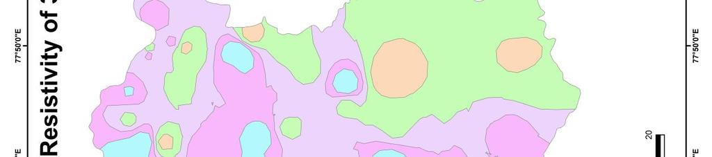
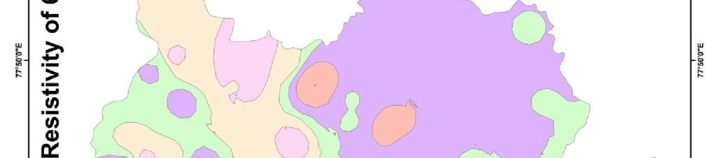
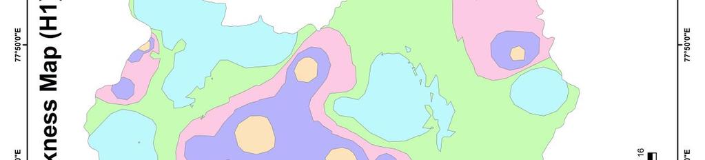
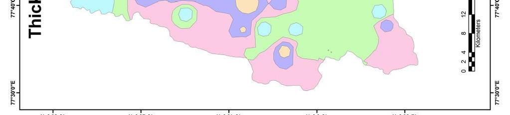
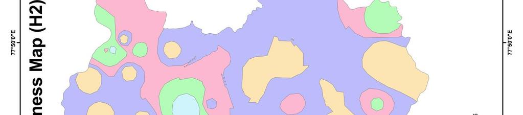
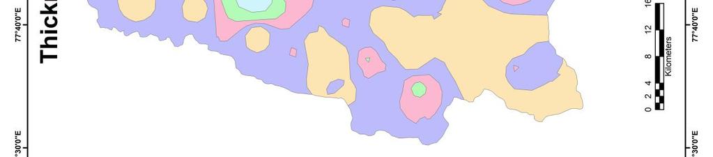
9 6.3.3 Iso-Resisitivity Maps Iso-resistivity maps of the study area prepared by contouring the apparent resistivity values, corresponding to the electrode spacing (AB/2) of 30 and 60 m by using ArcGIS 9.3 software. These maps are helpful in delineating low apparent resistivity zones and are favourable locations for groundwater storage, provided the weathered layer is sufficiently thick and permeable. The apparent resistivity values ranges from 14 to 65 -m and 45 to110 -m (Table 6.1) at 30 and 60m electrode spacing, respectively. The Iso-resistivity maps for both 30 and 60 m electrode spacing indicates (Maps 6.1 and 6.2) that the high resistivity values have been found in northern (Nandi), northeastern (Jangamakote), western (Devanahalli), southern (Sarjapura and Dommasandra) and southeastern (Sulibele) parts of the study area. The high resistivity values in these areas are due to the presence of massive bedrock at shallow depth and absence of water-bearing zones. The remaining part of the study area have moderate to low apparent resistivity and these regions are promising zones for groundwater development. The north and eastern part of the study area found patches of lateritic outcrops. In these areas a sudden fall in apparent resistivity, indicates the contact zone of lateritic and basement massive weathered rock found gravel layer, it shows a moderate to good amount of groundwater potential and are prospective zones for further development in the study area Iso-Thickness Maps The thickness of soil and weathered layers are also very important from the point of groundwater potential zones, as the percolation of rainwater is mainly controlled by these layers. The thickness of the first (h 1 ) and second (h 2 ) layers are varies from 1.2 to 1.9 m with an average of 1.65 m. The thickness of second layer varies from 4.5 to 15.5 m and an average of 8.23 m. The variation in the thickness mainly due to the variation in lithology and landforms. The Iso-thickness map of h 1 and h 2 (Maps 6.3 and 6.4) shows the anomalous zones in northern, western, central, southern and southeastern parts of the study area. The lithologies of these anomalous zones are weathered gneisses and granites. They have more chance for infiltration of rainwater and are the potential zones of groundwater. 123
10 6.3.5 Total Longitudinal Conductance Map Determination of total longitudinal conductance (S) provides an important check on the curve interpretation and can be used for the preparation of S-map. The total longitudinal conductance has been determined from the slope of the terminal branch of the sounding curve called S-line, rising at an angle of 45 to the AB/2 axis (Zohdy et al., 1974). If the S-line is extended back to intersect the a = 1 -m line, then the intersect point on the x-axis is equal to S, the total longitudinal conductance above the final layer S in mohs or Siemens (Murali Sabnavis and S the slope of this line (Keller and Frischnecht, 1966). When a number of layers are involved in a geo S S = S 1 + S 2 + S 3 + S 4 + S 5 +, where, S 1 = h 1 / 1 In this S IPI2WIN software and values are presented in the Table 6.1. The longitudinal conductance in the study area varies from 0.35 to 0.96 mhos. The spatial variation of S-map indicates that the high values are noticed in northern, western, central, southern and southeastern parts of the study area indicating good aquifer conditions (Map 6.5). The increase in the S values indicates the decrease in the overall resistivity of the formations and increase in the thickness of overburden. High values of S can be considered as an important index of groundwater potential. 124
11 Sl. No. Location Table 6.1 Layer Parameters for the VES Data Resistivity of Different Thickness of Total Apparent Layers ( -m) Layers (m) S Thickness Resistivity at (Mhos) h 1 h 2 (m) 30 m 60 m 1 Nandhi Bendiganahalli Siddlaghatta Gottigere Meluru Vijayapura Chikkaballapura Avathi Jangamakote Venkatapura Devanahalli Keshavara Mallur Anneswara Sugatta Hosahudya Kogilu Sulibele Bagalur Kodigehalli Hunsamaranahalli Patrenahalli Keshavapura Dommasandra Mugulur Keshavapura Mangammanapalya K. Narayanapura Muddenahalli
12 Sl. No. Location Resistivity of Different Thickness of Total Apparent Layers ( -m) Layers (m) S Thickness Resistivity at (Mhos) h 1 h 2 (m) 30 m 60 m 30 Kanithahalli Begur Sarjapura Mandur Nagavara Nagenahalli Gantiganahalli Jakkur Budigere Devaganahalli Doddagubbi Hoshigal Yelahanka Singasandra Bilekahalli Bidarahalli Navarthna Agrahara Hosakote Chikkajala Laksandra Karahalli Jakkur
13
14
15 Map 6.5 Iso-Longitudinal Conductance Map the Study Area 129
16 Figure 6.1 Schlumberger Electrode Configuration A, B: Current electrodes; M, N: Potential electrodes; O: Midpoint; V: Voltmeter; A: Ammeter Figure 6.2 Wenner Electrode Configuration 130
Groundwater Sustainability at Wadi Al Bih Dam, Ras El Khaimah, United Arab Emirates (UAE) using Geophysical methods
 using Geophysical methods") Groundwater Sustainability at Wadi Al Bih Dam, Ras El Khaimah, United Arab Emirates (UAE) using Geophysical methods Ahmed Murad, Amir Gabr, Saber Mahmoud, Hasan Arman & Abdulla Al Dhuhoori Geology Department
Groundwater Sustainability at Wadi Al Bih Dam, Ras El Khaimah, United Arab Emirates (UAE) using Geophysical methods Ahmed Murad, Amir Gabr, Saber Mahmoud, Hasan Arman & Abdulla Al Dhuhoori Geology Department
MICRO LEVEL GEO-RESISTIVITY SURVEY THROUGH V.E.S. TEST FOR GROUNDWATER FEASIBILITY STUDY AND SELECTION OF BORE WELL SITES IN PIPILI BLOCK OF PURI
 Review of Environment and Earth Sciences 2014 Vol.1, No.2, pp. 37-45 ISSN(e): 2313-8440 ISSN(p): 2409-2150 DOI: 10.18488/journal.80/2014.1.2/80.2.37.45 MICRO LEVEL GEO-RESISTIVITY SURVEY THROUGH V.E.S.
Vertical electrical sounding (VES) for subsurface geophysical investigation in Kanigiri area, Prakasam district, Andhra Pradesh, India
 for subsurface geophysical investigation in Kanigiri area, Prakasam district, Andhra Pradesh, India") Available online at www.pelagiaresearchlibrary.com Advances in Applied Science Research, 2014, 5(5):82-86 ISSN: 0976-8610 CODEN (USA): AASRFC Vertical electrical sounding (VES) for subsurface geophysical
Available online at www.pelagiaresearchlibrary.com Advances in Applied Science Research, 2014, 5(5):82-86 ISSN: 0976-8610 CODEN (USA): AASRFC Vertical electrical sounding (VES) for subsurface geophysical
GROUNDWATER CONFIGURATION IN THE UPPER CATCHMENT OF MEGHADRIGEDDA RESERVOIR, VISAKHAPATNAM DISTRICT, ANDHRA PRADESH
 GROUNDWATER CONFIGURATION IN THE UPPER CATCHMENT OF MEGHADRIGEDDA RESERVOIR, VISAKHAPATNAM DISTRICT, ANDHRA PRADESH Prof.P.Jagadeesara Rao Department of Geo-Engineering and Centre for Remote Sensing, College
2-D RESISTIVITY IMAGING SURVEY FOR WATER-SUPPLY TUBE WELLS IN A BASEMENT COMPLEX: A CASE STUDY OF OOU CAMPUS, AGO-IWOYE SW NIGERIA
 2-D RESISTIVITY IMAGING SURVEY FOR WATER-SUPPLY TUBE WELLS IN A BASEMENT COMPLEX: A CASE STUDY OF OOU CAMPUS, AGO-IWOYE SW NIGERIA 1 AYOLABI, Elijah Adebowale. 2 FOLORUNSO, Adetayo Femi. and 3 ARIYO, Stephen
Application of Remote Sensing and Geo-Electrical Method for Groundwater Exploration in Khor Al Alabyad, North Kordofan State, Sudan
 American Journal of Earth Sciences 2015; 2(6): 242-246 Published online January 10, 2016 (http://www.openscienceonline.com/journal/ajes) ISSN: 2381-4624 (Print); ISSN: 2381-4632 (Online) Application of
Geoelectricity. ieso 2010
 Geoelectricity ieso 2010 1 RESISTIVITY SURVEY AT VENETO VILLA GRITTI AT THE TOWN OF TREVISO (VENETO REGION) The survey was carried out to verify the underground presence of the fondations of a rustic building.
APPLICATION OF ELECTRICAL RESISTIVITY TOMOGRAPHY FOR SAND UNDERWATER EXTRACTION
 International Scientific Conference GEOBALCANICA 2018 APPLICATION OF ELECTRICAL RESISTIVITY TOMOGRAPHY FOR SAND UNDERWATER EXTRACTION Maya Grigorova Ivaylo Koprev University of Mining and Geology St. Ivan
RESISTIVITY IMAGING AND BOREHOLE INVESTIGATION OF THE BANTING AREA AQUIFER, SELANGOR, MALAYSIA. A.N. Ibrahim Z.Z.T. Harith M.N.M.
 JOURNAL OF ENVIRONMENTAL HYDROLOGY The Electronic Journal of the International Association for Environmental Hydrology On the World Wide Web at http://www.hydroweb.com VOLUME 11 2003 RESISTIVITY IMAGING
The Use of Vertical Electrical Sounding (VES) for Subsurface Geophysical Investigation around Bomo Area, Kaduna State, Nigeria
 for Subsurface Geophysical Investigation around Bomo Area, Kaduna State, Nigeria") IOSR Journal of Engineering (IOSRJEN) e-issn: 2250-3021, p-issn: 2278-8719 Vol. 3, Issue 1 (Jan. 2013), V4 PP 10-15 The Use of Vertical Electrical Sounding (VES) for Subsurface Geophysical Investigation
IOSR Journal of Engineering (IOSRJEN) e-issn: 2250-3021, p-issn: 2278-8719 Vol. 3, Issue 1 (Jan. 2013), V4 PP 10-15 The Use of Vertical Electrical Sounding (VES) for Subsurface Geophysical Investigation
Identification of aquifer zones by VES method: A case study from Mangalore block, Tamil Nadu, S. India
 Available online at www.scholarsresearchlibrary.com Scholars Research Library Archives of Applied Science Research, 011, 3 ():414-41 (http://scholarsresearchlibrary.com/archive.html) ISSN 0975-508X CODEN
Surface Processes Focus on Mass Wasting (Chapter 10)
") Surface Processes Focus on Mass Wasting (Chapter 10) 1. What is the distinction between weathering, mass wasting, and erosion? 2. What is the controlling force in mass wasting? What force provides resistance?
Surface Processes Focus on Mass Wasting (Chapter 10) 1. What is the distinction between weathering, mass wasting, and erosion? 2. What is the controlling force in mass wasting? What force provides resistance?
Scholars Research Library. Geophysical investigation of effects of topographic complexities on groundwater potential in Ibusa, Delta State Nigeria
 Available online at www.scholarsresearchlibrary.com Scholars Research Library Archives of Physics Research, 010, 1 (3):6-71 (http://scholarsresearchlibrary.com/archive.html) ISSN 0976-0970 CODEN (USA):
Evaluation of Subsurface Formation of Pabna District, Bangladesh
 IOSR Journal of Applied Geology and Geophysics (IOSR-JAGG) e-issn: 2321 0990, p-issn: 2321 0982.Volume 1, Issue 4 (Sep. Oct. 2013), PP 30-36 Evaluation of Subsurface Formation of Pabna District, Bangladesh
CHAPTER 9 SUMMARY AND CONCLUSIONS
 CHAPTER 9 SUMMARY AND CONCLUSIONS The following are the important conclusions and salient features of the present study. 1. The evaluation of groundwater potential is a prerequisite for any kind of planning
International Journal of Basic and Applied Sciences Raibu et. al., Vol. 1 No. 2 ISSN: (A peer reviewed International Journal)
") (A peer reviewed International Journal) Determination of Aquifer Layer by the Application of Electrical Resistivity and Electromagnetic Method of Exploration at Ojoo Town Oyo State Southwestern Nigeria
(A peer reviewed International Journal) Determination of Aquifer Layer by the Application of Electrical Resistivity and Electromagnetic Method of Exploration at Ojoo Town Oyo State Southwestern Nigeria
Groundwater Exploration In Parts Of Mangu- Halle North-Central Nigeria.
 International Journal of Scientific and Research Publications, Volume 7, Issue 10, October 2017 440 Groundwater Exploration In Parts Of Mangu- Halle North-Central Nigeria. I. Mamuda *, P.M. Akushai **
11/22/2010. Groundwater in Unconsolidated Deposits. Alluvial (fluvial) deposits. - consist of gravel, sand, silt and clay
 deposits. - consist of gravel, sand, silt and clay") Groundwater in Unconsolidated Deposits Alluvial (fluvial) deposits - consist of gravel, sand, silt and clay - laid down by physical processes in rivers and flood plains - major sources for water supplies
Groundwater in Unconsolidated Deposits Alluvial (fluvial) deposits - consist of gravel, sand, silt and clay - laid down by physical processes in rivers and flood plains - major sources for water supplies
DATA ACQUISITION METHODS FOR GROUNDWATER INVESTIGATION AND THE SITING OF WATER SUPPLY WELLS
 DATA ACQUISITION METHODS FOR GROUNDWATER INVESTIGATION AND THE SITING OF WATER SUPPLY WELLS M.B.J. Foster Tetra Tech EM Inc., San Francisco, CA, USA Keywords: Groundwater, water wells, drilled wells, geophysical
ELECTRICAL RESISTIVITY TOMOGRAPHY
 NOTIO Association Clay Technological Centre C/ Río Cabriel s/n 45007 Toledo Tel.: 925 24 11 62 info@notio.es www.notio.es Page 1 / 7 SUMMARY 1. PHYSICAL FUNDAMENTALS OF THE... 3 1.1. ELECTRICAL BEHAVIOR
2-D Resistivity Study: The Horizontal Resolution Improvement by Introducing the Enhancing Horizontal Resolution (EHR) Technique
 Technique") Open Journal of Geology, 213, 3, 1-6 doi:1.4236/ojg.213.32b1 Published Online April 213 (http://www.scirp.org/journal/ojg) 2-D Resistivity Study: The Horizontal Resolution Improvement by Introducing the
Open Journal of Geology, 213, 3, 1-6 doi:1.4236/ojg.213.32b1 Published Online April 213 (http://www.scirp.org/journal/ojg) 2-D Resistivity Study: The Horizontal Resolution Improvement by Introducing the
HYDROGEOLOGICAL PROPERTIES OF THE UG2 PYROXENITE AQUIFERS OF THE BUSHVELD COMPLEX
 R. Gebrekristos, P.Cheshire HYDROGEOLOGICAL PROPERTIES OF THE UG2 PYROXENITE AQUIFERS OF THE BUSHVELD COMPLEX R. Gebrekristos Digby Wells Environmental P. Cheshire Groundwater Monitoring Services Abstract
AN INTEGRATED GEOPHYSICAL INVESTIGATION OF A SPRING IN IBUJI, IGBARA-OKE, SOUTHWESTERN NIGERIA.
 Ife Journal of Science vol. 13, no. 1 (2011) AN INTEGRATED GEOPHYSICAL INVESTIGATION OF A SPRING IN IBUJI, IGBARA-OKE, SOUTHWESTERN NIGERIA. 63 Bayode S. * and Akpoarebe O. Department of Applied Geophysics,
Geophysical Investigation: A Case Study of Basement Complex, Nigeria
 Geophysical Investigation: A Case Study of Basement Complex, Nigeria Adiela U.P 1, Ayodele Moses Oyewole 2 and Omoirabor Omoleomo 3 1 Department of Petroleum Engineering, Nigerian Agip Oil Company, Port
G. Barrocu G. Ranieri Faculty of Engineering, University of Cagliari, Italy. In the region of Muravera, south-east coast of Sardinia, the trend of
 HYDROGEOLOGICAL AND GEOPHYSICAL INVESTIGATIONS FOR EVALUATING SALT INTRUSION PHENOMENA IN SARDINIA G. Barbieri G. Barrocu G. Ranieri Faculty of Engineering, University of Cagliari, Italy Abstract In the
Hydro-Geophysical Investigation of the Federal Housing Estate Akure, Southwestern Nigeria
 Journal of Emerging Trends in Engineering and Applied Sciences (JETEAS) 4(6): 793-799 Scholarlink Research Institute Journals, 2013 (ISSN: 2141-7016) jeteas.scholarlinkresearch.org Journal of Emerging
Azimuthal Square Array Configuration and Groundwater Prospecting in Quartzite Terrian at Edaikkal, Ambasamudram, Tirunelveli
 Research Journal of Earth Sciences 4 (2): 49-55, 2012 ISSN 1995-9044 IDOSI Publications, 2012 DOI: 10.5829/idosi.rjes.2012.4.2.2937 Azimuthal Square Array Configuration and Groundwater Prospecting in Quartzite
R.Suhasini., Assistant Professor Page 1
 UNIT I PHYSICAL GEOLOGY Geology in civil engineering branches of geology structure of earth and its composition weathering of rocks scale of weathering soils - landforms and processes associated with river,
SEISMIC REFRACTION INVESTIGATION OF THE SUBSURFACE STRUCTURE AT THE SOUTHERN PART OF NIGER STATE COLLEGE OF EDUCATION, MINNA, NIGERIA
 Bayero Journal of Pure and Applied Sciences, 3(2): 56-6 Received: May, 200 Accepted: October, 200 ISSN 2006-6996 SEISMIC REFRACTION INVESTIGATION OF TE SUBSURFACE STRUCTURE AT TE SOUTERN PART OF NIGER
1. Resistivity of rocks
 RESISTIVITY 1) Resistivity of rocks 2) General principles of resistivity surveying 3) Field procedures, interpretation and examples 4) Summary and conclusions INDUCED POLARIZATION 1) General principles
Groundwater Assessment in Apapa Coast-Line Area of Lagos Using Electrical Resistivity Method
 Journal of Emerging Trends in Engineering and Applied Sciences (JETEAS) 2 (4): 673-679 Scholarlink Research Institute Journals, 2011 (ISSN: 2141-7016) jeteas.scholarlinkresearch.org Groundwater Assessment
Subsurface Characterization using Electrical Resistivity(Dipole-Dipole) method at Lagos State University (LASU) Foundation School, Badagry
 method at Lagos State University (LASU) Foundation School, Badagry") Available online at www.pelagiaresearchlibrary.com Advances in Applied Science Research, 2010, 1 (1): 174-181 Subsurface Characterization using Electrical Resistivity(Dipole-Dipole) method at Lagos State
Available online at www.pelagiaresearchlibrary.com Advances in Applied Science Research, 2010, 1 (1): 174-181 Subsurface Characterization using Electrical Resistivity(Dipole-Dipole) method at Lagos State
Chapter 8 Fetter, Applied Hydrology 4 th Edition, Geology of Groundwater Occurrence
 Chapter 8 Fetter, Applied Hydrology 4 th Edition, 2001 Geology of Groundwater Occurrence Figure 8.42. Alluvial Valleys ground-water region. Fetter, Applied Hydrology 4 th Edition, 2001 Fetter, Applied
2) First Order Resistivity Effects. The first order effects discussed above in the main reflect vertical resistivity features. (1) Surficial Zone (R3)
 First Order Resistivity Effects. The first order effects discussed above in the main reflect vertical resistivity features. (1) Surficial Zone (R3)") The first and second order effects represent clear and obvious features in the data, while the third order effects are subtle, appearing real and consistent, but on the limit of interpretability. A number
The first and second order effects represent clear and obvious features in the data, while the third order effects are subtle, appearing real and consistent, but on the limit of interpretability. A number
Assessment of Ground Water in a Part of Coastal West Bengal using Geo-Electrical Method
 Vol. 13, No. 2, pp. 203-210 (2013) Journal of Agricultural Physics ISSN 0973-032X http://www.agrophysics.in Research Article Assessment of Ground Water in a Part of Coastal West Bengal using Geo-Electrical
Geophysical Exploration in Water Resources Assessment. John Mundell, P.E., L.P.G., P.G. Ryan Brumbaugh, L.P.G. Mundell & Associates, Inc.
 Geophysical Exploration in Water Resources Assessment John Mundell, P.E., L.P.G., P.G. Ryan Brumbaugh, L.P.G. Mundell & Associates, Inc. Presentation Objective Introduce the use of geophysical survey methods
Groundwater Level Monitoring of the Quaternary Aquifer at Al Ain City, United Arab Emirates (UAE) using Geophysical Methods
 using Geophysical Methods") Groundwater Level Monitoring of the Quaternary Aquifer at Al Ain City, United Arab Emirates (UAE) using Geophysical Methods Ahmed Murad & Amir Gabr Geology Department UAE University Outlines Introduction
Groundwater Level Monitoring of the Quaternary Aquifer at Al Ain City, United Arab Emirates (UAE) using Geophysical Methods Ahmed Murad & Amir Gabr Geology Department UAE University Outlines Introduction
INTEGRATED INVESTIGATION TO LOCATE A WASTE DISPOSAL AREA
 INTEGRATED INVESTIGATION TO LOCATE A WASTE DISPOSAL AREA 1 FOR OIL DRILLING PRODUCTS G. APOSTOLOPOULOS 2, K. PAVLOPOULOS 3, C. ANTONIADES 4, I. LOUIS 5 and C. VLACHOU 4 Nestoros 1, 17564 P.Faliron, Athens,
CONTENTS 1. INTRODUCTION. 2. THE D.C. RESISTIVITY METHOD 2.1 Equipment 2.2 Survey Procedure 2.3 Data Reduction
 (i) CONTENTS 1. INTRODUCTION page 1 2. THE D.C. RESISTIVITY METHOD 2.1 Equipment 2.2 Survey Procedure 2.3 Data Reduction 3 3 3 3 3. GEOPHYSICAL RESULTS 3.1 General 3.2 Discussion 4 4 4 4. LIMITATIONS 5
Case Study: University of Connecticut (UConn) Landfill
 Landfill") Case Study: University of Connecticut (UConn) Landfill Problem Statement:» Locate disposal trenches» Identify geologic features and distinguish them from leachate and locate preferential pathways in fractured
Case Study: University of Connecticut (UConn) Landfill Problem Statement:» Locate disposal trenches» Identify geologic features and distinguish them from leachate and locate preferential pathways in fractured
Geophysics Course Introduction to DC Resistivity
 NORAD supported project in MRRD covering Capacity Building and Institutional Cooperation in the field of Hydrogeology for Faryab Province Afghanistan Geophysics Course Introduction to DC Resistivity By
Integrated Approach to Delineate Fresh Groundwater Resources around Koganti Powers Ltd., Raichur, Karnataka, India
 5th Conference & Exposition on Petroleum Geophysics, Hyderabad-2004, India PP 937-942 around Koganti Powers Ltd., Raichur, Karnataka, India N.C. Mondal, V.S. Singh & B.A. Prakash National Geophysical Research
Soils, Hydrogeology, and Aquifer Properties. Philip B. Bedient 2006 Rice University
 Soils, Hydrogeology, and Aquifer Properties Philip B. Bedient 2006 Rice University Charbeneau, 2000. Basin Hydrologic Cycle Global Water Supply Distribution 3% of earth s water is fresh - 97% oceans 1%
Geophysics for Environmental and Geotechnical Applications
 Geophysics for Environmental and Geotechnical Applications Dr. Katherine Grote University of Wisconsin Eau Claire Why Use Geophysics? Improve the quality of site characterization (higher resolution and
FUNDAMENTALS OF ENGINEERING GEOLOGY
 FUNDAMENTALS OF ENGINEERING GEOLOGY Prof. Dr. HUSSEIN HAMEED KARIM Building and Construction Engineering Department 2012 Preface The impulse to write this book stemmed from a course of geology given by
ambiguity in earth sciences IESO Geophysics Section Eddy hartantyo, Lab Geofisika FMIPA UGM
 ambiguity in earth sciences IESO Geophysics Section Eddy hartantyo, Lab Geofisika FMIPA UGM Pelatihan Tahap II IESO Teknik Geologi UGM Februari 2009 1 Introduction Photos from http://www.eegs.org/whatis/
Springshed Springshed Management Training Curriculum
 Springshed Springshed Management Training Curriculum Management Training Curriculum Draft Version 2 January 2016 The Springs Initiative 2016 The Springs Initiative SESSION TITLE: Mapping Springs in Crystalline
A surficial. P^HiHI waste disposal site, Bureau County, Illinois. east of the Sheffield low-level radioactive. electrical resistivity survey
 ISGS CONTRACT/GRANT REPORT 1981-6 WATER RESOURCES DIVISION/USGS P^HiHI 100240 557.09773 IL6cr 1981-6 A surficial electrical resistivity survey east of the Sheffield low-level radioactive waste disposal
INTEGRATED GEOPHYSICAL INVESTIGATION OF SEQUENCE OF DEPOSITION OF SEDIMENTARY STRATA IN ABAKALIKI, NIGERIA ABSTRACT
 INTEGRATED GEOPHYSICAL INVESTIGATION OF SEQUENCE OF DEPOSITION OF SEDIMENTARY STRATA IN ABAKALIKI, NIGERIA Agha S.O Dept. of Industrial Physics Ebonyi State University, Abakaliki, Nigeria & Arua A.I Dept.
Electrical Resistivity Survey for Delineating Seawater Intrusion in a Coastal Aquifer
 Electrical Resistivity Survey for Delineating Seawater Intrusion in a Coastal Aquifer Sung-Ho Song*, Gyu-Sang Lee*, Jin-Sung Kim*, Baekuk Seong*, Young-gyu Kim*, Myung-Ha Woo* and Namsik Park** Abstract
CE6301 ENGINEERING GEOLOGY UNIT I 2 MARKS
 YEAR : II SEMESTER : III DEPARTMENT : CIVIL CE6301 ENGINEERING GEOLOGY UNIT I 1. What is Physical weathering? 2. Define Stratigraphy and Palaeontology? 3. What is meant by chemical weathering 4. Describe
Vertical Electrical Sounding (Ves) For The Determination Of Under Ground Resistivity In Part Of Nigeria Wilberforce Island,Amassoma, Bayelsa State
 For The Determination Of Under Ground Resistivity In Part Of Nigeria Wilberforce Island,Amassoma, Bayelsa State") IOSR Journal of Research & Method in Education (IOSR-JRME) e-issn: 2320 7388,p-ISSN: 2320 737X Volume 7, Issue 2 Ver. III (Mar. - Apr. 2017), PP 53-61 www.iosrjournals.org Vertical Electrical Sounding
IOSR Journal of Research & Method in Education (IOSR-JRME) e-issn: 2320 7388,p-ISSN: 2320 737X Volume 7, Issue 2 Ver. III (Mar. - Apr. 2017), PP 53-61 www.iosrjournals.org Vertical Electrical Sounding
International Journal of Scientific & Engineering Research, Volume 7, Issue 3, March ISSN
 International Journal of Scientific & Engineering Research, Volume 7, Issue 3, March-2016 152 Investigation of Groundwater Resources by Determining the Aquifer Parameters around Futa Staff Quarters C.T.
Determination of Thickness of Aquifer with Vertical Electrical Sounding
 IOSR Journal of Mechanical and Civil Engineering (IOSR-JMCE) e-issn: 2278-1684,p-ISSN: 2320-334X, Volume 12, Issue 6 Ver. IV (Nov. - Dec. 2015), PP 52-56 www.iosrjournals.org Determination of Thickness
Analysis of electrical resistivity data for the determination of aquifer depth at Sapele RD in Benin city
 Available online at www.pelagiaresearchlibrary.com Advances in Applied Science Research, 203, 4(6):268-276 ISSN: 0976-860 CODEN (USA): AASRFC Analysis of electrical resistivity data for the determination
INTERNATIONAL JOURNAL OF GEOMATICS AND GEOSCIENCES Volume 1, No 3, 2010
 Integrated analysis of Geophysical Data of Ponnaiyar river basin using Arcview GIS Software Ruby.D 1, Chitra.C 1, Vasantha.A 1, Ramasubbulakshmi.T 1, Manivel.M 2 1 Research Scholar, Department of Geology,
K. A. Murana, P. Sule, A.L. Ahmed, E.M. Abraham and E.G. Obande. 1. Introduction
 Subsurface stratigraphic mapping using geoelectric method and its impact on development in Federal College of Education (technical) Gusau, Zamfara State, Nigeria K. A. Murana, P. Sule, A.L. Ahmed, E.M.
 12 10 8 6 4 2 0 40-50 50-60 60-70 70-80 80-90 90-100 Fresh Water What we will cover The Hydrologic Cycle River systems Floods Groundwater Caves and Karst Topography Hot springs Distribution of water in
Vertical Electrical Sounding Survey for Groundwater Exploration in Parts of Anyigba and its Environs, in the Anambra Basin of Nigeria
 British Journal of Applied Science & Technology 4(): 978-988, 204 SCIENCEDOMAIN international www.sciencedomain.org Vertical Electrical Sounding Survey for Groundwater Exploration in Parts of and its Environs,
Electrical prospecting involves detection of surface effects produced by electrical current flow in the ground.
 Electrical Surveys in Geophysics Electrical prospecting involves detection of surface effects produced by electrical current flow in the ground. Electrical resistivity method Induced polarization (IP)
High Resolution Geophysics: A Better View of the Subsurface. By John Jansen, P.G., Ph.D., Aquifer Science and Technology
 High Resolution Geophysics: A Better View of the Subsurface By John Jansen, P.G., Ph.D., Aquifer Science and Technology Geologist Use Only Part of the Information Available To Them Most Geologist rely
Hydro-Geophysical Study of River Niger Floodplain at Jebba-North, Nigeria
 Journal of Emerging Trends in Engineering and Applied Sciences (JETEAS) 3 (1): 152-158 Scholarlink Research Institute Journals, 212 (ISSN: 2141-716) jeteas.scholarlinkresearch.org Journal of Emerging Trends
Integrated Geophysical Interpretation On The Groundwater Aquifer (At The North Western Part of Sinai, Egypt)
") Integrated Geophysical Interpretation On The Groundwater Aquifer (At The North Western Part of Sinai, Egypt) Sultan Awad Sultan Araffa 1, Hassan S. Sabet 2, Ahmed M, Al Dabour 3 1 National Research Institute
Integrated Geophysical Interpretation On The Groundwater Aquifer (At The North Western Part of Sinai, Egypt) Sultan Awad Sultan Araffa 1, Hassan S. Sabet 2, Ahmed M, Al Dabour 3 1 National Research Institute
Utility of the 2-D Multi-Electrode Resistivity Imaging Technique in Groundwater Exploration in the Voltaian Sedimentary Basin, Northern Ghana
 Natural Resources Research, Vol. 18, No. 4, December 2009 (Ó 2009) DOI: 10.1007/s11053-009-9102-4 Utility of the 2-D Multi-Electrode Resistivity Imaging Technique in Groundwater Exploration in the Voltaian
Lima Project: Seismic Refraction and Resistivity Survey. Alten du Plessis Global Geophysical
 Lima Project: Seismic Refraction and Resistivity Survey Alten du Plessis Global Geophysical Report no 0706/2006 18 December 2006 Lima Project: Seismic Refraction and Resistivity Survey by Alten du Plessis
GROUNDWATER INVESTIGATION USING GEOPHYSICAL METHODS- A CASE STUDY OF PYDIBHIMAVARAM INDUSTRIAL AREA
 GROUNDWATER INVESTIGATION USING GEOPHYSICAL METHODS- A CASE STUDY OF PYDIBHIMAVARAM INDUSTRIAL AREA G.VenkataRao 1, P.Kalpana 2, R. Srinivasa Rao 3 1,3 Department of Civil Engineering, GMR Institute of
LECTURE 10. Module 3 : Field Tests in Rock 3.6 GEOPHYSICAL INVESTIGATION
 LECTURE 10 3.6 GEOPHYSICAL INVESTIGATION In geophysical methods of site investigation, the application of the principles of physics are used to the study of the ground. The soil/rock have different characteristics
Adebayo O. Ojo, M.Sc. 1* and Martins O. Olorunfemi, Ph.D *
 A Graphical and Semi-Quantitative Technique for Investigating Vertical Electrical Sounding (VES) Curves for Indices of Confined Fractured Basement Column. Adebayo O. Ojo, M.Sc. 1* and Martins O. Olorunfemi,
Enhanced Characterization of the Mississippi River Valley Alluvial Aquifer Using Surface Geophysical Methods
 Photo by Shane Stocks, U.S. Geological Survey Enhanced Characterization of the Mississippi River Valley Alluvial Aquifer Using Surface Geophysical Methods Presented by Ryan F. Adams US Geological Survey
Relevance of Geophysics in Road Failures Investigation in a Typical Basement Complex of Southwestern Nigeria.
 Relevance of Geophysics in Road Failures Investigation in a Typical Basement Complex of Southwestern Nigeria. K.A.N. Adiat, M.Tech. *, A.O. Adelusi, Ph.D., and M.A. Ayuk, M.Tech. Department of Applied
[Penumaka, 7(1): January-March 2017] ISSN Impact Factor
![[Penumaka, 7(1): January-March 2017] ISSN Impact Factor](/thumbs/95/124653515.jpg "[Penumaka, 7(1): January-March 2017] ISSN Impact Factor") INTERNATIONAL JOURNAL OF ENGINEERING SCIENCES &MANAGEMENT HYDROGEOMORPHOLOGY OF CHEVELLA BASIN, RANGA REDDY DISTRICT, TELANGANA STATE Penumaka Ramesh* 1 & Podila Sankara Pitchaiah 2 * 1&2 Department of
INTERNATIONAL JOURNAL OF ENGINEERING SCIENCES &MANAGEMENT HYDROGEOMORPHOLOGY OF CHEVELLA BASIN, RANGA REDDY DISTRICT, TELANGANA STATE Penumaka Ramesh* 1 & Podila Sankara Pitchaiah 2 * 1&2 Department of
Electrical Surveying (part A)
") Electrical Surveying (part A) Dr. Laurent Marescot Course given at the University of Fribourg (2009) Contact: laurent@tomoquest.com www.tomoquest.com 1 Introduction Electrical surveying Resistivity method
Electrical Surveying (part A) Dr. Laurent Marescot Course given at the University of Fribourg (2009) Contact: laurent@tomoquest.com www.tomoquest.com 1 Introduction Electrical surveying Resistivity method
KARST MAPPING WITH GEOPHYSICS AT MYSTERY CAVE STATE PARK, MINNESOTA
 KARST MAPPING WITH GEOPHYSICS AT MYSTERY CAVE STATE PARK, MINNESOTA By Todd A. Petersen and James A. Berg Geophysics Program Ground Water and Climatology Section DNR Waters June 2001 1.0 Summary A new
2D Resistivity Imaging Investigation of Solid Waste Landfill Sites in Ikhueniro Municipality, Ikpoba Okha Local Government Area,Edo State, Nigeria.
 2D Resistivity Imaging Investigation of Solid Waste Landfill Sites in Ikhueniro Municipality, Ikpoba Okha Local Government Area,Edo State, Nigeria. Iyoha. A, Akhirevbulu O.E, Amadasun C.V.O and Evboumwan
Elijah Adebowale Ayolabi, Ph.D. 1, Adetayo Femi Folorunso, M.Sc. 2*, Ayodele Franklin Eleyinmi, B.Sc. 1, and Esther O. Anuyah, B.Sc.
 Applications of 1D and 2D Electrical Resistivity Methods to Map Aquifers in a Complex Geologic Terrain of Foursquare Camp, Ajebo, Southwestern Nigeria. Elijah Adebowale Ayolabi, Ph.D. 1, Adetayo Femi Folorunso,
ERDC/GSL TN-14-1 August 2014 Electromagnetic Induction Survey of the Mississippi River in Cleveland, Mississippi
 Electromagnetic Induction Survey of the Mississippi River in Cleveland, Mississippi By Joseph B. Dunbar and Maureen K. Corcoran PURPOSE: This study was conducted in support of Mississippi State University
Application of Vertical Electrical Sounding to Delineate and Evaluate the Hydrological Conditions in Baiji Tikrit Basin
 Application of Vertical Electrical Sounding to Delineate and Evaluate the Hydrological Conditions in Baiji Tikrit Basin Muhanna Mitaab Ahmed Zaidoon Taha Abdulrazzaq Sabbar Abdullah Salih Department of
S.I. Fadele, M.Sc. 1 ; P.O. Sule, Ph.D. 1 ; and B.B.M. Dewu, Ph.D * ABSTRACT
 The Use of Vertical Electrical Sounding (VES) for Groundwater Exploration around Nigerian College of Aviation Technology (NCAT), Zaria, Kaduna State, Nigeria. S.I. Fadele, M.Sc. 1 ; P.O. Sule, Ph.D. 1
A Hydro-Geophysical Investigation of Groundwater Potential
 International Journal of Engineering Research and Development e-issn: 2278-067X, p-issn: 2278-800X, www.ijerd.com Volume 9, Issue 4 (December 2013), PP. 30-35 A Hydro-Geophysical Investigation of Groundwater
A Preliminary Geophysical Reconnaissance Mapping of Emirau Ground Water Resource, Emirau Island, New Ireland Province, PNG
 A Preliminary Geophysical Reconnaissance Mapping of Emirau Ground Water Resource, Emirau Island, New Ireland Province, PNG Geological Survey Division of Mineral Resources Authority (MRA) Papua New Guinea
Does the SDCP need inputs from geology?
 The British Geological Survey s Experience and Expertise in Supporting Projects such as the Sirte Depression Connection Project David Ovadia Director of International Kingsley Dunham Centre Keyworth Nottingham
Research Article Delineation of Fractured Aquifer Using Numerical Analysis (Factor) of Resistivity Data in a Granite Terrain
 of Resistivity Data in a Granite Terrain") International Geophysics, Article ID 585204, 8 pages http://dx.doi.org/10.1155/2014/585204 Research Article Delineation of Fractured Aquifer Using Numerical Analysis (Factor) of Resistivity Data in a Granite
International Geophysics, Article ID 585204, 8 pages http://dx.doi.org/10.1155/2014/585204 Research Article Delineation of Fractured Aquifer Using Numerical Analysis (Factor) of Resistivity Data in a Granite
3D Electrical Resistivity Tomography (ERT) Survey of a Typical Basement Complex Terrain
 Survey of a Typical Basement Complex Terrain") Journal of Emerging Trends in Engineering and Applied Sciences (JETEAS) 2 (4): 680-686 Scholarlink Research Institute Journals, 2011 (ISSN: 2141-7016) jeteas.scholarlinkresearch.org Journal of Emerging
Journal of Emerging Trends in Engineering and Applied Sciences (JETEAS) 2 (4): 680-686 Scholarlink Research Institute Journals, 2011 (ISSN: 2141-7016) jeteas.scholarlinkresearch.org Journal of Emerging
Delineation of Groundwater Prospective Zones by Schlumberger electrode array in Bangriposi block of Odisha
 International Research Journal of Earth Sciences ISSN 2321 2527 Int. Res.J. Earth Sci. Delineation of Groundwater Prospective Zones by Schlumberger electrode array in Bangriposi block of Odisha Abstract
Ground-Water Exploration in the Worthington Area of Nobles County: Summary of Seismic Data and Recent Test Drilling Results
 Ground-Water Exploration in the Worthington Area of Nobles County: Summary of Seismic Data and Recent Test Drilling Results Jim Berg and Todd Petersen Geophysicists, DNR Waters January 2000 Table of Contents
Hamed Aber 1 : Islamic Azad University, Science and Research branch, Tehran, Iran. Mir Sattar Meshin chi asl 2 :
 Present a Proper Pattern for Choose Best Electrode Array Based on Geological Structure Investigating in Geoelectrical Tomography, in order to Get the Highest Resolution Image of the Subsurface Hamed Aber
MAPPING OF HGM ENVIRONMENT USING SATELITE DATA A case study of Block Datia, Madhya Pradesh (INDIA)
") MAPPING OF HGM ENVIRONMENT USING SATELITE DATA A case study of Block Datia, Madhya Pradesh (INDIA) Satish K. Chakravarty* and D.R. Tiwari Department of Geology, Govt. M.V.M Bhopal (INDIA) Received June
MAPPING OF HGM ENVIRONMENT USING SATELITE DATA A case study of Block Datia, Madhya Pradesh (INDIA) Satish K. Chakravarty* and D.R. Tiwari Department of Geology, Govt. M.V.M Bhopal (INDIA) Received June
Geoelectrical characterization for liquefaction at coastal zone in South Aceh
 Geoelectrical characterization for liquefaction at coastal zone in South Aceh Muhammad Syukri Laboratory of Geophysics, Department of Physics, Faculty of Mathematic and Sciences, Syiah Kuala University.
Relevance of 2D Electrical Imaging in Subsurface Mapping: Case Study of National Animal Production Research Institute (NAPRI), Zaria.
, Zaria.") Relevance of 2D Electrical Imaging in Subsurface Mapping: Case Study of National Animal Production Research Institute (NAPRI), Zaria. S.I. Fadele, Ph.D. (in view) 1* ; J. Adamu, M.Sc. 2 ; N.O. Patrick,
Relevance of 2D Electrical Imaging in Subsurface Mapping: Case Study of National Animal Production Research Institute (NAPRI), Zaria. S.I. Fadele, Ph.D. (in view) 1* ; J. Adamu, M.Sc. 2 ; N.O. Patrick,
Azimuthal Resistivity to Characterize Fractures in a Glacial Till. Mark Boris, University of Saskatchewan Jim Merriam, University of Saskatchewan
 Azimuthal Resistivity to Characterize Fractures in a Glacial Till Mark Boris, University of Saskatchewan Jim Merriam, University of Saskatchewan Abstract Azimuthal resistivity was used to characterize
Keywords: Subsurface Structures, Groundwater, Radial Vertical Electrical Sounding. Introduction
 IJESRT INTERNATIONAL JOURNAL OF ENGINEERING SCIENCES & RESEARCH TECHNOLOGY Subsurface Structural Mapping for Groundwater Resource Development of a Part of Tudun-Fulani North- Central Nigeria Using Radial
Geophysical Investigation of Ground Water Using Vertical Electrical Sounding and Seismic Refraction Methods
 International Journal of Petroleum and Petrochemical Engineering (IJPPE) Volume 2, Issue 1, 2016, PP 6-11 ISSN 2454-7980 (Online) www.arcjournals.org Geophysical Investigation of Ground Water Using Vertical
Basin Analysis Applied to Modelling Buried Valleys in the Great Lakes Basin
 EARTH SCIENCES SECTOR GENERAL INFORMATION PRODUCT 35 Basin Analysis Applied to Modelling Buried Valleys in the Great Lakes Basin Sharpe, D R; Russell, H A J 2004 Originally released as: Basin Analysis
GPR AS A COST EFFECTIVE BEDROCK MAPPING TOOL FOR LARGE AREAS. Abstract
 GPR AS A COST EFFECTIVE BEDROCK MAPPING TOOL FOR LARGE AREAS Dr. Jutta L. Hager, Hager GeoScience, Inc., Waltham, MA Mario Carnevale, Hager GeoScience, Inc., Waltham, MA Abstract Hager GeoScience, Inc.
Scholars Research Library
 Available online at www.scholarsresearchlibrary.com Scholars Research Library Archives of Physics Research, 2010, 1 (2):37-45 (http://scholarsresearchlibrary.com/archive.html) ISSN 0976-0970 2-D Resistivity
GSJ: Volume 6, Issue 4, April 2018, Online: ISSN
 GSJ: Volume 6, Issue 4, APRIL 2018 252 GSJ: Volume 6, Issue 4, April 2018, Online: ISSN 2320-9186 VERTICAL ELECTRICAL SOUNDING INVESTIGATION FOR GROUNDWATER DEVELOPMENT IN A CRYSTALLINE BASEMENT COMPLEX
1-D Electrical Resistivity Survey For Groundwater In Ketu-Adie Owe, Ogun State, Nigeria.
 IOSR Journal of Applied Geology and Geophysics (IOSR-JAGG) e-issn: 2321 0990, p-issn: 2321 0982.Volume 3, Issue 5 Ver. I (Sep. - Oct. 2015), PP 75-82 www.iosrjournals.org 1-D Electrical Resistivity Survey
Geophysics of Exploration for Water. Geoelectric methods III. edited by Peter Vass
 Geophysics of Exploration for Water Geoelectric methods III edited by Peter Vass The phenomenon of induced polarization was already noticed at the early stage of applying direct current electrical methods
b Blackwell Science Environmental Geology PRINCIPLES AND PRACTICE
 Environmental Geology PRINCIPLES AND PRACTICE Fred G. Bell Department of Geology and Applied Geology University of Natal, Durban, South Africa b Blackwell Science Preface, ix 1 Introduction, 1 1.1 Planning
Seismic Reflection Imaging across the Johnson Ranch, Valley County, Idaho
 Seismic Reflection Imaging across the Johnson Ranch, Valley County, Idaho Report Prepared for the Skyline Corporation Lee M. Liberty Center for Geophysical Investigation of the Shallow Subsurface (CGISS)