Implications of the Great Lakes Geologic Mapping Coalition for Management of the Illinois River System
|
|
|
- Lilian Cain
- 5 years ago
- Views:
Transcription

1 Implications of the Great Lakes Geologic Mapping Coalition for Management of the Illinois River System Richard C. Berg Illinois State Geological Survey Prairie Research Institute University of Illinois at Urbana-Champaign
2 Founded in 1997 GOAL - Map the glacial geology of Great Lakes states in three-dimensions
3 What are we dealing with in Illinois and the Great Lakes States? Why did we form the Coalition? Glaciations several times Bylot Island, Nunavut, Canada

4 Bylot Island, Nunavut, Canada - Highly sediment-charged water emerging from a conduit at the base of Aktineq Glacier


5 Glacier Depositional Landforms Sediment Moraine Debris covered ice, meltout river, terraces Erosional Landforms


6 Head of Outwash Deposits Bering Glacier, AK Berrien County, MI


7 Unique Complex Geology Knik Glacier, AK Braided stream with outwash Fan Moraines Delta Bylot Island, Canada Glacier Ponded lake End moraine Melting ice Hummocky topography of the end moraine in the snout area of Aktineq Glacier. Small mounds range up to 10m high and are covered by diamicton that lies over glacier ice (and insulates it from melting).


8 Glacial melting and landscape formation Our Glacial Legacy ~1.6M 425,000 YPB: Pre-Illinois Episode Resultant multiple Landscape glaciations 425, ,000: Yarmouth Episode Interglacial Modern Landscape 180, ,000: Illinois Resultant Episode Glaciation Overlying landscape older landscapes with Resultant Landscape 75,000 12,000: portions Wisconsin eroded and 125,000 Episode 75,000 Glaciation Sangamon portions preserved Episode Interglacial


9 Why are we doing this? Provide Geologic Information for Economic Development, Water and Mineral Resources, and Public Health We go from this to this


10 180, ,000: Illinois Episode Glaciation Sandy Creek This is what we see today 125,000 75,000 Sangamon Episode Interglacial Sisters section 75,000 12,000: Wisconsin Episode Glaciation Modern Landscape Clear Creek

11 Very Detailed Subsurface Information


12 Mapping requires exploration


13 3D Geologic Model

14 Great Lakes Geologic Mapping Coalition Original Organizational Chart
15 1999 Time Line for the 14-Year Long-term Geologic Mapping Program
16 Table (part) of Surveys In-House Capabilities and Needs


17 GLGMC provides: Shared expertise Shared funding Shared methodologies Shared infrastructure St. Joseph River Basin MGS, IGS, ISGS, USGS

18 GLGMC receives direct input from map users identifies societal issues


19 Informational Products The Central Great Lakes Geologic Mapping Coalition ISGS, 2000, pamphlet. The Central Great Lakes Geologic Mapping Coalition USGS, 1999, Fact Sheet FS Mapping the glacial geology of the Central Great Lakes region in three dimensions a model for statefederal cooperation, USGS, 2000, Open- File Report Sustainable growth in America s heartland 3-D geologic maps as the foundation Central Great Lakes Geologic Mapping Coalition, USGS, 1999, Circular 1190


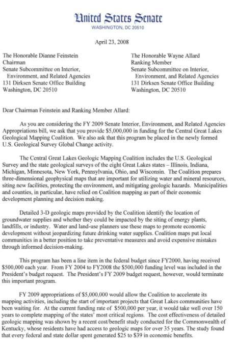
20 Congressional Congressional Interactions Interactions/Support Great Lakes Geologic Mapping Coalition


21 Summary of Activities 655 Congressional Visits ~30 District office visits Appropriations Request Letters 2001 Delegation Letter 2003 Multi-state Delegation Letter 2001 and 2003 Dear Conferee Letters 2004 Request Letters 2005 Multi-state Delegation Letter 2006 Multi-state Delegation Letter 2007 Multi-state Delegation Letters 2008 Multi-state Delegation letters 2009 Multi-state Delegation Letter and Great Lakes Task Force Letter 2010 Great Lakes Task Force Letters 2011 Personal Program Requests

22 8:30 OH Gillmor-Andrew Beck, 1203 LHOB 11:30 OH/MI DeWine/Levin-Joy 8:45 IL Durbin-Catherine Potter, Coalition Meeting Schedule SD IN Lugar-Aaron Whitesel, SH- 306 IN Hill-Lisa Shelton, 1024 LHOB v. int. IL Gutierrez-Tom Kotarac, 2367 RHOB IL Hastert-Anthony Reed, 235 CHOB 9:15 MI Smith-Brian Bowker, 2305 RHOB 9:30 OH Boehner-Gary Mahmoud, 1011 LHOB IL Weller-Torrey Babson, 1210 LHOB 9:45 OH Tiberi-Bruce Cuthbertson, 113 CHOB IN Souder-Mark Pfundstein, 1227 LHOB 10 OH Voinovich-Brian Mormino, SH-317 IL Fitzgerald-Bridget McNally, SD-555 MI Upton-Chuck Yessaian, 2161 RHOB IL Rush-Yardly Pollas, 2416 RHOB IL Shimkus-Ray Fitzgerald, 513 CHOB 10:15 IL Johnson-Therese Rios, 1229 LHOB IN Pence-Leanne Holdman, 1605 LHOB 10:30 MI Stabenow-Kristen Knepper, SH-702 OH Turner-Mike Wiehe, 1740 LHOB MI Ehlers-Ellen Burns, 1714 LHOB OH Strickland-Michelle Dallafior, 336 CHOB 10:45 IL Schakowski, Amy Fuller, 515 CHOB 11 IL Kirk-Cholly Smith, 1531 LHOB MI Levin-Dan Jourdan, 2300 RHOB v. int. IL Manzullo-Steve Johnson, 2228 RHOB 11:15 IL Governor s Office-Sol Ross, 440 N. Capitol St., Suite 240 OH Jones-Tannaz Haddadi, 1009 LHOB MI Kilpatrick-Jake Bennett, 1610 LHOB OH Pryce-Peter Freeman, 221 CHOB IN Hostettler-Adam Howard, 1214 LHOB


23 Multi-State DC Hill Visits
24
25 Personal letter to a constituent


26

27


28


29 Current GLGMC 3D Mapping and Modeling Program Lake County, Illinois Illinois GLGMC Priority Mapping Areas

30 ISGS Visualization Laboratory

31 Historical Aerial Photography

32 Fit Soil C-Horizons to Photography

33 Fit Quaternary Geology to Photography

34 Add Subsurface Well Data


35 Classify Well Data According to Materials and Stratigraphy

36 Integrate Well Data with Downhole Geophysical Profiles

37 Integrate Seismic Profiles with Water Well Data and 3D Geologic Model Tunnel valley Contributed by A. Pugin

38 Create Layered Surfaces Using Cross-sections as Guides

39 Create Layered Surfaces of Quaternary Sediments and eventually a Solids Model

40 Solids & Pullapart Model
41 Coalition Priority Mapping Area: Middle Illinois River Valley Scientific Discoveries: Sediments are not as old as we thought. Ancient Mississippi River migrated over a 15-mile wide channel, and seemed to be located first on the eastern side of the bedrock valley and then migrated westward. Residence time of Illinois Episode glacial ice in region was just over the last 20,000 years of the 55,000-year period. Mississippi River diverted 24.8 ka. There is a deep and very thick sand and gravel aquifer underlying a large portion of the region east of the present day valley.
 2980 ft of core 25 OSL ages (UNL) 20 from 6 cores 5 from 5")
 7 from 2 cores 13 from 4 outcrops Clear Creek Section 96.1 6.")
42 Sampling and Age Determinations 16 continuous cores 52 to 330 ft deep (eight >200 ft) 2980 ft of core 25 OSL ages (UNL) 20 from 6 cores 5 from 5 outcrops (7 more are planned) C ages (conventional and AMS; ISGS and other labs) 7 from 2 cores 13 from 4 outcrops Clear Creek Section ka 42


43 Borehole and Outcrop Locations Condit # 1 Nauman # 1 Fidler # 1 Miller # 1 Schoepke # 1 Taylor # 1 Condit # 3 Rattlesnake Hollow Ground surface Bedrock surface 43


44 Sediment ages younger than expected - Correlations West * Recent results East 129ka* *36.5 ka 168 ka* 130ka* ~144 ka *100 ka *141 ka ka ~160 ka 25 ka ~155 ka 44
45 Illinois Episode ( YBP) ice was in central IL longer (~20 kyr) than Wisconsin Episode (75-12YBP) ice (~14 kyr). Glaciers in IL near end of Illinois & Wisconsin Episodes


46 Thick sand & gravel aquifer underlies uplands July Fidler Core East of Henry

47 Bedrock Topography


48 Elevation of the Top of the Big Sand Big Sand Thickness

49 Surficial Geology

50 Great Lakes Geologic Mapping Coalition Rivers Initiative

51 Derivative Maps and Applications From 1999 Coalition 3D Geologic Mapping Implementation Plan NOTE >15 of 46 map applications directly related to rivers and surface water.

52 Maps Required for User Applications NOTE 4 of 17 maps required for user application directly related to rivers and surface water.

53 Red R. Input from map users helped determine priorities Grand R.

54 ISGS Status of Geologic Mapping Illinois River only partially completed Illinois GLGMC Priority Mapping Areas
55 Thoughts on Adding a GLGMC River Component Indiana - I like the idea for several reasons. Its important for the Coalition to grow scientifically. This represents a very important research direction so why not grow in this direction. Societal applications are huge. Theoretical linkages between glacial geology and fluvial geology are also huge. It would stimulate thinking within our close-knit group. It should help the Coalition politically because we collectively can't help but be involved in a wider crosssection of environmental issues. It should help us logistically because it represents more collective resources. The current Coalition is mature enough to handle such an expansion. Lastly, it represents, potentially, a way to grow the funding and we're desperate for this. Ohio - I think having a group to promote the geology of rivers (and /or lakes) would be a great idea given how so much of the science is now emphasizing biology/biodiversity/habitat, etc. Granted, these are all important-however, the framework geology and its relative importance are at some point going to be lost on future generations. New York -This theme of Big rivers works here in NY as well, the Mohawk, Hudson and Susquehanna are all big players. Right now I do not have a dog in this fight but most of our projects have some external connection. Typical inputs for our STATEMAP proposals are Landslides, in Lake Clays, flood hazards etc. Wisconsin - Being the person in the Coalition who s probably most directly tied to working with river systems, I m all in favor of the idea. I m a big advocate of the glacial and pro-glacial (and periglacial) aspect of the Coalition s charter, and the work that I do with Coalition funds reflects that. I m coming more and more to believe that pro-glacial systems will be the emerging field for providing an absolute chronology of glacial events in the Midwest, and I think it would be great to have people involved in fluvial research have a venue for seeing how their research overlaps with the Coalition work.


56 Past Yields Clues to the Present Present is the Key to the Past GLGMC can help with: In Illinois - understanding of the AMR For everyone - lots of infrastructure GLGMC needs help with: Sedimentological aspects of river deposits Old vs. new Visible vs. buried Identification of bed forms Occurrence and age of wetlands Fluvial hydraulics Meander formation River changes associated with erosion and deposition Currents, flows, and flooding What else? DISCUSSION
Geological Mapping What It Is, Who Does It, and Why We Do It
 Geological Mapping What It Is, Who Does It, and Why We Do It Richard C. Berg Director, Illinois State Geological Survey Geologic mapping portrays the distribution, composition, and structure of geologic
Surficial Geologic Mapping Proposal for STATEMAP FY2019
 Surficial Geologic Mapping Proposal for STATEMAP FY2019 presented by David Grimley Illinois State Geological Survey Prairie Research Institute, University of Illinois IGMAC meeting, September 6 th, 2018
IGMAC 2015: Surficial Geologic Mapping STATEMAP past and future. Valparaiso Moraine, Will County
 IGMAC 2015: Surficial Geologic Mapping STATEMAP past and future Valparaiso Moraine, Will County presented by Drew Phillips, September 10. 2015 SURFICIAL MAPPING Completed Aug 2015 NE Illinois Project:
Pat Dryer Half Moon Lake: A True Oxbow Lake? Geography 364 April 1 st, 2007
 Pat Dryer Half Moon Lake: A True Oxbow Lake? Geography 364 April 1 st, 2007 Appendix Abstract 2 Introduction 3 Methods 3 Results 3 Discussion 5 Conclusion 11 1 Abstract Half Moon Lake appears to be an
Surficial Geology of Antioch Quadrangle
 Illinois Preliminary Geologic Map IPGM Antioch-SG Surficial Geology of Antioch Quadrangle Lake County, Illinois and Kenosha County, Wisconsin Andrew J. Stumpf and Michael L. Barnhardt 2005 Department of
A method for three-dimensional mapping, merging geologic interpretation, and GIS computation
 A method for three-dimensional mapping, merging geologic interpretation, and GIS computation Soller, David R., U.S. Geological Survey, 908 National Center, Reston, VA 20192 and Richard C. Berg, Illinois
Which landscape best represents the shape of the valleys occupied by glaciers? A) B) C) D)
 B) C) D)") 1. Glaciers often form parallel scratches and grooves in bedrock because glaciers A) deposit sediment in unsorted piles B) deposit rounded sand in V-shaped valleys C) continually melt and refreeze D) drag
1. Glaciers often form parallel scratches and grooves in bedrock because glaciers A) deposit sediment in unsorted piles B) deposit rounded sand in V-shaped valleys C) continually melt and refreeze D) drag
Basin Analysis Applied to Modelling Buried Valleys in the Great Lakes Basin
 EARTH SCIENCES SECTOR GENERAL INFORMATION PRODUCT 35 Basin Analysis Applied to Modelling Buried Valleys in the Great Lakes Basin Sharpe, D R; Russell, H A J 2004 Originally released as: Basin Analysis
W he natural resources of Adams
 Above: Houghton Rock, Town of Adams. Following Page: "The Hole in the Rock" on Rattlesnake Mound--both remnants of rock formed by ancient seas hundreds of millions of year5 ago. (Courtesy, H.H. Bennett
Why is Sebago Lake so deep?
 Maine Geologic Facts and Localities February, 1999 Why is Sebago Lake so deep? 43 51 13.36 N, 70 33 43.98 W Text by Robert A. Johnston, Department of Agriculture, Conservation & Forestry 1 Introduction
Buried-valley Aquifers: Delineation and Characterization from Reflection Seismic and Core Data at Caledon East, Ontario
 Buried-valley Aquifers: Delineation and Characterization from Reflection Seismic and Core Data at Caledon East, Ontario Russell, H.A.J. 1, S.E. Pullan 1, J.A. Hunter 1, D.R. Sharpe 1, and S. Holysh 2 1
The Geology of Sebago Lake State Park
 Maine Geologic Facts and Localities September, 2002 43 55 17.46 N, 70 34 13.07 W Text by Robert Johnston, Department of Agriculture, Conservation & Forestry 1 Map by Robert Johnston Introduction Sebago
Geologic Mapping in Northeastern Illinois. What do we know about. Donald A. Keefer, Director Geologic Mapping and Hydrogeology Center
 Geologic Mapping in Northeastern Illinois & What do we know about Lake County s Geology? Donald A. Keefer, Director Geologic Mapping and Hydrogeology Center Societal Benefits of Mapping Water Supply Delineation,
Michigan s Geology and Groundwater
 Michigan s Geology and Groundwater Ralph J. Haefner Deputy Director U.S. Geological Survey Michigan-Ohio Water Science Center Lansing, Michigan Outline About the USGS Geology 101 Michigan s geology Bedrock
PALEOGEOGRAPHY of NYS. Definitions GEOLOGIC PROCESSES. Faulting. Folding 9/6/2012. TOPOGRAPHIC RELIEF MAP of NYS GRADATIONAL TECTONIC
 TOPOGRAPHIC RELIEF MAP of NYS PALEOGEOGRAPHY of NYS Prof. Anthony Grande AFG 2012 Definitions GEOLOGIC PROCESSES Geography: study of people living on the surface of the earth. Geology: the scientific study
Geology and New England Landscapes
 Geology and New England Landscapes Jim Turenne, CPSS USDA-NRCS Warwick, RI. http://nesoil.com Why Geology? Provides the big picture of site conditions. Major part of soil formation (parent material and
Geological Mapping using Geophysics
 Geological Mapping using Geophysics Pugin, A.J.M. and T.H. Larson Illinois State Geological Survey, 615 E Peabody Dr., Champaign, IL 61820; E-mail: A.J.M. Pugin at pugin@isgs.uiuc.edu Mapping Techniques.
4. The map below shows a meandering stream. Points A, B, C, and D represent locations along the stream bottom.
 1. Sediment is deposited as a river enters a lake because the A) velocity of the river decreases B) force of gravity decreases C) volume of water increases D) slope of the river increases 2. Which diagram
 Page 1 of 9 Name: Base your answer to the question on the diagram below. The arrows show the direction in which sediment is being transported along the shoreline. A barrier beach has formed, creating a
Chapter 2. Wearing Down Landforms: Rivers and Ice. Physical Weathering
 Chapter 2 Wearing Down Landforms: Rivers and Ice Physical Weathering Weathering vs. Erosion Weathering is the breakdown of rock and minerals. Erosion is a two fold process that starts with 1) breakdown
Lab Final Review 4/16/18
 Lab Final Review 4/16/18 Overall goals from lab Think about geology on recent timescales, predict the direction change Be able to identify how different landforms or patterns (e.g. drainage patterns, dune
Terrain Units PALEOGEOGRAPHY: LANDFORM CREATION. Present Geology of NYS. Detailed Geologic Map of NYS
 NYS TOPOGRAPHY Why so? PALEOGEOGRAPHY: LANDFORM CREATION Prof. Anthony Grande AFG 014 Present Geology of NYS Detailed Geologic Map of NYS Generalized Geology Detailed Geology Hot links to the fold out
Surficial Geology of Oak Hill Quadrangle
 Illinois Preliminary Geologic Map IPGM Oak Hill-SG Surficial Geology of Oak Hill Quadrangle Peoria County, Illinois François Hardy and C. Pius Weibel 2008 ILLINOIS STATE GEOLOGICAL SURVEY E. Donald McKay
Waterbury Dam Disturbance Mike Fitzgerald Devin Rowland
 Waterbury Dam Disturbance Mike Fitzgerald Devin Rowland Abstract The Waterbury Dam was completed in October 1938 as a method of flood control in the Winooski Valley. The construction began in April1935
mountain rivers fixed channel boundaries (bedrock banks and bed) high transport capacity low storage input output
 high transport capacity low storage input output") mountain rivers fixed channel boundaries (bedrock banks and bed) high transport capacity low storage input output strong interaction between streams & hillslopes Sediment Budgets for Mountain Rivers Little
mountain rivers fixed channel boundaries (bedrock banks and bed) high transport capacity low storage input output strong interaction between streams & hillslopes Sediment Budgets for Mountain Rivers Little
T. Perron Glaciers 1. Glaciers
 T. Perron 12.001 Glaciers 1 Glaciers I. Why study glaciers? [PPT: Perito Moreno glacier, Argentina] Role in freshwater budget o Fraction of earth s water that is fresh (non-saline): 3% o Fraction of earth
Page 1. Name:
 Name: 1) Which property would best distinguish sediment deposited by a river from sediment deposited by a glacier? thickness of sediment layers age of fossils found in the sediment mineral composition
Name: Which rock layers appear to be most resistant to weathering? A) A, C, and E B) B and D
 A, C, and E B) B and D") Name: 1) The formation of soil is primarily the result of A) stream deposition and runoff B) precipitation and wind erosion C) stream erosion and mass movement D) weathering and biological activity 2)
Name: 1) The formation of soil is primarily the result of A) stream deposition and runoff B) precipitation and wind erosion C) stream erosion and mass movement D) weathering and biological activity 2)
Moosehead Lake and the Tale of Two Rivers
 Maine Geologic Facts and Localities June, 2005 45 o 53 5.09 N, 69 o 42 14.54 W Text by Kelley, A.R.; Kelley, J.T.; Belknap, D.F.; and Gontz, A.M. Department of Earth Sciences, University of Maine, Orono,
RIVERS, GROUNDWATER, AND GLACIERS
 RIVERS, GROUNDWATER, AND GLACIERS Delta A fan-shaped deposit that forms when a river flows into a quiet or large body of water, such as a lake, an ocean, or an inland sea. Alluvial Fan A sloping triangle
Surficial Geology of Dunlap Quadrangle
 Illinois Preliminary Geologic Map IPGM Dunlap-SG Surficial Geology of Dunlap Quadrangle Peoria County, Illinois François Hardy and C. Pius Weibel 2008 ILLINOIS STATE GEOLOGICAL SURVEY E. Donald McKay III,
Annotated Bibliography of River Avulsions Pat Dryer Geography 364 5/14/2007
 Annotated Bibliography of River Avulsions Pat Dryer Geography 364 5/14/2007 1 Table of Contents Introduction 2 Annotations I. River avulsions and their deposits 2 II. Channel avulsion on alluvial fans
Page 1. Name:
 Name: 1) Which event is the best example of erosion? dissolving of rock particles on a limestone gravestone by acid rain breaking apart of shale as a result of water freezing in a crack rolling of a pebble
THE OHIO JOURNAL OF SCIENCE
 THE OHIO JOURNAL OF SCIENCE VOL. LIII MARCH, 1953 No. 2 SUBSURFACE STUDY OF GLACIAL DEPOSITS AT CLEVELAND, OHIO C. T. BAGLEY Sverdrup & Parcel, Inc., Consulting Engineers, St. Lotus, Mo. The soil 1 strata
Name: Mid-Year Review #2 SAR
 Name: Mid-Year Review #2 SAR Base your answers to questions 1 through 3 on on the diagram below, which shows laboratory materials used for an investigation of the effects of sediment size on permeability,
GEOL.3250 Geology for Engineers Glacial Geology
 GEOL.3250 Geology for Engineers Glacial Geology NAME Part I: Continental Glaciation Continental glaciers are large ice sheets that cover substantial portions of the land area. In the region of accumulation
Lecture 10 Glaciers and glaciation
 Lecture 10 Glaciers and glaciation Outline Importance of ice to people! Basics of glaciers formation, classification, mechanisms of movement Glacial landscapes erosion and deposition by glaciers and the
General Geologic Setting and Seismicity of the FHWA Project Site in the New Madrid Seismic Zone
 General Geologic Setting and Seismicity of the FHWA Project Site in the New Madrid Seismic Zone David Hoffman University of Missouri Rolla Natural Hazards Mitigation Institute Civil, Architectural & Environmental
Training the Next Generation of Geoscientists to Solve Realworld Environmental Problems using Advanced Techniques: Year Two Report
 Illinois State Geological Survey 615 E. Peabody Dr. Champaign, IL 61820 Training the Next Generation of Geoscientists to Solve Realworld Environmental Problems using Advanced Techniques: Year Two Report
Seismic Reflection Imaging across the Johnson Ranch, Valley County, Idaho
 Seismic Reflection Imaging across the Johnson Ranch, Valley County, Idaho Report Prepared for the Skyline Corporation Lee M. Liberty Center for Geophysical Investigation of the Shallow Subsurface (CGISS)
THE BEDROCK SURFACE AND FORMER DRAINAGE SYSTEMS OF MONTGOMERY COUNTY, OHIO 1
 THE BEDROCK SURFACE AND FORMER DRAINAGE SYSTEMS OF MONTGOMERY COUNTY, OHIO 1 STANLEY E. NORRIS, Geologist, U. S. Geological Survey, Columbus, Ohio INTRODUCTION The bedrock surface of Montgomery County,
*Anne Carter Witt Matt Heller
 *Anne Carter Witt Matt Heller Division of Geology and Mineral Resources, Virginia Department of Mines, Minerals and Energy, 900 Natural Resources Drive, Suite 500, Charlottesville, VA 22903 anne.witt@dmme.virginia.gov
27. Running Water I (p ; )
") 27. Running Water I (p. 424-436; 440-444) Hydrosphere How much of the Earth s surface is covered by water? Earth's water is collectively called the and is stored in a number of so-called as follows: 1.
27. Running Water I (p. 424-436; 440-444) Hydrosphere How much of the Earth s surface is covered by water? Earth's water is collectively called the and is stored in a number of so-called as follows: 1.
Project Area. Funded by the Illinois Department of Transportation Springfield, Illinois
 Three-dimensional Geologic Mapping for Transportation Planning in Central-northern northern Illinois: Data Selection, Map Construction, and Model Development Richard C. Berg, E. Donald McKay, Donald A.
KANSAS GEOLOGICAL SURVEY Open File Report LAND SUBSIDENCE KIOWA COUNTY, KANSAS. May 2, 2007
 KANSAS GEOLOGICAL SURVEY Open File Report 2007-22 LAND SUBSIDENCE KIOWA COUNTY, KANSAS Prepared by Michael T. Dealy L.G., Manager, Wichita Operations SITE LOCATION The site was approximately four miles
STUDY GUIDE FOR CONTENT MASTERY. Surface Water Movement
 Surface Water SECTION 9.1 Surface Water Movement In your textbook, read about surface water and the way in which it moves sediment. Complete each statement. 1. An excessive amount of water flowing downslope
Evidence for distribution and thickness of Athens Sub-episode and older sediments in Ottawa County, Michigan
 Evidence for distribution and thickness of Athens Sub-episode and older sediments in Ottawa County, Michigan Patrick M. Colgan Department of Geology Grand Valley State University With thanks to Al Kehew
QUATERNARY AND GLACIAL GEOLOGY
 QUATERNARY AND GLACIAL GEOLOGY JURGEN EHLERS Geologisches Landesamt, Germany Translated from Allgemeine und historische Quartdrgeologie English version by Philip L. Gibbard JOHN WILEY & SONS Chichester
Cattaraugus Creek: A Story of Flowing Water and the Geology of the Channel It Flows Through Presentation to West Valley Citizen Task Force 4/27/16
 Cattaraugus Creek: A Story of Flowing Water and the Geology of the Channel It Flows Through Presentation to West Valley Citizen Task Force 4/27/16 Raymond C. Vaughan, Ph.D. What happens if you drop a
Surface Water Short Study Guide
 Name: Class: Date: Surface Water Short Study Guide Multiple Choice Identify the letter of the choice that best completes the statement or answers the question. 1. The three ways in which a stream carries
Chapter 2. Denudation: Rivers and Ice
 Chapter 2. Denudation: Rivers and Ice DENUDATION: process that lowers level of land - caused by rivers, glaciers, waves & wind - involves processes of WEATHERING & EROSION Weathering Def: breakdown of
THE QUATERNARY GEOLOGY OF NEWARK BAY AND KILL VAN KULL CHANNEL, NEW YORK AND NEW JERSEY. and
 THE QUATERNARY GEOLOGY OF NEWARK BAY AND KILL VAN KULL CHANNEL, NEW YORK AND NEW JERSEY Stephanie Beda, W. Bruce Ward, William Murphy, Robert Fleming, Gary Fleming, Beckett Boyd Earthworks LLC 27 Glen
Geomorphology for Engineers
 Geomorphology for Engineers Edited by P. G. Fookes, E. M. Lee and G. Milligan Whittles Publishing CRC PRESS Contents Foreword Preface Dedication Biographies 1. Introduction to Engineering Geomorphology
CURRICULUM TR AILING ICE AGE M YST ERI E S
 MIDDLE SCHOOL CURRICULUM TR AILING ICE AGE M YST ERI E S THE Driftless Area CONTENTS I. Enduring Knowledge... 3 II. Teacher Background... 3 III. Before Viewing the Video... 5 IV. Viewing Guide... 5 V.
Harvey Thorleifson, Director, Minnesota Geological Survey. Status of geological mapping needed for groundwater protection in Minnesota
 Harvey Thorleifson, Director, Minnesota Geological Survey Status of geological mapping needed for groundwater protection in Minnesota Minnesota is located between the Dakotas and Wisconsin, north of Iowa,
The boulder was most likely moved to this location by A) glacial ice B) prevailing wind C) streamfiow D) volcanic action
 glacial ice B) prevailing wind C) streamfiow D) volcanic action") 1. Which rock material was most likely transported to its present location by a glacier? A) rounded sand grains found in a river delta B) rounded grains found in a sand dune C) residual soil found on a
1. Which rock material was most likely transported to its present location by a glacier? A) rounded sand grains found in a river delta B) rounded grains found in a sand dune C) residual soil found on a
Maggie Payne Jim Turenne
 Maggie Payne Jim Turenne USDA-NRCS 60 Quaker Lane, Suite 46 Warwick, RI. 02886 401-822-8832 maggie.payne@ri.usda.gov U.S. Department of Agriculture 1935: Soil Conservation Service (SCS) Natural Resources
Integrating 3-D Facies Analysis of Glacial Aquifer Systems with Groundwater Flow Models: Examples from New England and the Great Lakes Region, USA
 Integrating 3-D Facies Analysis of Glacial Aquifer Systems with Groundwater Flow Models: Examples from New England and the Great Lakes Region, USA Stone, B.D., J.R. Stone, J.P. Masterson, and D.W. O'Leary
Science and Health EFFECT OF EROSION ON THE CONDITION OF SOIL AND LAND SHAPE
 4 Module 51 Science and Health EFFECT OF EROSION ON THE CONDITION OF SOIL AND LAND SHAPE A DepEd-BEAM Distance Learning Program supported by the Australian Agency for International Development To the Learner
Name. 4. The diagram below shows a soil profile formed in an area of granite bedrock. Four different soil horizons, A, B, C, and D, are shown.
 Name 1. In the cross section of the hill shown below, which rock units are probably most resistant to weathering? 4. The diagram below shows a soil profile formed in an area of granite bedrock. Four different
Question #1: What are some ways that you think the climate may have changed in the area where you live over the past million years?
 Reading 5.2 Environmental Change Think about the area where you live. You may see changes in the landscape in that area over a year. Some of those changes are weather related. Others are due to how the
Glacial Deposition and Groundwater in Dutchess County
 Glacial Deposition and Groundwater in Dutchess County Name: Period: Thousands of years ago an enormous ice sheet blanketed the Hudson Valley in what was called the Wisconsinan Glaciation. The ice reshaped
How Do Human Impacts and Geomorphological Responses Vary with Spatial Scale in the Streams and Rivers of the Illinois Basin?
 How Do Human Impacts and Geomorphological Responses Vary with Spatial Scale in the Streams and Rivers of the Illinois Basin? Bruce Rhoads Department of Geography University of Illinois at Urbana-Champaign
BLAKENEY ESKER AND HOW IT FORMED. The Blakeney Esker is a ridge, around 3.5 km in length, which runs southeastwards
 BLAKENEY ESKER AND HOW IT FORMED Introduction The Blakeney Esker is a ridge, around 3.5 km in length, which runs southeastwards from west of Blakeney, to Wiveton Downs, north-west of Glandford, in north
Surficial Geology of Henry County, Illinois
 Illinois County Geologic Map ICGM Henry-SG Surficial Geology of Henry County, Illinois Richard C. Anderson and Xiaodong Miao 2011 Prairie Research Institute ILLINOIS STATE GEOLOGICAL SURVEY 615 East Peabody
The Driftless Area. Dave Speer Geography 326
 The Driftless Area Dave Speer Geography 326 Introduction: Wisconsin s landscape is defined by many physical features resulting from continental glaciation. Wisconsin is unique in the fact that it possesses
Holocene Meander Incision Imposed Across a Buried Valley Wall
 Holocene Meander Incision Imposed Across a Buried Valley Wall Michael P. Wilson Geosciences Department SUNY College at Fredonia Fredonia, NY 14063 (716/673-3843) and William T. Boria Division of Environmental
FORENSIC GEOLOGY A CIVIL ACTION
 NAME 89.215 - FORENSIC GEOLOGY A CIVIL ACTION I. Introduction In 1982 a lawsuit was filed on behalf of eight Woburn families by Jan Schlictmann. The suit alleged that serious health effects (childhood
patersongroup Consulting Engineers April 20, 2010 File: PG1887-LET.01R Novatech Engineering Consultants Suite 200, 240 Michael Cowpland Drive
 patersongroup April 20, 2010 File: PG1887-LET.01R Novatech Engineering Consultants Suite 200, 240 Michael Cowpland Drive Ottawa, Ontario K2M 1P6 Attention: Mr. Adam Thompson Consulting Engineers 28 Concourse
Lower Mainland Surficial Geology From Wisconsin Ice Age to Protocol 21
 Lower Mainland Surficial Geology From Wisconsin Ice Age to Protocol 21 BCEIA BEST Conference 2018 Whistler, BC Kalina Malowany and Virginie Brunetaud Presentation Outline 1. Surficial Geology it s more
Module/Unit: Landforms Grade Level: Fifth
 Module/Unit: Landforms Grade Level: Fifth PA Academic Standards for Science and Technology and Environment and Ecology: 3.1.7.B Describe the use of models as an application or scientific or technological
Name Roy G Biv Page 1
 Name Roy G Biv Base your answers to questions 1 through 3 on the diagram below. The arrows show the direction in which sediment is being transported along the shoreline. A barrier beach has formed, creating
Weathering, Erosion, Deposition, and Landscape Development
 Weathering, Erosion, Deposition, and Landscape Development I. Weathering - the breakdown of rocks into smaller particles, also called sediments, by natural processes. Weathering is further divided into
SURFACE GEOLOGY AND LIQUEFACTION SUSCEPTIBILITY IN THE INNER RIO GRANDE VALLEY NEAR ALBUQUERQUE, NEW MEXICO
 SURFACE GEOLOGY AND LIQUEFACTION SUSCEPTIBILITY IN THE INNER RIO GRANDE VALLEY NEAR ALBUQUERQUE, NEW MEXICO Keith I. Kelson, Christopher S. Hitchcock, and Carolyn E. Randolph William Lettis & Associates,
INVESTIGATING AND UNDERSTANDING THE GROUND WHY BOTHER?
 INVESTIGATING AND UNDERSTANDING THE GROUND WHY BOTHER? Dr Jacqueline Skipper Geotechnical Consulting Group WHAT IS UNDERSTANDING THE GROUND? Site Good enough ground model for successful project construction
FUTURE MEANDER BEND MIGRATION AND FLOODPLAIN DEVELOPMENT PATTERNS NEAR RIVER MILES 241 TO 235, SACRAMENTO RIVER
 FUTURE MEANDER BEND MIGRATION AND FLOODPLAIN DEVELOPMENT PATTERNS NEAR RIVER MILES 241 TO 235, SACRAMENTO RIVER Eric W. Larsen University of California, Davis With the assistance of Evan Girvetz REPORT
Pre-Lab Reading Questions ES202
 ES202 The are designed to encourage students to read lab material prior to attending class during any given week. Reading the weekly lab prior to attending class will result in better grade performance
NDWRCDP Disclaimer This work was supported by the National Decentralized Water Resources Capacity Development Project (NDWRCDP) with funding provided
 with funding provided") Glacial Landforms NDWRCDP Disclaimer This work was supported by the National Decentralized Water Resources Capacity Development Project (NDWRCDP) with funding provided by the U.S. Environmental Protection
Glacial Landforms NDWRCDP Disclaimer This work was supported by the National Decentralized Water Resources Capacity Development Project (NDWRCDP) with funding provided by the U.S. Environmental Protection
Jim Turenne. Soils on Social Media
 Jim Turenne USDA-NRCS 60 Quaker Lane, Suite 46 Warwick, RI. 02886 401-822-8832 Jim.turenne@ri.usda.gov Soils on Social Media www.twitter.com/soilsne www.fb.com/soilsne www.nesoil.com U.S. Department of
Landscape. Review Note Cards
 Landscape Review Note Cards Last Ice Age Pleistocene Epoch that occurred about 22,000 Years ago Glacier A large, long lasting mass of ice which forms on land and moves downhill because of gravity. Continental
EROSION AND DEPOSITION
 CHAPTER 8 EROSION AND DEPOSITION SECTION 8 1 Changing Earth s Surface (pages 252-255) This section explains how sediment is carried away and deposited elsewhere to wear down and build up Earth s surface.
- Cased-hole geophysical well logs - Airborne geophysics - Seismic data - LiDAR. GeoConvention 2015: New Horizons 1
 Thermal Effects and Quaternary Hydrogeology: Making Good Decisions in a Complex Geologic Setting Timothy Johnsen, Phd, Quaternary Specialist (tjohnsen@matrix-solutions.com) Alex Haluszka, MSc, P.Geol.,
Holocene Lower Mississippi River Avulsions: Autogenic Versus Allogenic Forcing*
 Holocene Lower Mississippi River Avulsions: Autogenic Versus Allogenic Forcing* Eric Prokocki 1,2 Search and Discovery Article #50330 (2010) Posted October 14, 2010 *Adapted from oral presentation at AAPG
Topic 6: Weathering, Erosion and Erosional-Deposition Systems (workbook p ) Workbook Chapter 4, 5 WEATHERING
 Workbook Chapter 4, 5 WEATHERING") Topic 6: Weathering, Erosion and Erosional-Deposition Systems (workbook p. 95-125) Workbook Chapter 4, 5 THE BIG PICTURE: Weathering, erosion and deposition are processes that cause changes to rock material
Topic 6: Weathering, Erosion and Erosional-Deposition Systems (workbook p. 95-125) Workbook Chapter 4, 5 THE BIG PICTURE: Weathering, erosion and deposition are processes that cause changes to rock material
Geotechnical Aspects of the Ohio River Bridges Project
 Geotechnical Aspects of the Ohio River Bridges Project Mark A. Litkenhus, PE Sr. Geotechnical Engineer Stephen H. Bickel, PE Sr. Geotechnical Engineer STGEC Ohio River Bridges at Louisville Geotechnical
11/22/2010. Groundwater in Unconsolidated Deposits. Alluvial (fluvial) deposits. - consist of gravel, sand, silt and clay
 deposits. - consist of gravel, sand, silt and clay") Groundwater in Unconsolidated Deposits Alluvial (fluvial) deposits - consist of gravel, sand, silt and clay - laid down by physical processes in rivers and flood plains - major sources for water supplies
Groundwater in Unconsolidated Deposits Alluvial (fluvial) deposits - consist of gravel, sand, silt and clay - laid down by physical processes in rivers and flood plains - major sources for water supplies
Weathering, Erosion, Deposition
 Weathering, Erosion, Deposition The breakdown of rocks at or near the Earth s Surface. Physical Chemical - The breakdown of rock into smaller pieces without chemical change. - Dominant in moist /cold conditions
Unit 3 Review - Surface Processes
 Unit 3 Review - Surface Processes 1. Why is the surface of Mercury covered with meteor impact craters, while Earth s surface has relatively few craters? A) Mercury is larger than Earth, so it gets hit
Earth processes are dynamic actions that occur both on
 29 Weathering, Erosion, and Deposition R EA D I N G Earth processes are dynamic actions that occur both on the earth s surface and inside the earth. Any process that breaks down earth material, such as
Soils, Hydrogeology, and Aquifer Properties. Philip B. Bedient 2006 Rice University
 Soils, Hydrogeology, and Aquifer Properties Philip B. Bedient 2006 Rice University Charbeneau, 2000. Basin Hydrologic Cycle Global Water Supply Distribution 3% of earth s water is fresh - 97% oceans 1%
Lecture Outline Lecture Outline Monday April 9-16, 2018 Questions? Announcements:
 Lecture Outline Lecture Outline Monday April 9-16, 2018 Questions? Announcements: Geology 101 Night Video: The Day After Tomorrow Hollywood disaster movie about the onset of a glacial period When: Monday
MAPPING BEDROCK: Verifying Depth to Bedrock in Calumet County using Seismic Refraction
 MAPPING BEDROCK: Verifying Depth to Bedrock in Calumet County using Seismic Refraction Revised December 13, 2011 Dave Hart Wisconsin Geological and Natural History Survey INTRODUCTION Seismic refraction
1. Any process that causes rock to crack or break into pieces is called physical weathering. Initial product = final product
 Weathering 1. Any process that causes rock to crack or break into pieces is called physical weathering. Initial product = final product End Result of physical weathering is increased surface area. 2. Physical
CAUSES FOR CHANGE IN STREAM-CHANNEL MORPHOLOGY
 CAUSES FOR CHANGE IN STREAM-CHANNEL MORPHOLOGY Chad A. Whaley, Department of Earth Sciences, University of South Alabama, MobileAL, 36688. E-MAIL: caw408@jaguar1.usouthal.edu The ultimate goal of this
APPENDIX G GLOSSARY. Mn/DOT/WR-0200
 APPENDIX G GLOSSARY Mn/DOT/WR-0200 Alluvial - comprised of clay, silt, sand, gravel, and/or other detritus deposited by water. Usually refers to accretionary overbank, floodplain or levee deposits. Biomantling
STREAM SYSTEMS and FLOODS
 STREAM SYSTEMS and FLOODS The Hydrologic Cycle Precipitation Evaporation Infiltration Runoff Transpiration Earth s Water and the Hydrologic Cycle The Hydrologic Cycle The Hydrologic Cycle Oceans not filling
Precipitation Evaporation Infiltration Earth s Water and the Hydrologic Cycle. Runoff Transpiration
 STREAM SYSTEMS and FLOODS The Hydrologic Cycle Precipitation Evaporation Infiltration Earth s Water and the Hydrologic Cycle Runoff Transpiration The Hydrologic Cycle The Hydrologic Cycle Oceans not filling
Final Exam. Running Water Erosion and Deposition. Willamette Discharge. Running Water
 Final Exam Running Water Erosion and Deposition Earth Science Chapter 5 Pages 120-135 Scheduled for 8 AM, March 21, 2006 Bring A scantron form A calculator Your 3 x 5 paper card of formulas Review questions
Chapter 2. Early Geologists Tackle History's Mysteries
 Chapter 2 Early Geologists Tackle History's Mysteries Nicolaus Steno and his Laws Danish (lived in Italy); 1638-1687 Pioneering studies of Italian strata Developed basic principles (laws) regarding age
Changes to Land 5.7B. landforms: features on the surface of Earth such as mountains, hills, dunes, oceans and rivers
 All the landforms on Earth have changed over time and continue to change. Many of the changes were caused by wind, moving water, and moving ice. Mountains have grown and shrunk. Rivers have cut away land