Recurrence of Kanto Earthquakes Revealed from Tsunami Deposits in Miura peninsula
|
|
|
- Brice Welch
- 5 years ago
- Views:
Transcription


1 Recurrence of Kanto Earthquakes Revealed from Tsunami Deposits in Miura peninsula Kunihiko Shimazaki 1,2, Kenji Satake 1*, Haeng Yoong Kim 1, Takeo Ishibe 1, Takashi Chiba 3 & Toshihiko Sugai 3 1 Earthquake Research Institute, University of Tokyo, Yayoi, Bunkyo ku, Tokyo , Japan; 2 Association for Earthquake Disaster Prevention, Shiba, Minatoku, Tokyo , Japan; 3 Graduate School of Frontier Sciences, University of Tokyo, Kashiwanoha, Kashiwa, Chiba, , Japan; *Author for correspondence, e mail: satake@eri.u tokyo.ac.jp

2 Plates around Japan Kanto Eq.


3 The 1923 Kanto earthquake Damage in Yokohama City Yokohama City Library Tsunami Damage in Ito City Ito City Office Total casualty ~ 100,000 (The worst earthquake disaster in Japan)
 Miyabe")
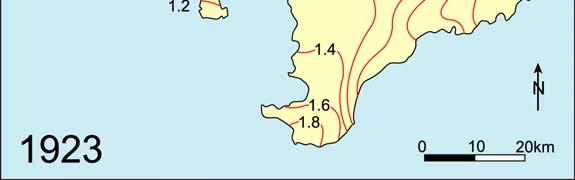
4 The 1923 (Taisho) Kanto earthquake Tsunami Heights Crustal deformation Hatori (1975) Miyabe (1931)

 Shishikura (2003) Larger")

5 The 1703 (Genroku) Kanto earthquake Previous earthquake at the plate boundary Tsunami Heights Crustal deformation Hatori (1975) Shishikura (2003) Larger tsunami on the Pacific coast of Boso peninsula Larger uplift on the southern tip of Boso Peninsula
6 Historical records of earthquakes Ueda and Usami (1990)

7 During Kamakura Era ( ), several damaging earthquakes were recorded, e.g., AD1257 M=7 7.5 AD1293 M~7 AD1433 M> 7 Historical records of earthquakes

8 modified from Shishikura, 2003 Geomorphological study


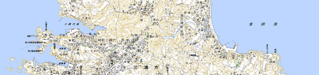
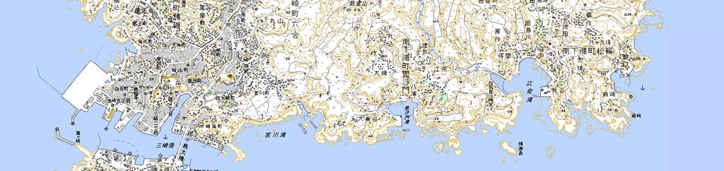
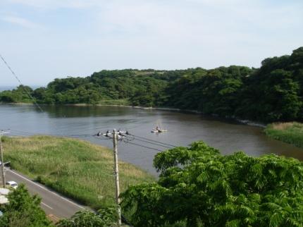
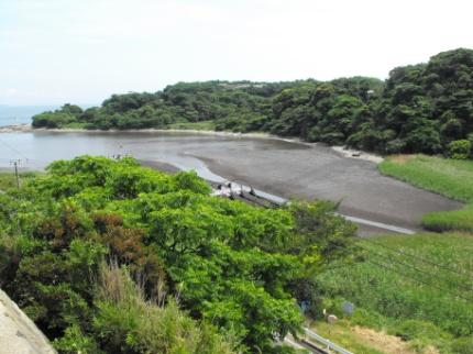
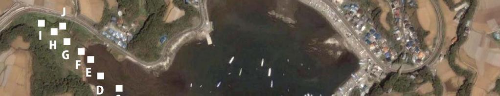
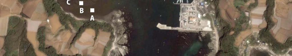
9 Miura Peninsula Koajiro Bay Aburatsubo Bay (tide gauge record since 1895) Ena Bay
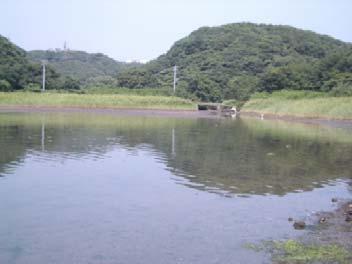
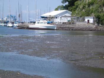
10 Study Site: Koaijiro Bay Koajiro Bay Tidal Flat Tide Gauge Station Aburatsubo Bay

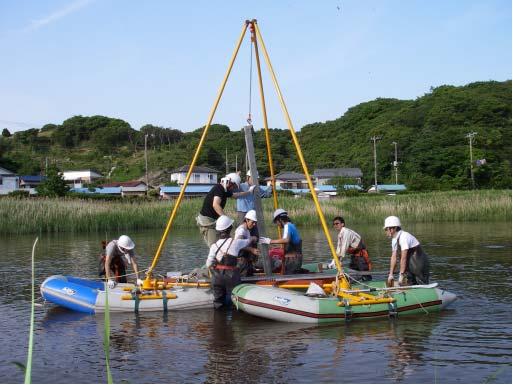
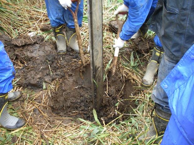
11 Array Coring using Geoslicer at Tidal Flat

12 Array Coring using Geoslicer at Tidal Flat

13 Sequence of Stratigraphy Seaward Landward Three event deposits in the bay sediment beneath tidal flat sediment


14 Tsunami Deposits T Kanto Eq. T Kanto Eq. T3 older Eq.

15 Grain Size Analysis Event Units composed of the coarse materials.
 subsidence and Sudden (coseismic)")
16 Fresh Water Species Diatom analysis Little diatom in event deposits, but increase after events Gradually increase of marine plankton Gradual (interseismic) subsidence and Sudden (coseismic) uplift


17 Study Site: Koaijiro Bay Tide Gauge Station Koajiro Bay Tidal Flat Aburatsubo Bay
18 Dating of most recent event (Cs, Pb) Cs-137 Cs 137 and Pb 210 indicate that T1 sand layer is brought by the 1923 Kanto earthquake

19 Radiocarbon Dating T1:1600AD~ T2:1600AD~ T3:1060AD~ 1430AD AD

20 Older earthquake T3 may correlate with 1293 Sho o earthquake

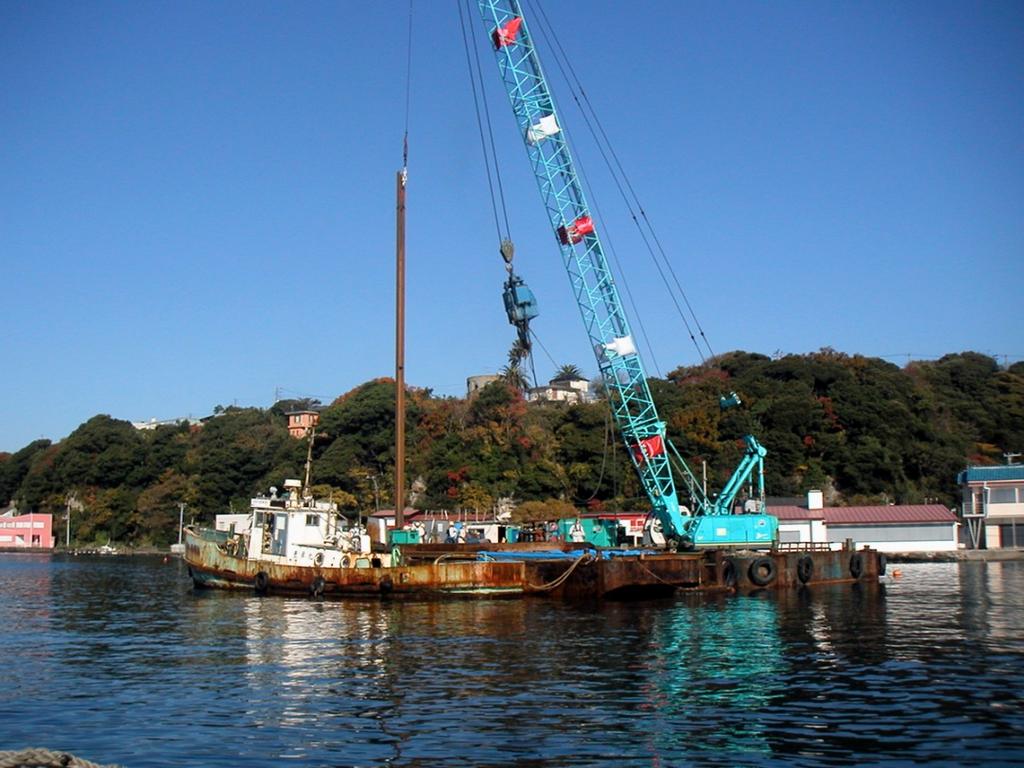
21 Long Geoslicer Survey
22 Long Geoslicer Survey


23 Long Geoslicer Survey Balanus yBP ( AD) ~ 1703 (Genroku) Kanto Eq. Shell in sand layer AD(Marine Reservoir correction applied) ~ 1293 Kanto Eq.
24 Miura Peninsula Koajiro Bay Aburatsubo Bay (tide gauge record since 1895) Ena Bay

25 Geoslicer survey in Ena Bay


26 Characteristics of Tsunami deposits in Ena Bay Three or four coarse layers including shell fragments, gravels, and coarse sand were identified in the inner bay fine sediments. These tsunami deposits erode layers below, indicating a strong current. Sedimentation environment clearly changes between below and above the tsunami deposits.

27 Diatom and grain size analyses Tide gauge record at Aburatsubo Planktonic > Benthic diatom : interseismic subsidence Planktonic < Benthic diatom : coseismic uplift
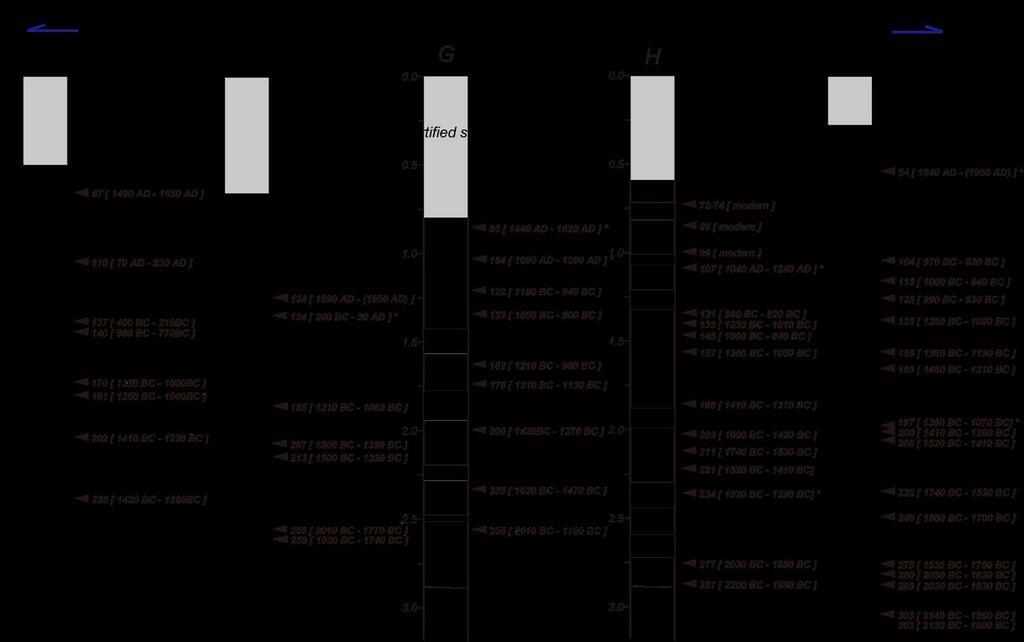
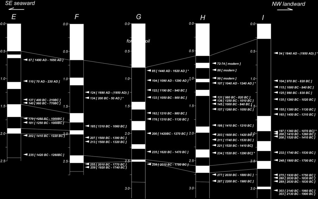
28 Radiocarbon Dating
29 Radiocarbon Dating and Sedimentation Rate ENA F ENA I T1 T1? T2 T3 T2 T4 T3 T4?? T5 Tidal flat Sub tidal Inner bay Tidal flat Sub tidal Inner bay
30 Comparison with Geomorphological study modified from Shishikura, 2003
31 Summary Three or four tsunami deposits are obtained in the inner bay fine sediment. In Koajiro Bay, the top and second tsunami deposits are correlated to the 1923 and 1703 Kanto earthquake. The third one may be 1293 earthquake recorded in historical literature. In Ena Bay, the topmost deposit is the 1923 Kanto earthquake. The second through fourth unit deposited about 3000, 3300 and 3700 year BP, respectively. In addition to tsunami deposits, diatom analysis provide coseismic and interseismic sea level changes.
Geological evidence of recurrent great Kanto earthquakes at the Miura Peninsula, Japan
 JOURNAL OF GEOPHYSICAL RESEARCH, VOL. 116,, doi:10.1029/2011jb008639, 2011 Geological evidence of recurrent great Kanto earthquakes at the Miura Peninsula, Japan K. Shimazaki, 1 H. Y. Kim, 1 T. Chiba,
Numerical Tsunami Propagation of 1703 Kanto Earthquake
 Numerical Tsunami Propagation of 1703 Kanto Earthquake Wu Yifei Supervisor: Kenji Satake Introduction Near Tokyo Bay, the 1703 Genroku Kanto Earthquake is known to generate a tsunami which hit the nearby
Forecasting Future Earthquakes from Tsunami Deposits and Simulation
 Forecasting Future Earthquakes from Tsunami Deposits and Simulation Kenji Satake Earthquake Research Institute The University of Tokyo satake@eri.u-tokyo.ac.jp Contents 1. Earthquake Recurrence and Forecast
Amplification of Tsunami Heights by Delayed Rupture of Great Earthquakes along the Nankai Trough
 Amplification of Tsunami Heights by Delayed Rupture of Great Earthquakes along the Nankai Trough Kentaro Imai 1,2, Kenji Satake 2 and Takashi Furumura 1,2 1 Center for Integrated Disaster Information Research,
J-Rapid PI: Jun Sasaki 1 T. Suzuki 1 and R. U. A. Wiyono 1. Rapid PI: Changsheng Chen 2 C. Beardsley 3, Z. Lai 2, R., H. Lin 2, J. Lin 3 and R.
 Collaborative Research: The Japan March 11 Earthquake: Tsunami inundation, and initial spread of Fukushima Dai-ichi Radionuclides into the Pacific Ocean: Model Assessment J-Rapid PI: Jun Sasaki 1 T. Suzuki
with tsunami simulation Author(s) Shishikura, Masanobu; Sawai, Y.; Na Symposium on Backwards Problem in G
 Shishikura, Masanobu; Sawai, Y.; Na Symposium on Backwards Problem in G") Reconstruction of the 869 Jogan Ear Titlethe 2011 Tohoku earthquake, by geol with tsunami simulation Author(s) Shishikura, Masanobu; Sawai, Y.; Na Proceeding of TC302 Symposium Osaka Citation Symposium
Reconstruction of the 869 Jogan Ear Titlethe 2011 Tohoku earthquake, by geol with tsunami simulation Author(s) Shishikura, Masanobu; Sawai, Y.; Na Proceeding of TC302 Symposium Osaka Citation Symposium
Correspondence to: O. Kazaoka Published: 12 November 2015
 doi:10.5194/piahs-372-221-2015 Author(s) 2015. CC Attribution 3.0 License. Subsidence by liquefaction-fluidization in man-made strata around Tokyo bay, Japan: from geological survey on damaged part at
Open Access FULL PAPER. Hideaki Yanagisawa 1* and Kazuhisa Goto 2
 DOI 10.1186/s40623-017-0713-4 FULL PAPER Open Access Source model of the 1703 Genroku Kanto earthquake tsunami based on historical documents and numerical simulations: modeling of an offshore fault along
Lessons from the 2004 Sumatra earthquake and the Asian tsunami
 Lessons from the 2004 Sumatra earthquake and the Asian tsunami Kenji Satake National Institute of Advanced Industrial Science and Technology Outline 1. The largest earthquake in the last 40 years 2. Tsunami
The 1700/01/26 Cascadia subduction zone Earthquake and Tsunami
 Jason R. Patton GEO 142 1/13/15 Abstract: Cascadia subduction zone earthquakes (CSZ) can generate strong ground shaking and deadly tsunamis. Geologists used sediment cores and stream bank exposures to
2013 SCEC Annual Report
 2013 SCEC Annual Report Collaborative research: Documentation of Tsunami Deposits in the Carpinteria Estuary: A signal of Great Earthquakes on the Pitas Point Thrust L. Reynolds, A. Simms, T.K. Rockwell,
Holocene evolution of Dahab coastline Gulf of Aqaba, Sinai Peninsula, Egypt 1
 Holocene evolution of Dahab coastline Gulf of Aqaba, Sinai Peninsula, Egypt 1 Magdy Torab* 2 * Prof. of Geomorphology, Department of Geography, Damanhour University, Egypt 3 E-mail: magdytorab@hotmail.com.
The 1923 Kanto earthquake reevaluated using a newly augmented geodetic data set
 JOURNAL OF GEOPHYSICAL RESEARCH, VOL. 111,, doi:10.1029/2005jb003628, 2006 The 1923 Kanto earthquake reevaluated using a newly augmented geodetic data set M. Nyst, 1,2 T. Nishimura, 3 F. F. Pollitz, 1
Earthquakes and Tsunamis
 Earthquakes and Tsunamis Kenji Satake Earthquake Research Institute University of Tokyo 1 Part I 2011 Tohoku earthquake and tsunami 2 Fukushima Dai ichi NPP accident Earthquake ground motion Reactors automatically
PROBABILISTIC LIQUEFACTION HAZARD ANALYSIS IN JAPAN
 SECED 2015 Conference: Earthquake Risk and Engineering towards a Resilient World 9-10 July 2015, Cambridge UK PROBABILISTIC LIQUEFACTION HAZARD ANALYSIS IN JAPAN Tetsushi KURITA 1 and Sei ichiro FUKUSHIMA
An analysis on the relationship between land subsidence and floods at the Kujukuri Plain in Chiba Prefecture, Japan
 doi:10.5194/piahs-372-163-2015 Author(s) 2015. CC Attribution 3.0 License. An analysis on the relationship between land subsidence and floods at the Kujukuri Plain in Chiba Prefecture, Japan Y. Ito 1,
Jasper Beach, Machiasport, Maine
 Maine Geologic Facts and Localities June, 2000 Jasper Beach, Machiasport, Maine 44 o 38 30.28 N, 67 o 22 31.96 W Text by Joesph T. Kelley, Department of Agriculture, Conservation & Forestry 1 Map by USGS
Land subsidence at the Kujukuri Plain in Chiba Prefecture, Japan: evaluation and monitoring environmental impacts
 Land Subsidence, Associated Hazards and the Role of Natural Resources Development (Proceedings of EISOLS 2010, Querétaro, Mexico, 17 22 October 2010). IAHS Publ. 339, 2010. 293 Land subsidence at the Kujukuri
Slip distributions of the 1944 Tonankai and 1946 Nankai earthquakes including the horizontal movement effect on tsunami generation
 Slip distributions of the 1944 Tonankai and 1946 Nankai earthquakes including the horizontal movement effect on tsunami generation Toshitaka Baba Research Program for Plate Dynamics, Institute for Frontier
A Study on the Risk Assessment of Emergency Supplies. Transportation Routes Considering Scenario Earthquakes
 ORIGINAL ARTICLE A Study on the Risk Assessment of Emergency Supplies Transportation s Considering Scenario Earthquakes Kazuaki Torisawa 1, Harumi Yashiro 2, Sei ichiro Fukushima 3*, Satoshi Kina 4 1 Kajima
CSU Student Research Competition Summary Submission
 Name: CSU Student Research Competition Summary Submission Shawn Morrish Title: Coseismic Uplift and Geomorphic Response to the September 5, 2012 Mw7.6 Nicoya Earthquake, Costa Rica Abstract: The Nicoya
Yuichi Niwa and Toshihiko Sugai
 Chapter 2 Geomorphology and Tectonic Setting of the Sanriku Coast, Northeastern Japan, and Introduction of Recent Studies on the Formation of Alluvial Plains and Holocene Crustal Movements Along the Coast
Tsunami Simulation of 2009 Dusky Sound Earthquake in New Zealand
 Tsunami Simulation of 2009 Dusky Sound Earthquake in New Zealand Polina Berezina 1 Institute of Geology, Taras Shevchenko National University of Kyiv, Kyiv, Ukraine Supervisor: Prof. Kenji Satake Earthquake
Groundwater and Coastal Phenomena Preceding the 1944 Tsunami (Tonankai Earthquake)
") Groundwater and Coastal Phenomena Preceding the 1944 Tsunami (Tonankai Earthquake) Masataka Ando Institute of Earth Sciences, Academia Sinica ando@earth.sinica.edu.tw Study Area Characteristics of large
Groundwater and Coastal Phenomena Preceding the 1944 Tsunami (Tonankai Earthquake) Masataka Ando Institute of Earth Sciences, Academia Sinica ando@earth.sinica.edu.tw Study Area Characteristics of large
4-3-1 Earthquake and Tsunami Countermeasures of Tokyo s
 4-3-1 Earthquake and Tsunami Countermeasures of Tokyo s Sewerage Masahiro Hikino* and Gaku Sato** *Planning Section, Planning and Coordinating Division, Bureau of Sewerage, Tokyo Metropolitan Government
Deep Seismic Profiling in the Tokyo Metropolitan Area for Strong Ground Motion Prediction
 Deep Seismic Profiling in the Tokyo Metropolitan Area for Strong Ground Motion Prediction Hiroshi Sato 1, Naoshi Hirata 1, Takaya Iwasaki 1, Kazuki Koketsu 1, Tanio Ito 2, Keiji Kasahara 3, Kiyoshi Ito
Foundations of Earth Science, 6e Lutgens, Tarbuck, & Tasa
 Foundations of Earth Science, 6e Lutgens, Tarbuck, & Tasa Oceans: The Last Frontier Foundations, 6e - Chapter 9 Stan Hatfield Southwestern Illinois College The vast world ocean Earth is often referred
Lecture Outlines PowerPoint. Chapter 13 Earth Science 11e Tarbuck/Lutgens
 Lecture Outlines PowerPoint Chapter 13 Earth Science 11e Tarbuck/Lutgens 2006 Pearson Prentice Hall This work is protected by United States copyright laws and is provided solely for the use of instructors
Time and Space Distribution of Coseismic Slip of the 2011 Tohoku Earthquake as. Inferred from Tsunami Waveform Data
 1 2 Time and Space Distribution of Coseismic Slip of the 2011 Tohoku Earthquake as Inferred from Tsunami Waveform Data 3 4 Kenji Satake 1, Yushiro Fujii 2, Tomoya Harada 1 and Yuichi Namegaya 3 5 6 7 8
Study of the liquefaction phenomenon due to an earthquake: case study of Urayasu city
 Disaster Management and Human Health Risk III 311 Study of the liquefaction phenomenon due to an earthquake: case study of Urayasu city S. Kamao 1, M. Takezawa 1, K. Yamada 1, S. Jinno 1, T. Shinoda 1
Preparation for Future Earthquake and Tsunami Hazards: Lessons Learned from the 2004 Sumatra-Andaman Earthquake and the Asian Tsunami
 First International Conference of Aceh and Indian Ocean Studies Organized by Asia Research Institute, National University of Singapore & Rehabilitation and Construction Executing Agency for Aceh and Nias
THREE-DIMENSIONAL FINITE DIFFERENCE SIMULATION OF LONG-PERIOD GROUND MOTION IN THE KANTO PLAIN, JAPAN
 THREE-DIMENSIONAL FINITE DIFFERENCE SIMULATION OF LONG-PERIOD GROUND MOTION IN THE KANTO PLAIN, JAPAN Nobuyuki YAMADA 1 And Hiroaki YAMANAKA 2 SUMMARY This study tried to simulate the long-period earthquake
Ground Motion Validation of the +3,- Kanto Earthquake Using the New Geometry of the Philippine Sea Slab and Integrated -D Velocity-Structure Model
 Bull. Earthq. Res. Inst. Univ. Tokyo Vol. 2+,**0 pp.,01,1, Ground Motion Validation of the +3,- Kanto Earthquake Using the New Geometry of the Philippine Sea Slab and Integrated -D Velocity-Structure Model
Tsunami source of the 2004 off the Kii Peninsula earthquakes inferred from offshore tsunami and coastal tide gauges
 LETTER Earth Planets Space, 57, 173 178, 2005 Tsunami source of the 2004 off the Kii Peninsula earthquakes inferred from offshore tsunami and coastal tide gauges Kenji Satake 1, Toshitaka Baba 2, Kenji
Study of Sand Boiling Characteristics Along Tokyo Bay During The 2011 Tohoku-Pacific Ocean Earthquake
 Study of Sand Boiling Characteristics Along Tokyo Bay During The 2011 Tohoku-Pacific Ocean Earthquake Keisuke Ishikawa Tokyo Denki University, Japan Susumu Yasuda Tokyo Denki University, Japan SUMMARY
The Ocean Floor Chapter 14. Essentials of Geology, 8e. Stan Hatfield and Ken Pinzke Southwestern Illinois College
 The Ocean Floor Chapter 14 Essentials of Geology, 8e Stan Hatfield and Ken Pinzke Southwestern Illinois College The vast world ocean Earth is often referred to as the water planet 71% of Earth s surface
SEISMIC RISK ANALYSIS FOR CITY GAS NETWORK IN SOUTHERN KANTO AREA, JAPAN ABSTRACT
 Proceedings of the 8 th U.S. National Conference on Earthquake Engineering April 18-22, 2006, San Francisco, California, USA Paper No. 1228 SEISMIC RISK ANALYSIS FOR CITY GAS NETWORK IN SOUTHERN KANTO
Journal of Earth Sciences and Geotechnical Engineering, vol. 4, no. 1, 2014, ISSN: (print), (online) Scienpress Ltd, 2014
, (online) Scienpress Ltd, 2014") Journal of Earth Sciences and Geotechnical Engineering, vol. 4, no. 1, 2014, 17-24 ISSN: 1792-9040 (print), 1792-9660 (online) Scienpress Ltd, 2014 Reconstruction of Relative Tectonic Movements Using Transgressive
Journal of Earth Sciences and Geotechnical Engineering, vol. 4, no. 1, 2014, 17-24 ISSN: 1792-9040 (print), 1792-9660 (online) Scienpress Ltd, 2014 Reconstruction of Relative Tectonic Movements Using Transgressive
This article is provided courtesy of the American Museum of Natural History.
 Avoiding Earthquake Surprises in the Pacific Northwest This article is provided courtesy of the American Museum of Natural History. How Vulnerable Is the Pacific Northwest? Cascadia is a region in the
Estimation of Damage Ratios of Wooden Houses and Water Distribution Pipelines in an Earthquake Scenario for the Tokyo Metropolitan Region
 The 2011 World Congress on Advances in Structural Engineering and Mechanics (ASEM'11 + ) Seoul, Korea, 18-22 September, 2011 Estimation of Damage Ratios of Wooden Houses and Water Distribution Pipelines
Continuously Monitored by JMA. Latitude: 34 13'10" N, Longitude: '11" E, Elevation: 572 m (Tenjosan) (Triangulation Point - Kozushima)
 (Triangulation Point - Kozushima)") 61. Kozushima Continuously Monitored by JMA Latitude: 34 13'10" N, Longitude: 139 09'11" E, Elevation: 572 m (Tenjosan) (Triangulation Point - Kozushima) Overview of Kozushima taken from south-southeast
61. Kozushima Continuously Monitored by JMA Latitude: 34 13'10" N, Longitude: 139 09'11" E, Elevation: 572 m (Tenjosan) (Triangulation Point - Kozushima) Overview of Kozushima taken from south-southeast
Earthquake prediction. Earthquake prediction: animals?
 Earthquake prediction Prediction: specifies that an earthquake of a specific magnitude will occur in a defined region during a particular period: There will be a M 7 or larger earthquake in southern California
Seismic Activity and Crustal Deformation after the 2011 Off the Pacific Coast of Tohoku Earthquake
 J-RAPID Symposium March 6-7, 2013 Seismic Activity and Crustal Deformation after the 2011 Off the Pacific Coast of Tohoku Earthquake Y. Honkura Tokyo Institute of Technology Japan Science and Technology
Scaling relations of seismic moment, rupture area, average slip, and asperity size for M~9 subduction-zone earthquakes
 GEOPHYSICAL RESEARCH LETTERS, VOL. 4, 7 74, doi:1.12/grl.976, 213 Scaling relations of seismic moment, rupture area, average slip, and asperity size for M~9 subduction-zone earthquakes Satoko Murotani,
Estimation of Deep Shear-Wave Velocity Profiles in Lima, Peru, Using Seismometers Arrays
 Calderon, D. et al. Paper: Estimation of Deep Shear-Wave Velocity Profiles in Lima, Peru, Diana Calderon, Zenon Aguilar, Fernando Lazares, Toru Sekiguchi, and Shoichi Nakai Faculty of Civil Engineering,
REPORT ON THE TSUNAMI DEPOSITS CAUSED BY THE 2011 OFF THE PACIFIC COAST OF TOHOKU EARTHQUAKE IN THE SOMA REGION, FUKUSHIMA PREFECTURE, NORTHEAST JAPAN
 GEOGRAPHICAL REPORTS OF TOKYO METROPOLITAN UNIVERSITY 47 (2012) 1-10 REPORT ON THE TSUNAMI DEPOSITS CAUSED BY THE 2011 OFF THE PACIFIC COAST OF TOHOKU EARTHQUAKE IN THE SOMA REGION, FUKUSHIMA PREFECTURE,
NUMERICAL SIMULATIONS FOR TSUNAMI FORECASTING AT PADANG CITY USING OFFSHORE TSUNAMI SENSORS
 NUMERICAL SIMULATIONS FOR TSUNAMI FORECASTING AT PADANG CITY USING OFFSHORE TSUNAMI SENSORS Setyoajie Prayoedhie Supervisor: Yushiro FUJII MEE10518 Bunichiro SHIBAZAKI ABSTRACT We conducted numerical simulations
Case study of Japan: Reference Frames in Practice
 Case study of Japan: Reference Frames in Practice Basara Miyahara and Koji Matsuo Sponsors: 1 Outline Introduction - Geodetic reference frame of Japan - GEONET : continuous GNSS observation system Geometric
REPORT ON THE TOHOKU AREA PASIFIC OFFSHORE EARTHQUAKE
 REPORT ON THE TOHOKU AREA PASIFIC OFFSHORE EARTHQUAKE GENERAL PERSPECTIVE The Highest Magnitude Ever Recorded The 2011 off the Pacific Coast of Tohoku Earthquake (hereafter, the 2011 Tohoku- Pacific Earthquake
Inversion Analysis of Historical Interplate Earthquakes Using Seismic Intensity Data
 Inversion Analysis of Historical Interplate Earthquakes Using Seismic Intensity Data Katsuhisa Kanda and Masayuki Takemura Kobori Research Complex, Kajima Corporation, Tokyo 107-8502, Japan Summary An
Earthquake Source. Kazuki Koketsu. Special Session: Great East Japan (Tohoku) Earthquake. Earthquake Research Institute, University of Tokyo
 Earthquake. Earthquake Research Institute, University of Tokyo") 2012/9/24 17:20-17:35 WCEE SS24.4 Special Session: Great East Japan (Tohoku) Earthquake Earthquake Source Kazuki Koketsu Earthquake Research Institute, University of Tokyo 1 Names and features of the earthquake
2012/9/24 17:20-17:35 WCEE SS24.4 Special Session: Great East Japan (Tohoku) Earthquake Earthquake Source Kazuki Koketsu Earthquake Research Institute, University of Tokyo 1 Names and features of the earthquake
Long-term Crustal Deformation in and around Japan, Simulated by a 3-D Plate Subduction Model
 Long-term Crustal Deformation in and around Japan, Simulated by a 3-D Plate Subduction Model Chihiro Hashimoto (1) and Mitsuhiro Matsu ura (2) (1) Institute of Frontier Research for Earth Evolution, Japan
PREDICTIONS OF EARTHQUAKE OCCURRENCE BEHAVIORS FROM ACTIVE FAULT SYSTEMS ACROSS THE JAPANESE ARCHIPELAGO BY STATISTICAL SIMULATIONS
 th World Conference on Earthquake Engineering Vancouver, B.C., Canada August -6, 4 Paper No. 5 PREDICTIONS OF EARTHQUAKE OCCURRENCE BEHAVIORS FROM ACTIVE FAULT SYSTEMS ACROSS THE JAPANESE ARCHIPELAGO BY
Detection of Kuril subduction-zone earthquakes from remote historic records in Honshu, Japan, between 1656 and 1867
 ANNALS OF GEOPHYSICS, VOL. 47, N. 2/3, April/June 2004 Detection of Kuril subduction-zone earthquakes from remote historic records in Honshu, Japan, between 1656 and 1867 Kenji Satake Active Fault Research
The development of palaeotsunami research
 The development of palaeotsunami research Sahra Skripsky, Undergraduate Student, Dalhousie University Abstract Over the last thirty years, the study of palaeotsunamis has received increasing attention.
TSUNAMI & STRATIGRAPHY
 TSUNAMI & STRATIGRAPHY Teacher s Manual Table of contents Summary... 82 Vocabulary... 83 Background Information... 84 Procedure... 85 Student Worksheet guide Plotting topographic profi les... 88 Drawing
Tsunami damage assessment of buildings in Chiba Prefecture, Japan using fragility function developed after the 2011 Tohoku-Oki Earthquake
 Safety, Reliability, Risk and Life-Cycle Performance of Structures & Infrastructures Deodatis, Ellingwood & Frangopol (Eds) 2013 Taylor & Francis Group, London, ISBN 978-1-138-00086-5 Tsunami damage assessment
RELATIONSHIP BETWEEN AGE OF GROUND AND LIQUEFACTION OCCURRENCE IN THE 2011 GREAT EAST JAPAN EARTHQUAKE
 Proceedings of the International Symposium on Engineering Lessons Learned from the 2011 Great East Japan Earthquake, March 1-4, 2012, Tokyo, Japan RELATIONSHIP BETWEEN AGE OF GROUND AND LIQUEFACTION OCCURRENCE
Re examination of the age of historical and paleo tsunami deposits at Koyadori on the Sanriku Coast, Northeast Japan
 DOI 10.1186/s40562-017-0077-4 RESEARCH LETTER Open Access Re examination of the age of historical and paleo tsunami deposits at Koyadori on the Sanriku Coast, Northeast Japan Daisuke Ishimura * Abstract
Real Time Monitoring System for Megathrust Earthquakes and Tsunamis - Cabled Network System and Buoy System in Japan -
 Real Time Monitoring System for Megathrust Earthquakes and Tsunamis - Cabled Network System and Buoy System in Japan - 1 Subduction zones around the world Haiti Italy Turkey Tohoku Sichuan Taiwan Sumatra
Predicting tsunami waves and currents on the West Coast of Canada: A case study for Ucluelet, BC
 Predicting tsunami waves and currents on the West Coast of Canada: A case study for Ucluelet, BC Josef Cherniawsky, Kelin Wang and Roy Walters Institute of Ocean Sciences, Fisheries & Oceans Canada Pacific
Powered by TCPDF (
 Powered by TCPDF (www.tcpdf.org) Title Influence of tsunamis on coastal lowlands : case of the 2011 Tohoku earthquake Sub Title 津波の海岸低地への影響 : 2011 年東北地方太平洋沖地震を例にして Author 松原, 彰子 (Matsubara, Akiko) Publisher
Annual Report for Research Work in the fiscal year 2005
 JST Basic Research Programs C R E S T (Core Research for Evolutional Science and Technology) Annual Report for Research Work in the fiscal year 2005 Research Area : High Performance Computing for Multi-scale
Small area of the ocean that is partially surrounded by land. The Ocean Basins. Three Major Oceans. Three Major Oceans. What is a SEA?
 The Ocean Basins How Deep is the Ocean? 1 2 Three Major Oceans Three Major Oceans Pacific Atlantic the shallowest ocean (3.3km average depth) Indian second shallowest ocean (3.8km average depth) Pacific
CHAPTER 1 INTRODUCTION
 1 CHAPTER 1 INTRODUCTION 1.1 GENERAL Washover sandsheets are often found in low-lying coastal embayment s (Sedgwick and Davis 2003). Washover deposition of marine sand is usually attributed to storm activity
Joint-inversion of Soil Profile with Receiver Function and Dispersion Curve using Arrays of Seismometers
 Joint-inversion of Soil Profile with Receiver Function and Dispersion Curve using Arrays of Seismometers D.Calderon 1, T.Sekiguchi 1, S.Nakai 1, Z.Aguilar 2, F.Lazares 2 1 Department of Urban Environment
Science 8 - Water Systems Test - Chapters 1-2
 Science 8 - Water Systems Test - Chapters 1-2 Multiple Choice (30 marks) Identify the choice that best completes the statement or answers the question. 1. What percentage represents the amount of fresh
Evidence for a slab fragment wedged under Tokyo and its tectonic and seismic implications
 Supplementary Information to accompany Evidence for a slab fragment wedged under Tokyo and its tectonic and seismic implications Shinji Toda, Ross S. Stein, Stephen H. Kirby, and Serkan B. Bozkurt This
Real time Monitoring System for Earthquakes and Tsunamis (DONET)
") Real time Monitoring System for Earthquakes and Tsunamis (DONET) NankaiTrough Yoshiyuki Kaneda Japan Agency for Marine-Earth Science and Technology (JAMSTEC) POGO@Seoul Presentation 1 Earthquakes in the
Real time Monitoring System for Earthquakes and Tsunamis (DONET) NankaiTrough Yoshiyuki Kaneda Japan Agency for Marine-Earth Science and Technology (JAMSTEC) POGO@Seoul Presentation 1 Earthquakes in the
Earthquake prediction. Southwest BC: Our local dangerous fault zones
 Earthquake prediction Prediction: specifies that an earthquake of a specific magnitude will occur in a defined region during a particular period: There will be a M 7 or larger earthquake in southern California
14.2 Ocean Floor Features Mapping the Ocean Floor
 14.2 Ocean Floor Features Mapping the Ocean Floor The ocean floor regions are the continental margins, the ocean basin floor, and the mid-ocean ridge. 14.2 Ocean Floor Features Continental Margins A continental
Piles for RC/Steel-frame buildings pulled up by tsunami at Onagawa Town, in the March 11 th 2011 East Japan Earthquake
 Piles for RC/Steel-frame buildings pulled up by tsunami at Onagawa Town, in the March 11 th 2011 East Japan Earthquake Kazuo KONAGAI 1, Takashi KIYOTA 2 and Hiroyuki KYOKAWA 3 1 Member of JSCE, Professor,
Subduction Zone Observatory
 Subduction Zone Observatory Observations made with simple tools can provide important scientific constraints. (can also combine with more sophisticated measurements). Standardized well-planned marine intertidal
APPLICATON OF SEAMLESS SIMULATION OF SEISMIC RESPONSE ANALYSIS AND HIGH RESOLUTION TSUNAMI SIMULATION TO COASTAL AREA OF SENDAI
 Proceedings of the International Symposium on Engineering Lessons Learned from the 2011 Great East Japan Earthquake, March 1-4, 2012, Tokyo, Japan APPLICATON OF SEAMLESS SIMULATION OF SEISMIC RESPONSE
Usually, only a couple of centuries of earthquake data is available, much shorter than the complete seismic cycle for most plate motions.
 Earthquake Hazard Analysis estimate the hazard presented by earthquakes in a given region Hazard analysis is related to long term prediction and provides a basis to expressed hazard in probabilistic terms.
What scientists know and do not know about the big one at Cascadia
 What scientists know and do not know about the big one at Cascadia Kelin Wang Pacific Geoscience Centre, Geological Survey of Canada Natural Resources Canada The Cascadia Subduction Zone M 7.3, 1946 Rupture
4. The map below shows a meandering stream. Points A, B, C, and D represent locations along the stream bottom.
 1. Sediment is deposited as a river enters a lake because the A) velocity of the river decreases B) force of gravity decreases C) volume of water increases D) slope of the river increases 2. Which diagram
Mamoru KOARAI and Takayuki NAKANO. (Published online: 18 December 2013) Abstract
 Abstract") Liquefaction damage in the Kanto region caused by the 2011 off the Pacific coast of Tohoku Earthquake in Japan, and the land condition of damaged areas detected by time-series geospatial information 21
Liquefaction damage in the Kanto region caused by the 2011 off the Pacific coast of Tohoku Earthquake in Japan, and the land condition of damaged areas detected by time-series geospatial information 21
Sediment erosion, resuspension, transportation and redeposition by tsunami: Evidences from the 2011 Tohoku-oki tsunami
 Paleotsunami Workshop 3 July 2013 Sediment erosion, resuspension, transportation and redeposition by tsunami: Evidences from the 2011 Tohoku-oki tsunami Ken Ikehara, Kazuko Usami (Geological Survey of
The Sea Floor. Chapter 2
 The Sea Floor Chapter 2 Geography of the Ocean Basins World ocean is the predominant feature on the Earth in total area Northern Hemisphere = 61% of the total area is ocean. Southern Hemisphere = about
Unit 1: Water Systems on Earth Chapter 2
 Unit 1: Water Systems on Earth Chapter 2 Create a mind map with the driving question, Why are Oceans Important? Remember: Why are oceans so important? Why are oceans so important? Primary water source
Coseismic slip distribution of the 1946 Nankai earthquake and aseismic slips caused by the earthquake
 Earth Planets Space, 53, 235 241, 2001 Coseismic slip distribution of the 1946 Nankai earthquake and aseismic slips caused by the earthquake Yuichiro Tanioka 1 and Kenji Satake 2 1 Meteorological Research
New Seismic Activity Model of Large Earthquakes along Nankai Trough for Probabilistic Seismic Hazard Maps
 New Seismic Activity Model of Large Earthquakes along Nankai Trough for Probabilistic Seismic Hazard Maps Toshihiko Okumura (Shimizu Corp.) Hiroyuki Fujiwara (NIED) Plate Tectonics around Japan Pacific
Strong ground motions from the 2011 off-the Pacific-Coast-of-Tohoku, Japan (Mw=9.0) earthquake obtained from a dense nationwide seismic network
 earthquake obtained from a dense nationwide seismic network") Landslides (2011) 8:333 338 DOI 10.1007/s10346-011-0279-3 Received: 10 June 2011 Accepted: 5 July 2011 Published online: 23 July 2011 The Author(s) 2011. This article is published with open access at Springerlink.com
Landslides (2011) 8:333 338 DOI 10.1007/s10346-011-0279-3 Received: 10 June 2011 Accepted: 5 July 2011 Published online: 23 July 2011 The Author(s) 2011. This article is published with open access at Springerlink.com
KIRSTY STYLES - EARTHQUAKE RISK SCIENTIST
 Aspen Opinion 1 ASPEN OPINION STRESS STATE IN JAPAN TWO YEARS ON KIRSTY STYLES - EARTHQUAKE RISK SCIENTIST Kirsty Styles PhD, summarizes key academic papers on the topic of Coulomb Stress Transfer (CST)
The great earthquakes that have shaped Japan 日本に大きな影響を与えた地震
 The great earthquakes that have shaped Japan 日本に大きな影響を与えた地震 Brian Kennett, Research School of Earth Sciences, ANU Takashi Furumura Earthquake Research Institute, University of Tokyo Japan tectonic plates
High Resolution Numerical Models of Tidal Marshes in the Delaware Bay
 High Resolution Numerical Models of Tidal Marshes in the Delaware Bay Ramona Stammermann Dept. of Civil, Architectural & Environmental Engineering, Drexel University, Philadelphia, PA Michael Piasecki
DATA REPOSITORY MATERIAL: PALEOCHANNEL GROUP MAPPING DESCRIPTIONS
 Data Repository item 2695 DATA REPOSITORY MATERIAL: PALEOCHANNEL GROUP MAPPING DESCRIPTIONS Groups 1 (North Myrtle Beach) and 2 (Atlantic Beach) Channel Groups 1 (North Myrtle Beach) and 2 (Atlantic Beach)
Evolution of Continents Chapter 20
 Evolution of Continents Chapter 20 Does not contain complete lecture notes. Mountain belts Orogenesis the processes that collectively produce a mountain belt Includes folding, thrust faulting, metamorphism,
MAR110 Lecture #5 Plate Tectonics-Earthquakes
 1 MAR110 Lecture #5 Plate Tectonics-Earthquakes Figure 5.0 Plate Formation & Subduction Destruction The formation of the ocean crust from magma that is upwelled into a pair of spreading centers. Pairs
The impact of the 2011 off the Pacific coast of Tohoku Earthquake on Tsukuba 32-m station
 7th IVS General Meeting Madrid, Spain March 4-9 2012 The impact of the 2011 off the Pacific coast of Tohoku Earthquake on Tsukuba 32-m station SHINOBU KURIHARA K. Kokado, J. Kuroda, M. Ishihara and R.
GEOL 10: Environmental Geology Mid Term II Study Guide
 (1) 10 pts. Use the seismographs below, along with the travel time plot for California, and the location map for seismographs in this region to do the following: a. Determine the origin time for the earthquake
Reconstruction of Geodetic Reference Frame after the 2011 off the Pacific Coast of Tohoku Earthquake
 Reconstruction of Geodetic Reference Frame after the 2011 off the Pacific Coast of Tohoku Earthquake Basara MIYAHARA, Takashi TOYOFUKU Tomoaki FURUYA, Yohei HIYAMA, Atsushi YAMAGIWA, Japan Key words: GNSS/GPS,
Identification of Gigantic Tsunami from the Kuril and Japan Trench based on Tsunami Sediments
 Identification of Gigantic Tsunami from the Kuril and Japan Trench based on Tsunami Sediments Kazuomi HIRAKAWA Professor Emeritus, Hokkaido Univ.) Taipei2013, 7.03 2011Tohoku Earthquake Tsunami inundation
BEACHROCK SAMPLES FROM THE NANSEI ISLANDS, SW JAPAN
 14 C AGE CORRECTIONS BASED ON ISOTOPE FRACTIONATIONS FOR BEACHROCK SAMPLES FROM THE NANSEI ISLANDS, SW JAPAN Kunio Omoto Department of Geography, College of Humanities and Sciences, Nihon University, 24-40,
Effect of the Emperor seamounts on trans-oceanic propagation of the 2006 Kuril Island earthquake tsunami
 GEOPHYSICAL RESEARCH LETTERS, VOL. 35, L02611, doi:10.1029/2007gl032129, 2008 Effect of the Emperor seamounts on trans-oceanic propagation of the 2006 Kuril Island earthquake tsunami S. Koshimura, 1 Y.
Active Tectonics. Earthquakes, Uplift, and Landscape. Edward A. Keller University of California, Santa Barbara
 Prentice Hall Earth Science Series SUB Gottingen 214 80416X, im ^, 2002 A 7883 lllllllilwii Active Tectonics Earthquakes, Uplift, and Landscape Second Edition V Edward A. Keller University of California,
RECIPE FOR PREDICTING STRONG GROUND MOTIONS FROM FUTURE LARGE INTRASLAB EARTHQUAKES
 RECIPE FOR PREDICTING STRONG GROUND MOTIONS FROM FUTURE LARGE INTRASLAB EARTHQUAKES T. Sasatani 1, S. Noguchi, T. Maeda 3, and N. Morikawa 4 1 Professor, Graduate School of Engineering, Hokkaido University,
Tsunami Protection Height Prediction
 Tsunami Protection Height Prediction Predicting Tsunamis Level I Tsunami Protection Height 1. Coastal structures protect property or help the evacuation process 2. For frequent but low-level events (several
2014 SCEC Proposal Progress Report March 31, 2015
 2014 SCEC Proposal Progress Report March 31, 2015 Distinguishing Tsunami-Generated from Flood-Generated Deposits in the Laminated Sediments of Santa Barbara Basin: An Untapped Repository of Deep-Time Paleoseismic