. '" A W L. c43""c*z. Mines a~,! ;.f+i7:ci!?? K C ~ O ~ ~ Ci. . i ix*:8du.ti- i. EUZt:,P...*.,...,,,... L. and
|
|
|
- Shawn Dickerson
- 5 years ago
- Views:
Transcription
1 BRITISH NEWFOUNDLAND EXPLORATION LIMITED GEOLOGICAL, PROSPECTING, AND DRILLING REPORT MARINI NO. 1 AND NO. 2 GROUPS OF MINERAL CLAIMS By: Michael G. Williams and Mohan Ramalingaswamy Mines a~,! ;.f+i7:ci!?? K C ~ O ~ ~ Ci B L. '" i -. >" A W L. c43""c*z NO ,... i ix*:8du.ti- i EUZt:,P...*.,...,,,... L i 1! BRINEX DOCUMENT NO. G74504 Claim Owner: Bernard J. Marini Vancouver, B. C., FIELD PERIOD: July 9 to September 12, 1974 REPORT PERIOD: October 14 to December 18, 1974
2 TABLE OF CONTENTS Page INTRODUCTION PROPERTY LOCATION AND ACCESS PURPOSE AND SCOPE OF EXPLORATION GEOLOGICAL MAPPING 1. Mapping Controls 2. Survey Procedures 3. Survey Results a) Stratigraphy b) Structure PROSPECTING 1. Survey Procedure 2. Survey Results DIAMOND DRILLING CONCLUSIONS REFERENCES APPENDICES: AND RECOMMENDATIONS 9 11 I I1 DRILL LOG M-74-1 ITEMIZEDMANDAYS OF WORK I11 DIAMOND DRILLING COSTS IV V CONSOLIDATED DECLARATION OF COSTS DIAMOND DRILLING CONTRACT
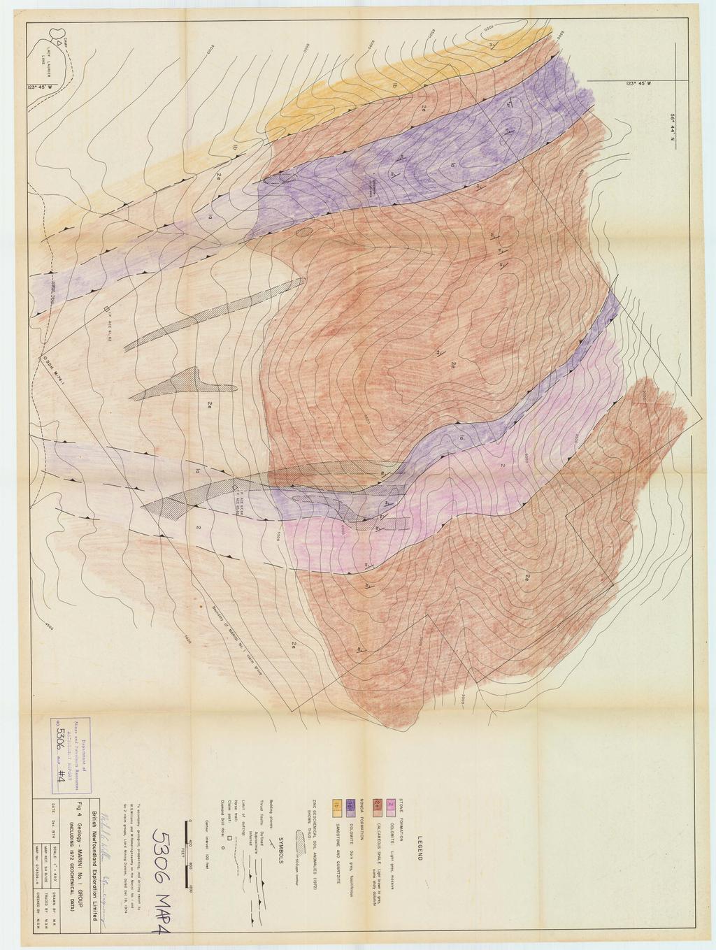
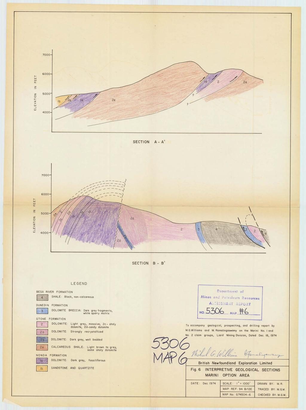
3 ILLUSTRATIONS: Page #I Fig. 1 Index Map After 1 #kjfig. 2 Claim Location Map After 2 #3Fig. 3 Geology Map - Marini Option Area 1" = 1000' Back Pocket *4-~i~. 4 Geology Map - Marini No. 1 Group 1" = 400' Back Pocket #5 Fig. 5 Geology Map - Marini NO. 2 Group 1" = 400' Back Pocket -+ $Fig. 6 Interpretive Geological Sect ions Back Pocket
4 INTRODUCTION This report describes the geological mapping, prospecting and diamond drilling carried out during the 1974 field season on the Marini No. 1 and No. 2 claim groups near Lady Laurier Lake in the Liard Minind Division. The area is about 15 miles south of Robb Lake. The exploration programme was conducted by British Newfoundland Exploration Limited under the terms of a joint venture agreement with Metallgesellschaft Canada Ltd. The Index Map (Fig. 1) shows the location of all plans with respect to the claim groups and to the geographic co-ordinates. The principals involved in the programme are: Dr. Neil Westoll, Manager - Western Exploration British Newfoundland Exploration Limited West Hastings Street, Vancouver, B.C. V6B 1P2 Dr. Dieter Muller, Metallgesellschaft Canada Ltd Frankfurt (Main) 1 Post Box 37 24, Reuterweg 14, West Germany Mr. Mohan Ramalingaswamy, c/o Department of Geology, University of Washington Seattle, Washington Mr. Michael G. Williams, Regional Geologist, British Newfoundland Exploration Limited West Hastings Street, Vancouver, B.C. V6B 1P2
5 Figure I. INDEX MAP - MARIN I OPTION SCALE: I : 50,000 MAP No. G MAP REF: 94 B/12E DRAWN BY: M. G.W. LIARD M. D. DATE: Dee. 1974
6 PROPERTY LOCATION AND ACCESS This report concerns 59 located mineral claims owned by Bernard Marini and partners, Vancouver, B.C., and optioned from them by Brinex. These claims are divided into two groups, Marini No. 1 Group (38 claims) and Marini No. 2 Group (21 claims) as shown on the claim map (Fig. 2). The Marini No. 1 group lies immediately northeast, and the Marini No. 2 group lies about 3 miles southwest of Lady Laurier Lake in the Liard Mining Division. The area is in the centre of the Rocky Mountain crest, 110 miles north of Mackenzie, B. C. near the headwaters of the Graham River. It is accessible by float-equipped fixed-wing aircraft which can land on Lady Laurier Lake, and by a horsetrail which leads to the area from Christina Falls ranch, 26 miles to the southeast. The topography is youthful and rugged, with elevations varying between 4,000' and 7,000'. Traversing on foot is not difficult, but on the higher ridges it is most effectively carried out with helicopter support. PURPOSE AND SCOPE OF EXPLORATION Field exploration in 1972 and 1973 on these claim groups (West011 and Sullivan, 1972; Pearson, 1973) established the presence of weak zinc, lead and silver geochemical anomalies in an area underlain by a succession of Palaeozoic sediments and carbonates with features characteristic of the host rocks of knwn lead-zinc ore deposits.
7 I Figure 2 CLAIM LOCATION MAP I SCALE: I" = 4500' DRAWN BY; B.D.P. MAP REF: 94 B/12E. TRACED BY: M.G.W. MAP No CHECKED BY: M.G.W.
8 The 1974 field programme was designed to follow-up the previous work by doing detailed geological mapping, systematic prospecting using a zinc oxide test solution, and a limited amount of diamond drilling using a lightweight Winkie drill. The geological mapping was carried out at a scale of 1" = 400' by M. Ramalingaswamy, and is described by him in the following section. Prospecting was carried out by Jim Winslaw and Nils Hagglund under the direction of the senior author. Only one drill hole was completed on the property before an early storm brought an end to the field season in September. Exploration was carried out on the Marini claims with helicopter support from a field base camp at Lady Laurier Lake. This work was done in conjunction with work on other claim groups in the Robb Lake Area, and support costs have been apportioned fairly among the various projects. This has allowed work to be carried out on the Marini claims more economically than would otherwise have been possible. GEOLOGICAL MAPPING 1. map pin^ Controls The mapping was carried out by plotting observations on acetate overlays on existing aerial photographs. Data were later transferred onto topographic maps at scales of 1" = 1000' (Fig. 3) and 1" = 400' (Figs. 4, 5). 2. Survey Procedures The mapping was carried out on foot concentrating on lithological and textural variations in bedrock, using Dickie's and Katayama's geological
9 maps as base maps (Pearson, 1973). Revisions were made in their results where necessary. Rock exposure is about 50 to 70 percent. Bedding attitudes were plotted where found. Where no outcrops are present, lithology and structure is inferred from talus and by projection along strike from exposed areas. Sections were drawn normal to strike. A total of six days were spent mapping in the area. 3. Survey Results a) Stratigraphy The stratigraphy in the area was described in detail by Dickie (West011 and Sullivan, 1972) and by Pearson (1973). Their terminology was used as the basis for this year's mapping. Revi- sions were incorporated where necessary. Silurian The oldest rocks in the claim area, belonging to the Nonda Formation, are of Silurian age. They consist of well-bedded dark banded fossili- ferous cherty dolomites, sandstones and quartzites. This sequence is very well exposed on Marini No. 1 group and on the northwestern side of Reef Mountain on Marini No. 2 group. It occurs in a series of imbricate thrust slices in the former area and in the core of the northwestward plunging anticline in the latter area. Lower Devonian The Lower Devonian section is represented in the area by the Stone
10 Formation. It consists of light grey dolomites, sandy and fossiliferous in places. Katayama describes a sharp facies change and considerable variations in thickness within the Stone Formation but the author feels that the facies change is gradual from a more sandy facies a few miles to the southeast to an almost sand-free facies on the southeastern side of Reef Mountain. The porosity and recrystallization increases dramatically on Reef Mountain, West of Reef Mountain, on the west side of a major north-south trending cross fault, the Stone Formation is substantially thinner. Here the exposed Stone Formation consists of well-bedded light grey dolomite interbedded with calcareous shales and sandstones and is overlain by a thick sequence of calcareous shales. The latter shales may be a facies equivalent of the upper Stone Formation on the west side of Reef Mountain, as they do not occur on the east side of the fault. Middle Devonian The rocks of this age are represented by the Dunedin Formation. It consists of dark grey dolomite, fossiliferous in places and is characterized by strong brecciation and recrystallization. The matrix in the breccia is sparry white dolomite with some secondary quartz. The unit exhibits two stages of brecciation, possibly tectonic brecciation superimposed on the primary sedimentary brecciation, Tectonic brecciated zones seem to occur sporadically across strike. The larger fragments tend to be very angular, and are surrounded by smaller angular fragments. The sedimentary brecciated zones can be traced along bedding planes (collapse
11 breccias?, talus breccias? etc.). The Dunedin Formation is not present in the Marini No. 1 area and is very thin in the Reef Mountain area. Middle Devonian to Mississippian The Besa River Formation is the uppermost unit in the Marini claims area. It consists of very fissile, black, non-calcareous shales. It weathers recessively in marked contrast with other units which are mostly carbonates. Fine-grained pyrite occurs within the shales, which is probably syngenetic or diagenetic. b) Structure Marini No. 1 Area In the area underlying the Marini No. 1 group of claims a number of relatively thin imbricate thrust slices occur. Some of these are conspicuous especially in a section on one of the ridges in the area. The thrust planes are fairly gently dipping, with noticeable deformation in the hanging walls. Furthermore, there is repetition of lithologies across strike. Others were recognized by palaeontological discontinuities by Dickie (1972). All the beds in the area dip to the southwest fairly steeply. Reef Mountain Area (Marini No. 2) A major north-south trending cross-fault has brought different lithologies on either side in structural contact. On the east side of the fault light grey dolomites of the Stone Formation are-
12 exposed. This sequence is sandy in a few places and contains a dark dolomite unit which is conspicuous at the higher parts of Reef Mountain. This unit cannot be traced eastward because of talus cover, but the same unit is again exposed in the creek east of Reef Mountain, and demonstrates the presence of a northeasterly dipping monoclinal sequence. On the western side of the fault,dark banded fossiliferous, cherty dolomites are exposed. These are overlain by thin light grey dolo- mites interbedded with shales and sandstones which in turn are overlain by calcareous shales. Together, these units represent the Devonian section and define an anticline plunging to the northwest. The Devonian section on this side of the fault is notably thinner than that to the southeast. PROSPECTING 1. Survey Procedure Prospecting was carried out by detailed examination of outcrop areas, primarily by breaking rock and by the application of a zinc oxide test solution to oxidized rock surfaces. A major difficulty in prospecting for zinc in the Robb Lake area is the deceptive appearance of sphalerite in the carbonate host rocks. It is frequently pale buff to yellow in colour, and blends into the dolomite matrix on fresh surfaces; on weathered surfaces it is often simply not identifiable. Here the use of the test solution allows recognition of its presence.
13 The solution was developed and supplied by Vangeochem Lab of North Vancouver, B.C., and has proved to be an extremely valuable exploration tool. When the solution is dripped or sprayed onto an oxidized coating which contains over 5% ZnO, the surface turns bright red. Since only a very small zinc sulphide or carbonate content in the rock is sufficient to produce an extensive area of zinc oxide on the weathered surface, use of this technique enables the prospector to concentrate his effort in areas where the reaction occurs. 2. Survey Results One occurrence of sphalerite mineralization was located on the Marini No. 1 group. Disseminated sphalerite occurs in a number of fracture zones cutting across bedded calcareous shales. Because of the nature of the occurrence and the sedimentary environment, it is not considered to be very significant. The depositional environment represented by the section on Reef Mountain on the Marini No. 2 group is much more favourable. However, although the presence of extensive recrystallization and porosity with a gradual facies change is highly significant, no primary sulphides were observed. As was mentioned in the report by Pearson.(l973), finely disseminated hematite and limonite were observed in the vugs and cavities of the highly recrystallized dolomite. Some of this limonite analyzed 1600 ppm zinc. It is possible that primary sulphides may occur down below the surface zone of oxidation and that the limonite and hematite exposed on surface were formed after the primary sulphides had been leached out.
14 DIAMOND DRILLING Drilling was carried out with the light weight two man Winkie drill using IAX drill rods which produce a core diameter of 1 318". Drilling was undertaken to test an anomalous zone on the Marini No. 1 group in an area of little or no outcrop. It had been intended to place a fence of short holes across the zone, but only one hole, M-74-1, was completed before an early snow fall brought field activities to an end. Drill Hole M-74-1 This vertical hole was drilled to a depth of 183 feet. The hole penetrates a monotonous sequence of finely laminated dolomitic shale, or shaly dolomite. The laminae are frequently crenulated, and numerous small scale slip faults, with offsets of less than one inch, are common in places. Pyrite occurs as thin disseminations along fractures and at 44 feet a one foot zone contains approximately 10% pyrite. An assay of this interval gives results of less than 0.01% for copper, lead, and zinc. No valuable sulphides were observed in the drill hole. The drill log is included in this report as Appendix I. The drill core is stored at the camp site at the northwest end of Lady Laurier Lake. CONCLUSIONS AND RECOMMENDATIONS Marini No. 1 Group This area is underlain by calcareous shales and carbonate units lacking the
15 characteristics such as porosity and recrystallization indicative of a favourable environment for Mississippi Valley type lead-zinc mineralization. Further work on these claims should be dependent on encouraging results from further work on the Marini No. 2 group to the south. Marini No. 2 Group The presence of strongly recrystallized and porous dolomite on Reef Mountain, adjacent to a facies change, is a highly significant factor in the search for lead-zinc mineralization. Although no sulphides were observed in this area, their absence could well be explained by the deeply oxidized surface zone. 0 Further work is warranted here. The bedrock below the oxidized zone should be examined by a number of short exploratory drill holes, particularly in those zones where brecciation due to dolornitization is apparent and where nodules of limonitic gossan are present. Respectfully submitted, December 18, 1974 Mohdn Ramalingaswamy
16 REFERENCES Dickie, G.: Devonian and Silurian Rocks between Mount Bertha and Nabesche River, North Eastern B.C., Brinex Report No. G Pearson, B.D.: Geological and Geochemical Report, Marini No. 1 and No. 2 Groups of Mineral Claims, Lady Laurier Lake, Liard Mining Division, B.C., December 14, Brinex Report No. G Westoll, N.D.S. and Sullivan, J.: Geological and Geochemical Report, Lake, Horn and Reef Groups of Mineral Claims, Lake Lady Laurier, Liard M. D., B. C., October 14, Brinex Report No. G i
17 APPENDIX I DRILL LOG Diamond Drill Hole M-74-1
18 HOLE NO. M-74-1 Page I of COORDINATE3: HOLE STARTED: Sepfc~ber 5, l?7+ HOLE COMPLETED: ~ep)e~her 12, 1774 DRILLED BY: MINK INTERNATIONAL HORlZ PROJ.: VERT PROJ.: 183' CORE SIZE: 14X - 1 % " RECOVERY: 95 ~ / o
19 HOLE NO. M PROJECT MARINI OPTION Page 2 of C
20 HOLE NO. M- 74 -I PROJECT M~~rnrl OpT,o~ INCLINATION:~OD. AZIMUTH: COORDINATES: LOQQED BY: F7.R. Page -2 of &
21
22 STATEMENT OF QUALIFICATIONS I, V. Mohan Ramalingaswamy, do hereby certify that: 1) I am a geologist residing at 1120 Heywood Street, North Vancouver, B.C. 2) I am a graduate of the Indian Institute of Technology, Kharagpur, India(B.Sc. Honours, Geological Sciences, 1968) 3) I am presently doing graduate studies in Economic Geology at the University of Washington, Seattle, Washington, U. S.A. and I expect to obtain an M.Sc. degree in March, ) I was employed by British Newfoundland Exploration Limited to do geological mapping in the Lady Laurier Lake area in northern B. C. during the 1974 field season. I I B V. oha an Ramalingaswamy
23 APPENDIX I1 ITEMIZED MANDAYS OF WORK MARINI GROUPS 1 AND 2 CLAIM GROUP PERSONNEL SALARY W I N 1 NO. 1 W I N 1 NO. 2 ($/DAY) MANDAYS TOTAL MAN DAYS TOTAL WILLIAMS MULLER RAMALINGASWAMY MADER WINSLOW HAGGLUND BRYAN CHATTERJEE PA1 SLEY MERCER McAUGHTRIE Work was carried out between July 9 and September 12, TOTALS APPENDIX I1 I DIAMOND DRILLSNG COSTS (MINI NO. 1 GROUP) IAX CORE $ $1, AX CASING $ lo $100/SHIFT = 1, SHIPPING CHARGES, MATERIALS ETC (PRO RATA) = FOOD AND ACCOMMODATION (DRILL CREW ONLY) $3,011.66
24 APPENDIX IV CONSOLIDATED DECLARATION OF COSTS MARINI NO. 1 AND NO. 2 CLAIM GROUPS CLAIM GROUP EXPENSES MARINI NO. 1 GROUP MARINI NO. 2 GROUP Geological Prospecting Drilling Geological Prospecting SALARIES $ $ $ $ $ FOOD AND ACCOMMODATION DRILLING - - 3, HELICOPTER COSTS , FIXED WING SUPPORT TRAVEL COSTS REPORT PREPARATION TOTALS $1, $ $5, $2, $ TOTAL COST: M I N I NO. 1 GROUP - $7, M I N I NO. 2 GROUP - $3,075.42
25 APPENDIX V DIAMOND DRILLING CONTRACT
26 \ ' CONTRACTORS 81 CONSULTANTS TELEPHONE: (604) CABLE: 'WINKIE". DELTA, B.C., CANADA 4814 DOGWOOD DRIVE DELTA. B.C., CANADA WIS AGREEImn made this 19\C day of March, 1974, BETiJEEN: British Newfoundland Ekplorat ion Ltd. # Vest East ings Street, Vancouver, B. C. (hereinafter referred to as the company) AND : Wink International Exploration Drilling Co., Ltd Dogwood Drive, Delta, B'. C. (hereinafter referred to as the contractor) Whereas the Company requests that the Contractor perform certain surface Winkie diamond drilling located on their, property on Vancouver Island (maskine) Project No. 180; The Contractor will supply one Winkie drill, one driller and one helper, and all drilling equipment including diamond items to drill to a depth of 200 feet, recovering 1-3/8 inch dianeter cores; mininum footage guaranteed, 750 feet. The Company will supply Board and Lodging and all transportation without any charge to the Contractor. Charges for these services shall be at the rate of $7.25 per lineal foot drilled; drilling casing and reaming at the rate of $7.25 per lineal foot;. plus $ per shift per two man crew. These charges to go into effect when drill and crews leave Vancouver for the Company drill site and will be effective until drill crew and drilling equipment return to Vancouver. 4. The Contractor shall be responsible for and will pay promptly all dues and assessnents payable under any Workmen's Compensation Act, or other similar Acts, whether 3rovincial or Dominion, in respect to it employees. The Contractor is also covered with third party liability insurance, legal OAPR EXlNEX VANCOUVER, B. C. SURFACE & UNDERGROUND ALL SIZES WIRE LINE DRILLING - WlNKlE DRILL SPECIALISTS
27 -2- liability for bodily injury to or death of any person or damage to property in the amount of $300, A letter to this effect for proof of same will be mailed to your office, bdbk British Newfoundland Exploration Ltd, Exploration Drilling Ltd,
28 April 10, Fred W. Wink, President, Wink International bploration Drilling Ltd., 4814 Dogwood Drive, Delta, B.C. Dear Mr. Wink: BE: Rinkie Drill Contract. Klaskino Project Herewith please find two executed copies of your Winkie drill cmtractvith us for the Klaskino property on Vancouver Island (Project 180). The agreement is perfectly in order, but I vould like to add tvo clauses to it, one relating to the additional work ve wish to do in Northern B.C. d 0 the other to waste cleanup. I suggest that the follaring clauses be considered as added to the original agreement: A, In addition to the diamond drilling on the Klaskino property, the Contractor ia hereby requested to carry out surface Winkie diamond drilling on the Company86 property near Robb Lake in Kortheastern B.C. The minh footage guaran'teed will be 2,500 feet, and in all respects the provisions of the Klaskino agreement will apply to the additional drilling save as agreed by mutual consent. 8. During the course of the work, the Contractor shall at all times keep the Compauyga premises free frm accumulation of waste material or rubbish, and upon completion of thm work shall remove all toole, scaffoldings, surplue materials and rubbish, and leave the premises in a clean condition. The Contractor shall obsente and comply with all applicable Federal and Provincial lawe, regulation8 and orders relating to preventiond forest flres and sanitation in the bush.
29 Fred W, Wink, April 10, 1974, Page 2, Would you please signify acceptance of these additions to the original agreement by signing and returning to me oae copy of this letter, Thank you for your co-operation. I look forward to a productive srmmer, Yours sincerely, BRITISH NEWFOUNDLAND EXPLORATION LIMITED N. D. S. Wes toll, Hanager - Western Exploration Wink International Exploration Drilling Ltd.
30 I L STATEMENT OF QUALIFICATIONS I, F. Michael G. Williams, of Vancouver, British Columbia, do hereby certify that: 1) I am a geologist residing at Robson Street, Vancouver, B. C. 2) I am a graduate of the University of British Columbia (B.A.Sc. - Geological Engineering) 3) I hold the degree of Master of Science from McGill University, Montreal, P. Q. (Structural Geology, 1966) 4) I have been employed by British Newfoundland Exploration Limited since May 1970 as an exploration geologist with the responsibility of planning and carrying out comprehensive mineral exploration programs principally in the Province of Newfoundland and Labrador. 5) I am a member of the Geological Association of Canada and the Canadian Institute of Mining and Metallurgy. 6) I have applied for Registered Membership with the Association of Professional Engineers of the Province of British Columbia. 7) The work which is the subject of this report was carried out by crews under my supervision. Michael G. Williams, B.A. Sc., M. Sc. Regional Geologist BRITISH NEWFOUNDLAND EXPLORATION LIMITED West Hastings St., Vancouver, B. C.

31
32

33
34
BRITISH NEWFOUNDLAND EXPLORATION LIMITED PROSPECTING REPORT JR AND MARK CLAIMS LIARD MINING DIVISION, B. C. By: Michael G.
 BRITISH NEWFOUNDLAND EXPLORATION LIMITED PROSPECTING REPORT JR AND MARK CLAIMS LIARD MINING DIVISION, B. C. By: Michael G. Willia 6- "t f I - -- ---- --.--. Department af I Brinex Report No. ~74546,- NTS
PROSPECTING REPORT THE WALLACE CLAIM OMENICA MINING DIVISION. 54" x6" 3.d d. for. Reako Exlorat ions Ltd. Wallace Rev. C.G.
 PROSPECTING REPORT ON THE WALLACE CLAIM OMENICA MINING DIVISION 54"44 14 1x6" 3.d d by David A. Howard P.Eng. for Reako Exlorat ions Ltd. Claim Locat ion Wallace Rev. C.G. #1560 Dome Mountain Area 9 3
QUINTETTE COAL LIMITED 1979 EXPLORATION ASSESSMENT REPORT
 QUINTETTE COAL LIMITED 1979 EXPLORATION ASSESSMENT REPORT JANUARY 1980 TABLE OF CONTENTS 1.0 Introduction 1.1 Geological Mapping 1.2 Field Camp 2.0 Geology 2.1 Introduction 2.2 Stratigraphy 2.3 Structure
REPORT OF GEOLOGICAL MAPPING ON THE MICHEL COAL LICENSE #5177. LOCATION: KOOTENAY LAND DISTRICT NTS 82-G-7 4Y028 Lat f Long.
 i *. REPORT OF GEOLOGICAL MAPPING ON THE MICHEL COAL LICENSE #5177 LOCATION: KOOTENAY LAND DISTRICT NTS 82-G-7 4Y028 Lat. 114 40f Long. ESSO RESOURCES CANADA LIMITED WARD E. KILBY WORK: OCTOBER 17 - OCTOBER
1 CLAIMS GEOPHYSICAL REPORT ON BOYAL SITUATE NORTHEAST OF TILLICUM MOUNTAIN GOLD AREA BURTON - NAKUSP SIQCAEJ MINING DIVISION
 GEOPHYSICAL REPORT ON BOYAL 1 CLAIMS SITUATE NORTHEAST OF TILLICUM MOUNTAIN GOLD AREA BURTON - NAKUSP SIQCAEJ MINING DIVISION CONSULTING GEOLOGIST AUGUST 1983 VANCOUVER B *C INDEX INTRODUCTION ooa,.eoaaa.aaaoaaooaoa~ao~o
GEOLOGICAL MAPPING OF SKARNS ON THE SHEEP AND EWE CLAIMS, TURNAGAIN RIVER, B.C. DURING THE 1979 SUMMER SEASON
 GEOLOGICAL MAPPING OF SKARNS ON THE SHEEP AND EWE CLAIMS, TURNAGAIN RIVER, B.C. DURING THE 1979 SUMMER SEASON CLAIMS: Sheep 1 to 4 Ewe 1, 3, 4 to 8 Lamb 12 Fraction Liard Mining Division, B.C. NTS 104
compietea since tnat date, and wnicn comprisea btage I ot tne recommended
 compietea since tnat date, and wnicn comprisea btage I ot tne recommended four-stage program. GEOLOGY & MINERALIZATION The property situate6 on the southeast slope of Nickel Plate Mtn., and within the
=%REPORT RECONNAISSANCE OF CHISHOLM LAKE PROSPECT. October 25, 1977
 =%REPORT ON FIELD RECONNAISSANCE OF CHISHOLM LAKE PROSPECT October 25, 1977 Bruce D. Vincent Imperial Oil Limited, Minerals - Coal, CALGARY, ALBERTA CHISHOLM LAKE PROSPECT Introduction The Chisholm Lake
Lat. 52' 43' N Long ' W
 &A exploration ltd MINING ENGINEERING GEOLOGY- GEOPHYSICS 4570 HOSKINS ROAD, NORTH VANCOUVER, 6. C. TELEPHONE (804) 985,7921 V7K 2R1 GEOLOGICAL AND GEOCHEMICAL REPORT on the BLUE CLAIMS Cariboo Mining
2013 GEOLOGICAL ASSESSMENT REPORT SHERIDAN HILL PROPERTY
 2013 GEOLOGICAL ASSESSMENT REPORT ON THE SHERIDAN HILL PROPERTY NEW WESTMINSTER MINING DIVISION BRITISH COLUMBIA NTS 092G07 49 16 31 NORTH LATITUDE, 122 39 48 WEST LONGITUDE PREPARED FOR Sheridan Hill
Prospecting Report 'S Office i DB Property, B.C. -J Negro Creek Nelson Mining District NTS 82F.050. Operator: Kootenay Gold Inc.
 . '.' I"' i9 12 Prospecting Report 'S Office i DB Property, B.C. -J Negro Creek Nelson Mining District NTS 82F.050 Operator: Kootenay Gold Inc. Owner: Darlene Lavoie Work Performed Summer of 2007 Report
on the Diamond Drilling done on the LAKESIOE GROUP of Mineral Claims SLOCAN MINING DIVISION 82-F-14-W Long ' Lat '
 Assessment Work Report on the Diamond Drilling done on the LAKESIOE GROUP of Mineral Claims SLOCAN MINING DIVISION 82-F-14-W Long 117 22' Lat. 49 58' ADRIAN KESLER SILVERTON, B.C. operator LEVON RESOURCES
TABLE OF CONTENTS APPENDICES SUMMARY DRILL LOG STATEMENT OF QUALIFICATION STATEMENT OF EXPENDITURES LIST OF FIGURES
 ASSESSMENT WORK REPORT DIAMOND DRILLING PROGRAM AUGUST AND SEPTEMBER, 1980 ON CLAIMS Molly Tom 1-4 and 8 Omineca Mining Division NTS 93M/llU 55'35'N, 127"29'W by David A. Bending Owner: Operator: Texasgulf
July Exploring for Canadian Gold in the Rainy River District of Ontario
 July 2013 Exploring for Canadian Gold in the Rainy River District of Ontario 1 Forward Looking Statements Some of the statements in this document may be deemed to be "forward-looking statements". All statements
for the Greenwood Mining Division, B.C. NTS 82E/7W Latitude 49' 27' W, Longitude 118' 5 Prepared by a= D. Dylan Watt, B.Sc.
 t. b LOGnO: 37~ -08 m. ACTIO#: for the AMP AMP 2 AMP 3 t AMP 4 CLAIMS Greenwood Mining Division, B.C. NTS 82E/7W Latitude 49' 27' W, Longitude 8' 5 %E c,w zc *& a w Prepared by a= -4c. D. Dylan Watt, B.Sc.
PRECIOUS METALS. owner. JMT Services Corp. GEOCHPlICAL SAMPLING CHELASLIE WCE, NORTH CENTRAL, B.C. OMINECA MINING DIVISION NTS 93F/5E & 6W
 PRECIOUS METALS REPORT ON 1980 RECONNAISSANCE GEOCHPlICAL SAMPLING CHELASLIE WCE, NORTH CENTRAL, B.C. OMINECA MINING DIVISION NTS 93F/5E & 6W LATITUDE 53O28 N LONGITUDE 125O31 W DATES Qp WORK: JULY 10
TOPOGRAPHICAL SURVEY REPORT ON THE GREENDROP PROPERTY NEAR CHILLIWACK, B.C. 92-H-3/W
 TOPOGRAPHICAL SURVEY REPORT ON THE GREENDROP PROPERTY NEW WESTMINSTER M.D. NEAR CHILLIWACK, B.C. 92-H-3/W Location: The central pap of the claims is located at coordinates 49 08'N, latitude by 121 26'W,
CARIBOO - GRIZZLY ZINC PROJECT
 CARIBOO - GRIZZLY ZINC PROJECT The Grizzly Lake or Cariboo Zinc property straddles the gravel Weldwood 8400 logging road in the Grizzly Lake area about 55 kilometres northeast of Likely. Roads constructed
Summary of Rover Metals Geologic Mapping Program at the Up Town Gold Project, Northwest Territories
 October 13, 2017 Summary of Rover Metals Geologic Mapping Program at the Up Town Gold Project, Northwest Territories Vancouver, British Columbia, Canada - Rover Metals Corp., Rover, is pleased to provide
GEOLOGICAL MAPPING REPORT ON THE ASH MINERAL CLAIM OSOYOOS MINING DIVISION ASHNOLA RIVER MAP SHEET NTS M092,H019 MCBRIDE CREEK AREA, ASHNOLA RIVER,
 GEOLOGICAL MAPPING REPORT ON THE ASH MINERAL CLAIM OSOYOOS MINING DIVISION ASHNOLA RIVER MAP SHEET NTS M092,H019 LATITUDE 49 o O6, LONGITUDE 120 o 22 MCBRIDE CREEK AREA, ASHNOLA RIVER, KEREMEOS, B.C. CANADA
SECOND DRILL HOLE IHAD2 INTERSECTS MINERALIZED TAPLEY HILL FORMATION AND MINERALIZED BASEMENT IRON FORMATION
 Suite 304, 22 St Kilda Road St Kilda Vic 3182 Ph: +61 3 9692 7222; Fax: +61 3 9529 8057 For Immediate Release 14 th September 2007 SECOND DRILL HOLE IHAD2 INTERSECTS MINERALIZED TAPLEY HILL FORMATION AND
ASSESSMENT REPORT TITLE PAGE AND SUMMARY
 ASSESSMENT REPORT TITLE PAGE AND SUMMARY TITLE OF REPORT: Assessment Report on Andys Bridge Mineral Claim, Turnagain River Area TOTAL COST: $2,100 AUTHOR(S): Bruce w Downing SIGNATURE(S): Bruce W Downing
Geo chemi c a1 Rep or t SILVER KING FAST GROUP. H. S. Lazenby Geologist. Vancouver, B.C. 16 November 1967
 Geo chemi c a1 Rep or t on SILVER KING FAST GROUP 1967 Vancouver, B.C. 16 November 1967 H. S. Lazenby Geologist Contents Introduction P. 1 Method of Survey P. 1 Interpretation of Results p. L&2 Statement
REPORT ON A GEOLOGICAL MAPPING AND PROSPECTING PROGRAM LOOK PROPERTY
 b KOKANEE EXPLORATIONS LTDI I WNO. 0 I- n c/ REPORT ON A GEOLOGICAL MAPPING AND PROSPECTING PROGRAM LOOK PROPERTY LOOK 1-31, 36-43 CLAIMS FORT STEELE MINING DIVISION CRANBROOK AREA N.T.S. 82G/5W + 4E E:
ASX Announcement. 28 January Drill results indicate large Porphyry Copper Gold System at Peenam
 ASX Announcement 28 January 2010 Drill results indicate large Porphyry Copper Gold System at Peenam Highlights: 270 metres of visible copper (gold) mineralisation in first diamond core hole at Peenam Prospect
7 miles West of Kamloops, B.C.
 MINERAL RESOURCES BRANCH ASSEWAENT RiPORT of hole # 78-11 NO. drilled on the ZZ # 18 Claim of China Commercial Corporation Ltd situated 7 miles West of Kamloops, B.C. in the Kamloops Mining Division D.R.
Queensland Mining Corporation Limited
 Queensland Mining Corporation Limited ABN 61 109 962 469 ASX Release 29 th July 2011 Drilling Commenced at Duck Creek Copper-Gold Project, Cloncurry, North-west Queensland Highlights RC drilling has commenced
7 MILES WEST OF PORT HARDY, B.C.
 GEOPHYSICAL REPORT VERTICAL INTENSITY MAGNETOMEER SURVEY ON LUK CLAIMS, 7 MILES WEST OF PORT HARDY, B.C. 50' 127O SE BY R. E. SHIELDS UNDER SUPERVISION OF J. R. BILLINGSLEY FOR SECOND0 MINING LTD. (N.
April Exploring for Canadian Gold in the Rainy River District of Ontario
 April 2013 Exploring for Canadian Gold in the Rainy River District of Ontario 1 Forward Looking Statements This presentation may contain forward-looking statements including but not limited to comments
UNION MINIERE EXPLORATIONS AND MINING CORPORATION LIMITED ASSESSMENT REPORT ON FITINAT MINERAL CLAIM. Alberni Mining Division Record No.
 M F )( UNION MINIERE EXPLORATIONS AND MINING CORPORATION LIMITED Suite 200, 4299 Canada Way, Burnaby, B.C. V5G 1 H4 Telephone (604) 437-9491 ASSESSMENT REPORT ON GEOCHEMICAL SOIL SURVEYS AND ROCKSAMPLING
ASSESSMENT REPORT MAGNETOMETER SURVEY GOLDEN ROD, GOLDEN ROD #2. Long.: General Delivery, Vananda, B. C.
 ASSESSMENT REPORT MAGNETOMETER SURVEY GOLDEN ROD, GOLDEN ROD #2 t=/ NTS 92~110w Lat.: Long.: 49O 44' N 124O 34' W Owner: E. Johanson General Delivery, Vananda, B. C. Operator: Rhyolite Resources I nc.
RECONNAISSANCE GEOCHEMICAL SURVEY
 RECONNAISSANCE GEOCHEMICAL SURVEY LEGAL, RITA, LOUISE FR. (CHAPLEAU GROUP) REVERTED CROWN GRANTS CHAPLEAU CREEK AREAJ, SLOC& MINING DIVISION 82 F/11W Lat: 49'44" Long: 117"22'W MINERAL RESOURCES BRANCH
T'he Horn property comprises a group of forty. contiguous claims owned by Canadian Superior Exploration
 -1- INTRODUCTION T'he Horn property comprises a group of forty contiguous claims owned by Canadian Superior Exploration Limited. The group is located five miles nort'h of Motase Lake. In July and August,
For personal use only
 ASX ANNOUNCEMENT 31 August 2012 DRILLING SUCCESS CONTINUES AT GUCHAB Near surface copper mineralisation in drill core from GCDD0002 HIGHLIGHTS The pilot programme of diamond drilling at Guchab continues
The MAPLE BAY PROJECT Copper Silver - Gold
 The MAPLE BAY PROJECT Copper Silver - Gold Good grade and tonnage potential within close proximity to Tidewater The Maple Bay Copper Silver Gold Project covers highly favourable geological host rocks of
For personal use only
 HIGHLIGHTS THIS QUARTER EXPLORATION Very strong zinc-silver-lead (Zn-Ag-Pb) mineralisation confirmed in 2 sampling programs (Program 1 and Program 2) at the Riqueza Project. Two highly prospective Zn-Ag-Pb
A PRELIMINARY REPORT ON THE ZYMOST2 CLAIM GROtP, TERRACE, B.C.
 NATIVE EXPLORATIONS LTD. A PRELIMINARY REPORT ON THE ZYMOST2 CLAIM GROtP, TERRACE, B.C. INTRODUCTION': The Zymoetz claim group is, at present, held under option by Native Explorations Ltd.. On the 19th
Encouraging drill results from Paroo Range
 17 July 2012 The Manager ASX Company Announcements Office PO Box H224, Australia Square SYDNEY NSW 2001 Encouraging drill results from Paroo Range Highlights Significant uranium mineralisation at the 100%
Drilling Commences at Telfer West Gold Project
 Level 7, 600 Murray Street West Perth WA 6005 PO Box 273 West Perth WA 6872 P 08 9486 9455 F 08 6210 1578 www.enrl.com.au 17 November 2016 ASX : ENR Company Announcements Office Australian Securities Exchange
GEOPHYSICAL REPORT THE CAVZ CLAIMS
 GEOPHYSICAL REPORT Magnetometer Survey on THE CAVZ CLAIMS CAVZ M.C.'s 1 to 12, 15 to 26, 29 to 40, 45 to 54 Trail Peak, Omineca M.D. 13 miles northeast of Fort Babine 550 ) 126 S.E. by G.Podolsky J.Russell
BALFOUR MINING LTD. (N.P.L.) HAM GROUP 92-P-6, CLINTON M. D.8 B. C. Lat 51 17'N, GEOCHEMICAL REPORT. V. CUKOR, P. Eng.
 HAM GROUP 92-P-6, CLINTON M. D.8 B. C. Lat 51 17'N, GEOCHEMICAL REPORT. V. CUKOR, P. Eng.") 34q '7 BALFOUR MINING LTD. (N.P.L.) HAM GROUP 92-P-6, CLINTON M. D.8 B. C. Lat 51 17'N, Long 12lo14'W GEOCHEMICAL REPORT, V. CUKOR, P. Eng. January 31, 1972 TABLE OF CONTENTS 1. INTRODUCTION 2. PROPERTY,
34q '7 BALFOUR MINING LTD. (N.P.L.) HAM GROUP 92-P-6, CLINTON M. D.8 B. C. Lat 51 17'N, Long 12lo14'W GEOCHEMICAL REPORT, V. CUKOR, P. Eng. January 31, 1972 TABLE OF CONTENTS 1. INTRODUCTION 2. PROPERTY,
NTS 082F03SW N W U E N
 Prospecting Report JOCELYN CLAIM NTS 082F03SW N49 09 51 W 117 14 04 11U 482906E 5445737N NELSON MINING DIVISION Martin Ross PO Box 323 Salmo BC V0G 1Z0 Jan 31, 2012 PROSPECTING REPORT JOCELYN MINERAL CLAIM
Copper Reef to Drill Massive Sulphide Targets in Flin Flon
 12 Mitchell Road Tel: (204) 687-3500 Flin Flon, MB, R8A 1N1 CZC.CSE Fax: (204) 687-4762 copperreef.com February 28, 2019. Copper Reef to Drill Massive Sulphide Targets in Flin Flon Copper Reef Mining Corporation
CSA Mine Observations Applied to the Development of Regional Exploration Models
 CSA Mine Observations Applied to the Development of Regional Exploration Models 1 Introduction Recent work completed by the geology team has resulted in an improved understanding of the CSA mine system
PHYSICAL WORK REPORT. the BAY CLAIMS. Omineca Mining Division Smithers, British Columbia N.T.S. 93E 13E/W
 PHYSICAL WORK REPORT the BAY CLAIMS Omineca Mining Division Smithers, British Columbia a N.T.S. 93E 13E/W LATITUDE: 53 57 00 N I LONGITUDE: 127 45 OO W for Home Ventures Ltd. 1201-675 West Hastings Street
First Drill Hole Completed at Bluebush Zinc Project
 11 September 2017 Highlights First Drill Hole Completed at Bluebush Zinc Project The first drill hole (BB01-17) on the Bluebush Zinc Project has been completed at 431.9m Rocks prospective for SEDEX style
GEOPHYSICAL REPORT. Airborne Magnetometer Survey. of the SHEEP-GOAT GROUP OF MINERAL CLAIMS. near Li l looet, B.C.
 GEOPHYSICAL REPORT 977 Airborne Magnetometer Survey of the SHEEP-GOAT GROUP OF MINERAL CLAIMS near Li l looet, B.C. Lillooet Mining Division (Lat.51 'lot Long. 122 40' 7 5t0[2L05E. for DUFFEY LAKES MINES
NEW HAZELTON, OMINECA M.D.,
 PROSPECTING REPORT JUDI 1 TO 6 MINERAL CLAIMS NEW HAZELTON, OMINECA M.D., B.C. MAP 93M/4E, LAT. SS014'N, LONG. 127'33'W OWNED BY: A. L'ORSA ANTHONY L'ORSA Smithers, B.C. 21 February, 1981 TABLE OF CONTENTS
FIRST YEAR ASSESSMENT REPORT PROSPECTING LICENCE 16512M MARYSTOWN AREA, BURIN PENINSULA NTS 1M/3
 FIRST YEAR ASSESSMENT REPORT OF PROSPECTING ON LICENCE 16512M MARYSTOWN AREA, BURIN PENINSULA NTS 1M/3 BY NATHANIEL NOEL MSc. FOR E. MICHELE NOEL MINERAL LICENCES: 16512 M WORK CONDUCTED: MID-SEPTEMBER
Date Submitted: June General Nature of Report: Examination of Placer Samples
 General Nature of Report: Examination of Placer Samples Claim: Gold Channel, Record Number 3775!8 1 (Gold Channel Placer Property) Mining Division: Cariboo NTS 093 G 09 W and E Latitude 520 23 N' Longitude1210
Quaternary clays alluvial sands of the Shepparton Formation overlie the basement rocks.
 NAGAMBIE GOLDFIELD Regional Geological Setting The Nagambie Project is located within the Melbourne Structural Zone of Victoria. The lithologies range in age from the Upper Silurian Broadford Formation
n3a 92 C- /.I 4 tr November 6, 1979 J. F. MclNTYRE, P.ENG. CONSU LTlNG MINING ENGl NEER Map #92C-16 TRANS PACIFIC VENTURES LTD.
 TELEPHONE : 5 9 6-1331 J. F. MclNTYRE, P.ENG. CONSU LTlNG MINING ENGl NEER 6466 CAGELDU CRESCENT DELTA, B.C. CANADA TRANS PACIFIC VENTURES LTD. c i. SAMPLING AND GEOPHYSICAL REPORT CAP CLAIM, VICTORIA
GEOCSZNICAL - SURVEY. ICAMLOOPS Kl.D. 2'' 6;kr. HY "'f. Alfred R. Allen,P.Eng. 1 NO.%=...,... 6"- 'I.
 t i.i GEOCSZNICAL - SURVEY i p' ICAMLOOPS Kl.D. 2'' 6;kr HY 50-64 +."'f 121-51 NE 5-10-70 : 19-10-70 Alfred R. Allen,P.Eng. I) ' 1 6"- 'I. 1 NO.%=...,..... Q.C. EXPLORATIONS LTD. 2Cl- 535 Kowe Street Vancouver
ASSESSMENT REPORT GEOLOGICAL BRANCH. 50' 23 'North. GEOLOGICAL and GEOCHEMICAL SURVEYS ON THE. PUTNAM PROPERTY (Putnam Mineral Claim)
") GEOLOGICAL and GEOCHEMICAL SURVEYS ON THE PUTNAM PROPERTY (Putnam Mineral Claim) VERNON MINING DIVISION, B.C. GEOLOGICAL BRANCH ASSESSMENT REPORT NTS : Latitude: 82L17W 50' 23 'North LOCATION, ACCESS,
GEOLOGICAL and GEOCHEMICAL SURVEYS ON THE PUTNAM PROPERTY (Putnam Mineral Claim) VERNON MINING DIVISION, B.C. GEOLOGICAL BRANCH ASSESSMENT REPORT NTS : Latitude: 82L17W 50' 23 'North LOCATION, ACCESS,
49" 3-4 I4 I \ Y 59 tj
 ASSESSMENT REPORT Mary 4 FORT STEELE M.D. NTS 82G/5W 49" 3-4 4 \ Y 59 tj Owner: St. Eugene Mining Corporation Limited Operator : St. Eugene Mining Corporation Limited Author: John R. Wilson Date Submitted:
W. 1.NELSON Jr. P. ENG.
 GEOCHEMICAL AND GEOPHYSICAL SURVEY SNO GROUP CLAIMS W. 1.NELSON Jr. P. ENG. NORANDA EXPLORATION COMPANY, LIMITED OMINECA MINING DIVISION AUG. 17, 1971 - AUG. 29, 1971 TABLE OF CONTENTS - Page INTRODUCTION
Compilation Report Hawke Hill South. Licence No M NTS 01N/06. Newfoundland and Labrador. Submitted by Gordon E. Cooper and Kevin P.
 Compilation Report 2010 Hawke Hill South Licence No. 017282M NTS 01N/06 Newfoundland and Labrador Submitted by Gordon E. Cooper and Kevin P. Ryan For Kevin P. Ryan (Licence holder) January, 2011 Work Year:
Drilling Program Commences on Iron Oxide Copper Gold Targets
 3 June 2008 Manager Company Announcements Company Announcements Office Australian Stock Exchange Limited Level 10, 20 Bond Street SYDNEY NSW 2000 ABN 42 082 593 235 Electronic delivery No of pages: 6 Drilling
PROSPECTING REPORT. Broken Hill Property. EVENT # TENURE # Tenure Name: Broken Hill. New Westminster Mining Division Map 092H
 2009-2010 PROSPECTING REPORT Broken Hill Property EVENT # 4514071 TENURE # 600988 Tenure Name: Broken Hill New Westminster Mining Division Map 092H Central Coordinate Reference 121 24 26.2 W Longitude
Goliath Reports Grams Per Tonne Gold Equivalent Over 2 Metres Channel Cut at Golddigger in the Golden Triangle; Bulk Sample Recommended
 Goliath Reports 22.83 Grams Per Tonne Gold Equivalent Over 2 Metres Channel Cut at Golddigger in the Golden Triangle; Bulk Sample Recommended November 28, 2017 Goliath Resources Ltd. (TSX-V: GOT) (the
LME m averaging 0.65 g/t Au and 0.32% Cu, or 1.19 g/t Au Equiv LME m averaging 0.64 g/t Au and 0.11% Cu, or 0.
 Bellhaven Tops Previous Best Hole at the Middle Zone Deposit, La Mina Project, Colombia: LME-1072 134.39m at 0.65 g/t Au and 0.32%Cu, or 1.19 g/t Au Equivalent Medellin, Colombia May 14, 2012. Bellhaven
SECOND and THIRD YEAR ASSESSMENT REPORT PROSPECTING LICENCE M, ROCK CUT PROPERTY, NTS 1N/12, NEWFOUNDLAND. ROY FRENCH (licence holder )
") SECOND and THIRD YEAR ASSESSMENT REPORT Of PROSPECTING On LICENCE 013704M, ROCK CUT PROPERTY, NTS 1N/12, NEWFOUNDLAND. By ROY FRENCH (licence holder ) Work Conducted: Sept. 17, 2008 Nov. 03, 2009 Total
SECOND and THIRD YEAR ASSESSMENT REPORT Of PROSPECTING On LICENCE 013704M, ROCK CUT PROPERTY, NTS 1N/12, NEWFOUNDLAND. By ROY FRENCH (licence holder ) Work Conducted: Sept. 17, 2008 Nov. 03, 2009 Total
PROSPECTORS ASSISTANCE PROGRAM MINISTRY OF ENERGY AND MINES
 BRITISH COLUMBIA PROSPECTORS ASSISTANCE PROGRAM MINISTRY OF ENERGY AND MINES GEOLOGICAL SURVEY BRANCH PROGRAM YEAR: 1999/2000 REPORT #: PAP 99-l 6 NAME: KIM ANSCHETZ PROSPECTORS TlEPORT on the 99 LOUIS
32?un North of Hope, B.C.,
 Geological Reconnaissance Assessment Report on portions of the Gilt Creek Group (Mike, C.G., Julie, and Gilt Mineral Claims) Situated 32?un North of Hope, B.C., New Westminster Mining Division N 'P 97H/11W
Surface Trenching Highlights. Santos Target. To (m) Width (m) Au (g/t) Comment. (m) Santos (1)-includes internal dilution
 Width (m) Au (g/t) Comment. (m) Santos (1)-includes internal dilution") Goldplay Exploration announces surface trenching program results to date at the 100% owned El Habal Property: including 130 meters grading 1.86 g/t Au, 100 meters grading 1.20 g/t Au, 90 meters grading
Goldplay Exploration announces surface trenching program results to date at the 100% owned El Habal Property: including 130 meters grading 1.86 g/t Au, 100 meters grading 1.20 g/t Au, 90 meters grading
EMPIRE DEVELOPMENT COMPANY LIMITED
 EMPIRE DEVELOPMENT COMPANY LIMITED 1017-736 Granville Street Vancouver 2, B.C. January 17, 1966 Chief Gold Commissioner, Department of Mines & Petroleum Reso,urces, Victoria, B.C. Dear Sir: The field work
RE~ORT ON. J.F.V. MILLAR, P. Eng. GEOCHEMICAL SURVEY TIMBASKET AND MOGUL MINERAL CLAIMS. Kinbasket Lake, B. C. 51 degrees 118 degrees N.E.
 RE~ORT ON GEOCHEMICAL SURVEY TIMBASKET AND MOGUL MINERAL CLAIMS Kinbasket Lake, B. C. 51 degrees 118 degrees N.E. J.F.V. MILLAR, P. Eng. Lease held by J.F.V. MILLAR Work done Sept. 22 - Oct. 3, 1967. REPORT
Update on Columbus Gold's Eastside Gold Discovery in Nevada
 Columbus Gold Corporation 1090 Hamilton Street Vancouver, B.C. V6B 2R9 Phone: (604) 634-0970 Fax: (604) 634-0971 Toll Free: 1 888 818-1364 info@columbusgroup.com www.columbusgroup.com NEWS RELEASE Update
STEP-OUT DRILLING EXTENDS HIGH GRADE COPPER ZONE AT SYNDICATED S 100% BARBARA SOUTH LODE
 November 5th 2009 Manager Announcements Companies Announcements Office Australian Securities Exchange Limited Level 4, 20 Bridge Street Sydney NSW 2000 STEP-OUT DRILLING EXTENDS HIGH GRADE COPPER ZONE
ASSESSMENT REPORT ON THE PEAVINE PROJECT. DGW & Associates # Alberni Street, Vancouver, British Columbia, V6E 4V2
 ASSESSMENT REPORT ON THE PEAVINE PROJECT KAMLOOPS MINING DIVISION BRITISH COLUMBIA NTS 082M 12 Latitude 51 36' 19.0"North -- Longitude --119 47' 27.0"West UTM Zone 11, NAD 83 5720827N 306744E Prepared
PROSPECTING Survey Over the AULD PROPERTY Auld Township, Ontario
 PO Box 219, 14579 Government Road, Larder Lake, Ontario, P0K 1L0, Canada Phone (705) 643-2345 Fax (705) 643-2191 www.cxsltd.com PROSPECTING Survey Over the AULD PROPERTY C Jason Ploeger, B.Sc, P.Geo August
Gold c 8 Rl!TI I8 8 I0 n0 '8 Off VANCOUVER, B.C. btandard I Property
 ,- PROSPECTING REPORT For the 1 Gold c 8 Rl!TI I8 8 I0 n0 '8 Off ig@ VANCOUVER, B.C. btandard I Property I SALMON GOVERNMENT AGENT ARM I Tenure Number 554772 Revelstoke Mining Division, B.C. BCGS GRID
Pacific Empire Minerals Provides Copper King RC Drilling Results
 Pacific Empire Minerals Provides Copper King RC Drilling Results November 1, 2018 - Vancouver, BC, Canada - Pacific Empire Minerals Corp. (TSXV: PEMC) ( Pacific Empire, PEMC or the Company ), a hybrid
POTENTIAL OF THE DONGWE COPPER GOLD PROJECT
 POTENTIAL OF THE DONGWE COPPER GOLD PROJECT By Nathan Sabao, P.Geo. September 2015 1 TABLE OF CONTENTS Page 1.0 EXECUTIVE SUMMARY 1 2.0 LOCATION 2 3.0 ACCESS 2 4.0 GEOLOGY 3 5.0 PREVIOUS DRILLING 5 6.0
A B C PAD A HIGHLIGHTS
 Murchison Minerals Intercepts 12.30% Zinc, 0.70% Copper, 0.18% Lead and 42.03 g/t Silver 14.97% ZnEq over 6.37 Metres and Extends Known Limits of Brabant McKenzie VMS Deposit June 25, 2018 (Toronto, Ontario):
Jedway Enterprises Ltd st Ave, Surrey, BC V3S 3M3
 Jedway Enterprises Ltd. 104-19286 21 st Ave, Surrey, BC V3S 3M3 Prospecting Report on the Den (Den#1 to #4) Property, Takla Landing Area, Omineca Mining Division, British Columbia NTS 93N/12 Trim 093N052,093N062
ASSESShAENT REPORT Mines and Petroleum Resources. Department of. No* JIMMY MINERAL CLAIM FRANKLIN CREEK AREA, GREENWOOD M. D.
 GEOCHEMICAL REPORT ON JIMMY MINERAL CLAIM FRANKLIN CREEK AREA, GREENWOOD M. D. Lat. 49'35' OON, N.T.S. Long. 118O22' 00W 82-E-9 July 18-21, 1974 Vancouver, B.C. J.J. McDougall, P.Eng. July 21, 1974 * Department
A Prospecting Report on the Leo d Or Mineral Claims
 A Prospecting Report on the Leo d Or Mineral Claims Hnvilah Gold Mines Ltd. John Devlin Ande Rychter Leo d Or Claims 2202 C63 NTS, 32 L/7NNippkish 1264 W W, 508) 23$J o f Owner: M.S. Madnri /nay 25, 1987
News Release February 27, 2014 TSX SYMBOL: COP
 Suite 1280 625 Howe St Vancouver, B.C. V6C 2T6 February 27, 2014 TSX SYMBOL: COP www.coromining.com CORO ANNOUNCES DRILLING RESULTS FROM ITS EL DESESPERADO PROJECT, CHILE February 27 2014, Coro Mining
LUCKY BEN MINE PROJECT SEPTEMBER 2018 UPDATE
 LUCKY BEN MINE PROJECT SEPTEMBER 2018 UPDATE During the first week of July 2018 work was completed by our Geologist, Richard Morris, and support personnel to stake the Lucky Ben vein structure at surface
Fox 2-Record No. 2524
 F HELICOPTER E.M. AND MAGNETOMETER SURVEY OVER THE FOX CLAIMS, OMINECA MINING DISTRICT BRITISH COLUMBIA ON BEHALF OF OWNER MR. MIKE BOYLE Claims: Fox l-record No. 2523 Fox 2-Record No. 2524 Location 126'
IDM Mining s Underground Drilling Intersects g/t Au and g/t Ag over 6.80 Meters True Width at the Red Mountain Gold Project
 IDM Mining s Underground Drilling Intersects 18.70 g/t Au and 66.85 g/t Ag over 6.80 Meters True Width at the Red Mountain Gold Project November 22 nd, 2016, Vancouver, BC IDM Mining Ltd. (TSX.V:IDM) (
PROSPECTING REPORT. Silver Dollar Property. EVENT # TENURE # Tenure Name: GPEX Silver Dollar
 2008-2009 PROSPECTING REPORT Silver Dollar Property EVENT # 4267989 TENURE # 555462 Tenure Name: GPEX Silver Dollar Similkameen Mining Division Map 092H Central Coordinate Reference 120 06 26.9 W Longitude
REPORT. on the. Omineca Mining Division, British Columbia. Latitude N., Longitude W. NTS map sheet 93F/7E. James W. McLeod, P.Geo.
 REPORT on the CHU MOLYBDENUM PROPERTY Omineca Mining Division, British Columbia Latitude 53 21 N., Longitude 124 37 W. NTS map sheet 93F/7E James W. McLeod, P.Geo. on behalf of Mr. Chris Delorme TABLE
Cape Breton Island Mineral Inventory Studies: A Sandstone Quarry Development Opportunity at Graham River (NTS 11F/14), Inverness County
, Inverness County") Report of Activities 2001 23 Cape Breton Island Mineral Inventory Studies: A Sandstone Quarry Development Opportunity at Graham River (NTS 11F/14), Inverness County G. J. DeMont and J. E. Hawken Compilation
Report of Activities 2001 23 Cape Breton Island Mineral Inventory Studies: A Sandstone Quarry Development Opportunity at Graham River (NTS 11F/14), Inverness County G. J. DeMont and J. E. Hawken Compilation
Zinc One Reports Additional High-Grade Zinc Results From Surface Samples at Bongará Zinc Mine Project
 Zinc One Reports Additional High-Grade Zinc Results From Surface Samples at Bongará Zinc Mine Project 29% Zn Over 51.2 Metres Sampled at the Surface Vancouver, BC December 19, 2017 - Zinc One Resources
ENCOURAGING DRILLING RESULTS RECORDED AT BERNARD GOLD PROJECT. EXPLORATION PROGRAM TO BE ACCELERATED.
 3 February 2010 ASX ANNOUNCEMENT ENCOURAGING DRILLING RESULTS RECORDED AT BERNARD GOLD PROJECT. EXPLORATION PROGRAM TO BE ACCELERATED. HIGHLIGHTS Grass roots gold play with encouraging initial drilling
NTS 93L/9W GEOCHEMICAL AND GEOPHYSICAL REPORT MONA CLAIM OMINICA MINING DIVISION. Lati tude 54036'N; Longitude 'W
 GEOCHEMICAL AND GEOPHYSICAL REPORT ON MONA CLAIM OMINICA MINING DIVISION Lati tude 54036'N; Longitude 126018'W NTS 93L/9W April 1981 Paul Plicka Consulting Geologist LOCATION MAP INTRODUCTION TABLE OF
OSOYOOS UINING DIVISION. 49% - 20' North Latitude 120% - 05' West Longitude. GOOD HOPE RESOURCES LTD West Hastings Street Vancouver, B. C.
 REPORT ON HORSEFLY PROPERTY DIAMOND DRILLING - 1982 OSOYOOS UINING DIVISION 49% - 20' North Latitude 120% - 05' West Longitude 9 x It/YG FOR GOOD HOPE RESOURCES LTD. 1518-1177 West Hastings Street Vancouver,
QUARTERLY ACTIVITIES REPORT
 QUARTERLY ACTIVITIES REPORT FOR THE PERIOD ENDED 31 MARCH 2012 KEY POINTS Sabre has identified three significant mineralised Base Metal Trends within its Ongava Polymetallic project in northern Namibia
BALMORAL INTERSECTS g/t GOLD OVER 7.99 METRES, BUG LAKE SOUTH, DETOUR GOLD TREND PROJECT, QUEBEC
 TSX: BAR / OTCQX: BALMF October 8, 2014 For Immediate Release NR14-24 BALMORAL INTERSECTS 12.50 g/t GOLD OVER 7.99 METRES, BUG LAKE SOUTH, DETOUR GOLD TREND PROJECT, QUEBEC Continues to Expand High Grade
A GUIDE TO WRITING AN ASSESSMENT REPORT ON YOUR CLAIMS
 A GUIDE TO WRITING AN ASSESSMENT REPORT ON YOUR CLAIMS PLEASE NOTE! In the following pages, suggestions and advice are in italics, under each heading. Use as a guideline only. Items in bold should be changed
CONSULTING GEOLOGICAL 8: MINING ENGINEERS STINGS STREET DA V6E 2E9 GEOPHYSICAL SURVEY SILVER QUEEN 2 ZEBALLOS AREA. B.C.
 DOLMAGE CAMPBELL & ASSOCIATES (1 975) LTD. CONSULTING GEOLOGICAL 8: MINING ENGINEERS STINGS STREET DA V6E 2E9 '' 1E O L 0 G I C A.L B'x;&a:f2:#& 'SESSMENT REPObT 12, Assessment RESOURCES LTD. 111 ReDort
SAMPLE ID SAMPLE TYPE Au (g/t) Ag (g/t) Cu (%) AuEq**(g/t)
 Ag (g/t) Cu (%) AuEq**(g/t)") GOLDEN RIDGE RESOURCES DISCOVERS NEW ALKALIC CU-AU PORPHYRY TARGET ON ITS HANK PROJECT Kelowna, British Columbia November 22,2017 - Golden Ridge Resources Ltd. ( Golden Ridge or the Company ) (TSXV: GLDN).
GOLDEN RIDGE RESOURCES DISCOVERS NEW ALKALIC CU-AU PORPHYRY TARGET ON ITS HANK PROJECT Kelowna, British Columbia November 22,2017 - Golden Ridge Resources Ltd. ( Golden Ridge or the Company ) (TSXV: GLDN).
%+ '$# $) %, %*$ " $ $ ' %' !()'-!" %( %"%! " *'+ - % %$! $)! " $)!" !$ ' "! )( ! $ '%& ')- % % "!#( (( ((# $) ' ) ((* & *# ' % %"*# ( !!
 %, %*$ $ $ ' %' !()'-! %( %%! *'+ - % %$! $)! $)! !$ ' ! )( ! $ '%& ')- % % !#( (( ((# $) ' ) ((* & *# ' % %*# ( !!") 001L/14/0218 First Year Assessment Report of Prospecting, Rock and Stream Sediment Sampling On Licence 18880M, NTS 1L/14 Burin Peninsula Newfoundland and Labrador Submitted by: Keith Kelloway Work year:
001L/14/0218 First Year Assessment Report of Prospecting, Rock and Stream Sediment Sampling On Licence 18880M, NTS 1L/14 Burin Peninsula Newfoundland and Labrador Submitted by: Keith Kelloway Work year:
VANCOUVER, B.C. Tri 082F/ F/059
 GEOCHEMCAL REPORT t MAY L, 2006 Whbpper Mineral Claims Ailsa Lake Area Gold comm~ss16fl8f"s Offim on Mining Division VANCOUVER, B.C. Tri 082F/058 082F/059 3792 E 5486438 N Operator Kootenay Gold nc. Suite
'-7' REPORT ON A MAGNETOMETER SURVEY OVER PART OF THE MAX CLAIM GROUP 1-20 LAC LE JEUNE AREA KAMLOOPS MINING DIVISION KAMLOOPS, BRITISH COLUMBIA
 I,., - SUITE 102. 222 BELLEVUE WES t ANCOUVER, B. '-7' REPORT ON A I MAGNETOMETER SURVEY OVER PART OF THE MAX CLAIM GROUP 1-20 LAC LE JEUNE AREA KAMLOOPS MINING DIVISION KAMLOOPS, BRITISH COLUMBIA 50-30
ATON RETURNS 22.2 METRES OF 2.77 GRAMS PER TONNE GOLD EQUIVALENT FROM HAMAMA WEST; VISIBLE GOLD DISCOVERED AT BOHLOG
 FOR IMMEDIATE RELEASE: ATON RETURNS 22.2 METRES OF 2.77 GRAMS PER TONNE GOLD EQUIVALENT FROM HAMAMA WEST; VISIBLE GOLD DISCOVERED AT BOHLOG Vancouver, April XX, 2017: Aton Resources Inc. (AAN: TSX-V) (
PROSPECTING REPORT. Deneau Creek. EVENT # TENURE # Tenure Name: Deneau Creek. New Westminster Mining Division Map 092H
 2010-2011 PROSPECTING REPORT Deneau Creek EVENT # 4844921 TENURE # 578616 Tenure Name: Deneau Creek New Westminster Mining Division Map 092H Central Coordinate Reference 121 18 04.5 W Longitude 49 26 13.9
DIAMOND DRILL REPORT ON THE LOCATED IN THE OMINECA MINING DIVISION FAWNIE NOSE AREA LATITUDE: 53O 17' LONGITUDE: 125O 10' NTS 93F 6E
 GRANGES EXPLORATION AB CANADIAN DIVISION DIAMOND DRILL REPORT ON THE G, H and I CLAIM BLOCKS LOCATED IN THE OMINECA MINING DIVISION FAWNIE NOSE AREA LATITUDE: 53O 17' LONGITUDE: 125O 10' NTS 93F 6E. -.