GEOLOGIC SUBSURFACE CONDITIONS. October 31, 2017 Project No
|
|
|
- Arlene Dickerson
- 5 years ago
- Views:
Transcription
1 October 31, 2017 Project No Ms. Shawna Anderson San Dieguito River Park Joint Powers Authority Sycamore Creek Road Escondido, California Subject: Addendum to Geotechnical Evaluation Proposed Maintenance Facility San Dieguito River Park San Diego, California Dear Ms. Anderson: In accordance with your request, we have prepared this addendum letter to our original project geotechnical report (Ninyo & Moore, 2016) for the proposed Maintenance Facility at the San Dieguito River Park in San Diego, California (Project No ). Specifically, this addendum has been prepared to address the City of San Diego Geology Department s review comment requesting further evaluation of the potential for liquefaction. The City Cycle Issues, dated August 10, 2017, Comment #3 states The project site is located in Geologic Hazard Category 32 as shown on the City s Seismic Safety Study Geologic Hazards Maps and is characterized by a potential for liquefaction. Submit an addendum geotechnical investigation report that addresses liquefaction potential and potential consequences of soil liquefaction on the proposed project as required by San Diego Municipal Code Accordingly, this addendum letter provides supplemental information regarding the potential for liquefaction at the site and our additional recommendations. The recommendations presented below are considered supplemental, and the findings and recommendations provided in the referenced geotechnical report (Ninyo & Moore, 2016) remain valid. GEOLOGIC SUBSURFACE CONDITIONS Based on information provided in our original project geotechnical report (Ninyo & Moore, 2016), the proposed maintenance building location is situated in an area that was previously graded under observation and testing services performed by CTE (CTE, 2009). Furthermore, the compacted fill soil beneath the proposed maintenance building location is underlain by alluvial soils. In addition to the subsurface soil information presented in our original project geotechnical report (Ninyo & Moore, 2016), this supplemental analysis includes soil information from the 5710 Ruffin Road San Diego, California p
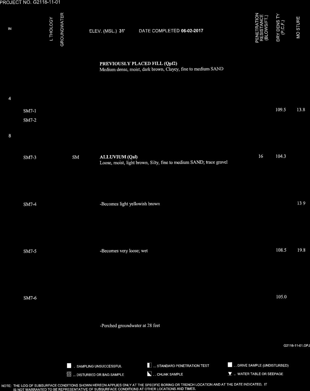
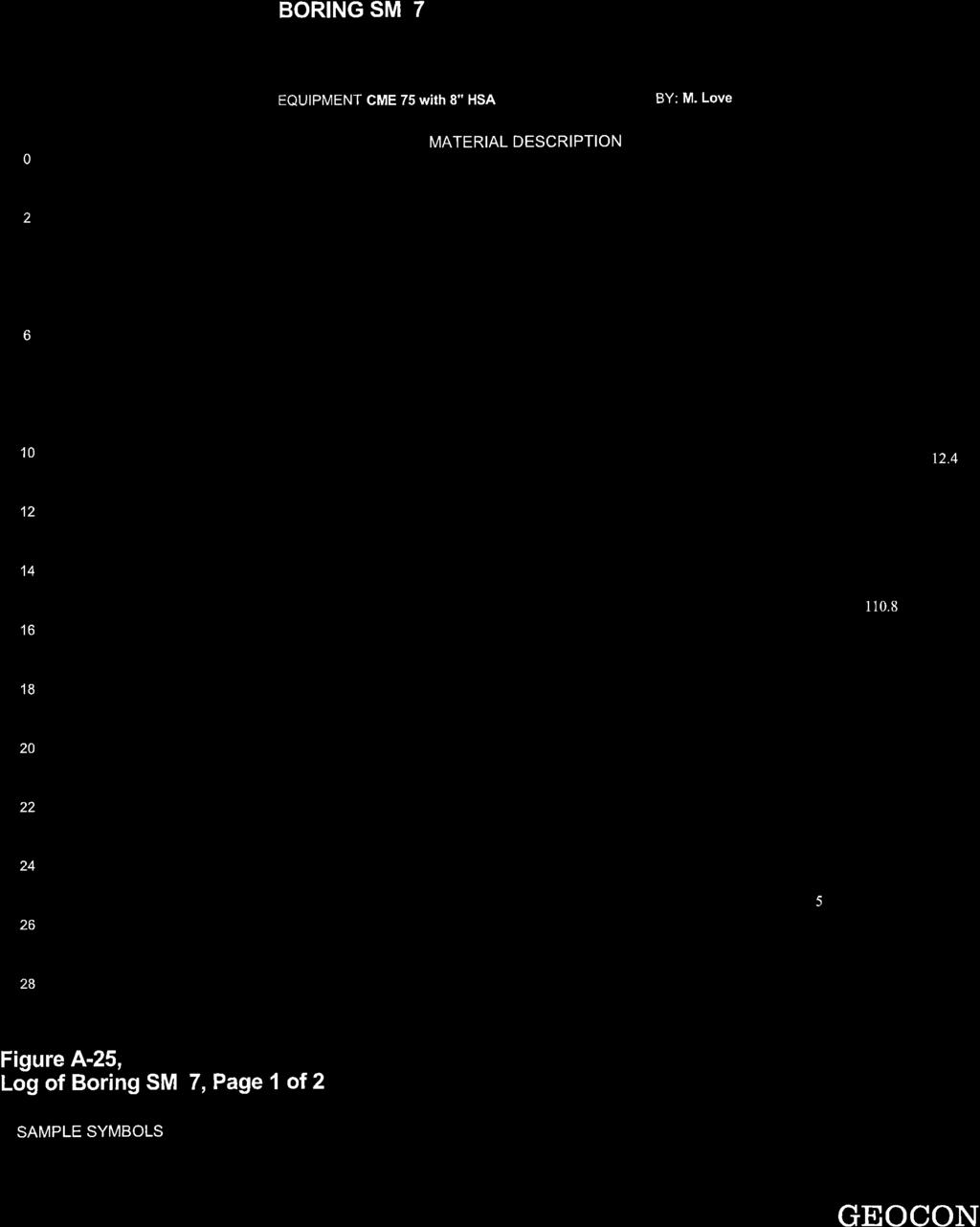
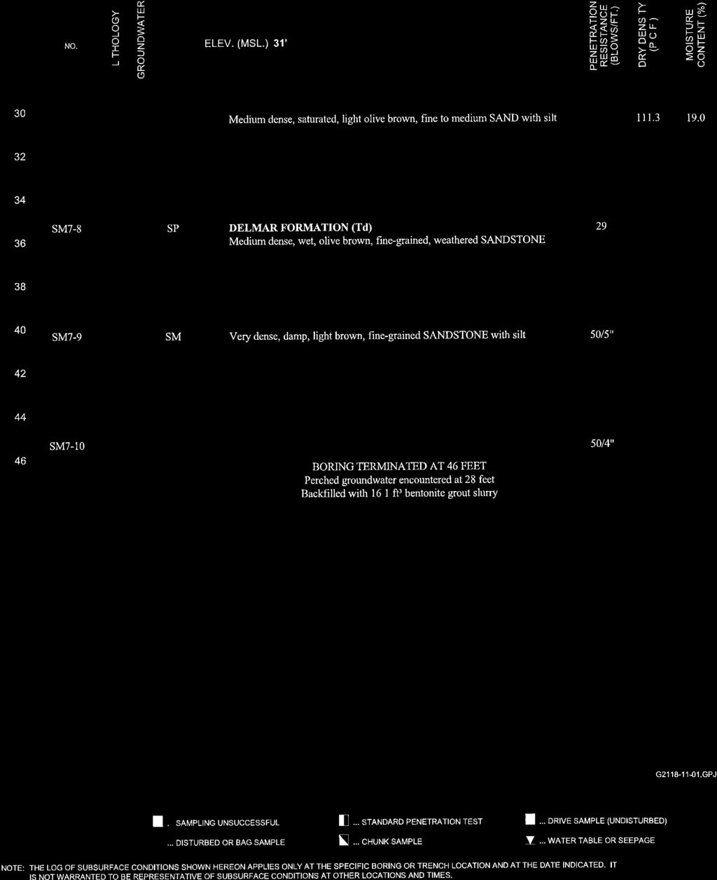
2 referenced Geocon (2017) report. As part of the currently proposed Via De La Valle widening project, which bounds the subject project site on the north, a geotechnical evaluation was prepared by Geocon (2017). For the roadway widening project, Geocon (2017) performed exploratory soil boring SM-7 at a location south of Via De La Valle, approximately 250 feet northeast of the proposed maintenance building location. Boring SM-7 extends through the surficial compacted fill soils and the underlying alluvial deposits and extends into materials referred to as the Delmar Formation. The subsurface soil information from this boring has been incorporated into our liquefaction analysis, and a copy of that boring log is presented in Attachment A. Generalized descriptions of the earth units encountered during the subsurface exploration for the original project geotechnical report (Ninyo & Moore, 2016) and the subsurface information encountered within boring SM-7 (Geocon, 2017) are provided in the subsequent sections. Additional descriptions of the subsurface units encountered within boring SM-7 (Geocon, 2017) are presented in Attachment A. Compacted Fill As described in our original project geotechnical report (Ninyo & Moore, 2016), compacted fill was encountered in our borings (B-1 through B-3) at the ground surface and extending to depths of up to approximately 6½ feet below the existing surface grades. The compacted fill materials generally consisted of brown and gray, moist, loose to dense, silty sand with gravel and cobbles, and silty gravel. Scattered concrete/construction debris was also encountered in the fill. As noted, we understand that the observation and testing of the previously placed compacted fill was performed by others (CTE, 2009) during grading of the site. Alluvium Alluvium was encountered in our borings B-1 through B-3 below the compacted fill soils and extended to the depths explored in the borings (Ninyo & Moore, 2016). Additionally, similar alluvial soils were also encountered in boring SM-7 underlying the compacted fill and extending to a depth of approximately 35 feet (Geocon, 2017). The alluvial materials encountered generally consisted of various shades of brown, moist to saturated, very loose to medium dense, silty sand and sand with silt. Ninyo & Moore San Dieguito River Park, San Diego, California October 31,
3 Delmar Formation As presented on the log for boring SM-7 (Geocon, 2017), materials of the Delmar Formation were encountered underlying the alluvium. As encountered, the Delmar Formation generally consisted of olive and light brown, damp to wet, medium dense to very dense, fine-grained sandstone and sandstone with silt. Groundwater During the subsurface exploration for the original project geotechnical report (Ninyo & Moore, 2016), groundwater at the proposed maintenance building site was encountered in our borings B-1 and B-2 at depths of approximately 17 and 15 ½ feet, respectively. These depths correspond to a groundwater elevation of approximately 7 feet above mean sea level (MSL). Fluctuations in the groundwater level and perched conditions may occur due to variations in ground surface topography, subsurface geologic conditions and structure, rainfall, irrigation, water elevation in the nearby lagoon, and other factors. Liquefaction and Seismically Induced Settlement Liquefaction is the phenomenon in which loosely deposited granular soils (with silt and clay contents of less than approximately 35 percent) and non-plastic silts located below the water table undergo rapid loss of shear strength when subjected to strong earthquake-induced ground shaking. Ground shaking of sufficient duration results in the loss of grain-to-grain contact due to a rapid rise in pore water pressure and causes the soil to behave as a fluid for a short period of time. Liquefaction is known generally to occur in saturated or near-saturated cohesionless soils at depths shallower than 50 feet below the ground surface. Factors known to influence liquefaction potential include composition and thickness of soil layers, grain size, relative density, groundwater level, degree of saturation, and both intensity and duration of ground shaking. Our subsurface exploration (Ninyo & Moore, 2016) and information provided on boring SM-7 (Geocon, 2017) indicates that the site is underlain by soils that are susceptible to liquefaction during a nearby seismic event. Accordingly, the liquefaction potential of subsurface soils was evaluated using the soil sampler blow counts recorded at various depths in our exploratory borings (B-1 through B-3), boring SM-7 (Geocon, 2017), and our laboratory test results. The liquefaction analysis was based on the National Center for Earthquake Engineering Research (NCEER) procedure (Youd, et al., 2001) developed from the methods originally recommended by Seed and Idriss (1982) using the computer program LiquefyPro (CivilTech Software, 2007). For purposes of our evaluation, groundwater was assumed to be at a depth of 7 feet above mean sea level (MSL). Ninyo & Moore San Dieguito River Park, San Diego, California October 31,
4 Our liquefaction analysis indicates that portions of the alluvial deposits encountered below the assumed groundwater level in the borings referenced for this analysis are generally susceptible to liquefaction during the design seismic event. The controlling magnitude for liquefaction analyses was a moment magnitude 6.9 that corresponds to the magnitude of a likely event on the nearby Rose Canyon fault zone (Del Mar Section) with a peak ground acceleration of 0.48g. Due to the very loose to medium dense nature of the alluvial deposits underlying the site and based on our evaluation and previous nearby evaluations, the potential for liquefaction is considered high up to a depth of approximately 35 feet below the ground surface. As a result of liquefaction, the proposed structure may be subject to several hazards, including liquefaction-induced settlement. In order to estimate the amount of post-earthquake settlement, the method proposed by Ishihara and Yoshimine (1992) was chosen for the evaluation of dynamic settlement. The amount of soil settlement during a strong seismic event depends on the thickness of the liquefiable layers and the density and/or consistency of the soils. Under the current conditions, post-earthquake total settlement of up to approximately 3 inches was calculated for the site using the computer project LiquefyPro (CivilTech Software, 2007). Lateral Spreading Lateral spread of the ground surface during an earthquake usually takes place along weak shear zones that have formed within a liquefiable soil layer. Lateral spread has generally been observed to take place in the direction of a free-face (i.e., retaining wall, slope, channel, etc.) but has also been observed to a lesser extent on ground surfaces with very gentle slopes. An empirical model developed by Youd et al. (2002) is typically used to predict the amount of horizontal ground displacement within a site. For sites located in proximity to a free-face, the amount of lateral ground displacement is correlated with the distance of the site from the free-face. Other factors such as earthquake magnitude, distance from the causative fault, thickness of the liquefiable layers, and the fines content and particle sizes of the liquefiable layers also influence the amount of lateral ground displacement. The project site gently slopes to the southeast. Our liquefaction analysis indicates that layers of alluvium and old paralic deposits with corrected standard penetration test (SPT) sampler blow counts of less than 15 (i.e., generally susceptible to seismically induced lateral spread) are present below the site. Based on the empirical model Youd and Bartlett (2002), we estimate that lateral spreading on the order of 1 foot or more may occur at the project location due to the sloping ground surface. It should be noted that due to the empirical nature of the Youd and Bartlett (2002) model, the lateral spread estimate should be considered as preliminary. The Youd and Bartlett (2002) model has a small displacement accuracy of no better than approximately 2 to 3 feet. Ninyo & Moore San Dieguito River Park, San Diego, California October 31,
5 FOUNDATIONS To mitigate the effects of potential liquefaction (including seismic settlement, lateral spreading, sand boils, etc.), we recommend that the proposed Maintenance Facility building be supported on a mat foundation system bearing on compacted fill materials prepared in accordance with the site preparation recommendations presented in our geotechnical evaluation (Ninyo & Moore, 2016). It is anticipated that liquefaction and resulting ground deformations will still occur. Ancillary structures such as site walls may be supported on conventional shallow continuous or spread footings bearing on at least 18 inches of recompacted fill materials. Foundations should be designed in accordance with structural considerations and the following recommendations. In addition, requirements of the appropriate governing jurisdictions and applicable building codes should be considered in the design of the structures. Other alternative measures to mitigate the effects of liquefaction of the existing fill soils may also be implemented. These alternative measures may include supporting the building on deep foundations that bear within the Delmar Formational materials and soil improvement that involves in-place densification of the fill soils at depth to reduce the soils susceptibility to liquefaction. If these or other alternative foundations systems/measures are desired, we can provide recommendations upon request. Be advised that as part of the foundation design election process, there is always a cost/benefit evaluation. Although we are providing recommendations for a specific building foundation system, we have not conducted the cost/benefit evaluation. Mat Foundations - Buildings An allowable bearing pressure of 2,000 pounds per square foot (psf) may be assumed for mat foundations constructed on the engineered fill recommended as part of the remedial grading. This allowable bearing capacity may be increased by one-third when considering loads of a short duration such as wind or seismic forces. Thickness and reinforcement of the mat foundation should be in accordance with the recommendations of the project structural engineer. Mat foundations typically experience some deflection due to loads placed on the mat and the reaction of the soils underlying the mat. A design coefficient of subgrade reaction, K v1, of 150 pounds per cubic inch may be used for evaluating such deflections at the subject site. This value is based on a unit square-foot area and should be adjusted for the planned mat size. The coefficient of subgrade reaction K b for a mat of specific width may be evaluated using the following equation: K b = K v1 [(b+1)/2b] 2 where b is the width of the foundation in feet. Ninyo & Moore San Dieguito River Park, San Diego, California October 31,
6
7 REFERENCES CivilTech Software, 2007, Liquefy Pro (Version 5.5j), A Computer Program for Liquefaction and Settlement Analysis. City of San Diego, 2017, Cycle Issues, Project , August 10. Construction Testing & Engineering, Inc. (CTE), 2009, Final Summary for Testing of Compacted Fill, San Dieguito Wetlands Restoration Project, San Diego and Del Mar, California: dated February 25. Geocon Incorporated, 2017, Geotechnical Investigation, Via de la Valle Street Widening, San Andreas Drive to El Camino Real, San Diego, California, August 30. Google, Inc., 2017, accessed in August. Ishihara, K. and Yoshimine, M., 1992, Evaluation of Settlements in Sand Deposits following Liquefaction during Earthquakes, Soils and Foundations, JSSMFE, Vol. 32, No. 1: dated March. Ninyo & Moore, In-House Proprietary Data. Ninyo & Moore, 2016, Geotechnical Evaluation, Proposed Maintenance Facility, San Dieguito River Park, San Diego, California, August 31. Seed, H.B., and Idriss, I.M., 1982, Ground Motions and Soil Liquefaction During Earthquakes, Earthquake Engineering Research Institute Monograph, Oakland, California, Tan, S.S. and Kennedy, M.P., 1996, Geologic Maps of the Northwestern Part of San Diego County, California; California Geological Survey, Open File Report Tokimatsu, K., and Seed, H.B., 1987, Evaluation of Settlements in Sands Due to Earthquake Shaking, Journal of Geotechnical Engineering, American Society of Civil Engineers, 113(8), Treiman, J.A., 1993, The Rose Canyon Fault Zone, Southern California: California Geological Survey, Open File Report Youd, T.L., Idriss, I.M., Andrus, R.D., Arango, I., Castro, G., Christian, J.T., Dobry, R., Finn, W.D., Harder, L.F., Hynes, M.E., Ishihara, K., Koester, J.P., Liao, S.S.C., Marcuson, W.F., Martin, G.R., Mitchell, J.K., Moriwaki, Y., Power, M.S., Robertson, P.K., Seed, R.B., and Stokoe, K.H., II., 2001, Liquefaction Resistance of Soils: Summary Report from the 1996 NCEER and 1998 NCEER/NSF Workshops on Evaluation of Liquefaction Resistance of Soils, Journal of Geotechnical and Geoenvironmental Engineering: American Society of Civil Engineering 124(10), pp Youd, T.L., Hansen, C.M., and Bartlett, S.F., 2002, Revised Multilinear Regression Equations for Prediction of Lateral Spread Displacement, Journal of Geotechnical and Geoenvironmental Engineer, Vol. 128, No. 12, ASCE: dated December 1. Ninyo & Moore San Dieguito River Park, San Diego, California October 31, 2017
8 FIGURE Ninyo & Moore San Dieguito River Park, San Diego, California October 31, 2017

9 VIA DE LA VALLE SM A' 30 Qcf Qal B-3 TD= B-2 TD= A B-1 TD= _ _BL_93.mxd AOB LEGEND A B-1 TD=16.5 PROPOSED BUILDING NOTE: DIRECTIONS, DIMENSIONS AND LOCATIONS ARE APPROXIMATE PROJECT NO. BORING TD=TOTAL DEPTH IN FEET SM-7 BORING (GEOCON, 2017) A' CROSS SECTION DATE /17 Qcf Qal 32 COMPACTED FILL OVER ALLUVIUM TOPOGRAPHY CONTOUR (RINEHART HERBST, 2015) FLOOD ZONE BORING LOCATIONS PROPOSED MAINTENANCE FACILITY SAN DIEGUITO RIVER PARK SAN DIEGO, CALIFORNIA SCALE IN FEET SOURCE: GOOGLE EARTH, RINEHART HERBST, FEMA, FIGURE 1
10 ATTACHMENT A Boring Logs (Ninyo & Moore, 2016 and Geocon, 2017) Ninyo & Moore San Dieguito River Park, San Diego, California October 31, 2017
11 DEPTH (feet) Bulk SAMPLES Driven BLOWS/FOOT MOISTURE (%) DRY DENSITY (PCF) SYMBOL CLASSIFICATION U.S.C.S. BORING LOG EXPLANATION SHEET 0 Bulk sample. Modified split-barrel drive sampler. 2-inch inner diameter split-barrel drive sampler. No recovery with modified split-barrel drive sampler, or 2-inch inner diameter split-barrel drive sampler. Sample retained by others. 5 Standard Penetration Test (SPT). No recovery with a SPT. XX/XX Shelby tube sample. Distance pushed in inches/length of sample recovered in inches. No recovery with Shelby tube sampler. 10 SM CL Continuous Push Sample. Seepage. Groundwater encountered during drilling. Groundwater measured after drilling. MAJOR MATERIAL TYPE (SOIL): Solid line denotes unit change. Dashed line denotes material change. 15 Attitudes: Strike/Dip b: Bedding c: Contact j: Joint f: Fracture F: Fault cs: Clay Seam s: Shear bss: Basal Slide Surface sf: Shear Fracture sz: Shear Zone sbs: Shear Bedding Surface The total depth line is a solid line that is drawn at the bottom of the boring. 20 BORING LOG Explanation of Boring Log Symbols PROJECT NO. DATE FIGURE
12 SOIL CLASSIFICATION CHART PER ASTM D 2488 SECONDARY DIVISIONS PRIMARY DIVISIONS GROUP SYMBOL GROUP NAME DESCRIPTION GRAIN SIZE SIEVE SIZE GRAIN SIZE APPROXIMATE SIZE CLEAN GRAVEL less than 5% fines GW GP well-graded GRAVEL poorly graded GRAVEL Boulders > 12 > 12 Larger than basketball-sized COARSE- GRAINED SOILS more than 50% retained on No. 200 sieve GRAVEL more than 50% of coarse fraction retained on No. 4 sieve SAND 50% or more of coarse fraction passes No. 4 sieve GRAVEL with DUAL CLASSIFICATIONS 5% to 12% fines GRAVEL with FINES more than 12% fines CLEAN SAND less than 5% fines SAND with DUAL CLASSIFICATIONS 5% to 12% fines SAND with FINES more than 12% fines GW-GM GP-GM GW-GC GP-GC GM GC GC-GM SW SP SW-SM SP-SM SW-SC SP-SC SM SC SC-SM well-graded GRAVEL with silt poorly graded GRAVEL with silt well-graded GRAVEL with clay poorly graded GRAVEL with clay silty GRAVEL clayey GRAVEL silty, clayey GRAVEL well-graded SAND poorly graded SAND well-graded SAND with silt poorly graded SAND with silt well-graded SAND with clay poorly graded SAND with clay silty SAND clayey SAND silty, clayey SAND Gravel Sand Cobbles Coarse 3/4-3 3/4-3 Fine #4-3/ Coarse #10 - # Medium #40 - # Fine #200 - # Fines Passing #200 < PLASTICITY CHART Fist-sized to basketball-sized Thumb-sized to fist-sized Pea-sized to thumb-sized Rock-salt-sized to pea-sized Sugar-sized to rock-salt-sized Flour-sized to sugar-sized Flour-sized and smaller FINE- GRAINED SOILS 50% or more passes No. 200 sieve SILT and CLAY liquid limit less than 50% SILT and CLAY liquid limit 50% or more INORGANIC ORGANIC INORGANIC ORGANIC CL ML CL-ML OL (PI > 4) OL (PI < 4) CH MH OH (plots on or above A -line) OH (plots below A -line) lean CLAY SILT silty CLAY organic CLAY organic SILT fat CLAY elastic SILT organic CLAY organic SILT Highly Organic Soils PT Peat PLASTICITY INDEX (PI), % CH or OH CL or OL MH or OH CL - ML ML or OL LIQUID LIMIT (LL), % APPARENT DENSITY APPARENT DENSITY - COARSE-GRAINED SOIL SPOOLING CABLE OR CATHEAD SPT (blows/foot) MODIFIED SPLIT BARREL (blows/foot) AUTOMATIC TRIP HAMMER SPT (blows/foot) MODIFIED SPLIT BARREL (blows/foot) Very Loose < 4 < 8 < 3 < 5 Loose Medium Dense Dense Very Dense > 50 > 105 > 33 > 70 CONSIS- TENCY CONSISTENCY - FINE-GRAINED SOIL SPOOLING CABLE OR CATHEAD SPT (blows/foot) MODIFIED SPLIT BARREL (blows/foot) AUTOMATIC TRIP HAMMER SPT (blows/foot) MODIFIED SPLIT BARREL (blows/foot) Very Soft < 2 < 3 < 1 < 2 Soft Firm Stiff Very Stiff Hard > 30 > 39 > 20 > 26 USCS METHOD OF SOIL CLASSIFICATION Explanation of USCS Method of Soil Classification PROJECT NO. DATE FIGURE
13 DEPTH (feet) 0 SAMPLES Bulk Driven BLOWS/FOOT MOISTURE (%) DRY DENSITY (PCF) SYMBOL CLASSIFICATION U.S.C.S. GM DATE DRILLED 7/21/16 BORING NO. B-1 GROUND ELEVATION 24' (MSL) SHEET 1 OF METHOD OF DRILLING 8" Diameter Hollow Stem Auger (Baja Exploration) (CME-75) DRIVE WEIGHT 140 lbs. (Auto-Trip) DROP 30" SAMPLED BY NMM LOGGED BY NMM REVIEWED BY TCS DESCRIPTION/INTERPRETATION FILL: Brown, moist, loose to medium dense, silty GRAVEL with sand SM ALLUVIUM: Grayish brown, moist, medium dense, silty fine SAND; trace gravel. Light brown to light reddish brown. Trace clay Greater moisture content Total Depth = 20 feet. Groundwater encountered at approximately 17.0 feet during drilling. Backfilled with approximately 6 cubic feet of bentonite shortly after drilling on 7/21/16. Note: Groundwater may rise to a level higher than that measured in borehole due to seasonal variations in precipitation and several other factors as discussed in the report. The ground elevation shown above is an estimation only. It is based on our interpretations of published maps and other documents reviewed for the purposes of this evaluation. It is not sufficiently accurate for preparing construction bids and design documents PROJECT NO BORING LOG PROPOSED MAINTENANCE FACILITY SAN DIEGUITO RIVER PARK, SAN DIEGO, CALIFORNIA DATE 8/16 FIGURE A-1
14 DEPTH (feet) 0 SAMPLES Bulk Driven BLOWS/FOOT MOISTURE (%) DRY DENSITY (PCF) SYMBOL CLASSIFICATION U.S.C.S. SM DATE DRILLED 7/21/16 BORING NO. B-2 GROUND ELEVATION 24' (MSL) SHEET 1 OF METHOD OF DRILLING 8" Diameter Hollow Stem Auger (Baja Exploration) (CME-75) DRIVE WEIGHT 140 lbs. (Auto-Trip) DROP 30" SAMPLED BY NMM LOGGED BY NMM REVIEWED BY TCS DESCRIPTION/INTERPRETATION FILL: Brown to grayish brown, moist, loose to medium dense, silty fine SAND; little gravel. 1 SM ALLUVIUM: Brown, moist, loose to medium dense, silty fine to medium SAND Medium dense Loose; trace clay. 9 Brown; medium dense; wet. Total Depth = 16.5 feet. Groundwater encountered at approximately 15.5 feet during drilling. Backfilled with approximately 5 cubic feet of bentonite shortly after drilling on 7/21/ Note: Groundwater may rise to a level higher than that measured in borehole due to seasonal variations in precipitation and several other factors as discussed in the report. The ground elevation shown above is an estimation only. It is based on our interpretations of published maps and other documents reviewed for the purposes of this evaluation. It is not sufficiently accurate for preparing construction bids and design documents BORING LOG PROPOSED MAINTENANCE FACILITY SAN DIEGUITO RIVER PARK, SAN DIEGO, CALIFORNIA PROJECT NO DATE 8/16 FIGURE A-2
15 DEPTH (feet) 0 SAMPLES Bulk Driven BLOWS/FOOT 50/2" MOISTURE (%) DRY DENSITY (PCF) SYMBOL CLASSIFICATION U.S.C.S. SM DATE DRILLED 7/20/16 BORING NO. B-3 GROUND ELEVATION 24' (MSL) SHEET 1 OF METHOD OF DRILLING 8" Diameter Hollow Stem Auger (Baja Exploration) (CME-75) DRIVE WEIGHT 140 lbs. (Auto-Trip) DROP 30" SAMPLED BY NMM LOGGED BY NMM REVIEWED BY TCS DESCRIPTION/INTERPRETATION FILL: Brown to grayish brown, moist, loose to medium dense, silty GRAVEL; some sand; trace cobbles up to approximately 7 inches in 2.5': Concrete piece approximately 6.5 inches in 3.5': Gray; trace travel and cobbles up to approximately 5 inches in 4.5': Brown SM ALLUVIUM: Reddish brown, moist, dense, silty fine to medium SAND. Total Depth = 7.2 feet. (Refusal) Groundwater encountered during drilling. Backfilled shortly after drilling on 7/20/16. Note: Groundwater may rise to a level higher than that measured in borehole due to seasonal variations in precipitation and several other factors as discussed in the report. The ground elevation shown above is an estimation only. It is based on our interpretations of published maps and other documents reviewed for the purposes of this evaluation. It is not sufficiently accurate for preparing construction bids and design documents BORING LOG PROPOSED MAINTENANCE FACILITY SAN DIEGUITO RIVER PARK, SAN DIEGO, CALIFORNIA PROJECT NO DATE 8/16 FIGURE A-3
16
17
 Photo 1 - Southerly view across 2700 parking lot toward existing building. Multi-residential building borders western side of property in upper right of view. Photo 2 - Southerly view across 2750 parking
 Project: ITHACA-TOMPKINS REGIONAL AIRPORT EXPANSION Project Location: ITHACA, NY Project Number: 218-34 Key to Soil Symbols and Terms TERMS DESCRIBING CONSISTENCY OR CONDITION COARSE-GRAINED SOILS (major
 SOIL CLASSIFICATION CHART COARSE-GRAINED SOILS MORE THAN 50% RETAINED ON NO.200 SIEVE FINE-GRAINED SOILS 50% OR MORE PASSES THE NO.200 SIEVE PRIMARY DIVISIONS GRAVELS MORE THAN 50% OF COARSE FRACTION RETAINED
B-1 BORE LOCATION PLAN. EXHIBIT Drawn By: 115G BROOKS VETERINARY CLINIC CITY BASE LANDING AND GOLIAD ROAD SAN ANTONIO, TEXAS.
 N B-1 SYMBOLS: Exploratory Boring Location Project Mngr: BORE LOCATION PLAN Project No. GK EXHIBIT Drawn By: 115G1063.02 GK Scale: Checked By: 1045 Central Parkway North, Suite 103 San Antonio, Texas 78232
Date: April 2, 2014 Project No.: Prepared For: Mr. Adam Kates CLASSIC COMMUNITIES 1068 E. Meadow Circle Palo Alto, California 94303
 City of Newark - 36120 Ruschin Drive Project Draft Initial Study/Mitigated Negative Declaration Appendix C: Geologic Information FirstCarbon Solutions H:\Client (PN-JN)\4554\45540001\ISMND\45540001 36120
December 5, Junction Gateway, LLC 7551 W. Sunset Boulevard #203 Los Angeles, CA Mr. James Frost P: Dear Mr.
 December 5, 2014 Junction Gateway, LLC 7551 W. Sunset Boulevard #203 90046 Attn: Re: Mr. James Frost P: 323.883.1800 Geotechnical Update Letter Sunset & Effie Mixed Use Development 4301 to 4311 Sunset
(THIS IS ONLY A SAMPLE REPORT OR APPENDIX OFFERED TO THE USERS OF THE COMPUTER PROGRAM
 C A U T I O N!! (THIS IS ONLY A SAMPLE REPORT OR APPENDIX OFFERED TO THE USERS OF THE COMPUTER PROGRAM EQLique&Settle2. THE AUTHOR IS HEREBY RELEASED OF ANY LIABILITY FOR ANY INCORRECT USE OF THIS SAMPLE
APPENDIX C HYDROGEOLOGIC INVESTIGATION
 Figure B-5.7 Figure B-5.8 Preliminary Geotechnical and Environmental Report Appendix C Hydrogeologic Investigation APPENDIX C HYDROGEOLOGIC INVESTIGATION December 21, 2011 WESTSIDE SUBWAY EXTENSION PROJECT
Depth (ft) USCS Soil Description TOPSOIL & FOREST DUFF
 USCS Soil Description TOPSOIL & FOREST DUFF") Test Pit No. TP-6 Location: Latitude 47.543003, Longitude -121.980441 Approximate Ground Surface Elevation: 1,132 feet Depth (ft) USCS Soil Description 0 1.5 1.5 5.0 SM 5.0 8.0 SM Loose to medium dense,
Test Pit No. TP-6 Location: Latitude 47.543003, Longitude -121.980441 Approximate Ground Surface Elevation: 1,132 feet Depth (ft) USCS Soil Description 0 1.5 1.5 5.0 SM 5.0 8.0 SM Loose to medium dense,
Pierce County Department of Planning and Land Services Development Engineering Section
 Page 1 of 7 Pierce County Department of Planning and Land Services Development Engineering Section PROJECT NAME: DATE: APPLICATION NO.: PCDE NO.: LANDSLIDE HAZARD AREA (LHA) GEOLOGICAL ASSESSMENT REPORT
Converse Consultants Geotechnical Engineering, Environmental & Groundwater Science, Inspection & Testing Services
 Converse Consultants Geotechnical Engineering, Environmental & Groundwater Science, Inspection & Testing Services Ms. Rebecca Mitchell Mt. San Antonio College Facilities Planning & Management 1100 North
Sensitivity of predicted liquefaction-induced lateral displacements from the 2010 Darfield and 2011 Christchurch Earthquakes
 Sensitivity of predicted liquefaction-induced lateral displacements from the 2010 Darfield and 2011 Christchurch Earthquakes K. Robinson, M. Cubrinovski, B.A. Bradley Department of Civil and Natural Resources
GEOTECHNICAL REPORT. Matanuska-Susitna Borough. Parks Highway Connections Museum Drive. Matanuska-Susitna Borough, Alaska.
 Matanuska-Susitna Borough GEOTECHNICAL REPORT Parks Highway Connections Museum Drive Matanuska-Susitna Borough, Alaska March 2, 20 Prepared By: John Thornley, PE Geotechnical Engineer 333 Arctic Blvd.,
Civil Engineering, Surveying and Environmental Consulting WASP0059.ltr.JLS.Mich Ave Bridge Geotech.docx
 2365 Haggerty Road South * Canton, Michigan 48188 P: 734-397-3100 * F: 734-397-3131 * www.manniksmithgroup.com August 29, 2012 Mr. Richard Kent Washtenaw County Parks and Recreation Commission 2330 Platt
APPENDIX A. Borehole Logs Explanation of Terms and Symbols
 APPENDIX A Borehole Logs Explanation of Terms and Symbols Page 153 of 168 EXPLANATION OF TERMS AND SYMBOLS The terms and symbols used on the borehole logs to summarize the results of field investigation
APPENDIX C. Borehole Data
 APPENDIX C Borehole Data MAJOR DIVISIONS SOIL CLASSIFICATION CHART SYMBOLS GRAPH LETTER TYPICAL DESCRIPTIONS ADDITIONAL MATERIAL
APPENDIX E SOILS TEST REPORTS
 Otsego County, NY Site Work Specifications APPENDIX E SOILS TEST REPORTS Blue Wing Services, Inc. July 1, 2010 Blue Wing Services May 20, 2010 Page 2 the site, was not made available to Empire at this
Liquefaction and Foundations
 Liquefaction and Foundations Amit Prashant Indian Institute of Technology Gandhinagar Short Course on Seismic Design of Reinforced Concrete Buildings 26 30 November, 2012 What is Liquefaction? Liquefaction
Mitigation of Liquefaction Potential Using Rammed Aggregate Piers
 ASCE 2011 557 Mitigation of Liquefaction Potential Using Rammed Aggregate Piers R.W. Rudolph, M. ASCE, G.E. 1, B. Serna, M. ASCE, P.E. 2, and T. Farrell, M. ASCE, G.E. 3 1 Principal Consultant, ENGEO,
Field Exploration. March 31, J-U-B ENGINEERS, Inc. 115 Northstar Avenue Twin Falls, Idaho Attn: Mr. Tracy Ahrens, P. E. E:
 March 31, 201 11 Northstar Avenue 83301 Attn: Mr. Tracy Ahrens, P. E. E: taa@jub.com Re: Geotechnical Data Report Preliminary Phase 1 Field Exploration Revision No. 1 Proposed Rapid Infiltration Basin
Clay Robinson, PhD, CPSS, PG copyright 2009
 Engineering: What's soil got to do with it? Clay Robinson, PhD, CPSS, PG crobinson@wtamu.edu, http://www.wtamu.edu/~crobinson, copyright 2009 Merriam-Webster Online Dictionary soil, noun 1 : firm land
Case History of Observed Liquefaction-Induced Settlement Versus Predicted Settlement
 Case History of Observed Liquefaction-Induced Settlement Versus Predicted Settlement M. Lew and L. Tran AMEC Environment & Infrastructure, Inc., Los Angeles, CA USA SUMMARY: A comparison of the predicted
New WW Hastings Hospital Geotechnical Investigation RFP Addendum #1
 88 E. Marshall Street, Suite 0 Tulsa, OK 76 98 8 9 Phone 98 8 798 FAX DATE: April 9, 0 ADDENDUM NO.: PROJECT: New WW Hastings Hospital BID PACKAGE NO: Geotechnical Investigation RFP SUBMITTED BY: CNCR
SUMMARY OF SOIL CONDITIONS CITYWIDE SIDEWALK IMPROVEMENT PROJECT JIMMY DURANTE BOULEVARD, VIA DE LA VALLE, AND CAMINO DEL MAR DEL MAR, CALIFORNIA
 SUMMARY OF SOIL CONDITIONS CITYWIDE SIDEWALK IMPROVEMENT PROJECT JIMMY DURANTE BOULEVARD, VIA DE LA VALLE, AND CAMINO DEL MAR DEL MAR, CALIFORNIA PREPARED FOR NASLAND ENGINEERING SAN DIEGO, CALIFORNIA
Geotechnical Data Report
 Geotechnical Data Report Downtown Greenville Future Conveyance Study December 1, 2015 Terracon Project No. 86155032 Prepared for: Prepared by: Terracon Consultants, Inc. December 1, 2015 561 Mauldin Road
ATTACHMENT A PRELIMINARY GEOTECHNICAL SUMMARY
 ATTACHMENT A PRELIMINARY GEOTECHNICAL SUMMARY Kevin M. Martin, P.E. KMM Geotechnical Consultants, LLC 7 Marshall Road Hampstead, NH 0384 603-489-6 (p)/ 603-489-8 (f)/78-78-4084(m) kevinmartinpe@aol.com
LATERAL CAPACITY OF PILES IN LIQUEFIABLE SOILS
 IGC 9, Guntur, INDIA LATERAL CAPACITY OF PILES IN LIQUEFIABLE SOILS A.S. Kiran M. Tech. (Geotech), Dept. of Civil Engineering, IIT Roorkee, Roorkee 77, India. E-mail: kiran.nta@gmail.com G. Ramasamy Professor,
Appendix G GEOLOGICAL INVESTIGATION
 Appendix G GEOLOGICAL INVESTIGATION JOB NUMBER: 3268.001 DATE: 10-14-13 BY: CC SITE 0 2000 1"=2000' VICINITY MAP CARGILL PARCEL HICKORY STREET AND ENTERPRISE DRIVE NEWARK, CALIFORNIA FOR
Address for Correspondence
 Research Paper DYNAMIC ANALYSIS OF KASWATI EARTH DAM 1 Patel Samir K., 2 Prof. C.S.Sanghavi Address for Correspondence 1 Applied Mechanics Department, 2 Professor, L. D. College of Engineering, Gujarat
Investigation of Liquefaction Failure in Earthen Dams during Bhuj Earthquake
 Investigation of Liquefaction Failure in Earthen Dams during Bhuj Earthquake Raghvendra Singh QIP Scholar, Department of Civil Engineering, Indian Institute of Technology, Kharagpur 721302, WB. Email:
DATA REPORT GEOTECHNICAL INVESTIGATION GALVESTON CRUISE TERMINAL 2 GALVESTON, TEXAS
 DATA REPORT GEOTECHNICAL INVESTIGATION GALVESTON CRUISE TERMINAL 2 GALVESTON, TEXAS SUBMITTED TO PORT OF GALVESTON 123 ROSENBERG AVENUE, 8TH FLOOR GALVESTON, TEXAS 77553 BY HVJ ASSOCIATES, INC. HOUSTON,
ADDENDUM 1 FISHER SLOUGH RESTORATION PROJECT SKAGIT COUNTY, WASHINGTON
 F I N A L A D D E N D U M 1 R E P O R T ADDENDUM 1 FISHER SLOUGH RESTORATION PROJECT SKAGIT COUNTY, WASHINGTON REPORT OF GEOTECHNICAL INVESTIGATION URS JOB NO. 3376186 Prepared for Tetra Tech Inc. 142
CITY OF VALDEZ Project Title: East Pioneer Reconstruction Project No.: Contract No.: TO: All Recipients Date: April 14, 2014
 CITY OF VALDEZ Project Title: East Pioneer Reconstruction Project No.: 13-3-1.32 Contract No.: 11 TO: All Recipients Date: April 14, 214 SUBJECT: Addendum No.1 This seventeen (17) page Addendum forms a
 R-1 Conveyor Relocation Project Legend 0 500 1000 1500 ft. This map is a user generated static output from an Internet mapping site and is for general reference only. Data layers that appear on this map
Boreholes. Implementation. Boring. Boreholes may be excavated by one of these methods: 1. Auger Boring 2. Wash Boring 3.
 Implementation Boreholes 1. Auger Boring 2. Wash Boring 3. Rotary Drilling Boring Boreholes may be excavated by one of these methods: 4. Percussion Drilling The right choice of method depends on: Ground
Geotechnical Data Report
 Geotechnical Data Report ReWa Solar Farm at Durbin Creek Fountain Inn, South Carolina September 1, 2017 Terracon Project No. 86165043 Prepared for: Renewable Water Resources Greenville, South Carolina
Evaluation of Geotechnical Hazards
 Evaluation of Geotechnical Hazards by Geoffrey R. Martin Appendix B: Evaluation of Geotechnical Hazards Describes Evaluation Procedures Soil Liquefaction Soil Settlement Surface Fault Rupture Flooding
Sensitivity of predicted liquefaction-induced lateral spreading displacements from the 2010 Darfield and 2011 Christchurch earthquakes
 Robinson, K., Cubrinovski, M. & Bradley, B.A. (2013) and 2011 Christchurch earthquakes Proc. 19 th NZGS Geotechnical Symposium. Ed. CY Chin, Queenstown Sensitivity of predicted liquefaction-induced lateral
Solution:Example 1. Example 2. Solution: Example 2. clay. Textural Soil Classification System (USDA) CE353 Soil Mechanics Dr.
 CE353 Soil Mechanics Dr.") CE353 Soil Mechanics CE353 Lecture 5 Geotechnical Engineering Laboratory SOIL CLASSIFICATION Lecture 5 SOIL CLASSIFICATION Dr. Talat A Bader Dr. Talat Bader 2 Requirements of a soil Systems Why do we need
CE353 Soil Mechanics CE353 Lecture 5 Geotechnical Engineering Laboratory SOIL CLASSIFICATION Lecture 5 SOIL CLASSIFICATION Dr. Talat A Bader Dr. Talat Bader 2 Requirements of a soil Systems Why do we need
CE 240 Soil Mechanics & Foundations Lecture 3.2. Engineering Classification of Soil (AASHTO and USCS) (Das, Ch. 4)
 (Das, Ch. 4)") CE 240 Soil Mechanics & Foundations Lecture 3.2 Engineering Classification of Soil (AASHTO and USCS) (Das, Ch. 4) Outline of this Lecture 1. Particle distribution and Atterberg Limits 2. Soil classification
CE 240 Soil Mechanics & Foundations Lecture 3.2 Engineering Classification of Soil (AASHTO and USCS) (Das, Ch. 4) Outline of this Lecture 1. Particle distribution and Atterberg Limits 2. Soil classification
Limited Geotechnical Engineering Evaluation Classroom Additions Albany County Campus Laramie, Wyoming
 Limited Geotechnical Engineering Evaluation Classroom Additions Albany County Campus 2300 Missile Drive, Cheyenne, Wyoming 82001 Phone 307-635-0222 www.stratageotech.com Limited Geotechnical Engineering
Geotechnical Evaluation
 Geotechnical Evaluation Horseshoe Bend Trail Improvements Horseshoe Bend Trail Page, Arizona Weddle Gilmore 6916 East Fifth Avenue Scottsdale, Arizona 85251 September 5, 2018 Project No. 605379001 Geotechnical
IV. ENVIRONMENTAL IMPACT ANALYSIS G. GEOLOGY AND SOILS
 IV. ENVIRONMENTAL IMPACT ANALYSIS G. GEOLOGY AND SOILS The following section is a summary of the geotechnical report conducted for the proposed project. The Report of Geotechnical Investigation Proposed
Use of Numerical Simulation in the Development of Empirical Predictions of Liquefaction Behavior
 Use of Numerical Simulation in the Development of Empirical Predictions of Liquefaction Behavior Steven L. Kramer and David A. Baska University of Washington ABSTRACT Soil liquefaction has been an interesting
3.0 SUMMARY OF FINDINGS
 AECOM 500 W Jefferson St. Suite 1600 Louisville, KY 40202 www.aecom.com 502-569-2301 tel 502-569-2304 fax October 17, 2018 Big Rivers Electric Corporation Sebree Generating Station 9000 Highway 2096 Robards,
APPENDIX A GEOTECHNICAL REPORT
 The City of Winnipeg Bid Opportunity No. 529-2017 Template Version: C420170317 - RW APPENDIX A GEOTECHNICAL REPORT Quality Engineering Valued Relationships KGS Group 2017 Industrial Street Rehabilitation
Preliminary Geotechnical Investigation Cadiz / Trigg County I-24 Business Park. Cadiz, Kentucky
 Environmental & Geoscience, LLC 834 Madisonville Road Hopkinsville, KY 440 70.44.000 FAX 70.44.8300 www.wedrill.com A member of Trinity Energy & Infrastructure Group, LLC Preliminary Geotechnical Investigation
 TP-1 N61E 0 DARK BROWN SANDY SILT (ML) stiff, wet with roots (Disturbed Surficial Soil) DEPTH (FEET) 5 REDDISH BROWN SANDSTONE intensely fractured, weak to friable, deeply weathered, tight (Franciscan
B-1 SURFACE ELEVATION
 5A 5B LOGGED BY El. S. Bhangoo DRILLING CONTRACTOR Pitcher Drilling DRILLING METHOD Rotary Wash BEGIN DATE 12-14-12 SAMPLER TYPE(S) AND SIZE(S) (ID) SPT, MC BOREHOLE BACKFILL AND COMPLETION COMPLETION
Chapter 12 Subsurface Exploration
 Page 12 1 Chapter 12 Subsurface Exploration 1. The process of identifying the layers of deposits that underlie a proposed structure and their physical characteristics is generally referred to as (a) subsurface
 FIGURES 200 200 200 SW 175TH AVE 350 SW SCHOLLS FERRY RD SW FRIENDLY LN Area 64 SW ROY ROGERS RD 300 250 SW ONEILL CT SW LUKE LN SW LEEDING LN SW TUSCANY ST SW 164TH AVE SW BULL MOUNTAIN RD SW 164TH AVE
Determination of Liquefaction Potential By Sub-Surface Exploration Using Standard Penetration Test
 Determination of Liquefaction Potential By Sub-Surface Exploration Using Standard Penetration Test 1 Sabih Ahmad, 2 M.Z.Khan, 3 Abdullah Anwar and 4 Syed Mohd. Ashraf Husain 1 Associate Professor and Head,
IN SITU SPECIFIC GRAVITY VS GRAIN SIZE: A BETTER METHOD TO ESTIMATE NEW WORK DREDGING PRODUCTION
 IN SITU SPECIFIC GRAVITY VS GRAIN SIZE: A BETTER METHOD TO ESTIMATE NEW WORK DREDGING PRODUCTION Nancy Case O Bourke, PE 1, Gregory L. Hartman, PE 2 and Paul Fuglevand, PE 3 ABSTRACT In-situ specific gravity
Geotechnical Engineering Study, Conifer Senior High School Football Field Improvements, Conifer, Colorado
 2390 South Lipan Street Denver, CO 80223 phone: (303) 742-9700 fax: (303) 742-9666 email: kadenver@kumarusa.com www.kumarusa.com Office Locations: Denver (HQ), Colorado Springs, Fort Collins, and Frisco,
Liquefaction: Additional issues. This presentation consists of two parts: Section 1
 Liquefaction: Additional issues Ahmed Elgamal This presentation consists of two parts: Section 1 Liquefaction of fine grained soils and cyclic softening in silts and clays Section 2 Empirical relationship
Increase in Cyclic Liquefaction Resistance of Sandy Soil Due to Installation of Drilled Displacement Piles
 Presented at the Earthquake Engineering and Soil Dynamics IV Conference, Sacramento CA Increase in Cyclic Liquefaction Resistance of Sandy Soil Due to Installation of Drilled Displacement Piles Timothy
ENCE 3610 Soil Mechanics. Site Exploration and Characterisation Field Exploration Methods
 ENCE 3610 Soil Mechanics Site Exploration and Characterisation Field Exploration Methods Geotechnical Involvement in Project Phases Planning Design Alternatives Preparation of Detailed Plans Final Design
Safe bearing capacity evaluation of the bridge site along Syafrubesi-Rasuwagadhi road, Central Nepal
 Bulletin of the Department of Geology Bulletin of the Department of Geology, Tribhuvan University, Kathmandu, Nepal, Vol. 12, 2009, pp. 95 100 Safe bearing capacity evaluation of the bridge site along
Geotechnical Engineering Report
 Geotechnical Engineering Report Turner Turnpike Widening Bridge B Bridge Crossing: South 257 th West Avenue Creek County, Oklahoma June 1, 2016 Terracon Project No. 04155197 Prepared for: Garver, LLC Tulsa,
Geotechnical Engineering Report
 Geotechnical Engineering Report Turner Turnpike Widening Polecat Creek Bridge (Bridge A) June 1, 2016 Terracon Project No. 04155197 Prepared for: Garver, LLC Prepared by: Terracon Consultants, Inc. TABLE
A POST-LIQUEFACTION STUDY AFTER THE 2014 CHIANG RAI EARTHQUAKE IN THAILAND
 Geotec., Const. Mat. & Env., DOI: https://doi.org/10.21660/2018.46.7261 ISSN: 2186-2982 (Print), 2186-2990 (Online), Japan A POST-LIQUEFACTION STUDY AFTER THE 2014 CHIANG RAI EARTHQUAKE IN THAILAND *Sethapong
ENGINEERING ASSOCIATES
 July 16, 211 Vista Design, Inc. 11634 Worcester Highway Showell, Maryland 21862 Attention: Reference: Dear Mr. Polk: Mr. Richard F. Polk, P.E. Geotechnical Engineering Report Charles County RFP No. 11-9
CITY OF CAPE CORAL NORTH 2 UTILITIES EXTENSION PROJECT CONTRACT 3
 GEOTECHNICAL REPORT CITY OF CAPE CORAL NORTH UTILITIES EXTENSION PROJECT CONTRACT City of Cape Coral Procurement Division Cultural Park Boulevard, nd Floor Cape Coral, FL ISSUED FOR BID VOLUME of GEOTECHNICAL
Geotechnical Investigation Juneau Seawalk - Taku Fisheries to Miner s Wharf Juneau, Alaska DM&A Job No
 Duane Miller & Associates 5821 Arctic Boulevard, Suite A Anchorage, AK 99518-1654 (907) 644-3200 Fax 644-0507 Arctic & Geotechnical Engineering May 4, 2006 Tetra Tech/KCM, Inc. 1971 First Avenue Seattle,
SOME OBSERVATIONS RELATED TO LIQUEFACTION SUSCEPTIBILITY OF SILTY SOILS
 SOME OBSERVATIONS RELATED TO LIQUEFACTION SUSCEPTIBILITY OF SILTY SOILS Upul ATUKORALA 1, Dharma WIJEWICKREME 2 And Norman MCCAMMON 3 SUMMARY The liquefaction susceptibility of silty soils has not received
Appendix B: Geotechnical Report
 Appendix B: Geotechnical Report August 24, 2016 Mr. Brad Perozzi Branch West 5000 Birch Suite 600 East Tower Newport Beach, California 92660 Subject: Geotechnical Due-Diligence Investigation, Proposed
Module 8 SEISMIC SLOPE STABILITY (Lectures 37 to 40)
") Lecture 40 Topics Module 8 SEISMIC SLOPE STABILITY Lectures 37 to 40) 8.6.15 Analysis of Weakening Instability 8.6.16 Flow Failure Analysis 8.6.17 Analysis of Stability 8.6.18 Analysis of Deformation 8.6.19
Lecture 40 Topics Module 8 SEISMIC SLOPE STABILITY Lectures 37 to 40) 8.6.15 Analysis of Weakening Instability 8.6.16 Flow Failure Analysis 8.6.17 Analysis of Stability 8.6.18 Analysis of Deformation 8.6.19
DRILL HOLE # BH-BGC13-FN-01
 DILL HOLE # BH-BGC3-FN-0 Drill Method: Mud otary/coring Depth To ock (m): N/A Page of 7 eviewed by: AJB 0 GAVEL (GW) Fine to coarse, sandy, well graded, dense, max particle size = 30 mm, angular to subrounded,
A CASE STUDY OF LIQUEFACTION ASSESSMENT USING SWEDISH WEIGHT SOUNDING
 4th International Conference on Earthquake Engineering Taipei, Taiwan October 12-13, 2006 Paper No. 038 A CASE STUDY OF LIQUEFACTION ASSESSMENT USING SWEDISH WEIGHT SOUNDING Mahdi Habibi 1, Akbar Cheshomi
Dashed line indicates the approximate upper limit boundary for natural soils. C L o r O L C H o r O H
 SYMBOL SOURCE 8 9 1 SOIL DATA NATURAL SAMPLE DEPTH WATER PLASTIC LIQUID PLASTICITY NO. CONTENT LIMIT LIMIT INDEX (%) (%) (%) (%) Client: County of Berthoud Project: Project No.: Boring B-2 S-1-5' 6.2 8
Short Review on Liquefaction Susceptibility
 Short Review on Liquefaction Susceptibility Aminaton Marto*, Tan Choy Soon** *Professor, Faculty of Civil Engineering, Universiti Teknologi Malaysi, Skudai, Johor, Malaysia ** PhD Candidate, Faculty of
Liquefaction induced ground damage in the Canterbury earthquakes: predictions vs. reality
 Bowen, H. J. & Jacka, M. E. () Proc. th NZGS Geotechnical Symposium. Ed. CY Chin, Queenstown Liquefaction induced ground damage in the Canterbury earthquakes: predictions vs. reality H J Bowen & M E Jacka
Evaluation of the Liquefaction Potential by In-situ Tests and Laboratory Experiments In Complex Geological Conditions
 Evaluation of the Liquefaction Potential by In-situ Tests and Laboratory Experiments In Complex Geological Conditions V. Sesov, K. Edip & J. Cvetanovska University Ss. Cyril and Methodius, Institute of
Impact : Changes to Existing Topography (Less than Significant)
") 4.2 Land Resources 4.2.1 Alternative A Proposed Action Impact 4.2.1-1: Changes to Existing Topography (Less than Significant) Development of the project site would involve grading and other earthwork as
4.2 Land Resources 4.2.1 Alternative A Proposed Action Impact 4.2.1-1: Changes to Existing Topography (Less than Significant) Development of the project site would involve grading and other earthwork as
PRELIMINARY GEOTECHNICAL REPORT. State College Redevelopment State College Borough, Centre County, Pennsylvania. CMT Laboratories File No.
 PRELIMINARY GEOTECHNICAL REPORT State College Redevelopment State College Borough, Centre County, Pennsylvania CMT Laboratories File No. 1638700 Prepared for: National Development Council One Battery Park
September 7, 2017 (Revised November 1, 2017)
") September 7, 2017 (Revised November 1, 2017) Project No. 10113.002 Environmental Advisors 2400 East Katella Avenue, Suite 800 Anaheim, California 92806 Attention: Subject: Mr. Greg McCafferty Response
September 7, 2017 (Revised November 1, 2017) Project No. 10113.002 Environmental Advisors 2400 East Katella Avenue, Suite 800 Anaheim, California 92806 Attention: Subject: Mr. Greg McCafferty Response
Soil Mechanics Brief Review. Presented by: Gary L. Seider, P.E.
 Soil Mechanics Brief Review Presented by: Gary L. Seider, P.E. 1 BASIC ROCK TYPES Igneous Rock (e.g. granite, basalt) Rock formed in place by cooling from magma Generally very stiff/strong and often abrasive
June 9, R. D. Cook, P.Eng. Soils Engineer Special Services Western Region PUBLIC WORKS CANADA WESTERN REGION REPORT ON
 PUBLIC WORKS CANADA WESTERN REGION REPORT ON GEOTECHNICAL INVESTIGATION PROPOSED MARTIN RIVER BRIDGE MILE 306.7 MACKENZIE HIGHWAY Submitted by : R. D. Cook, P.Eng. Soils Engineer Special Services Western
UAS Student Residence
 General Notes, Abbreviations and Symbols C100 MATCH LINE - SEE SHEET L6 Existing Site Topographic Conditions C101 MATCH LINE - SEE SHEET L5 Existing Site Topographic Conditions C102 DEPTH(FT.) 5 FROZEN
Preliminary Geotechnical Evaluation Gooseberry Point Pedestrian Improvements Whatcom County, Washington SITE AND PROJECT DESCRIPTION
 File No. 12-100 Geotechnical & Earthquake Engineering Consultants Mr. Kevin Brown, P.E. Gray & Osborne, Inc. 3710 168 th Street NE, Suite B210 Arlington, Washington 98223 Subject: Draft Report Preliminary
Ardaman & Associates, Inc. Geotechnical, Environmental and Materials Consultants
 SUBSURFACE SOIL EXPLORATION 42-INCH FORCE MAIN REPLACEMENT CHIQUITA BOULEVARD S AND SW 34 TH STREET CAPE CORAL, LEE COUNTY, FLORIDA Ardaman & Associates, Inc. Geotechnical, Environmental and Materials
SUPPLEMENTARY INVESTIGATION AND LABORATORY TESTING Aggregate Resource Evaluation Proposed Bernand Quarry San Diego County, California
 October 3, 2 Mr. Mark San Agustin Project No. 28-- Home Land Investments Document No. -92 2239 Curlew Street San Diego, CA 92 SUBJECT: SUPPLEMENTARY INVESTIGATION AND LABORATORY TESTING Aggregate Resource
A comparison between two field methods of evaluation of liquefaction potential in the Bandar Abbas City
 American Journal of Civil Engineering 2015; 3(2-2): 1-5 Published online January 16, 2015 (http://www.sciencepublishinggroup.com/j/ajce) doi: 10.11648/j.ajce.s.2015030202.11 ISSN: 2330-8729 (Print); ISSN:
Liquefaction. Ajanta Sachan. Assistant Professor Civil Engineering IIT Gandhinagar. Why does the Liquefaction occur?
 Liquefaction Ajanta Sachan Assistant Professor Civil Engineering IIT Gandhinagar Liquefaction What is Liquefaction? Why does the Liquefaction occur? When has Liquefaction occurred in the past? Where does
February 16, 2015 File No Ms. Robin Yates TRC Engineers Inc N. Fresno Street, Suite 200 Fresno, California 93710
 February 16, 2015 File No. 20152738 Ms. Robin Yates TRC Engineers Inc. 6051 N. Fresno Street, Suite 200 Fresno, California 93710 SUBJECT: Geotechnical Design Memorandum Fresno BPMP Scour Countermeasure
EARTHQUAKE-INDUCED SETTLEMENTS IN SATURATED SANDY SOILS
 VOL., NO., AUGUST 7 ISSN 119- -7 Asian Research Publishing Network (ARPN). All rights reserved. EARTHQUAKE-INDUCED SETTLEMENTS IN SATURATED SANDY SOILS C. Y. Lee Department of Civil Engineering, College
Comparison of Three Procedures for Evaluating Earthquake-Induced Soil Liquefaction
 Missouri University of Science and Technology Scholars' Mine International Conferences on Recent Advances in Geotechnical Earthquake Engineering and Soil Dynamics 2010 - Fifth International Conference
Northern Colorado Geotech
 PRELIMINARY GEOTECHNICAL ENGINEERING REPORT PROPOSED CECIL FARMS DEVELOPMENT WELD COUNTY ROAD 7, BETWEEN ROADS 7 AND 7 SEVERANCE, COLORADO NORTHERN COLORADO GEOTECH PROJECT NO. 0-6 APRIL 0, 06 Prepared
Soil Dynamics Prof. Deepankar Choudhury Department of Civil Engineering Indian Institute of Technology, Bombay
 Soil Dynamics Prof. Deepankar Choudhury Department of Civil Engineering Indian Institute of Technology, Bombay Module - 4 Dynamic Soil Properties Lecture - 23 Cyclic Stress Ratio, Evaluation of CRR, Correction
Project No: 68R3056 Client: City of Frederick Project: RFQ 14-H Future North Side Water Tank City/State: 7516 Hayward Road, Frederick, MD
 Boring: SB-1 (1 of 1) Moist, brown to orange brown CLAY and SILT, trace sand with fine weathered rock fragments. POSSIBLE FILL. Dry, orange brown sandy SILT trace clay (SM-ML). RESIDUAL SOIL : Not Surveyed
Report of Preliminary Geotechnical Exploration. CSO-012 Sewer Separation Cincinnati, Hamilton County, Ohio. February, 2011
 11242843_GeoTech_Preliminary - Feburary 2011_1/40 Report of Preliminary Geotechnical Exploration CSO-012 Sewer Separation Cincinnati, Hamilton County, Ohio February, 2011 11242843_GeoTech_Preliminary -
Parsons APPENDIX A BORING LOGS AND DEVELOPMENT LOG
 Parsons APPENDIX A BORING LOGS AND DEVELOPMENT LOG GEOLOGIC LOG DATE STARTED: DATE COMPLETED: 08-Sep-09 08-Sep-09 LOGGER: Quin Kinnebrew WEATHER: Clear & Warm PAGE 1 OF 2 WELL NO. GMW-66 COMPANY NAME:
Comparison of different methods for evaluating the liquefaction potential of sandy soils in Bandar Abbas
 Comparison of different methods for evaluating the liquefaction potential of sandy soils in Bandar Abbas M. Mosaffa¹ & M. Rafiee² 1.Geotechnical M.S. student Hormozgan University, Bandar Abbas, Iran(Email:Amestris@gmail.com).Geotechnical
M E M O R A N D U M. Mr. Jonathan K. Thrasher, P.E., Mr. Ian Kinnear, P.E. (FL) PSI
 PSI") M E M O R A N D U M TO: FROM: Mr. Mark Schilling Gulf Interstate Engineering Mr. Jonathan K. Thrasher, P.E., Mr. Ian Kinnear, P.E. (FL) PSI DATE: November 11, 2014 RE: Summary of Findings Geotechnical
M E M O R A N D U M TO: FROM: Mr. Mark Schilling Gulf Interstate Engineering Mr. Jonathan K. Thrasher, P.E., Mr. Ian Kinnear, P.E. (FL) PSI DATE: November 11, 2014 RE: Summary of Findings Geotechnical
REPORT OF SUBSURFACE EXPLORATION
 REPORT OF SUBSURFACE EXPLORATION GRAND RIVER DAM AUTHORITY HULBERT 69 KV SWITCHING STATION S. 440 Road Hulbert, Cherokee County, Oklahoma ENERCON PROJECT NO. GRDA006 MARCH 7, 2012 PREPARED FOR: C/O ENERCON
PRELIMINARY GEOTECHNICAL ENGINEERING REPORT
 PRELIMINARY GEOTECHNICAL ENGINEERING REPORT TOWN OF ASHLAND TOWN HALL 101 THOMPSON STREET ASHLAND, VIRGINIA JOB NUMBER: 39016 PREPARED FOR: PMA PLANNERS & ARCHITECTS 10325 WARWICK BOULEVARD NEWPORT NEWS,
 UNIT DESCRIPTIONS: Artificial Fill, Undocumented (Afu): Locally derived sandy silt and silty sand, locally with clay and varying amounts of gravel and man-made debris. Abundant concrete rubble, in places
Liquefaction Evaluation
 Liquefaction Evaluation Ahmed Elgamal and Zhaohui Yang University of California, San Diego Acknowledgements The Liquefaction Evaluation section is prepared mainly following: Kramer, S. L. (1996). Geotechnical
REPORT OF PRELIMINARY GEOTECHNICAL EXPLORATION
 REPORT OF PRELIMINARY GEOTECHNICAL EXPLORATION ENKA INTERMEDIATE SCHOOL Sand Hill Road Candler, North Carolina Prepared For: BUNCOMBE COUNTY SCHOOLS Prepared By: AMEC ENVIRONMENT & INFRASTRUCTURE, INC.
General. DATE December 10, 2013 PROJECT No TO Mary Jarvis Urbandale/Riverside South Development Corporation
 DATE December 10, 201 PROJECT No. 10-1121-0260- TO Mary Jarvis Urbandale/Riverside South Development Corporation CC Justin Robitaille, Urbandale Jonathan Párraga, J.L. Richards & Associates Limited FROM