West Washmawapta Glacier
|
|
|
- Curtis Stokes
- 5 years ago
- Views:
Transcription


1


2 We emplaced the geophones on the rockwall just above the lip of the glacier, about 5 m apart (Figure 1). Each was epoxied to a flat surface and covered with small rocks to protect it from falling debris. The system ran intermittently over a 5 week period from 5-Aug- to 7-Sep-. The irregular operation was caused by overheating failure of a solar controller. The system recorded a total of 1 hours of seismic data. 3 RESULTS 3.1 Calibration Data Several times during the study period we were able to spend a few hours near the seismic system observing and annotating rockfall activity in the vicinity of the geophones. These observations and simultaneous seismic data allowed us to determine the seismic signature of known events and provided crucial calibration for future observations. From this calibration data we were then able to create detection criteria to identify rockfall events in other data sets. In general, there were two types of rockfall events: single block fall and surficial talus slide. Single block falls originated high on the rockwall and struck the cliff a number of times during their descent to the glacier. Block size averaged about.3 m, and a typical fall lasted from 3-1 seconds with about 5-1 audible impacts before landing on the soft snow of the upper glacier. The seismic signature of a single block fall was characterized by a long disturbance made up of multiple high-frequency spikes (Figure ). Our Hz system probably under-sampled this high-frequency signal. Single block fall disturbances attenuated rapidly with distance along the rockwall; commonly a small block falling near geophone #1 was not detected ~5 m away by geophone #. The talus slides observed at our field site usually originated near geophone #, where a talus slope is underlain by stagnant glacial ice. As this ice melted throughout the day, the talus above it shifted and reorganized. Typically, a talus slide encompassed an area of about 1 m. These types of events were frequent and generally the length of each slide was only a few meters. The seismic response of a talus slide was characterized by a more continuous release of energy compared to the episodic trace of block falls. The signal was emergent, then decayed over a typical slide time of ~1 seconds (Figure 3). N # #1 Base Helmet Mountain West Washmawapta Glacier British Columbia Figure 1. Overview of the study area at Helmet Mountain, British Columbia. The West Washmawapta glacier (seen draining northeast) undercuts the large headwall of Helmet Mountain where heavily jointed meta-sedimentary rocks are prone to degradation by rockfall. Two geophones were emplaced on the rockwall, separated by about 5 m, as shown in the inset figure. The star at the toe of the glacier shows the location of the weather station. (Image: DigitalGlobe)
.")

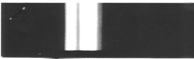
3 Figure. Characteristic high-frequency seismic response during a single block fall (geophone #1). In this particular event a block with an intermediate axis of ~.3 m tumbled down the cliff face some 3 m, striking the wall a number of times en route. These data, as in Figure 3, are unfiltered. Figure 3. A typical emergent seismic response during a small talus slide (geophone #). Events like these were common in an area near geophone # where talus overlays stagnant glacial ice. As the ice melts throughout the day, the talus above shifts and reorganizes. Typical slide lengths were on the order of 1 m. The vertical scale is the same as in Figure. Rockfall events were monitored by an observer over a few hours on several days, notably six hours on 7-Aug-. In general there was a good match between personal and seismic observations of rockfall and talus reorganization. Nevertheless, there were a few events in the seismic record that were not identified by the field observer. These may be caused by more distant rockfall on the opposite side of the slope, or possibly ice calving at the toe of the glacier (which happened frequently). From the calibration data we were able to create event detection criteria to identify rockfall in the longer records of August 5-9 and September 1-7. The criteria are based on the amplitude, duration, and shape of the seismic disturbance. The amplitude must clearly exceed the background noise level, which was variable. The disturbance must persist for several seconds, to distinguish real data from intermittent electronic noise. The form of the response must match the appearance of known types of rockfall events, as illustrated in Figures and Record of Rockfall In this work we analyze the seismic record from 1-Sep- at 1:h to 7-Sep- at :h, a span of 13 hours. This data set is fairly continuous with a few notable exceptions: the system was not operational on 5-Sep- or on the morning of -Sep-, while in the early morning hours of -Sep- and 7-Sep- the seismic records were too noisy to interpret.
4 Number of Events Temperature (C) Sep -Sep 3-Sep Hour -Sep 5-Sep -Sep Figure. The number of inferred rockfall events per hour for a period of time spanning 1-Sep- at 1:h to 7-Sep- at :h. The event frequency was determined from the seismic record using the detection criteria created from calibration data. Rockfall activity peaks from 1:h to 1:h. Missing data are from times the system was not operating or times when noise overwhelmed the signal. The ambient air temperature record from the weather station at the toe of the glacier is shown by a solid line. -5 The data were processed manually in ten-minute intervals. Using the detection criteria developed from the calibration data, we identified individual seismic disturbances, and determined the number of inferred rockfall events per hour. Figure shows the number of events per hour over the time period of investigation. Figure 5 is a histogram of the average number of rockfall events per hour. These results demonstrate that rockfall activity peaks daily from 1:h to 1:h, while activity decreases at night and early morning. Average Number of Events Hour Figure 5. Average number of rockfall events per hour for the time period shown in Figure. The histogram demonstrates that rockfall activity increases from about 1:h to 1:h, while at night and early morning the frequency of rockfall is low. The field site is located in a remote area of the Canadian Rockies so there is little cultural seismic background noise. The only sources of noise contamination we are aware of are natural and include wind, telluric activity, and glacial seismicity. Wind could affect the record of geophone #1 because the wire had to span a ~ m chasm across the bergschrund. As a result, data from this geophone were not useful during windy periods. Significant electrical noise also occurred during times of high telluric activity. We found that this noise most affected the record of geophone #1, whose wire trended west, while geophone #, which had a wire running north, was relatively unaffected by telluric noise. Temporal variations in telluric activity are monitored by the National Oceanic & Atmospheric Administration. These records correspond well with times of high telluric activity inferred from noise in our seismic system. Sources of glacial seismicity including ice crevassing and sliding; this noise is poorly constrained at this time. Finally, consulting the Canadian National Seismograph Network, we verified that no nearby earthquakes occurred during the monitoring period. DISCUSSION The seismic signatures of two types of rockfall events were determined by field measurement and simultaneous direct observation. The seismic response of a single block fall was characterized by multiple high-frequency spikes, as demonstrated in Figure. This signal attenuated rapidly with distance along the cliff face. Tilling et al. (1975) reported similar findings, noting that the seismic disturbance is transmitted primarily by surface waves which are prone to attenuation as they travel through the broken weathered surface of a rock face. For talus slides, or surficial rock avalanches, we found that the seismic response was emergent then decayed over a typical slide time of a few seconds (Figure 3). This type of response is similar to that observed by previous researchers for larger rock slides (Tilling et al. 1975, Norris 1995). The slide initiates as one or more blocks are destabilized and progressively loosen adjacent debris, cascading into a rock avalanche. As the slide comes to rest, blocks jostle and reorganize for some time.
5 The timing and frequency of rockfall events was determined for a time period spanning 13 hours in early September,. Analysis of the seismic record (Figures and 5) reveals that rockfall activity peaks from about 1:h to 1:h and decreases at night and in the early morning hours. This diurnal pattern is similar to direct observations in the nearby Mt. Rae area by Gardner (193). Much of the rockfall activity in our area can be attributed to melting of ice-filled discontinuities and consequent destabilization of rock blocks. Conceptually, the stability of a broken rock slope is maintained by both friction at the interface of blocks and the cohesion offered by ice-filled discontinuities (Bjerrum and Jorsbad 19, Davies et al. 1). When binding ice melts, certain blocks are made free to fall (Matsuoka and Sakai 1999, Gruber et al. ). Similarly, in the area of the slope near geophone #, loose talus overlays stagnant glacial ice. As this ice melts, individual blocks are freed and can initiate a small avalanche of debris. A nearby weather station located at the toe of the glacier (Figure 1) recorded ambient air temperature every 15 minutes. The daily pattern of sun exposure at this station was similar to that on the instrumented area of the rockwall. Air temperature and the number of rockfall events per hour is shown in Figure, demonstrating that the frequency of rockfall mimics the diurnal fluctuations in air temperature. Rockfall activity increases when the temperature of the slope is warm enough to melt the ice binding loose blocks. Our data show that this temperature condition is met simultaneously with the rise in ambient air temperature each morning around 1:h. To fully understand the cause of the daily pattern of rockfall activity, the temperature of the rock slope should be monitored. These data are currently unavailable. Another weather station was located nearby on the glacier surface. The air temperature at this station was modulated by the temperature of the snow, which decreased the amplitude of the daily fluctuations. We believe that the air temperature record from the station at the toe of the glacier more accurately reflects the conditions on the rockwall, so chose to include these data in Figure. Rockfall from this portion of the Helmet Mountain headwall is relatively frequent, with up to 13 events observed in one hour. From the diurnal pattern of seismicity we can identify portions of the day when it is relatively safe for researchers to work at the base of this slope. To minimize the risk of injury by rockfall, we suggest that personnel work in this area only in the early morning, vacating the base of the rockwall by 1:h. Finally, we caution that the conclusions drawn from this study are based solely on climatic conditions during the study period, and should not be extrapolated to predict rockfall frequencies during any other season. 5 CONCLUSION Rockfall seismicity was monitored intermittently over a five week period at an alpine cirque in British Columbia, Canada. Unique seismic signatures were discovered for different types of rockfall events including single block fall and surficial talus slide. The seismic record revealed a strong diurnal pattern in the frequency of rockfall. Activity peaks around mid-day to afternoon and decreases significantly at night and in the early morning hours. We propose that rockfall in our area was mostly caused by melting of ice-filled discontinuities and destabilization of loose rock blocks. The variation in the frequency of rockfall mimics the daily air temperature fluctuations, where air temperature is a proxy for temperature of the cliff. This work is a step towards better understanding the mechanisms that sculpt alpine landscapes, and will help elucidate the relative importance of glacial and periglacial processes in the formation of cirque basins. ACKNOWLEDGEMENTS This work was made possible by funding from the NSF EAR-GLD grant #51 to Kurt Cuffey. REFERENCES Bjerrum, L., & F. Jorsbad 19. Stability of rock slopes in Norway. Norwegian Geotechnical Institute, Publication 79: Davies, M.C.R., O. Hamza & C. Harris 1. The effect of rise in mean annual temperature on the stability of rock slopes containing ice-filled discontinuities. Permafrost and Periglacial Processes 1: Gardner, J.S Rockfall frequency and distribution in the Highwood Pass area, Canadian Rocky Mountains. Zeitschrift fur Geomorphologie 7: Gruber, S., M. Hoelzle & W. Haeberli. Permafrost thaw and destabilization of alpine rock walls in the hot summer of 3. Geophysical Research Letters 31: doi: 1.19 / GL51. Matsuoka, N. & H. Sakai, Rockfall activity from an alpine cliff during thawing periods. Geomorphology : Norris, R.D Seismic detection of debris avalanches at Mount Rainier and other Cascade volcanoes: successes and limits. EOS, Trans., American Geophysical Union 7, Fall Meeting Supplement: Abstract V1B-. Norris, R.D. & F.W. Lester 199. The release and descent of the July 199 Happy Isles rockfall, Yosemite National Park, California, as interpreted from NCSN seismic data. EOS, Trans., American Geophysical Union 77, Fall Meeting Supplement: Abstract S31D-3. Tilling, R.I., R.Y. Koyanagi & R.T. Holcomb Rockfall seismicity correlation with field observations, Makaopuhi Crater, Kilauea Volcano, Hawaii. Journal of Research, U.S. Geological Survey 3(3):
Thermal Diffusivity Variability in Alpine Permafrost Rockwalls
 Thermal Diffusivity Variability in Alpine Permafrost Rockwalls P.Pogliotti GEOSITLAB, Department of Earth Sciences, University of Turin, Italy ARPA Valle d Aosta, Climate Change Div., Aosta, Italy E. Cremonese
Mass Wasting. Revisit: Erosion, Transportation, and Deposition
 Mass Wasting Revisit: Erosion, Transportation, and Deposition While landslides are a normal part of erosion and surface processes, they can be very destructive to life and property! - Mass wasting: downslope
Geog 1000 Lecture 17: Chapter 10
 Geog 1000 Lecture 17: Chapter 10 Landslides and Mass Movements Link to lectures: http://scholar.ulethbridge.ca/chasmer/classes/ Today s Lecture 1. Assignment 2 Due Pick up Assignment 1 if you don t have
CORRELATION OF CLIMATIC AND SOLAR VARIATIONS OVER THE PAST 500 YEARS AND PREDICTING GLOBAL CLIMATE CHANGES FROM RECURRING CLIMATE CYCLES
 Easterbrook, D.J., 2008, Correlation of climatic and solar variations over the past 500 years and predicting global climate changes from recurring climate cycles: International Geological Congress, Oslo,
Lecture 10 Glaciers and glaciation
 Lecture 10 Glaciers and glaciation Outline Importance of ice to people! Basics of glaciers formation, classification, mechanisms of movement Glacial landscapes erosion and deposition by glaciers and the
Chapter outline. Reference 12/13/2016
 Chapter 2. observation CC EST 5103 Climate Change Science Rezaul Karim Environmental Science & Technology Jessore University of science & Technology Chapter outline Temperature in the instrumental record
Mount St. Helens. Copyright 2010 LessonSnips
 Mount St. Helens Washington State is home to the Cascade Mountains, a range of mountains that extends from the Canadian province of British Columbia to northern California. Many of these mountains are
Chapter 9 Notes: Ice and Glaciers, Wind and Deserts
 Chapter 9 Notes: Ice and Glaciers, Wind and Deserts *Glaciers and Glacial Features glacier is a mass of ice that moves over land under its own weight through the action of gravity Glacier Formation must
PERIGLACIAL PROCESSES & LANDFORMS
 PERIGLACIAL PROCESSES & LANDFORMS Periglacial processes all non-glacial processes in cold climates average annual temperature between -15 C and 2 C fundamental controlling factors are intense frost action
Lithosphere: (Rocky Sphere) Solid, rocky, outer layer of the Earth. Includes the crust and part of the upper mantle. Lithosphere
 Solid, rocky, outer layer of the Earth. Includes the crust and part of the upper mantle. Lithosphere") Lithosphere: (Rocky Sphere) Solid, rocky, outer layer of the Earth. Includes the crust and part of the upper mantle. Lithosphere Permafrost Permafrost Ground that is at a temperature of 0 or below for
Lithosphere: (Rocky Sphere) Solid, rocky, outer layer of the Earth. Includes the crust and part of the upper mantle. Lithosphere Permafrost Permafrost Ground that is at a temperature of 0 or below for
The Main Point. Other Properties Earth has one large Moon. Earth has a strong Magnetic Field. Lecture #11: Earth: Geology and Interior
 Lecture #11: Earth: Geology and Interior Overview of Earth's basic properties. Earth's Interior and Surface: Composition and Structure. Surface Geologic Processes. Evolution of the Surface. Reading: Chapters
3 Erosion and Deposition by Ice
 CHAPTER 12 3 Erosion and Deposition by Ice SECTION Agents of Erosion and Deposition BEFORE YOU READ After you read this section, you should be able to answer these questions: What are glaciers? How do
A R C T E X Results of the Arctic Turbulence Experiments Long-term Monitoring of Heat Fluxes at a high Arctic Permafrost Site in Svalbard
 A R C T E X Results of the Arctic Turbulence Experiments www.arctex.uni-bayreuth.de Long-term Monitoring of Heat Fluxes at a high Arctic Permafrost Site in Svalbard 1 A R C T E X Results of the Arctic
1. Any process that causes rock to crack or break into pieces is called physical weathering. Initial product = final product
 Weathering 1. Any process that causes rock to crack or break into pieces is called physical weathering. Initial product = final product End Result of physical weathering is increased surface area. 2. Physical
Social Studies. Chapter 2 Canada s Physical Landscape
 Social Studies Chapter 2 Canada s Physical Landscape Introduction Canada s geography its landforms and climate - has a great impact on Canadians sense of identity. Planet Earth The earth is divided into
GRADE 7 SCIENCE UNIT 4: THE EARTH S CRUST. 11/12 Earth s Crust is constantly changing Weathering and Erosion
 GRADE 7 SCIENCE UNIT 4: THE EARTH S CRUST 11/12 Earth s Crust is constantly changing Weathering and Erosion Earth s Structure - Layers of the Earth Draw a labeled Diagram Layers of the Earth Rap s https://www.youtube.com/watch?v=q9j1xgaxyzy
The Cassiar Mountains
 The Cassiar Mountains Introduction Topography Dease Plateau Dease Lake, BC Stikine Ranges Eve Cone Mount Edziza Provincial Park Mount Ash, BC 2 125m Ketchika Ranges Muskwa- Ketchika Management Area Sifton
Periglacial Geomorphology
 Periglacial Geomorphology Periglacial Geomorphology Periglacial: literally means around glacial - term introduced in 1909 to describe landforms and processes around glaciated areas. Periglacial environments:
Gateway Trail Project
 Gateway Trail Project Debris Flow Hazard Assessment By: Juan de la Fuente April 30, 2010 Background- On April 22, 2010, the Shasta-Trinity National Forest (Mt. Shasta-McCloud Unit) requested a geologic
SEA ICE AND GLOBAL WARMING
 jkjk SEA ICE AND GLOBAL WARMING Lesson plan for grades K- 3 By: Laura Sanders, Environmental Science Institute, March 2011 Length of lesson: two 30- minute class periods SOURCES AND RESOURCES: Atmospheric
TAKE HOME EXAM 8R - Geology
 Name Period Date TAKE HOME EXAM 8R - Geology PART 1 - Multiple Choice 1. A volcanic cone made up of alternating layers of lava and rock particles is a cone. a. cinder b. lava c. shield d. composite 2.
Brita Horlings
 Knut Christianson Brita Horlings brita2@uw.edu https://courses.washington.edu/ess431/ Natural Occurrences of Ice: Distribution and environmental factors of seasonal snow, sea ice, glaciers and permafrost
1. In the block diagram shown here, which is the oldest rock unit?
 Pre/Post GCI Name (print) 1. In the block diagram shown here, which is the oldest rock unit? 2. Referring to the same diagram as the previous question, which of the labeled rock units is the youngest?
Processes that Shape the Earth
 Grade 8 Science, Quarter 4, Unit 4.1 Processes that Shape the Earth Overview Number of instructional days: 20 (1 day = 45 minutes) Content to be learned Explain the role of differential heating and convection
Atmospheric Moisture, Precipitation, and Weather Systems
 Atmospheric Moisture, Precipitation, and Weather Systems 6 Chapter Overview The atmosphere is a complex system, sometimes described as chaotic in nature. In this chapter we examine one of the principal
GeoExtreme. Geohazards, Climate Change and Extreme Weather Events
 GeoExtreme Geohazards, Climate Change and Extreme Weather Events Overview What is GeoExtreme? Involved processes What influences slide activity? Consequences for society? Ongoing work Conclusion What is
The landforms of Svalbard
 The landforms of Svalbard Content Periglacial landforms -) ice-wedges -) rock glaciers -) pingos -) solifluction -) avalanches -) debris flows -) rock falls -) nivation -) aeolian landforms Glacial landforms
Objective 3: Earth and Space Systems
 Name Class Period: Objective 3: Earth and Space Systems 1. The diagram above shows the orbit of the moon around Earth. At which point in the moon s orbit will a person standing on Earth see a waxing crescent
GEOSPATIAL ANALYSIS OF GLACIAL DYNAMICS OF SHIGAR AND SHAYOK BASINS. Syed Naseem Abbas Gilany 1
 GEOSPATIAL ANALYSIS OF GLACIAL DYNAMICS OF SHIGAR AND SHAYOK BASINS 1 OUTLINE Introduction Problem Statement / Rationale Objectives Material and Methods Study Area Datasets Required Data Analysis / Assessment
Essential Knowledge and Skills Aligned Learning Activities Other Resources DISTRICT OF COLUMBIA PUBLIC SCHOOLS, SCIENCE, Grade 6 SCIENCE
 District of Columbia Public Schools Essential Knowledge and Skills for Science (Grade 6) DISTRICT OF COLUMBIA PUBLIC SCHOOLS, SCIENCE, Grade 6 SCIENCE Earth and Space Sciences Content Standard 4: Understanding
Permafrost-Related Mass Movements: Implications from a Rock Slide at the Kitzsteinhorn, Austria
 Permafrost-Related Mass Movements: Implications from a Rock Slide at the Kitzsteinhorn, Austria 48 Markus Keuschnig, Ingo Hartmeyer, Giorgio Höfer-Öllinger, Andreas Schober, Michael Krautblatter and Lothar
Pratice Surface Processes Test
 1. The cross section below shows the movement of wind-driven sand particles that strike a partly exposed basalt cobble located at the surface of a windy desert. Which cross section best represents the
Extent of Periglacial = Global Permafrost Permafrost: Soil and/or rock where temperatures remain below 0 degrees C for 2 or more years.
 Geog 1000 - Lecture 34 Periglacial Environments and Paleoclimatology http://scholar.ulethbridge.ca/chasmer/classes/ Today s Lecture (Pgs 422-434) 1. Exam questions from last week, and today 2. Extent of
A) usually less B) dark colored and rough D) light colored with a smooth surface A) transparency of the atmosphere D) rough, black surface
 usually less B) dark colored and rough D) light colored with a smooth surface A) transparency of the atmosphere D) rough, black surface") 1. Base your answer to the following question on the diagram below which shows two identical houses, A and B, in a city in North Carolina. One house was built on the east side of a factory, and the other
1. Base your answer to the following question on the diagram below which shows two identical houses, A and B, in a city in North Carolina. One house was built on the east side of a factory, and the other
Which process is represented by letter F? A) capillarity B) infiltration C) condensation D) vaporization
 capillarity B) infiltration C) condensation D) vaporization") 1. Water's covalent bond is due to A) water's ability to stick to stick to other materials B) a slight negative charge of O and positive charge of H C) an uneven sharing of electrons D) both B and C 2.
1. Water's covalent bond is due to A) water's ability to stick to stick to other materials B) a slight negative charge of O and positive charge of H C) an uneven sharing of electrons D) both B and C 2.
Code Proposed Standards Code Current Standards ESS1A The Universe and Its Stars Describe the presence of the Sun, Moon, and stars in the sky over time
 Kindergarten Earth Science Code Proposed Standards Code Current Standards ESS1A The Universe and Its Stars Describe the presence of the Sun, Moon, and stars in the sky over time 6.1.A.K.a. Observe and
Chapter 11 10/30/2013. Mass Wasting. Introduction. Factors That Influence Mass Wasting. Introduction. Factors That Influence Mass Wasting
 Introduction Chapter 11 Mass wasting - The downslope movement of material resulting from the force of gravity. Mass Wasting Mass wasting results when the force of gravity acting on a slope exceeds the
What are the consequences of melting pack ice?
 The Hydrosphere s Cryosphere: A-Pack Ice: (Sea Ice) They are large sheets of ice found in the oceans around Antarctica and in the Arctic Ocean. Smaller ones are called ice floes. Example 1: What are the
STUDENT NAME. Science Grade 5. Read each question and choose the best answer. Be sure to mark all of your answers.
 FORMATIVE MINI ASSESSMENTS First Grading Period 2010-11 September 21-24 STUDENT NAME DATE Science Grade 5 Read each question and choose the best answer. Be sure to mark all of your answers. 1 Which is
Seismic Reflection Imaging across the Johnson Ranch, Valley County, Idaho
 Seismic Reflection Imaging across the Johnson Ranch, Valley County, Idaho Report Prepared for the Skyline Corporation Lee M. Liberty Center for Geophysical Investigation of the Shallow Subsurface (CGISS)
Mass Wasting Landslides, Mudflows. Chapter 7. Geology of the Hawaiian Islands. Any Questions? Mass wasting. Mass wasting.
 Geology of the Hawaiian Islands Class 17 9 March 2004 Any Questions? Mass Wasting, Mudflows Chapter 7 Mass wasting Transportation of large masses of rock Downslope movement of rock and soil debris under
Contrasting Behaviour of Two Recent, Large Landslides in Discontinuous Permafrost Little Salmon Lake, Yukon, Canada
 Contrasting Behaviour of Two Recent, Large Landslides in Discontinuous Permafrost Little Salmon Lake, Yukon, Canada Ryan R. Lyle BGC Engineering Inc. Kamloops, British Columbia D. Jean Hutchinson Queen
CLIMATE. UNIT TWO March 2019
 CLIMATE UNIT TWO March 2019 OUTCOME 9.2.1Demonstrate an understanding of the basic features of Canada s landscape and climate. identify and locate major climatic regions of Canada explain the characteristics
SAMPLE PAGE. pulses. The Ice Age By: Sue Peterson
 Page 61 Objective sight words (pulses, intermittent, isotopes, chronicle, methane, tectonic plates, volcanism, configurations, land-locked, erratic); concepts (geological evidence and specific terminology
Dynamic Earth A B1. Which type of plate boundary is located at the Jordan Fault? (1) divergent (3) convergent (2) subduction (4) transform
 divergent (3) convergent (2) subduction (4) transform") Dynamic Earth A B1 1. The edges of most lithospheric plates are characterized by (1) reversed magnetic orientation (2) unusually rapid radioactive decay (3) frequent volcanic activity (4) low P-wave and
Dynamic Earth A B1 1. The edges of most lithospheric plates are characterized by (1) reversed magnetic orientation (2) unusually rapid radioactive decay (3) frequent volcanic activity (4) low P-wave and
Essential Questions. What is erosion? What is mass wasting?
 Erosion Essential Questions What is erosion? What is mass wasting? What is Erosion? Erosion The transportation of sediment from one area to another Caused mainly by running water but also caused by glaciers,
Areal Scour vs. Selective Linear Erosion
 Erosional Forms and Landscapes Erosional Landscapes Areal Scour vs. Selective Linear Erosion Cirques Form and Morphology Many Forms Red Tarn Cirque Basin English Lake District Red Tarn Cirque Basin, English
Joseph M. Shea 1, R. Dan Moore, Faron S. Anslow University of British Columbia, Vancouver, BC, Canada. 1 Introduction
 17th Conference on Applied Climatology, American Meteorological Society, 11-1 August, 28, Whistler, BC, Canada P2. - Estimating meteorological variables within glacier boundary layers, Southern Coast Mountains,
Mass Wasting: The Work of Gravity
 Chapter 15 Lecture Earth: An Introduction to Physical Geology Twelfth Edition Mass Wasting: The Work of Gravity Tarbuck and Lutgens Chapter 15 Mass Wasting The Importance of Mass Wasting Slopes are the
Page 1. Weathering & Erosion by Mass Wasting Pre-Test. Name:
 Weathering & Erosion by Mass Wasting Pre-Test 3048-1 - Page 1 Name: 1) As a particle of sediment in a stream breaks into several smaller pieces, the rate of weathering of the sediment will A) increase
Energy and Seasons A B1. 9. Which graph best represents the general relationship between latitude and average surface temperature?
 Energy and Seasons A B1 1. Which type of surface absorbs the greatest amount of electromagnetic energy from the Sun? (1) smooth, shiny, and light colored (2) smooth, shiny, and dark colored (3) rough,
ENVIRONMENTAL GEOSCIENCE UNIFORM SYLLABUS
 ENVIRONMENTAL GEOSCIENCE UNIFORM SYLLABUS The Association of Professional Engineers and Geoscientists of the Province of British Columbia Note: 1. This Syllabus May Be Subject To Change 2. These Courses
PHYSICAL GEOGRAPHY. By Brett Lucas
 PHYSICAL GEOGRAPHY By Brett Lucas WEATHERING & MASS WASTING Denudation Disintegration, wearing away, and removal of rock material Involves three activities: Weathering is the break down of rocks into smaller
1 Earth s Oceans. TAKE A LOOK 2. Identify What are the five main oceans?
 CHAPTER 13 1 Earth s Oceans SECTION Exploring the Oceans BEFORE YOU READ After you read this section, you should be able to answer these questions: What affects the salinity of ocean water? What affects
Match up the pictures and key terms
 Match up the pictures and key terms 1 Plucking Striations 3 Roche Mountonnees 2 Chatter Marks 4 What is the difference between plucking and abrasion? Glacial Processes Erosion, Weathering and Deposition
4. What type of glacier forms in a sloping valley between rock walls? a. firn glacier b. ice sheet c. cirque d. alpine glacier
 Multiple Choice Questions 1. The term means the loss of snow and ice by evaporation and melting. a. sublimation b. ablation c. erosion d. abrasion 2. What condition must be met for a glacier to begin flowing
4 Changes in Climate. TAKE A LOOK 2. Explain Why is more land exposed during glacial periods than at other times?
 Name Class CHAPTER 3 Date Climate 4 Changes in Climate SECTION National Science Education Standards BEFORE YOU READ After you read this section, you should be able to answer these questions: ES 1k, 2a
12. The diagram below shows the collision of an oceanic plate and a continental plate.
 Review 1. Base your answer to the following question on the cross section below, which shows the boundary between two lithospheric plates. Point X is a location in the continental lithosphere. The depth
The Meteorological Observatory from Neumayer Gert König-Langlo, Bernd Loose Alfred-Wegener-Institut, Bremerhaven, Germany
 The Meteorological Observatory from Neumayer Gert König-Langlo, Bernd Loose Alfred-Wegener-Institut, Bremerhaven, Germany History of Neumayer In March 1981, the Georg von Neumayer Station (70 37 S, 8 22
MASS MOVEMENTS, WIND, AND GLACIERS
 Date Period Name MASS MOVEMENTS, WIND, AND GLACIERS SECTION.1 Mass Movements In your textbook, read about mass movements. Use each of the terms below just once to complete the passage. avalanche creep
CONTENTS CHAPTER 1: PROLOGUE The Local Environment... 1 Observation, Inference, Classification Properties of the Environment...
 CONTENTS CHAPTER 1: PROLOGUE The Local Environment... 1 Observation, Inference, Classification Properties of the Environment... 3 Measurement, Percent Deviation From Accepted Value Density... 6 Density
Chapter 2 Planet Earth
 Chapter 2 Planet Earth Section Notes Earth and the Sun s Energy Water on Earth The Land Close-up The Water Cycle World Almanac Major Eruptions in the Ring of Fire Quick Facts Chapter 2 Visual Summary Video
J8.4 TRENDS OF U.S. SNOWFALL AND SNOW COVER IN A WARMING WORLD,
 J8.4 TRENDS OF U.S. SNOWFALL AND SNOW COVER IN A WARMING WORLD, 1948-2008 Richard R. Heim Jr. * NOAA National Climatic Data Center, Asheville, North Carolina 1. Introduction The Intergovernmental Panel
Passage (click here to show all)
") Passage (click here to show all) Use the information in the table and maps below to answer questions #-##. Weather Table and Maps The weather information shown below was reported on Sunday, the 15th of
Passage (click here to show all) Use the information in the table and maps below to answer questions #-##. Weather Table and Maps The weather information shown below was reported on Sunday, the 15th of
Geology Rocks Minerals Earthquakes Natural Resources. Meteorology. Oceanography. Astronomy. Weather Storms Warm fronts Cold fronts
 Geology Rocks Minerals Earthquakes Natural Resources Meteorology Weather Storms Warm fronts Cold fronts Oceanography Mid ocean ridges Tsunamis Astronomy Space Stars Planets Moon Prologue 1 Prologue I.
Seasonal & Daily Temperatures
 Seasonal & Daily Temperatures Photo MER Variations in energy input control seasonal and daily temperature fluctuations 1 Cause of the Seasons The tilt of the Earth s axis relative to the plane of its orbit
4th Grade Social Studies First Nine Weeks
 4th Grade Social Studies First Nine Weeks Multiple Choice Identify the choice that best completes the statement or answers the question. 1 Name the mountains that are located in the eastern United States.
Name Period Date 8R MIDTERM REVIEW I. ASTRONOMY 1. Most stars are made mostly of. 2. The dark, cooler areas on the sun s surface are
 Name Period Date 8R MIDTERM REVIEW I. ASTRONOMY 1. Most stars are made mostly of 2. The dark, cooler areas on the sun s surface are 3. When hydrogen nuclei fuse they form 4. Einstein s equation is 5. The
Orting Community College Proposal
 Orting Community College Proposal Cedric, Celina, Francine, Sarah, Samuel GEO CORP Located in Washington, 42 miles south of Seattle. Situated between two rivers on fertile plains. Built on lahar deposits.
Dynamic Crust Practice
 1. Base your answer to the following question on the cross section below and on your knowledge of Earth science. The cross section represents the distance and age of ocean-floor bedrock found on both sides
What factors affect the angle of a slope?
 Climate Rock type and Structure What factors affect the angle of a slope? Aspect Fast mass movements Slides: Slides are movements along the SLIP PLANE, i.e. a line of weakness in the rock or soil structure.
TEACHER PAGE Trial Version
 TEACHER PAGE Trial Version * After completion of the lesson, please take a moment to fill out the feedback form on our web site (https://www.cresis.ku.edu/education/k-12/online-data-portal)* Lesson Title:
Examining the Terrestrial Planets (Chapter 20)
") GEOLOGY 306 Laboratory Instructor: TERRY J. BOROUGHS NAME: Examining the Terrestrial Planets (Chapter 20) For this assignment you will require: a calculator, colored pencils, a metric ruler, and your geology
GEOLOGY 306 Laboratory Instructor: TERRY J. BOROUGHS NAME: Examining the Terrestrial Planets (Chapter 20) For this assignment you will require: a calculator, colored pencils, a metric ruler, and your geology
Grade 7 Science, Quarter 3, Unit 3.1. Space Science. Overview
 Space Science Overview Number of instructional days: 20 (1 day = 50 minutes) Content to be learned Explain how technological advances have allowed scientists to re-evaluate or extend existing ideas about
Glaciers form wherever snow and ice can accumulate High latitudes High mountains at low latitudes Ice temperatures vary among glaciers Warm
 The Cryosphere Glaciers form wherever snow and ice can accumulate High latitudes High mountains at low latitudes Ice temperatures vary among glaciers Warm (temperate) glaciers: at pressure melting point,
16. Modern Atmospheric Conditions at the Crater
 16. Modern Atmospheric Conditions at the Crater The crater continues to be modified in the current arid environment, so it is important to understand the meteorological conditions operating today. Those
Earth Structures and Processes Teacher Notes
 Aleutian Islands String of islands resulting from volcanic activity Part of the Pacific Ring of Fire Coast is very jagged and rocky with steep cliffs and mountains Underwater eruptions form new landforms
Rooster Comb Ridge Cornice Incident
 Rooster Comb Ridge Cornice Incident April 3, 2011 Date/time: Sunday, April 3, 2011 / ~12:45pm PDT Submitted by: Patty Morrison Stevens Pass Winter Resort Snow Safety; Mark Moore NWAC Place: High point
Glacial Geomorphology Lecture 1: Glaciers & Glacial Environments. GGY 166: Geomorphology of Southern Africa
 Glacial Geomorphology Lecture 1: Glaciers & Glacial Environments GGY 166: Geomorphology of Southern Africa Relevance in Southern African Context South African landscape has been influenced by glacial action
History. Late 18 th /early 19 th century Europeans observed that erratic boulders dispersed due to the retention of glaciers caused by climate chance
 Ice ages What is an ice age? Geological period of long-term reduction in the temperature of the Earth's surface and atmosphere which results in the formation and expansion of continental ice sheets, polar
Chapter 2 Geography. Getting to know Earth
 Chapter 2 Geography Getting to know Earth Our Solar System Sun is at the center of our solar system Contains a lot of Mass» Mass gives the Sun gravitational pull» This keeps the planets in our solar system
SEISMIC REFRACTION ANALYSIS OF EAST RIVER FLATS MINNEAPOLIS MINNESOTA A THESIS SUBMITTED TO THE FACULTY OF UNIVERSITY OF MINNESOTA AUTUMN HAAGSMA
 SEISMIC REFRACTION ANALYSIS OF EAST RIVER FLATS MINNEAPOLIS MINNESOTA A THESIS SUBMITTED TO THE FACULTY OF UNIVERSITY OF MINNESOTA BY AUTUMN HAAGSMA IN PARTIAL FULFILLMENT OF THE REQUIREMENTS FOR THE DEGREE
Mass Wasting. Requirements for Mass Wasting. Slope Stability. Geol 104: mass wasting
 Mass Wasting Movement of earth materials downslope, driven by Gravitational Forces. Landslides - general term for rock or soil movement. In U.S., on average, mass wasting causes 1 to 2 billion dollars
You may know that you change a little every day. Maybe you grow a little or maybe you cut your hair. But did you know that the Earth changes every
 Our Changing Earth You may know that you change a little every day. Maybe you grow a little or maybe you cut your hair. But did you know that the Earth changes every day, too? Sometimes the Earth changes
SLOPE PROCESSES, LANDSLIDES, AND SUBSIDENCE
 CHAPTER 9 SLOPE PROCESSES, LANDSLIDES, AND SUBSIDENCE La Conchita slide January 10, 2005 Triggered by heavy rainfall, reactivation along an older landslide surface (35,000 years ago, 6000 years ago, and
Earth Boot Camp. 3.7B: Investigate rapid changes in Earth s surface such as volcanic eruptions, earthquakes and landslides.
 Earth Boot Camp 3.7B: Investigate rapid changes in Earth s surface such as volcanic eruptions, earthquakes and landslides. Release Questions 2006 #21 (65%) 1. In which of these ways can volcanoes help
East Penn School District Curriculum and Instruction
 East Penn School District Curriculum and Instruction Curriculum for: Geology of National Parks Course(s): Geology of the National Parks Grades: 10-12 Department: Science Length of Period (average minutes):
Weather and Climate of the Rogue Valley By Gregory V. Jones, Ph.D., Southern Oregon University
 Weather and Climate of the Rogue Valley By Gregory V. Jones, Ph.D., Southern Oregon University The Rogue Valley region is one of many intermountain valley areas along the west coast of the United States.
Page 1. Name:
 Name: 1) As the difference between the dewpoint temperature and the air temperature decreases, the probability of precipitation increases remains the same decreases 2) Which statement best explains why
BRIEFING MEMO ON RESERVOIR TRIGGERED SEISMICITY (RTS)
") BRIEFING MEMO ON RESERVOIR TRIGGERED SEISMICITY (RTS) 1. General. The issue of reservoir-triggered seismicity (RTS) has been controversial, and hotly debated, for many decades. There has been general recognition
BRIEFING MEMO ON RESERVOIR TRIGGERED SEISMICITY (RTS) 1. General. The issue of reservoir-triggered seismicity (RTS) has been controversial, and hotly debated, for many decades. There has been general recognition
Physical Geography A Living Planet
 Physical Geography A Living Planet The geography and structure of the earth are continually being changed by internal forces, like plate tectonics, and external forces, like the weather. Iguaçu Falls at
What type of land feature is located at Point A? A Cliff B Delta C Mountain D Valley
 1 What type of land feature is located at Point A? A Cliff B Delta C Mountain D Valley Alfred Wegener s theory of continental drift was 2 not accepted by scientists when the theory was first proposed.
Summary Results from Horizontal ADCP tests in the Indiana Harbor Canal and the White River
 Summary Results from Horizontal ADCP tests in the Indiana Harbor Canal and the White River This report summarizes results of tests of horizontally deployed ADCPs in the Indiana Harbor Canal and the White
1. Which type of climate has the greatest amount of rock weathering caused by frost action? A) a wet climate in which temperatures remain below
 a wet climate in which temperatures remain below") 1. Which type of climate has the greatest amount of rock weathering caused by frost action? A) a wet climate in which temperatures remain below freezing B) a wet climate in which temperatures alternate
1. Which type of climate has the greatest amount of rock weathering caused by frost action? A) a wet climate in which temperatures remain below freezing B) a wet climate in which temperatures alternate
Amazing Ice: Glaciers and Ice Ages
 Amazing Ice: Glaciers and Ice Ages Updated by: Rick Oches, Professor of Geology & Environmental Sciences Bentley University Waltham, Massachusetts Based on slides prepared by: Ronald L. Parker, Senior
How do glaciers form?
 Glaciers What is a Glacier? A large mass of moving ice that exists year round is called a glacier. Glaciers are formed when snowfall exceeds snow melt year after year Snow and ice remain on the ground
Grade 7 Science Unit 4: The Earth s Crust PLATE TECTONIC THEORY
 Grade 7 Science Unit 4: The Earth s Crust PLATE TECTONIC THEORY Alfred Wegener 1880 1930 German meteorologist He noticed that the continents fit together like a puzzle. He said that at one time all continents
Mass Movements, Wind, and Glaciers
 Mass Movements,, and Glaciers SECTION 8.1 Mass Movement at Earth s Surface In your textbook, read about mass movement. Use each of the terms below just once to complete the passage. avalanche creep landslide
Chapter 1 Section 2. Land, Water, and Climate
 Chapter 1 Section 2 Land, Water, and Climate Vocabulary 1. Landforms- natural features of the Earth s land surface 2. Elevation- height above sea level 3. Relief- changes in height 4. Core- most inner
Climate Change in Colorado: Recent Trends, Future Projections and Impacts An Update to the Executive Summary of the 2014 Report
 Climate Change in Colorado: Recent Trends, Future Projections and Impacts An Update to the Executive Summary of the 2014 Report Jeff Lukas, Western Water Assessment, University of Colorado Boulder - Lukas@colorado.edu