Transforming Johannesburg Towards a low carbon and inclusive metropolis
|
|
|
- Johnathan James
- 5 years ago
- Views:
Transcription
1 Transforming Johannesburg Towards a low carbon and inclusive metropolis Issues and Opportunities Citywide Quantitative Urban Analysis Serge Salat, Karen Levy, Loeiz Bourdic Wits University, July 2014

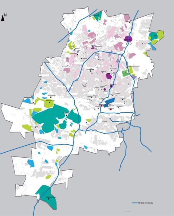
2 Corridors of freedom
3 How to leverage the corridors of freedom opportunities for economic efficiency, social inclusion, resilience and climate change mitigation? How to strategize TOD for spatial transformation towards a spatially integrated and unified city?


4 How to make corridors of freedom a success?
5 ISSUES HIGH LEVELS OF FRAGMENTATION OF SPATIAL FORMS ARE A STRONG BARRIER TRANSFORMING SPATIAL FORMS AT GLOBAL AND LOCAL SCALE IS KEY TO LEVERAGING CORRIDORS OF FREEDOM OPPORTUNITIES 1. Inverted polycentricity 2. Fragmented and scattered urban forms 3. Fragmented and scattered densities fold variations in residential density - 50 fold variation in job density - Spatial mismatch between jobs and residential density 4. Spatial inequalities result in high levels of concentrated unemployment 5. Unequal density of amenities
6 ISSUES 6. Inefficient land use: low coverage ratio and low FAR 7. Uniform and rigid platting (plot subdivision) jeopardizes social inclusiveness and economic resilience 8. Housing prices reveal unsustainability and inefficiencies in land markets 9. Road Classification and Access Management has created high levels of congestion 10. Street densities are low and street patterns are disconnected and clustered, which limits walkability As a result of these constraints, recent densification patterns do not make urban forms more inclusive, efficient and resilient
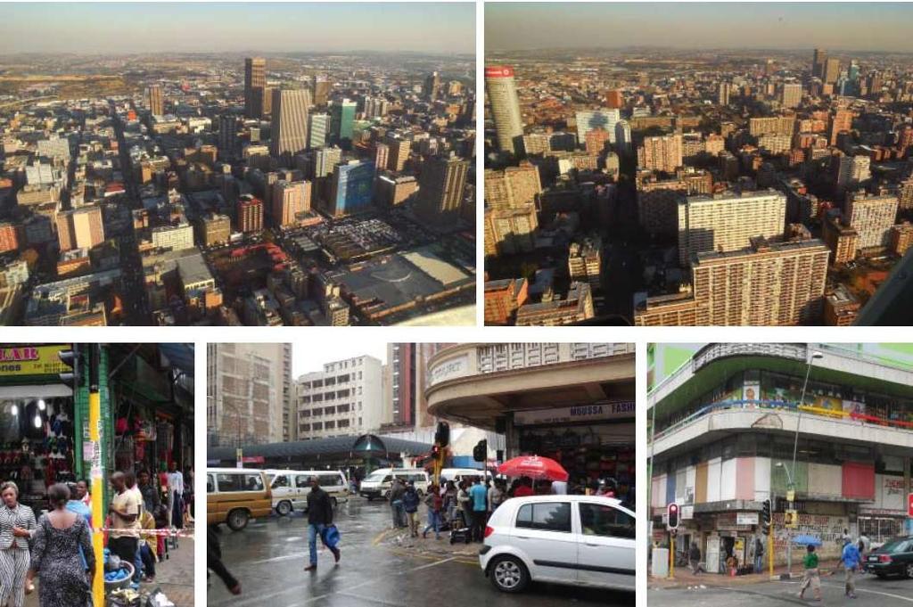
7 1. Inverted polycentricity

8 The traditionnal model Polycentric city The polycentric city is the traditional pattern of city growth, with a dense and large urban core surrounded by dense sub-centers. This structures supports agglomeration economies.
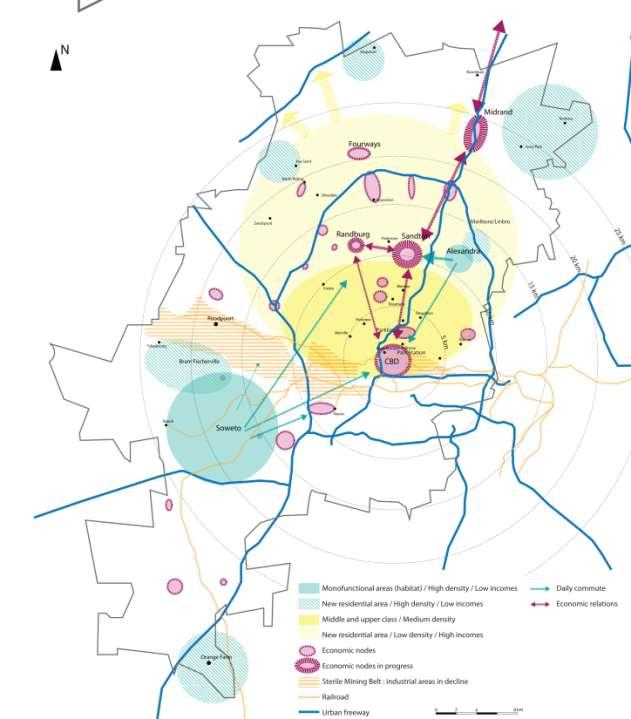
9 Johannesburg Inverted policentricity Johannesburg metropolitan structure is unique and inherited from its complex history. It displays inverted polycentricity, with satellites urban areas much larger than the core of the city.
10 Johannesburg in the 80s
11 Johannesburg today


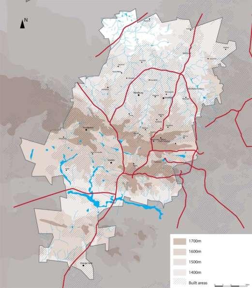
12 Joburg spatial organisation has been shaped by a unique topography

13 Urban growth time lapse in Johannesburg
14 Urban growth time lapse in Johannesburg
15 Urban growth time lapse in Johannesburg
16 Urban growth time lapse in Johannesburg

17 Urban growth time lapse in Johannesburg

18 Urban growth time lapse in Johannesburg
19 Urban growth time lapse in Johannesburg

20 New urbanisation areas


21 A major role of the private sector

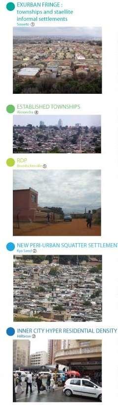
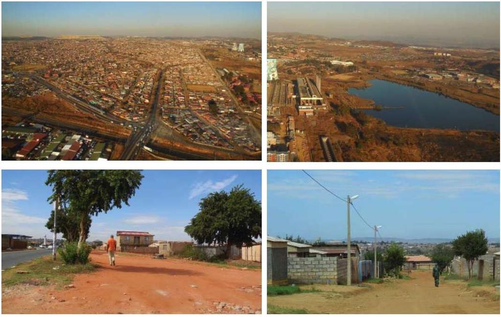
22 180 informal settlement, growing fast
23 2. Fragmented and scattered urban forms

24
25 3. Fragmented and scattered densities fold variations in residential density - 50 fold variation in job density - Spatial mismatch between job and residential density
 6479 inhab/km² in average in built up areas")
26 Residential densities Scattered and fragmented Less than 1000 inhab/km² inhab/km² inhab/km² inhab/km² inhab/km² inhab/km² inhab/km² inhab/km² More than inhab/km² 1644 km², 2600 inhab/km² in average (City of Joburg, census 2010) 6479 inhab/km² in average in built up areas (680 km²)
 44519 51685 40000 Paris (average) 20000 0 Public transit threshold 1496 1445 1045 3145 1137 9950 15722")
27 Population density (inhab/km²) Detailed analysis reveals very different patterns, with 100-fold variations of local residential density Paris (peaks) Paris (average) Public transit threshold

28 Jobs densities (2001 data) jobs/km² jobs/km² jobs/km² jobs/km² jobs/km² jobs/km² jobs/km²
29 The major issue The job/housing mismatch jobs/km² jobs/km² jobs/km² jobs/km² jobs/km² jobs/km² jobs/km²


30 Business densities mirror job distributions Number of businesses per km²
31 Number of businesses for 1000 inhabitants Businesses per km² The number of businesses per km² & the number of businesses per 1000 inhabitants reveal deep spatial inequalities

32 4. Spatial inequalities result in high levels of concentrated unemployment
33 5. Unequal densities of amenities


34 Unequal densities of amenities Hillbrow Bramfischerville


35 Unequal densities of amenities Houghton Northriding
36 Urban amenities per km² The density of urban amenities varies a lot across districts Schools Religious buildings Malls Hospitals/Clinics Bramfischerville Hillbrow Houghton Estate Northriding
37 Urban amenities per thousand inhabitants But the number of amenities per thousand inhabitants varies even more Schools Religious buildings Malls Hospitals/Clinics Bramfischerville Hillbrow Houghton Estate Northriding
38 6. Inefficient land use: low coverage ratio and low FAR
39 Building footprint Coverage ratio 60% 55% 50% 46% 45% 48% 40% 36% 30% 20% 10% 29% 11% 16% 21% 27% 26% 0%
40 Floor Area Ratio Floor Area Ratio is very low in most of urban types Paris
41 7. Uniform and rigid platting (plot subdivision) jeopardizes social inclusiveness and economic resilience


42 What are the characteristics of an efficient, resilient and sustainable platting? Manhattan Original plot subdivision Average plot size: 205 m² Residential Manhattan Intermediary plot consolidation Average plot size: 255 m² Fine grain platting allows consolidation over time and makes the city resilient, diverse and adaptive to market Mixed use Manhattan Extreme plot consolidation Average plot size: 6,100 m² Large businesses
 and its longer evolution The largest plot is 2000 m2.")
43 Log size Highly adaptive platting follows a mathematical regularity characteristic of scale free complex systems: Frequency of sizes follows an inverse power law New York City Wall Street Wall Street s plot area scaling coefficient is similar to Paris reflecting the European origin of this part of the city (New Amsterdam) and its longer evolution The largest plot is 2000 m y = x R² = Log rank Source: Urban Morphology Institute

44 Log size Manhattan Madison square area Mixed-use area % 80% 60% 40% 20% y = x R² = % <250 m² m² m² m² m² 0 >10000 m² Log rank

45 Log size New York City Brooklyn Residential area 9 100% 80% y = x R² = % 40% 20% % <250 m² m² m² m² m² >10000 m² Log rank

46 Hillbrow 100% 80% 60% 40% 20% 0% <250 m² m² m² m² m² >10000 m²

47 Houghton Estate 100% 80% 60% 40% 20% 0% <250 m² m² m² m² m² >10000 m²

48 100% 80% Northriding 60% 40% 20% 0% <250 m² m² m² m² m² >10000 m²

49 100% 90% 80% 70% 60% 50% 40% 30% 20% 10% 0% Soweto <250 m² m² m² m² m² >10000 m²

50 100% 80% Bramfischerville 60% 40% 20% 0% <250 m² m² m² m² m² >10000 m²
51 8. Housing prices reveal unsustainability and inefficiencies in land markets
52 Housing costs (%) Housing costs (%) Housing costs (%) Housing prices reveal unsustainability and inefficiencies in land markets Almost all informal shacks and over 90% of dwellings in sites and services schemes are valued at under R 20,000. What is surprising here is that over 90% of RDP houses (the public sector formal subsidized houses) are also valued at under R 20,000. In other words, they are worth less than what it cost to build them. This is probably the clearest indication of the poor choice of location for these settlements Old Township House RDP House Informal Shacks Shacks in Sites and Services Mid-income House Upper-income House House Price (ZAR)
53 9. Road Classification and Access Management has created high levels of congestion

54 From grids to suburban trees The evolution of South African urban forms from the grid to the suburban tree is not an emergent process. It results directly from traffic engineering and has been entirely prescribed: Road classification Access management

55 The street is a machine for circulation Le Corbusier The paradigm switch of modernism gave the street a purely functional role. In traditional urban planning, such as in European cities, streets used to be at the crossing of all urban activities such as living, working, businesses and human interactions. Streets were places for people. With modernist urban planning, streets became roads. They became the result of only the optimization of transportation flows. Highly constrained network urbanism in Randhart
56 «It is not possible for a road to efficiently perform more than one function at a time. It must therefore function either as a mobility road, or as an activity / access street Without Road Classification and Access Management, your citizens are doomed to continue with unsafe roads, streets congestion and frustration If you are not convinced, there s no hope for your city, town or country Dr John Sampson South African Road Federation
57 Function Description Mobility Traffic Basic Function alternate functional descriptions determining function Class number Class name through traffic components Distance between parallel roads (km) % of built km Reach of Connectivity expected range of average daily traffic % of travel vehicle-km Mobility vehicle priority, vehicle only, long distance, through, high order, high speed, numbered, commercial, economic, strategic; route, arterial road or highway. movement is dominant, through traffic is dominant, the majority of traffic does not originate or terminate in the immediate vicinity, the function of the road is to carry high volumes of traffic between urban districts 1 Principal arterial (freeway) exclusively 7-10 km 3% > 10 km % 2 Major arterial predominant 1,5-5,0km 3% 5-20 km % 3 Minor arterial major 0,8-1,5km 5% 1-10 km % Access / Activity access, mixed pedestrian and vehicle traffic, short distance, low order, low speed, community, street access, turning and crossing movements are allowed, the majority of traffic has an origin or destination in the immediate area, the function of the road is to provide a safe environment for vehicles and pedestrians using access points 4a 4b 5a 5b 6a Collector, commercial Collector, residential Local street, commercial Local street, residential Walkway, pedestrian priority discourage 7% < 2 km if continuous, <4 km if destination % discourage 20% 0,5-3 km max < % prevent 12% < 1 km < % prevent 50% < 0,5; 1 km max < % ban < 1 km 6b Walkway, pedestrian only ban < 1 km

58 40 years of Road Classification and Access Management later RACM has massively fed urban sprawl. Because of urban sprawl, the highway system is reaching its limits with under-capacity causing traffic congestion, notably in the vicinity of major hubs.
59 10. Street densities are low and street patterns are disconnected and clustered, which limits walkability

60 Most of the street patterns have been created recently following modernist principles
61 Cumulated street length per km² (km/km²) Street network typology in Joburg Street length per km² Road Classification and Access Management (RCAM)
62 Average distance between intersections (m) Street network typology in Joburg Average distance between intersection RCAM
63 Number of intersections per km² Street network typology in Joburg Number of intersections per km² RCAM

64 Entrance points per km² Street network typology in Joburg Entrance points per km² RCAM Towards gating and control urbanism
65 Street networks have moved toward clustering, disconnection and control Proportion of T junctions North Riding Daynfern estate 1 Melrose Arch Sandton Bram Fisherville Kya Sand Houghton Estate Alexandra Maboneng Soweto High income urban areas: Toward gating and clustering Low income areas: Toward less and less connectivity Hillbrow 0 Proportion of X-junctions 1


66 Maximum betweenness centrality Increase in clustering and control in Tshwane 700 Silver Lakes Irene Brooklyn Relative clustering coefficient


67 The collapse in the number of entrance points makes congestion issues worse
68 Number of intersections per km² Number of intersections per km² International best practice for high walkability
69 Cumulated street length km/km² Cumulated street length per km²
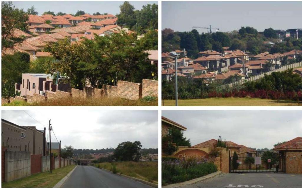
70 Distance between intersections (m) Average distance between intersections International best practice for high walkability
71 As a result of these constraints on urban forms RECENT DENSIFICATION PATTERNS DO NOT MAKE URBAN FORMS MORE INCLUSIVE, RESILIENT AND EFFICIENT Hillbrow Bramfischerville Northriding 4 patterns of densification in Joburg Houghton

72 4 districts with recent densification patterns Hillbrow Bramfischerville Houghton Estate Northriding
73 Equivalent urban areas for 5000 inhabitants
74 Hillbrow


75 Densification in the city center Through over occupancy The urban fabric remains the same, but the floor area per inhabitant drops
76 Bramfischerville


77 Bramfischerville Backyarding densification (shacks) From an extremely low FAR (0.14) to a very low FAR (0.3)

78 Houghton Estate


79 Densification in residential districts Plot subdivision under market pressure Densification through subdivision of plots in Houghton Estate
80 Northriding

81 Densification patterns in Northern residential areas Densification within the gates
82 OPPORTUNITIES
83
84 TOD compact urban forms are dense, accessible, mixed use and adaptive Articulated density Residential density matches with job density Human density matches with transit infrastructure capacity High gross built density High density of amenities Accessibility and proximity Each part of the city is easily accessible Easy access to public transit infrastructures Seamlessly interconnected transit infrastructures Daily amenities accessible by foot (shops, health, education, culture, sport) Intense street network (high number of intersections per km²) Mixed use and adaptive Jobs, housing and retail are mixed on the city, district, community and building scale Land use is highly flexible
85 Opportunities of Corridors of Freedom Integrate local and regional planning Build transit systems that maximize development potential Strategize about ways to encourage the development of high performing communities around transit stations Generate new tools for economic development, real estate and investment issues Improve affordability and livability for all members of the community Respond to imperatives for climate change and sustainability
86 Thank you for your attention
CORRIDORS OF FREEDOM Access Management (Ability) Herman Pienaar: Director City Transformation and Spatial Planning
 Herman Pienaar: Director City Transformation and Spatial Planning") CORRIDORS OF FREEDOM Access Management (Ability) 2016 Herman Pienaar: Director City Transformation and Spatial Planning PLANNING DEVELOPMENT PROCESS RATHER THAN A PLAN CAPITAL INVESTMENT DEVELOPMENT FACILITATION
CORRIDORS OF FREEDOM Access Management (Ability) 2016 Herman Pienaar: Director City Transformation and Spatial Planning PLANNING DEVELOPMENT PROCESS RATHER THAN A PLAN CAPITAL INVESTMENT DEVELOPMENT FACILITATION
The 3V Approach. Transforming the Urban Space through Transit Oriented Development. Gerald Ollivier Transport Cluster Leader World Bank Hub Singapore
 Transforming the Urban Space through Transit Oriented Development The 3V Approach Gerald Ollivier Transport Cluster Leader World Bank Hub Singapore MDTF on Sustainable Urbanization The China-World Bank
Spatial profile of three South African cities
 Spatial Outcomes Workshop South African Reserve Bank Conference Centre Pretoria September 29-30, 2009 Spatial profile of three South African cities by Alain Bertaud September 29 Email: duatreb@msn.com
Subject: Note on spatial issues in Urban South Africa From: Alain Bertaud Date: Oct 7, A. Spatial issues
 Page 1 of 6 Subject: Note on spatial issues in Urban South Africa From: Alain Bertaud Date: Oct 7, 2009 A. Spatial issues 1. Spatial issues and the South African economy Spatial concentration of economic
The implications of backyard housing for spatial planning policy in Johannesburg
 CSIR Policy Brief 1 The implications of backyard housing for spatial planning policy in Johannesburg Introduction This policy brief focuses on a specific form of informal housing in South Africa. Backyard
The Spatial Structure of Cities: International Examples of the Interaction of Government, Topography and Markets
 Module 2: Spatial Analysis and Urban Land Planning The Spatial Structure of Cities: International Examples of the Interaction of Government, Topography and Markets Alain Bertaud Urbanist Summary What are
Leveraging Urban Mobility Strategies to Improve Accessibility and Productivity of Cities
 Leveraging Urban Mobility Strategies to Improve Accessibility and Productivity of Cities Aiga Stokenberga World Bank GPSC African Regional Workshop May 15, 2018 Roadmap 1. Africa s urbanization and its
East Bay BRT. Planning for Bus Rapid Transit
 East Bay BRT Planning for Bus Rapid Transit Regional Vision Draper Prison The Bottleneck is a State-Level issue, Salt Lake County 2050 Population: 1.5M Draper Prison hopefully with some State-Level funding!
SECTION 5 KEY FOCUS AREAS
 SECTION 5 KEY FOCUS AREAS 164 5.1. Development Focus and Implementation Within Region E there are six Key Focus Areas for the City of Johannesburg. These are areas where interventions will have the greatest
MULTIPLE CHOICE. Choose the one alternative that best completes the statement or answers the question.
 AP Test 13 Review Name MULTIPLE CHOICE. Choose the one alternative that best completes the statement or answers the question. 1) Compared to the United States, poor families in European cities are more
Sustainable Suburbs: Restructuring Suburban Development
 Sustainable Suburbs: Restructuring Suburban Development Stephen B. Friedman, AICP, CRE ULI Forum, October 8, 2009 The Vocabulary of Growth CAVE NIMBY BANANA NOTE NOPE NIMEY Triple Bottom Line Profitability
CERTIFIED RESOLUTION. introduction: and dated May 29, 2017, as attached, as appropriate
 15322 Buena Vista Avenue, White Rock BC, Canada V4B 1Y6 www.whiterockcity.ca City of White Rock P: 604.541.22121 F: 604.541.9348 /2tC% City Clerk s Office IT E ROC K June 13,2017 Stephanie Lam, Deputy
How networks are shaping the city of Tshwane Serge Salat Urban Morphology Institute, Paris
 How networks are shaping the city of Tshwane Serge Salat Urban Morphology Institute, Paris With the collaboration of Darren Nel, Albert Ferreira & Loeiz Bourdic Citizens patterns of interaction Street
Vincent Goodstadt. Head of European Affairs METREX European Network
 Vincent Goodstadt Head of European Affairs METREX European Network METREX (Network of 50 European Metropolitan Regions and Areas ) Exchanging Knowledge (e.g. Benchmarking) Climate Change CO2/80/50 Expertise
HSC Geography. Year 2013 Mark Pages 10 Published Jul 4, Urban Dynamics. By James (97.9 ATAR)
") HSC Geography Year 2013 Mark 92.00 Pages 10 Published Jul 4, 2017 Urban Dynamics By James (97.9 ATAR) Powered by TCPDF (www.tcpdf.org) Your notes author, James. James achieved an ATAR of 97.9 in 2013 while
HSC Geography Year 2013 Mark 92.00 Pages 10 Published Jul 4, 2017 Urban Dynamics By James (97.9 ATAR) Powered by TCPDF (www.tcpdf.org) Your notes author, James. James achieved an ATAR of 97.9 in 2013 while
_INTRODUCTION TSHWANE...3 EXISTING SPATIAL FORM... 3 NATURE OF THE PROBLEM...3 STUDY AREA...5 INTRODUCTION
 CHAPTER: 1 _INTRODUCTION TSHWANE...3 EXISTING SPATIAL FORM... 3 NATURE OF THE PROBLEM...3 STUDY AREA...5 INTRODUCTION 2 TSHWANE Pretoria, the inner city region of Tshwane, a place of great significance,
MODULE 1 INTRODUCING THE TOWNSHIP RENEWAL CHALLENGE
 MODULE 1 INTRODUCING THE TOWNSHIP RENEWAL CHALLENGE FOCUS OF THE MODULE Township renewal challenges and developmental outcomes covered in this module: Historical origins of townships and the inherited
Note on Transportation and Urban Spatial Structure
 Note on Transportation and Urban Spatial Structure 1 By Alain Bertaud, Washington, ABCDE conference, April 2002 Email: duatreb@msn.com Web site: http://alain-bertaud.com/ http://alainbertaud.com/ The physical
Urban Geography Unit Test (Version B)
") Urban Geography Unit Test (Version B) 1. What function do the majority of the world s ten most populated cities serve? a. a fortress city to resist foreign invasion b. a port city for transporting people
Urban Geography Unit Test (Version B) 1. What function do the majority of the world s ten most populated cities serve? a. a fortress city to resist foreign invasion b. a port city for transporting people
Measuring connectivity in London
 Measuring connectivity in London OECD, Paris 30 th October 2017 Simon Cooper TfL City Planning 1 Overview TfL Connectivity measures in TfL PTALs Travel time mapping Catchment analysis WebCAT Current and
Economic Activity Economic A ctivity
 5 Economic Economic Activity Activity ECONOMIC ACTIVITY 5.1 EMPLOYMENT... 5-7 5.1.1 OBJECTIVE... 5-7 5.1.2 POLICIES... 5-7 5.2 PROTECTING THE AREA OF EMPLOYMENT... 5-9 5.2.1 OBJECTIVE... 5-9 5.2.2 POLICIES...
Tackling urban sprawl: towards a compact model of cities? David Ludlow University of the West of England (UWE) 19 June 2014
 19 June 2014") Tackling urban sprawl: towards a compact model of cities? David Ludlow University of the West of England (UWE) 19 June 2014 Impacts on Natural & Protected Areas why sprawl matters? Sprawl creates environmental,
Tackling urban sprawl: towards a compact model of cities? David Ludlow University of the West of England (UWE) 19 June 2014 Impacts on Natural & Protected Areas why sprawl matters? Sprawl creates environmental,
IOP Conference Series: Earth and Environmental Science. Related content OPEN ACCESS
 IOP Conference Series: Earth and Environmental Science OPEN ACCESS Using GIS to integrate the analysis of land-use, transportation, and the environment for managing urban growth based on transit oriented
Vital city lively neighborhood living center
 From the ugliest place to heart of the suburb Vital city lively neighborhood living center Marja Straver - Nevalainen September 12 th, 2012 If you want to see the sun, t th look next to it to NL FI 10x
Riocan Centre Study Area Frontenac Mall Study Area Kingston Centre Study Area
 OVERVIEW the biggest challenge of the next century (Dunham Jones, 2011). New books are continually adding methods and case studies to a growing body of literature focused on tackling this massive task.
Local Area Key Issues Paper No. 13: Southern Hinterland townships growth opportunities
 Draft Sunshine Coast Planning Scheme Review of Submissions Local Area Key Issues Paper No. 13: Southern Hinterland townships growth opportunities Key Issue: Growth opportunities for Southern Hinterland
6 th GLOBAL SUMMIT ON URBAN TOURISM 4 6 December 2017, Kuala Lumpur (Malaysia)
") 6 th GLOBAL SUMMIT ON URBAN TOURISM 4 6 December 2017, Kuala Lumpur (Malaysia) SUMMARY/CONCLUSIONS Esencan TERZIBASOGLU Director Destination Management and Quality eterzibasoglu@unwto.org 6TH GLOBAL SUMMIT
6 th GLOBAL SUMMIT ON URBAN TOURISM 4 6 December 2017, Kuala Lumpur (Malaysia) SUMMARY/CONCLUSIONS Esencan TERZIBASOGLU Director Destination Management and Quality eterzibasoglu@unwto.org 6TH GLOBAL SUMMIT
Contemporary Human Geography 3 rd Edition
 Contemporary Human Geography 3 rd Edition Chapter 13: Urban Patterns Marc Healy Elgin Community College Services are attracted to the Central Business District (CBD) because of A. accessibility. B. rivers.
Committee Meeting November 6, 2018
 Committee Meeting November 6, 2018 Agenda Where we are in the process Land Use Plan Transportation Element Housing & Neighborhoods Elements Next Steps Schedule November 6: Plan Elements December: Plan
Urbanization and Sustainable Development of Cities: A Ready Engine to Promote Economic Growth and Cooperation
 Urbanization and Sustainable Development of Cities: A Ready Engine to Promote Economic Growth and Cooperation Wan Portia Hamzah Institute of Strategic and International Studies (ISIS) Malaysia 10 September
Key Issue 1: Why Do Services Cluster Downtown?
 Key Issue 1: Why Do Services Cluster Downtown? Pages 460-465 ***Always keep your key term packet out whenever you take notes from Rubenstein. As the terms come up in the text, think through the significance
BUILDING SOUND AND COMPARABLE METRICS FOR SDGS: THE CONTRIBUTION OF THE OECD DATA AND TOOLS FOR CITIES AND REGIONS
 BUILDING SOUND AND COMPARABLE METRICS FOR SDGS: THE CONTRIBUTION OF THE OECD DATA AND TOOLS FOR CITIES AND REGIONS STATISTICAL CAPACITY BUILDING FOR MONITORING OF SUSTAINABLE DEVELOPMENT GOALS Lukas Kleine-Rueschkamp
Urban Planning Word Search Level 1
 Urban Planning Word Search Level 1 B C P U E C O S Y S T E M P A R E U O E U R B A N P L A N N E R T N S T D H E C O U N T Y G E R E R D W R E N I C I T Y C O U N C I L A A A S U G G C I L A G P R I R
Transit-Oriented Development. Christoffer Weckström
 Transit-Oriented Development Christoffer Weckström 31.10.2017 Outline Context of Transit-oriented Development Elements of Transit-oriented Development A short history of land use and transit integration
Size matters: issues and challenges of local development with a special focus on small and medium sized towns in Czechia
 Size matters: issues and challenges of local development with a special focus on small and medium sized towns in Czechia Luděk Sýkora Charles University, Faculty of Science Dept. of Social Geography and
Financing Urban Transport. UNESCAP-SUTI Event
 Financing Urban Transport UNESCAP-SUTI Event October 2017 Urban Transport in Context 2 The spiky urban economy of global cities 3 Mass transit networks converge towards a characteristic structure with
Key Issue 1: Why Do Services Cluster Downtown?
 Key Issue 1: Why Do Services Cluster Downtown? Pages 460-465 1. Define the term CBD in one word. 2. List four characteristics of a typical CBD. Using your knowledge of services from chapter 12, define
INTERNATIONAL EXPERIENCE IN INNOVATIONS IN METRO RAIL. Gerald Ollivier Transport Cluster Leader Singapore, World Bank
 INTERNATIONAL EXPERIENCE IN INNOVATIONS IN METRO RAIL Gerald Ollivier Transport Cluster Leader Singapore, World Bank Innovation 1: Density Aligned with Transit From Serge Salat London s Jobs densities
CHAPTER 4 HIGH LEVEL SPATIAL DEVELOPMENT FRAMEWORK (SDF) Page 95
 Page 95") CHAPTER 4 HIGH LEVEL SPATIAL DEVELOPMENT FRAMEWORK (SDF) Page 95 CHAPTER 4 HIGH LEVEL SPATIAL DEVELOPMENT FRAMEWORK 4.1 INTRODUCTION This chapter provides a high level overview of George Municipality s
CHAPTER 4 HIGH LEVEL SPATIAL DEVELOPMENT FRAMEWORK (SDF) Page 95 CHAPTER 4 HIGH LEVEL SPATIAL DEVELOPMENT FRAMEWORK 4.1 INTRODUCTION This chapter provides a high level overview of George Municipality s
Melaka Sustainability Outlook: Rapid Assessment Diagnostic. Serge Salat Lincoln Lewis
 Melaka Sustainability Outlook: Rapid Assessment Diagnostic Serge Salat Lincoln Lewis Introduction to the Process Project Initiation: Green Technology Melaka, the local stakeholder, requested the assessment
São Paulo Metropolis and Macrometropolis - territories and dynamics of a recent urban transition
 São Paulo Metropolis and Macrometropolis - territories and dynamics of a recent urban transition Faculty of Architecture and Urbanism of São Paulo University Prof. Dr. Regina M. Prosperi Meyer WC2 - World
Date: June 19, 2013 Meeting Date: July 5, Consideration of the City of Vancouver s Regional Context Statement
 Section E 1.5 To: From: Regional Planning and Agriculture Committee Lee-Ann Garnett, Senior Regional Planner Planning, Policy and Environment Department Date: June 19, 2013 Meeting Date: July 5, 2013 Subject:
Regional Snapshot Series: Transportation and Transit. Commuting and Places of Work in the Fraser Valley Regional District
 Regional Snapshot Series: Transportation and Transit Commuting and Places of Work in the Fraser Valley Regional District TABLE OF CONTENTS Complete Communities Daily Trips Live/Work Ratio Commuting Local
Local Economic Activity Around Rapid Transit Stations
 Local Economic Activity Around Rapid Transit Stations The Case of Chicago s Orange Line Julie Cooper, MPP 2014 Harris School of Public Policy Transport Chicago June 6, 2014 Motivation Impacts of transit
New Partners for Smart Growth: Building Safe, Healthy, and Livable Communities Mayor Jay Williams, Youngstown OH
 New Partners for Smart Growth: Building Safe, Healthy, and Livable Communities Mayor Jay Williams, Youngstown OH The City of Youngstown Youngstown State University Urban Strategies Inc. Youngstown needed
Together towards a Sustainable Urban Agenda
 Together towards a Sustainable Urban Agenda The City We (Youth) Want Preliminary findings from youth consultations Areas Issue Papers Policy Units 1.Social Cohesion and Equity - Livable Cities 2.Urban
Knowledge claims in planning documents on land use and transport infrastructure impacts
 Knowledge claims in planning documents on land use and transport infrastructure impacts Presentation at the Final Workshop of the research project "Innovations for sustainable public transport in Nordic
Policy Note 6. Measuring Unemployment by Location and Transport: StepSA s Access Envelope Technologies
 6 Measuring Unemployment by Location and Transport: StepSA s Access Envelope Technologies Introduction Increasing emphasis is coming onto spatial planning as government in South Africa moves to address
Foreword. Vision and Strategy
 GREATER MANCHESTER SPATIAL FRAMEWORK Friends of Walkden Station Consultation Response January 2017 Foreword Friends of Walkden Station are a group of dedicated volunteers seeking to raise the status and
[ ] MONITORING THE SPATIAL IMPACTS OF THE EGNATIA MOTORWAY egnatia odos observatory
![[ ] MONITORING THE SPATIAL IMPACTS OF THE EGNATIA MOTORWAY egnatia odos observatory](/thumbs/72/66290986.jpg "[ ] MONITORING THE SPATIAL IMPACTS OF THE EGNATIA MOTORWAY egnatia odos observatory") ] egnatia odos observatory MONITORING THE SPATIAL IMPACTS OF THE EGNATIA MOTORWAY 2014 http://observatory.egnatia.gr MINISTRY OF INFRASTRUCTURE, TRANSPORT AND NETWORKS 2 A tool at the service of spatial
] egnatia odos observatory MONITORING THE SPATIAL IMPACTS OF THE EGNATIA MOTORWAY 2014 http://observatory.egnatia.gr MINISTRY OF INFRASTRUCTURE, TRANSPORT AND NETWORKS 2 A tool at the service of spatial
Integrated Infrastructure Planning & Spatial Mapping
 Integrated Infrastructure Planning & Spatial Mapping Presenter: Heidi Dixon, Principal Social Planner, DTPLI 23 May 2014 PART 1 PLAN MELBOURNE : Metropolitan Planning Strategy PART 2 Case Study: DTPLI
Transport Planning in Large Scale Housing Developments. David Knight
 Transport Planning in Large Scale Housing Developments David Knight Large Scale Housing Developments No longer creating great urban spaces in the UK (Hall 2014) Transport Planning Transport planning processes
The CRP stresses a number of factors that point to both our changing demographics and our future opportunities with recommendations for:
 Plan Overview The CRP represents the first broad planning initiative covering Lake, Porter and LaPorte counties. Unlike previous plans released by NIRPC, which focused primarily on transportation, the
Indicator : Proportion of population that has convenient access to public transport, by sex, age and persons with disabilities
 Goal 11: Make cities and human settlements inclusive, safe, resilient and sustainable Target 11.2: By 2030, provide access to safe, affordable, accessible and sustainable transport systems for all, improving
THE LEGACY OF DUBLIN S HOUSING BOOM AND THE IMPACT ON COMMUTING
 Proceedings ITRN2014 4-5th September, Caulfield and Ahern: The Legacy of Dublin s housing boom and the impact on commuting THE LEGACY OF DUBLIN S HOUSING BOOM AND THE IMPACT ON COMMUTING Brian Caulfield
MOR CO Analysis of future residential and mobility costs for private households in Munich Region
 MOR CO Analysis of future residential and mobility costs for private households in Munich Region The amount of the household budget spent on mobility is rising dramatically. While residential costs can
Urban development. The compact city concept was seen as an approach that could end the evil of urban sprawl
 The compact city Outline 1. The Compact City i. Concept ii. Advantages and the paradox of the compact city iii. Key factor travel behavior 2. Urban sustainability i. Definition ii. Evaluating the compact
accessibility accessibility by-pass bid-rent curve bridging point administrative centre How easy or difficult a place is to reach.
 accessibility accessibility How easy or difficult a place is to reach. How easy or difficult it is to enter a building. administrative centre bid-rent curve The function of a town which is a centre for
Council Workshop on Neighbourhoods Thursday, October 4 th, :00 to 4:00 p.m. Burlington Performing Arts Centre
 Council Workshop on Neighbourhoods Thursday, October 4 th, 2012 1:00 to 4:00 p.m. Burlington Performing Arts Centre Agenda Introductions Warm-Up Exercise Presentation Exercise Neighbourhood Planning Break
Dar es Salaam - Reality Check Workshop
 Dar es Salaam - Reality Check Workshop hosted by GIZ and Dar es Salaam City Council Introduction: Key Urban Characteristics of Dar es Salaam Challenges and Opportunities for Resilient Development in the
King City URA 6D Concept Plan
 King City URA 6D Concept Plan King City s Evolution Among the fastest growing cities 2000 Census 1,949 2010 Census 3,111 60% increase 2016 Census estimate 3,817 23% increase Average annual rate 4.3% Surpassing
RURAL-URBAN PARTNERSHIPS: AN INTEGRATED APPROACH TO ECONOMIC DEVELOPMENT
 RURAL-URBAN PARTNERSHIPS: AN INTEGRATED APPROACH TO ECONOMIC DEVELOPMENT William Tompson Head of the Urban Development Programme OECD Public Governance and Territorial Development Directorate JAHRESTAGUNG
Vienna urban development - seestadt aspern as urban future lab
 Vienna urban development - seestadt aspern as urban future lab PERMACULTURE DESIGN COURSE * 2012 * ASPERN SEESTADT 1 Christof Schremmer, ÖIR Austrian Institute for Regional Studies and Spatial Planning
European spatial policy and regionalised approaches
 Findings of the ESPON 2006 Programme COMMIN Final Conference 26-27 April 2007 European spatial policy and regionalised approaches by Dr. Kai BöhmeB ! Territory matters Structure of presentation! Territorial
convenience truth 4 concepts and their SYNTHESIS a convenience truth 5.0
 5.0 Concept 1 Interconnected Places: Use the framework of our arterials to both connect and distinguish urban places Vancouver s existing urban structure, based on the original streetcar city pattern,
FOURTH URBAN RESEARCH SYMPOSIUM URBAN LAND USE AND LAND MARKETS. WASHINGTON D.C., U.S.A. May 2007
 FOURTH URBAN RESEARCH SYMPOSIUM URBAN LAND USE AND LAND MARKETS WASHINGTON D.C., U.S.A. May 2007 METROPOLITAN MONTEVIDEO: LAND USES AND URBAN LAND MARKET CLUSTER 1 ISABEL VIANA URUGUAY METROPOLITAN MONTEVIDEO
International Guidelines on Access to Basic Services for All
 International Guidelines on Access to Basic Services for All Presentation and initials lessons from implementation Accessibility to services in regions and cities : measures and policies, OECD 18 June
Alternatives Analysis
 Alternatives Analysis Prepared for: Metropolitan Atlanta Rapid Transit Authority Prepared by: AECOM/Jacobs-JJG Joint Venture Atlanta, GA November 2012 Page Left Intentionally Blank ii TABLE OF CONTENTS
Opportunities and challenges of HCMC in the process of development
 Opportunities and challenges of HCMC in the process of development Lê Văn Thành HIDS HCMC, Sept. 16-17, 2009 Contents The city starting point Achievement and difficulties Development perspective and goals
I. M. Schoeman North West University, South Africa. Abstract
 Urban Transport XX 607 Land use and transportation integration within the greater area of the North West University (Potchefstroom Campus), South Africa: problems, prospects and solutions I. M. Schoeman
How to measure Territorial Cohesion and Cooperation?
 How to measure territorial cohesion and cooperation? How to measure Territorial Cohesion and Cooperation? Brussels: 21 February Growth, Development or Cohesion? Economic Competitiveness Social Cohesion
Urban Pattern Geometry and its Potential Energy Efficiency
 DOI: 10.14621/tna.20170104 Urban Pattern Geometry and its Potential Energy Efficiency Anna Yunitsyna* 1, Ernest Shtepani 2 1 Department of Architecture, Epoka University Tirana, Albania; ayunitsyna@epoka.edu.al
Land Use and Zoning Page 1 of 10 LAND USE AND ZONING
 LAND USE AND ZONING Land Use and Zoning Page 1 of 10 BACKGROUND The Clifton-Fruitvale planning area is about 3,962 acres (6.2 sq. miles) with a population of 14,000 residents. The density of the area is
Accessibility as an Instrument in Planning Practice. Derek Halden DHC 2 Dean Path, Edinburgh EH4 3BA
 Accessibility as an Instrument in Planning Practice Derek Halden DHC 2 Dean Path, Edinburgh EH4 3BA derek.halden@dhc1.co.uk www.dhc1.co.uk Theory to practice a starting point Shared goals for access to
Urban Growth and Transportation Development Patterns for China s Urban Transition
 Urban Growth and Transportation Development Patterns for China s Urban Transition Qisheng Pan Professor and Chair, Department of Urban Planning and Environmental Policy, Texas Southern University President,
REVITALIZATION PROCESSES OF OLD INDUSTRIALIZED REGION IN THE CONTEXT OF FUNCTIONAL URBAN AREAS. Justyna Gorgoń
 STUDIA REGIONALIA Volume 47, 2016, pp. 87 94 doi: 10.12657/studreg-47-06 Journal of the Polish Academy of Sciences: Committee for Spatial Economy and Regional Planning & European Regional Science Association
DRAFT NODAL REVIEW City of Johannesburg
 DRAFT NODAL REVIEW 2018 City of Johannesburg City Transformation and Spatial Planning February 2018 Table of Contents Figures... 1 Tables... 2 1. Introduction... 3 1.1. Why a Nodal Review?... 3 1.2. Applying
Measuring Disaster Risk for Urban areas in Asia-Pacific
 Measuring Disaster Risk for Urban areas in Asia-Pacific Acknowledgement: Trevor Clifford, Intl Consultant 1 SDG 11 Make cities and human settlements inclusive, safe, resilient and sustainable 11.1: By
National Planning Framework Louth County Council Submission
 National Planning Framework 2040 Louth County Council Submission 10 th November 2017 2 Louth County Council Introduction The primacy of the Dublin / Belfast corridor in the urban network on the island
STRATEGY FOR SPATIAL PLANNING AND RENEWAL OF URBAN POLICY: THE SOFA OF CENTRAL METROPOLITAN AREA
 KINGDOM OF MOROCCO MINISTRY OF SPATIAL DEVELOPMENT, WATER AND ENVIRONMENT STRATEGY FOR SPATIAL PLANNING AND RENEWAL OF URBAN POLICY: THE SOFA OF CENTRAL METROPOLITAN AREA STATE AND ORIENTATION OF THE SNAT
Chapter 12. Services
 Chapter 12 Services Where di services originate? Key Issue #1 Shoppers in Salzburg, Austria Origins & Types of Services Types of services Consumer services Business services Public services Changes in
2 nd Semester. Core Courses. C 2.1 City and Metropolitan Planning. Module 1: Urban Structure and Growth Implications
 2 nd Semester Core Courses C 2.1 City and Metropolitan Planning Module 1: Urban Structure and Growth Implications Growth of cities; cities as engine of growth; urban sprawl; land value, economic attributes
The Governance of Land Use
 The planning system The Governance of Land Use United Kingdom Levels of government and their responsibilities The United Kingdom is a unitary state with three devolved governments in Northern Ireland,
CREATING LIVEABLE & SAFE CITIES FOR ALL
 CREATING LIVEABLE & SAFE CITIES FOR ALL Taking Transit to people s door steps PRERNA V. MEHTA, MANAGER, WRI INDIA RAJEEV G. MALAGI, SR. PROJECT ASSOCIATE, WRI INDIA A product of WRI Ross Center for Sustainable
INCLUSIVE URBAN REGENERATION IN JOHANNESBURG: The Case of Ekhaya Residential City Improvement District in Hillbrow
 INCLUSIVE URBAN REGENERATION IN JOHANNESBURG: The Case of Ekhaya Residential City Improvement District in Hillbrow HISTORICAL OVERVIEW: HILLBROW JOHANNESBURG EARLY ESTABLISHMENT & DEVELOPMENT POLITICS:
Urban Geography. Unit 7 - Settlement and Urbanization
 Urban Geography Unit 7 - Settlement and Urbanization Unit 7 is a logical extension of the population theme. In their analysis of the distribution of people on the earth s surface, students became aware
MEASUREMENT OF URBAN SPRAWL AND COMPACTNESS CHARACTERISTICS NASIRIYAH CITY - IRAQ AS CASE STUDY
 International Journal of Civil Engineering and Technology (IJCIET) Volume 9, Issue 9, September 2018, pp. 335 343, Article ID: IJCIET_09_09_035 Available online at http://www.iaeme.com/ijciet/issues.asp?jtype=ijciet&vtype=9&itype=9
The sustainable location of low-income housing development in South African urban areas
 Sustainable Development and Planning II, Vol. 2 1165 The sustainable location of low-income housing development in South African urban areas S. Biermann CSIR Building and Construction Technology Abstract
Managing Growth: Integrating Land Use & Transportation Planning
 Managing Growth: Integrating Land Use & Transportation Planning Metro Vancouver Sustainability Community Breakfast Andrew Curran Manager, Strategy June 12, 2013 2 Integrating Land Use & Transportation
Data driven approaches to Urban Planning Experience from Derry/Londonderry
 Data driven approaches to Urban Planning Experience from Derry/Londonderry Anna Rose RTPI Belfast 11 th of September 1 June 26 07:47AM 2 The value of the City The space of the city is a theatre: playing
Achieving the Vision Geo-statistical integration addressing South Africa s Developmental Agenda. geospatial + statistics. The Data Revolution
 Achieving the Vision Geo-statistical integration addressing South Africa s Developmental Agenda geospatial + statistics The Data Revolution humble beginnings, present & future - South Africa UN World Data
Identifying Megaregions in the US: Implications for Infrastructure Investment
 7. 10. 2 0 08 Identifying Megaregions in the US: Implications for Infrastructure Investment Dr. Myungje Woo Dr. Catherine L. Ross Jason Barringer Harry West Jessica Lynn Harbour Doyle Center for Quality
Proposed Scope of Work Village of Farmingdale Downtown Farmingdale BOA Step 2 BOA Nomination Study / Draft Generic Environmental Impact Statement
 Proposed Scope of Work Village of Farmingdale Downtown Farmingdale BOA Step 2 BOA Nomination Study / Draft Generic Environmental Impact Statement The scope of work that follows incorporates and covers
GIS Analysis of Crenshaw/LAX Line
 PDD 631 Geographic Information Systems for Public Policy, Planning & Development GIS Analysis of Crenshaw/LAX Line Biying Zhao 6679361256 Professor Barry Waite and Bonnie Shrewsbury May 12 th, 2015 Introduction
The population within the AMC limits was 4.5 million in 2001 (Census of India 2001). The Sabarmati River divides the city in two parts. The city s tra
. The Sabarmati River divides the city in two parts. The city s tra") EXPLORING THE RELATIONSHIP BETWEEN URBAN ROADS, URBAN FORM AND ECONOMIC ACTIVITY IN AHMEDABAD USING SPACE SYNTAX Arindam Majumdar 1, Richard Sliuzas 2, Talat Munshi 1, Mark Brussel 2 1 Center for Environmental
EXPLORING THE RELATIONSHIP BETWEEN URBAN ROADS, URBAN FORM AND ECONOMIC ACTIVITY IN AHMEDABAD USING SPACE SYNTAX Arindam Majumdar 1, Richard Sliuzas 2, Talat Munshi 1, Mark Brussel 2 1 Center for Environmental
Crow River Plaza - Retail Development South Diamond Lake Rd. Rogers, MN FOR LEASE 1,024 SF Retail Space. Lease Rate: $16.
 FEATURES: - Available in Rogers, MN Lease Rate: $16.00 / psf NNN - Excellent location with freeway signage on I-94! - Near large retailers such as Target, Kohls, & Applebees. Taxes $3.65 / psf Cam $3.20
Port Cities Conference: How Regional Planning can Help Support a Competitive Port. Christina DeMarco Metro Vancouver
 Port Cities Conference: How Regional Planning can Help Support a Competitive Port Christina DeMarco Metro Vancouver June 12. 2008 Metro Vancouver Regional Growth Management Three ways to help support the
It is clearly necessary to introduce some of the difficulties of defining rural and
 UNIT 2 CHANGING HUMAN ENVIRONMENTS G2 Theme 2 Investigating Settlement Change in MEDCs 2.1 What are the distinctive features of settlements? It is clearly necessary to introduce some of the difficulties
Engagement on Strategies to Overcome Inequality
 Engagement on Strategies to Overcome Inequality Civil Society Engagement with Poverty Julian Sendin 1-2 June 2017 Kievits Kroon Country Estate, Pretoria, South Africa 1. Ndifuna Ukwazi Ndifuna Ukwazi is
Factors Affecting Human Settlement
 Factors Affecting Human Settlement Physical Factors One of the most basic factors affecting settlement patterns is the physical geography of the land. Climate is key, because if a place is too dry, too