State: TX County: Wharton Code: 481 Zip Code: Number of Resources within Property: Contributing Noncontributing. 'o'
|
|
|
- Valentine Sparks
- 5 years ago
- Views:
Transcription

1 NPS Form (Rev. 8-86) United States Department of the Interior National Park Service NATIONAL REGISTER OF HISTORIC PLACES REGISTRATION FORM OMB No FEB NATIONAL REGISTER 1. NAME OF PROPERTY Historic name: Texas and New Orleans Railroad Bridge Other name/site number: Site No LOCATION Street & number: 1/4 mile west of U.S. Highway 59, near Bell Street City/town: Wharton Not for publication: N/A State: TX County: Wharton Code: 481 Zip Code: CLASSIFICATION Ownership of Property: Private Category of Property: Structure Number of Resources within Property: Contributing Noncontributing 'o' _0_ buildings _0_ sites _0_ structures 0 objects 0 Totid Number of contributing resources previously listed in the Natiorud Register: N/A Name of related multiple property listing: Historic and Architectural Resources of Wharton, Wharton County, Texas

2 *USDI/NPS NRHP Registration Form Page ffl 4. STATE/FEDERAL AGENCY CERTIFICATION As the designated authority under the National Historic Preservation Act of 1986, as amended, I hereby certify that this x nomination request for determination of eligibility meets the documentation standards for registering properties in the National Register of Historic Places and meets the procedural and professional requirements set forth in 36 CFR Part 60. In my opinion, the property x meets does not meet the National Register criteria. See CQii&nuatic Signanire of certifying offipfat Date <;tatp Hi<:tr>rif Prpg/rvatinn Offirpr Tpvag Migtnripal rnmmigginn State or Federal agency and bureau In my opinion, the property meets does not meet the National Register criteria. See continuation sheet. Signature of commenting or other official Date State or Federal agency and bureau 5. NATIONAL PARK SERVICE CERTIFICATION I, hereby certify that this property is: ^ ^^^^i^eg^^- * entered in the National Register See continuation sheet. determined eligible for the National Register _ See continuation sheet. determined not eligible for the National Register removed from the National Register other (explain): Sjgnature of the Keeper Date of Action

3 *USDI/NPS NRHP Registration Form Page #3 6. FUNCTION OR USE Historic: TRANSPORTATION: Rail-related Currem: TRANSPORTATION: RaU-related 7. DESCRIPTION Architectural Classification: OTHER: Camelback Through/Pratt Through Truss Materials: fouruiation Stone walls N/A roof N/A other Steel Describe presem arui historic physical appeararwe. X See continuation sheet. 8. STATEMENT OF SIGNIFICANCE Certifying official has considered the significarwe of this property in relation to other properties: locally Applicable Natiorml Register Criteria: A Criteria Considerations (Exceptions) : N/A Areas of Significarwe: Transportation Period(s) of Significance: Significam Dates: 1903 Significam Person(s): N/A Cultural Affiliation: N/A Architect/Builder: Unknown State significarwe of property, arui justify criteria, criteria considerations, and areas and periods of significarwe rwted above. X See cominuation sheet.
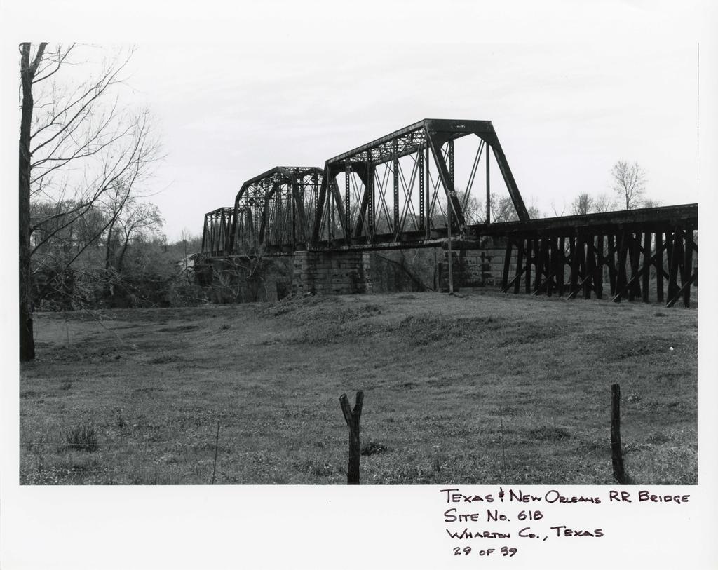
4 HPSFoml0*0O< OUB Approvm No 101*0018 United States Department of the Interior National Park Service National Register of Historic Places Continuation Sheet Section number Page ^ 3^''*! and New Orleans RR Bridge " Wharton, Wharton County, Texas Description: The Texas and New Orleans Railroad Bridge is a 3-part, steel truss railroad bridge crossing the Colorado River on a northwest-southeast axis. I t consists of a combination of 7-part Camelback-through truss section connected on the north and south ends with single 6-panel Pratt-through truss sections. Large rusticated limestone blocks form the pylons supporting each span. The northwest approach crosses relatively flat terrain and is constructed of braced timber piers supporting single railroad tracks. The Texas and New Orleans Railroad Bridge is a 3-part, steel truss railroad bridge crossing the Colorado River on a northwest-southeast axis. The northern section of the bridge is approached along a roughly 100 foot approach on braced timber piers. This section crosses rolling river bottom land now used for agricultural purposes. The southern section goes directly onto the opposite river bank. The bridge is roughly 1/4 mile south of the Texas and New Orleans Railroad Depot in Wharton (Site No. 614) and 1/4 mile west of U.S. Highway 59. The bridge consists of a combination of 7-part Camelback-through truss section connected on the north and south ends with single 6-panel Pratt- through truss sections. Large rusticated limestone blocks form the pylons supporting each span. The date of "1903" is found on the upper steel trusses on the main section. The bridge is now in poor condition and rarely used. I t is heavily scarred with rust and evidence of weatherization.
 Railroad Bridge (1903) is one of two historic bridges crossing the Colorado River in Wharton.")
5 HPS Fom l<y*0l>4 OUB Approvm Mo 101*0018 (8*8) United States Department of the Interior National Park Service National Register of Historic Places Continuation Sheet Section number ^ Page ^ It""^^ and New oneans RR Bridge ^ Wharton, Wharton County, Texas Statement of Significance: The Texas and New Orleans (T.& N.O.) Railroad Bridge (1903) is one of two historic bridges crossing the Colorado River in Wharton. It is an excellent example of the development of bridge technology that allowed Wharton to be connected to other parts of the country by rail. This connection, in turn, provided the economic boost to the local economy that allowed the community to prosper in the early 20th century. The bridge is nominated under Criterion A and associated with the context: Community Development in Wharton, Texas, The Texas and New Orleans Railroad Bridge (1903) exemplifies the technological development in bridges that allowed the Colorado River to be spanned and thus open up Wharton to additional economic development. With this technology and construction of the bridge, Wharton was able to expand agricultural markets as well as receive goods from other areas of the country. Lumber, bricks, feed, and even early automobiles may have reached the Wharton market in the first few decades of the 20th century by rail. Moreover, this bridge allowed the T.& N.O. Railroad Company (later purchased by the Southern Pacific Railroad Company) to expand its service to South Texas from Houston and thereby reach the livestock ranches in that area. Despite its poor condition, the structure retains its integrity and is one of two remaining local resources from the railroad era evidence of the rail contribution to the community. It is also one of two historic bridges crossing the Colorado River at Wharton. Rail service was discontinued to Wharton around 1990.
: N/A prelimirmry determirmtion of individual listing (36 CFR 67) has been requested.")
6 *USDI/NPS NRHP Registration Form Page #4 9. MAJOR BIBLIOGRAPHICAL REFERENCES See bibliography of historic context statement. _x_ See cominuation sheet. Previous dociunemation on file (NPS): N/A prelimirmry determirmtion of individual listing (36 CFR 67) has been requested. _ previously listed in the Natiorml Register _ previously determined eligible by the Natiorml Register _ designated a Natiorml Historic Landmark _ recorded by Historic American Buildings Survey ff _ recorded by Historic American Engirwering Record ff Primary Location of Additiorml Data: X State historic preservation office (Texas Historical Commission^ _ Other state agerwy _ Federal agerwy _ Local govemmem _ University _ Other ~ Specify Repository: 10. GEOGRAPHICAL DATA Acreage of Property: Less than one acre UTM Refererwes: Zone Easting Northing Zorw Easting Northing A B C D See continuation sheet. Verbal Bouruiary Description: The width of theright-of-wayof Southern Pacific Railroad, including the bridge structure and its approaches. Boundary Justification: The property includes all areas historically associated with the structure as built. 11. FORM PREPARED BY (assisted by Dwayne Jones, Preservation Planner, THC staff) Name/Title: Ed Galloway and Ralph Newlan Organization: Hardy-Heck-Moore Date: July 1989 January 1992 Street & Number: 2112 Rio Grande Telephone: Ory or ToviTi; Austin State: TX Zip
7 NPS FofTTl (8-86) OMB ApprovflNo. pproval No United States Department of the Interior National Park Service National Register of Historic Places Continuation Sheet Section number Page Wharton MPS Wharton County, TEXAS 21. House at 401 North Richmond 22. House at 512 North Resident fciterea In t'be Utlon*l Re«i»^ at;ered in tsli tiatlqoal BeglBt* Date Listed ^//y/93 3MA9J 23. Linn Street Historic District SubstaatlvQ Bevie* Merrill Roten House Moran Moore House entered fn ia» ^ e^^^^^^"^.<xi^tiooal H9gi»ty '.nterel Q'W' Speaker, J. H., House ( j^,tlon*3. S^"'*'' St. John's Evengelical Lutheran Church ^attred 28. Texas and New Orleans Railroad Depot f^tloq&l Begl«^ tntered In fbw 29. Texas and New Orleans Railroad Bridge I«.tiOIial Bogles 3//>^Al 3//sA^ V/^A9^ ^//^A9^> ^A^^/9-^ ^//^Af^ 30. West Milam Street Mercantile Historic District totered in the Jjc/<^:i 31. Worthing, Louis F., House intered 3 'QB dfttioiuul Ifttionaa Baglat*^ ^//fr/r^ ^//S-A9
8 UNITED STATES DEPARTMENT OF THE INTERIOR NATIONAL PARK SERVICE NATIONAL REGISTER OF HISTORIC PLACES EVALUATION/RETURN SHEET REQUESTED ACTION: NOMINATION PROPERTY Texas and New Orleans Railroad Bridge NAME : MULTIPLE NAME: Wharton MPS STATE & COUNTY: TEXAS, Wharton DATE RECEIVED: 2/01/93 DATE OF PENDING LIST: 2/16/93 DATE OF 16TH DAY: 3/04/9 3 DATE OF 4 5TH DAY: 3/18/9 3 DATE OF WEEKLY LIST: REFERENCE NUMBER: NOMINATOR: STATE REASONS FOR REVIEW: APPEAL: N DATA PROBLEM: N LANDSCAPE: N LESS THAN 50 YEARS: N OTHER: N PDIL: N PERIOD: N PROGRAM UNAPPROVED: N REQUEST: N SAMPLE: N SLR DRAFT: N NATIONAL: N COMMENT WAIVER: N iccept RETURN REJECT ^//S^A ^ DATE ^tlonfl^i^fl.... ABSTRACT/SUMMARY COMMENTS: RECOM./CRITERIA REVIEWER DISCIPLINE DATE DOCUMENTATION see attached comments Y/N see attached SLR Y/N
9 CLASSIFICATION count resource type STATE/FEDERAL AGENCY CERTIFICATION FUNCTION historic current DESCRIPTION.architectural classification.materials.descriptive text SIGNIFICANCE Period Areas of Significance Check and justify below Specific dates Statement of Significance Builder/Architect (in one paragraph).summary paragraph.completeness.clarity.applicable criteria.justification of areas checked.relating significance to the resource.context.relationship of integrity to significance.justification of exception.other BIBLIOGRAPHY GEOGRAPHICAL DATA acreage verbal boundary description UTMs boundary justification ACCOMPANYING DOCUMENTATION/PRESENTATION sketch maps USGS maps photographs presentation OTHER COMMENTS Questions concerning this nomination may be directed to Phone Signed Date
10
11 Please refer to the map in the Multiple Property Cover Sheet for this property Multiple Property Cover Sheet Reference Number:
NATIONAL REGISTER OF HISTORIC PLACES REGISTRATION FORM NATIONAL
 /3 NPS Form 10-900 (Rev. 8-86) United States Department of the National Park Service Interior OMB No. 1024-0018 p r [] \^! ^ NATIONAL REGISTER OF HISTORIC PLACES REGISTRATION FORM NATIONAL 1. Name of Property
National Register of Historic Places Registration Form
 United States Department of the Interior National Park Service National Register of Historic Places Registration Form This form is for use in nominating or requesting determinations for individual properties
1 'o' Number of contributing resources previously listed in the National Register: N/A
 NPS Form 10-900 (Rev. 8-86) United States Department of the Interior National Park Service NATIONAL REGISTER OF HISTORIC PLACES REGISTRATION FORM OMB No. 1024-0018 FEB 01 1993 NATIONAL B&GISTER 1. NAME
0 buildings public-state. sites public-federal _ structure structures. 1 ~ir~ Total
 NPSFoTn : C -900 lr«v. 8-a
United States Department of the Interior National Park Service National Register of Historic Places Registration Form.
 NPS Fo-m -.C-SOO tr«. S-8«> United States Department of the Interior National Park Service National Register of Historic Places Registration Form 4SJ OMBNa 1024-001S FEB 1 e )gnj This form is tor use in
Brockschmidt-Miller House Spires, Timothy, House; #359
 NPSFOTH ; C-900 (Rev. 8-8S1 United States Department of the Interior National Park Sen/ice National Register of Historic Places Registration Form FEB 1 6 1990 OMB No. 1024-0018 NATIONAL This form is for
United States Department of the Interior National Park Service. State Historic Preservation Officer, Texas Historical Commission
 NPS Form 10-900 (Oct. 1990) OMB NO. 10024-0018 United States Department of the Interior National Park Service NATIONAL REGISTER OF HISTORIC PLACES REGISTRATION FORM 1. NAME OF PROPERTY HISTORIC NAME: Lindsay,
National Register of Historic Piaces Registration Form
 NPS FoTn '.C-SOO (Rev. 8-86) United States Department of the Interior National Park Sen/ice National Register of Historic Piaces Registration Form NATIONAL REGISTER OMB Na 1024-001S This form is for use
National Register of Historic Places Registration Form
 United States Department of the Interior National Park Service National Register of Historic Places Registration Form This form is for use in nominating or requesting determinations for individual properties
Number of Resources within Property buildings
 NPS Foin. C -900 tnn. 6-66) United States Department of the Interior National Park Sen/ice National Register of Historic Places Registration Form i FEB 1 6 --J NATIONAL OMB No. 1024-0018 This form is for
/O/U / 013 om NO
 k s ~ i m (Rev. 886) 10900 l\l e L C S ~ /O/U / 013 om NO. 10240018 'Jnited States Department of the Interfor National Park Service NATIONAL REGISTER OF HISTORIC PIACES REGISTRATION FORM B=b 1. Name of
Vnited States D e w t. not for publication: N/A city/town: Waldron. in Arkansas of the Interior. National Park Service
 Vnited States D e w t National Park Service of the Interior WATfONAL REGISTER OF EtS!FORIC PLACES REGISTRATION FORM I, Name of Property - - - -. --- historic name: Poteau Work Center Residence #2 other
MAY National Register of Historic Places Registration Form. United States Department of thie interior National Park Service
 NPS FoTTi '.C-9CX} IPm. 6-66) United States Department of thie interior National Park Service National Register of Historic Places Registration Form OMBNa. 10040016 r \ LlLl,,«v n C 1QQ1 ' MAY 0 6 1991
MAY C C 1S91. United States Department of tiie interior National Parl< Service National Register of Historic Places Registration Form
 NPS Fo-m. C-900 irn. 6-661 United States Department of tiie interior National Parl< Service Registration Form *' OMB No. 1024-0018 MAY C C 1S91 NATIONAL REGISTER This form is for use in nominating or requesting
FEB 1 6 LJ. National Register of Historic Places Registration Form. United States Department of the Interior National Parl< Service
 NPS Foin C-900 (R». 6-661 United States Department of the Interior National Parl< Service National Register of Historic Places Registration Form FEB 1 6 LJ OMB No. 1034-0018 NATfOMAL REGISTER This form
National Register of Historic Places Inventory Nomination Form. 1. Name '' ; 2. Location jf J M COMMERCIAL BUILDINGS IN STILLWATER
 NPS Form 10-900 (3-82) 0MB No. 1024-0018 Exp. 10-31-84 United States Department off the Interior National Park Service National Register of Historic Places Inventory Nomination Form See instructions in
Current Functions (Enter categories from instructions) Materials (Enter categories from instructions)
 Materials (Enter categories from instructions)") Site Inventory Form State Inventory No. 92-00490 New Supplemental State Historical Society of Iowa Part of a district with known boundaries (enter inventory no.) 92-00349 (November 2005) Relationship:
Site Inventory Form State Inventory No. 92-00490 New Supplemental State Historical Society of Iowa Part of a district with known boundaries (enter inventory no.) 92-00349 (November 2005) Relationship:
Ownership of Property Category of Property Number of Resources within Property X private X building(s) Contributing Noncontributing
 Contributing Noncontributing") NPS FoTn -0-900 (Rev. 8-86) United States Department of the Interior National Park Service National Register of Historic Places Registration Form V60 FEB 1 6 19^3 OMB Na 1024-0018 NATiONAL REGISTER This
NPS FoTn -0-900 (Rev. 8-86) United States Department of the Interior National Park Service National Register of Historic Places Registration Form V60 FEB 1 6 19^3 OMB Na 1024-0018 NATiONAL REGISTER This
Current Functions (Enter categories from instructions) 02G04: Commerce/Trade - tavern 14D09: Transportation automotive service
 02G04: Commerce/Trade - tavern 14D09: Transportation automotive service") Site Inventory Form State Inventory No. 29-03500 New Supplemental State Historical Society of Iowa Part of a district with known boundaries (enter inventory no.) 29-03522 (November 2005) Relationship:
Site Inventory Form State Inventory No. 29-03500 New Supplemental State Historical Society of Iowa Part of a district with known boundaries (enter inventory no.) 29-03522 (November 2005) Relationship:
BLOCK QUAD LOT DATE:_. PERIOD: ownf.r J u l i a Countryman THEME:
 COUNTY CITY BLOCK QUAD NAMP. C o u n t r y m a n H o u s e AnnBFss402 E. 9t.h 23-24 LOT _ rnnntvharris CITY: H O t i S t P n UTM: ARCHITECT/BUILDER:. DATE:_ 1907-08 PERIOD: ownf.r J u l i a Countryman
i TE:,Qi"if?inaI o 11 iirgs and uryden
 MAY 2 0 1980 i TE:,Qi"if?inaI o 11 iirgs and uryden ALTERATIONS- interior remodeling 1964 SIGWFICANCE a good southwestern example of Georgian Revival architecture in a planned academic setting AREA OF
A^^mm. ADDRESS: 1846 Harvard
 COUNTY CITY Q"^P Woman's C l u b 105 BLOCK 25 LOT ADDRESS: 1846 Harvard COUNTY:. H a r r i s ritv- H o u s t o n UTM: ARCHITECT/BUILDER: nu-mfb-hnnston H e i g h t s W o m a n ' s n n h IPAfi u^r-^r^rd
Historic Cultural Properties Inventory (HCPI) Base Form (FORM 1)
 Base Form (FORM 1)") Historic Cultural Properties Inventory (HCPI) Base Form (FORM 1) Historic Preservation Division, New Mexico Office of Cultural Affairs For HPD Office use only: HCPI No. District No. NRHP: SRCP: Criteria:
Historic Cultural Properties Inventory (HCPI) Base Form (FORM 1) Historic Preservation Division, New Mexico Office of Cultural Affairs For HPD Office use only: HCPI No. District No. NRHP: SRCP: Criteria:
COLORADO CULTURAL RESOURCE SURVEY Management Data Form Rev. 11/10
 COLORADO CULTURAL RESOURCE SURVEY OAHP1400 Rev. 11/10 A should be completed for each cultural resource recorded during an archaeological survey. Isolated finds and revisits are the exception and they do
BLOCK QUAD LOT. _ ritv- H o u s t o n UTM:. STYLE:.
 COUNTY CITY NAME ADDRESS: 1421 Harvard ftpruitrrt/riinnfrwm. rtu-mitp. H a r o l d R. 157 BLOCK QUAD A. W i l s o n - b u i l d e r Elsom LOT _ COUNTY:^ H a r r i s _ ritv- H o u s t o n UTM:. natf1905
Historic Cultural Properties Inventory (HCPI) Base Form (FORM 1)
 Base Form (FORM 1)") Historic Cultural Properties Inventory (HCPI) Base Form (FORM 1) Historic Preservation Division, New Mexico Office of Cultural Affairs For HPD Office use only: HCPI No. District No. NRHP: SRCP: Criteria:
Historic Cultural Properties Inventory (HCPI) Base Form (FORM 1) Historic Preservation Division, New Mexico Office of Cultural Affairs For HPD Office use only: HCPI No. District No. NRHP: SRCP: Criteria:
STYLE: THEME: s l i g h t l y arched doorway on second l e v e l i s main entrance^ w i t h.ggtiarpri (rnni-. BUILDING MATERIAL: wau:
 COUNTY CITY MAD MAMF-Tmmanuel L u t h e r a n Church AnnpF«;
Appendix I-1: Archaeological Records Search
 Appendix I-1: Archaeological Records Search South Central Coastal Information Center California State University, Fullerton Department of Anthropology MH-426 800 North State College Boulevard Fullerton,
APPLICATION TO AMEND THE FUTURE LAND USE MAP (FLUM) SMALL SCALE
 SMALL SCALE") DEPARTMENT OF DEVELOPMENT & PLANNING 825 Ohio Avenue - Lynn Haven, FL 32444 (850) 265-2961 - (850) 265-3478 APPLICATION TO AMEND THE FUTURE LAND USE MAP (FLUM) SMALL SCALE Deadline to submit is 30 days
DEPARTMENT OF DEVELOPMENT & PLANNING 825 Ohio Avenue - Lynn Haven, FL 32444 (850) 265-2961 - (850) 265-3478 APPLICATION TO AMEND THE FUTURE LAND USE MAP (FLUM) SMALL SCALE Deadline to submit is 30 days
Sacred Lands File & Native American Contacts List Request
 Sacred Lands File & Native American Contacts List Request NATIVE AMERICAN HERITAGE COMMISSION 915 Capitol Mall, RM 364 Sacramento, CA 95814 (916) 653-4082 (916) 657-5390 Fax nahc@pacbell.net Information
BLOCK QUAD LOT _ COUNTY:. DATE:
 COUNTY CITY NAME. ADDRESS: 301-303 E. 15th LOT _ COUNTY:. Harris _ ritv: Houston _ ARCHITECT/BUILDER: JJ8. p t. 13-14 BLOCK QUAD UTM: DATE:_ STYLE:. THEME: 1 904 PERIOD :- QU'Mirp.Macaria D. Sanchez 301
Historic Cultural Properties Inventory (HCPI) Base Form (FORM 1)
 Base Form (FORM 1)") Historic Cultural Properties Inventory (HCPI) Base Form (FORM 1) Historic Preservation Division, New Mexico Office of Cultural Affairs For HPD Office use only: HCPI No. District No. NRHP: SRCP: Criteria:
Historic Cultural Properties Inventory (HCPI) Base Form (FORM 1) Historic Preservation Division, New Mexico Office of Cultural Affairs For HPD Office use only: HCPI No. District No. NRHP: SRCP: Criteria:
APPLICATION FOR CONDITIONAL ABSOLUTE WATER STORAGE RIGHT
 District Court, Water Division, Colorado Court Address: CONCERNING THE APPLICATION FOR WATER RIGHTS OF Applicant: In the River or its Tributaries In COUNTY Attorney or Party Without Attorney (Name and
Name of Applicant Mailing Address address Telephone Number
 District Court, Water Division, Colorado Court Address: CONCERNING THE APPLICATION FOR WATER RIGHTS OF Applicant: In the River or its Tributaries In COUNTY Attorney or Party Without Attorney (Name and
ADDITIONAL PHASE IA ARCHAEOLOGICAL SURVEY FOR THE UMORE PARK SAND AND GRAVEL MINING ENVIRONMENTAL REVIEW SERVICES, DAKOTA COUNTY, MINNESOTA
 ADDITIONAL PHASE IA ARCHAEOLOGICAL SURVEY FOR THE UMORE PARK SAND AND GRAVEL MINING ENVIRONMENTAL REVIEW SERVICES, DAKOTA COUNTY, MINNESOTA ADDENDUM I Submitted to: Short Elliot Hendrickson, Inc. Submitted
How to Complete the NH Division of Historical Resources Area Form
 NEW HAMPSHIRE DIVISION OF HISTORICAL RESOURCES State of New Hampshire, Department of Cultural Resources 603-271-3483 19 Pillsbury Street, P. O. Box 2043, Concord NH 03302-2043 603-271-3558 FAX 603-271-3433
City of Lockport Historic Resources Survey - Section METHODOLOGY
 2.0 METHODOLOGY Clinton Brown Company PN 07-008 2-1 April 2011 2.0 METHODOLOGY This methodology statement is prepared as part of the project tasks. It outlines the research sources identified, field strategies,
Attached you will find files containing information on the sites and surveys we have in our database for the location you requested.
 Attached you will find files containing information on the sites and surveys we have in our database for the location you requested. These files include Microsoft Office Excel spreadsheets with database
OWNER: Mr> vt bwi"^ NHL ]RTHi7. roof: AtP.f^ DATE:-1:11:13 Al: LOT : NAME. COUNTY: CITY:_ ARCH ITECT/BU n npg] P.O.
![OWNER: Mr> vt bwi^ NHL ]RTHi7. roof: AtP.f^ DATE:-1:11:13 Al: LOT : NAME. COUNTY: CITY:_ ARCH ITECT/BU n npg] P.O.](/thumbs/93/114425611.jpg "OWNER: Mr> vt bwi^ NHL ]RTHi7. roof: AtP.f^ DATE:-1:11:13 Al: LOT : NAME. COUNTY: CITY:_ ARCH ITECT/BU n npg] P.O.") COUNTY BLOCK 6AS LOT : NAME COUNTY: CITY:_ PERIOD: -XLL ARCH ITECT/BU n npg] P.O. ei^-f^,r DATE:_ OWNER: Mr> vt bwi"^ THEME:_ STYLE: FYLf \;ic-hvi'ai/\ DESCRIPJION: 1- Sfhrxi P )
COUNTY BLOCK 6AS LOT : NAME COUNTY: CITY:_ PERIOD: -XLL ARCH ITECT/BU n npg] P.O. ei^-f^,r DATE:_ OWNER: Mr> vt bwi"^ THEME:_ STYLE: FYLf \;ic-hvi'ai/\ DESCRIPJION: 1- Sfhrxi P )
Creating A-16 Compliant National Data Theme for Cultural Resources
 Creating A-16 Compliant National Data Theme for Cultural Resources Cultural Resource GIS Facility National Park Service John J. Knoerl Deidre McCarthy Paper 169 Abstract OMB Circular A-16 defines a set
JOURNAL OF THE CSXT HISTORICAL SOCIETY Volume 7 Number 2
 JOURNAL OF THE CSXT HISTORICAL SOCIETY Volume 7 Number 2 A CSXT MONON SYSTEM ABANDONMENT CSXTHS is not affiliated with CSX Transportation and is a nonprofit corporation chartered under the laws of Kentucky.
Appendix: AmaTerra Environmental, Inc. A-1
 Appendix Appendix: Survey Forms AmaTerra Environmental, Inc. A-1 El Camino Real from Oñate Crossing to Misión de Guadalupe A-2 AmaTerra Environmental, Inc. SURVEY AND EVALUATION OF OLD FORT BLISS AT HART
TREASURE COAST REGIONAL PLANNING COUNCIL M E M O R A N D U M. To: Council Members AGENDA ITEM 4B10
 TREASURE COAST REGIONAL PLANNING COUNCIL M E M O R A N D U M To: Council Members AGENDA ITEM 4B10 From: Date: Subject: Staff December 14, 2018 Council Meeting Local Government Comprehensive Plan Review
DIRECTORY OF COAL MINES IN ILLINOIS 7.5-MINUTE QUADRANGLE SERIES SORENTO SOUTH QUADRANGLE BOND & MONTGOMERY COUNTIES
 DIRECTORY OF COAL MINES IN ILLINOIS 7.5-MINUTE QUADRANGLE SERIES SORENTO SOUTH QUADRANGLE BOND & MONTGOMERY COUNTIES Jennifer M. Obrad 2013 Prairie Research Institute William W. Shilts, Executive Director
 Red River Flooding June 2015 Caddo and Bossier Parishes Presented by: Flood Technical Committee Where the Rain Falls Matters I-30 versus I-20 I-20 Backwater and Tributary Floods (Localized) 2016 Flood
APPLICATION FOR CHANGE OF WATER RIGHT
 District Court, Water Division, Colorado Court Address: CONCERNING THE APPLICATION FOR WATER RIGHTS OF Applicant: In the River or its Tributaries In COUNTY COURT USE ONLY Attorney or Party Without Attorney
RAILROAD COMMISSION OF TEXAS OIL & GAS DIVISION
 API No. Drilling Permit # 4-003-47034 SWR Exception Case/Docket No. 6. Purpose of filing (mark ALL appropriate boxes): 7. Wellbore Profile (mark ALL appropriate boxes): 11. RRC District No. 80759 GENERAL
LOT _ COUNTY: _ UTM: PERIOD; STYLE: 530 Harvard Houston. TX 77007
 COUNTY 289 19 BLOCK QUAD NAME:. ADDRFSS- 530 Harvard ARCHITErT/BIin.nF.R:prnh;qhly J o g OWNER: R o s e n d o R u p n t p l l n LOT _ COUNTY: Harris _ ritvhouston _ UTM: n g l p - b l d r P A T F : _ 19Q6-Q7
GIS SERVICE CENTER MAP ORDER FORM
 Steven V. Stenger County Executive Pam Reitz Director of Administration GIS SERVICE CENTER MAP ORDER FORM 1. Print this form. 2. Fill out the form calculate and include the total cost of your order. 3.
2014 UTP Public Meeting July 18, 2013
 2014 UTP Public Meeting July 18, 2013 What is the Unified Transportation Program (UTP)? 3 UTP is Updated Annually by August 31st Spring - Summer 2013 UTP 2014 UTP UTP Development Process 4 UTP Connects
Internet GIS Sites. 2 OakMapper webgis Application
 Internet GIS Sites # Name URL Description 1 City of Sugar Land http://www.sugarlandtx.gov/index.htm It is a city in Texas with 65,000 Residents. The City of Sugar Land, Texas, provides ArcIMS-based maps
Business Office; Multiple Family Dwelling House; Parsonage; Single Family Dwelling House
 Inventory No: Historic Name: HRV.28 Unitarian Church Parsonage Common Name: Address: 5 Littleton Rd City/Town: Village/Neighborhood: Center Local No: 17D-16; 233 Year Constructed: C 1850 Architect(s):
[LLAZC X.L EA0000; AZ SRP ] Notice of Temporary Closures: Selected Public Lands in La Paz County, AZ
![[LLAZC X.L EA0000; AZ SRP ] Notice of Temporary Closures: Selected Public Lands in La Paz County, AZ](/thumbs/89/100188672.jpg "[LLAZC X.L EA0000; AZ SRP ] Notice of Temporary Closures: Selected Public Lands in La Paz County, AZ") This document is scheduled to be published in the Federal Register on 12/29/2017 and available online at https://federalregister.gov/d/2017-28217, and on FDsys.gov 4310-32 DEPARTMENT OF THE INTERIOR Bureau
This document is scheduled to be published in the Federal Register on 12/29/2017 and available online at https://federalregister.gov/d/2017-28217, and on FDsys.gov 4310-32 DEPARTMENT OF THE INTERIOR Bureau
Information Paper. Kansas City District. Missouri River Fish and Wildlife Mitigation Project Jim and Olivia Hare Wildlife Area, MO
 City District Information Paper River Fish and Wildlife Mitigation Project Jim and Olivia Hare Wildlife Area, MO Riverine habitat created in 2004/2005 by modifying existing river structures along the banks,
Response to the Local Government Boundary Commission for England proposals for new electoral arrangements for Leeds City Council
 Response to the Local Government Boundary Commission for England proposals for new electoral arrangements for Leeds City Council This is the Leeds Liberal Democrat response to the Draft Recommendations
Engineer's Report. Main Street Business Area. Festoon Lighting and Sidewalk Cleaning Assessment District (Fiscal Year )
") Engineer's Report for the Main Street Business Area Festoon Lighting and Sidewalk Cleaning Assessment District (Fiscal Year 2008-09) Prepared under the provisions of the Benefit Assessment Act of 1982
Engineer's Report for the Main Street Business Area Festoon Lighting and Sidewalk Cleaning Assessment District (Fiscal Year 2008-09) Prepared under the provisions of the Benefit Assessment Act of 1982
Maryland Bridges in Black & White. Sharing Archival Photos with the Public Using GIS
 Maryland Bridges in Black & White Sharing Archival Photos with the Public Using GIS Introductions Laurie Goudy Maryland State Highway Administration Assistant Division Chief, Data Services Engineering
Commonwealth of Massachusetts Massachusetts Historical Commission 220 Morrissey Boulevard, Boston, Massachusetts
 Inventory No: Historic Name: Common Name: Address: HRV.166 Hapgood, Shadrach House and Farm Lounger, Stephen N. - Roberts, Walter S. House 150 Ayer Rd City/Town: Village/Neighborhood: Local No: 8-43 Year
National Register of Historic Places Inventory Nomination Form
 NPS Form lo-wo-a OMB No. 1024-CX)18 Exp. 10-31-84 United States Department of the Interior National Park Service National Register of Historic Places Inventory Nomination Form NPS UM ortly ved JAN I te
PW Parkway ES Prince William County, Virginia WSSI #
 PW Parkway ES Prince William County, Virginia WSSI #15.3 Cultural Resources Site Assessment November 15 Prepared for: Prince William County Public Schools P.O. Box 39 Manassas, Virginia 1 Prepared by:
RAILROAD COMMISSION OF TEXAS OIL WELL POTENTIAL TEST, COMPLETION OR RECOMPLETION REPORT, AND LOG
 RAILROAD COMMISSION OF TEXAS 1701 N. Congress P.O. Box 12967 Austin, Texas 78701-2967 Status: Form W-2 OIL WELL POTENTIAL TEST, COMPLETION OR RECOMPLETION REPORT, AND LOG Date: Tracking.: Approved 01/05/2016
Proclaiming Certain Lands as Reservation for the Confederated Tribes of the
 This document is scheduled to be published in the Federal Register on 11/05/2018 and available online at https://federalregister.gov/d/2018-24174, and on govinfo.gov [4337-15] DEPARTMENT OF THE INTERIOR
VILLAGE OF ORLAND PARK
 14700 Ravinia Avenue Orland Park, IL 60462 www.orland-park.il.us Ordinance No: File Number: 2013-0373 AN ORDINANCE ESTABLISHING SPECIAL SERVICE AREA NUMBER 3 STATE OF ILLINOIS, COUNTIES OF COOK AND WILL
Alamito Creek Preserve Ranches for Sale Marfa, Presidio County, Texas
 Alamito Creek Preserve Ranches for Sale Marfa, Presidio County, Texas James King, Agent Office 432 426.2024 Cell 432 386.2821 James@KingLandWater.com Alamito Creek Preserve Various size Ranch Properties,
APPLICATION FOR SIMPLE CHANGE IN SURFACE POINT OF DIVERSION PURSUANT TO (3.5), C.R.S.
, C.R.S.") District Court, Water Division, Colorado Court Address: CONCERNING THE APPLICATION FOR WATER RIGHTS OF Applicant: In the River or its Tributaries In COUNTY COURT USE ONLY Attorney or Party Without Attorney
District Court, Water Division, Colorado Court Address: CONCERNING THE APPLICATION FOR WATER RIGHTS OF Applicant: In the River or its Tributaries In COUNTY COURT USE ONLY Attorney or Party Without Attorney
APPROVED JURISDICTIONAL DETERMINATION FORM U.S. Army Corps of Engineers
 APPROVED JURISDICTIONAL DETERMINATION FORM U.S. Army Corps of Engineers This form should be completed by following the instructions provided in Section IV of the JD Form Instructional Guidebook. SECTION
Proposed Scope of Work Village of Farmingdale Downtown Farmingdale BOA Step 2 BOA Nomination Study / Draft Generic Environmental Impact Statement
 Proposed Scope of Work Village of Farmingdale Downtown Farmingdale BOA Step 2 BOA Nomination Study / Draft Generic Environmental Impact Statement The scope of work that follows incorporates and covers
C-62 RELATED ACTS. Priv. Acts 1955, Ch. 275, "An Act to redefine the boundaries of the City of Belle Meade... C-63
 C-62 RELATED ACTS Priv. Acts 1955, Ch. 275, "An Act to redefine the boundaries of the City of Belle Meade... C-63 C-63 CHAPTER NO. 275 1 HOUSE BILL NO. 758 (By Davidson Delegation) AN ACT to redefine the
DIRECTORY OF COAL MINES IN ILLINOIS 7.5-MINUTE QUADRANGLE SERIES BROADWELL QUADRANGLE LOGAN COUNTY. Margaret H. Bargh
 DIRECTORY OF COAL MINES IN ILLINOIS 7.5-MINUTE QUADRANGLE SERIES BROADWELL QUADRANGLE LOGAN COUNTY Margaret H. Bargh Department of Natural Resources ILLINOIS STATE GEOLOGICAL SURVEY 1994 REVISED 2009 DIRECTORY
MAPS AND THEIR CLASSIFICATION
 MAPPING MAPS AND THEIR CLASSIFICATION WHAT IS A MAP? A map is representation of the Earth's surface, showing how things are related to each other by distance, direction, and size. Maps are a way of showing
Cripps Ranch 76+/- Acres Orchard Development Opportunity Dixon, CA. Presented By:
 Cripps Ranch 76+/- Acres Orchard Development Opportunity Dixon, CA Presented By: Cripps Ranch 76+/- Acres Orchard Development Opportunity Dixon, CA Location: This property is located at 5663 Dally Road
Town of Taos Request for Proposal Historic Preservation GIS Geodatabase Project April 2007
 Town of Taos Request for Proposal Historic Preservation GIS Geodatabase Project April 2007 1. Background The Town of Taos is requesting proposals from qualified firms or a team of firms who can develop
Urban Planning Word Search Level 1
 Urban Planning Word Search Level 1 B C P U E C O S Y S T E M P A R E U O E U R B A N P L A N N E R T N S T D H E C O U N T Y G E R E R D W R E N I C I T Y C O U N C I L A A A S U G G C I L A G P R I R
DIRECTORY OF COAL MINES IN ILLINOIS 7.5-MINUTE QUADRANGLE SERIES WOOD RIVER QUADRANGLE MADISON COUNTY Cheri Chenoweth & Melony E.
 DIRECTORY OF COAL MINES IN ILLINOIS 7.5-MINUTE QUADRANGLE SERIES WOOD RIVER QUADRANGLE MADISON COUNTY Cheri Chenoweth & Melony E. Barrett Department of Natural Resources ILLINOIS STATE GEOLOGICAL SURVEY
A. My name is Watsun Randolph and my business address is 45 Horner Street Warrenton
 DIRECT TESTIMONY OF WATSUN RANDOLPH ON BEHALF OF PIEDMONT ENVIRONMENTAL COUNCIL BEFORE THE STATE CORPORATION COMMISSION OF VIRGINIA CASE NOS. PUE-00-000 AND PUE-00-000 0 Q. PLEASE STATE YOUR NAME AND BUSINESS
APPENDIX K NATIONAL HISTORIC PRESERVATION ACT COORDINATION BRAZOS ISLAND HARBOR CHANNEL IMPROVEMENT PROJECT CAMERON COUNTY, TEXAS
 APPENDIX K NATIONAL HISTORIC PRESERVATION ACT COORDINATION BRAZOS ISLAND HARBOR CHANNEL IMPROVEMENT PROJECT CAMERON COUNTY, TEXAS U.S. Army Corps of Engineers, Galveston District 2000 Fort Point Road Galveston,
A Case Study of Regional Dynamics of China 中国区域动态案例研究
 A Case Study of Regional Dynamics of China 中国区域动态案例研究 Shuming Bao Spatial Data Center & China Data Center University of Michigan 1:00 PM - 2:00 PM, Tue, Feb 6, 2018 EST USA A Case Study of Regional Dynamics
[LLAZC03000.L EA0000 LVRCA13SA A, AZ SRP Notice of Temporary Closures of Public Lands in La Paz County, AZ
 This document is scheduled to be published in the Federal Register on 01/15/2013 and available online at http://federalregister.gov/a/2013-00542, and on FDsys.gov 4310-32-P DEPARTMENT OF THE INTERIOR Bureau
AN ARCHAEOLOGICAL SURVEY FOR THE DCP MIDSTREAM THREE RIVERS PLANT TO CGP 51 PROJECT IN LIVE OAK COUNTY, TEXAS
 AN ARCHAEOLOGICAL SURVEY FOR THE DCP MIDSTREAM THREE RIVERS PLANT TO CGP 51 PROJECT IN LIVE OAK COUNTY, TEXAS By William E. Moore Brazos Valley Research Associates Contract Report Number 251 2011 AN ARCHAEOLOGICAL
An Introduction to Field Explorations for Foundations
 An Introduction to Field Explorations for Foundations J. Paul Guyer, P.E., R.A. Paul Guyer is a registered mechanical engineer, civil engineer, fire protection engineer and architect with over 35 years
Rural Pennsylvania: Where Is It Anyway? A Compendium of the Definitions of Rural and Rationale for Their Use
 Rural Pennsylvania: Where Is It Anyway? A Compendium of the Definitions of Rural and Rationale for Their Use Pennsylvania Office of Rural Health 310 Nursing Sciences Building University Park, PA 16802
Chapter 1: Introduction to Safety and Ethics
 Core Curriculum Standards Met by Each Chapter On the Right Trail meets Utah s Social Studies Core Curriculum Standards for grades 3-7. Each chapter has specific standard objectives, which are met by the
USER S GUIDE. ESTCP Project ER
 USER S GUIDE Demonstration of a Fractured Rock Geophysical Toolbox (FRGT) for Characterization and Monitoring of DNAPL Biodegradation in Fractured Rock Aquifers ESTCP Project ER-201118 JANUARY 2016 F.D.
INDOT Office of Traffic Safety
 Intro to GIS Spatial Analysis INDOT Office of Traffic Safety Intro to GIS Spatial Analysis INDOT Office of Traffic Safety Kevin Knoke Section 130 Program Manager Highway Engineer II Registered Professional
High Speed / Commuter Rail Suitability Analysis For Central And Southern Arizona
 High Speed / Commuter Rail Suitability Analysis For Central And Southern Arizona Item Type Reports (Electronic) Authors Deveney, Matthew R. Publisher The University of Arizona. Rights Copyright is held
Grant Opportunity Monitoring Bi-State Sage-grouse Populations in Nevada
 Grant Opportunity Monitoring Bi-State Sage-grouse Populations in Nevada Proposals are due no later than November 13, 2015. Grant proposal and any questions should be directed to: Shawn Espinosa @ sepsinosa@ndow.org.
Environmental Analysis, Chapter 4 Consequences, and Mitigation
 Environmental Analysis, Chapter 4 4.17 Environmental Justice This section summarizes the potential impacts described in Chapter 3, Transportation Impacts and Mitigation, and other sections of Chapter 4,
DIRECTORY OF COAL MINES IN ILLINOIS 7.5-MINUTE QUADRANGLE SERIES MT. PULASKI QUADRANGLE LOGAN COUNTY. G. K. Coats M. H. Bargh C. G.
 DIRECTORY OF COAL MINES IN ILLINOIS 7.5-MINUTE QUADRANGLE SERIES MT. PULASKI QUADRANGLE LOGAN COUNTY G. K. Coats M. H. Bargh C. G. Treworgy Department of Natural Resources ILLINOIS STATE GEOLOGICAL SURVEY
New Jersey Department of Transportation Extreme Weather Asset Management Pilot Study
 New Jersey Department of Transportation Extreme Weather Asset Management Pilot Study Overview Prepared for: June 26, 2018 Introduction Overview of Pilot Study New Jersey s Climate New Jersey s Transportation
Red River Levee Panel
 Red River Levee Panel Mississippi River Commission Monday, August 9, 2017 Red River Levees in LA & AR NONE along TX & OK Boarder Red River Levee Issues Caddo Levee Cherokee Park Authorization Bossier Levee
Commonwealth of Massachusetts Massachusetts Historical Commission 220 Morrissey Boulevard, Boston, Massachusetts
 Inventory No: Historic Name: HRV.102 Shaker Tailor Shop Common Name: Address: 88 Shaker Rd City/Town: Village/Neighborhood: Harvard Shaker Village Local No: 5-22; 9; 93; 5-E Year Constructed: Architect(s):
Daily Operations Briefing Tuesday, January 6, :30 a.m. EST
 Daily Operations Briefing Tuesday, January 6, 2015 8:30 a.m. EST Significant Activity: Jan 5-6 Significant Events: Flooding Western WA - FINAL Significant Weather: Snow Northern/Central Rockies to Northern/Central
ODOR FOOTPRINTS AND THE ODOR FOOTPRINT TOOL
 ODOR FOOTPRINTS AND THE ODOR FOOTPRINT TOOL An Overview Introduction: As animal production has changed and the facilities in which livestock and poultry are raised have grown in size, neighbors of animal
Different types of maps and how to read them.
 Different types of maps and how to read them. A map is a picture or representation of the Earth's surface, showing how things are related to each other by distance, direction, and size. Maps have been
CALIFORNIA AGRICULTURAL PR OPERTIES, IN C. GALE RANCH
 CALIFORNIA AGRICULTURAL PR OPERTIES, IN C. GALE RANCH LOCATION: The Ranch is located 6 Yi miles west of the City of Davis on the northwest corner of County Roads 29A and 92E in Yolo County. SIZE: 368.64
CLAREMONT MASTER PLAN 2017: LAND USE COMMUNITY INPUT
 Planning and Development Department 14 North Street Claremont, New Hampshire 03743 Ph: (603) 542-7008 Fax: (603) 542-7033 Email: cityplanner@claremontnh.com www.claremontnh.com CLAREMONT MASTER PLAN 2017:
DIRECTORY OF COAL MINES IN ILLINOIS 7.5-MINUTE QUADRANGLE SERIES MAZON QUADRANGLE GRUNDY COUNTY. Jennifer M. Obrad
 DIRECTORY OF COAL MINES IN ILLINOIS 7.5-MINUTE QUADRANGLE SERIES MAZON QUADRANGLE GRUNDY COUNTY Jennifer M. Obrad Department of Natural Resources ILLINOIS STATE GEOLOGICAL SURVEY 2006 DIRECTORY OF COAL
Multiple Family Dwelling House; Single Family Dwelling House
 Inventory No: Historic Name: HRV.50 Patch House Common Name: Address: 20 Fairbank St City/Town: Village/Neighborhood: Center Local No: 17D-54; 262 Year Constructed: R 1750 Architect(s): Architectural Style(s):
APPENDIX 1 LITTLE EGYPT FROM THE AIR
 APPENDIX 1 LITTLE EGYPT FROM THE AIR FIGURE 1. In this 1930 City of Dallas aerial photo, the land surrounding Little Egypt is seen as cultivated fields and agricultural structures. The Hill property is