Vnited States D e w t. not for publication: N/A city/town: Waldron. in Arkansas of the Interior. National Park Service
|
|
|
- Erica Gilmore
- 5 years ago
- Views:
Transcription


1 Vnited States D e w t National Park Service of the Interior WATfONAL REGISTER OF EtS!FORIC PLACES REGISTRATION FORM I, Name of Property historic name: Poteau Work Center Residence #2 other name/eite number: SC 0019 street at number: Poteau Work Center Access Road not for publication: N/A city/town: Waldron vicinity: state: county: Scott code: AR 327 zip code: Classification Ownership of Property: public-federal Category of Property: Buildinalsl Number of Resources within Property: Contributing Noncontributing buildings sites structures objects 0 Total Number of contributing resources previously listed in the National Register : N/A Name of related multiple property Ifsting: in Arkansas

2 ( 4. State/Federal Agency Certification 48 the designated authority under the National Historic Preservation Act,of1986,asamended,Iherebycedifythatthis nomination request for determination of eligibility meets the documentation standards for segiste properties in the National Register of ~istoric Places and n the procedural and professional requirements set forth in 36 CFR E 0. In my opinion, the property meets does not meet the National Register Criteria. See continuation sheet. - Signature of certifying official Pate State or Federal agency and bureau Inmyopinion,theproperty _X meets doesnotmeetthenational Register criteria. - See continuation sheet. Signature of commenting or other official Date g State or Federal agency and bureau c- 5. National Park Service Certification.. - I, hereby certify that this property is: - entered in the National Register - See continuation ~heet. determined eligible for the National Register - See continuation sheet. determined not eligible for the National ~egister - removed from the National Register - other (explain): Signature of Keeper Date Of Action 6, Pun~ti~n or Use ---- > I - - Historic: Government Sub: Government Office -- 1 Current : Government Sub: Government O ffice

3 7. Description,-=, --, - Architectural Classification: Other: Plain Traditional - -I_- - - Other Description: Materials: foundation Concrete walls Woad roof As~halt other Describe present and historic physical appearance. sheet. See continuation 8, Statement of signj we m e - - ~ - Certifying official has ~~nsidered the significance of this property in relation to other properties: locallv Applicable National Register Criteria: A Criteria Considerations (Exceptions) z N/A Areas of Significance: Social H iston Conservation Period(a) of Significance: c. I939 Significant Dates : NJA Significant Personts) : N/A Cultural Affiliation Architect/Builder: Civilian Conservation Coms State significance of property, and justify criteria, criteria considerations, and areas and periods of significance noted above. X See continuation sheet. -


4 --* ' - -= Major Bibliographical References --==Ec== ======-- - See nfacilitie8 Constructed by the Civilian Conservation Corps in Arkansas, ," Section H, - See continuation eheet. Previous documentation on file (NPS): - preliminary determination of individual listing (36 CFR 67) has been requested. previously listed in the National Register previously detedned eligible by the National Register designated a National Historic Landmark - recorded by Historic American Buildings SPzrvey # - recorded by Historic American Engineering Record # Primary -cation of Additional Data: State historic preservation office Other state agency. Federal agency Local government - University - Other -- Specify Repository: : 10, Geographical Data -- L =- -- -P Acreage of Property: Uss than one - Pmm References: Zone Easting Northing Zone Easting Northing - See continuation sheet. Verbal Boundary Description: - See continuation sheet. Beginning at point on the western edge of t sociated access road located approximately 750 feet south of its intt.ion with State Highway 80, proceed westerly on a line running para1 ith the building's northern elevation for a distance of 125 feet; therr~e proceed southerly on a line rmning parallel with the building's western elevation for a distance of 62.5 feet; thence proceed easterly on a line running parallel with the building's southern elevation for a distance of 125 feet; thence proceed northerly along the western edge af the associated accegs road for a distance of 62.5 feet to the point of beginning. Boundary Justification: - See continuation sheet. This boundary includes the automabile parking area and surrounding lawn that are historically associated with this resource and that retain their integrity.

5 ==I--== : 11. Form Prepared By Name/Title: Todd Fersuson, HistorianIKen Stow mtectural Historian 0rganizatien:mkansas Historic preservation Prosram Date:8,/28/91 Street & Number:225 E rkham, Suite 300 Telephone : City or Town: Little Rock State:& ZIP: 72201


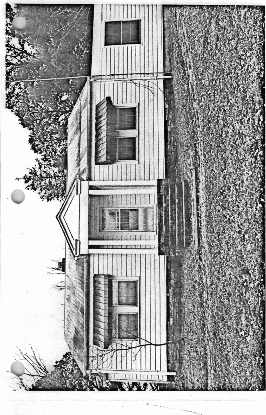
6 Unlted States Department of the Interlor National Park Service National Register of Historic Places Continuation Sheet Seetion number page 1 Description: The Poteau Work Center Residence #2 is located east of Waldron just south of Arkansas Highway 80. Located on the work center punds is a single story structure of frame construction with a rectangular plan and a gable roof. The smcme rests upon a continuous stone foundation, its walls ate covered with novelty siding, and the roof is covered with asphalt shingles. The northern elevation of the house has two sets of six-over-six pane, double hung windows which are covered by metal awnings. The house has one bay central front porch consisting of a set of stone steps and a series of, three columns on the fiont comers of the porch at the erest of the stairs. These columns support a classical pediment with returns which is covered by a gabled roof that intersects midway up the front half of the gabled roof of the main structure. The western elevation of the house is a covered garage which was added to the house. The northern end of this garage is a small utilitylstorage shed. The southern elevation shows a screened porch attached to a rear "L", both of which are covered with a shed type roof which slopes to the south. Inside the screened porch is a single door with a single six-over-six window to its side, The rear "L" has one six-over-six window which is covered by a metal awning. The eastem view shows a gabled side projection as well as the side of the rear "L". The rear T' has another six-over-six window with a metal awning cover and the side projection has a pair of six-over-six windows. This view also shows a single six-over-six window on the main structure. The structure has an interior chimney made of brick which has a placement to the eastem side of center on the southern side of the gabled roof. The building is in excellent condition.

, constihlted the disfrict headquaners for this sizeable district zhat extends")

7 Wnlted States Department of the Interior National Park Service National Register of Historic Places' Continuation Sheet Sectlon number 8 1 Page The Pow Work Cater Residence #2 was conmtsd circa 1939 by memm of the 1707th Compmy of the Arlcansas CCC District stationed al the Waldron Camp tb was located approximately fcmem miles m he east. It was conmwtd as!he residence for the ranger of the Poteau Ranger Dismict of the Ouachita Nasional hat (Ohw. This building, along with the associared work center building (nminazed sepatately), constihlted the disfrict headquaners for this sizeable district zhat extends westward from Arkansas into Oklahoma, and it mtinues to servt that purpose t&y. It is significant for its asmiations with the significant contributions to American mid histmy made by the Civilian Consemtion Corps and for its associations with the conservation movement that President Roosevelt intended this organization to serve, panicularly within such protected federal lands as the national forests.
8

9
/O/U / 013 om NO
 k s ~ i m (Rev. 886) 10900 l\l e L C S ~ /O/U / 013 om NO. 10240018 'Jnited States Department of the Interfor National Park Service NATIONAL REGISTER OF HISTORIC PIACES REGISTRATION FORM B=b 1. Name of
National Register of Historic Places Registration Form
 United States Department of the Interior National Park Service National Register of Historic Places Registration Form This form is for use in nominating or requesting determinations for individual properties
National Register of Historic Places Registration Form
 United States Department of the Interior National Park Service National Register of Historic Places Registration Form This form is for use in nominating or requesting determinations for individual properties
NATIONAL REGISTER OF HISTORIC PLACES REGISTRATION FORM NATIONAL
 /3 NPS Form 10-900 (Rev. 8-86) United States Department of the National Park Service Interior OMB No. 1024-0018 p r [] \^! ^ NATIONAL REGISTER OF HISTORIC PLACES REGISTRATION FORM NATIONAL 1. Name of Property
United States Department of the Interior National Park Service. State Historic Preservation Officer, Texas Historical Commission
 NPS Form 10-900 (Oct. 1990) OMB NO. 10024-0018 United States Department of the Interior National Park Service NATIONAL REGISTER OF HISTORIC PLACES REGISTRATION FORM 1. NAME OF PROPERTY HISTORIC NAME: Lindsay,
Brockschmidt-Miller House Spires, Timothy, House; #359
 NPSFOTH ; C-900 (Rev. 8-8S1 United States Department of the Interior National Park Sen/ice National Register of Historic Places Registration Form FEB 1 6 1990 OMB No. 1024-0018 NATIONAL This form is for
United States Department of the Interior National Park Service National Register of Historic Places Registration Form.
 NPS Fo-m -.C-SOO tr«. S-8«> United States Department of the Interior National Park Service National Register of Historic Places Registration Form 4SJ OMBNa 1024-001S FEB 1 e )gnj This form is tor use in
National Register of Historic Piaces Registration Form
 NPS FoTn '.C-SOO (Rev. 8-86) United States Department of the Interior National Park Sen/ice National Register of Historic Piaces Registration Form NATIONAL REGISTER OMB Na 1024-001S This form is for use
0 buildings public-state. sites public-federal _ structure structures. 1 ~ir~ Total
 NPSFoTn : C -900 lr«v. 8-a
Current Functions (Enter categories from instructions) Materials (Enter categories from instructions)
 Materials (Enter categories from instructions)") Site Inventory Form State Inventory No. 92-00490 New Supplemental State Historical Society of Iowa Part of a district with known boundaries (enter inventory no.) 92-00349 (November 2005) Relationship:
Site Inventory Form State Inventory No. 92-00490 New Supplemental State Historical Society of Iowa Part of a district with known boundaries (enter inventory no.) 92-00349 (November 2005) Relationship:
MAY National Register of Historic Places Registration Form. United States Department of thie interior National Park Service
 NPS FoTTi '.C-9CX} IPm. 6-66) United States Department of thie interior National Park Service National Register of Historic Places Registration Form OMBNa. 10040016 r \ LlLl,,«v n C 1QQ1 ' MAY 0 6 1991
National Register of Historic Places Inventory Nomination Form. 1. Name '' ; 2. Location jf J M COMMERCIAL BUILDINGS IN STILLWATER
 NPS Form 10-900 (3-82) 0MB No. 1024-0018 Exp. 10-31-84 United States Department off the Interior National Park Service National Register of Historic Places Inventory Nomination Form See instructions in
1 'o' Number of contributing resources previously listed in the National Register: N/A
 NPS Form 10-900 (Rev. 8-86) United States Department of the Interior National Park Service NATIONAL REGISTER OF HISTORIC PLACES REGISTRATION FORM OMB No. 1024-0018 FEB 01 1993 NATIONAL B&GISTER 1. NAME
FEB 1 6 LJ. National Register of Historic Places Registration Form. United States Department of the Interior National Parl< Service
 NPS Foin C-900 (R». 6-661 United States Department of the Interior National Parl< Service National Register of Historic Places Registration Form FEB 1 6 LJ OMB No. 1034-0018 NATfOMAL REGISTER This form
State: TX County: Wharton Code: 481 Zip Code: Number of Resources within Property: Contributing Noncontributing. 'o'
 NPS Form 10-900 (Rev. 8-86) United States Department of the Interior National Park Service NATIONAL REGISTER OF HISTORIC PLACES REGISTRATION FORM OMB No. 1024-0018 FEB 01 1993 NATIONAL REGISTER 1. NAME
Current Functions (Enter categories from instructions) 02G04: Commerce/Trade - tavern 14D09: Transportation automotive service
 02G04: Commerce/Trade - tavern 14D09: Transportation automotive service") Site Inventory Form State Inventory No. 29-03500 New Supplemental State Historical Society of Iowa Part of a district with known boundaries (enter inventory no.) 29-03522 (November 2005) Relationship:
Site Inventory Form State Inventory No. 29-03500 New Supplemental State Historical Society of Iowa Part of a district with known boundaries (enter inventory no.) 29-03522 (November 2005) Relationship:
i TE:,Qi"if?inaI o 11 iirgs and uryden
 MAY 2 0 1980 i TE:,Qi"if?inaI o 11 iirgs and uryden ALTERATIONS- interior remodeling 1964 SIGWFICANCE a good southwestern example of Georgian Revival architecture in a planned academic setting AREA OF
Ownership of Property Category of Property Number of Resources within Property X private X building(s) Contributing Noncontributing
 Contributing Noncontributing") NPS FoTn -0-900 (Rev. 8-86) United States Department of the Interior National Park Service National Register of Historic Places Registration Form V60 FEB 1 6 19^3 OMB Na 1024-0018 NATiONAL REGISTER This
NPS FoTn -0-900 (Rev. 8-86) United States Department of the Interior National Park Service National Register of Historic Places Registration Form V60 FEB 1 6 19^3 OMB Na 1024-0018 NATiONAL REGISTER This
Number of Resources within Property buildings
 NPS Foin. C -900 tnn. 6-66) United States Department of the Interior National Park Sen/ice National Register of Historic Places Registration Form i FEB 1 6 --J NATIONAL OMB No. 1024-0018 This form is for
Historic Cultural Properties Inventory (HCPI) Base Form (FORM 1)
 Base Form (FORM 1)") Historic Cultural Properties Inventory (HCPI) Base Form (FORM 1) Historic Preservation Division, New Mexico Office of Cultural Affairs For HPD Office use only: HCPI No. District No. NRHP: SRCP: Criteria:
Historic Cultural Properties Inventory (HCPI) Base Form (FORM 1) Historic Preservation Division, New Mexico Office of Cultural Affairs For HPD Office use only: HCPI No. District No. NRHP: SRCP: Criteria:
Commonwealth of Massachusetts Massachusetts Historical Commission 220 Morrissey Boulevard, Boston, Massachusetts
 Inventory No: Historic Name: Common Name: Address: HRV.166 Hapgood, Shadrach House and Farm Lounger, Stephen N. - Roberts, Walter S. House 150 Ayer Rd City/Town: Village/Neighborhood: Local No: 8-43 Year
Historic Cultural Properties Inventory (HCPI) Base Form (FORM 1)
 Base Form (FORM 1)") Historic Cultural Properties Inventory (HCPI) Base Form (FORM 1) Historic Preservation Division, New Mexico Office of Cultural Affairs For HPD Office use only: HCPI No. District No. NRHP: SRCP: Criteria:
Historic Cultural Properties Inventory (HCPI) Base Form (FORM 1) Historic Preservation Division, New Mexico Office of Cultural Affairs For HPD Office use only: HCPI No. District No. NRHP: SRCP: Criteria:
MAY C C 1S91. United States Department of tiie interior National Parl< Service National Register of Historic Places Registration Form
 NPS Fo-m. C-900 irn. 6-661 United States Department of tiie interior National Parl< Service Registration Form *' OMB No. 1024-0018 MAY C C 1S91 NATIONAL REGISTER This form is for use in nominating or requesting
BLOCK QUAD LOT DATE:_. PERIOD: ownf.r J u l i a Countryman THEME:
 COUNTY CITY BLOCK QUAD NAMP. C o u n t r y m a n H o u s e AnnBFss402 E. 9t.h 23-24 LOT _ rnnntvharris CITY: H O t i S t P n UTM: ARCHITECT/BUILDER:. DATE:_ 1907-08 PERIOD: ownf.r J u l i a Countryman
Appendix: AmaTerra Environmental, Inc. A-1
 Appendix Appendix: Survey Forms AmaTerra Environmental, Inc. A-1 El Camino Real from Oñate Crossing to Misión de Guadalupe A-2 AmaTerra Environmental, Inc. SURVEY AND EVALUATION OF OLD FORT BLISS AT HART
Multiple Family Dwelling House; Single Family Dwelling House
 Inventory No: Historic Name: HRV.50 Patch House Common Name: Address: 20 Fairbank St City/Town: Village/Neighborhood: Center Local No: 17D-54; 262 Year Constructed: R 1750 Architect(s): Architectural Style(s):
C-62 RELATED ACTS. Priv. Acts 1955, Ch. 275, "An Act to redefine the boundaries of the City of Belle Meade... C-63
 C-62 RELATED ACTS Priv. Acts 1955, Ch. 275, "An Act to redefine the boundaries of the City of Belle Meade... C-63 C-63 CHAPTER NO. 275 1 HOUSE BILL NO. 758 (By Davidson Delegation) AN ACT to redefine the
Commonwealth of Massachusetts Massachusetts Historical Commission 220 Morrissey Boulevard, Boston, Massachusetts
 Inventory No: Historic Name: HRV.102 Shaker Tailor Shop Common Name: Address: 88 Shaker Rd City/Town: Village/Neighborhood: Harvard Shaker Village Local No: 5-22; 9; 93; 5-E Year Constructed: Architect(s):
A^^mm. ADDRESS: 1846 Harvard
 COUNTY CITY Q"^P Woman's C l u b 105 BLOCK 25 LOT ADDRESS: 1846 Harvard COUNTY:. H a r r i s ritv- H o u s t o n UTM: ARCHITECT/BUILDER: nu-mfb-hnnston H e i g h t s W o m a n ' s n n h IPAfi u^r-^r^rd
Commonwealth of Massachusetts Massachusetts Historical Commission 220 Morrissey Boulevard, Boston, Massachusetts
 Inventory No: Historic Name: SDW.70 Hamblin, Thomas House Common Name: Address: 246 Rte 6A City/Town: Village/Neighborhood: Sandwich East Sandwich Local No: 67-050 Year Constructed: Architect(s): Architectural
BLOCK QUAD LOT. _ ritv- H o u s t o n UTM:. STYLE:.
 COUNTY CITY NAME ADDRESS: 1421 Harvard ftpruitrrt/riinnfrwm. rtu-mitp. H a r o l d R. 157 BLOCK QUAD A. W i l s o n - b u i l d e r Elsom LOT _ COUNTY:^ H a r r i s _ ritv- H o u s t o n UTM:. natf1905
COLORADO CULTURAL RESOURCE SURVEY Management Data Form Rev. 11/10
 COLORADO CULTURAL RESOURCE SURVEY OAHP1400 Rev. 11/10 A should be completed for each cultural resource recorded during an archaeological survey. Isolated finds and revisits are the exception and they do
[LLAZC X.L EA0000; AZ SRP ] Notice of Temporary Closures: Selected Public Lands in La Paz County, AZ
![[LLAZC X.L EA0000; AZ SRP ] Notice of Temporary Closures: Selected Public Lands in La Paz County, AZ](/thumbs/89/100188672.jpg "[LLAZC X.L EA0000; AZ SRP ] Notice of Temporary Closures: Selected Public Lands in La Paz County, AZ") This document is scheduled to be published in the Federal Register on 12/29/2017 and available online at https://federalregister.gov/d/2017-28217, and on FDsys.gov 4310-32 DEPARTMENT OF THE INTERIOR Bureau
This document is scheduled to be published in the Federal Register on 12/29/2017 and available online at https://federalregister.gov/d/2017-28217, and on FDsys.gov 4310-32 DEPARTMENT OF THE INTERIOR Bureau
[LLAZC03000.L EA0000 LVRCA13SA A, AZ SRP Notice of Temporary Closures of Public Lands in La Paz County, AZ
 This document is scheduled to be published in the Federal Register on 01/15/2013 and available online at http://federalregister.gov/a/2013-00542, and on FDsys.gov 4310-32-P DEPARTMENT OF THE INTERIOR Bureau
EXHIBIT H LOT 317 GRADING AND SITE PLAN
 EXHIBIT H LOT 317 GRADING AND SITE PLAN EXHIBIT I LOT 317 ELEVATIONS ridge height 4915'-6" GENERAL & KEYED NOTES ridge height 4905'-9" 3 7 4 A5.1 1 5 ridge height 4910'-6" 2 ridge height 4906'-3" 1 Provide
D U P L E X D E S I G N G U I D E L I N E S
 PURPOSE As The City Beautiful, Orlando s vision is defined by a focus on its amenities. One of the key elements of that vision is strong urban design. Attention to building design encourages an aesthetically
Commonwealth of Massachusetts Massachusetts Historical Commission 220 Morrissey Boulevard, Boston, Massachusetts
 Inventory No: Historic Name: HRV.2 Harvard Town Hall Common Name: Address: 13 Ayer Rd City/Town: Village/Neighborhood: Local No: Harvard Harvard Center 17D-05; 18; N2 Year Constructed: Architect(s): Architectural
Business Office; Multiple Family Dwelling House; Parsonage; Single Family Dwelling House
 Inventory No: Historic Name: HRV.28 Unitarian Church Parsonage Common Name: Address: 5 Littleton Rd City/Town: Village/Neighborhood: Center Local No: 17D-16; 233 Year Constructed: C 1850 Architect(s):
National Register of Historic Places Inventory Nomination Form
 NPS Form lo-wo-a OMB No. 1024-CX)18 Exp. 10-31-84 United States Department of the Interior National Park Service National Register of Historic Places Inventory Nomination Form NPS UM ortly ved JAN I te
Appendix I-1: Archaeological Records Search
 Appendix I-1: Archaeological Records Search South Central Coastal Information Center California State University, Fullerton Department of Anthropology MH-426 800 North State College Boulevard Fullerton,
OWNER: Mr> vt bwi"^ NHL ]RTHi7. roof: AtP.f^ DATE:-1:11:13 Al: LOT : NAME. COUNTY: CITY:_ ARCH ITECT/BU n npg] P.O.
![OWNER: Mr> vt bwi^ NHL ]RTHi7. roof: AtP.f^ DATE:-1:11:13 Al: LOT : NAME. COUNTY: CITY:_ ARCH ITECT/BU n npg] P.O.](/thumbs/93/114425611.jpg "OWNER: Mr> vt bwi^ NHL ]RTHi7. roof: AtP.f^ DATE:-1:11:13 Al: LOT : NAME. COUNTY: CITY:_ ARCH ITECT/BU n npg] P.O.") COUNTY BLOCK 6AS LOT : NAME COUNTY: CITY:_ PERIOD: -XLL ARCH ITECT/BU n npg] P.O. ei^-f^,r DATE:_ OWNER: Mr> vt bwi"^ THEME:_ STYLE: FYLf \;ic-hvi'ai/\ DESCRIPJION: 1- Sfhrxi P )
COUNTY BLOCK 6AS LOT : NAME COUNTY: CITY:_ PERIOD: -XLL ARCH ITECT/BU n npg] P.O. ei^-f^,r DATE:_ OWNER: Mr> vt bwi"^ THEME:_ STYLE: FYLf \;ic-hvi'ai/\ DESCRIPJION: 1- Sfhrxi P )
APPLICATION TO AMEND THE FUTURE LAND USE MAP (FLUM) SMALL SCALE
 SMALL SCALE") DEPARTMENT OF DEVELOPMENT & PLANNING 825 Ohio Avenue - Lynn Haven, FL 32444 (850) 265-2961 - (850) 265-3478 APPLICATION TO AMEND THE FUTURE LAND USE MAP (FLUM) SMALL SCALE Deadline to submit is 30 days
DEPARTMENT OF DEVELOPMENT & PLANNING 825 Ohio Avenue - Lynn Haven, FL 32444 (850) 265-2961 - (850) 265-3478 APPLICATION TO AMEND THE FUTURE LAND USE MAP (FLUM) SMALL SCALE Deadline to submit is 30 days
BUILDING AND SAFETY FEE SCHEDULE (Effective July1, 2013)
") BUILDING AND SAFETY DIVISION TELEPHONE (949) 724-6300 BUILDING AND SAFETY FEE SCHEDULE (Effective July1, 2013) Payment: When a plan is required by the Administrative Authority to be submitted, a plan check
BUILDING AND SAFETY DIVISION TELEPHONE (949) 724-6300 BUILDING AND SAFETY FEE SCHEDULE (Effective July1, 2013) Payment: When a plan is required by the Administrative Authority to be submitted, a plan check
Engineer's Report. Main Street Business Area. Festoon Lighting and Sidewalk Cleaning Assessment District (Fiscal Year )
") Engineer's Report for the Main Street Business Area Festoon Lighting and Sidewalk Cleaning Assessment District (Fiscal Year 2008-09) Prepared under the provisions of the Benefit Assessment Act of 1982
Engineer's Report for the Main Street Business Area Festoon Lighting and Sidewalk Cleaning Assessment District (Fiscal Year 2008-09) Prepared under the provisions of the Benefit Assessment Act of 1982
Commonwealth of Massachusetts Massachusetts Historical Commission 220 Morrissey Boulevard, Boston, Massachusetts
 Inventory No: Historic Name: HRV.60 Gale and Dickson Store Common Name: Address: 1 Still River Rd City/Town: Village/Neighborhood: Harvard Harvard Center Local No: 17D-02; 53; 31 Year Constructed: Architect(s):
LOT _ COUNTY: _ UTM: PERIOD; STYLE: 530 Harvard Houston. TX 77007
 COUNTY 289 19 BLOCK QUAD NAME:. ADDRFSS- 530 Harvard ARCHITErT/BIin.nF.R:prnh;qhly J o g OWNER: R o s e n d o R u p n t p l l n LOT _ COUNTY: Harris _ ritvhouston _ UTM: n g l p - b l d r P A T F : _ 19Q6-Q7
REZONING GUIDE. Zone Map Amendment (Rezoning) - Application. Rezoning Application Page 1 of 3. Return completed form to
 - Application. Rezoning Application Page 1 of 3. Return completed form to") Zone Map Amendment (Rezoning) - Application COMMUNITY PLANNING & DEVELOPMENT REZONING GUIDE Rezoning Application Page 1 of 3 PROPERTY OWNER INFORMATION* CHECK IF POINT OF CONTACT FOR APPLICATION Property
Zone Map Amendment (Rezoning) - Application COMMUNITY PLANNING & DEVELOPMENT REZONING GUIDE Rezoning Application Page 1 of 3 PROPERTY OWNER INFORMATION* CHECK IF POINT OF CONTACT FOR APPLICATION Property
Proclaiming Certain Lands as Reservation for the Confederated Tribes of the
 This document is scheduled to be published in the Federal Register on 11/05/2018 and available online at https://federalregister.gov/d/2018-24174, and on govinfo.gov [4337-15] DEPARTMENT OF THE INTERIOR
CITY OF PORTLAND, TEXAS SERVICE PLAN FOR ANNEXATION AREA
 CITY OF PORTLAND, TEXAS SERVICE PLAN FOR ANNEXATION AREA Location and Acreage Approximately 1,863 acres of land in San Patricio County, located in the ETJ northwest of the existing City Limits. Metes and
BLOCK QUAD LOT _ COUNTY:. DATE:
 COUNTY CITY NAME. ADDRESS: 301-303 E. 15th LOT _ COUNTY:. Harris _ ritv: Houston _ ARCHITECT/BUILDER: JJ8. p t. 13-14 BLOCK QUAD UTM: DATE:_ STYLE:. THEME: 1 904 PERIOD :- QU'Mirp.Macaria D. Sanchez 301
VILLAGE OF ORLAND PARK
 14700 Ravinia Avenue Orland Park, IL 60462 www.orland-park.il.us Ordinance No: File Number: 2013-0373 AN ORDINANCE ESTABLISHING SPECIAL SERVICE AREA NUMBER 3 STATE OF ILLINOIS, COUNTIES OF COOK AND WILL
Creating A-16 Compliant National Data Theme for Cultural Resources
 Creating A-16 Compliant National Data Theme for Cultural Resources Cultural Resource GIS Facility National Park Service John J. Knoerl Deidre McCarthy Paper 169 Abstract OMB Circular A-16 defines a set
Honorable Mayor and Members of the City Council
 TO: ATTENTION: FROM: SUBJECT: Honorable Mayor and Members of the City Council Jeffrey L. Stewart, City Manager Len Gorecki, Director of Public Works Jerry Stock, City Engineer Public Hearing to Consider
4. Owner of Property. 6. Representation in Existing Surveys. 5. Location of Legal Description
 NPS Form 10-900 United States Department of the Interior N a t i o n a l P a r k S e r v i c e National Register of Historic Places Inventory Nomination Form See instructions in How to Complete National
Notice of Inventory Completion: U.S. Department of Defense, Army Corps of Engineers,
 This document is scheduled to be published in the Federal Register on 06/09/2014 and available online at http://federalregister.gov/a/2014-13414, and on FDsys.gov 4312-50 DEPARTMENT OF THE INTERIOR National
STYLE: THEME: s l i g h t l y arched doorway on second l e v e l i s main entrance^ w i t h.ggtiarpri (rnni-. BUILDING MATERIAL: wau:
 COUNTY CITY MAD MAMF-Tmmanuel L u t h e r a n Church AnnpF«;
THE HISTORY OF WEATHER OBSERVING IN CHEYENNE, WYOMING,
 THE HISTORY OF WEATHER OBSERVING IN CHEYENNE, WYOMING, 1870-2004 Downtown Cheyenne, Wyoming, circa 1890 From Wyoming State Archives, Department of State Parks and Cultural Resources Current as of January
Erosion Information Paper Eagle City and Eagle Village, Alaska Current as of January 21, 2008
 U.S. Army Corps of Engineers ALASKA BASELINE EROSION ASSESSMENT Erosion Information Paper Eagle City and Eagle Village, Alaska Current as of January 21, 2008 Community Information The City of Eagle, population
A. My name is Watsun Randolph and my business address is 45 Horner Street Warrenton
 DIRECT TESTIMONY OF WATSUN RANDOLPH ON BEHALF OF PIEDMONT ENVIRONMENTAL COUNCIL BEFORE THE STATE CORPORATION COMMISSION OF VIRGINIA CASE NOS. PUE-00-000 AND PUE-00-000 0 Q. PLEASE STATE YOUR NAME AND BUSINESS
City of Lockport Historic Resources Survey - Section METHODOLOGY
 2.0 METHODOLOGY Clinton Brown Company PN 07-008 2-1 April 2011 2.0 METHODOLOGY This methodology statement is prepared as part of the project tasks. It outlines the research sources identified, field strategies,
Re: Steep Slope Assessment for 2465 Waverly Drive, Blind Bay, BC; Legal Address: Lot 39, Section 18, Township 22, Range 10, Plan 25579, W6M, KDYD.
 OEL File 1563-1 May 30, 2017 Doug Wall PO Box 774 Salmon Arm, BC V1E 4N7 Re: Steep Slope Assessment for 2465 Waverly Drive, Blind Bay, BC; Legal Address: Lot 39, Section 18, Township 22, Range 10, Plan
NATIONAL REGISTER AMENDMENT Pine Creek Historic District Zion National Park
 NATIONAL REGISTER AMENDMENT Pine Creek Historic District Zion National Park Heritage Conservation Program Drachman Institute College of Architecture & Landscape Architecture The University of Arizona In
SECURITY REGULATED PORT BOUNDARY DESCRIPTION
 SECURITY REGULATED PORT BOUNDARY DESCRIPTION Description of State: Northern Territory Map Number: 68738 The Security Regulated is all of that area of land and water contained within and bounded by a line
Attached you will find files containing information on the sites and surveys we have in our database for the location you requested.
 Attached you will find files containing information on the sites and surveys we have in our database for the location you requested. These files include Microsoft Office Excel spreadsheets with database
 Red River Flooding June 2015 Caddo and Bossier Parishes Presented by: Flood Technical Committee Where the Rain Falls Matters I-30 versus I-20 I-20 Backwater and Tributary Floods (Localized) 2016 Flood
D C P\J C, D CD P\J R
 COMMUNITY PLANNING & DEVELOPMENT DENVER THE MILE HIGH CITY Zone Map Amendment (Rezoning) - Application REZONING GUIDE Rezoning Application Page 1 of 3 PROPERTY OWNER INFORMATION* Property Owner Name Address
Sacramento County Recorder Craig A, Kramer, Clerk/Recorder BOOK PAGE 0708
 I\~ nt"lr'iiaaci\it,.,""'", L...L.. LJ,-/VVIVIL.../Y I Government Code 27383 Oi=r()onlll.ll'::: Oi=()1 Il::CTcn cv I '\,L-"",-,' '-LJII'\,J I ''-\"a(vl..v I L..LJ U r AND WHEN RECORDED RETURN TO: Office
4.3 CULTURAL RESOURCES
 4.3 CULTURAL RESOURCES This section of the EIR analyzes the proposed project s potential impacts on archaeological and paleontological resources. This analysis summarizes the findings of the Archaeological
YELLOWSTONE RIVER FLOOD STUDY REPORT TEXT
 YELLOWSTONE RIVER FLOOD STUDY REPORT TEXT TECHNICAL REPORT Prepared for: City of Livingston 411 East Callender Livingston, MT 59047 Prepared by: Clear Creek Hydrology, Inc. 1627 West Main Street, #294
COPPER RANCH SKETCH PLAN
 SHEET INDEX VICINITY MAP CONTACTS: THE TOWN OF ERIE LAND SUMMARY CHART TYPE AREA (AC.) % OF TOTAL AREA PARKS AND OPEN SPACE SUMMARY (RESIDENTIAL ONLY - 13.5 ACRES/216 UNITS) REQUIRED (ACRES) PROVIDED (ACRES)
Rural Pennsylvania: Where Is It Anyway? A Compendium of the Definitions of Rural and Rationale for Their Use
 Rural Pennsylvania: Where Is It Anyway? A Compendium of the Definitions of Rural and Rationale for Their Use Pennsylvania Office of Rural Health 310 Nursing Sciences Building University Park, PA 16802
Town of Taos Request for Proposal Historic Preservation GIS Geodatabase Project April 2007
 Town of Taos Request for Proposal Historic Preservation GIS Geodatabase Project April 2007 1. Background The Town of Taos is requesting proposals from qualified firms or a team of firms who can develop
IN THE UNITED STATES DISTRICT COURT FOR THE DISTRICT OF COLUMBIA DECLARATION OF TIM MENTZ, SR. IN SUPPORT OF MOTION FOR TEMPORARY RESTRAINING ORDER
 IN THE UNITED STATES DISTRICT COURT FOR THE DISTRICT OF COLUMBIA STANDING ROCK SIOUX TRIBE, Plaintiff, Case No. 1:16-cv-1534-JEB v. U.S. ARMY CORPS OF ENGINEERS, Defendant. DECLARATION OF TIM MENTZ, SR.
OUR TEAM SHEET INDEX CIVIL C O V E R S H E E T. T H E C O V E A T P A C I F I C A S A N J U A N S a n J u a n C a p i s t r a n o, C A
 OUR TEAM SHEET INDEX OWNER/DEVELOPER: PACIFIC POINT DEVELOPMEN PARTNERS LLC CONTACT: MATTHEW LAND 100 SPECTRUM CENTER DR, SUITE 1450 BUSINESS: (949) 341-1237 IRVINE, CA 92618 ARCHITECT / PLANNER: BASSENIAN
APPENDIX I - AREA PLANS
 ROUTE 37 WEST LAND USE PLAN ROUTE 37 WEST LAND USE PLAN Recent land use decisions and development trends have drawn attention to the land within the Route 37 western by-pass area between Route 50 and
Pinellas County Capital Improvement Program, FY2006 Through FY2011 Project Summary Report
 Function : General Government Services Activity : Judicial Project No: 923 Title: Courts/Jails Future Expansion Cost Center: 8160500 Department: General Services Primary Fund: 0401 CIE: No Sub-cost Center:
Sacred Lands File & Native American Contacts List Request
 Sacred Lands File & Native American Contacts List Request NATIVE AMERICAN HERITAGE COMMISSION 915 Capitol Mall, RM 364 Sacramento, CA 95814 (916) 653-4082 (916) 657-5390 Fax nahc@pacbell.net Information
CITY OF PAPILLION PLANNING COMMISSION STAFF REPORT MAY 27, 2015 AGENDA 2015 ANNEXATION MISC
 PLANNING COMMISSION STAFF REPORT MAY 27, 2015 AGENDA 2015 ANNEXATION MISC-15-0005 I. GENERAL INFORMATION A. APPLICANT: City of Papillion 122 East Third St. Papillion, NE 68046 B. LEGAL DESCRIPTION: See
Environmental Analysis, Chapter 4 Consequences, and Mitigation
 Environmental Analysis, Chapter 4 4.17 Environmental Justice This section summarizes the potential impacts described in Chapter 3, Transportation Impacts and Mitigation, and other sections of Chapter 4,
NEWS RELEASE UNDER SECTION 404 OF THE CLEAN WATER ACT (33 USC 1344) ACTION NUMBER SPA ABQ
 ACTION NUMBER SPA ABQ") PUBLIC NOTICE Public Notice Issue Date: //6/07 Albuquerque District Comments due: /6/08 NEWS RELEASE UNDER SECTION 0 OF THE CLEAN WATER ACT ( USC ) ACTION NUMBER SPA-06-00-ABQ BANK STABILIZATION ALONG
PUBLIC NOTICE Public Notice Issue Date: //6/07 Albuquerque District Comments due: /6/08 NEWS RELEASE UNDER SECTION 0 OF THE CLEAN WATER ACT ( USC ) ACTION NUMBER SPA-06-00-ABQ BANK STABILIZATION ALONG
For Sale on Bids. Open House By Appointment
 For Sale on Bids Written Bid Deadline: Friday, September 7, by 12:00 P.M. Noon 52+/- Acres & Storage Facility Grand Forks, ND Property Location: Conveniently located off Interstate 29 and North Washington
The following maps must be provided as a part of the ADA. The appropriate scale for each map should be determined at the pre application conference.
 Main Street @ Coconut Creek DRI QUESTION 9 MAPS The following maps must be provided as a part of the ADA. The appropriate scale for each map should be determined at the pre application conference. Map
Summary of Legal Descriptions
 Perimeter Descriptions Bounds Descriptions - perimeter descriptions without a direction of travel. Metes Descriptions - perimeter descriptions with a direction of travel described by a series of measurements.
APPROVED JURISDICTIONAL DETERMINATION FORM U.S. Army Corps of Engineers
 APPROVED JURISDICTIONAL DETERMINATION FORM U.S. Army Corps of Engineers This form should be completed by following the instructions provided in Section IV of the JD Form Instructional Guidebook. SECTION
TOWN OF SEVERANCE, COLORADO. NOTICE OF PUBLIC HEARINGS FOR A PROJECT Hunters Crossing Annexation & Zoning
 TOWN OF SEVERANCE, COLORADO NOTICE OF PUBLIC HEARINGS FOR A PROJECT Hunters Crossing Annexation & Zoning NOTICE IS HEREBY GIVEN that the Public Hearing required by C.R.S. 31-12-108 before the Severance
PW Parkway ES Prince William County, Virginia WSSI #
 PW Parkway ES Prince William County, Virginia WSSI #15.3 Cultural Resources Site Assessment November 15 Prepared for: Prince William County Public Schools P.O. Box 39 Manassas, Virginia 1 Prepared by:
ENTERGY WHITE BLUFF PLANT RECYCLE POND A AND RECYCLE POND B DEMONSTRATION OF COMPLIANCE WITH EPA CCR RULE SITING CRITERIA 257.
 ENTERGY WHITE BLUFF PLANT RECYCLE POND A AND RECYCLE POND B DEMONSTRATION OF COMPLIANCE WITH EPA CCR RULE SITING CRITERIA 257.62, FAULT AREAS Prepared for Entergy Arkansas, Inc. PO Box 551 Little Rock,
THE HISTORY OF WEATHER OBSERVING IN ATCHISON, KANSAS,
 THE HISTORY OF WEATHER OBSERVING IN ATCHISON, KANSAS, 1865-2004 Current as of January 21, 2005 Prepared by: Stephen R. Doty Information Manufacturing Corporation Rocket Center, West Virginia Prepared in
Trip Generation Study: A 7-Eleven Gas Station with a Convenience Store Land Use Code: 945
 Trip Generation Study: A 7-Eleven Gas Station with a Convenience Store Land Use Code: 945 Introduction The Brigham Young University Institute of Transportation Engineers student chapter (BYU ITE) completed
TOWNSHIP OF SCHUYUULL COUNTY OF SCRUYLMLL RESOLUTIONS ADOPTED 7.9 RESOLUTION
 TOWNSHIP OF SCHUYUULL COUNTY OF SCRUYLMLL RESOLUTIONS ADOPTED 7.9, 1999 RESOLUTION C/9.3, DECLARING ThE INTENT OF THE TOWNSHIP OF SCHUYLKILL THAT THE PORTION OF UMON STREET ADJACENT TO THE PROPERTY OF
BEFORE THE BOARD OF COUNTY COMMISSIONERS OF LANE COUNTY, OREGON
 BEFORE THE BOARD OF COUNTY COMMISSIONERS OF LANE COUNTY, OREGON ORDER NO. 18-04-10-06 IN THE MATTER OF SETTING A PUBLIC HEARING FOR THE PROPOSED SURRENDER OF A PORTION OF COAST GUARD STATION ROAD (COUNTY
5 BUILDINGS ON 15 ACRES AVAILABLE
 INDUSTRIAL 5 BUILDINGS ON 15 ACRES AVAILABLE FOR SALE 1717 W. Park Drive, Huntington, IN 46750 Former Carter Lumber Approximately 38,000 sq. ft. in 5 buildings 15.06 acres with industrial zoning Property
Commonwealth of Massachusetts Massachusetts Historical Commission 220 Morrissey Boulevard, Boston, Massachusetts
 Inventory No: Historic Name: Common Name: Address: SBR238 Smith, Capt Isaac House Newton, Sullivan Ball House 69 Turnpike Rd City/Town: Village/Neighborhood: Southborough Fayville Local No: 38-66 Year
Denis White NSI Technical Services Corporation 200 SW 35th St. Corvallis, Oregon 97333
 POLYGON OVERLAY TO SUPPORT POINT SAMPLE MAPPING: THE NATIONAL RESOURCES INVENTORY Denis White NSI Technical Services Corporation 200 SW 35th St. Corvallis, Oregon 97333 Margaret Maizel ' American Farmland
ADVANCED PLACEMENT HUMAN GEOGRAPHY
 ADVANCED PLACEMENT HUMAN GEOGRAPHY Unit One Geography: Its Nature and Perspectives Session 3 INTERPRETATION OF PLACES AND PATTERNS PLACE: THE GEOGRAPHIC TERM Place is deceptively complex. Place describes
TREASURE COAST REGIONAL PLANNING COUNCIL M E M O R A N D U M. To: Council Members AGENDA ITEM 4B10
 TREASURE COAST REGIONAL PLANNING COUNCIL M E M O R A N D U M To: Council Members AGENDA ITEM 4B10 From: Date: Subject: Staff December 14, 2018 Council Meeting Local Government Comprehensive Plan Review
VILLAGE OF ORLAND PARK
 14700 Ravinia Avenue Orland Park, IL 60462 www.orland-park.il.us Ordinance No: File Number: 2013-0239 AN ORDINANCE PROPOSING THE ESTABLISHMENT OF SPECIAL SERVICE AREA NUMBER 2 IN THE, AND PROVIDING FOR