/O/U / 013 om NO
|
|
|
- Benjamin Maxwell
- 5 years ago
- Views:
Transcription


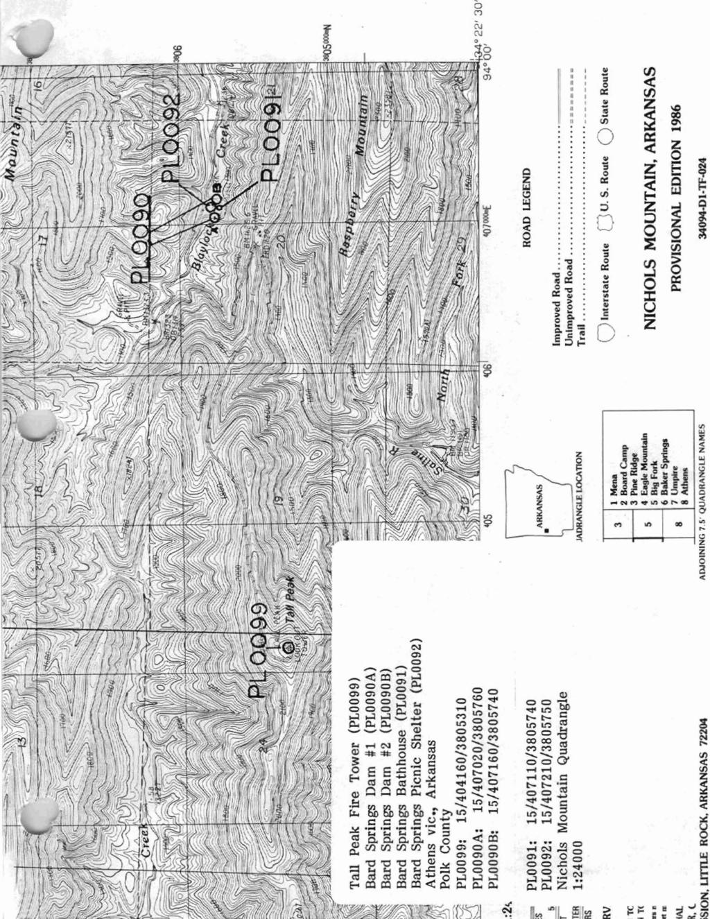
1 k s ~ i m (Rev. 886) l\l e L C S ~ /O/U / 013 om NO 'Jnited States Department of the Interfor National Park Service NATIONAL REGISTER OF HISTORIC PIACES REGISTRATION FORM B=b 1. Name of prom F historic name: Tall Peak Fire Tower other name/skte nmber: PL 0099 street L number: Forest Service Road #38A cityitown: athens not for publication: vicinity: X state: AR county: Polk code: rn 113 zip code: 7197L 3. Classification Ownership of Property: PublicFederal Category of Property: Buildinalsr Number of Resources within Property: contributing Noncontributing buildings sites structures objects 0 Total Number of contributing resources previously listed in the National Register: NIA Name of related multiple property listing: Facilities Constructed bv the ccc in Arkansas,


2 = h t q = > 4. StateJPederal Agency Certification As the designated authority under the National Historic Preservation Act of 1986, as amended, I hereby certify that this nomination request for determination of eligibility meets the documentation standards for registering properties in the National Register of Historic Places and meets the procedural and professional requirements set forth in 36 CFR Part 60. In my opinion, the property meets does not meet the National Register Criteria. See continuation sheet. Signature of certifying official Date State or Federal agency and bureau In my opinion, the property X meets does not meet the National Register criteria. See continuation sheet, Signature of commenting or other official Date 5, National Park Service Certification hereby certify that this property is: entered in the ~ational Regiater See continuation sheet, determined eligible for the National Register See continuation sheet, determined not eligible for the National Register removed from the ~ational ~egister other (explain): ======5 6. Rznction or Use. = = = P = P Signature of Keeper Date of Action En Historic: Other re Tower Sub: N/A Surrent : Vacant/Not in Use Sub: U/A

 : NIA")
3 7, Description =. Architectural CLassificationz other: Rustic Architecture Other ~escription: Materials: foundation Stone roof Ash~alt walls stone other Wood Describe present and historic physical appearance. sheet. See continuation 8. Stabment of Significance. Certifying official has considered the significance of this property in relation to other properties: locallv Applicable National Register Criteria: L C Criteria Considerations (Exceptions) : NIA Areas of Significance: Social Histom Architecture Conservation Significant Dates Significance: : N/A Significant Person(s): N/A Cultural Mf iliation: N/A civilian Conservation Corns State significance of property, and justify criteria, criteria considerations, and areas and periods of significance noted above. X See continuation sheet.
: preliminary determination of individual listing 136 CFR 67) has been requested.")

4 9. Major ~ibliographical References See "Facilities Constructed by the Civilian Conservation Corps in Arkansas, , It Section H. see continuation sheet. Previous documentation an file (NPS): preliminary determination of individual listing 136 CFR 67) has been requested. previously listed in the National Register previously determined eligible by the National Register designated a National Historic Landmark recorded by Historic American Buildings Survey # recorded by Historic American Engineering Record # Primary cation of Additional D aa: State historic presesvation office Other state agency Federal agency lrocal government University Other Specify Repository: 1Q. aphical Data.. Acreage of Property: Jess than one DTM References: Zone Easting Northing Zone Easting Northing See continuation sheet. Verbal Boundary De~cription: See continuation sheet. Beginning at a point on the southern edge of Forest Service Road #38A located approximately 14,000 feet west of Bench Mark , proceed northerly along a line running parallel with the fire tower's western elevation for a distance of 200 feet; thence proceed easterly along a line running parallel with the fire tower's northern elevation for a distance of 200 feet; thence proceed southerly along a line running parallel with the fire tower's eastern elevation for a distance of 200 feet; thence proceed westerly along a line running parallel with the fire tower's southern elevation to the point of beginn kng. Boundary ~ustification: See continuation sheet. This bomdary includes all the property historically associated with this resource, including the fire tower itself and the land surrounding it that was cleared for its constmctian and view of the forest around Tall Peak.


5 =' 21. Form Prepared By Name/Title: Todd Fer o organization:pkansas Historic Presenatfon Promam Date:8/28/91 Street & Numberr225 E. Markham, Suite 300 Telephone:t City or Town: Little Rock State:& ZIP: 72201


6 I United States Department of the Interior National Park Senrice National Register of Historic Places Continuation Sheet Sgetlon numbr Page 1 Description: The Tall Peak Fire Tower is located southeast of Mena on Forest Service Road No. 38A in Polk County. The tower is a two story, field stone and wood structure built on a continuous stone foundation. The first level is made of field stone and each comer has the distinctive inwardsloping corners pecuiiar to CCC construction. The fist level consists of a single room that has two small, stationary windows on the west and south sides and a single door on the east side. The north side of the structure has an external stairway leading to the second level of the sbucture. The second level of.the structure has a porch which extends around the east, south, and west sides of the structure with a plywood balustrade. The second floor has a one room obsentatioa deck which has four windows on each side except on the west side which has three windows and a door. There are no coverings for these windows and no trace of original materid used for the windows. The structure is topped with a pyramidal roof covered with composition shingles. The structure has had some vandalism and some repairs done to it but is in a deteriorated state at present.


7 Unlted States Department of the Interior National Park Service National Register of Historic Places' Continuation Sheet Sectlon number 8 1 page 'Ihc Tall M Fh T m was cmtmtcd circa 1938 by members d the 742nd Company of the AtEEansas CCC District stationed at the Mena Camp hat was located approximately eight miles to the northwest, near the small town of Shady. It war consm~~kd to function as a fire and observation tower to help prevent the fmst fires that heretofore bad ravaged the fmst with devastating effect. As such, the Tall Peak Fire Tower d m significant through its associations with the contributions to hetican socd hismy made by the Civilian Conservation Corps, its associations with the emphasis upon comation of our nanaal resources that was the osighl mandate of the CCC, and its status as an exallenr example of the more functional CCC architecture in a remarkable state of preservation.


8

9
Vnited States D e w t. not for publication: N/A city/town: Waldron. in Arkansas of the Interior. National Park Service
 Vnited States D e w t National Park Service of the Interior WATfONAL REGISTER OF EtS!FORIC PLACES REGISTRATION FORM I, Name of Property - - - -. --- historic name: Poteau Work Center Residence #2 other
National Register of Historic Places Registration Form
 United States Department of the Interior National Park Service National Register of Historic Places Registration Form This form is for use in nominating or requesting determinations for individual properties
National Register of Historic Places Registration Form
 United States Department of the Interior National Park Service National Register of Historic Places Registration Form This form is for use in nominating or requesting determinations for individual properties
NATIONAL REGISTER OF HISTORIC PLACES REGISTRATION FORM NATIONAL
 /3 NPS Form 10-900 (Rev. 8-86) United States Department of the National Park Service Interior OMB No. 1024-0018 p r [] \^! ^ NATIONAL REGISTER OF HISTORIC PLACES REGISTRATION FORM NATIONAL 1. Name of Property
Brockschmidt-Miller House Spires, Timothy, House; #359
 NPSFOTH ; C-900 (Rev. 8-8S1 United States Department of the Interior National Park Sen/ice National Register of Historic Places Registration Form FEB 1 6 1990 OMB No. 1024-0018 NATIONAL This form is for
0 buildings public-state. sites public-federal _ structure structures. 1 ~ir~ Total
 NPSFoTn : C -900 lr«v. 8-a
United States Department of the Interior National Park Service National Register of Historic Places Registration Form.
 NPS Fo-m -.C-SOO tr«. S-8«> United States Department of the Interior National Park Service National Register of Historic Places Registration Form 4SJ OMBNa 1024-001S FEB 1 e )gnj This form is tor use in
United States Department of the Interior National Park Service. State Historic Preservation Officer, Texas Historical Commission
 NPS Form 10-900 (Oct. 1990) OMB NO. 10024-0018 United States Department of the Interior National Park Service NATIONAL REGISTER OF HISTORIC PLACES REGISTRATION FORM 1. NAME OF PROPERTY HISTORIC NAME: Lindsay,
Current Functions (Enter categories from instructions) Materials (Enter categories from instructions)
 Materials (Enter categories from instructions)") Site Inventory Form State Inventory No. 92-00490 New Supplemental State Historical Society of Iowa Part of a district with known boundaries (enter inventory no.) 92-00349 (November 2005) Relationship:
Site Inventory Form State Inventory No. 92-00490 New Supplemental State Historical Society of Iowa Part of a district with known boundaries (enter inventory no.) 92-00349 (November 2005) Relationship:
National Register of Historic Piaces Registration Form
 NPS FoTn '.C-SOO (Rev. 8-86) United States Department of the Interior National Park Sen/ice National Register of Historic Piaces Registration Form NATIONAL REGISTER OMB Na 1024-001S This form is for use
Current Functions (Enter categories from instructions) 02G04: Commerce/Trade - tavern 14D09: Transportation automotive service
 02G04: Commerce/Trade - tavern 14D09: Transportation automotive service") Site Inventory Form State Inventory No. 29-03500 New Supplemental State Historical Society of Iowa Part of a district with known boundaries (enter inventory no.) 29-03522 (November 2005) Relationship:
Site Inventory Form State Inventory No. 29-03500 New Supplemental State Historical Society of Iowa Part of a district with known boundaries (enter inventory no.) 29-03522 (November 2005) Relationship:
National Register of Historic Places Inventory Nomination Form. 1. Name '' ; 2. Location jf J M COMMERCIAL BUILDINGS IN STILLWATER
 NPS Form 10-900 (3-82) 0MB No. 1024-0018 Exp. 10-31-84 United States Department off the Interior National Park Service National Register of Historic Places Inventory Nomination Form See instructions in
Number of Resources within Property buildings
 NPS Foin. C -900 tnn. 6-66) United States Department of the Interior National Park Sen/ice National Register of Historic Places Registration Form i FEB 1 6 --J NATIONAL OMB No. 1024-0018 This form is for
MAY National Register of Historic Places Registration Form. United States Department of thie interior National Park Service
 NPS FoTTi '.C-9CX} IPm. 6-66) United States Department of thie interior National Park Service National Register of Historic Places Registration Form OMBNa. 10040016 r \ LlLl,,«v n C 1QQ1 ' MAY 0 6 1991
State: TX County: Wharton Code: 481 Zip Code: Number of Resources within Property: Contributing Noncontributing. 'o'
 NPS Form 10-900 (Rev. 8-86) United States Department of the Interior National Park Service NATIONAL REGISTER OF HISTORIC PLACES REGISTRATION FORM OMB No. 1024-0018 FEB 01 1993 NATIONAL REGISTER 1. NAME
Historic Cultural Properties Inventory (HCPI) Base Form (FORM 1)
 Base Form (FORM 1)") Historic Cultural Properties Inventory (HCPI) Base Form (FORM 1) Historic Preservation Division, New Mexico Office of Cultural Affairs For HPD Office use only: HCPI No. District No. NRHP: SRCP: Criteria:
Historic Cultural Properties Inventory (HCPI) Base Form (FORM 1) Historic Preservation Division, New Mexico Office of Cultural Affairs For HPD Office use only: HCPI No. District No. NRHP: SRCP: Criteria:
1 'o' Number of contributing resources previously listed in the National Register: N/A
 NPS Form 10-900 (Rev. 8-86) United States Department of the Interior National Park Service NATIONAL REGISTER OF HISTORIC PLACES REGISTRATION FORM OMB No. 1024-0018 FEB 01 1993 NATIONAL B&GISTER 1. NAME
Historic Cultural Properties Inventory (HCPI) Base Form (FORM 1)
 Base Form (FORM 1)") Historic Cultural Properties Inventory (HCPI) Base Form (FORM 1) Historic Preservation Division, New Mexico Office of Cultural Affairs For HPD Office use only: HCPI No. District No. NRHP: SRCP: Criteria:
Historic Cultural Properties Inventory (HCPI) Base Form (FORM 1) Historic Preservation Division, New Mexico Office of Cultural Affairs For HPD Office use only: HCPI No. District No. NRHP: SRCP: Criteria:
i TE:,Qi"if?inaI o 11 iirgs and uryden
 MAY 2 0 1980 i TE:,Qi"if?inaI o 11 iirgs and uryden ALTERATIONS- interior remodeling 1964 SIGWFICANCE a good southwestern example of Georgian Revival architecture in a planned academic setting AREA OF
FEB 1 6 LJ. National Register of Historic Places Registration Form. United States Department of the Interior National Parl< Service
 NPS Foin C-900 (R». 6-661 United States Department of the Interior National Parl< Service National Register of Historic Places Registration Form FEB 1 6 LJ OMB No. 1034-0018 NATfOMAL REGISTER This form
THE HISTORY OF WEATHER OBSERVING IN CHEYENNE, WYOMING,
 THE HISTORY OF WEATHER OBSERVING IN CHEYENNE, WYOMING, 1870-2004 Downtown Cheyenne, Wyoming, circa 1890 From Wyoming State Archives, Department of State Parks and Cultural Resources Current as of January
Historic Cultural Properties Inventory (HCPI) Base Form (FORM 1)
 Base Form (FORM 1)") Historic Cultural Properties Inventory (HCPI) Base Form (FORM 1) Historic Preservation Division, New Mexico Office of Cultural Affairs For HPD Office use only: HCPI No. District No. NRHP: SRCP: Criteria:
Historic Cultural Properties Inventory (HCPI) Base Form (FORM 1) Historic Preservation Division, New Mexico Office of Cultural Affairs For HPD Office use only: HCPI No. District No. NRHP: SRCP: Criteria:
C-62 RELATED ACTS. Priv. Acts 1955, Ch. 275, "An Act to redefine the boundaries of the City of Belle Meade... C-63
 C-62 RELATED ACTS Priv. Acts 1955, Ch. 275, "An Act to redefine the boundaries of the City of Belle Meade... C-63 C-63 CHAPTER NO. 275 1 HOUSE BILL NO. 758 (By Davidson Delegation) AN ACT to redefine the
Historic Cultural Properties Inventory (HCPI) Base Form (FORM 1)
 Base Form (FORM 1)") Historic Cultural Properties Inventory (HCPI) Base Form (FORM 1) Historic Preservation Division, New Mexico Office of Cultural Affairs For HPD Office use only: HCPI No. District No. NRHP: SRCP: Criteria:
Historic Cultural Properties Inventory (HCPI) Base Form (FORM 1) Historic Preservation Division, New Mexico Office of Cultural Affairs For HPD Office use only: HCPI No. District No. NRHP: SRCP: Criteria:
Appendix: AmaTerra Environmental, Inc. A-1
 Appendix Appendix: Survey Forms AmaTerra Environmental, Inc. A-1 El Camino Real from Oñate Crossing to Misión de Guadalupe A-2 AmaTerra Environmental, Inc. SURVEY AND EVALUATION OF OLD FORT BLISS AT HART
TOWN OF SEVERANCE, COLORADO. NOTICE OF PUBLIC HEARINGS FOR A PROJECT Hunters Crossing Annexation & Zoning
 TOWN OF SEVERANCE, COLORADO NOTICE OF PUBLIC HEARINGS FOR A PROJECT Hunters Crossing Annexation & Zoning NOTICE IS HEREBY GIVEN that the Public Hearing required by C.R.S. 31-12-108 before the Severance
CITY OF PAPILLION PLANNING COMMISSION STAFF REPORT MAY 27, 2015 AGENDA 2015 ANNEXATION MISC
 PLANNING COMMISSION STAFF REPORT MAY 27, 2015 AGENDA 2015 ANNEXATION MISC-15-0005 I. GENERAL INFORMATION A. APPLICANT: City of Papillion 122 East Third St. Papillion, NE 68046 B. LEGAL DESCRIPTION: See
[LLAZC03000.L EA0000 LVRCA13SA A, AZ SRP Notice of Temporary Closures of Public Lands in La Paz County, AZ
 This document is scheduled to be published in the Federal Register on 01/15/2013 and available online at http://federalregister.gov/a/2013-00542, and on FDsys.gov 4310-32-P DEPARTMENT OF THE INTERIOR Bureau
Proclaiming Certain Lands as Reservation for the Confederated Tribes of the
 This document is scheduled to be published in the Federal Register on 11/05/2018 and available online at https://federalregister.gov/d/2018-24174, and on govinfo.gov [4337-15] DEPARTMENT OF THE INTERIOR
MAY C C 1S91. United States Department of tiie interior National Parl< Service National Register of Historic Places Registration Form
 NPS Fo-m. C-900 irn. 6-661 United States Department of tiie interior National Parl< Service Registration Form *' OMB No. 1024-0018 MAY C C 1S91 NATIONAL REGISTER This form is for use in nominating or requesting
CITY OF PORTLAND, TEXAS SERVICE PLAN FOR ANNEXATION AREA
 CITY OF PORTLAND, TEXAS SERVICE PLAN FOR ANNEXATION AREA Location and Acreage Approximately 1,863 acres of land in San Patricio County, located in the ETJ northwest of the existing City Limits. Metes and
[LLAZC X.L EA0000; AZ SRP ] Notice of Temporary Closures: Selected Public Lands in La Paz County, AZ
![[LLAZC X.L EA0000; AZ SRP ] Notice of Temporary Closures: Selected Public Lands in La Paz County, AZ](/thumbs/89/100188672.jpg "[LLAZC X.L EA0000; AZ SRP ] Notice of Temporary Closures: Selected Public Lands in La Paz County, AZ") This document is scheduled to be published in the Federal Register on 12/29/2017 and available online at https://federalregister.gov/d/2017-28217, and on FDsys.gov 4310-32 DEPARTMENT OF THE INTERIOR Bureau
This document is scheduled to be published in the Federal Register on 12/29/2017 and available online at https://federalregister.gov/d/2017-28217, and on FDsys.gov 4310-32 DEPARTMENT OF THE INTERIOR Bureau
COLORADO CULTURAL RESOURCE SURVEY Management Data Form Rev. 11/10
 COLORADO CULTURAL RESOURCE SURVEY OAHP1400 Rev. 11/10 A should be completed for each cultural resource recorded during an archaeological survey. Isolated finds and revisits are the exception and they do
Ownership of Property Category of Property Number of Resources within Property X private X building(s) Contributing Noncontributing
 Contributing Noncontributing") NPS FoTn -0-900 (Rev. 8-86) United States Department of the Interior National Park Service National Register of Historic Places Registration Form V60 FEB 1 6 19^3 OMB Na 1024-0018 NATiONAL REGISTER This
NPS FoTn -0-900 (Rev. 8-86) United States Department of the Interior National Park Service National Register of Historic Places Registration Form V60 FEB 1 6 19^3 OMB Na 1024-0018 NATiONAL REGISTER This
Pinellas County Capital Improvement Program, FY2006 Through FY2011 Project Summary Report
 Function : General Government Services Activity : Judicial Project No: 923 Title: Courts/Jails Future Expansion Cost Center: 8160500 Department: General Services Primary Fund: 0401 CIE: No Sub-cost Center:
BLOCK QUAD LOT DATE:_. PERIOD: ownf.r J u l i a Countryman THEME:
 COUNTY CITY BLOCK QUAD NAMP. C o u n t r y m a n H o u s e AnnBFss402 E. 9t.h 23-24 LOT _ rnnntvharris CITY: H O t i S t P n UTM: ARCHITECT/BUILDER:. DATE:_ 1907-08 PERIOD: ownf.r J u l i a Countryman
A. My name is Watsun Randolph and my business address is 45 Horner Street Warrenton
 DIRECT TESTIMONY OF WATSUN RANDOLPH ON BEHALF OF PIEDMONT ENVIRONMENTAL COUNCIL BEFORE THE STATE CORPORATION COMMISSION OF VIRGINIA CASE NOS. PUE-00-000 AND PUE-00-000 0 Q. PLEASE STATE YOUR NAME AND BUSINESS
VILLAGE OF ORLAND PARK
 14700 Ravinia Avenue Orland Park, IL 60462 www.orland-park.il.us Ordinance No: File Number: 2013-0373 AN ORDINANCE ESTABLISHING SPECIAL SERVICE AREA NUMBER 3 STATE OF ILLINOIS, COUNTIES OF COOK AND WILL
Information Paper. Kansas City District. Missouri River Fish and Wildlife Mitigation Project Jim and Olivia Hare Wildlife Area, MO
 City District Information Paper River Fish and Wildlife Mitigation Project Jim and Olivia Hare Wildlife Area, MO Riverine habitat created in 2004/2005 by modifying existing river structures along the banks,
A^^mm. ADDRESS: 1846 Harvard
 COUNTY CITY Q"^P Woman's C l u b 105 BLOCK 25 LOT ADDRESS: 1846 Harvard COUNTY:. H a r r i s ritv- H o u s t o n UTM: ARCHITECT/BUILDER: nu-mfb-hnnston H e i g h t s W o m a n ' s n n h IPAfi u^r-^r^rd
Attachment 1 AUGUST 8, 2018 JOB NO: REAL PROPERTY IN THE CITY OF RIO VISTA, COUNTY OF SOLANO, STATE OF CALIFORNIA, DESCRIBED AS FOLLOWS:
 Attachment 1 EXHIBIT A LEGAL DESCRIPTION 'LIBERTY, PHASE 1' (84 SD 1) CITY OF RIO VISTA, COUNTY OF SOLANO, CALIFORNIA REAL PROPERTY IN THE CITY OF RIO VISTA, COUNTY OF SOLANO, STATE OF CALIFORNIA, DESCRIBED
APPLICATION TO AMEND THE FUTURE LAND USE MAP (FLUM) SMALL SCALE
 SMALL SCALE") DEPARTMENT OF DEVELOPMENT & PLANNING 825 Ohio Avenue - Lynn Haven, FL 32444 (850) 265-2961 - (850) 265-3478 APPLICATION TO AMEND THE FUTURE LAND USE MAP (FLUM) SMALL SCALE Deadline to submit is 30 days
DEPARTMENT OF DEVELOPMENT & PLANNING 825 Ohio Avenue - Lynn Haven, FL 32444 (850) 265-2961 - (850) 265-3478 APPLICATION TO AMEND THE FUTURE LAND USE MAP (FLUM) SMALL SCALE Deadline to submit is 30 days
City of Lockport Historic Resources Survey - Section METHODOLOGY
 2.0 METHODOLOGY Clinton Brown Company PN 07-008 2-1 April 2011 2.0 METHODOLOGY This methodology statement is prepared as part of the project tasks. It outlines the research sources identified, field strategies,
Commonwealth of Massachusetts Massachusetts Historical Commission 220 Morrissey Boulevard, Boston, Massachusetts
 Inventory No: Historic Name: HRV.102 Shaker Tailor Shop Common Name: Address: 88 Shaker Rd City/Town: Village/Neighborhood: Harvard Shaker Village Local No: 5-22; 9; 93; 5-E Year Constructed: Architect(s):
Engineer's Report. Main Street Business Area. Festoon Lighting and Sidewalk Cleaning Assessment District (Fiscal Year )
") Engineer's Report for the Main Street Business Area Festoon Lighting and Sidewalk Cleaning Assessment District (Fiscal Year 2008-09) Prepared under the provisions of the Benefit Assessment Act of 1982
Engineer's Report for the Main Street Business Area Festoon Lighting and Sidewalk Cleaning Assessment District (Fiscal Year 2008-09) Prepared under the provisions of the Benefit Assessment Act of 1982
Appendix I-1: Archaeological Records Search
 Appendix I-1: Archaeological Records Search South Central Coastal Information Center California State University, Fullerton Department of Anthropology MH-426 800 North State College Boulevard Fullerton,
Commonwealth of Massachusetts Massachusetts Historical Commission 220 Morrissey Boulevard, Boston, Massachusetts
 Inventory No: Historic Name: Common Name: Address: HRV.166 Hapgood, Shadrach House and Farm Lounger, Stephen N. - Roberts, Walter S. House 150 Ayer Rd City/Town: Village/Neighborhood: Local No: 8-43 Year
REZONING GUIDE. Zone Map Amendment (Rezoning) - Application. Rezoning Application Page 1 of 3. Return completed form to
 - Application. Rezoning Application Page 1 of 3. Return completed form to") Zone Map Amendment (Rezoning) - Application COMMUNITY PLANNING & DEVELOPMENT REZONING GUIDE Rezoning Application Page 1 of 3 PROPERTY OWNER INFORMATION* CHECK IF POINT OF CONTACT FOR APPLICATION Property
Zone Map Amendment (Rezoning) - Application COMMUNITY PLANNING & DEVELOPMENT REZONING GUIDE Rezoning Application Page 1 of 3 PROPERTY OWNER INFORMATION* CHECK IF POINT OF CONTACT FOR APPLICATION Property
Villages at Riverdale Thornton, CO
 FINAL UTILITY REPORT Villages at Riverdale Thornton, CO October 14, 216 Revised: March 29, 217 JN: 1539 Prepared for: PCS Group, Inc. 11 16 th Street #3 B-18 Denver, CO 8265 P: 33.531.495 Prepared by:
Commonwealth of Massachusetts Massachusetts Historical Commission 220 Morrissey Boulevard, Boston, Massachusetts
 Inventory No: Historic Name: SDW.70 Hamblin, Thomas House Common Name: Address: 246 Rte 6A City/Town: Village/Neighborhood: Sandwich East Sandwich Local No: 67-050 Year Constructed: Architect(s): Architectural
OWNER: Mr> vt bwi"^ NHL ]RTHi7. roof: AtP.f^ DATE:-1:11:13 Al: LOT : NAME. COUNTY: CITY:_ ARCH ITECT/BU n npg] P.O.
![OWNER: Mr> vt bwi^ NHL ]RTHi7. roof: AtP.f^ DATE:-1:11:13 Al: LOT : NAME. COUNTY: CITY:_ ARCH ITECT/BU n npg] P.O.](/thumbs/93/114425611.jpg "OWNER: Mr> vt bwi^ NHL ]RTHi7. roof: AtP.f^ DATE:-1:11:13 Al: LOT : NAME. COUNTY: CITY:_ ARCH ITECT/BU n npg] P.O.") COUNTY BLOCK 6AS LOT : NAME COUNTY: CITY:_ PERIOD: -XLL ARCH ITECT/BU n npg] P.O. ei^-f^,r DATE:_ OWNER: Mr> vt bwi"^ THEME:_ STYLE: FYLf \;ic-hvi'ai/\ DESCRIPJION: 1- Sfhrxi P )
COUNTY BLOCK 6AS LOT : NAME COUNTY: CITY:_ PERIOD: -XLL ARCH ITECT/BU n npg] P.O. ei^-f^,r DATE:_ OWNER: Mr> vt bwi"^ THEME:_ STYLE: FYLf \;ic-hvi'ai/\ DESCRIPJION: 1- Sfhrxi P )
DE PUBLIC SERVICE COMPANY OF NEW HAMPSHIRE
 DE 05-142 PUBLIC SERVICE COMPANY OF NEW HAMPSHIRE Petition for License to Construct and Maintain Electric Lines Over and Across the Public Waters of the Nashua River in the City of Nashua, New Hampshire
Background and Purpose of Meeting. River Towers Meeting. Flood Risk Management Study Alternatives Overview
 1 and Purpose of Meeting River Towers Meeting Flood Risk Management Study Alternatives Overview September 23, 2014 There is no "proposed" flood risk management solution for this area at this time Fairfax
TOWNSHIP OF SCHUYUULL COUNTY OF SCRUYLMLL RESOLUTIONS ADOPTED 7.9 RESOLUTION
 TOWNSHIP OF SCHUYUULL COUNTY OF SCRUYLMLL RESOLUTIONS ADOPTED 7.9, 1999 RESOLUTION C/9.3, DECLARING ThE INTENT OF THE TOWNSHIP OF SCHUYLKILL THAT THE PORTION OF UMON STREET ADJACENT TO THE PROPERTY OF
VILLAGE OF ORLAND PARK
 14700 Ravinia Avenue Orland Park, IL 60462 www.orland-park.il.us Ordinance No: File Number: 2013-0239 AN ORDINANCE PROPOSING THE ESTABLISHMENT OF SPECIAL SERVICE AREA NUMBER 2 IN THE, AND PROVIDING FOR
J.D. Mason, Prof. Engineer. Report on the Reconnaissance Magnetometer Survey. Completed for. North American Platinum Corporation Ltd.
 Report on the Reconnaissance Magnetometer Survey Completed for North American Platinum Corporation Ltd. Olivine Mountain Property, Tulameen, B.C. J.D. Mason, Prof. Engineer. November 28, 1967. Certificate
CHAPTER 5 DOWNTOWN DEVELOPMENT AUTHORITY
 CHAPTER 5 DOWNTOWN DEVELOPMENT AUTHORITY Sec. 5-1. Purposes. Sec. 5-2. Definitions. Sec. 5-3. Determination of Necessity. Sec. 5-4. Establishment; Title. Sec. 5-5. Ordinance approving development plan
PUBLIC UTILITY COMMISSION OF TEXAS DOCKET NO
 Application of CenterPoint Energy Houston Electric, LLC for a Certificate of Convenience and Necessity for a Proposed 138 kv Transmission Line within Harris County, Texas PUBLIC UTILITY COMMISSION OF TEXAS
NOTICE OF PUBLIC HEARING GREEN MEADOWS ANNEXATION (Formally Known as Rude Annexation) (File No. A-17-04)
 (File No. A-17-04)") NOTICE OF PUBLIC HEARING GREEN MEADOWS ANNEXATION (Formally Known as Rude Annexation) (File No. A-17-04) NOTICE IS HEREBY GIVEN that the City Council of Post Falls will hold a public hearing at City Hall,
NOTICE OF PUBLIC HEARING GREEN MEADOWS ANNEXATION (Formally Known as Rude Annexation) (File No. A-17-04) NOTICE IS HEREBY GIVEN that the City Council of Post Falls will hold a public hearing at City Hall,
CONGLETON INDUSTRIAL PARK LT 6 EX W 300' & E 350' LT 7 BLK 1, a subdivision of land in the City of Overland Park, Johnson County, Kansas.
 NOTICE OF PUBLIC HEARING CITY PLANNING COMMISSION CITY OF OVERLAND PARK, KANSAS Notice is hereby given that the City Planning Commission of Overland Park, Kansas, will hold a public hearing Monday, July
SECURITY REGULATED PORT BOUNDARY DESCRIPTION
 SECURITY REGULATED PORT BOUNDARY DESCRIPTION Description of State: Northern Territory Map Number: 68738 The Security Regulated is all of that area of land and water contained within and bounded by a line
Sacramento County Recorder Craig A, Kramer, Clerk/Recorder BOOK PAGE 0708
 I\~ nt"lr'iiaaci\it,.,""'", L...L.. LJ,-/VVIVIL.../Y I Government Code 27383 Oi=r()onlll.ll'::: Oi=()1 Il::CTcn cv I '\,L-"",-,' '-LJII'\,J I ''-\"a(vl..v I L..LJ U r AND WHEN RECORDED RETURN TO: Office
Red River Levee Panel
 Red River Levee Panel Mississippi River Commission Monday, August 9, 2017 Red River Levees in LA & AR NONE along TX & OK Boarder Red River Levee Issues Caddo Levee Cherokee Park Authorization Bossier Levee
TREASURE COAST REGIONAL PLANNING COUNCIL M E M O R A N D U M. To: Council Members AGENDA ITEM 4B10
 TREASURE COAST REGIONAL PLANNING COUNCIL M E M O R A N D U M To: Council Members AGENDA ITEM 4B10 From: Date: Subject: Staff December 14, 2018 Council Meeting Local Government Comprehensive Plan Review
SHADOW STUDY REPORT REGARDING
 SHADOW STUDY REPORT REGARDING an APPLICATION TO REDEVELOP Three 6 Storey Condominiums Regional Road 25 (Ontario Street) and Britannia Road Milton, Ontario KNYMH FILE # 17030 Prepared by: Krista Lilley
WHEREAS, a zoning district map and legaldescription for the subject property are provided in Ordinance Exhibits A and B, respectively; and
 ORDINANCE NO S.907. AN ORDINANCE AMENDING ORDINANCE NO 4441, WHICH ADOPTED THE CITY OF ALBANY ZONING MAP, BY AMENDING THE ALBANY ZONING MAP AND ADOPTING FINDINGS FOR UNADDRESSED PARCELS, LINN COUNTY ASSESSOR'
UTILITY REPORT FOR THORNTON SELF STORAGE THORNTON, COLORADO
 UTILITY REPORT FOR THORNTON SELF STORAGE THORNTON, COLORADO Prepared by: Bowman Consulting 63 Park Point Dr. Suite 1 Golden, CO 841 (33)-81-29 June 29, 215 Revised August 14, 215 Revised September 3, 215
For Sale on Bids. Open House By Appointment
 For Sale on Bids Written Bid Deadline: Friday, September 7, by 12:00 P.M. Noon 52+/- Acres & Storage Facility Grand Forks, ND Property Location: Conveniently located off Interstate 29 and North Washington
EXHIBIT H LOT 317 GRADING AND SITE PLAN
 EXHIBIT H LOT 317 GRADING AND SITE PLAN EXHIBIT I LOT 317 ELEVATIONS ridge height 4915'-6" GENERAL & KEYED NOTES ridge height 4905'-9" 3 7 4 A5.1 1 5 ridge height 4910'-6" 2 ridge height 4906'-3" 1 Provide
BUILDING AND SAFETY FEE SCHEDULE (Effective July1, 2013)
") BUILDING AND SAFETY DIVISION TELEPHONE (949) 724-6300 BUILDING AND SAFETY FEE SCHEDULE (Effective July1, 2013) Payment: When a plan is required by the Administrative Authority to be submitted, a plan check
BUILDING AND SAFETY DIVISION TELEPHONE (949) 724-6300 BUILDING AND SAFETY FEE SCHEDULE (Effective July1, 2013) Payment: When a plan is required by the Administrative Authority to be submitted, a plan check
IN THE UNITED STATES DISTRICT COURT FOR THE DISTRICT OF COLUMBIA DECLARATION OF TIM MENTZ, SR. IN SUPPORT OF MOTION FOR TEMPORARY RESTRAINING ORDER
 IN THE UNITED STATES DISTRICT COURT FOR THE DISTRICT OF COLUMBIA STANDING ROCK SIOUX TRIBE, Plaintiff, Case No. 1:16-cv-1534-JEB v. U.S. ARMY CORPS OF ENGINEERS, Defendant. DECLARATION OF TIM MENTZ, SR.
A GIS TOUR OF DES MOINES PRESENTED BY ANNA WHIPPLE, GIS MANAGER APRIL 20, 2015
 A GIS TOUR OF DES MOINES PRESENTED BY ANNA WHIPPLE, GIS MANAGER APRIL 20, 2015 Welcome to Des Moines! Capital of Iowa Among 100 largest metropolitan areas Insurance, biotech, healthcare, and entertainment
ORDINANCE NO
 ORDINANCE NO. 174421 VAN NUYS CENTRAL BUSINESS DISTRICT COMMUNITY DESIGN OVERLAY PERMANENT [Q] CONDITIONS ORDINANCE An ordinance AMENDING Section 12.04 of the Los Angeles Municipal Code by amending the
Attached you will find files containing information on the sites and surveys we have in our database for the location you requested.
 Attached you will find files containing information on the sites and surveys we have in our database for the location you requested. These files include Microsoft Office Excel spreadsheets with database
THE HISTORY OF WEATHER OBSERVING IN ATCHISON, KANSAS,
 THE HISTORY OF WEATHER OBSERVING IN ATCHISON, KANSAS, 1865-2004 Current as of January 21, 2005 Prepared by: Stephen R. Doty Information Manufacturing Corporation Rocket Center, West Virginia Prepared in
APPROVED JURISDICTIONAL DETERMINATION FORM U.S. Army Corps of Engineers
 APPROVED JURISDICTIONAL DETERMINATION FORM U.S. Army Corps of Engineers This form should be completed by following the instructions provided in Section IV of the JD Form Instructional Guidebook. SECTION
Risk Assessment and Mitigation. Hurricane Checklist
 Risk Assessment and Mitigation Hurricane Checklist Hurricane Checklist Hurricanes are severe tropical storms with sustained winds of at least 74 miles per hour. Hurricane winds can reach 160 miles per
PW Parkway ES Prince William County, Virginia WSSI #
 PW Parkway ES Prince William County, Virginia WSSI #15.3 Cultural Resources Site Assessment November 15 Prepared for: Prince William County Public Schools P.O. Box 39 Manassas, Virginia 1 Prepared by:
BEFORE THE BOARD OF COUNTY COMMISSIONERS OF LANE COUNTY, OREGON
 BEFORE THE BOARD OF COUNTY COMMISSIONERS OF LANE COUNTY, OREGON ORDER NO. 18-04-10-06 IN THE MATTER OF SETTING A PUBLIC HEARING FOR THE PROPOSED SURRENDER OF A PORTION OF COAST GUARD STATION ROAD (COUNTY
Summary of Legal Descriptions
 Perimeter Descriptions Bounds Descriptions - perimeter descriptions without a direction of travel. Metes Descriptions - perimeter descriptions with a direction of travel described by a series of measurements.
 Red River Flooding June 2015 Caddo and Bossier Parishes Presented by: Flood Technical Committee Where the Rain Falls Matters I-30 versus I-20 I-20 Backwater and Tributary Floods (Localized) 2016 Flood
One of the tasks of the Floods Study Team was to determine if any new facilities
 8. Development and Enhancement of Interpretive Facilities One of the tasks of the Floods Study Team was to determine if any new facilities would be needed to help interpret the Floods story, or if any
D C P\J C, D CD P\J R
 COMMUNITY PLANNING & DEVELOPMENT DENVER THE MILE HIGH CITY Zone Map Amendment (Rezoning) - Application REZONING GUIDE Rezoning Application Page 1 of 3 PROPERTY OWNER INFORMATION* Property Owner Name Address
P r O P e r t y L I S T I N G. 701 Fifth Avenue, Seattle. The Most Prominent Building in the Seattle Skyline JOHN HANSEN.
 701 Fifth Avenue, Seattle The Most Prominent Building in the Seattle Skyline F e A T u r e s At 76 stories high, this skyscraper boasts unparalleled 360 degree views of Puget Sound, the Olympic Mountains,
4.3 CULTURAL RESOURCES
 4.3 CULTURAL RESOURCES This section of the EIR analyzes the proposed project s potential impacts on archaeological and paleontological resources. This analysis summarizes the findings of the Archaeological
Jason Bentley Ashe Prelim_Research_Notebook_Data MDS_I Fall_2007
 Jason Bentley Ashe Prelim_Research_Notebook_Data MDS_I Fall_2007 Theory Section: This section will be coming very soon, due to the change in my project. Quotes: Explanation: Application to your Thesis
2018 North Carolina Residential Code Prescriptive Tables for Selection of Support Elements for Beams, Girders, and Headers: Example Problems
 2018 North Carolina Residential Code Prescriptive Tables for Selection of Support Elements for Beams, Girders, and Structural Building Components Association (SBCA) August 10, 2018 SBCA is an APPROVED
WHITEHEAD 30 (10) (570) (30) (10) & TRACY MILLER.
 (570) (30) (10) & TRACY MILLER.") BEGINNING at a point in the center of Pennsylvania State Highway Route No. 414, said point located on the boundary between the lands herein described and lands now or formerly of Carman Tartaglia; thence
BEGINNING at a point in the center of Pennsylvania State Highway Route No. 414, said point located on the boundary between the lands herein described and lands now or formerly of Carman Tartaglia; thence
ADDITIONAL PHASE IA ARCHAEOLOGICAL SURVEY FOR THE UMORE PARK SAND AND GRAVEL MINING ENVIRONMENTAL REVIEW SERVICES, DAKOTA COUNTY, MINNESOTA
 ADDITIONAL PHASE IA ARCHAEOLOGICAL SURVEY FOR THE UMORE PARK SAND AND GRAVEL MINING ENVIRONMENTAL REVIEW SERVICES, DAKOTA COUNTY, MINNESOTA ADDENDUM I Submitted to: Short Elliot Hendrickson, Inc. Submitted
Sacred Lands File & Native American Contacts List Request
 Sacred Lands File & Native American Contacts List Request NATIVE AMERICAN HERITAGE COMMISSION 915 Capitol Mall, RM 364 Sacramento, CA 95814 (916) 653-4082 (916) 657-5390 Fax nahc@pacbell.net Information
Multiple Family Dwelling House; Single Family Dwelling House
 Inventory No: Historic Name: HRV.50 Patch House Common Name: Address: 20 Fairbank St City/Town: Village/Neighborhood: Center Local No: 17D-54; 262 Year Constructed: R 1750 Architect(s): Architectural Style(s):
ATTACHMENT A. Item #1 Minimum Bid: $3, Parcel No Assessed Value: $10,000 Acreage: 0
 ATTACHMENT A Item #1 Minimum Bid: $3,634.59 Parcel No. 0610540500 Assessed Value: $10,000 Acreage: 0 Lots 5 and 6, Block 54, Town of Coulee Dam, Washington, according to the Second Revised Okanogan County
BEFORE THE BOARD OF COUNTY COMMISSIONERS OF LANE COUNTY, OREGON
 BEFORE THE BOARD OF COUNTY COMMISSIONERS OF LANE COUNTY, OREGON ORDER NO. 18-05-22-06 IN THE MATTER OF SURRENDER OF A PORTION OF COAST GUARD STATION ROAD (COUNTY ROAD NUMBER 65) AND A PORTION OF S. HARBOR
Environmental Analysis, Chapter 4 Consequences, and Mitigation
 Environmental Analysis, Chapter 4 4.17 Environmental Justice This section summarizes the potential impacts described in Chapter 3, Transportation Impacts and Mitigation, and other sections of Chapter 4,
SOUTHEAST PLANT POWER FEED AND PRIMARY SWITCHGEAR UPGRADES CIVIC DESIGN REVIEW - PHASE 1 - NOVEMBER 14, 2016
 SOUTHEAST PLANT POWER FEED AND PRIMARY SWITCHGEAR UPGRADES CIVIC DESIGN REVIEW - PHASE 1 - NOVEMBER 14, 2016 CITY & COUNTY OF SAN FRANCISCO PUBLIC UTILITIES COMMISSION PROJECT LOCATION CALTRAIN RAILROAD
73-2 have been satisfied; and
 RESOLUTION NO. R- 86-104 W'dEREAS, the Board of County Commissioners, as the governing body, pursuant to the authority vested in Chapter 163 and Chapter 125, Florida Statutes, is authorized and empowered
THE TRINITY RIVER VISION/ GATEWAY PARK / PANTHER ISLAND Flood Control Project Update
 Quarterly Project Status Report September 2018 THE TRINITY RIVER VISION/ GATEWAY PARK / PANTHER ISLAND Flood Control Project Update TxDot s contractor has nearly completed the superstructure false work
River Realty Services Commercial
 1 4 6 N O R T H U S 9 W, C O N G E R S, N Y 1 0 9 2 0 TA B L E O F C O N T E N T S E X E C U T I V E S U M M A RY 03 Z O N I N G 09 R EG I S T R AT I O N S 04 S U B J EC T P H OTO S 10 M A P V I E W 05
Rural Pennsylvania: Where Is It Anyway? A Compendium of the Definitions of Rural and Rationale for Their Use
 Rural Pennsylvania: Where Is It Anyway? A Compendium of the Definitions of Rural and Rationale for Their Use Pennsylvania Office of Rural Health 310 Nursing Sciences Building University Park, PA 16802
The following maps must be provided as a part of the ADA. The appropriate scale for each map should be determined at the pre application conference.
 Main Street @ Coconut Creek DRI QUESTION 9 MAPS The following maps must be provided as a part of the ADA. The appropriate scale for each map should be determined at the pre application conference. Map