A Tale of Two Cities Students listen to and discuss a story about two contrasting cities in California (Mount Shasta. Lesson 1
|
|
|
- Rosa Pearson
- 5 years ago
- Views:
Transcription


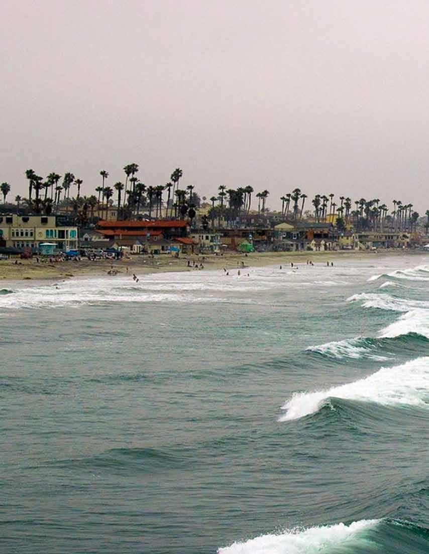
1 Lesson 1 Southern California beach A Tale of Two Cities Students listen to and discuss a story about two contrasting cities in California (Mount Shasta City and Oceanside) and ways in which people s lives differ in the two locations. Students develop tables outlining some of the human characteristics of each location. Students then describe, through drawings and in written format, the kind of place where they would like to live, and they explain their choice in relation to location, weather, and physical environment. Contrasting two different locations and comparing how people live in these locations help students appreciate the environmental factors that create specific conditions which influence people s choices about clothing, shelter, transportation, and recreation. These activities and the concepts they present deepen student appreciation of the underlying connection between people and the natural environment. This theme is further developed in follow-up lessons, where students analyze how both natural events and human activities can change natural systems, and how these changes can affect how people live. 30 CALIFORNIA EDUCATION AND THE ENVIRONMENT INITIATIVE I Unit I People and Places


2 Lesson 1 People and Places Learning Objective Describe how location, weather, and the physical environment interact to create specific conditions that determine what humans use for food, clothing, shelter, transportation, and recreation. Background The location and natural features of a place play significant roles in determining climate and weather conditions. California offers contrasting landscapes and diverse topography. These contrasts can be easily observed along the coastline, where the Coast Ranges rise from the shore in steep cliffs and terraces. In the southern part of the state, wide, sandy beaches are more typical. The Coast Ranges include many smaller mountain ranges with valleys Fishing separating them. Also located in the Coast Ranges are the coast redwoods (Sequoia sempervirens) and the San Andreas Fault. The highest temperature recorded in California is 134 F (57 Celsius); the lowest, -45 F (-43 C). The climate throughout the state is varied. Along the coast, the climate tends to be mild. The central and northern coastal areas are usually cooler, while southeastern California is hot and dry. Most of California has only two distinct seasons; a rainy season and a dry season. Mount Shasta City is located in the northern part of California, on the southwest slopes of Mount Shasta. The area is a popular destination for tourists, as it offers a wide variety of recreational activities, including trout fishing in the nearby rivers, and hiking, climbing, and skiing in the mountains. Mount Shasta City gets more precipitation than the semi arid region to the north. Over the winter, it gets an average of 104 inches (264 centimeters) of snowfall, despite its low (3,600-foot or 1,097-meter) elevation. To the East of the city, Mount Shasta forces moisture out of the air as it ascends and cools. Oceanside is a beachfront community located on the Pacific Coast in the southern part of California. The mainstays of the Oceanside economy have been tourism and the proximity of Camp Pendleton, a large military base. Manufacturing in the area also includes a variety of sporting and recreational goods, as well as biotech and med-tech products. Agriculture, too, is important to Oceanside s economy. The warm climate of Oceanside supports the growth of tomatoes, avocados, citrus fruit, and plants sold in nurseries. Key Vocabulary Coast: The area along the shores of oceans and bays. Inland: Areas away from the coast of the ocean or the shore of a lake. Recreation: Things people do for fun, like camping. Transportation: The act of moving people or things from one place to another. CALIFORNIA EDUCATION AND THE ENVIRONMENT INITIATIVE I Unit I People and Places 31
3 Toolbox Prerequisite Knowledge Advanced Preparation Summary of Activities Students listen to and discuss a story about contrasting California cities and how people live in each. Students gather information from a map about places in California. They describe where they live in terms of location, weather, and physical environment. Instructional Support See Extensions & Unit Resources, pages Students should know about: characteristics of mountains, rivers, oceans, valleys, deserts, and local landforms. Students should be able to: describe common objects and events in both general and specific language. Gather and prepare Materials Needed. Gather and prepare A-V Materials: Wall Maps Post the People and the Environment and Political wall maps side-by-side in a location visible to all students. Begin a Word Wall: Prepare a wall or bulletin board in the classroom on which to post the vocabulary Word Wall Cards. Make Life in Mount Shasta City and Life in Oceanside Charts: On chart paper or the board, make a Life in Mount Shasta City Chart and Life in Oceanside Chart based on the samples provided below Step 4 in Session 1, and Step 2 in Session 2, respectively. 32 CALIFORNIA EDUCATION AND THE ENVIRONMENT INITIATIVE I Unit I People and Places

4 Lesson 1 People and Places Materials Needed Audio-Visual Materials Duration Activity Supplies: sticky notes: 3" x 3" Big Book: California Connections: Two Different Places, provided separately Class Supplies: chart paper colored markers pencils tape or thumbtacks Dictionary Workbook: provided separately Student Workbook: Where I Live, pages 2 3 Word Wall Cards: provided separately Wall Maps: People and the Environment, provided separately Political, provided separately Preparation Time 20 min. Instructional Time Session 1-30 min. Session 2-30 min. Safety Notes None CALIFORNIA EDUCATION AND THE ENVIRONMENT INITIATIVE I Unit I People and Places 33
5 Procedures Vocabulary Development Use the Dictionary Workbook and the vocabulary Word Wall Cards to introduce new words to students as appropriate. Ask students to write their name in the space provided in the dictionary. These documents are provided separately. Session 1 Step 1 Show the title on the front cover of California Connections: Two Different Places. Tell students that this book is about two different places with different natural environments in California and about the people who live in these places. Say to the students, Look at the picture on the front cover. What do you see? Prompt students to use descriptive words by asking for more specific details. Ask students, How are these two places different? (The weather is different; there are different kinds of trees.) Step 2 Call attention to the People and the Environment and Political wall maps. Point to an inland, mountainous area in northern California and a coastal area in the Southern California. Ask students, What are some ways in which these two places may be different? (One is in the mountains and may have lots of trees. One is by the ocean and may have a sandy beach.) Using the Political wall map as a reference, locate and mark the locations of the cities of Oceanside and Mount Shasta (the city) on the People and the Environment wall map with sticky notes. Tell students that they are now going to read about what life is like in these two areas. Step 3 Read Part One of California Connections: Two Different Places aloud to students. Have students describe something about the natural environment around Mount Shasta City. Prompt them to use descriptive words. (It has very high mountains, lots of tall evergreen trees, and a very large lake.) Have students describe something about the weather in Mount Shasta City. (It is cold and snowy in the winter.) Step 4 Call students attention to the Life in Mount Shasta City Chart. Have students use information presented in the text and photographs of California Connections: Two Different Places to fill in the columns of the chart with words and phrases. (Note: Sample Answers have been provided in the chart below.) Life in Mount Shasta City Chart Food Clothes Transportation Homes Recreation Peaches Plums Nuts Tomatoes Blackberries Fish Winter coats Gloves Winter hats Jeans Buses Cars Trucks Tractors Fireplace Camping Fishing Skiing Hiking 34 CALIFORNIA EDUCATION AND THE ENVIRONMENT INITIATIVE I Unit I People and Places
6 Lesson 1 People and Places Session 2 Step 1 Remind students that in the last session they learned about what life was like for people living in a city in the northern part of California. Ask students to name the city they learned about. (Mount Shasta City) Read Part Two of California Connections: Two Different Places aloud to students. Have students describe something about the natural environment around Oceanside. Prompt them to use descriptive words. (It is by the ocean and has a very large sandy beach. It has a long wooden pier that reaches far out into the ocean.) Have students describe the kind of weather Oceanside has. (It is sunny and warm all year.) Step 2 Call students attention to the Life in Oceanside Chart. Have students use information presented in the text and photographs of California Connections: Two Different Places to fill in the columns on the chart with words and phrases. (Note: Sample Answers are provided on the chart below.) Life in Oceanside Chart Food Clothes Transportation Homes Recreation Ice cream Fish Strawberries Dates Avocados Sunglasses Swimsuits Straw hats Sandals Shorts City buses Cars Trucks Walking Swimming pool Apartments Fishing Swimming Surfing Having picnics Whale watching Fireworks Step 3 Compare the two charts. Encourage students to notice what makes these two places the same. (People, eat fruit, use buses and cars to get around, and fish for recreation.) Ask them to describe what makes them different. (One is cold, the other warm. One is rural, the other urban.) Step 4 Distribute a Student Workbook to each student. Tell students to turn to Where I Live (Student Workbook, pages 2 3). Read the instructions and allow 10 minutes for students to complete the work independently. Collect Student Workbooks and use Where I Live for assessment. CALIFORNIA EDUCATION AND THE ENVIRONMENT INITIATIVE I Unit I People and Places 35
7 Lesson Assessment Description Where I Live (Student Workbook, pages 2 3) assesses students achievement of the learning objective: Describe how location, weather, and the physical environment interact to create specific conditions that determine what humans use for food, clothing, shelter, transportation, and recreation. To demonstrate what they have learned, students make a drawing and complete several sentences. Suggested Scoring An Answer Key and Sample Answers for Where I Live are provided on pages The drawing is worth five points and each correct sentence completion is worth 2 points. There are 15 total points possible. 36 CALIFORNIA EDUCATION AND THE ENVIRONMENT INITIATIVE I Unit I People and Places
8 Lesson 1 People and Places Answer Key and Sample Answers Where I Live Lesson_1 page 1 of 2 Name: Instructions: Draw_a_picture_of_where_you_live._Label_the_parts._ (5_points) Students drawings could include many different things: a beach, a mountain, a river, a city park. CALIFORNIA EDUCATION AND THE ENVIRONMENT INITIATIVE I Unit I People and Places 37
9 Answer Key and Sample Answers Where I Live Lesson_1 page 2 of 2 Name: Instructions: Fill_in_the_blanks_to_complete_each_sentence. (2_points_each) 1._Where_I_live_the_weather_is_ Answer will appropriately reflect the usual weather where the student lives (hot, cold, windy, snowy, rainy). 2._Where_I_live,_we_wear_. Answer will appropriately reflect the usual clothing where the student lives (shorts, tank tops, sweaters, scarves, flip flops, boots). 3._Where_I_live,_we_use_ for_transportation._ Answer will appropriately reflect the available transportation where the student lives (buses, cars, trucks, tractors, trolley, boat). 4._I_live_in_a_ Answer will appropriately reflect the usual shelters where the student lives (apartment with swimming pool, house with fireplace). 5._Where_I_live,_we.. _for_fun._ Answer will appropriately reflect the usual recreational activities where the student lives (horseback ride, swim, hike, fly kites, watch fireworks)..._ 38 CALIFORNIA EDUCATION AND THE ENVIRONMENT INITIATIVE I Unit I People and Places
10
 surrounding urban areas.")
11 Lesson 2 Mountain homes near Mount Shasta City Where People Live Students use a map to locate prominent physical features of California (such as oceans, mountains, and lakes) and to identify some of the physical features (such as forests, farmland, and bodies of water) surrounding urban areas. They gather information from text and pictures about the history of California Indians and other settlers in the Mount Shasta City and Oceanside areas. They list some of the natural resources used by the areas early people for activities such as hunting, gathering, farming, and fishing. As a concluding activity, students draw a picture and complete related sentences demonstrating their understanding that human communities are often located in close proximity to the natural systems that provide the ecosystem goods and ecosystem services upon which humans depend. These activities reinforce concepts relating to humans use of, and dependence on, natural systems and prepare students for following lessons on how changes to natural systems can affect how people live. 40 CALIFORNIA EDUCATION AND THE ENVIRONMENT INITIATIVE I Unit I People and Places


12 Lesson 2 People and Places Learning Objective Recognize that human communities are generally located in close proximity to the natural systems (for example, forests, farmland, bodies of water) that provide the goods and ecosystem services upon which humans depend. Background The Okwanuchu tribe once occupied the site of Mount Shasta City. They lived in small villages, in homes made of planks built partially underground. Their food was gathered primarily from plants, with acorns, seeds, and roots, making up most of their diet. Fish, particularly salmon, was also an important part of their food supply. The Okwanuchu tribe first came in contact with people of European descent when fur traders, early in the 19th century, trapped in their territory. Soon after, gold mining prospects brought many other non-indian people to the area. Later, lumber mills, a stagecoach road, a hotel, and the arrival of the railroad brought more people to Mount Shasta. Tourism and lumbering continue to play a critical role in the economy of Mount Shasta. The Pechanga Band of Luiseño Indians once occupied the site of Oceanside. The staple food of the Luiseños was acorns, but during winter and spring, when numerous annual plants were available, many greens were also eaten. Additionally, the seeds of many plants were used for food, along with a variety of fruits and berries. Luiseño people call themselves Payomkowishum, meaning People of the West. The name Luiseño was given to the tribe by the Spanish because of their proximity to the Mission San Luís Rey de Francia. A small town grew up around the mission in the San Luis Rey Valley, and going to the ocean side soon became a popular weekend retreat for rancho (agricultural) families living in the warmer inland areas. The first pilings for the construction of a wooden pier in Oceanside were driven in Shortly after, the wharf was destroyed by a storm. Over the years, other piers were built, lost to storms, and rebuilt. The current Oceanside Pier is the longest wooden pier on the western United States coastline. The harbor, which continues to attract many tourists, is used extensively for both pleasure and sport-fishing boats. Key Vocabulary Farming: Raising crops or animals or both. Natural resources: Things plants and animals, including humans, use from nature such as water, wood, and soil. Urban: Related to a city. Oceanside Pier CALIFORNIA EDUCATION AND THE ENVIRONMENT INITIATIVE I Unit I People and Places 41

13 Toolbox Prerequisite Knowledge Advanced Preparation Summary of Activities Students use information from a map and photographs to discover that human communities are often located in close proximity to certain natural features and resources. Students identify some of the ecosystem goods and services provided by natural systems and used by humans in California. Students should know about: how people lived in earlier times and how their lives would be different today. characteristics of mountains, rivers, oceans, valleys, deserts, and local landforms. resources from earth and how they are used by people. Students should be able to: distinguish between land and water on maps. Gather and prepare Materials Needed. Gather and prepare A-V Materials: Wall Maps: Post the People and the Environment wall map in a location visible to all students. Add new vocabulary to Word Wall. Instructional Support See Extensions & Unit Resources, pages CALIFORNIA EDUCATION AND THE ENVIRONMENT INITIATIVE I Unit I People and Places
14 Lesson 2 People and Places Materials Needed Audio-Visual Materials Duration Activity Supplies: acorns (optional) clay soil (optional) ice (shaved or powdered, if possible) or snow pine cones, needles, bark, or wood (optional) rock (optional) sand (optional) A-V Equipment: projection system, screen Class Supplies: pencils Student Workbook: Where People Live, pages 4 5 Visual Aids: California Indians at Mount Shasta, Visual Aid #1 Logging at Mount Shasta, Visual Aid #2 Mining Near Mount Shasta, Visual Aid #3 Farming Near Mount Shasta, Visual Aid #4 California Indians Near Oceanside, Visual Aid #5 Farming and Ranching Near Oceanside, Visual Aid #6 Enjoying the Beach Near Oceanside, Visual Aid #7 San Luis Rey Mission Near Oceanside, Visual Aid #8 Preparation Time 15 min. (longer if acquiring optional activity supplies) Instructional Time 45 min. Safety Notes None CALIFORNIA EDUCATION AND THE ENVIRONMENT INITIATIVE I Unit I People and Places 43
15 Procedures Vocabulary Development Use the Dictionary Workbook and the vocabulary Word Wall Cards to introduce new words to students as appropriate. Step 1 Introduce the vocabulary word urban and point to and name some of the major urban areas on the People and the Environment wall map (Sacramento, San Francisco, Fresno, Los Angeles, San Diego, and Redding). Call on individual students to identify an ecosystem close to each of these urban areas. (There are rivers by Sacramento and Fresno; ocean and coast by San Francisco and Los Angeles; ocean and a river by San Diego; and mountains and a river by Redding.) Remind students that historically many people in California lived in areas that were more natural than they are today. They were able to live there and use the goods and services offered by the environment. Ask: How could they use the ocean, the forests, and the rivers? (Food could come from the oceans and rivers; they could get logs from the forests; the ocean and rivers could be used for shipping.) Step 2 Using the People and the Environment wall map, point to the places where Mount Shasta City and Oceanside are located. Have students identify some of the ecosystems close to each of these cities. (Mount Shasta City has mountains, lakes, and forests. Oceanside has the ocean and coast.) Ask students to recall (from Lesson 1) and name some of the ways people use these natural environments. (We go fishing, camping, and surfing.) If not identified by the students, point out that close to each of these areas is land used for agriculture (farming and ranching) and that near Mount Shasta City there are forests which people use for logging. Step 3 Project California Indians at Mount Shasta, Logging at Mount Shasta, Mining Near Mount Shasta, and Farming Near Mount Shasta (Visual Aids #1 4). Explain that these photographs give information about the Mount Shasta area in earlier times. Read aloud the text accompanying each visual aid. If acquired, distribute or display the clay soil, rock, ice, and pine cones, needles, bark or wood for students to view and feel. Tell students that many of the natural resources used by people who once lived in or near Mount Shasta are still used by people that live there today. (People use land for farming. People picked berries and nuts. People use trees for lumber.) Step 4 Project California Indians Near Oceanside, Farming and Ranching Near Oceanside, Enjoying the Beach Near Oceanside, and San Luis Rey Mission Near Oceanside (Visual Aids #5 8). Explain that these photographs give information about the city of Oceanside in earlier times. Read aloud the text accompanying each visual aid. If acquired, pass a few acorns and some clay around for students to view and feel. Have students list some of the natural resources used by people who lived in or near Oceanside in earlier times. (The people took acorns and berries for food. People used soil and land for farming. They used clay and stone for buildings.) Step 5 Redistribute the students individual Student Workbooks. Tell them to turn to Where People Live (Student Workbook, pages 4 5). Review the instructions and read the words in the Word Bank, and each of the questions to the students. Tell them to use the People and the Environment wall map to find some of the answers. Collect Student Workbooks and use Where People Live in assessment. 44 CALIFORNIA EDUCATION AND THE ENVIRONMENT INITIATIVE I Unit I People and Places
 that provide the goods and ecosystem services upon which humans depend.")
16 Lesson 2 People and Places Lesson Assessment Description Where People Live (Student Workbook, pages 4 5) assesses students achievement of the learning objective: Recognize that human communities are generally located in close proximity to the natural systems (for example, forests, farmland, bodies of water) that provide the goods and ecosystem services upon which humans depend. To demonstrate what they have learned, students complete sentences using a word bank, and draw a picture. Suggested Scoring An Answer Key and Sample Answers for Where People Live are provided on pages There are 12 total points possible. CALIFORNIA EDUCATION AND THE ENVIRONMENT INITIATIVE I Unit I People and Places 45
17 Answer Key and Sample Answers Where People Live Lesson_2 page 1 of 2_ Instructions:_Use_words_from_the_Word_Bank_to_fill_in_the_ answers_below._(2_points_each) Word Bank Name: _ coast_ mountain_ forest wood _ fish_ river_ land 1._Oceanside_is_a_city_on_the_ coast._ 2._The_city_of_Sacramento_is_near_a_ river. 3._People_that_live_near_the_ocean_or_a_river_can_get_ fish _from_the_water. 4._People_that_live_near_forests_can_get_ from_the_trees. wood _ 5._Farmers_need_ land _to_grow_food. 46 CALIFORNIA EDUCATION AND THE ENVIRONMENT INITIATIVE I Unit I People and Places
18 Lesson 2 People and Places Answer Key and Sample Answers Where People Live Lesson_2 page 2 of 2_ Name: 6._Draw_a_picture_of_one_natural_resource_that_is_used_by_people_ where_you_live._(2_points) Student answers will vary but should accurately reflect a natural resource used in their community. CALIFORNIA EDUCATION AND THE ENVIRONMENT INITIATIVE I Unit I People and Places 47

19 1 California Indians at Mount Shasta Visual Aid VA #1 California Indians at Mount Shasta A long time ago, American Indians were the only people living by Mount Shasta. They got most of their food, such as berries and nuts, from plants. They used wood and bark to make their homes. 48 CALIFORNIA EDUCATION AND THE ENVIRONMENT INITIATIVE I Unit I People and Places

20 Lesson 2 People and Places 2 Logging at Mount Shasta Visual Aid VA #2 Logging at Mount Shasta Some people started logging around Mount Shasta. They cut down the trees. The logs were used for buildings, bridges, and furniture. CALIFORNIA EDUCATION AND THE ENVIRONMENT INITIATIVE I Unit I People and Places 49

21 3 Mining Near Mount Shasta Visual Aid VA #3 Mining Near Mount Shasta Other people came looking for gold. They started mining around Mount Shasta. 50 CALIFORNIA EDUCATION AND THE ENVIRONMENT INITIATIVE I Unit I People and Places

22 Lesson 2 People and Places 4 Farming Near Mount Shasta Visual Aid VA #4 Farming Near Mount Shasta Some people started farming. They had to cut down trees to make room for crops and cattle. CALIFORNIA EDUCATION AND THE ENVIRONMENT INITIATIVE I Unit I People and Places 51

23 5 California Indians Near Oceanside Visual Aid VA #5 California Indians Near Oceanside A long time ago, California Indians were the only people living in the place we call Oceanside. They mashed acorns to make flour. They also ate seeds, berries, and green leaves from some plants. They used stones, shells, bones, and wood for making things. 52 CALIFORNIA EDUCATION AND THE ENVIRONMENT INITIATIVE I Unit I People and Places

24 Lesson 2 People and Places 6 Farming and Ranching Near Oceanside Visual Aid VA #6 Farming and Ranching Near Oceanside Other people came and started farming the land. Many of the farmers raised cattle. CALIFORNIA EDUCATION AND THE ENVIRONMENT INITIATIVE I Unit I People and Places 53

25 7 Enjoying the Beach Near Oceanside Visual Aid VA #7 Enjoying the Beach Near Oceanside Some farmers came to the ocean for vacations. They liked the water and the cool air. People used wood to make a very long pier. 54 CALIFORNIA EDUCATION AND THE ENVIRONMENT INITIATIVE I Unit I People and Places

26 Lesson 2 People and Places 8 San Luis Rey Mission Near Oceanside Visual Aid VA #8 San Luis Rey Mission Near Oceanside Some people used clay, stone, and sand to make beautiful buildings. CALIFORNIA EDUCATION AND THE ENVIRONMENT INITIATIVE I Unit I People and Places 55
 Word Bank Name: fishing trees river watering farming building boating transportation houses recreation 1. How would some people use this place? 2.")
27 Human Activities Bring Change Lesson 4 page 1 of 2 Instructions: Look at the pictures. Use words from the Word Bank to answer the questions. (2 points each) Word Bank Name: fishing trees river watering farming building boating transportation houses recreation 1. How would some people use this place? 2. How might some people change this place? 3. How could fewer trees make your life different? 8 CALIFORNIA EDUCATION AND THE ENVIRONMENT INITIATIVE I Unit I People and Places I Student Workbook
 Word Bank fishing trees river watering farming building boating transportation houses recreation 1. How would some people use this place? 2. How might some people change this place? 3.")
28 Human Activities Bring Change Lesson 4 page 2 of 2 Name: Instructions: Look at the pictures. Use words from the Word Bank to answer the questions. (2 points each) Word Bank fishing trees river watering farming building boating transportation houses recreation 1. How would some people use this place? 2. How might some people change this place? 3. How could less water in the river make your life different? CALIFORNIA EDUCATION AND THE ENVIRONMENT INITIATIVE I Unit I People and Places I Student Workbook 9
How Geographers View the World: Human Geography. ESSENTIAL QUESTION: How does geography influence the way people live?
 How Geographers View the World: Human Geography ESSENTIAL QUESTION: How does geography influence the way people live? Geographers Think Spatially Gefffffdgfhfjgjp Guiding Question: What does it mean to
V Q \ = 7]Z 4IVL 126 Unit 5
![V Q \ = 7]Z 4IVL 126 Unit 5](/thumbs/77/75709676.jpg "V Q \ = 7]Z 4IVL 126 Unit 5") 126 Unit 5 Is it cold and windy? Or is it a sunny day? Is it raining cats and dogs? Or can we go out to play? I will learn to talk about seasons and weather plant life environments caring for the earth
126 Unit 5 Is it cold and windy? Or is it a sunny day? Is it raining cats and dogs? Or can we go out to play? I will learn to talk about seasons and weather plant life environments caring for the earth
Population Density and Services In this lesson, students broaden their understanding of the ways water, landforms, vegetation, Lesson 4
 Lesson 4 Houses in San Diego Population Density and Services In this lesson, students broaden their understanding of the ways water, landforms, vegetation, and climate affect where people live and what
Session 6: Locating the Eastern Woodlands, Plains, and Southwest Regions on a United States Map
 Session 6: Locating the Eastern Woodlands, Plains, and Southwest Regions on a United States Map Prerequisite Understanding/Knowledge/Skills Students are expected to be able to use a U.S. map to locate
V Q \ = 5a?WZTL 156 Unit 6
 156 Unit 6 It is large and almost round. The colors are blue and brown. There are also swirls of white. It even glows at night. What a wonderful sight! What is it? I will learn to talk about physical features
California: Land and People Lesson 1: Locating California
 California: Land and People Lesson 1: Locating California Hemisphere One half of the earth or another sphere Video on Hemispheres click here Relative location Where a place is compared to one or more other
MARS AREA SCHOOL DISTRICT CURRICULUM GRADE: Grade 4
 MARS AREA SCHOOL DISTRICT CURRICULUM GRADE: Grade 4 Course Title: Social Studies Brief Description Overview: Students will explore the history, geography, government, and economy of the United States with
Grade Five Social Studies Assessment Regions/Native Americans
 Name Grade Five Social Studies Assessment Regions/Native Americans Use the map below to answer questions 1 and 2 1. (Geo 1) For this location give the name of the city found there. 38 N, 100 W a. Scottsbluff
Monday September 11, 2017
 Monday September 11, 2017 Need: 9/11 Interview Paper Agenda: Good things Warm Up: Video and Reflection Circles Sharing Interview Stories Discussion Questions Whole group sharing Summarizer: Living in a
Elementary Social Studies Content Area Assessment Task. Winter 2010 EDUC 203
 1 Elementary Social Studies Content Area Assessment Task Winter 2010 EDUC 203 Students: Fourth grade class in Watsonville, CA. Approximately 90% Latino, primarily of Mexicandescent. About 80% participate
Guided Reading Activity
 Guided Reading Activity Lesson 1 Physical Features Essential Question: How does geography influence the way people live? A Vast Land Directions: Read the lesson and use your text to decide whether each
North America ATLANTIC OCEAN PACIFIC OCEAN. The First Americans. Labrador Sea. Caribbean Sea. USI_ISN_U01_01.eps. Second Proof TCI19 65.
 G e o g r a p h y C h a l l e n g e North America 70 N 180 N 60 170 W 30 W 160 W 40 W Labrador Sea 150 W 50 N 50 W Hud s on B ay 140 W 40 N 60 W ATLANTIC OCEAN 30 N PACIFIC OCEAN Gulf of Mexico 20 N 130
Geography and the Early Settlement of China
 Geography and the Early Settlement of I N T E R A C T I V E S T U D E N T N O T E B O O K How did geography affect life in ancient? P R E V I E W Physical Features 1. Circle the physical features that
What Is It Like Outside?
 What Is It Like Outside? Focus: Students will describe daily changes in temperature and weather. Specific Curriculum Outcomes Students will be expected to: 1.0 pose questions that lead to exploration and
3) What is the difference between latitude and longitude and what is their affect on local and world weather and climate?
 What is the difference between latitude and longitude and what is their affect on local and world weather and climate?") www.discoveryeducation.com 1) Describe the difference between climate and weather citing an example of each. Describe how water (ocean, lake, river) has a local effect on weather and climate and provide
www.discoveryeducation.com 1) Describe the difference between climate and weather citing an example of each. Describe how water (ocean, lake, river) has a local effect on weather and climate and provide
The First Americans. How did the first Americans adapt to their environment?
 The First Americans I N T E R A C T I V E S T U D E N T N O T E B O O K How did the first Americans adapt to their environment? P R E V I E W Carefully examine the photograph of a Canadian forest. Imagine
Chapter 1: America s Land Lesson 1: Land and Climate
 Chapter 1: America s Land Lesson 1: Land and Climate Geography: Describe landforms and other physical features of the United States. Geography: Explain how and why climate varies throughout the United
weather, cloudy, rainy, sunny, snowy, windy
 Halifax County Schools 1st Six Weeks Goal 2 Weather The learner will make observations and build an understanding of weather concepts. 2.01 Observe and report daily weather changes throughout the year.
Lesson 9: California Ecosystem and Geography
 California Education Standards: Kindergarten, Earth Sciences 3. Earth is composed of land air, and water. As a basis for understanding this concept: b. Students know changes in weather occur from day to
Alliance Created State Giant Traveling Map Lesson
 Title: Comparing Arizona s Temperatures Recommended Grades: 4 th 5 th Time Needed: 30 minutes Objectives: Students will: Compare and contrast the geographic features of Arizona by researching seasonal
Written by Vowery Dodd Carlile and Traci Burnett Illustrated by Karen Birchak
 Written by Vowery Dodd Carlile and Traci Burnett Illustrated by Karen Birchak Table of Contents INTRODUCTION...5 TO THE TEACHER...6 STORIES ABOUT TEXAS: Background, Vocabulary Activities, Discussion Questions,
Science and Technology sample unit: What Should I Wear? Booragul Public School
 Science and Technology sample unit: What Should I Wear? Early Stage 1 Term 3 Duration: 10 weeks Booragul Public School Unit context Students investigate ways daily and seasonal changes in our environment
Factors Affecting Human Settlement
 Factors Affecting Human Settlement Physical Factors One of the most basic factors affecting settlement patterns is the physical geography of the land. Climate is key, because if a place is too dry, too
Grade K, Unit C, Physical. this chapter students discover: - different kinds of objects - some properties of matter
 Pearson Scott Foresman CORRELATION TO CONNECTICUT SCIENCE FRAMEWORK Grade K Core Themes, Content Standards and Expected Performances (User Note: In addition to the student text there are Leveled Readers
Ancient China UNIT 4 GEOGRAPHY CHALLENGE. 1 Unit 4 Geography Challenge. Teachers Curriculum Institute
 UNIT 4 GEOGRAPHY CHALLENGE Ancient China N W E S 0 250 500 miles 0 250 500 kilometers Albers Conic Equal-Area Projection AW_ISN_U04_01 Ancient China Second Proof TCI18 108 1 Unit 4 Geography Challenge
Erosion and Deposition
 CHAPTER 3 LESSON 2 Erosion and Deposition Landforms Shaped by Water and Wind Key Concepts What are the stages of stream development? How do water erosion and deposition change Earth s surface? How do wind
1 What Is Climate? TAKE A LOOK 2. Explain Why do areas near the equator tend to have high temperatures?
 CHAPTER 17 1 What Is Climate? SECTION Climate BEFORE YOU READ After you read this section, you should be able to answer these questions: What is climate? What factors affect climate? How do climates differ
5 THEMES OF GEOGRAPHY ACTIVITIES/BOOKLET
 5 THEMES OF GEOGRAPHY ACTIVITIES/BOOKLET Choose two activites from each theme to complete LOCATION: 1) Using latitude and longitude lines on a world map, locate and note the following: the highest mountain
MAPS AND THEIR CLASSIFICATION
 MAPPING MAPS AND THEIR CLASSIFICATION WHAT IS A MAP? A map is representation of the Earth's surface, showing how things are related to each other by distance, direction, and size. Maps are a way of showing
Why Geography Matters
 Why Geography Matters Vocabulary words geography relative location absolute location physical feature human feature region modify adapt cause effect geography: The study of the Earth s physical and human
Skill - Reading Comprehension SUMMARY:
 How is the Weather? High interest stories about different kinds of weather. SUMMARY: In each of these stories, you will find simple science facts about weather and weather vocabulary. Each story is structured
GEOGRAPHY OF THE WEST
 GEOGRAPHY OF THE WEST ROCKIES TO THE PACIFIC The Rocky Mountains run through North America from north to south. They mark the end of the Midwest and the beginning of the West. MOUNTAINS AND MORE The Rocky
1 What Is Climate? TAKE A LOOK 2. Explain Why do areas near the equator tend to have high temperatures?
 CHAPTER 17 1 What Is Climate? SECTION Climate BEFORE YOU READ After you read this section, you should be able to answer these questions: What is climate? What factors affect climate? How do climates differ
Chapter 1 Study Guide
 Chapter 1 Study Guide Reminders: Vocabulary quiz and test will be on Tuesday, September 6th. Complete study guide and bring completed to school Friday, September 2nd. You are NOT required to print the
Ebook Code: REAU4045. The Earth & Life Science Series. Weather. Science activities for 6 to 9 year olds
 Ebook Code: REAU4045 The Earth & Life Science Series Weather Science activities for 6 to 9 year olds Written by Judy Gabrovec. Ready-Ed Publications - 2005. Published by Ready-Ed Publications (2005) P.O.
Weather and climate. reflect. what do you think? look out!
 reflect You re going on vacation in a week and you have to start thinking about what clothes you re going to pack for your trip. You ve read the weather reports for your vacation spot, but you know that
Iceland. 1. Warm up. A. Talk about the picture and read the essay. B. Discuss the questions about the essay.
 1. Warm up A. Talk about the picture and read the essay. Iceland My country, Iceland, is one of the most beautiful countries on Earth. It is an island country. It is located in Europe, in the North Atlantic
2nd Grade. Earth's Water. Slide 1 / 111 Slide 2 / 111. Slide 3 / 111. Slide 4 / 111. Slide 5 (Answer) / 111. Slide 5 / 111. Role of Water on Earth
 / 111. Slide 5 / 111. Role of Water on Earth") Slide 1 / 111 Slide 2 / 111 2nd Grade Role of Water on Earth 2015-11-20 www.njctl.org Slide 3 / 111 Slide 4 / 111 Table of Contents: The Role of Water on Earth Earth's Water The Use of Maps Click on the
Slide 1 / 111 Slide 2 / 111 2nd Grade Role of Water on Earth 2015-11-20 www.njctl.org Slide 3 / 111 Slide 4 / 111 Table of Contents: The Role of Water on Earth Earth's Water The Use of Maps Click on the
WHAT IS WEATHER? many kinds of weather, such as hot, cold, sunny, rainy, snowy, and windy. Storms and winds can change the weather in a hurry.
 WHAT IS WEATHER? Weather tells us what the outside air is like. There are Why did the woman go outside with her purse open? She thought there was going to be some change in the weather! many kinds of weather,
4th Grade Social Studies First Nine Weeks
 4th Grade Social Studies First Nine Weeks Multiple Choice Identify the choice that best completes the statement or answers the question. 1 Name the mountains that are located in the eastern United States.
I am going to build a snowman!
 I am going to build a snowman! READING LEVEL NUMBER LANGUAGE Beginner A11054REN English Goals Read an easy text Answer questions about a story 2 I like to stay inside our warm house when it is snowing.
Ta b l e o f C o n t e n t s
 Ta b l e o f C o n t e n t s Introduction..................................................................3 How to Use This Book.........................................................4 Standards Information.........................................................6
Hurricanes form over warm ocean water.
 KEY CONCEPT Low-pressure systems can become storms. BEFORE, you learned Moving air masses cause changes in weather A low-pressure system brings stormy weather NOW, you will learn How hurricanes develop
1. Give two examples of how American Indians used natural resources to adapt to their environments.
 I N T ERAC T I V E STU D E N T N O T EBOOK R E A D I N G N O T E S Key Content Terms As you complete the Reading Notes, use these terms in your answers. migrate environment natural resource culture cultural
UNIT4. Ancient China. Geography and the Early Settlement of China. Three Chinese Philosophies The First Emperor of China
 UNIT4 Ancient China Lesson 19 Lesson 20 Lesson 21 Lesson 22 Lesson 23 Lesson 24 Geography and the Early Settlement of China The Shang Dynasty Three Chinese Philosophies The First Emperor of China The Han
Citizen Rights Rules Procedures Laws Community Responsibility
 Rights and Responsibilities Q1a People in a community have rights and responsibilities. Laws, rights and rules help us live as responsible citizens. Individual actions contribute to the common good of
Landmarks Paula Owens 5 7 years
 Landmarks Paula Owens Geography teaching resource 5 7 years This is one of a series of teaching resources for use with Digimap for Schools. For more details about this service, visit http://digimapforschools.edina.ac.uk
Changes to Land 5.7B. landforms: features on the surface of Earth such as mountains, hills, dunes, oceans and rivers
 All the landforms on Earth have changed over time and continue to change. Many of the changes were caused by wind, moving water, and moving ice. Mountains have grown and shrunk. Rivers have cut away land
Weather and Seasons. Look out the window and think about the weather. What is it like? Circle all the words that describe the weather today.
 Weather and Seasons Lesson 1 Weather Look out the window and think about the weather. What is it like? Circle all the words that describe the weather today. 1. sunny cold rainy hot snowy windy warm cloudy
Changes in Texas Ecoregions Copy the questions and answers
 Changes in Texas Ecoregions Copy the questions and answers 1. What are some kinds of damage that hurricanes cause? Roads and bridges might be washed away. Trees and power lines can be knocked down. Area
Third Grade Math and Science DBQ Weather and Climate/Representing and Interpreting Charts and Data - Teacher s Guide
 Third Grade Math and Science DBQ Weather and Climate/Representing and Interpreting Charts and Data - Teacher s Guide A document based question (DBQ) is an authentic assessment where students interact with
Think about the landforms where you live. How do you think they have changed over time? How do you think they will change in the future?
 reflect All the landforms on Earth have changed over time and continue to change. Many of the changes were caused by wind, moving water, and moving ice. Mountains have grown and shrunk. Rivers have cut
Chapter 6, Part Colonizers arriving in North America found extremely landscapes. It looked different to region showing great.
 Social Studies 9 Unit 1 Worksheet Chapter 6, Part 1. 1. Colonizers arriving in North America found extremely landscapes. It looked different to region showing great. 2. The Earth is years old and is composed
Unit 1 -Lesson 5. Population Patterns of the Eastern Hemisphere
 Unit 1 -Lesson 5 Population Patterns of the Eastern Hemisphere Population Patterns of the Eastern Hemisphere Population Patterns of the Eastern Hemisphere Big Ideas of the Lesson Population distribution
Ebook Code: REAU1124. Developing English Skills Through Themes
 Ebook Code: REAU1124 Developing English Skills Through Themes Contents Teachers Notes 4 Curriculum Links 5 Antarctica 6 Activity Sheets 7-11 Dinosaurs 12 Activity Sheets 13-17 Natural Disasters 18 Activity
My Community vs. Nunavut Weather and Climate
 My Community vs. Nunavut Content Areas Social Studies, Science, Technology Objective Students will differentiate between weather and climate. For 1 month, they will collect and graph daily temperature
GEOGRAPHY POLICY STATEMENT. The study of geography helps our pupils to make sense of the world around them.
 GEOGRAPHY POLICY STATEMENT We believe that the study of geography is concerned with people, place, space and the environment and explores the relationships between the earth and its peoples. The study
Temperature. Grade Level: 1-3
 Temperature Grade Level: 1-3 Teacher Guidelines pages 1 2 Instructional Pages pages 3 4 Activity Page pages 5-7 Practice Page page 8 Homework Page page 9 Answer Key page 10 11 Classroom Procedure: Approximate
Due Date: 12/12/18 Lesson Five: Biomes
 Due Date: 12/12/18 Name: Lesson Five: Biomes 6.LS2.2.4 Using evidence from climate data, draw conclusions about the patterns of abiotic and biotic factors in different biomes, specifically the tundra,
L.O Students will learn about factors that influences the environment
 Name L.O Students will learn about factors that influences the environment Date 1. At the present time, glaciers occur mostly in areas of A) high latitude or high altitude B) low latitude or low altitude
The Physical Geographical Change of the Great Plains during the Dust Bowl (1930 s)
") The Physical Geographical Change of the Great Plains during the Dust Bowl (1930 s) Overview: This lesson shows how the Dust Bowl climate changed the physical geography of the Great Plains and forced the
The Physical Geographical Change of the Great Plains during the Dust Bowl (1930 s) Overview: This lesson shows how the Dust Bowl climate changed the physical geography of the Great Plains and forced the
ORIENTEERING. The challenge is to use the map to decide the best route to complete the course in the quickest time. Orienteering Map. Compass.
 ORIENTEERING Orienteering is similar to a cross-country race but you navigate using a map instead of following a set course. It is an outdoor sport where competitors navigate their own way, you can run,
Chapter 32. Australia & New Zealand
 Chapter 32 Australia & New Zealand Lesson 1: Physical Geography of Australia & New Zealand Landforms Australia lies between the Pacific and Indian Oceans in the Southern Hemisphere. Although an island,
My Journal By: Copyright 2015 A Dab of Glue Will Do
 My Journal By: My Journal By: My Journal By: My Journal By: Science Notebook Contract This is my Science Notebook for the 20 school year: I promise to take care of my notebook. use one page at a time.
Climate Change in the Inland Pacific Northwest
 80 Climate Change in the Inland Pacific Northwest Week 2 Day 4 Lesson Overview The purpose of this lesson is for students to apply and extend their previous knowledge of global climate change to a regional
Lesson Objectives. Core Content Objectives. Language Arts Objectives
 Evergreen Trees 9 Lesson Objectives Core Content Objectives Students will: Explain that evergreen trees are one type of plant that stays green all year and does not become dormant in the winter Compare
Regional Atlas Activity C
 Political Location Activity AUSTRALIA, OCEANIA, AND ANTARCTICA Regional Atlas Activity C DIRECTIONS: Identify each country marked by a number on the map. Then write the correct name on the numbered blanks
Wednesday, May 23, 2018
 Wednesday, May 23, 2018 Physical Geography of West Africa Objective: Summarize the main geographic aspects of each country in West Africa. Understand each country s development pattern and their current
Canada s Natural Systems. Canadian Geography 1202 September/October 2014
 Canada s Natural Systems Canadian Geography 1202 September/October 2014 Canada s Natural Systems Natural System: A system found in nature Here are the four natural systems that we will explore in the next
Erosion and Deposition along Rivers and Seashores - Part 1: Modeling in the Classroom
 Erosion and Deposition along Rivers and Seashores - Part 1: Modeling in the Classroom Lesson Focus: Erosion and Deposition Learning Objectives: Students will learn to recognize landforms found on Earth.
Read Across America. Listen as I read for facts about Volcanoes. In the Shadow of the Volcano
 Read Across America Listen as I read for facts about Volcanoes. In the Shadow of the Volcano Constructive & Destructive Processes Earth s surface is always changing. Blowing wind and flowing water causes
Kansas Archaeology Month
 Activities for Discovering Prehistoric Trails TIME: 45 min. Kansas Archaeology Month Discovering Prehistoric Trails This lesson is divided into four sections: instructional goals, advanced preparation,
Ancient China. Teachers Curriculum Institute Geography and the Early Settlement of China 1. AW_ISN_U04_01 Ancient China Second Proof TCI18 108
 G e o g r a p h y C h a l l e n g e Ancient China N W E S 0 250 500 miles 0 250 500 kilometers Albers Conic Equal-Area Projection AW_ISN_U04_01 Ancient China Second Proof TCI18 108 Teachers Curriculum
How Do the Great Lakes Modify the Growing Season?
 How Do the Great Lakes Modify the Growing Season? Using agricultural product and frost maps and an infrared satellite image, students develop a hypothesis about the effect of the lakes on growing seasons.
Different types of maps and how to read them.
 Different types of maps and how to read them. A map is a picture or representation of the Earth's surface, showing how things are related to each other by distance, direction, and size. Maps have been
Watching the Weather
 Watching the Weather Topic Observing the weather Key Question What is the weather like today? Focus Students will observe and record weather conditions over a long period of time. Guiding Documents NCTM
Changes in Texas Ecoregions
 Comment On Lesson Changes in Texas Ecoregions The state of Texas can be divided into 10 distinct areas based on unique combinations of vegetation, topography, landforms, wildlife, soil, rock, climate,
5th social studies geography (5thsocstud_geography)
") Name: Date: 1. Many of the Native Americans who lived on the Great Plains were nomadic people. Why did they move from place to place? A. They were finding new areas to mine. B. They were looking for fertile
Name: Date: 1. Many of the Native Americans who lived on the Great Plains were nomadic people. Why did they move from place to place? A. They were finding new areas to mine. B. They were looking for fertile
Middle School. Assessment Focus: Strand 2 Developing a Geographic Perspective. Geography Content Standard Location, Movement, and Connection
 MS05 Michigan Geographic Alliance(1996) Geography Sample Item Middle School Assessment Focus: Strand 2 Developing a Geographic Perspective Geography Content Standard Location, Movement, and Connection
Science in the Schoolyard Guide: FOSS California Solid Earth
 Soild Earth Solid Earth > Investigation 5: Landforms > Part 2: Erosion, page 190 and Part 3: Deposition, page 199 Erosion and Deposition Parts 2 and 3 may be conducted outdoors. Refer to page 190 (Part
Climates of Earth. Lesson Outline LESSON 1. A. What is climate? 1. is the long-term average weather conditions that occur in a particular region.
 Lesson Outline LESSON 1 A. What is climate? 1. is the long-term average weather conditions that occur in a particular region. 2. Climate depends on how average weather conditions throughout the year. B.
Chapter 32. Australia & New Zealand
 Chapter 32 Australia & New Zealand Lesson 1: Physical Geography of Australia & New Zealand Landforms Australia lies between the Pacific and Indian Oceans in the Southern Hemisphere. Although an island,
Name period date assigned date due date returned. Texas Ecoregions
 Name period date assigned date due date returned Directions: Go to the following website: https://www-k6.thinkcentral.com/epc/start.do Use the log in that is taped to the top of your laptop. If you are
Passwords. Social Studies Vocabulary. Texas: Grade 7
 Passwords Social Studies Vocabulary Texas: Grade 7 To the Student What is federalism? How are independence and interdependence different? What does an anthropologist do? Passwords: Social Studies Vocabulary
Physical Geography of the United States and Canada Chapter 5 A Land of Contrasts
 Physical Geography of the United States and Canada Chapter 5 A Land of Contrasts Land Area Together the U.S. and Canada cover more than 7 million square miles. In total area, Canada ranks 2 nd and the
Tropical Moist Rainforest
 Tropical or Lowlatitude Climates: Controlled by equatorial tropical air masses Tropical Moist Rainforest Rainfall is heavy in all months - more than 250 cm. (100 in.). Common temperatures of 27 C (80 F)
UNIT 12: THE HYDROLOGIC CYCLE
 UNIT 12: THE HYDROLOGIC CYCLE After Unit 12 you should be able to: o Effectively use the charts Average Chemical Composition of Earth s Crust, Hydrosphere and Troposphere, Selected Properties of Earth
Royal International School. Revision Booklet FINAL EXAMINATION. 2nd Semester Science - Grade 3A. Name: Prepared by: Ms.
 Royal International School Revision Booklet FINAL EXAMINATION 2nd Semester 2016-2017 Science - Grade 3A Name: Prepared by: Ms. Marvy 1 TABLE OF CONTENTS TOPIC Page How Does Earth s Surface Change Slowly?
Earth Science Lesson Plan Quarter 2, Week 6, Day 1
 Earth Science Lesson Plan Quarter 2, Week 6, Day 1 1 Outcomes for Today Standard Focus: Earth Sciences 5.f students know the interaction of wind patterns, ocean currents, and mountain ranges results in
Developed in Consultation with Florida Educators
 Developed in Consultation with Florida Educators Table of Contents Next Generation Sunshine State Standards Correlation Chart... 7 Benchmarks Chapter 1 The Practice of Science...................... 11
Science Standard 1: Students analyze monthly precipitation and temperature records, displayed in bar charts, collected in metric units (mm).
.") Title: Precipitation Patterns across the Globe NSF GK-12 Fellow: Terry Legg Type of Lesson: STEM Grade Level(s): 4 th - 7 th grade This activity can be tailored to older, more advanced students by having
Title: Precipitation Patterns across the Globe NSF GK-12 Fellow: Terry Legg Type of Lesson: STEM Grade Level(s): 4 th - 7 th grade This activity can be tailored to older, more advanced students by having
Department of Curriculum & Academics. Pre-AP Seventh Grade Social Studies
 Revision Date June 1, 2016 Department of Curriculum & Academics Pre-AP Seventh Grade Social Studies Unit Pre AP 7-1, Texas Has Distinct Geographic Regions TX 662.051 Women s Independence Day; Commemoration
Simple Solutions Social Studies Level 2. Level 2. Social Studies. Help Pages
 Level 2 Social Studies 147 148 adobe houses with bricks made of clay and straw ancestor a family member who lived before us appoint choose; leaders can appoint others barter trading one thing for another
Name Date Class. well as the inland, found near the Tropics. 4. In the, or the regions near the Equator, you may find a lush
 WATER, CLIMATE, AND VEGETATION Vocabulary Activity DIRECTIONS: Fill in the Blanks Select a term from below to complete each of the following sentences. CHAPTER 1. The constant movement of water, a process
GLOBAL CLIMATES FOCUS
 which you will learn more about in Chapter 6. Refer to the climate map and chart on pages 28-29 as you read the rest of this chapter. FOCUS GLOBAL CLIMATES What are the major influences on climate? Where
Chapter 6. Field Trip to Sandia Mountains.
 University of New Mexico Biology 310L Principles of Ecology Lab Manual Page -40 Chapter 6. Field Trip to Sandia Mountains. Outline of activities: 1. Travel to Sandia Mountains 2. Collect forest community
CHANGING LANDFORMS Earth s Changing Face
 Written by Celeste Fraser INTRODUCTION Earth s Changing Face This book is available at three reading levels, as indicated by the one, two, or three dots beside the Science A Z logo on the front cover.
Lesson Objectives. Core Content Objectives. Language Arts Objectives
 What s the Weather Like? 1 Lesson Objectives Core Content Objectives Students will: Demonstrate understanding of the following units of time and their relationship to one another: day, week, month, year
Table of Contents. Introduction...3 How to Use This Book...4 Standards Information...6 The World in Spatial Terms
 Table of Contents Introduction...................................................................3 How to Use This Book..........................................................4 Standards Information...........................................................6
4th Grade U.S. Regional Geography
 4th Grade U.S. Regional Geography Multiple Choice Identify the choice that best completes the statement or answers the question. What does the term mainland mean in the sentence above? A the continent