Unit 1 -Lesson 5. Population Patterns of the Eastern Hemisphere
|
|
|
- Angelina Jacobs
- 5 years ago
- Views:
Transcription
1 Unit 1 -Lesson 5 Population Patterns of the Eastern Hemisphere

2 Population Patterns of the Eastern Hemisphere
3 Population Patterns of the Eastern Hemisphere Big Ideas of the Lesson Population distribution is the way people are spread out over an area. Population density is the average number of people living in a square mile or kilometer Settlement patterns can be studied through a variety of maps The Sahel is a semi-arid region in Africa between the Sahara on the north and the savannah in the south Settlement patterns are linked to physical features of the Earth as well as human features
4 Population Patterns of the Eastern Hemisphere Learning Targets: 1. I can conclude that population distribution is the way people are spread out over an area. 2. I can estimate that population density is the average number of people living in a square mile or kilometer. 3. I can predict that settlement patterns can be studied through a variety of maps. 4. I can explain that the Sahel is a semi-arid region in Africa between the Sahara on the north and the savannah in the south. 5. I can describe settlement patterns which are linked to physical features of the Earth as well as human features.

5 Population Patterns of the Eastern Hemisphere

6 Population Patterns of the Eastern Hemisphere
7 VOCABULARY ASSIGNMENT 1. Fold a sheet of paper into 4 squares 2. You will have a total of 8 squares (front & back) 3. Write your NAME & HOUR in the upper right corner. 4. Choose 8 of the 10 Vocabulary Words 1. Write the Word 2. Draw a picture (use color) 3. Write the definition of the word 4. Write a sentence using the word
8 Population Patterns of the Eastern Hemisphere # 1 1. Guide the students to understand the difference between these two terms by a simple analysis of their school s population. 2. Obtain a floor plan of your school building or alternately draw a sketch of the building. 3. Place the map on a document camera to project on the wall or draw an enlarged map. 4. Tell the students the enrollment (population) of the school. 5. Have them count the number of classrooms and divide that number into the total number of students in the school. 6. Write the term Population Density on the school map and the average number of students per classroom. 7. Next write the number of students in each classroom at that particular time. Perhaps a few classrooms will be empty or have a small group of students. 8. Label the school floor plan Population Distribution. 9. Discuss with the students the difference and ask them for ideas when each of the two different population counts would be useful. 10. Hang the map in the room to reinforce this information.
9 Population Patterns of the Eastern Hemisphere # 1 Population density is the average number of people living in a square mile or other measurement for area such as a kilometer. Population distribution is the way people are spread out over an area. This would show where there are areas of few people and other places that are very crowded.
10 School Map Activity Instructions 1. Wisely choose a partner 2. Get ONE MAP per partnership 3. Write both names and hour at the top right of the map 4. Count the number of classrooms 5. Divide the total number of students in the school (606) by the number of classrooms (You will get an average) 6. Write the term Population Density (606 is the student population in the school) on the school map and the average number of students per classroom. 7. Write the number of students in each classroom at a particular time. Perhaps a few classrooms will be empty or have a small group of students. 8. Label the school floor plan Population Distribution ( The students are distributed around the school ) 9. Partnership Think/Pair/Share
11 ULATION DENSITY is 606 Students ATION DISTRIBUTION is mber of students in classes
12
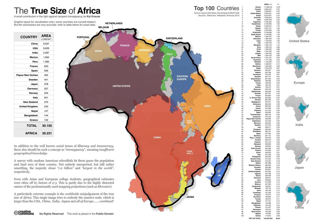
13 Population Patterns of the Eastern Hemisphere AFRICA
14 Population Patterns of the Eastern Hemisphere # 2 Review physical features and how these features are related to human characteristics. Project an outline map of Africa or Asia on the board and give students a copy of the map you use. Copies of each map are located in the Supplemental Materials (Unit 1, Lesson 5). In the case of Africa, as a class have them locate, draw, and label the major physical features of Africa such as the Nile River, the Sahara, the Atlas Mountains, the Congo River, the Kalahari Desert, the Niger River, Lake Victoria etc. The students may use their textbooks and atlases to complete this step.
15 Population Patterns of the Eastern Hemisphere Locate, draw, and label the major physical features of Africa: 1. The Nile River 2. The Sahara 3. The Atlas Mountains 4. The Congo River 5. The Kalahari Desert 6. The Niger River 7. Lake Victoria 8. Choose 3 other features (your choice) Add them to the list USE ATLAS
16 Population Patterns of the Eastern Hemisphere # 2 Human Characteristics: Ideas such as languages, religions, foods and clothing are just a few suggestions. Physical features are features of the earth that are not human made. Remember that climate is another physical feature that must be considered. Ask questions to guide the discussion such as, Where do you think few people would choose to live? Where will there be the highest population distribution? What other factors influence where people live?
17 Population Patterns of the Eastern Hemisphere # 3 Once the students have discussed what they think might be the population patterns of Africa, have them study the Population Patterns in Africa distribution map located in the Supplemental Materials (Unit 1, Lesson 5). Such maps can also be found in textbooks and atlases. The students further discuss the predictions made in Step 2. They compare historical maps of an area such as the Nile River Valley with modern maps of the same area.
18 Population Patterns of the Eastern Hemisphere (AFRICA) What factors influence where people live?

19 Population Patterns of the Eastern Hemisphere EARLY CIVILIZATIONS Compare historical maps of an area such as the Nile River Valley with modern maps of the same area.

20 Population Patterns of the Eastern Hemisphere - Mesopotamia

21 Modern Maps of Mesopotamia and

22 Modern Maps of Mesopotamia and Elevation of the Nile

23 Modern Maps of Mesopotamia and Elevation of the Nile

24 Modern Maps of Mesopotamia and Elevation of the Nile
25 Population Patterns of the Eastern Hemisphere # 3 There are two Early Civilization maps in the Supplemental Materials (Unit 1 Lesson 5). Determine what the connection is between the settlement patterns shown on each map. Note that the first major settlements were in river valleys. These river valleys had a warm climate, an abundant source of water, fertile soil and food in the form of fish. Do you think physical features are the only factors influencing settlement patterns? Answer in SS Notebook.
26 Population Patterns of the Eastern Hemisphere # 3 Human features have to be considered as well. Next look at a region of low population such as the Sahel and discuss why there are so few people who live there. The Sahel is a narrow band of semi-arid land south of the Sahara that gives way to the savannas, the broad grasslands in the tropical region. The Sahel was formerly home to large populations of grazing mammals, but over-hunting and competition from livestock has caused the endangerment and even extinction of some of the native animals. Other threats to the Sahel include periods of extreme drought and encroaching desertification. How do physical factors such as those found in the Sahel affect settlement patterns? Answer in SS notebook.

27 Population Patterns of the Eastern Hemisphere (AFRICA)
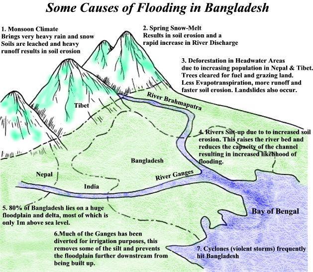
28 Population Patterns of the Eastern Hemisphere # 4 Continuing to use the outline map of Africa and reference materials, the students color or mark in the areas of highest or densest population on this continent. They might also refer to the Population Patterns in Africa map found in the Supplemental Materials (Unit 1, Lesson 5). What might the consequences might be for a country that has a large population and a high population density in terms of stress on the environment, such as intensive farming and the resulting effects of drought or desertification on the natural environment arising from the land use practices of the people? ANSWER IN YOUR SS NOTEBOOK? They can refer back to their discussion of the Sahel and then research other areas of the Eastern Hemisphere that are experiencing environmental stress. Example might include the earthquake zone in Pakistan or the flood plains of Bangladesh.

29
30
31 Population Patterns of the Eastern Hemisphere ASIA
32 Population Patterns of the Eastern Hemisphere # 5 As a final check, on the board, write the question- Why do people live where they do? 1. List as many reasons as you can in your social studies notebook. 2. Think / Pair/ Share 3. Students list their ideas under the question on the board 4. SUMMARIZE what they have learned in your SS Notebook
33 Population Patterns of the Eastern Hemisphere # 5 1 st hour Why do people live where they do?
34 Population Patterns of the Eastern Hemisphere # 5 2 nd hour Why do people live where they do?
35 Population Patterns of the Eastern Hemisphere # 5 3 rd hour Why do people live where they do?
36 Population Patterns of the Eastern Hemisphere # 5 4 th hour Why do people live where they do?
37 Population Patterns of the Eastern Hemisphere # 5 6 th hour Why do people live where they do?
38 Population Patterns of the Eastern Hemisphere Assessment The final discussion about why people live where they do will provide evidence of students understanding of the relationship between environment and patterns of settlement in the Eastern Hemisphere. Look in responses on the board and listen during students conversations for reasoning that includes the impact of physical features (including climate), references to population density, and how population patterns are related to the lives of the people in the region.
39 Population Patterns of the Eastern Hemisphere
40 Population Patterns of the Eastern Hemisphere
41 Population Patterns of the Eastern Hemisphere
42 Population Patterns of the Eastern Hemisphere
43 Population Patterns of the Eastern Hemisphere
Geography and the Early Settlement of China
 Geography and the Early Settlement of I N T E R A C T I V E S T U D E N T N O T E B O O K How did geography affect life in ancient? P R E V I E W Physical Features 1. Circle the physical features that
Sec$on 1: Geography and Early China. How does China s geography affect the culture?
 Sec$on 1: Geography and Early China How does China s geography affect the culture? Con$nents of the World Label the continents. Where is China located? Where is China located? In your groups, begin filling
Ancient China UNIT 4 GEOGRAPHY CHALLENGE. 1 Unit 4 Geography Challenge. Teachers Curriculum Institute
 UNIT 4 GEOGRAPHY CHALLENGE Ancient China N W E S 0 250 500 miles 0 250 500 kilometers Albers Conic Equal-Area Projection AW_ISN_U04_01 Ancient China Second Proof TCI18 108 1 Unit 4 Geography Challenge
UNIT4. Ancient China. Geography and the Early Settlement of China. Three Chinese Philosophies The First Emperor of China
 UNIT4 Ancient China Lesson 19 Lesson 20 Lesson 21 Lesson 22 Lesson 23 Lesson 24 Geography and the Early Settlement of China The Shang Dynasty Three Chinese Philosophies The First Emperor of China The Han
*Turn to Left Side 29*
 Homework: Africa Geo. Quiz Tuesday (pages 28-30) Do Now: Define in I.N. Glossary: Climate - average weather Vegetation Regions - areas where there are similar plants. Example: forests, deserts and grasslands.
Map Skills Lesson 1. Materials: maps, pencils, Lesson 1 Worksheet, strips of paper, grid paper
 Map Skills Lesson 1 Use cardinal directions, map grids, scales, and titles to locate places on a map. Interpret a map using information from its title, compass rose, scale, and legend. Vocabulary: map,
Exploring the Geography of West Asia
 Unit 3 - Lesson 1 Content Expectations 7 G1.1.1: Explain and use a variety of maps, globes, and web based geography technology to study the world, including global, interregional, regional, and local scales.
LET S GO ON A ROAD TRIP
 Partner School News June 2016 In this issue: Education Children Around the World www.opportunityeducation.org Road Trip Start Writing Right Now Teaching Tip of the Month Focus on Schools LET S GO ON A
GRADE 6 GEOGRAPHY TERM 1 LATITUDE AND LONGITUDE (degrees)
") 1 GRADE 6 GEOGRAPHY TERM 1 LATITUDE AND LONGITUDE (degrees) Contents Lines of Latitude... 2 Lines of Longitude... 3 The hemispheres of The Earth... 4 Finding countries and cities on a map using latitude
1 GRADE 6 GEOGRAPHY TERM 1 LATITUDE AND LONGITUDE (degrees) Contents Lines of Latitude... 2 Lines of Longitude... 3 The hemispheres of The Earth... 4 Finding countries and cities on a map using latitude
Ancient China. Teachers Curriculum Institute Geography and the Early Settlement of China 1. AW_ISN_U04_01 Ancient China Second Proof TCI18 108
 G e o g r a p h y C h a l l e n g e Ancient China N W E S 0 250 500 miles 0 250 500 kilometers Albers Conic Equal-Area Projection AW_ISN_U04_01 Ancient China Second Proof TCI18 108 Teachers Curriculum
Pre-AP World Geography Summer Assignment
 Pre-AP World Geography 2018-2019 Summer Assignment This is the summer assignment for students who intend on being accepted and enrolled in Pre-AP World Geography. Successful performance on this assignment
Unit 1: Basics of Geography Test Review
 Name Date Period Unit 1: Basics of Geography Test Review Directions: Reading the following sections and complete the questions, charts, and diagrams. Types of Maps Maps that have a particular theme are
Building the next generation of global citizens! Curriculum. International Sports Exchange
 Building the next generation of global citizens! Curriculum International Sports Exchange CURRICULUM Unit TItle: SOUTHERN AFRICA Unit Length: Weeks Guiding Questions: Can students locate the region of
Session 6: Locating the Eastern Woodlands, Plains, and Southwest Regions on a United States Map
 Session 6: Locating the Eastern Woodlands, Plains, and Southwest Regions on a United States Map Prerequisite Understanding/Knowledge/Skills Students are expected to be able to use a U.S. map to locate
Subject: Geography Unit 1: The Earth
 Subject: Geography Unit 1: The Earth Learning outcomes Activities Resources Thinking Skills Language of Learning The earth s relief and its different forms such as mountains, valleys, plains. The parts
September 14, 2013 Objective: How does geography impact history? What important features exist that have shaped societies?
 Lowenhaupt 1 September 14, 2013 Objective: How does geography impact history? What important features exist that have shaped societies? Warm-Up: In your binder, answer the following question: Imagine you
Geography Skills Progression. Eden Park Primary School Academy
 Geography Skills Progression Eden Park Primary School Academy In order to ensure broad and balanced coverage, we follow these principles: Within each phase, geography is a driver for at least 3 Learning
Physical Geography. Ariel view of the Amazon Rainforest. A Look at the Seven Continents
 Physical Geography In this unit you will learn about general physical geography. The study of the Earth s surface features provides the setting for the human-environmental interactions and for the human
World Geography to ALL Students book (teacher book).
.") Sample Pages are from the What I Need to Know to Successfully Teach World Geography to ALL Students book (teacher book). This book contains the content in the student book, the reformatted Standards for
Sample Pages are from the What I Need to Know to Successfully Teach World Geography to ALL Students book (teacher book). This book contains the content in the student book, the reformatted Standards for
EMPOWERING TEACHERS. Day 1 Read and record the details from The Earth on a large chart. LA , LA
 LA.3.1.7.5, LA.3.1.7.7 EMPOWERING TEACHERS Comprehension Instructional Routine: Compare and Contrast the Topics in Two Texts Preparation/Materials: two large texts for the teacher of The Earth and Mercury,
V Q \ = 7]Z 4IVL 126 Unit 5
![V Q \ = 7]Z 4IVL 126 Unit 5](/thumbs/77/75709676.jpg "V Q \ = 7]Z 4IVL 126 Unit 5") 126 Unit 5 Is it cold and windy? Or is it a sunny day? Is it raining cats and dogs? Or can we go out to play? I will learn to talk about seasons and weather plant life environments caring for the earth
126 Unit 5 Is it cold and windy? Or is it a sunny day? Is it raining cats and dogs? Or can we go out to play? I will learn to talk about seasons and weather plant life environments caring for the earth
Grade 3. Introduction to History and Social Science: Focus on Ancient World Cultures
 Grade 3 Introduction to History and Social Science: Focus on Ancient World Cultures The standards for third-grade students include an introduction to the heritage and contributions of the peoples of ancient
Unit 5 Geography Challenge Answers
 Unit 5 Challenge Answers Free PDF ebook Download: Unit 5 Challenge Answers Download or Read Online ebook unit 5 geography challenge answers in PDF Format From The Best User Guide Database o complete each
The Five Themes of Geography
 The Five Themes of Geography The Five Themes of Geography Main Idea: Geographers use the Five Themes of Geography to help them study the Earth. The Five Themes of Geography Geography and You: Suppose a
Geography Mile Post 1
 Mile Post 1 Use world maps, atlases and globes to identify the UK and its countries, as well as the countries, continents and oceans studied at this key stage Key Skills IPC learning Goals 1.11 Be able
World rivers investigation
 World rivers investigation Grades 3-5 This activity was designed as a companion for the music video What Does A River Want To Do?. Background What Does A River Want To Do? is a song about the countless
Many Ways to Name a Place
 Your web browser (Safari 7) is out of date. For more security, comfort and Activityapply the best experience on this site: Update your browser Ignore Many Ways to Name a Place What are the names for the
Wednesday, May 23, 2018
 Wednesday, May 23, 2018 Physical Geography of West Africa Objective: Summarize the main geographic aspects of each country in West Africa. Understand each country s development pattern and their current
Southwest and Central Asia
 Southwest and Central Asia Preview Making a Mental Map of the Region Look at the outline map of Central and Southwest Asia on the next page. Add a compass rose to the map, showing where north, south, east,
Your web browser (Safari 7) is out of date. For more security, comfort and. the best experience on this site: Update your browser Ignore
 is out of date. For more security, comfort and. the best experience on this site: Update your browser Ignore") Your web browser (Safari 7) is out of date. For more security, comfort and lesson the best experience on this site: Update your browser Ignore Political Borders Why are the borders of countries located
Your web browser (Safari 7) is out of date. For more security, comfort and lesson the best experience on this site: Update your browser Ignore Political Borders Why are the borders of countries located
Chapter 1. Social Studies History and Geography
 Chapter 1 Social Studies History and Geography Unit 01 Geography Skills 1 Reading Maps Key Words border landform rely on display focus on route locater 1 There are many different kinds of maps. A political
Exploring the World s Cultures 90 Minute Social Studies Lesson Gallery Program Grades: 3-7. Exploring the World s Cultures. Description.
 TEACHER GUIDE Exploring the World s Cultures 90 Minute Social Studies Lesson Gallery Program Grades: 3-7 Exploring the World s Cultures Description Travel the world and connect with cultures with which
A Global View. We Understand the World Better by Studying:
 Graphic Organizer A Global View We Understand the World Better by Studying: The Continents Physical Features Human Features Human/Environment Interaction Global Patterns Michigan Citizenship Collaborative
Ancient India UNIT 3 GEOGRAPHY CHALLENGE A L A. 1 Unit 3 Geography Challenge. Teachers Curriculum Institute miles
 UNIT 3 GEOGRPHY CHLLENGE ncient India HINDU KUSH HINDU KUSH H I M Desert Thar L Y N W E S 0 250 500 miles 0 250 500 kilometers Lambert zimuthal Equal-rea Projection 1 Unit 3 Geography Challenge UNIT 3
ESSENTIAL QUESTION How can we use the Mars Map and photographs of Mars to learn about the geologic history of the planet?
 GRADE LEVEL(S) 4 6 LENGTH 60 minutes MATERIALS Giant Destination Mars Map Mars Mapping Student Sheet Colored Markers (red, green, blue) VOCABULARY Crater Erode Ejecta Channel Sun Angle Sequence ESSENTIAL
About places and/or important events Landmarks Maps How the land is, hills or flat or mountain range Connected to maps World Different countries
 What do you think you know about geography? About places and/or important events Landmarks Maps How the land is, hills or flat or mountain range Connected to maps World Different countries What do you
Learning Target : Describe the purposes and uses of different types of maps.
 Learning Target : Describe the purposes and uses of different types of maps. Directions: 1. Below, place a where you think you are located. 2. In which continent are you located? 3. In which country are
4th Grade Social Studies First Nine Weeks
 4th Grade Social Studies First Nine Weeks Multiple Choice Identify the choice that best completes the statement or answers the question. 1 Name the mountains that are located in the eastern United States.
Essential Questions What are the major physical components of the world, and how are they represented on a map? 3.4
 Third Grade Social Studies Unit One Six Weeks GEOGRAPHY Originally compiled by Russellville In order for students to understand that geography influences the development of a region as well as the interactions
Geography Route Planner
 Geography Route Planner Introduction to Route Planners Route Planners outline the Key Stages 1-3 curriculum to be taught within each campus of the Bury St Edmunds Trust. Each Route Planner has been designed
Mapping Diversity in Old and New Netherland
 Your web browser (Safari 7) is out of date. For more security, comfort and Activityengage the best experience on this site: Update your browser Ignore Mapping Diversity in Old and New Netherland How did
x On record with the USOE.
 Textbook Alignment to the Utah Core 3 rd Grade Social Studies This alignment has been completed using an Independent Alignment Vendor from the USOE approved list (www.schools.utah.gov/curr/imc/indvendor.html.)
Nebraska s Place in the World
 Geographic Educators of Nebraska Advocating geographic education for all Nebraskans Nebraska s Place in the World Students will use lines of latitude and longitude to locate cities within the state and
Grade Level Expectations for the Sunshine State Standards
 for the Sunshine State Standards FLORIDA DEPARTMENT OF EDUCATION http://www.myfloridaeducation.com/ The sixth grade student: Time, Continuity, and Change [History] understands that historical events are
Chapter 21 Southwest Asia: Harsh & Arid Lands
 Name Hour Chapter 21 Southwest Asia: Harsh & Arid Lands Essential Question: How has the physical geography of Asia influenced the development of these regions (i.e. history, population distribution, &
Passwords. Social Studies Vocabulary. Texas: Grade 7
 Passwords Social Studies Vocabulary Texas: Grade 7 To the Student What is federalism? How are independence and interdependence different? What does an anthropologist do? Passwords: Social Studies Vocabulary
34 A SPRING 1 GEOGRAPHY
 Year ¾ Key Skills to be covered, taken from National Curriculum pitching at the correct year group and differentiation within plan for different groups Be specific in the key skills, and make them more
V Q \ = 5a?WZTL 156 Unit 6
 156 Unit 6 It is large and almost round. The colors are blue and brown. There are also swirls of white. It even glows at night. What a wonderful sight! What is it? I will learn to talk about physical features
Introduction to Egypt
 Instructional Sequence/Procedure (Req.): 1. Assign appropriate reading of text and an introductory take- home quiz about Egypt in anticipation of day 1 of the lesson. The quiz will not be graded, but will
Drought lesson plan ITEMS. Teachers lesson plan. Student assignments. About droughts. Real life stories. Droughts: Be prepared.
 Drought lesson plan The drought lesson plan provides teachers and students with an opportunity to investigate the Australian climate, water table and the impacts of drought through individual or classroom
Objective: Construct a paper clock by partitioning a circle into halves and quarters, and tell time to the half hour or quarter hour.
 Lesson 13 Objective: Suggested Lesson Structure Fluency Practice Concept Development Student Debrief Total Time (10 minutes) (40 minutes) (10 minutes) (60 minutes) Fluency Practice (10 minutes) Rename
How Long Does it Take to Complete the Lapbook? SAMPLE PAGE
 Keep in mind that children of the same age can have very different academic and motor skills. Some children may have trouble writing in some of the smaller spaces of this lapbook. If this describes your
Unit 2: The World in Spatial Terms (Lessons 6-7)
") Unit 2: The World in Spatial Terms (Lessons 6-7) Physical Features of Earth Create Challenges and Opportunities The physical features of Earth create both challenges and opportunities for the people living
Unit 2: The World in Spatial Terms (Lessons 6-7) Physical Features of Earth Create Challenges and Opportunities The physical features of Earth create both challenges and opportunities for the people living
Chapter 32. Australia & New Zealand
 Chapter 32 Australia & New Zealand Lesson 1: Physical Geography of Australia & New Zealand Landforms Australia lies between the Pacific and Indian Oceans in the Southern Hemisphere. Although an island,
Fourth Grade Social Studies
 AASD SOCIAL STUDIES CURRICULUM Fourth Grade Social Studies Description Fourth Grade Social Studies explores the regions of the United States with particular emphasis on the where students will spotlight
Geography Progression
 Geography Progression This document aims to track expectations for History within George Grenville Academy. What the National Curriculum says: KS1: Locational Knowledge: Name and locate the world s 7 continents
What on Earth is Geography? Using the Five Themes of Geography to Study the Continent of Asia.
 What on Earth is Geography? Using the Five Themes of Geography to Study the Continent of Asia. Name Date Essential questions: 1. How can we study the geography of our Earth? a. What are the five themes
How is Earth structured? NEW crust mantle lithosphere asthenosphere core magnetosphere. REVIEW observation
 Name Earth s Structure How is Earth structured? Date Before You Read Before you read the chapter, think about what you know about the structure of Earth Record your thoughts in the first column Pair with
name and locate the world s seven continents and five oceans
 Subject: Geography Activities National Curriculum Objectives One Progression of Skills Name the 7 continents and 5 oceans 3D Jigsaw task to locate continents and seas name and locate the world s seven
Prentice Hall. World Explorer: People, Places, Cultures Grade 7. Oklahoma Priority Academic Student Skills (PASS) for Grade 7 World Geography
 for Grade 7 World Geography") Prentice Hall World Explorer: People, Places, Cultures 2007 Grade 7 C O R R E L A T E D T O for Grade 7 1. Locate, gather, analyze, and apply information from primary and secondary sources. WORLD GEOGRAPHY
Prentice Hall World Explorer: People, Places, Cultures 2007 Grade 7 C O R R E L A T E D T O for Grade 7 1. Locate, gather, analyze, and apply information from primary and secondary sources. WORLD GEOGRAPHY
Iceland. 1. Warm up. A. Talk about the picture and read the essay. B. Discuss the questions about the essay.
 1. Warm up A. Talk about the picture and read the essay. Iceland My country, Iceland, is one of the most beautiful countries on Earth. It is an island country. It is located in Europe, in the North Atlantic
6 th Grade: Regions and People of the World ESC Suggested Pacing Guide
 Norton City Schools Standards-Based Social Studies Course of Study 2005 6 th Grade: Regions and People of the World ESC Suggested Pacing Guide 2005-06 The sixth grade year focuses on the study of world
Middle School. Assessment Focus: Strand 2 Developing a Geographic Perspective. Geography Content Standard Location, Movement, and Connection
 MS05 Michigan Geographic Alliance(1996) Geography Sample Item Middle School Assessment Focus: Strand 2 Developing a Geographic Perspective Geography Content Standard Location, Movement, and Connection
Range of Opportunities
 Geograhy Curriculum Cropwell Bishop Primary School Range of Opportunities Year 1 Year 2 Year 3 Year 4 Year 5 Year 6 All Key Stage 1 Key Stage 2 Investigate the countries and capitals of the United Kingdom.
Earth s Layers. Earth s Surface
 CHAPTER 1 LESSON 3 Earth s Layers Earth s Surface Key Concepts What are Earth s major landforms and how do they compare? What are the major landform regions of the United States? What do you think? Read
Lesson Graphic Organizer
 Lesson Graphic Organizer Theme Location Where is it? Questions What is its absolute location? What is its relative location? Place What is it like there? What are its natural characteristics? What are
Science Standard 1: Students analyze monthly precipitation and temperature records, displayed in bar charts, collected in metric units (mm).
.") Title: Precipitation Patterns across the Globe NSF GK-12 Fellow: Terry Legg Type of Lesson: STEM Grade Level(s): 4 th - 7 th grade This activity can be tailored to older, more advanced students by having
Title: Precipitation Patterns across the Globe NSF GK-12 Fellow: Terry Legg Type of Lesson: STEM Grade Level(s): 4 th - 7 th grade This activity can be tailored to older, more advanced students by having
1. Match the words in the first column to the meaning in the second column. [5]
![1. Match the words in the first column to the meaning in the second column. [5]](/thumbs/96/126839765.jpg "1. Match the words in the first column to the meaning in the second column. [5]") Exercise 1: [40 POINTS] 1. Match the words in the first column to the meaning in the second column. [5] Equator Around earth between the Equator and the Poles. Greenwich meridian Half of earth. Longitude
Exercise 1: [40 POINTS] 1. Match the words in the first column to the meaning in the second column. [5] Equator Around earth between the Equator and the Poles. Greenwich meridian Half of earth. Longitude
a. Hunting and gathering SE/TE: 17, 19, 21, 22, 23, 25, 30 b. Tool making SE/TE: 17, 18, 19, 22, 23 c. Use of fire SE/TE: 17, 23, 30
 Ohio Academic Content Standards, Social Studies, Benchmarks and Indicators (Grade 6) Grade Six History Students use materials drawn from the diversity of human experience to analyze and interpret significant
Using Geography to Plan Civil War Campsites
 Jake Gordon Civil War Campsite Mapping Lesson Plan pg1 Using Geography to Plan Civil War Campsites Overview: This lesson is designed for an 8 th grade social studies class during the Civil War unit. Students
The Ancient World. Chapter 1 The Beginnings of Human Society. What historical accomplishments is each civilization known for?
 Chapter 1 The Beginnings of Human Society Chapter 1-Guiding Questions: What historical accomplishments is each civilization known for? How did physical geography affect the growth of ancient civilizations
NEWHAM BRIDGE PRIMARY SCHOOL FOUNDATION SUBJECTS CURRICULUM AND ASSESSMENT DOCUMENT GEOGRAPHY
 NEWHAM BRIDGE PRIMARY SCHOOL FOUNDATION SUBJECTS CURRICULUM AND ASSESSMENT DOCUMENT GEOGRAPHY Y1 Geography Curriculum Y1 Geography A.R.E Locational language: hills, beach, forest, town, country, address,
Warm up: (8 min) Use the Map, On the Prom (Color) Paper (Blk/White) and answer the questions on your paper
 Use the Map, On the Prom (Color) Paper (Blk/White) and answer the questions on your paper") Warm up: (8 min) Use the Map, On the Prom (Color) Paper (Blk/White) and answer the questions on your paper TX History: Mapping and Geography of Texas: We will discuss some slides and write notes on others
Warm up: (8 min) Use the Map, On the Prom (Color) Paper (Blk/White) and answer the questions on your paper TX History: Mapping and Geography of Texas: We will discuss some slides and write notes on others
World Geography. Teacher s Guide
 World Geography Teacher s Guide WALCH PUBLISHING Table of Contents To the Teacher.......................................................... vi Classroom Management.................................................
5th social studies geography (5thsocstud_geography)
") Name: Date: 1. Many of the Native Americans who lived on the Great Plains were nomadic people. Why did they move from place to place? A. They were finding new areas to mine. B. They were looking for fertile
Name: Date: 1. Many of the Native Americans who lived on the Great Plains were nomadic people. Why did they move from place to place? A. They were finding new areas to mine. B. They were looking for fertile
KNES Primary School Year 1 Geography Course Outline: Term 1, 2 and 3
 KNES Primary School Year 1 Geography Course Outline: 2017-2018 Term 1, 2 and 3 Overview. Term 1, 2 and 3 Brief overview of topics to be covered during the year Resources to be used-textbooks, other sources
Traveling. Through Time
 Traveling Through Time Ancient River Valley Civilizations Name: Class Period: 1 Essential Vocabulary #1 Hominids Artifacts Culture Nomads Agriculture Domestication Civilization Irrigation Cultural Diffusion
Map directions are broken down into 2 main types; Cardinal Directions and Intermediate Directions SW S
 ELEMENTS OF MAPS COMPASS ROSE AND DIRECTIONS When reading a map it s always important to know your directions. The Compass Rose is the tool to help you do that. Map directions are broken down into 2 main
CURRICULUM UNIT MAP 1 st QUARTER. COURSE TITLE: Science GRADE: 4
 1 st Unit: Scientific Method Know the seven steps of the scientific method The students will complete a study guide of and use them to solve scientific problems the 7 steps Identify the problem, form a
WG.21.C Create and interpret different types of maps to answer geographic questions, infer relationships, and analyze change.
 Unit: Essentials Cartography (Maps) Social Studies Skills Standards: WG.21.A Analyze and evaluate the validity, and utility of multiple sources of geographic information such as primary and secondary sources,
This image cannot currently be displayed. Course Catalog. History and Geography Glynlyon, Inc.
 This image cannot currently be displayed. Course Catalog History and Geography 2016 Glynlyon, Inc. History and Geography Table of Contents COURSE OVERVIEW... 1 UNIT 1: OUR EARTH... 1 UNIT 2: SEAPORT CITIES...
Part 1: What are the five themes of geography? Explain the meaning of each and give an example.
 Name Key Date Hour Part 1: What are the five themes of geography? Explain the meaning of each and give an example. 1. Movement What does this mean? Here is an example: 2. Region What does this mean? the
The Impact of Geography in South and East Asia
 The Impact of Geography in South and East Asia Gobi desert, Mongolia Essential Question: How does geography impact the distribution of population throughout South and East Asia? I CAN Explain how geography
Barlows Primary School Geography Curriculum Content Key Stage 1 and
 Geography Curriculum Content Key Stage 1 and 2 2017-2018 Curriculum Content Year 1 The content for Year 1 is detailed below: WHAT ARE SEASONS? WHAT SIT LIKE WHERE WE LIVE? WHERE DO DIFFERENT ANIMALS LIVE?
Elementary Social Studies Content Area Assessment Task. Winter 2010 EDUC 203
 1 Elementary Social Studies Content Area Assessment Task Winter 2010 EDUC 203 Students: Fourth grade class in Watsonville, CA. Approximately 90% Latino, primarily of Mexicandescent. About 80% participate
Reading for Information Grade 2 Correlations to Idaho Content Standards
 Science Life Science Physical Science Grade 2 Leveled Plants Live and Grow Plants: Alive and Growing Plants: Living and Growing It Takes Force Making Things Move Facts about Force Grade 2 Correlations
HUDSONVILLE MIDDLE SCHOOL COURSE FRAMEWORK
 HUDSONVILLE MIDDLE SCHOOL COURSE FRAMEWORK COURSE/SUBJECT 6 th Grade Social Studies UNIT PACING Unit 1 ~ Foundations of Social Studies September - October (6 weeks) explain that historians organize time
locate the world s countries, using maps to focus on Europe (including the location of
 Year 3 and 4 Geography study- Autumn 2 2017 National curriculum: Locational knowledge locate the world s countries, using maps to focus on Europe (including the location of Russia) and North and South
Geography Long Term Plan 2018
 Geography Long Term Plan 2018 Geography Co-ordinator: Megan Frost A high-quality geography education should inspire in pupils a curiosity and fascination about the world and its people that will remain
Classroom Activity to Make Fraction Strips
 Classroom Activity to Make Fraction Strips This resource provides instructions on teaching your students how to make fraction strips out of paper. Fraction strips made from copy paper are an excellent
Your web browser (Safari 7) is out of date. For more security, comfort and the best experience on this site: Update your browser Ignore
 is out of date. For more security, comfort and the best experience on this site: Update your browser Ignore") Your web browser (Safari 7) is out of date. For more security, comfort and the best experience on this site: Update your browser Ignore Activitydevelop TRADE IN THE 1600S What did Native Americans and
Your web browser (Safari 7) is out of date. For more security, comfort and the best experience on this site: Update your browser Ignore Activitydevelop TRADE IN THE 1600S What did Native Americans and
The Impact of Geography in South and East Asia
 The Impact of Geography in South and East Asia Gobi desert, Mongolia Essential Question: How does the geography of SE Asia impact trade and the distribution of population throughout the region? (AKS #52a)
a division of Teacher Created Materials
 Sample Pages from a division of Teacher Created Materials Thanks for checking us out. Please call us at 877-777-3450 with questions or feedback, or to order this product. You can also order this product
Great Lakes in My World
 Great Lakes in My World www.greatlakes.org Unit: Lakes Michigan: Social Studies 1. Lakes Activities Lake Connection I Am A Camera Maps of Home Watershed Orientation Satisfy Your Curiosity Eco-Language
Module 2 Educator s Guide Overview
 Module 2 Educator s Guide Overview Water, water almost everywhere? Module Overview The presence of water in solid, liquid, and gaseous forms is one of the primary factors that distinguishes Earth from
Ecoregions of Oregon: Many Pieces, One Puzzle
 Ecoregions of Oregon: Many Pieces, One Puzzle Overview: The purpose of this lesson is to improve and refine knowledge of Oregon s Ecoregions. Designed as an introductory lesson, students will be using
Centerville Jr. High School Curriculum Mapping (7 th Grade Geography) (Mike Day)
 (Mike Day)") Centerville Jr. High School Curriculum Mapping (7 th Grade Geography) (Mike Day) Standard 1 History Students examine the major movements, events and figures that contributed to the development of Africa,
Centerville Jr. High School Curriculum Mapping (7 th Grade Geography) (Mike Day) Standard 1 History Students examine the major movements, events and figures that contributed to the development of Africa,
Geography. Programmes of study for Key Stages 1-3
 Geography Programmes of study for Key Stages 1-3 February 2013 Contents Purpose of study 3 Aims 3 Attainment targets 3 Subject content 4 Key Stage 1 4 Key Stage 2 5 Key Stage 3 6 2 Purpose of study A high-quality
The Impact of Geography in South and East Asia
 The Impact of Geography in South and East Asia Gobi desert, Mongolia Essential Question: How does the geography of SE Asia impact trade and the distribution of population throughout the region? (AKS #52a)
HOLY CROSS CATHOLIC PRIMARY SCHOOL
 HOLY CROSS CATHOLIC PRIMARY SCHOOL Geography Policy Date Implemented Jan 17 Review Date Jan 22 Mission Statement Holy Cross Primary School is a Catholic School. We seek to provide a broad, balanced Christian