The I-81 Challenge: Study update and overview of travel demand model CNY Engineering Expo November 12, 2012
|
|
|
- Magnus Gilmore
- 5 years ago
- Views:
Transcription

1 The I-81 Challenge: Study update and overview of travel demand model CNY Engineering Expo November 12, 2012 Presented by: Meghan Vitale, SMTC Jason Deshaies, SMTC
2 Presentation overview Part 1: Overview of The I-81 Challenge What is The I-81 Challenge Process Current uses and concerns Case Studies Visions, strategies, and goals Part 2: Overview of the SMTC Travel Demand Model Goals of the I-81 modeling project Model overview Review and enhancement Outputs & examples Extensions to regional model Next steps Questions and Answers
3 Approach The I-81 Challenge is the official decision making process to determine the future of I-81 through the Syracuse region. Partnership between the NYSDOT and SMTC, at NYSDOT s request Began in fall of 2009 Three separate but integrated efforts: The I-81 Challenge I-81 Corridor Study NYSDOT Existing physical conditions analysis Inventory of existing land use, economic, social, environmental conditions Transit system review Identify viable improvement options Public Participation Project SMTC Inform public about process Engage in public dialogue Understand community s goals Facilitate public input into development and refinement of options Travel Demand Modeling SMTC Refine and upgrade SMTC s travel demand model Model alternatives
4 Committees SAC Study Advisory Committee SMTC member agencies Meets regularly Reviews and comments on materials Advises on approach MLC Municipal Liaison Committee Municipal supervisors/mayors Meets prior to major outreach Provides input on municipal concerns Disseminates project information CLC Community Liaison Committee Representatives of community organizations Meets prior to major outreach Provides input on community concerns Disseminates project information
5 Study Advisory Committee New York State Transportation Environmental Conservation Empire State Development Onondaga County Legislature Physical Services Transportation CenterState Corporation for Economic Opportunity NYS Thruway Authority Onondaga Nation City of Syracuse Mayor s office Common Council Neighborhood and Business Development Engineering Public Works Central NY Regional Planning & Development Board Syracuse-Onondaga County Planning Agency Federal Highway Administration Central NY Regional Transportation Authority (Centro)
6 Project Area Entire I-81 corridor in the SMTC area Emphasis on the elevated portions in city

7 Process We are here


8 Major Accomplishments to Date Technical analysis Travel demand model update and refinement Physical Conditions Analysis Public outreach Products/publications Case study report Educational videos Fact Sheet FAQs Physical Conditions Highlights Public Workshops Summary Report White Papers 1&2 Events Focus groups Community group meetings May 2011 public workshops May 2012 public meeting On-going communication Website, blog, Facebook Newsletters blasts Questionnaires


9 Physical Conditions Analysis Transportation System Critical design elements Highway and bridge conditions Traffic volumes Regional Interstate Through Traffic Level of Service and Mobility Accident Analysis Pedestrians and Bicyclists Transit Land Use and Economic Conditions Social and environmental conditions

10 Safety, Congestion, and Design Significant portions of I-81 have nonstandard or non-conforming design features. Generally coincide with areas of: Increased congestion High accident rates 70% of bridges in primary study area classified as functionally obsolete or structurally deficient By 2050, more than 80% of bridges will have met or exceeded their expected service life I-81 through the I-690 interchange has sections where accident rates reach five times the statewide average

11 Traffic volumes Little if any growth since % heavy vehicles during peak hours AADT in primary study area: 43,000 to 99,000 About 45,000 vehicles per day get on/off I-81 at Adams/Harrison
 Only 6% of total traffic is currently using I-81 to travel through the region Diverting regional interstate through traffic to")
12 Regional Interstate Through Traffic Used Automated License Plate Readers to collect data in April % overall capture rate 44,000 vpd on I-81 south of Exit 16A 5,400 vpd currently travel through the region without stopping (12% of the total volume south of Exit 16A) Only 6% of total traffic is currently using I-81 to travel through the region Diverting regional interstate through traffic to I-481 or other alternative route will have little impact on operations on I-81 in the primary study area.
13 Public outreach by the numbers Meeting attendance Small group community meetings: 20+ meetings, 200+ attendees Focus groups: 23 meetings, 176 participants May 2011 workshops: 700 people, 200 online participants May 2012 public meeting: 480 people, 250 online participants Questionnaires 2009/2010: 100 responses 2011: 990 responses 2012 Transit Survey: 229 responses (174 non/former riders, 55 riders) Communications 1,200+ contacts for e-blasts 3,000 contacts for mailed newsletters and meeting notices 250 Facebook likes Approx. 400 unique website visitors per month

14 Public involvement key findings I-81 is part of what defines the region Uses of the highway include: Commuting to work and school Leisure trips and errands Long-distance travel In addition to driving on I-81, people also experience I-81 by: Driving or parking under I-81 Walking and biking near I-81 Living near I-81 I-81 s negative impacts include: Perceived barrier and visually unappealing Source of pollution, promotes car-centric culture I-81 s positive impacts on our region include: Connections to key destinations Mobility and quick access Supports regional economy

15 Public involvement key findings From Spring 2011 Questionnaire: Current travel time in the Syracuse region Tolerable future travel time Less than 20 minutes 22% 20 to 29 minutes 37% 30 to 39 minutes 25% 40 to 59 minutes 10% 60 minutes or more 6% Tolerable change in travel time More Time Less Time
16 2011 Questionnaire key findings Respondents asked to prioritize a list of 20 potential benefits of an improved I-81 corridor Economic development benefits are important A revitalized downtown Syracuse economy Economic development with more businesses locating in the Syracuse region An improved roadway network that is clearer & easier for traveling in Syracuse region Safer roadway network with fewer traffic accidents Improved & safer highway interchanges/exits Improved roadway access & travel times for emergency services Less traffic congestion & more reliable travel Improved development policies & land use planning for the region Improved sense of community pride & optimism Improved connectivity & integration of the downtown & Univ. Hill Building/upgrading city sidewalks & bike paths Beautifying downtown & Univ. Hill More transportation options for young/ elderly/disabled/low-income populations Less air pollution or emissions coming from traffic Most Important Expanded transit service Shorter time to travel to/from work Increased efficiency for delivering commercial goods/services Shorter time to travel to/from the downtown & Univ. Hill Increased frequency & number of hours per day buses run to downtown & Univ. Hill Less noise from traffic in the downtown and on Univ. Hill Least Important


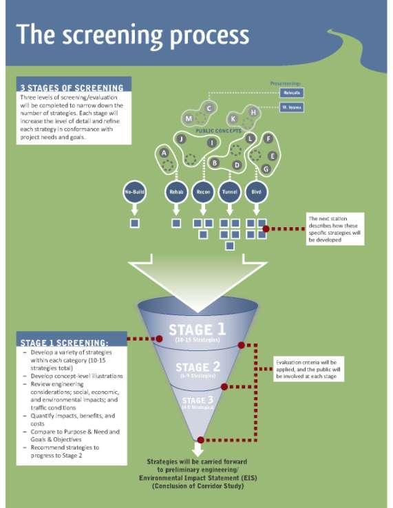
17 Case studies Common project outcomes Reconstruct Tunnel Depress Relocate Remove Lessons learned Traffic is adaptable focus on moving people Highways have positive and negative effects, design can mitigate negatives Involve stakeholders, respond to community goals

18

19
20
21
22

23

24

25

26
27

28

29
30
31 Feedback from May 2012 public meeting Common concerns from strategy comments: Safety Accessibility to regional destinations Support for alternative modes Physical/visual impact of viaduct Economic development Fiscal impact Neighborhood impacts Suggestions to consider as strategies are developed: Improve access to downtown and University Hill Improve safety Enhance physical environment around viaduct lighting, ped amenities I-81/I-690 interchange improve safety and connectivity Provide access to I-81 within the city south of downtown
32 Feedback from May 2012 public meeting Transit needs/enhancements, based on meeting comments and survey results: Reduce transit travel time Increase frequency and hours of operation Provide more real-time information Provide direct connections between major regional destinations Improve safety and public perception of transit Provide more suburban commuter options Improve on-time performance Maintain affordable fare Rider survey did not reach high number of daily or weekly riders or people without access to a car.
33 Travel Demand Modeling Part 2: Overview of the SMTC Travel Demand Model Goals of the I-81 modeling project Model overview Review and enhancement Outputs & examples Extensions to regional model Next steps
34 Project Goal Goal of Modeling Project: To ensure that the transportation modeling and analysis is defensible and usable for many years as this study proceeds through the project development process. It is critical that the analysis and ensuing decisions from this study fully integrate public comment and are defensible beyond this particular study. Minimum Requirements VMT Estimation Travel Speed Estimation Suggested Best Practices Validation against Observed Counts Latest Planning Assumptions Land Use Development Scenarios Assignment Methodology Travel Impedances Model Sensitivity
35 Goals and Objectives Review and Enhance the Model Objective: Produce an updated and enhanced travel demand model that is consistent with good practice and will function appropriately for the I-81 study. Understand Travel Demand on I-81 Objective: Understand the magnitude of the demand through the corridor and quantify the regional importance of I-81. Model Strategies for I-81 Objective: Measure the important transportation-related impacts of each strategy in a defensible way and with the appropriate level of detail at each stage of the study.

36 Model Overview Regional Travel Demand Model Model area = SMTC planning area 972 internal TAZs 51 external TAZs Road network includes all major and some local roads Transit network includes all Centro fixed routes Base year 2007 Horizon year is 2040

37 Model Overview 4-Step Model The SMTC model also includes a time of day split step, where trips are split into time periods, and a feedback loop so that trip distribution and mode choices reflect congested travel times


38 Model Review and Enhancement Model Refinement Housing and employment Highway network Special generators Characteristics of Demand e.g. Land Development Travel Demand Forecasting Characteristics of the Transportation System e.g. Road Network Model Validation Are model outputs reasonable? Amount of Travel, Mode Usage Transportation System Performance e.g. Volume, Operations
39 Model Review and Enhancement Refinement Review base year and forecast year land use assumptions Are updates required for current household and employment data? Are household and employment projections reasonable? Review network coding Are there connectivity problems or errors in coding (e.g. wrong number of lanes) Are intersection types and capacities coded correctly? Review special generators Do special generator trip distributions match with observed data or reasonable assumptions about likely trip distributions? Validation Review vehicle speeds & volumes Are vehicle speeds on key facilities reasonable? Do segment volumes match observed traffic count data?
40 Model Review and Enhancement Land use data refinement process Review existing data (2003 & 2027) Meet with local planners and development representatives Compile and review available socioeconomic datasets Refine 2003 data and disaggregate to refined TAZs Extrapolate data to 2007 Project 2007 data to 2040


41 Model Review and Enhancement Meetings with Local Representatives Central New York Regional Planning & Development Board Syracuse-Onondaga County Planning Agency Onondaga County Office of Economic Development CenterState Corporation for Economic Opportunity Syracuse Department of Neighborhood & Business Development Syracuse Industrial Development Agency Syracuse Bureau of Planning & Sustainability Empire State Development Corporation New York State Department of Labor Various Municipal Representatives
42 Model Review and Enhancement These are the questions we asked Identify areas of recent household & economic growth/decline Identify areas of projected household & employment growth/decline over next 30 years Several themes that emerged in regards to households Continued growth of households in northern half of county Rate of household decline in the City of Syracuse has slowed Several themes that emerged in regards to employment Reduction in job growth from previous projections Overall growth of about 1,000 jobs per year in Onondaga County Continued growth of healthcare jobs in Syracuse
43 Model Review and Enhancement Compile & Review Available Datasets Household Data U.S. Census Bureau Cornell University Program on Applied Demographics Woods and Poole Economics Syracuse-Onondaga County Planning Agency Employment Data New York State Department of Transportation U.S. Census Bureau Woods and Poole Economics New York State Department of Labor Greater Syracuse Economic Growth Council Resource Center Syracuse-Onondaga County Planning Agency Syracuse.com
 Source: www.syracuse.com (Feb.")
44 Model Review and Enhancement Compile & Review Available Datasets Identify recent job growth/decline ( ) Source: (Feb. 2009)
 RED = old TAZs GREEN = new")
45 Model Review and Enhancement Refine 2003 Data & Disaggregate TAZ geography refined (increase number of TAZs from 697 to 1023) RED = old TAZs GREEN = new TAZs
46 Model Review and Enhancement Extrapolate to 2007 & Project to 2040 Combine local knowledge and existing data Control totals were set at the town and county level Final household and employment numbers were shared and reviewed Change in Households Change in Employment Onondaga County 6.7% City of Syracuse -1.1% County (minus City) 10.9% Onondaga County 12.3% City of Syracuse 13.4% County (minus City) 11.6%

47 Model Review and Enhancement Change in household density Change in employment density

48 Model Review and Enhancement Network Coding Road segments coded correctly? Review # of lanes, functional classification, posted speed limits, etc. for all model links Aerial photography and field verification Intersections coded correctly? Review intersection types for entire model area Aerial photography and field verification

49 Hancock International Airport Special Generators The New York State Fairgrounds OnCenter Onondaga Community College Carrier Dome Community General Hospital/ Van Duyn Home and Hospital Alliance Bank Stadium Carousel Center St. Joseph s Hospital Le Moyne College Upstate Medical University Hospital Syracuse University Main Campus Syracuse University South Campus SMTC collected data from institutions Employee home ZIP codes Number of patients, enrolled students, air travelers, customers by ZIP code Available transportation related survey data Model updated using these data to replicate observed travel patterns Loretto
50 Model Review and Enhancement Validate with Traffic Counts Approximately 2400 traffic counts were used for model validation The new model exceeds FHWA guidelines and matches traffic counts in the study corridor FHWA Guideline Model Correlation Coefficient % Error Region-Wide + / - 5% -1.5% Sum of Differences Freeways + / - 7% -2.4% Principal Arterials + / - 10% 4.9% Minor Arterials + / - 15% 0.6% Collectors + / - 25% -0.9% 60,000 50,000 40,000 30,000 20,000 10,000 0 I-690 West Bound Stantec Count Model Volume W. Genesee I-90 West St. I-81 I-481


51 Model Review and Enhancement Conducted Speed Study Collect average speeds for major corridors Focus on facilities with no/limited count data Used stop watches and GPS units At least 3-4 runs in both directions for each time period (AM Peak, PM Peak and Off Peak)


52 Model Review and Enhancement Validate with Speed Data The new model improves estimated travel speeds.
 - Vehicle miles traveled (VMT) -")

53 Model Outputs - Number of vehicles - Number of trips by trip type (HBW, HBS, HBO, NHB) - Vehicle miles traveled (VMT) - Vehicle hours traveled (VHT) - Transit trips - Intersection congestion & delay - Average speed - Volume to capacity ratio


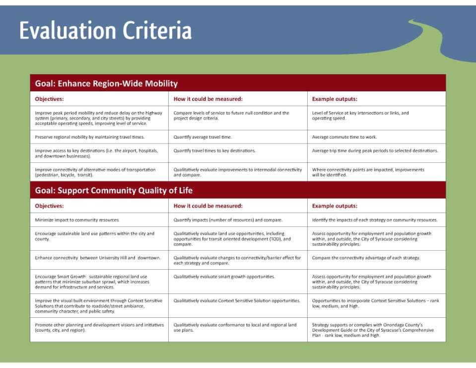
54 Model Outputs How can we use the model for The I-81 Challenge? Example: Change in Intersection Delay Compare each strategy to the no-build strategy using various model outputs Look at change in volumes, V/C ratios, VMT, VHT, etc. Help us measure some of our project objectives Objective Improve peak period mobility and reduce delay


55 Model Outputs Example: Change in Daily Vehicle Hours Traveled Objective Preserve regional mobility by maintaining travel times

56 Model Outputs Example: Change in Drive Time (minutes) Objective Improve access to key destinations This is the change in drive time to downtown in the peak Specific to one location (can do this for any location)
57 Extensions to Regional Model Extensions to this analysis Refined analysis & microsimulation of traffic Estimate emissions and noise Impact to targeted populations (e.g. low income) Impact to specific locations (e.g. hospitals) Better understand non-auto travel Make value judgments on transportation impacts
 Most dramatic impacts likely in central Syracuse More detailed analyses will be necessary where impacts are most severe (traffic impact analysis) Corridor")
 Queue lengths Sub-area level")
58 Extensions to Regional Model Regional Modeling and Corridor Study Transportation impacts will extend well beyond I-81 corridor Impacts will be measurable for the entire region (regional modeling) Most dramatic impacts likely in central Syracuse More detailed analyses will be necessary where impacts are most severe (traffic impact analysis) Corridor study will model (using microsimulation) a sub area, say downtown, taking output from regional model Regional Model Regional statistics such as Vehicle Mile Traveled, Vehicle Hours Traveled Daily traffic volumes Average speeds Regional level routing Corridor Study Microsimulation Intersection levels of service (delays) Queue lengths Sub-area level routing

59 Next Steps Define strategies and begin stage 1 screening No-build Rehabilitate Reconstruct Tunnel/Depressed Boulevard
 Develop strategies for Stage 1 screening Additional public meetings to present")
, with")
60 Within the current Corridor Study (approx. 12 months) Develop strategies for Stage 1 screening Additional public meetings to present and refine options Short list of 4-5 viable options Beyond the Corridor Study Refine preferred options through finegrained analysis Conduct environmental review (EIS), with continued public involvement Reach ultimate decision
61 Questions What are the key components of the I-81 Challenge? Technical analysis (including travel demand modeling) and public participation What percentage of regional interstate traffic currently travels through the region without stopping? 12% How do accident rates on I-81 through the I-690 interchange compare to the statewide average? Up to 5 times the statewide average From the May 2012 public meeting, what strategies were recommended to progress to Stage 1 screening? No-build, reconstruction, rehabilitation, tunnel/depressed, and boulevard
62 Questions What were some of the common themes from the comments at the May 2012 public meeting? Safety, accessibility to regional destinations, support for alternative modes, physical/visual impact of viaduct, economic development, fiscal impact, neighborhood impacts What are the steps of a 4-step model? Trip generation, trip distribution, mode choice, assignment What data did the SMTC collect to help validate model results? Average speed data and traffic counts
63 Get Involved thei81challengeblog.org
Appendixx C Travel Demand Model Development and Forecasting Lubbock Outer Route Study June 2014
 Appendix C Travel Demand Model Development and Forecasting Lubbock Outer Route Study June 2014 CONTENTS List of Figures-... 3 List of Tables... 4 Introduction... 1 Application of the Lubbock Travel Demand
3.0 ANALYSIS OF FUTURE TRANSPORTATION NEEDS
 3.0 ANALYSIS OF FUTURE TRANSPORTATION NEEDS In order to better determine future roadway expansion and connectivity needs, future population growth and land development patterns were analyzed as part of
FHWA Peer Exchange Meeting on Transportation Systems Management during Inclement Weather
 Travel Demand Modeling & Simulation at GBNRTC Matt Grabau Kimberly Smith Mike Davis Why Model? Travel modeling is a tool for transportation planners and policy makers, to observe impacts of a transportation
Study Overview. the nassau hub study. The Nassau Hub
 Livable Communities through Sustainable Transportation the nassau hub study AlternativeS analysis / environmental impact statement The Nassau Hub Study Overview Nassau County has initiated the preparation
SBCAG Travel Model Upgrade Project 3rd Model TAC Meeting. Jim Lam, Stewart Berry, Srini Sundaram, Caliper Corporation December.
 SBCAG Travel Model Upgrade Project 3rd Model TAC Meeting Jim Lam, Stewart Berry, Srini Sundaram, Caliper Corporation December. 7, 2011 1 Outline Model TAZs Highway and Transit Networks Land Use Database
2015 Grand Forks East Grand Forks TDM
 GRAND FORKS EAST GRAND FORKS 2015 TRAVEL DEMAND MODEL UPDATE DRAFT REPORT To the Grand Forks East Grand Forks MPO October 2017 Diomo Motuba, PhD & Muhammad Asif Khan (PhD Candidate) Advanced Traffic Analysis
StanCOG Transportation Model Program. General Summary
 StanCOG Transportation Model Program Adopted By the StanCOG Policy Board March 17, 2010 What are Transportation Models? General Summary Transportation Models are technical planning and decision support
HORIZON 2030: Land Use & Transportation November 2005
 PROJECTS Land Use An important component of the Horizon transportation planning process involved reviewing the area s comprehensive land use plans to ensure consistency between them and the longrange transportation
April 18, Accessibility and Smart Scale: Using Access Scores to Prioritize Projects
 Accessibility and Smart Scale: Using Access Scores to Prioritize Projects April 18, 2017 Accessibility and Smart Scale: Using Access Scores to Prioritize Projects State Smart Transportation Initiative
Mapping Accessibility Over Time
 Journal of Maps, 2006, 76-87 Mapping Accessibility Over Time AHMED EL-GENEIDY and DAVID LEVINSON University of Minnesota, 500 Pillsbury Drive S.E., Minneapolis, MN 55455, USA; geneidy@umn.edu (Received
California Urban Infill Trip Generation Study. Jim Daisa, P.E.
 California Urban Infill Trip Generation Study Jim Daisa, P.E. What We Did in the Study Develop trip generation rates for land uses in urban areas of California Establish a California urban land use trip
2014 Certification Review Regional Data & Modeling
 2014 Certification Review Regional Data & Modeling July 22, 2014 Regional Data Census Program Coordination PAG works with and for member agencies to ensure full participation in all Census Bureau programs
III. FORECASTED GROWTH
 III. FORECASTED GROWTH In order to properly identify potential improvement projects that will be required for the transportation system in Milliken, it is important to first understand the nature and volume
Alternatives Analysis
 Alternatives Analysis Prepared for: Metropolitan Atlanta Rapid Transit Authority Prepared by: AECOM/Jacobs-JJG Joint Venture Atlanta, GA November 2012 Page Left Intentionally Blank ii TABLE OF CONTENTS
Frequently Asked Questions
 What is the Regional Transit Engagement Series? As one of the fastest growing regions in the country, there is recognition that long-term transit planning efforts should be accelerated if we are to remain
Figure 8.2a Variation of suburban character, transit access and pedestrian accessibility by TAZ label in the study area
 Figure 8.2a Variation of suburban character, transit access and pedestrian accessibility by TAZ label in the study area Figure 8.2b Variation of suburban character, commercial residential balance and mix
APPENDIX IV MODELLING
 APPENDIX IV MODELLING Kingston Transportation Master Plan Final Report, July 2004 Appendix IV: Modelling i TABLE OF CONTENTS Page 1.0 INTRODUCTION... 1 2.0 OBJECTIVE... 1 3.0 URBAN TRANSPORTATION MODELLING
CLAREMONT MASTER PLAN 2017: LAND USE COMMUNITY INPUT
 Planning and Development Department 14 North Street Claremont, New Hampshire 03743 Ph: (603) 542-7008 Fax: (603) 542-7033 Email: cityplanner@claremontnh.com www.claremontnh.com CLAREMONT MASTER PLAN 2017:
Economic and Social Urban Indicators: A Spatial Decision Support System for Chicago Area Transportation Planning
 Economic and Social Urban Indicators: A Spatial Decision Support System for Chicago Area Transportation Planning Piyushimita Thakuriah (Vonu), P.S. Sriraj, Paul Metaxatos, Inshu Minocha & Tanushri Swarup
City of Saginaw Right of Way Division Snow and Ice Removal Policy January 18, 2016
 Snow and Ice Removal Policy January 18, 2016 It is the policy of the to provide snowplowing and ice removal services in order to: Provide safe traveling conditions for motorists and pedestrians Assist
Regional Performance Measures
 G Performance Measures Regional Performance Measures Introduction This appendix highlights the performance of the MTP/SCS for 2035. The performance of the Revenue Constrained network also is compared to
East Bay BRT. Planning for Bus Rapid Transit
 East Bay BRT Planning for Bus Rapid Transit Regional Vision Draper Prison The Bottleneck is a State-Level issue, Salt Lake County 2050 Population: 1.5M Draper Prison hopefully with some State-Level funding!
Proposed Scope of Work Village of Farmingdale Downtown Farmingdale BOA Step 2 BOA Nomination Study / Draft Generic Environmental Impact Statement
 Proposed Scope of Work Village of Farmingdale Downtown Farmingdale BOA Step 2 BOA Nomination Study / Draft Generic Environmental Impact Statement The scope of work that follows incorporates and covers
Regional Performance Measures
 G Performance Measures Regional Performance Measures Introduction This appendix highlights the performance of the MTP/SCS for 2035. The performance of the Revenue Constrained network also is compared to
Neighborhood Locations and Amenities
 University of Maryland School of Architecture, Planning and Preservation Fall, 2014 Neighborhood Locations and Amenities Authors: Cole Greene Jacob Johnson Maha Tariq Under the Supervision of: Dr. Chao
Committee Meeting November 6, 2018
 Committee Meeting November 6, 2018 Agenda Where we are in the process Land Use Plan Transportation Element Housing & Neighborhoods Elements Next Steps Schedule November 6: Plan Elements December: Plan
Changes in the Spatial Distribution of Mobile Source Emissions due to the Interactions between Land-use and Regional Transportation Systems
 Changes in the Spatial Distribution of Mobile Source Emissions due to the Interactions between Land-use and Regional Transportation Systems A Framework for Analysis Urban Transportation Center University
Appendix C Final Methods and Assumptions for Forecasting Traffic Volumes
 Fairview Ave. and Main St. Improvements and Local Streets Plan Appendices Ada County Highway District Appendix C Final Methods and Assumptions for Forecasting Traffic Volumes January 3, 207 Appendices
Environmental Analysis, Chapter 4 Consequences, and Mitigation
 Environmental Analysis, Chapter 4 4.17 Environmental Justice This section summarizes the potential impacts described in Chapter 3, Transportation Impacts and Mitigation, and other sections of Chapter 4,
APPENDIX I: Traffic Forecasting Model and Assumptions
 APPENDIX I: Traffic Forecasting Model and Assumptions Appendix I reports on the assumptions and traffic model specifications that were developed to support the Reaffirmation of the 2040 Long Range Plan.
Expanding the GSATS Model Area into
 Appendix A Expanding the GSATS Model Area into North Carolina Jluy, 2011 Table of Contents LONG-RANGE TRANSPORTATION PLAN UPDATE 1. Introduction... 1 1.1 Background... 1 1.2 Existing Northern Extent of
Technical Memorandum #2 Future Conditions
 Technical Memorandum #2 Future Conditions To: Dan Farnsworth Transportation Planner Fargo-Moorhead Metro Council of Governments From: Rick Gunderson, PE Josh Hinds PE, PTOE Houston Engineering, Inc. Subject:
Transportation Statistical Data Development Report OKALOOSA-WALTON OUTLOOK 2035 LONG RANGE TRANSPORTATION PLAN
 Transportation Statistical Data Development Report OKALOOSA-WALTON OUTLOOK 2035 LONG RANGE TRANSPORTATION PLAN Prepared for the Okaloosa-Walton Transportation Planning Organization and The Florida Department
Data Collection. Lecture Notes in Transportation Systems Engineering. Prof. Tom V. Mathew. 1 Overview 1
 Data Collection Lecture Notes in Transportation Systems Engineering Prof. Tom V. Mathew Contents 1 Overview 1 2 Survey design 2 2.1 Information needed................................. 2 2.2 Study area.....................................
Typical information required from the data collection can be grouped into four categories, enumerated as below.
 Chapter 6 Data Collection 6.1 Overview The four-stage modeling, an important tool for forecasting future demand and performance of a transportation system, was developed for evaluating large-scale infrastructure
GIS Analysis of Crenshaw/LAX Line
 PDD 631 Geographic Information Systems for Public Policy, Planning & Development GIS Analysis of Crenshaw/LAX Line Biying Zhao 6679361256 Professor Barry Waite and Bonnie Shrewsbury May 12 th, 2015 Introduction
VHD Daily Totals. Population 14.5% change. VMT Daily Totals Suffolk 24-hour VMT. 49.3% change. 14.4% change VMT
 6.9 Suffolk 6-54 VMT Population and Travel Characteristics Population 14.5% change 2014 1,529,202 VHD Daily Totals 2014 251,060 49.3% change 2040 1,788,175 2040 374,850 VMT Daily Totals 2014 39,731,990
Taming the Modeling Monster
 Taming the Modeling Monster Starring: Ellen Greenberg Scott McCarey Jim Charlier Audience Poll, part 1 Elected Officials Board Members Public Staff Consultants Journalists Other Audience Poll, part 2 Modeling
6 th Line Municipal Class Environmental Assessment
 6 th Line Municipal Class Environmental Assessment County Road 27 to St John s Road Town of Innisfil, ON September 6, 2016 APPENDIX L: TRAVEL DEMAND FORECASTING MEMORANDUM Accessible formats are available
Updating the Urban Boundary and Functional Classification of New Jersey Roadways using 2010 Census data
 Updating the Urban Boundary and Functional Classification of New Jersey Roadways using 2010 Census data By: Glenn Locke, GISP, PMP 1 GIS-T May, 2013 Presentation Overview Purpose of Project Methodology
WOODRUFF ROAD CORRIDOR ORIGIN-DESTINATION ANALYSIS
 2018 WOODRUFF ROAD CORRIDOR ORIGIN-DESTINATION ANALYSIS Introduction Woodruff Road is the main road to and through the commercial area in Greenville, South Carolina. Businesses along the corridor have
The Use of Geographic Information Systems (GIS) by Local Governments. Giving municipal decision-makers the power to make better decisions
 by Local Governments. Giving municipal decision-makers the power to make better decisions") The Use of Geographic Information Systems (GIS) by Local Governments Giving municipal decision-makers the power to make better decisions Case Study: Examples of GIS Usage by Local Governments in North
The Use of Geographic Information Systems (GIS) by Local Governments Giving municipal decision-makers the power to make better decisions Case Study: Examples of GIS Usage by Local Governments in North
The 3V Approach. Transforming the Urban Space through Transit Oriented Development. Gerald Ollivier Transport Cluster Leader World Bank Hub Singapore
 Transforming the Urban Space through Transit Oriented Development The 3V Approach Gerald Ollivier Transport Cluster Leader World Bank Hub Singapore MDTF on Sustainable Urbanization The China-World Bank
FHWA Planning Data Resources: Census Data Planning Products (CTPP) HEPGIS Interactive Mapping Portal
 HEPGIS Interactive Mapping Portal") FHWA Planning Data Resources: Census Data Planning Products (CTPP) HEPGIS Interactive Mapping Portal Jeremy Raw, P.E. FHWA, Office of Planning, Systems Planning and Analysis August 2017 Outline Census
FHWA Planning Data Resources: Census Data Planning Products (CTPP) HEPGIS Interactive Mapping Portal Jeremy Raw, P.E. FHWA, Office of Planning, Systems Planning and Analysis August 2017 Outline Census
Understanding Land Use and Walk Behavior in Utah
 Understanding Land Use and Walk Behavior in Utah 15 th TRB National Transportation Planning Applications Conference Callie New GIS Analyst + Planner STUDY AREA STUDY AREA 11 statistical areas (2010 census)
Mapping Maine s Working Waterfront: for Our Heritage and Economy
 Mapping Maine s Working Waterfront: for Our Heritage and Economy Abstract Mapping Maine s Working Waterfronts is a collaborative project led by the Island Institute that inventories the state s current
How GIS based Visualizations Support Land Use and Transportation Modeling
 How GIS based Visualizations Support Land Use and Transportation Modeling ESRI International Users Conference San Diego, CA - July 23, 2015 Prepared by: Troy Hightower Introduction This presentation will
Case Study: Orange County, California. Overview. Context
 Case Study: Orange County, California Overview The Orange County Transportation Authority (OCTA) provides transit service in a generally automobile-oriented part of southern California. Consequently, OCTA
River North Multi-Modal Transit Analysis
 River North Multi-Modal Transit Analysis November 7, 2006 Dan Meyers, AICP URS Corporation 612-373-6446 / dan_meyers@urscorp.com River North Study Area Reasons for initiating the study Downtown areas north
Market Street PDP. Nassau County, Florida. Transportation Impact Analysis. VHB/Vanasse Hangen Brustlin, Inc. Nassau County Growth Management
 Transportation Impact Analysis Market Street PDP Nassau County, Florida Submitted to Nassau County Growth Management Prepared for TerraPointe Services, Inc. Prepared by VHB/Vanasse Hangen Brustlin, Inc.
TRAVEL DEMAND MODEL. Chapter 6
 Chapter 6 TRAVEL DEMAND MODEL As a component of the Teller County Transportation Plan development, a computerized travel demand model was developed. The model was utilized for development of the Transportation
Weather Information for Surface Transportation (WIST): Update on Weather Impacts and WIST Progress
: Update on Weather Impacts and WIST Progress") Weather Information for Surface Transportation (WIST): Update on Weather Impacts and WIST Progress Samuel P. Williamson Office of the Federal Coordinator for Meteorological Services and Supporting Research
Weather Information for Surface Transportation (WIST): Update on Weather Impacts and WIST Progress Samuel P. Williamson Office of the Federal Coordinator for Meteorological Services and Supporting Research
1600 Prairie Drive , FAX
 Hennepin County Transportation Department Transportation Department 612-596-0300, Phone 1600 Prairie Drive 612-321-3410, FAX Medina, MN 55340-5421 www.hennepin.us December 30, 2015 Subject: Bottineau Boulevard
NATHAN HALE HIGH SCHOOL PARKING AND TRAFFIC ANALYSIS. Table of Contents
 Parking and Traffic Analysis Seattle, WA Prepared for: URS Corporation 1501 4th Avenue, Suite 1400 Seattle, WA 98101-1616 Prepared by: Mirai Transportation Planning & Engineering 11410 NE 122nd Way, Suite
Advancing Transportation Performance Management and Metrics with Census Data
 Advancing Transportation Performance Management and Metrics with Census Data Authors: Ivana Tasic, University of Utah, Department of Civil and Environmental Engineering, 110 Central Campus Drive, Salt
RECORD OF MEETING. Region Five Development Commission
 SRF No. 0117586 RECORD OF MEETING Study Review Committee Meeting #2 Wednesday, April 4, 2012 3:00 P.M. - 5:30 P.M. Wadena Commission Chambers Members in Attendance: Representing: Jake Huebsch Region Five
Forecasts from the Strategy Planning Model
 Forecasts from the Strategy Planning Model Appendix A A12.1 As reported in Chapter 4, we used the Greater Manchester Strategy Planning Model (SPM) to test our long-term transport strategy. A12.2 The origins
Council Workshop on Neighbourhoods Thursday, October 4 th, :00 to 4:00 p.m. Burlington Performing Arts Centre
 Council Workshop on Neighbourhoods Thursday, October 4 th, 2012 1:00 to 4:00 p.m. Burlington Performing Arts Centre Agenda Introductions Warm-Up Exercise Presentation Exercise Neighbourhood Planning Break
March 31, diversity. density. 4 D Model Development. submitted to: design. submitted by: destination
 March 31, 2010 diversity density 4 D Model Development submitted to: design submitted by: destination 4 D Model Development Team SANDAG: Mike Calandra Rick Curry Rob Rundle Parsons Brinckerhoff: Bill Davidson
Transit Time Shed Analyzing Accessibility to Employment and Services
 Transit Time Shed Analyzing Accessibility to Employment and Services presented by Ammar Naji, Liz Thompson and Abdulnaser Arafat Shimberg Center for Housing Studies at the University of Florida www.shimberg.ufl.edu
An Integrated Approach to Statewide Travel Modeling Applications in Delaware
 TRB 88 th Annual Meeting Washington, D.C. January 14 th, 29 An Integrated Approach to Statewide Travel Modeling Applications in Delaware The Context: Challenges for Today s Modelers: Personnel: Vacant
ADDRESSING TITLE VI AND ENVIRONMENTAL JUSTICE IN LONG-RANGE TRANSPORTATION PLANS
 ADDRESSING TITLE VI AND ENVIRONMENTAL JUSTICE IN LONG-RANGE TRANSPORTATION PLANS Activities from the National Capital Region Transportation Planning Board Sergio Ritacco Transportation Planner 2017 Association
Tier 2 Final Environmental Assessment I-66 Transportation Technical Report. Appendix E. Travel Demand Forecasting Model Validation Memorandum
 Tier 2 Final Environmental Assessment I-66 Transportation Technical Report Appendix E Travel Demand Forecasting Model Validation Memorandum FINAL AUGUST 216 MEMORANDUM To: Robert Josef, VDOT Northern Virginia
Date: June 19, 2013 Meeting Date: July 5, Consideration of the City of Vancouver s Regional Context Statement
 Section E 1.5 To: From: Regional Planning and Agriculture Committee Lee-Ann Garnett, Senior Regional Planner Planning, Policy and Environment Department Date: June 19, 2013 Meeting Date: July 5, 2013 Subject:
Regional Growth Strategy Work Session Growth Management Policy Board
 Regional Growth Strategy Work Session Growth Management Policy Board September 6, 2018 1 Overview Recap June GMPB work session Objectives and outcomes Regional geographies Growth scenarios Breakout Discussion:
FHWA GIS Outreach Activities. Loveland, Colorado April 17, 2012
 FHWA GIS Outreach Activities Loveland, Colorado April 17, 2012 GIS for Improved Decision Making FHWA believes that geographic information systems and other geospatial technologies (remote sensing and GPS)
Urban Planning Word Search Level 1
 Urban Planning Word Search Level 1 B C P U E C O S Y S T E M P A R E U O E U R B A N P L A N N E R T N S T D H E C O U N T Y G E R E R D W R E N I C I T Y C O U N C I L A A A S U G G C I L A G P R I R
Wasatch Front Region Small Area Socioeconomic Forecasts: Technical Report #49
 Regional Transportation Plan: 2011-2040 Appendix A APPENDIX A Wasatch Front Region Small Area Socioeconomic Forecasts: 2007-2040 Technical Report #49 July, 2010 295 N. Jimmy Doolittle Road Salt Lake City,
Sensitivity of estimates of travel distance and travel time to street network data quality
 Sensitivity of estimates of travel distance and travel time to street network data quality Paul Zandbergen Department of Geography University of New Mexico Outline Street network quality Approaches to
Developing Built Environment Indicators for Urban Oregon. Dan Rubado, MPH EPHT Epidemiologist Oregon Public Health Division
 Developing Built Environment Indicators for Urban Oregon Dan Rubado, MPH EPHT Epidemiologist Oregon Public Health Division What is the built environment? The built environment encompasses spaces and places
The CRP stresses a number of factors that point to both our changing demographics and our future opportunities with recommendations for:
 Plan Overview The CRP represents the first broad planning initiative covering Lake, Porter and LaPorte counties. Unlike previous plans released by NIRPC, which focused primarily on transportation, the
Population Trends Along the Coastal United States:
 Coastal Trends Report Series Population Trends Along the Coastal United States: 1980-2008 U.S. Department of Commerce National Oceanic and Atmospheric Administration National Ocean Service Assessing the
Wasatch Front Region Small Area Socioeconomic Forecasts: Technical Report #49
 Wasatch Front Region Small Area Socioeconomic Forecasts: 2007-2040 Technical Report #49 July, 2010 Wasatch Front Regional Council 295 N. Jimmy Doolittle Road Salt Lake City, UT 84116 P (801) 363-4250 F
Encapsulating Urban Traffic Rhythms into Road Networks
 Encapsulating Urban Traffic Rhythms into Road Networks Junjie Wang +, Dong Wei +, Kun He, Hang Gong, Pu Wang * School of Traffic and Transportation Engineering, Central South University, Changsha, Hunan,
Susan Clark NRS 509 Nov. 29, 2005
 Susan Clark NRS 509 Nov. 29, 2005 The original intent of this project was to look at the role of GIS in the inventory of bicycle and pedestrian facilities. The research, however, indicates a different
Guidelines on Using California Land Use/Transportation Planning Tools
 Guidelines on Using California Land Use/Transportation Planning Tools 1. Selecting Ds Analysis Modules Appropriate to a Region In almost all cases, the appropriate Ds Analysis Module to use for analysis
SPACE-TIME ACCESSIBILITY MEASURES FOR EVALUATING MOBILITY-RELATED SOCIAL EXCLUSION OF THE ELDERLY
 SPACE-TIME ACCESSIBILITY MEASURES FOR EVALUATING MOBILITY-RELATED SOCIAL EXCLUSION OF THE ELDERLY Izumiyama, Hiroshi Institute of Environmental Studies, The University of Tokyo, Tokyo, Japan Email: izumiyama@ut.t.u-tokyo.ac.jp
Traffic Demand Forecast
 Chapter 5 Traffic Demand Forecast One of the important objectives of traffic demand forecast in a transportation master plan study is to examine the concepts and policies in proposed plans by numerically
Regional Transit Development Plan Strategic Corridors Analysis. Employment Access and Commuting Patterns Analysis. (Draft)
") Regional Transit Development Plan Strategic Corridors Analysis Employment Access and Commuting Patterns Analysis (Draft) April 2010 Contents 1.0 INTRODUCTION... 4 1.1 Overview and Data Sources... 4 1.2
Regional Transit Development Plan Strategic Corridors Analysis Employment Access and Commuting Patterns Analysis (Draft) April 2010 Contents 1.0 INTRODUCTION... 4 1.1 Overview and Data Sources... 4 1.2
PW 001 SNOW REMOVAL AND SANDING FOR ROADWAYS AND SIDEWALKS October 6, 2014 (#223-14) Original October 19, 2015; October 15, 2018 Public Works
 Original October 19, 2015; October 15, 2018 Public Works") Policy Statement: The Village of Kitscoty will provide snow and ice control on municipal streets and sidewalks according to determined priorities. Purpose: To provide direction and information to employees
Policy Statement: The Village of Kitscoty will provide snow and ice control on municipal streets and sidewalks according to determined priorities. Purpose: To provide direction and information to employees
Non-Motorized Traffic Exploratory Analysis
 Non-Motorized Traffic Exploratory Analysis --------------------------------------------------------------- Chao Wu Advisor: Professor Greg Lindsey Humphrey School of Public Affairs University of Minnesota
Forecasts for the Reston/Dulles Rail Corridor and Route 28 Corridor 2010 to 2050
 George Mason University Center for Regional Analysis Forecasts for the Reston/Dulles Rail Corridor and Route 28 Corridor 21 to 25 Prepared for the Fairfax County Department of Planning and Zoning Lisa
MUNICIPALITY OF ANCHORAGE PUBLIC TRANSPORTATION DEPARTMENT AnchorRIDES PARATRANSIT SYSTEM
 Purpose: The Public Transportation Department (PTD) and AnchorRIDES paratransit contractor will provide transportation in as safe a manner as effectively possible. Paratransit vehicles primarily operate
Coordinated Transit and Land Use Planning in the Region of Waterloo
 Coordinated Transit and Land Use Planning in the Region of Waterloo Jeffrey M. Casello University of Waterloo Kevin Curtis Graham Vincent Region of Waterloo Transportation Research Board Best Practices:
An online data and consulting resource of THE UNIVERSITY OF TOLEDO THE JACK FORD URBAN AFFAIRS CENTER
 An online data and consulting resource of THE JACK FORD URBAN AFFAIRS CENTER THE CENTER FOR GEOGRAPHIC INFORMATION SCIENCE AND APPLIED GEOGRAPHICS DEPARTMENT OF GEOGRAPHY AND PLANNING THE UNIVERSITY OF
The Next Generation of Traffic Management Systems
 AASHTO CTSO ITS Working Group Meeting The Next Generation of Traffic Management Systems What Resources Do Agencies Need & Is There Interest to Collaborate With TRB Technical Committees & Other Groups?
Travel Demand Model Report City of Peterborough Comprehensive Transportation Plan Update Supporting Document
 Travel Demand Model Report City of Peterborough Comprehensive Transportation Plan Update Supporting Document Prepared for: City of Peterborough and Morrison Hershfield June 2012 Paradigm Transportation
Xiaoguang Wang, Assistant Professor, Department of Geography, Central Michigan University Chao Liu,
 Xiaoguang Wang, Email: wang9x@cmich.edu Assistant Professor, Department of Geography, Central Michigan University Chao Liu, Email: cliu8@umd.edu Research Associate, National Center for Smart Growth, Research
A Hybrid Approach for Determining Traffic Demand in Large Development Areas
 A Hybrid Approach for Determining Traffic Demand in Large Development Areas Xudong Chai Department of Civil, Construction, and Environmental Engineering Iowa State University 394 Town Engineering Ames,
Tahlequah Public Schools Inclement Weather Transportation Plan
 Tahlequah Public Schools Inclement Weather Transportation Plan Inclement Weather with Ice and Snow From time to time throughout the school year, weather may force a change in the District s normal operating
Prepared for: San Diego Association Of Governments 401 B Street, Suite 800 San Diego, California 92101
 Activity-Based Travel Model Validation for 2012 Using Series 13 Data: Coordinated Travel Regional Activity Based Modeling Platform (CT-RAMP) for San Diego County Prepared for: San Diego Association Of
2040 MTP and CTP Socioeconomic Data
 SE Data 6-1 24 MTP and CTP Socioeconomic Data Purpose of Socioeconomic Data The socioeconomic data (SE Data) shows the location of the population and employment, median household income and other demographic
APPENDIX C-6 - TRAFFIC MODELING REPORT, SRF CONSULTING GROUP
 APPENDIX C-6 - TRAFFIC MODELING REPORT, SRF CONSULTING GROUP Scott County 2030 Comprehensive Plan Update Appendix C Scott County Traffic Model Final Report and Documentation March 2008 Prepared for: Scott
Land Use Advisory Committee. Updating the Transit Market Areas
 Land Use Advisory Committee Updating the Transit Market Areas March 20, 2014 Agenda Transit Market Areas Purpose of Transit Market Areas Transit Market Index Current Market Area boundaries Updating the
Palmerston North Area Traffic Model
 Palmerston North Area Traffic Model Presentation to IPWEA 7 November 2014 PNATM Presentation Overview Model Scope and type Data collected The model Forecasting inputs Applications PNCC Aims and Objectives
City and SUMP of Ravenna
 City and SUMP of Ravenna Nicola Scanferla Head of Mobility Planning Unit, Municipality of Ravenna nscanferla@comune.ra.it place your logo here 19 April, 2017 1st Steering Committee Meeting, Nicosia, Cyprus
Foreword. Vision and Strategy
 GREATER MANCHESTER SPATIAL FRAMEWORK Friends of Walkden Station Consultation Response January 2017 Foreword Friends of Walkden Station are a group of dedicated volunteers seeking to raise the status and
Cipra D. Revised Submittal 1
 Cipra D. Revised Submittal 1 Enhancing MPO Travel Models with Statewide Model Inputs: An Application from Wisconsin David Cipra, PhD * Wisconsin Department of Transportation PO Box 7913 Madison, Wisconsin
Enterprise Linear Referencing at the NYS Department of Transportation
 Enterprise Linear Referencing at the NYS Department of Transportation One Highway Network to Support Many Business Processes May 9, 2018 May 9, 2018 2 Agenda An overview of Linear Referencing How NYSDOT
Westside Extension Los Angeles, California
 Westside Extension Los Angeles, California Rail~Volution 2010 Portland, Oregon Monica Villalobos AECOM History of Westside Suburban Growth in the Westside (1920 1970 s) LA Centers Concept + Employment