Wildfire Threat Analysis. Analyzing wildfires to protect your assets
|
|
|
- Alannah Harrington
- 5 years ago
- Views:
Transcription


1 Wildfire Threat Analysis Analyzing wildfires to protect your assets Piet Nooij FortisBC February 26, 2018
2 Introduction Every year, hundreds of wildfires in the province of British Columbia pose a threat to buildings, assets and human life. Wildfires are unpredictable and can move fast due to wind conditions and other factors. Wildfires can move as fast as 6 miles per hour in forests and 14 miles per hour in grasslands. Active wildfire information is updated on a daily basis by the British Columbia Wildfires Branch. Emergency Managers use the data to determine if a wildfire presents a threat to FortisBC asset. The presentation discusses FortisBCs implementation of a GIS Web solution to analyze the impact and threats of wildfires on its pipelines, stations and other assets. 2
3 Learning Objectives Learning Objectives Integrating daily updated wildfire data with asset data Viewing active wildfire data and analyzing impact on asset vulnerability Providing analysis and reporting tools in the hands of non-gis users i.e. Emergency and Operations Managers 3
 gas pipelines o 7,000 km (4,500 miles) electric cable GIS Applications o Smallworld applications for Gas Distribution")
4 FortisBC Company Overview FortisBC Companies o Formerly known as BC Gas, Terasen Gas o 2,200 employees o Gas Distribution 1,000,000 customers o Electric Distribution 168,000 customers o Serve 160 communities & 100 Indian reserves in British Columbia o 48,000 km (30,300 miles) gas pipelines o 7,000 km (4,500 miles) electric cable GIS Applications o Smallworld applications for Gas Distribution and Transmission o Geo Spatial Analysis for analysis and risk modelling, Mobile GIS, Tensing o Interfaces to SAP and Filenet o ArcGIS, ArcFM and Arc Mobile for Electric Distribution and Transmission o FME, FME Server and SBS plugin o Over 1,000 GIS Users 4


5 FortisBC Service Territory Service Area: 240,000 km 2 or 92,000 Miles 2 5


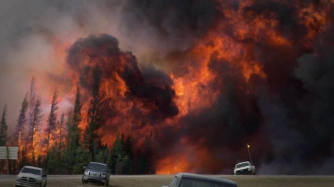


6 Wildfire Damages 6


7 Former Process 160 sq. km 60 sq.ml 1. Each morning Emergency Operations review the active and new wild fires for that day using the BC Wildfire Service web map. 2. They zoom into a wild fire location on the map. 3. They use the location and go to the GIS to plot the wild fire location. 4. They determine the impact of the fire on any FortisBC asset (stations, pipelines, towers and buildings). 5. If a wild fire is close to an asset they notify the Operations Managers so they can take immediate action. 6. It is a cumbersome manual process and staff may overlook a wild fire being close to an asset that may pose a threat 7


8 New Process 8
9 Wildfire data is GIS ready Data Format Data Structure FIRE_NUMBE VERSION_NU FIRE_SIZE_ SOURCE TRACK_DATE LOAD_DATE FEATURE_CO FIRE_STAT FIRE_NTFIRE_NT_NM FIRE_NT_LK G Non-correcte 19/05/ /05/2016 JA Active 586 Beatton Airpo/WildfireNews/OneFire.asp?ID=586 G Non-correcte 19/04/ /04/2016 JA Not Active 585 Attachie /WildfireNews/OneFire.asp?ID=585 G Non-correcte 19/04/ /04/2016 JA Not Active 582 Charlie Lake /WildfireNews/OneFire.asp?ID=582 G Non-correcte 02/06/ /06/2016 JA Active 593 Siphon Creek/WildfireNews/OneFire.asp?ID=593 G Non-correcte 22/05/ /05/2016 JA Not Active 596 Halfway River/WildfireNews/OneFire.asp?ID=596 9


10 Work Flow Wildfire Branch Wildfire Data Run 5AM FME Server FortisBC Assets FortisBC Landbase Other Data Sets GSA Data Server GSA Lite Emergency Operations Wildfire Notes Critical Infrastructure Foreign Utility Data Plots Reports KMZ files 10

11 FME Work Space 11


12 Wildfire Data Size: 30x30 km 20x20 miles 12


13 Wildfire GIS Ready Data 13


14 FortisBC Pipelines, Stations and Towers 14


15 Wild Fires within 10 km of an Asset 15


16 Wild Fires Analysis 16

17 Export data to Excel and Kml 17


18 Create Wildfire Reports 18


19 Wildfire Reports 19


20 Web Tools 20


21 Web Tools 21
22 Conclusion Wild fires pose a significant threat to pipelines, stations and building Wild fires can move very fast so analyzing the most current wild fire data is critical GIS Analysis tools provide great benefits to determine which fires could pose a risk Export the analysis and create reports and plots for first responders Provide up to date information on a daily basis Web cams and additional web tools can be very useful to assist with an emergency 22
23 Questions Contact Information Piet Nooij FortisBC GIS Technology Manager Phone (604) Mobile (604)
24 Resources British Government Wildfire Service Wildfire of Note FIRE_NUMBER=G80046 FIRE_NT_ID=586 FIRE_NT_NM=Beatton Airport FIRE_NT_LK=web link 24
Safety Regions, GIS and DM & Better SA by improved textual- & spatial visualisation. Jaap Smit Information Manager GEO, Safety Region IJsselland
 Safety Regions, GIS and DM & Better SA by improved textual- & spatial visualisation Jaap Smit Information Manager GEO, Safety Region IJsselland The Netherlands Area: 41,543 km 2 16,039 sq. mi Population:
Sharing GIS to Empower the End User David Wray, Roanoke County, Virginia
 Sharing GIS to Empower the End User David Wray, Roanoke County, Virginia Sharing GIS to Empower the End User Roanoke County, Virginia Roanoke County, Virginia Population: 92,901 Area: 251 Square Miles
STATE GEOGRAPHIC INFORMATION DATABASE
 STATE GEOGRAPHIC INFORMATION DATABASE Data Information and Knowledge Management STATE GEOGRAPHIC INFORMATION DATABASE EXECUTIVE SUMMARY Utah has developed one of the most comprehensive statewide GIS resources
A Utility s Response and Recovery. Marc Butts Southern Company 03/19/2014
 A Utility s Response and Recovery Marc Butts Southern Company 03/19/2014 Service territory across four states: 120,000 square miles Serves approximately 4 million customers Other Subsidiaries: Southern
Presentation On GIS. Tarun Batra HoG-GIS Dhruba Banerjee - Team lead (Technical)
") Presentation On GIS Tarun Batra HoG-GIS Dhruba Banerjee - Team lead (Technical) Presentation Outline What is GIS? TPDDL s GIS Journey Component of GIS Project Phase of GIS GIS Applications GIS Landscape
Presentation On GIS Tarun Batra HoG-GIS Dhruba Banerjee - Team lead (Technical) Presentation Outline What is GIS? TPDDL s GIS Journey Component of GIS Project Phase of GIS GIS Applications GIS Landscape
UTAH S STATEWIDE GEOGRAPHIC INFORMATION DATABASE
 UTAH S STATEWIDE GEOGRAPHIC INFORMATION DATABASE Data Information and Knowledge Management NASCIO Awards 2009 STATE GEOGRAPHIC INFORMATION DATABASE B. EXECUTIVE SUMMARY Utah has developed one of the most
USING TECHNOLOGY TO SHARE GIS David Wray, Roanoke County, Virginia
 USING TECHNOLOGY TO SHARE GIS David Wray, Roanoke County, Virginia Using Technology to Share GIS Roanoke County, Virginia Roanoke County, Virginia Population: 92,901 Area: 251 Square Miles Protected Areas:
Empowering water/wastewater network management with GIS
 Empowering water/wastewater network management with GIS Ioannis Kavouras_GIS Manager Surveying Engineer, MSc, MBA The Company responsible for fresh water distribution & sanitation serving 1.500.000 citizens
Peterborough Distribution Inc Ashburnham Drive, PO Box 4125, Station Main Peterborough ON K9J 6Z5
 Peterborough Distribution Inc. 1867 Ashburnham Drive, PO Box 4125, Station Main Peterborough ON K9J 6Z5 November 15, 2017 Ontario Energy Board PO Box 2319 27 th Floor, 2300 Yonge St Toronto ON M4P 1E4
UNION SANITARY DISTRICT
 UNION SANITARY DISTRICT UNION CITY, CA GIS Application of Wastewater Treatment Plant Infrastructure Union Sanitary District Regional Wastewater District Serve the cities of Fremont, Newark and Union City
No. of Days. ArcGIS 3: Performing Analysis ,431. Building 3D cities Using Esri City Engine ,859
 What s New? Creating Story Maps with ArcGIS Field Data Collection and Management Using ArcGIS Get Started with Insights for ArcGIS Introduction to GIS Using ArcGIS & ArcGIS Pro: Essential Workflow Migrating
No. of Days. ArcGIS Pro for GIS Professionals ,431. Building 3D cities Using Esri City Engine ,859
 What s New? Creating Story Maps with ArcGIS Field Data Collection and Management Using ArcGIS Get Started with Insights for ArcGIS Introduction to GIS Using ArcGIS & ArcGIS Pro: Essential Workflow Migrating
Southern California Edison Wildfire Mitigation & Grid Resiliency
 Southern California Edison Wildfire Mitigation & Grid Resiliency California State Legislative Conference Committee on Wildfire Preparedness and Response August 7, 2018 CALIFORNIA S WILDFIRE RISK Year-Round
Integration of ArcFM UT with SCADA, SAP, MAXIMO and Network Calculation
 Integration of ArcFM UT with SCADA, SAP, MAXIMO and Network Calculation Peter Harabin (VSE) Martin Mydliar (ArcGEO) July 9, 2013 Esri International User Conference Agenda > Business/process part = WHAT
Outline. What is MapPlace? MapPlace Toolbar & PopUp Menu. Geology Themes 1:5M 1:1M BCGS 1:250,000. Terranes
 Outline BRITISH COLUMBIA Overview and Explore MapPlace Website Data Delivery & Map Themes Data Sources & Updates Feature Topics New Data & Maps New MINFILE Online Exploration Assistant with Image Analysis
How Graphic Representations of Outages at Alabama Power Are Made Simple
 How Graphic Representations of Outages at Alabama Power Are Made Simple Presentation Overview This presentation will discuss the steps we took at Alabama Power using GIS to create a couple of different
GIS at the Regional District
 GIS at the Regional District Amanda Spendiff Outline Introduction What is a Regional District? Our GIS department What does the GIS department do? Data management & mapping 9-1-1 fire/dispatch support
GIS Functions and Integration. Tyler Pauley Associate Consultant
 GIS Functions and Integration Tyler Pauley Associate Consultant Contents GIS in AgileAssets products Displaying data within AMS Symbolizing the map display Display on Bing Maps Demo- Displaying a map in
Exploring GIS Potential for Northwestern Ontario Land Information Ontario
 Exploring GIS Potential for Northwestern Ontario Land Information Ontario May 13, 2015 The LIO Vision LIO Vision: That all geographic information about Ontario is fully integrated and accessible LIO Goal:
Comprehensive Emergency Management Plan
 Comprehensive Emergency Management Plan Section 6- Severe Weather/Wildfire Annex Blank Intentionally 2 CEMP Annex 6 11 Severe Weather / Wildfire Annex I. PURPOSE This plan outlines the procedures to be
Law Enforcement Solutions and Applications
 ArcGIS for Solutions and Applications Solutions and Applications ArcGIS for Platform ArcGIS for Collection of solutions and applications for law enforcement. Built on the ArcGIS platform. For any named
Leveraging ArcGIS Online Elevation and Hydrology Services. Steve Kopp, Jian Lange
 Leveraging ArcGIS Online Elevation and Hydrology Services Steve Kopp, Jian Lange Topics An overview of ArcGIS Online Elevation Analysis Using Elevation Analysis Services in ArcGIS for Desktop Using Elevation
No. of Days. Building 3D cities Using Esri City Engine ,859. Creating & Analyzing Surfaces Using ArcGIS Spatial Analyst 1 7 3,139
 Q3 What s New? Creating and Editing Data with ArcGIS Pro Editing and Maintaining Parcels Using ArcGIS Spatial Analysis Using ArcGIS Pro User Workflows for ArcGIS Online Organizations Q3-2018 ArcGIS Desktop
Copernicus Overview. Major Emergency Management Conference Athlone 2017
 Copernicus Overview Major Emergency Management Conference Athlone 2017 Copernicus is a European programme implemented by the European Commission. The services address six thematic areas: land, marine,
Application of GIS Technologies in maintenance and development of a Gas Transmission System
 Application of GIS Technologies in maintenance and development of a Gas Transmission System by Iva Juretić and Vanja Skopljak Štulić The main role of GIS, in addition to providing spatial data, is to create
GIS Monroe Geographic Information System March 14, 2018
 GIS Monroe Geographic Information System March 14, 2018 Goals Maintain Enterprise/County-wide geo-database Increase spatial accuracy of data Build and acquire more data layers Increase use of GIS; as another
TRANSVERSE GIS FOR TOTAL E&P NIGERIA - GEOPS
 TRANSVERSE GIS FOR TOTAL E&P NIGERIA - GEOPS Marc Roussel / Total H. ANEKE (Manager Survey & Geomatics) J-M. AMOUROUX (Head of Geomatics and Affiliate Transverse GIS Coordinator) TEPNG/TS/ECP/Survey &
EMMA : ECDC Mapping and Multilayer Analysis A GIS enterprise solution to EU agency. Sharing experience and learning from the others
 EMMA : ECDC Mapping and Multilayer Analysis A GIS enterprise solution to EU agency. Sharing experience and learning from the others Lorenzo De Simone, GIS Expert/ EMMA Project Manager 2014 GIS Workshop,
Applications of Map Book Software for Local Government Agencies. Melisa Bowman Lincoln Parish GIS
 Applications of Map Book Software for Local Government Agencies Melisa Bowman Lincoln Parish GIS North Central Louisiana Parish 472 Square Miles Population: 42,000 Ruston: Largest Municipality Home to
Environmental Hazard & Safety Facility Mapping Using Data Driven Pages. Kathi Cotney, GISP Lead Consultant-Spatial Analysis, Inc.
 Environmental Hazard & Safety Facility Mapping Using Data Driven Pages Kathi Cotney, GISP Lead Consultant-Spatial Analysis, Inc. WHY EHS FACILITY SITE MAPS? National Fire Protection Association (NFPA)
Canada were caused by lightning while across western and northern Canada, approximately 70% of forest fires are caused by Lightning.
 We have not seen rates of this magnitude to date. A rate of 25,000 flashes per hour will occur 5-15 times a year, usually in the afternoon. Typically since 1998 the CLDN detects 2-4 Million Flashes to
GIS Integration to Maximo
 GIS Integration to Maximo Tuesday 15 th January 2008 Mahmoud Jaafar Systems Director GISTEC Agenda Introduction Why AMS & GIS Integration? ESRI GIS Enabling Technology. Integrating GIS & Maximo. What do
Coastal Viewer Mapping Application:
 Coastal Viewer Mapping Application: MAPPING OF COASTAL PUBLIC PROPERTY, THE COASTAL PROTECTION ZONE BOUNDARIES AND AUDITING OF STRUCTURES ON THE COASTAL PUBLIC PROPERTY 15 May 2014 INTEGRATED COASTAL MANAGEMENT
Daily Operations Briefing. Friday, October 6, :30 a.m. EDT
 Daily Operations Briefing Friday, October 6, 2017 8:30 a.m. EDT Significant Activity Oct 5-6 Significant Events: Response for Hurricane Maria, Preparations for Tropical Storm Nate Tropical Activity: Atlantic
GIS at JLAB. T. Larrieu Jefferson Lab, Newport News, VA 23606, USA. Controls Group. October 2006 PCaPAC
 GIS at JLAB T. Larrieu Jefferson Lab, Newport News, VA 23606, USA October 2006 PCaPAC Jefferson Lab has a Large and Complex Infrastructure CEBAF ( 24/7 electron utility ) 7 km of beamline 2000+ magnets
PUBLIC SAFETY POWER SHUTOFF POLICIES AND PROCEDURES
 PACIFIC GAS AND ELECTRIC COMPANY PUBLIC SAFETY POWER SHUTOFF POLICIES AND PROCEDURES SEPTEMBER 2018 1 PACIFIC GAS AND ELECTRIC COMPANY PUBLIC SAFETY POWER SHUTOFF POLICIES AND PROCEDURES SEPTEMBER 2018
National Public Weather and Warning Services in the Swaziland Meteorological Service Dennis S.Mkhonta /
 National Public Weather and Warning Services in the Swaziland Meteorological Service Dennis S.Mkhonta dennis.mkhonta@gmail.com / dennis@swazimet.gov.sz Introduction Swaziland s geographical position exposes
WELCOME & INTRODUCTIONS
 GIS Monroe Geographic Information System January 31, 2018 WELCOME & INTRODUCTIONS Chip Thomas, Ritter GIS Sarah Schrader, Acct. Mgr., ESRI Chris Beyett, Solutions Engineer, ESRI Colleen Hinzmann, IT Director,
GIS Emergency Management for the University of Redlands
 GIS Emergency Management for the University of Redlands ESRI International User Conference 2003 Paper Submission Paper Number: 1178 By: Kevin Johnson Abstract In times of crisis, the President and other
Damage and Restoration of Drinking Water Systems Caused by 0206 Tainan Earthquake and Future Mitigation Measures
 Damage and Restoration of Drinking Water Systems Caused by 0206 Tainan Earthquake and Future Mitigation Measures Nan-Tzer Hu 1. Overview of 0206 Earthquake s At 03:57 local time (19:57 UTC) on 6 February
Presentation of the gicases case studies Carlo Cipolloni ISPRA Giorgio Saio GISIG Dirk Frigne GEOSPARC Elena Krikigianni EPSGR
 Presentation of the gicases case studies Carlo Cipolloni ISPRA Giorgio Saio GISIG Dirk Frigne GEOSPARC Elena Krikigianni EPSGR 1 Which are the gicases Case study? CS1 - Use of indoor GIS in healthcare
Outline Brief Overview MapPlace Website Data Delivery & Map Themes Digital Geology
 BRITISH COLUMBIA GEOLOGICAL SURVEY Kirk Hancock Pat Desjardins Nick Massey BRITISH COLUMBIA Ministry of Energy and Mines Ward Kilby acknowledged developer of MapPlace Outline Brief Overview MapPlace Website
United States Forest Service Makes Use of Avenza PDF Maps App to Reduce Critical Time Delays and Increase Response Time During Natural Disasters
 CASE STUDY For more information, please contact: Christine Simmons LFPR Public Relations www.lfpr.com (for Avenza) 949.502-7750 ext. 270 Christines@lf-pr.com United States Forest Service Makes Use of Avenza
Overview. Everywhere. Over everything.
 Cadenza Desktop Cadenza Web Cadenza Mobile Cadenza Overview. Everywhere. Over everything. The ultimate GIS and reporting suite. Provide, analyze and report data efficiently. For desktop, web and mobile.
One platform for desktop, web and mobile
 One platform for desktop, web and mobile Search and filter Get access to all data thematically filter data in context factually and spatially as well as display it dynamically. Export a selection or send
Engineering ABSTRACT. GIS Visualization of electrical network in Kurdistan Region for smart phones. Ismael Khorshed Abdulrahman Salar Kheder Shaikhah
 GIS Visualization of electrical network in Kurdistan Region for smart phones Engineering KEYWORDS : Ismael Khorshed Abdulrahman Salar Kheder Shaikhah ABSTRACT Assistant Lecturer at: Hawler Polytechnic
The Emerging Role of Enterprise GIS in State Forest Agencies
 The Emerging Role of Enterprise GIS in State Forest Agencies Geographic Information System (GIS) A geographic information system (GIS) is a computer software system designed to capture, store, manipulate,
Geo-enabling a Transactional Real Estate Management System A case study from the Minnesota Dept. of Transportation
 Geo-enabling a Transactional Real Estate Management System A case study from the Minnesota Dept. of Transportation Michael Terner Executive Vice President Co-author and Project Manager Andy Buck Overview
Bridging the Gap between Engineering and GIS
 Bridging the Gap between Engineering and GIS Presented by: Karen Stewart, B.Tech, GISP Manager of Geomatics Township of Langley February 13, 2006 Agenda Introduction History Goals Implementation Benefits
B.2 Sources for Hazard Identification, Profiling, and Ranking (Section 3) Overview of Sussex County s History of Hazards
 Overview of Sussex County s History of Hazards") Appendix B Sources B.1 Sources for Planning Process (Section 2) FEMA. Mitigation Planning Guidance (386 Series). Available on the web at: http://www.fema.gov/plan/mitplanning/planning_resources.shtm FEMA
Appendix B Sources B.1 Sources for Planning Process (Section 2) FEMA. Mitigation Planning Guidance (386 Series). Available on the web at: http://www.fema.gov/plan/mitplanning/planning_resources.shtm FEMA
Geospatial Fire Behavior Modeling App to Manage Wildfire Risk Online. Kenyatta BaRaKa Jackson US Forest Service - Consultant
 Geospatial Fire Behavior Modeling App to Manage Wildfire Risk Online Kenyatta BaRaKa Jackson US Forest Service - Consultant Fire Behavior Modeling and Forest Fuel Management Modeling Fire Behavior is an
Outside of the Box Integrations
 Outside of the Box Integrations Improve Asset Management with Localization September 8, 2017 2107 Esri GeoConX Conference Introductions Jason Dietrich CoServ GIS Analyst SDE Administration ArcGIS Online
ArcGIS for Local Government
 Wednesday, June 29th ArcGIS for Local Government Dan Rose, GIS Analyst WaterOne IT/GIS Agenda / Talking Points What is the LGIM? WaterOne s GIS and LGIM background Our geodatabase redesign Our strategies
National Survey on the Natural Environment of Japan. Hajime Hirosawa Biodiversity Center of Japan Ministry of the Environment (MOE)
") National Survey on the Natural Environment of Japan Hajime Hirosawa Biodiversity Center of Japan Ministry of the Environment (MOE) Biodiversity Center of Japan, MOE Establishment: 1998 Purpose: to encourage
National Survey on the Natural Environment of Japan Hajime Hirosawa Biodiversity Center of Japan Ministry of the Environment (MOE) Biodiversity Center of Japan, MOE Establishment: 1998 Purpose: to encourage
Introduction to GIS. Geol 4048 Geological Applications of Remote Sensing
 Introduction to GIS Geol 4048 Geological Applications of Remote Sensing GIS History: Before Computers GIS History Using maps for a long time Dr. Roger F. Tomlinson Father of GIS He was an English geographer
Jim Fox. copyright UNC Asheville's NEMAC
 Decisions and System Thinking Jim Fox November, 2012 1 UNC Asheville s s NEMAC National Environmental Modeling and Analysis Center Applied Research and technology development on integration of environmental
Lesson: Don t Wait For the Storm
 Lesson: Don t Wait For the Storm Developing a GIS for Plaquemines Parish, Louisiana Presented by: Daniel Mellott, GISP Burk Kleinpeter, Inc. Where is Plaquemines Parish? 1998 GIS Feasibility Study User
ÖBB Natural Hazard Management
 ÖBB Natural Hazard Management Management of Weather Events in the Austrian Federal Railways MOWE-IT, Brussels 17 th of September 2013 DI Günther Kundela Integrated Track Management Integration Technic
Watershed Application of WEPP and Geospatial Interfaces. Dennis C. Flanagan
 Watershed Application of WEPP and Geospatial Interfaces Dennis C. Flanagan Research Agricultural Engineer USDA-Agricultural Research Service Adjunct Professor Purdue Univ., Dept. of Agric. & Biol. Eng.
Winter Preparation for Severe Weather Events
 Winter Preparation for Severe Weather Events Jule Tate, Associate Director, Event Analysis Richard Hackman, Senior Reliability Advisor, Reliability Risk Management Mark Olson, Senior Engineer, Reliability
AIRNow and AIRNow-Tech
 AIRNow and AIRNow-Tech Dianne S. Miller and Alan C. Chan Sonoma Technology, Inc. Petaluma, California Presented to the National Tribal Forum Spokane, Washington June 15, 2011 910216-4140 Outline Overview
Corporate. Information. Railway Infrastructure Administrator. Year indracompany.com
 geospatial and mobility Corporate Geographic Information System of ADIF Railway Infrastructure Administrator. Year 2009-2010 Corporate Geographic Information System of ADIF ADIF. Spanish Administrator
Geo-information and Disaster Risk Reduction in the Hindu Kush-Himalayan region
 Geo-information and Disaster Risk Reduction in the Hindu Kush-Himalayan region Basanta Shrestha, Division Head MENRIS, International Centre for Integrated Mountain Development Kathmandu, Nepal The International
The University of Arizona Enterprise GIS. CFTA 2016 Facilities Geospatial Technologies Showcase
 The University of Arizona Enterprise GIS CFTA 2016 Facilities Geospatial Technologies Showcase Main Campus: Tucson, Arizona Founded: 1885 Number of Buildings: 227 GSF: 9.4 million Acres: 393 Total Students:
Humanitarian Assistance and Disaster Relief (HADR)
") Humanitarian Assistance and Disaster Relief (HADR) Remote sensing, GIS & Server Technology for Planning, Response & Mitigation Jonathan Lee Hon Yip Senior Technical Sales, Intergraph Security, Government
Humanitarian Assistance and Disaster Relief (HADR) Remote sensing, GIS & Server Technology for Planning, Response & Mitigation Jonathan Lee Hon Yip Senior Technical Sales, Intergraph Security, Government
1 Complementary Access Tools
 ENERGY IHS AccuMap Shaped by industry and powered by IHS Markit information, AccuMap is a powerful and intuitive interpretation solution for the Canadian Energy Industry. 1 Complementary Access Tools AccuLogs
VISIT MISSISSIPPI GULF COAST CRISIS COMMUNICATION MANUAL 2016
 VISIT MISSISSIPPI GULF COAST CRISIS COMMUNICATION MANUAL 2016 This manual was prepared for Visit Mississippi Gulf Coast staff in the event of a crisis, and will help to distinguish the appropriate course
ELF products in the ArcGIS platform
 ELF products in the ArcGIS platform Presentation to: Author: Date: NMO Summit 2016, Dublin, Ireland Clemens Portele 18 May 2016 The Building Blocks 18 May, 2016 More ELF users through affiliated platforms
GI Technology for Disaster Management
 GI Technology for Disaster Management 17 th ICC on the Regional Space Applications Programme for Sustainable Development (RESAP) 26 th Nov 2013 Bangkok Thailand Period and time of seasonal in thailand
BVES Annual Reliability Public Presentation 2016 Performance
 BVES Annual Reliability Public Presentation 2016 Performance December 13, 2017 Agenda Company Overview What is Electric Utility Reliability? Requirements & Definitions Reliability Indices 2016 Reliability
Enabling ENVI. ArcGIS for Server
 Enabling ENVI throughh ArcGIS for Server 1 Imagery: A Unique and Valuable Source of Data Imagery is not just a base map, but a layer of rich information that can address problems faced by GIS users. >
NATO Headquarters The Situation Center GIS experience.
 NATO Headquarters The Situation Center GIS experience. Abstract Recently, the dynamic capability of responding to a major world crisis with comprehensive in-depth information has become a crucial aspect
Oakland County Parks and Recreation GIS Implementation Plan
 Oakland County Parks and Recreation GIS Implementation Plan TABLE OF CONTENTS 1.0 Introduction... 3 1.1 What is GIS? 1.2 Purpose 1.3 Background 2.0 Software... 4 2.1 ArcGIS Desktop 2.2 ArcGIS Explorer
BCeMap A Multi Agency Situational Awareness System for the Province of BC
 BCeMap A Multi Agency Situational Awareness System for the Province of BC URISA BC Gurdeep Singh Manager, Business Development & Partnership Portfolio Integrated Land Management Bureau, GeoBC Kristopher
ArcGIS Pipeline Referencing An Introduction. Anjali Bhangay William Isley
 ArcGIS Pipeline Referencing An Introduction Anjali Bhangay William Isley Pipeline Referencing Overview Information Model Pipeline Referencing Overview Information Model ArcGIS Pro Pipeline Referencing
Features and Benefits
 Autodesk LandXplorer Features and Benefits Use the Autodesk LandXplorer software family to help improve decision making, lower costs, view and share changes, and avoid the expense of creating physical
SECONDARY ROADS LEVERAGING ENTERPRISE GIS. Secondary Road Department & GIS Department Linn County, Iowa April 20, 2015
 SECONDARY ROADS LEVERAGING ENTERPRISE GIS Secondary Road Department & GIS Department Linn County, Iowa April 20, 2015 Brad Ketels, P.E. Linn County Assistant Engineer Matt Boyle, GISP Linn County GIS Analyst
Southern California Edison ESRB-8 Report Regarding Pro-Active De-Energization Event December 29 to January 1, 2019
 Southern California Edison Submitted to: California Public Utilities Commission Director of the Safety and Enforcement Division January 15, 2019 Southern California Edison (SCE) submits the following report
Crime Analysis. GIS Solutions for Intelligence-Led Policing
 Crime Analysis GIS Solutions for Intelligence-Led Policing Applying GIS Technology to Crime Analysis Know Your Community Analyze Your Crime Use Your Advantage GIS aids crime analysis by Identifying and
Leveraging the GIS Capability within FlexiCadastre
 Managing Local Land Concerns, Maintaining Corporate Governance Leveraging the GIS Capability within FlexiCadastre Regional User Conference, North America May 6 th May 9 th, 2013 Cameron McKellar, Technical
HIGH RESOLUTION BASE MAP: A CASE STUDY OF JNTUH-HYDERABAD CAMPUS
 HIGH RESOLUTION BASE MAP: A CASE STUDY OF JNTUH-HYDERABAD CAMPUS K.Manjula Vani, Abhinay Reddy, J. Venkatesh, Ballu Harish and R.S. Dwivedi ABSTRACT The proposed work High Resolution Base map: A Case study
ARCGIS PRO COURSE, APPLIED TO ENVIROMENTAL MANAGEMENT GIS. Course. Training. .com
 ARC PRO COURSE, APPLIED TO ENVIROMENTAL MANAGEMENT TYC Training Course.com TRAINING OVERVIEW This Arc Pro online course will provide a great deal of information about the link between earth s ecosystems
SANTA CLARA COUNTY THEMATIC ATLAS
 1 SANTA CLARA COUNTY THEMATIC ATLAS Project Overview Douglas Schenk, GIS Analyst Sampa Patra, GIS Analyst Making the Thematic Atlas 2 Brought to you by the County of Santa Clara Public Health Department,
PRRD Fires, Floods & Drought
 PRRD Fires, Floods & Drought Welcome to the Peace! Fort St John Hudson s Hope Area = 12 million hectares (120,000 km 2 ) Approximately 15% of the Province of BC 7 municipaliies, 4 electoral areas BC Stats
Fort Lauderdale s GIS Supports Response to. Hurricane Irma
 Fort Lauderdale s GIS Supports Response to Hurricane Irma By Monica Pratt, ArcUser Editor When Hurricane Irma first made landfall in the Florida Keys on September 10, 2017, it brought destructive 70 mph
May 31, Flood Response Overview
 May 31, 2013 Flood Response Overview Suppression 867 Personnel on three (3) shifts 289 Red Shift (A) 289 Blue Shift (B) 289 Green Shift (C) Department Overview Department Overview EMS: 40,934 False Alarm:
Mapping of Sewerage System of Aurangabad City using GIS Software
 Mapping of Sewerage System of Aurangabad City using GIS Software Amol Adhave, Sachin Bajaj M.Tech Student, Department of CS & IT, Dr.Babasaheb Ambedkar Marathwada University, Aurangabad, Maharashtra, India
Office of Technology Partnerships GIS Collaboration
 Office of Technology Partnerships GIS Collaboration State GIS Update April 21, 2017 Mark Holmes, GISP Outline MGF Upgrade Project Census Programs Imagery Update LiDAR Update Open Discussion 2 MGF Background
INSPIRE implementation in the Turkish Ministry of Environment and Urbanization Producing and Publishing Environmental Data
 INSPIRE implementation in the Turkish Ministry of Environment and Urbanization Producing and Publishing Environmental Data Ezgi Sarmusak Urban Planner, MoEU Sibel Süer Toybıyık - Assistant Expert, MoEU
Staging for Utility Personnel and Mutual Aid. 1. Hermine- Meeting dates were August 29th_31 st, 2016 and September 1st, 2016.
 Town of Havana, Fl. Response to Review of Electric Utility Hurricane Preparedness and Restoration Actions- Applies only to Hermine and Irma. Maria and Nate posed no serious threat to Havana. Staging for
Road Ahead: Linear Referencing and UPDM
 Road Ahead: Linear Referencing and UPDM Esri European Petroleum GIS Conference November 7, 2014 Congress Centre, London Your Work Making a Difference ArcGIS Is Evolving Your GIS Is Becoming Part of an
Connecting Communities. Jeff Peters - Esri
 Connecting Communities Jeff Peters - Esri Public Safety and Security Infrastructure Protection Officer Involved Shootings and Violent Crimes DHS Police Foundation Operation Centers Mail Theft Live Incident
United States Multi-Hazard Early Warning System
 United States Multi-Hazard Early Warning System Saving Lives Through Partnership Lynn Maximuk National Weather Service Director, Central Region Kansas City, Missouri America s s Weather Enterprise: Protecting
THE STUDY ON 4S TECHNOLOGY IN THE COMMAND OF EARTHQUAKE DISASTER EMERGENCY 1
 THE STUDY ON 4S TECHNOLOGY IN THE COMMAND OF EARTHQUAKE DISASTER EMERGENCY 1 Zhou Wensheng 1, Huang Jianxi 2, Li Qiang 3, Liu Ze 3 1 Associate Professor, School of Architecture, Tsinghua University, Beijing.
Construction in my Neighborhood - Communication with Stakeholder and Public -
 Construction in my Neighborhood - Communication with Stakeholder and Public - Presented by: Navneet Virk East Bay Municipal Utility District, Oakland, CA 0 Mission at EBMUD To manage the natural resources
Trainee Manual C02 CITY OF SASKATOON. Water and Sewer Section. Severe Storm Response Trainee Manual. Version # 1-0-3
 Trainee Manual C02 CITY OF SASKATOON Water and Sewer Section Severe Storm Response Trainee Manual CITY OF SASKATOON Severe Storm Response Trainee Manual City of Saskatoon Severe Storm Response Trainees
Mapping Your Land and Introduction to Web Soil Survey. Elizabeth Cook GIS Specialist USDA-NRCS (retired)
") Mapping Your Land and Introduction to Web Soil Survey Elizabeth Cook GIS Specialist USDA-NRCS (retired) Using Geographic Information Systems (GIS), Global Positioning System (GPS), digital aerial photography
Mapping Your Land and Introduction to Web Soil Survey Elizabeth Cook GIS Specialist USDA-NRCS (retired) Using Geographic Information Systems (GIS), Global Positioning System (GPS), digital aerial photography
Enhancing Decision-Making with the Alberta Modelling Expert System (MES) Presented by: Chiadih Chang September 12 th, 2017
 Presented by: Chiadih Chang September 12 th, 2017") Enhancing Decision-Making with the Alberta Modelling Expert System (MES) Presented by: Chiadih Chang September 12 th, 2017 Organization Overview Alberta Environment and Parks - Vision: A healthy and clean
Enhancing Decision-Making with the Alberta Modelling Expert System (MES) Presented by: Chiadih Chang September 12 th, 2017 Organization Overview Alberta Environment and Parks - Vision: A healthy and clean
First on the Ground. Geomatics
 First on the Ground Geomatics Surveying and mapping solutions spanning the entire project lifecycle Part art, part science, part technology, the Geomatics profession is constantly evolving. From the very
A Technique for Importing Shapefile to Mobile Device in a Distributed System Environment.
 A Technique for Importing Shapefile to Mobile Device in a Distributed System Environment. 1 Manish Srivastava, 2 Atul Verma, 3 Kanika Gupta 1 Academy of Business Engineering and Sciences,Ghaziabad, 201001,India