Applications of Map Book Software for Local Government Agencies. Melisa Bowman Lincoln Parish GIS
|
|
|
- Job Nichols
- 5 years ago
- Views:
Transcription
1 Applications of Map Book Software for Local Government Agencies Melisa Bowman Lincoln Parish GIS

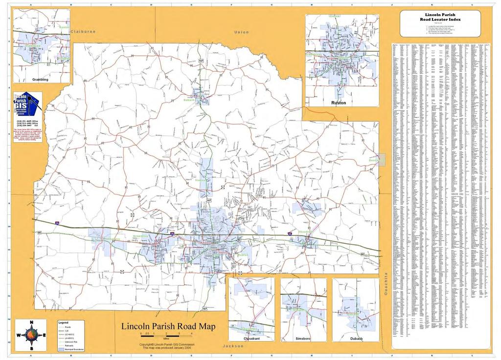
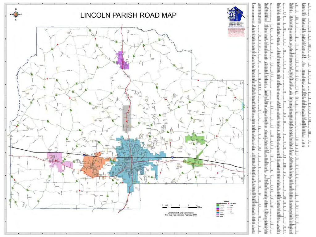
2 North Central Louisiana Parish 472 Square Miles Population: 42,000 Ruston: Largest Municipality Home to Louisiana Tech University and Grambling State University
3 Lincoln Parish GIS Commission Group of local government agencies that joined together in 1993 to create a commission to meet the GIS needs of each member agency and promote the use of GIS in Lincoln Parish. GIS Commission Members: Assessor City of Ruston Clerk of Court Communications District (911) Fire Protection District Police Jury Sheriff
4 Meeting the Needs of Member Agencies Data & Services Software Utilized create & maintain data store data make data available to GIS members and to the public in a useable format analyze data display data in standard and custom maps provide instruction and technical assistance to members seek new technologies to help members meet their needs and goals MapLogic map book software ArcFM utilities software ESRI Software & Extensions ArcInfo ArcEditor Arcview ArcPublisher/ArcReader Network Analyst ArcSDE ArcServer Image Server
5 Data Available Parish Boundary Municipal Boundaries Police Jury District & Precincts School Taxing District Justice of Peace Wards Water Districts Flood Plains Streams Railroads Road Centerlines Address Points Structure Footprints Zip Code Boundaries Oil & Gas Wells Cell Towers LIDAR Contours Public Land Survey System (PLSS) Parcels Subdivision Lots & Boundaries Parish Fire Stations & Hydrants City of Ruston City Property Zoning Future Land Use Fire Stations & Hydrants Water Meters & Lines Sewer Lines, Manholes & Lift Stations Electric Meters & Lines Aerial Photography & DOQQ
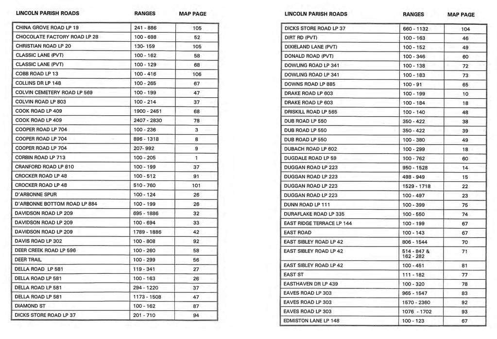
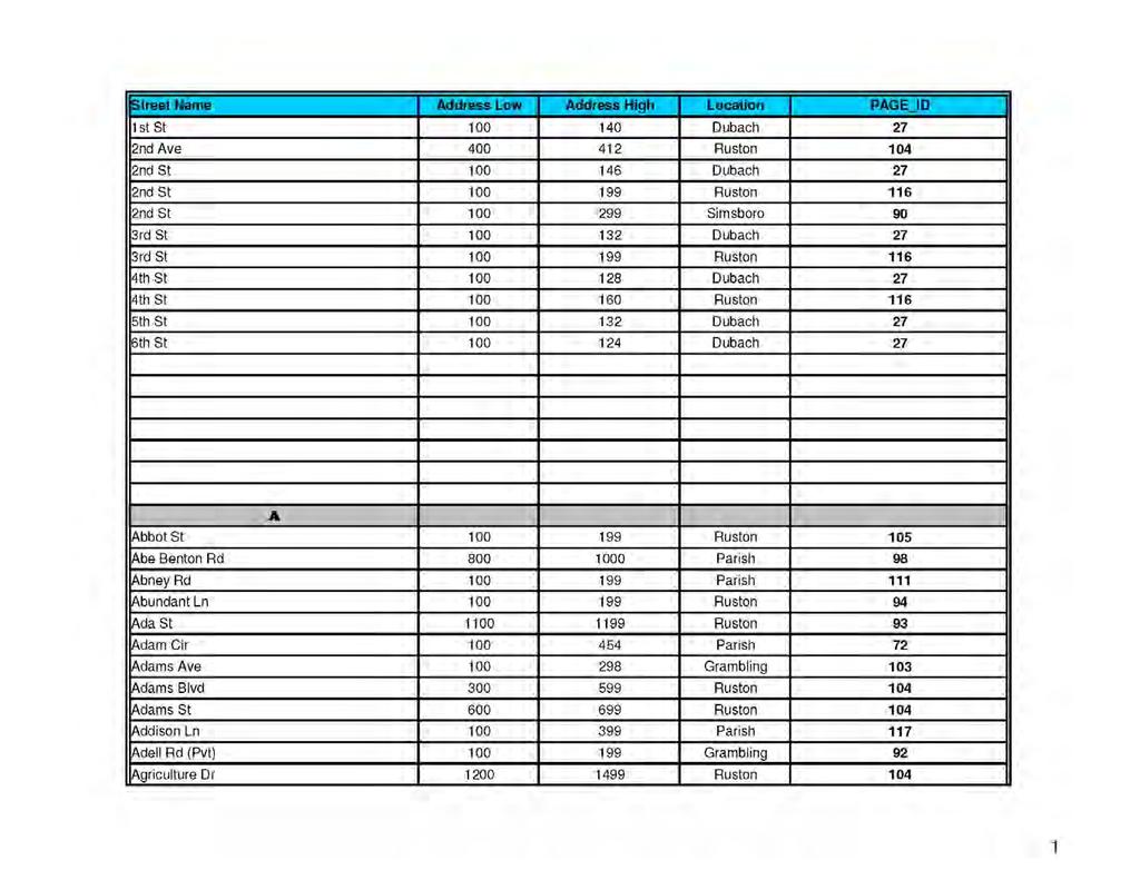
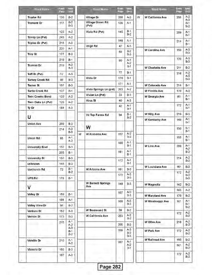
6 First Map Book created in 1997 Emergency Responders & Field Deputies DSMapBook graphically simple map book 11 x 17 road index maintained in Excel grid style page numbering
7
8
9 Second Map Book created in 2001 addressed issues of confusing page numbering and bulky size DSMapBook graphically simple map book road index maintained in Publisher 8.5 x 14 numeric page numbering
10
11
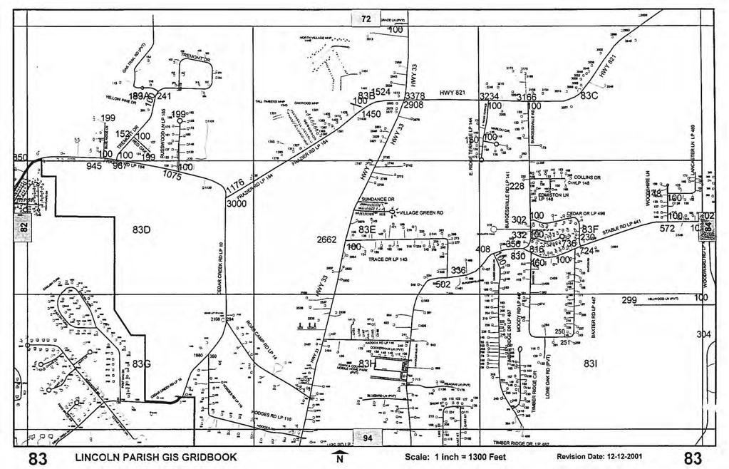
12 Third Map Book created in 2003 addressed issue of bulky size addressed issue of page numbering with location indicators DSMapBook more graphical map book road index maintained in Publisher 8.5 x 11 grid style page numbering
13
14
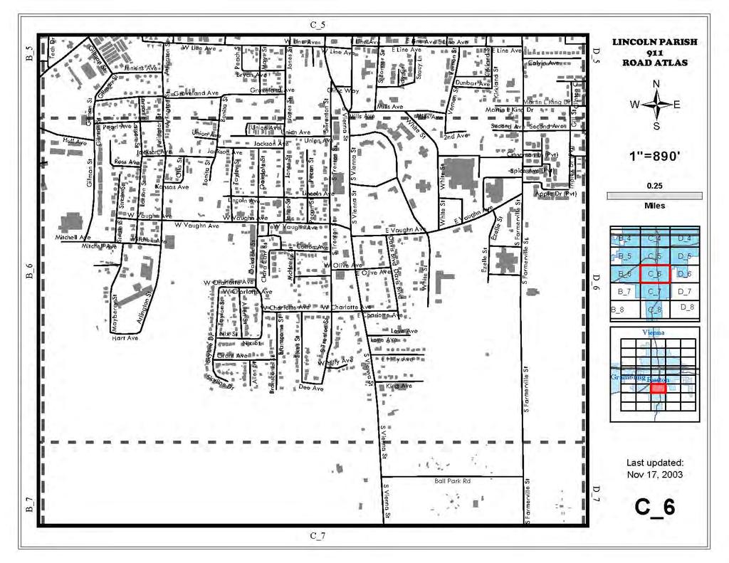
15 Current Map Book created in 2006 addresses issues of page numbering and map book index maintenance MapLogic more graphical map book road index created and maintained within map book 8.5 x 11 numeric page numbering
16
17 Road Index Maps DSMapBook MapLogic Creating the Index Was done in Publisher and added to map as an image Creating the Index Index Series is created within the map using MapLogic tools Maintaining the Index Image had to be edited in Publisher and re-inserted in the map Maintaining the Index Simply re-index the index series
18
19
20 Parcel Books Created for use in the Assessor s Office Also used by title researchers, oil & gas land men and individual landowners Grid is based on PLSS so each page represents either a section, quarter section or forty depending on density of parcels
21 Conclusion Pros: Free DSMapBook Easy to use Can be used to create map books and parcel books Cons: Some difficulty with page numbering No Index, location indicators are used instead Pros: MapLogic Creates and maintains index within the map book More tools such as index labeling options available Cons: Must purchase software Less user-friendly than DSMapBook
22 Contact Information DSMapBook Production/DSMapBook/DSMapBook.htm MapLogic Lincoln Parish GIS
E Geographic Information System. Created By: Freda Rocker Pearl River County Mapping
 E-9-1-1 Geographic Information System Created By: Freda Rocker Pearl River County Mapping frocker@pearlrivercounty.net Overview of Pearl River County E-9-1-1 Communications District GIS In 1998 the Pearl
GIS Monroe Geographic Information System March 14, 2018
 GIS Monroe Geographic Information System March 14, 2018 Goals Maintain Enterprise/County-wide geo-database Increase spatial accuracy of data Build and acquire more data layers Increase use of GIS; as another
WELCOME & INTRODUCTIONS
 GIS Monroe Geographic Information System January 31, 2018 WELCOME & INTRODUCTIONS Chip Thomas, Ritter GIS Sarah Schrader, Acct. Mgr., ESRI Chris Beyett, Solutions Engineer, ESRI Colleen Hinzmann, IT Director,
GIS. in the City of Lewiston Maine
 GIS in the City of Lewiston Maine The purpose of this slideshow is to provide an overview of the city GIS and how it is used, maintained and accessed in-house as well as by the public. Please simply hit
Lesson: Don t Wait For the Storm
 Lesson: Don t Wait For the Storm Developing a GIS for Plaquemines Parish, Louisiana Presented by: Daniel Mellott, GISP Burk Kleinpeter, Inc. Where is Plaquemines Parish? 1998 GIS Feasibility Study User
Information. Information Technology. Geographic. Services (GIS) 119 W Indiana Ave Deland, FL 32720
 119 W Indiana Ave Deland, FL 32720") Information Technology Geographic Information Services (GIS) 119 W Indiana Ave Deland, FL 32720 A GIS consists of 5 primary components: Hardware Software People Data Methods or Business Processes --- Hardware
Information Technology Geographic Information Services (GIS) 119 W Indiana Ave Deland, FL 32720 A GIS consists of 5 primary components: Hardware Software People Data Methods or Business Processes --- Hardware
Rural Louisiana. A quarterly publication of the Louisiana Tech Rural Development Center
 Rural Louisiana A quarterly publication of the Louisiana Tech Rural Development Center Volume 4, No. 1, Fall 2009 Editor: Aaron K. Lusby Director, Asst. Professor Newsletter design: Stephanie Tidwell Student
KING GEORGE COUNTY DEPARTMENT OF COMMUNITY DEVELOPMENT
 GIS REPORT 2016 KING GEORGE COUNTY DEPARTMENT OF COMMUNITY DEVELOPMENT Background The GIS (Geographic Information System) coordinator was hired in 2001 to develop a GIS for King George County. Prior to
GIS-T 2010 Building a Successful Geospatial Data Sharing Framework: A Ohio DOT Success Story
 GIS-T 2010 Building a Successful Geospatial Data Sharing Framework: A Ohio DOT Success Story ODOT District 2 GIS John Puente District 1 GIS Coordinator\ Planning Administrator 2 Interoperability 3 District
McHenry County Property Search Sources of Information
 Disclaimer: The information in this system may contain inaccuracies or typographical errors. The information in this system is a digital representation of information derived from original documents; as
Write a report (6-7 pages, double space) on some examples of Internet Applications. You can choose only ONE of the following application areas:
 on some examples of Internet Applications. You can choose only ONE of the following application areas:") UPR 6905 Internet GIS Homework 1 Yong Hong Guo September 9, 2008 Write a report (6-7 pages, double space) on some examples of Internet Applications. You can choose only ONE of the following application
UPR 6905 Internet GIS Homework 1 Yong Hong Guo September 9, 2008 Write a report (6-7 pages, double space) on some examples of Internet Applications. You can choose only ONE of the following application
Greg Collier, Battalion Chief Larry Fox, Captain Mount Laurel Fire Department
 Greg Collier, Battalion Chief Larry Fox, Captain Mount Laurel Fire Department Hurdles (NAVTEQ data Laurel Green example) Current software use map books field data (COP, OEM, disasters, critical infrastructure,
McHenry County Property Search Sources of Information
 Disclaimer: The information in this system may contain inaccuracies or typographical errors. The information in this system is a digital representation of information derived from original documents; as
GIS Geographical Information Systems. GIS Management
 GIS Geographical Information Systems GIS Management Difficulties on establishing a GIS Funding GIS Determining Project Standards Data Gathering Map Development Recruiting GIS Professionals Educating Staff
If you aren t familiar with Geographical Information Systems (GIS), you. GIS, when combined with a database that stores response information,
, you. GIS, when combined with a database that stores response information,") Geographical Information Systems in EMS By William E. Ott If you aren t familiar with Geographical Information Systems (GIS), you should take a look at what GIS can offer you as an EMS manager. GIS, when
Geographical Information Systems in EMS By William E. Ott If you aren t familiar with Geographical Information Systems (GIS), you should take a look at what GIS can offer you as an EMS manager. GIS, when
Frequently Asked Questions about MnDOT s Railroad Map Conversion Project
 Frequently Asked Questions about MnDOT s Railroad Map Conversion Project What were the main objectives of the project? What are the results and end products? What can these railroad maps be used for? Who
John Laznik 273 Delaplane Ave Newark, DE (302)
") Office Address: John Laznik 273 Delaplane Ave Newark, DE 19711 (302) 831-0479 Center for Applied Demography and Survey Research College of Human Services, Education and Public Policy University of Delaware
Office Address: John Laznik 273 Delaplane Ave Newark, DE 19711 (302) 831-0479 Center for Applied Demography and Survey Research College of Human Services, Education and Public Policy University of Delaware
MODERNIZATION OF THE MUNICIPAL MAPPING USING HIGH END GNSS SYSTEM AND GIS SOFTWARE
 MODERNIZATION OF THE MUNICIPAL MAPPING USING HIGH END GNSS SYSTEM AND GIS SOFTWARE Mr. R. A. R. Khan Assistant Engineer, Sewerage Utility Management Centre (SUMC) Municipal Corporation Of Greater Mumbai
Developing a Campus-wide Base Map for Planning, Design and Construction. June 21, 2007
 Developing a Campus-wide Base Map for Planning, Design and Construction June 21, 2007 Presenters Berent Pippert UCR Project Manager Capital and Physical Planning Academic Planning and Budget 951-827-2431
Cobb County GIS: Beyond the Map
 Cobb County GIS: Beyond the Map Charles Fail Tim Scharff Cobb County GIS SERUG 2008 1 Topics Cobb GIS Overview The Early Years Enterprise GIS Transition Putting It Together Looking Ahead SERUG 2008 2 Cobb
Providing Public Access to King County GIS Data. Presented by: Michael Jenkins King County GIS Center Seattle, WA
 Providing Public Access to King County GIS Data Presented by: Michael Jenkins King County GIS Center Seattle, WA King County, Washington Microsoft Boeing Amazon.Com Starbucks Port of Seattle Weyerhauser
 Boone County GIS has the right to inquire about and investigate the use of any requested products and deny access to anyone based on concerns relating to privacy, security, public health, public safety,
Techniques for Science Teachers: Using GIS in Science Classrooms.
 Techniques for Science Teachers: Using GIS in Science Classrooms. After ESRI, 2008 GIS A Geographic Information System A collection of computer hardware, software, and geographic data used together for
Tips and Tricks for Using ArcGIS for Fire Pre-Incident Planning Version II By: Chris Rogers Firefighter Kirkland Fire Department Kirkland Washington
 Tips and Tricks for Using ArcGIS for Fire Pre-Incident Planning Version II By: Chris Rogers Firefighter Kirkland Fire Department Kirkland Washington Abstract: The Kirkland Fire Department has been using
KING GEORGE COUNTY DEPARTMENT OF COMMUNITY DEVELOPMENT
 GIS REPORT 2017 KING GEORGE COUNTY DEPARTMENT OF COMMUNITY DEVELOPMENT Background The GIS (Geographic Information System) manager was hired in 2001 to develop a GIS for King George County. Prior to 2001,
MAPPS 2012 Geospatial Products and Services Excellence Awards Awards Entry Form
 MAPPS 2012 Geospatial Products and Services Excellence Awards 2012 Awards Entry Form Please include a copy of this document with the project/product submission Entry Information Submission Number: 1741558
Comptroller GIS and Property Data. Ken Morrell Assessment Systems Manager Division of Property Assessments February 22, 2007
 Comptroller GIS and Property Data Ken Morrell Assessment Systems Manager Division of Property Assessments February 22, 2007 Comptroller Divisions Using and Supporting GIS Office of Local Government Implement
GIS Needs Assessment. for. The City of East Lansing
 GIS Needs Assessment for The City of East Lansing Prepared by: Jessica Moy and Richard Groop Center for Remote Sensing and GIS, Michigan State University February 24, 2000 Executive Summary At the request
NR402 GIS Applications in Natural Resources
 NR402 GIS Applications in Natural Resources Lesson 1 Introduction to GIS Eva Strand, University of Idaho Map of the Pacific Northwest from http://www.or.blm.gov/gis/ Welcome to NR402 GIS Applications in
Geographic Information System Services. Strategic Plan FY
 Geographic Information System Services Strategic Plan FY 2011 2012 Drafted by: Gary Palmer, Assistant Town Manager Major Sections: History Mission, Vision, Values Strategic Issues Performance Measurement
ArcGIS Pro 3D Workflows. Zena Pelletier
 ArcGIS Pro 3D Workflows Zena Pelletier 3D as a GIS capability Core part of the platform Desktop Web Device Combine 2D and 3D in the same web GIS architecture Reuse dynamic services across clients Securely
th Ave NW Norman, OK
 2004 Oklahoma Chapter SCAUG Steering Committee Shellie Willoughby Chair Oklahoma Conservation Commission (405) 521-4828 Joyce Green Past Chair (405) 366-5467 Kate Burch Sec/Tres. Topographic Mapping (405)
Integrating GIS into West Nile Virus Planning and Surveillance
 Integrating GIS into West Nile Virus Planning and Surveillance Fairfax County Health Department Adrian Joye, Environmental Health Specialist Agenda Background/Benefits Routes/Trap Locations Dead Bird Complaint
Office of Geographic Information Systems
 Winter 2007 Department Spotlight SWCD GIS by Dave Holmen, Dakota County Soil and Water Conservation District The Dakota County Soil and Water Conservation District (SWCD) has collaborated with the Dakota
Office of Geographic Information Systems
 Office of Geographic Information Systems Print this Page Winter 2009 - Desktop GIS: The National Grid Wants You! By Todd Lusk In case of a disaster would you want emergency responders to be able to easily
Introduction. Project Summary In 2014 multiple local Otsego county agencies, Otsego County Soil and Water
 Introduction Project Summary In 2014 multiple local Otsego county agencies, Otsego County Soil and Water Conservation District (SWCD), the Otsego County Planning Department (OPD), and the Otsego County
Digital Tax Mapping Present and Future. Kurt Donaldson
 Digital Tax Mapping Present and Future Kurt Donaldson WV GIS Technical Center Mission - To provide focus, direction and leadership to users of geographic information systems (GIS), digital mapping and
ArcGIS Tools for Professional Cartography
 ArcGIS Tools for Professional Cartography By Makram Murad-al-shaikh M.S. Cartography Senior instructor ESRI Educational Services ICC - A Coruña - Spain, 9-16 July, 2005 Overview Overview of the ArcGIS
Long Island Breast Cancer Study and the GIS-H (Health)
") Long Island Breast Cancer Study and the GIS-H (Health) Edward J. Trapido, Sc.D. Associate Director Epidemiology and Genetics Research Program, DCCPS/NCI COMPREHENSIVE APPROACHES TO CANCER CONTROL September,
Long Island Breast Cancer Study and the GIS-H (Health) Edward J. Trapido, Sc.D. Associate Director Epidemiology and Genetics Research Program, DCCPS/NCI COMPREHENSIVE APPROACHES TO CANCER CONTROL September,
CITY OF RIVERSIDE USING HAZUS TO CREATE A EARTHQUAKE PLANNING GUIDE FOR A UNIFIED FIELD RESPONSE
 CITY OF RIVERSIDE USING HAZUS TO CREATE A EARTHQUAKE PLANNING GUIDE FOR A UNIFIED FIELD RESPONSE Presented by the Phil McCormick City of Riverside Office of Emergency Management HISTORY The City had several
GEOGRAPHIC INFORMATION SYSTEM ANALYST I GEOGRAPHIC INFORMATION SYSTEM ANALYST II
 CITY OF ROSEVILLE GEOGRAPHIC INFORMATION SYSTEM ANALYST I GEOGRAPHIC INFORMATION SYSTEM ANALYST II DEFINITION To perform professional level work in Geographic Information Systems (GIS) management and analysis;
Is it worth it? Migrating to the ArcSDE Geodatabase
 Is it worth it? Migrating to the ArcSDE Geodatabase By: Jackie A. Smith Abstract Many GIS departments continue to maintain data in ArcInfo coverages (such as Librarian or ArcStorm); despite strong suggestion
GIS SERVICE CENTER MAP ORDER FORM
 Steven V. Stenger County Executive Pam Reitz Director of Administration GIS SERVICE CENTER MAP ORDER FORM 1. Print this form. 2. Fill out the form calculate and include the total cost of your order. 3.
Regional GIS Initiatives Geospatial Technology Center
 Regional GIS Initiatives Geospatial Technology Center Mr. Bobby Lear GIS Coordinator St. James Parish & Dr. Balaji Ramachandran Contractors Educational Trust Fund Endowed Professor Geomatics Program, Department
GIS for Planning and Revenue Collection
 GIS for Planning and Revenue Collection Laban Karanja & Barbara Seje GIS for County Government Seminar Agenda Introduction County goals County Challenges GIS as a solution for County challenges What Counties
GIS Software. Evolution of GIS Software
 GIS Software The geoprocessing engines of GIS Major functions Collect, store, mange, query, analyze and present Key terms Program collections of instructions to manipulate data Package integrated collection
NCTCOG GIS File Locations
 Boundaries Area Codes k:\bnd\region\area_codes.shp Area Type k:\bnd\region\areatype.shp Ciry Centroids (World) k:\bnd\usa_world\cities.shp City Centroids (NCTCOG Region) k:\bnd\region\city_point.shp vector.vector.bnd_city_point
Designing GIS Databases to Support Mapping and Map Production Charlie Frye, ESRI Redlands Aileen Buckley, ESRI Redlands
 Designing GIS Databases to Support Mapping and Map Production Charlie Frye, ESRI Redlands Aileen Buckley, ESRI Redlands 1 Designing GIS Databases to Support Mapping and Map Production Charlie Frye, ESRI
Customer Premise Information Lookup Mapping With ArcGIS Online Jamie Patterson Senior GIS Technician
 Customer Premise Information Lookup Mapping With ArcGIS Online Jamie Patterson Senior GIS Technician January 19, 2016 Bio Jamie Patterson: ASU M.A. in Geography, 2008 10 years in the GIS industry Sr.
Anchorage, Alaska. Case Study. Nearly everyone in Anchorage, Alaska, can tell you what happens the first Saturday
 Goals Leverage spatial and related data to improve municipal business practices. Improve access to municipal GIS data. Promote coordinated and effective use of GIS and database technology throughout the
Steve Pietersen Office Telephone No
 Steve Pietersen Steve.Pieterson@durban.gov.za Office Telephone No. 031 311 8655 Overview Why geography matters The power of GIS EWS GIS water stats EWS GIS sanitation stats How to build a GIS system EWS
The Use of Geographic Information Systems (GIS) by Local Governments. Giving municipal decision-makers the power to make better decisions
 by Local Governments. Giving municipal decision-makers the power to make better decisions") The Use of Geographic Information Systems (GIS) by Local Governments Giving municipal decision-makers the power to make better decisions Case Study: Examples of GIS Usage by Local Governments in North
The Use of Geographic Information Systems (GIS) by Local Governments Giving municipal decision-makers the power to make better decisions Case Study: Examples of GIS Usage by Local Governments in North
Indiana GIS Resources
 Indiana GIS Resources National Association of Water Companies September 21, 2017 Jim Sparks Indiana Geographic Information Officer ABOUT THE INDIANA GEOGRAPHIC INFORMATION OFFICE I.C. 4-23-7.3 Indiana
Introduction to the 176A labs and ArcGIS Purpose of the labs
 Introduction to the 176A labs and ArcGIS Purpose of the labs Acknowledgement: Slides by David Maidment, U Texas-Austin and Francisco Olivera (TAMU) Hands-on experience with a leading software package Introduction
City of Milford GIS. Mark Goetz GIS Coordinator City of Milford MIS Department
 City of Milford GIS Mark Goetz GIS Coordinator City of Milford MIS Department Community Statistics Approximately 25 square miles 2000 Population 52,305 Number of Parcels 22,500 Condominiums 3,000 Commercial/Industrial
Course overview. Grading and Evaluation. Final project. Where and When? Welcome to REM402 Applied Spatial Analysis in Natural Resources.
 Welcome to REM402 Applied Spatial Analysis in Natural Resources Eva Strand, University of Idaho Map of the Pacific Northwest from http://www.or.blm.gov/gis/ Where and When? Lectures Monday & Wednesday
PPT Slide. Slide 1 of 32. Notes:
 Slide 1 of 32 This presentaion will describe the background of establishing an agricultural district in Westchester County and how GIS was used to map the district. file:///volumes/web/www/ce/conferences/gis%20present/testfarm/sld001.htm[4/6/11
Make all changes on real property, due to ownership changes, from all recorded deeds, by maintaining cadastral mapping records.
 Department: Geographic Information Systems FY 2017 Proposed Budget Department Mission: The mission of the Klamath County Geographic Information Systems (GIS) department is to provide maintenance of and
USGS Community Engagement and its Role in Improving The National Map
 USGS Community Engagement and its Role in Improving The National Map ESRI User Conference, 2014 Bob Davis Carol Ostergren Drew Decker USGS Strategic Direction Provides a sharpened focus on our topographic
Local Government. VALOR GIS Specialist South Georgia RDC
 Lw Low Cost GIS Sl Solutions for Local Government By: Joe Bendis VALOR GIS Specialist South Georgia RDC SERUG 2008 GIS success through cooperation $ $ VALOR Today: 5 staff members dedicated to VALOR innovations,
Louisiana Structures Project
 Louisiana Structures Project USGS Cooperative Agreement with LAGIC to Develop Structures Data for Louisiana Costal Parishes Chris Cretini (USGS) Craig Johnson (LAGIC) Chris Pennington (LAGIC) Contributors
ISAT: NEMO: Nonpoint Education for Municipal Officials. Impervious Surface Analysis Tool. Nonpoint Education for Municipal Officials
 ISAT: Analysis Tool NOAA Coastal Services Center University of Connecticut NEMO Project NEMO: Nonpoint Education for Municipal Officials Mission: An educational program for local land use officials that
2006 GIS-T T Symposium Columbus Ohio
 2006 GIS-T T Symposium Columbus Ohio Creating a Location Based Response System Using ESRI Technology Brian Stevens, CP Woolpert, Inc. Agenda Introduction What is LBRS? History Specifications Proposed Method
Applying GIS to Hydraulic Analysis
 Texas A&M University Department of Civil Engineering CVEN689 Applications of GIS to Civil Engineering Instructor: Francisco Olivera, Ph.D., P.E. Applying GIS to Hydraulic Analysis Lim, Chae Kwan April
A Review: Geographic Information Systems & ArcGIS Basics
 A Review: Geographic Information Systems & ArcGIS Basics Geographic Information Systems Geographic Information Science Why is GIS important and what drives it? Applications of GIS ESRI s ArcGIS: A Review
UNIT 4: USING ArcGIS. Instructor: Emmanuel K. Appiah-Adjei (PhD) Department of Geological Engineering KNUST, Kumasi
 Department of Geological Engineering KNUST, Kumasi") UNIT 4: USING ArcGIS Instructor: Emmanuel K. Appiah-Adjei (PhD) Department of Geological Engineering KNUST, Kumasi Getting to Know ArcGIS ArcGIS is an integrated collection of GIS software products ArcGIS
UNIT 4: USING ArcGIS Instructor: Emmanuel K. Appiah-Adjei (PhD) Department of Geological Engineering KNUST, Kumasi Getting to Know ArcGIS ArcGIS is an integrated collection of GIS software products ArcGIS
Construction in my Neighborhood - Communication with Stakeholder and Public -
 Construction in my Neighborhood - Communication with Stakeholder and Public - Presented by: Navneet Virk East Bay Municipal Utility District, Oakland, CA 0 Mission at EBMUD To manage the natural resources
Arcgis Tutorial Manual READ ONLINE
 Arcgis Tutorial Manual READ ONLINE ArcGIS Desktop 10 Trial Help - Note: The Quick Start Guide contains instructions that do not pertain to the trial edition. Many tutorials are found in the ArcGIS Desktop
Enhancing Parcel Data In Colleton County. February 10, 2009
 Enhancing Parcel Data In Colleton County GIS & CAMA Conference February 10, 2009 Introductions Bruce T. Harper Technology Director Colleton County, SC Bill Wetzel National GIS Account Manager The Sidwell
Digital Tax Maps Westport Island Project Summary
 Digital Tax Maps Westport Island Project Summary Presented to the: Mid-Coast Regional Planning Commission Creating GIS-Based Digital Tax Maps And Linked Assessment Records For Small Towns on a Budget Dennis
Welcome to NR502 GIS Applications in Natural Resources. You can take this course for 1 or 2 credits. There is also an option for 3 credits.
 Welcome to NR502 GIS Applications in Natural Resources. You can take this course for 1 or 2 credits. There is also an option for 3 credits. The 1st credit consists of a series of readings, demonstration,
Plan for Developing a Smart Water System for the Prince William County Service Authority. Paul Moyano, PE, PMP Principal Engineer MWH Americas, Inc.
 Plan for Developing a Smart Water System for the Prince William County Service Authority Paul Moyano, PE, PMP Principal Engineer MWH Americas, Inc. November 17, 2015 Evolution of Hydraulic Models PLANNING
Development and Integration of Enterprise GIS
 Development and Integration of Enterprise GIS by Zbigniew Brodzik ABSTRACT GIS introduction in the City of Richmond, VA follows typical Management Information Systems implementation patterns. All implementation
Lecture 3 GIS outputs. Dr. Zhang Spring, 2017
 Lecture 3 GIS outputs Dr. Zhang Spring, 2017 Model of the course Using and making maps Navigating GIS maps Map design Working with spatial data Geoprocessing Spatial data infrastructure Digitizing File
Manitoba s Elevation (LiDAR) & Imagery Datasets. Acquisition Plans & Opportunities for Collaboration
 & Imagery Datasets. Acquisition Plans & Opportunities for Collaboration") Manitoba s Elevation (LiDAR) & Imagery Datasets Acquisition Plans & Opportunities for Collaboration Manitoba Planning Conference May 2017 Presentation Outline Manitoba s Elevation (LiDAR) and Imagery Datasets
Manitoba s Elevation (LiDAR) & Imagery Datasets Acquisition Plans & Opportunities for Collaboration Manitoba Planning Conference May 2017 Presentation Outline Manitoba s Elevation (LiDAR) and Imagery Datasets
Lecture 2. Introduction to ESRI s ArcGIS Desktop and ArcMap
 Lecture 2 Introduction to ESRI s ArcGIS Desktop and ArcMap Outline ESRI What is ArcGIS? ArcGIS Desktop ArcMap Overview Views Layers Attribute Tables Help! Scale Tips and Tricks ESRI Environmental Systems
GIS for the Beginner on a Budget
 GIS for the Beginner on a Budget Andre C. Bally, RLA, GIS Coordinator, Harris County Public Infrastructure Department Engineering Division This presentation, GIS for Beginners on a Budget. will briefly
DESCRIPTION OF DATA CONTAINED ON FNSB BASE MAP & GIS DATA USB Updated: December 21, 2017
 DESCRIPTION OF DATA CONTAINED ON FNSB BASE MAP & GIS DATA USB Updated: December 21, 2017 CAUTION REGARDING MAP ACCURACY Ideally all parcel data is within a known distance of true location just as if everything
Introduction to the 176A labs and ArcGIS
 Introduction to the 176A labs and ArcGIS Acknowledgement: Slides by David Maidment, U Texas-Austin and Francisco Olivera (TAMU) Purpose of the labs Hands-on experience with one software pakage Introduction
Tools for GASB34 Implementation GIS/GPS
 Tools for GASB34 Implementation GIS/GPS Geographic Technologies Group February, 2002 Curtis Hinton Goldsboro, NC Augusta, GA Raleigh, NC Boynton Beach, FL Houston, TX http://www.geotg.com 919-759 759-92149214
Introduction to GIS. Geol 4048 Geological Applications of Remote Sensing
 Introduction to GIS Geol 4048 Geological Applications of Remote Sensing GIS History: Before Computers GIS History Using maps for a long time Dr. Roger F. Tomlinson Father of GIS He was an English geographer
What s Happening in My Watershed?
 What s Happening in My Watershed? How Implementing a GIS system to Utilize Spatial Data and Digital Collection Techniques can help Solve Watershed Issues. Mindi J. Parsell City of Tulsa Stormwater Quality
September 2016 New ArcGIS Solutions
 September 2016 New ArcGIS Solutions Hydroelectric https://profservices.maps.arcgis.com/apps/mapjournal/index.html?appid=0ef98f74f8fb4f9da88 1adc521e1c90f Adopta Engage the public in the maintenance and
ArcGIS for Local Government. Local Government. Title Placed Here
 ArcGIS for ArcGIS for Local Government Local Government Title Placed Here ArcGIS for Local Government solutions.arcgis.com/local-government Copyright 2016 Esri. All rights reserved. 151760 G73000 Address
GENERALIZATION IN THE NEW GENERATION OF GIS. Dan Lee ESRI, Inc. 380 New York Street Redlands, CA USA Fax:
 GENERALIZATION IN THE NEW GENERATION OF GIS Dan Lee ESRI, Inc. 380 New York Street Redlands, CA 92373 USA dlee@esri.com Fax: 909-793-5953 Abstract In the research and development of automated map generalization,
Flood Hazard Zone Modeling for Regulation Development
 Flood Hazard Zone Modeling for Regulation Development By Greg Lang and Jared Erickson Pierce County GIS June 2003 Abstract The desire to blend current digital information with government permitting procedures,
IMPERIAL COUNTY PLANNING AND DEVELOPMENT
 IMPERIAL COUNTY PLANNING AND DEVELOPMENT GEODATABASE USER MANUAL FOR COUNTY BUSINESS DEVELOPMENT GIS June 2010 Prepared for: Prepared by: County of Imperial Planning and Development 801 Main Street El
Annual TTFO Meeting April 10, 2018 Michael J. Wittman, P.S. Chief Surveyor / GIS Coordinator
 Annual TTFO Meeting April 10, 2018 Michael J. Wittman, P.S. Chief Surveyor / GIS Coordinator Text Book Definition: Layman Terms: An organized collection of hardware, software and geographic data designed
Safety Regions, GIS and DM & Better SA by improved textual- & spatial visualisation. Jaap Smit Information Manager GEO, Safety Region IJsselland
 Safety Regions, GIS and DM & Better SA by improved textual- & spatial visualisation Jaap Smit Information Manager GEO, Safety Region IJsselland The Netherlands Area: 41,543 km 2 16,039 sq. mi Population:
GIS Quick Facts. CIVL 1101 GIS Quick Facts 1/5.
 CIVL 1101 1/5 What is GIS? Geographic Information Systems (GIS) provide a platform for displaying and analyzing spatial data. GIS systems allow you to view multiple layers of data simultaneously. GIS is
RANGE SUSTAINABILITY GIS APPLICATIONS AND ENTERPRISE IMPLEMENTATIONS
 RANGE SUSTAINABILITY GIS APPLICATIONS AND ENTERPRISE IMPLEMENTATIONS May 4, 2009 Gabe Lovasz, Geospatial Analyst, ManTech SRS Molly Rodriguez, Geospatial Analyst, ManTech SRS -In Support of- The Office
Applying Hazard Maps to Urban Planning
 Applying Hazard Maps to Urban Planning September 10th, 2014 SAKAI Yuko Disaster Management Expert JICA Study Team for the Metro Cebu Roadmap Study on the Sustainable Urban Development 1 Contents 1. Outline
4. GIS Implementation of the TxDOT Hydrology Extensions
 4. GIS Implementation of the TxDOT Hydrology Extensions A Geographic Information System (GIS) is a computer-assisted system for the capture, storage, retrieval, analysis and display of spatial data. It
Geometric Algorithms in GIS
 Geometric Algorithms in GIS GIS Visualization Software Dr. M. Gavrilova GIS Software for Visualization ArcView GEO/SQL Digital Atmosphere AutoDesk Visual_Data GeoMedia GeoExpress CAVE? Visualization in
Among various open-source GIS programs, QGIS can be the best suitable option which can be used across partners for reasons outlined below.
 Comparison of Geographic Information Systems (GIS) software As of January 2018, WHO has reached an agreement with ESRI (an international supplier of GIS software) for an unlimited use of ArcGIS Desktop
Introduction-Overview. Why use a GIS? What can a GIS do? Spatial (coordinate) data model Relational (tabular) data model
 data model Relational (tabular) data model") Introduction-Overview Why use a GIS? What can a GIS do? How does a GIS work? GIS definitions Spatial (coordinate) data model Relational (tabular) data model intro_gis.ppt 1 Why use a GIS? An extension
Introduction-Overview Why use a GIS? What can a GIS do? How does a GIS work? GIS definitions Spatial (coordinate) data model Relational (tabular) data model intro_gis.ppt 1 Why use a GIS? An extension
Urban Planning: NKYmapLAB - GIS Analysis for Elected Leaders & the Public
 Urban Planning: NKYmapLAB - GIS Analysis for Elected Leaders & the Public 2016 ESRI User Conference San Diego, CA Louis Hill, AICP, GISP Ryan Kent, GISP We re All Connected What is LINK-GIS? A Northern
Appendix C. Questionnaire Summary of Responses Geographic Information Systems
 Appendix C Questionnaire Summary of Responses Geographic Information Systems 1. Is your agency using or planning use of GIS for: a. general mapping (e.g. highway routes, political boundaries, etc.) b.
Teaching GIS for Land Surveying
 Teaching GIS for Land Surveying Zhanjing (John) Yu Evergreen Valley College, San Jose, California James Crossfield California State University at Fresno, Fresno California 7/13/2006 1 Outline of the Presentation
RANGE SUSTAINABILITY GIS APPLICATIONS AND ENTERPRISE IMPLEMENTATIONS
 RANGE SUSTAINABILITY GIS APPLICATIONS AND ENTERPRISE IMPLEMENTATIONS May 4, 2009 Gabe Lovasz, Geospatial Analyst, ManTech SRS Molly Rodriguez, Geospatial Analyst, ManTech SRS -In Support of- The Office