Digital Tax Mapping Present and Future. Kurt Donaldson
|
|
|
- Evelyn McCormick
- 5 years ago
- Views:
Transcription

1 Digital Tax Mapping Present and Future Kurt Donaldson
2 WV GIS Technical Center Mission - To provide focus, direction and leadership to users of geographic information systems (GIS), digital mapping and remote sensing within the State of West Virginia The West Virginia GIS Technical Center (WVGISTC) is the designated clearinghouse for statewide GIS data, developer of core base layers, and contributing author to state GIS plans
3 Outline Digital Tax Mapping What is GIS? GIS Benefits and Applications What constitutes a digital tax mapping system? GIS tax map conversion steps Components of a tax GIS Future Directions Contributions: State Tax Office (GIS Unit) and Mountain CAD
4 Focus: Surface Land Ownership Source: Land Administration (Peter Dale and John McLaughlin) The cadastral parcel and ownership rights

5 What is GIS? GIS = Geographic Information System In its simplest form: A computer system capable of holding and using data describing places on the earths surface. A computerized system for the capture, storage, management, analysis, and display of digital maps, images, and related databases about geographic features. The five components of GIS are pictured below:
 links locational (spatial) and database (tabular) information and enables a person to visualize patterns,")
6 What is GIS? A geographic information system (GIS) links locational (spatial) and database (tabular) information and enables a person to visualize patterns, relationships, and trends. This process gives an entirely new perspective to data analysis that cannot be seen in a table or list format.
7 Who uses GIS? $600,000, Local Government 1998 North American GIS Market $500,000,000 $400,000, Utilities 3. Agriculture $576 Million $300,000,000 $200,000, Other 5. Construction $86 Million $100,000,000 DOLLARS 6. Telecom 7. Logistics 8. State & Federal Government 9. Insurance 10. Media 11. Resource exploration Source : Space Imaging /EOSAT
8 Applications Land records information needed for a variety of applications Zoning Planning Public Works Police Assessors Permitting Public Utilities Boundaries Economic Development
9 New Road

10 Zoning

11 Flood Mapping
12 Assessed Values Mercer Island Change in assessed values < 1% 1%to 10% 11 %to 20% 21%to 30% > 31%

13 Public Works
14 What Constitutes a GIS Tax Map? Composed of thematic layers, referenced to a common coordinate system (i.e., State Plane, UTM, Lat./Long.) Linked to external databases (e.g. CAMA) Has topology (i.e. mathematically closed polygons) Seamless (countywide) A digital reference, not a legal record
15 Related data layers Structures Boundaries Streets Parcels Land Use Environmental Considerations The Real World Data is organized by layers, coverages or themes (synonomous concepts), with each theme representing a common feature. Layers are integrated using explicit location on the earth s surface, thus geographical location is the organizing principal.


16 Same Geographic Space Table of Contents shows 3 layers 2 Layers displayed They match! All three match in space


 parcel")
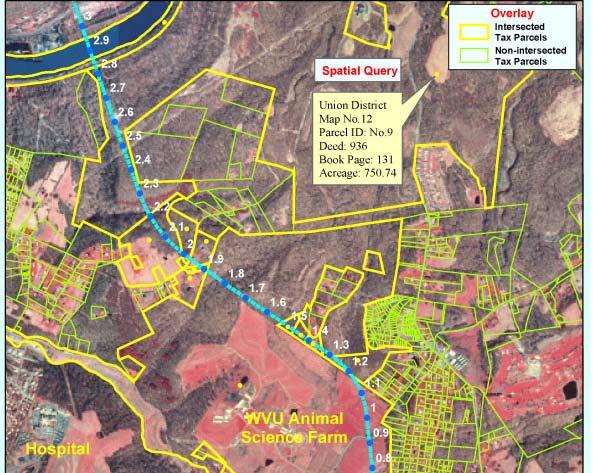
17 Linked to Assessment Database A GIS links locational (spatial) and database (tabular) information + Tax Parcel Record: Anytown, West Virginia Parcel Number: 1 Owner: Mr. John Sebastian Doe Address: 3057 Apis Mellifera Road Address: Anytown, WV Phone: Acreage: 116 Appraised Value: 220,000 Mineral Rights: No Zoning Classification Single Family Residential (R1) Tax District: Trap Hill District District Number: 12 Map Number: 21 Spatial Information Tabular Information Database links to parcels via: (1) parcel identifier or (2) standardized address


18 GIS = Parcel Features + Database GIS are a combination of geographic data and attribute data Parcel polygons are the spatial features CAMA records are the attributes GIS allow two key types of functionality Point at a graphic feature and retrieve attributes Query attributes and see graphic result of query on a map


19 Topology (spatial relationships) How to model spatial relationships Parcels cannot overlap one another Building footprints must not overlap parcels Parcel lines cannot have dangles Error / Validation Checks

20 Topology Define Relationships Define Spatial Relationships
21 Parcel Data Model: table Land Base Data Sets Entity Related to Spatial Type Parcel Boundary Parcel ID (CAMA) Area or line Parcel ID Parcel Boundary Text Lot Numbers Text Interior lot / tract lines Parcel Boundary Line Ownership Parcel ID (CAMA) Table Landhook Text or line Dimensions (acreage) Parcel ID (CAMA) Text Dimensions (metes and bounds) Text Parcel Photograph Parcel ID Image Structures Parcel Boundary Area or point Address Parcel ID (CAMA) / Structure Address Location Parcel Index Grid Area or Line District Boundaries Parcel Boundary Area Corporation Boundaries Parcel Boundary Area Reference Data Sets Roads Area or line Water Bodies Area or line Political Boundaries Area or line Aerial Photos Image Satellite Images Image Topographic Maps Image Geographic Names Referenced features Text Flood hazards Area or line Right of Way Dimensions Referenced features Text

22 Parcel Data Model: diagram

23 Seamless Seamless Not Seamless

24 Seamless - countywide Seamless between rural districts and corporations
25 Digital Reference A digital landbase is a digitized reference to the legal cadastre, specifically, a reference to the source documents that describe the intent of the on-ground cadastre A digital landbase is not the official cadastre of record only a reference to it. A digital landbase does not define land tenure boundaries. Example: Assessor's Parcel Map used for taxation. These maps should not be used as the basis for engineering and construction which determines the location of built features ("fixed works")

26 GIS Tax Map Conversion Steps Approaches for parcel data automation Automation of hard copy $2 - $6+ /parcel Conversion of CAD data $2 - $6+ /parcel Parcel deed research (COGO) $15 - $20/parcel Hybrid Approach Use GIS to identify problematic parcels that might require deed research Polygons with no matching CAMA records CAMA records with no matching polygons Wide variance between measured area and CAMA area Splits required after digital conversion Perhaps: 70%-80% of $2 - $6/parcel 20%-30% of $15 - $20 Source: Applied Geographics, Inc.


27 Digital Conversion - Geology Hand drawn geologic features on USGS 1:24,000-scale topographic map Geologic map digital conversion
 Index grid Make adjustments to enhance fit to base map Performed during automation Or later, as a separate")
28 Conversion of Hardcopy Maps Scan existing maps Georeference scans to a base map Control points: street intersections, bldg. corners Heads-up digitize linework Parcels ROW/easement Dimension annotation (extra $) Index grid Make adjustments to enhance fit to base map Performed during automation Or later, as a separate project Create topology Label parcels with their ID number (e.g. Map and Lot) Link to to CAMA database Obtain dump from CAMA in DBF, MDB or ASCII Database table join using ID number as primary key Produce checkplots Integrate parcel related features with other reference base layers Create electronic map book of pretty maps. Source: Applied Geographics, Inc.

29 Select Base Layers A base map is needed to establish a coordinate system, accuracy and ability to overlay with other layers TOPOGRAPHIC MAPS Scale: 1:24,000 1 = 2,000 ft. Date: avg. map 23 yrs. old CIR AERIAL PHOTOS Scale: 1:12,000 1 = 1,000 ft. Date: AERIAL PHOTOS Scale: 1: = 400 ft. Date: Spring 2003


30 Heads-Up Digitizing / Data Integration Parcel Related Features Geo-Referenced Tax Map Digitized Parcel Lines Parcel IDs Interior Lot Lines and IDs Land Hooks and Buildings Parcel Dimensions Reference Datasets Road and Water Layers Arial Photography Integration (spatial compatibility) of data layers is more difficult if compiled from different sources or assembled at varying time intervals
31 Parcel Line Work Adjustments Can be a highly interpretive and subjective process Try to make parcels and reference layers look logically consistent If the fit between parcels and base map is really bad, a need for deed research may be implied

32 CAMA Reconciliation Process Process to determine how well CAMA matches polygons 99% match rates are possible Known problems with exempt properties Combined lots can pose issues Two parcels, one CAMA record Condos pose an issue Most issues are resolved during the checkplot review process Source: Applied Geographics, Inc. Parcels with FAILED PID link
33 Map Tile Reference System Must covert grid system to a GIS format Primary map tiles Nested Grid True Grid Modified Grid Random Orientation true north Y Y Y N Uniform tile size Y Y N N 100 scale nested within 400 scale Y N N N Map Tile Reference System: The parcel reference system for each county is subdivided into rural tax districts and corporations, which are further subdivided into map tiles / map sheets. The type of parcel reference system is determined by the primary map scale (usually 1 =400 scale) configuration for rural maps and its relationship to urban areas (usually 1 =100 scale).
34 Random Grid Pendleton County Random Orientation, No uniform tile size, No nesting of 100 and 400 scale maps
35 Modified Grid - Wetzel County True North Orientation, No uniform tile size, No nesting of 100 and 400 scale maps


36 Electronic Map Books using indexes

37 Map Products Pretty Maps Visually appealing cartographic product Print-ready electronic versions

38 Internet Applications

39 Maintenance Plan maintenance strategy before digital conversion Can be done in-house, or out-sourced Diligence and Staff Responsibility required It s more fun to make maps than update data Adjust business process workflow Update data instead of maps Can be done continually, not just annually Coordinate with Planning/Building Departments New sub-divisions Base map changes (new buildings, etc.) Source: Applied Geographics, Inc.


40 Challenges digital conversion Maintaining two systems (manual and digital) Expense Time Technical Issues Organizational Issues - Sharing resources and expenses with other entities can minimize redundancy, ensure interoperability, and maximize benefits. - Conduct pilots to resolve critical issues.

41 WV Digital Tax Mapping Status

42 Components of a Tax GIS A working GIS integrates these key components: hardware software data people methods


43 Hardware The hardware is the computer and peripherals on which the GIS operates Traditional Mapping MAP TYPEWRITER MANUAL DRAFTING TOOLS Computer Mapping COMPUTER PLOTTER GPS CD-ROM
44 Software GIS software provides the functions and tools users need to store analyze, and display geographical information. It includes the assessment database software. Multiple software vendors Family or suite of software products necessary to have complete GIS functionality (i.e., ESRI: ArcView, ArcEditor, ArcInfo) Adequate training and technical support
, each of which represents a")
 Digital Topographic Map Digital Ortho Quarter Quad Aerial Photography Vector A graphic data structure that represents")
45 Data Raster An important component of GIS is complete, current, and accurate data. Image A form of GIS data structure that quantizes space into an array or grid of uniformly shaped cells (pixels), each of which represents a limited, but defined, amount of the earth s surface. Digital Raster Graphic (DRG) Digital Topographic Map Digital Ortho Quarter Quad Aerial Photography Vector A graphic data structure that represents the points, lines, and areas of geographical space by exact X and Y coordinates. Digital Line Graph (DLG) Hydrographic features County boundaries with linked data


46 WV Spatial Data Infrastructure Access to $50 million dollars worth of spatial data Armories Railroads Pipelines Sewer Treatment Plants Rural Tax Districts Police Towers

47 WV Addressing & Mapping Layers ($15 million value)

48 Digital Flood Layers

49 Mineral Parcel Mapping Project - WVDTR

50 Mineral Parcel Mapping Project Can be a starting point for digital tax map conversions Not all surface parcel related features collected Not continually updated Local Tax Map WV DTR Collection State Mapping Project
51 People GIS technology is clearly of limited value without people to manage the system and to develop plans for applying it. County Level Political Champion (i.e., Assessor, County Commissioners) Tax Mapper (technically proficient) State Level Political Champion (State Tax Office, Tax Commission) Application Experts (Standards, Training, Education) Private Sector Reputable Vendors Specialize in tax map applications and customization Training and technical support People
52 Methods Methods, plans, specifications, standards, and business rules describing how technology is applied Plans (integrate with other state IT plans) Digital Tax Map Plan (proposed). What is the vision? Interrelate with other state plans The National Map State Business Plan (2003) WVGISTC Strategic Plan (2003) Addressing and Management Maintenance Plan (in progress) All Hazard Mitigation Plan (in progress) Flood Map Modernization State Business Plan (proposed) State GIS Plan (in progress) State IT plans Vision Procedures (for digital tax maps) Statewide Procedures for the Manual Maintenance of Surface Tax Maps, Title-Series Tax Map Sales Title-Series
53 Methods (cont.) New business rules are needed for compiling and sharing GIS tax data with other government agencies. GIS TAX Database Other State Databases Server Statewide Configuration Concept Govt. Agencies Needing Access Office of Emergency Services Development Office Redistricting Office Division of Highways
54 Future Directions Digital Tax Guidelines (Report) Elaborate on information in this presentation Definitions, Procedures, Policies, Organization Roles, Benefits Preston County as pilot Organizational Roles Property Valuation Commission (PVC) Overarching body (authority) Approve digital tax guidelines Update existing regulations to include digital mapping procedures Establish new business rules / organizational role Tax Advisory Committee Develop digital tax guidelines Interface with other strategic plans Present and obtain feedback from tax geospatial community Consult with private sector Proposed Members (WVU GIS Technical Center, Tax and Revenue, WV GIS Coordinator, 3 Assessors)
55 WVGISTC s Role? Assist with Digital Tax Guidelines Report Standards Specifications Procedures Assist with editing of tax map regulations Authority Policies Training and Outreach Applied Research Repository of digital tax files for state government Kurt Donaldson Project Manager WV GIS Technical Center kdonalds@wvu.edu (304) x 4336
Techniques for Science Teachers: Using GIS in Science Classrooms.
 Techniques for Science Teachers: Using GIS in Science Classrooms. After ESRI, 2008 GIS A Geographic Information System A collection of computer hardware, software, and geographic data used together for
GIS = Geographic Information Systems;
 What is GIS GIS = Geographic Information Systems; What Information are we talking about? Information about anything that has a place (e.g. locations of features, address of people) on Earth s surface,
NR402 GIS Applications in Natural Resources
 NR402 GIS Applications in Natural Resources Lesson 1 Introduction to GIS Eva Strand, University of Idaho Map of the Pacific Northwest from http://www.or.blm.gov/gis/ Welcome to NR402 GIS Applications in
DATA SOURCES AND INPUT IN GIS. By Prof. A. Balasubramanian Centre for Advanced Studies in Earth Science, University of Mysore, Mysore
 DATA SOURCES AND INPUT IN GIS By Prof. A. Balasubramanian Centre for Advanced Studies in Earth Science, University of Mysore, Mysore 1 1. GIS stands for 'Geographic Information System'. It is a computer-based
Introduction to GIS I
 Introduction to GIS Introduction How to answer geographical questions such as follows: What is the population of a particular city? What are the characteristics of the soils in a particular land parcel?
CENSUS MAPPING WITH GIS IN NAMIBIA. BY Mrs. Ottilie Mwazi Central Bureau of Statistics Tel: October 2007
 CENSUS MAPPING WITH GIS IN NAMIBIA BY Mrs. Ottilie Mwazi Central Bureau of Statistics E-mail: omwazi@npc.gov.na Tel: + 264 61 283 4060 October 2007 Content of Presentation HISTORICAL BACKGROUND OF CENSUS
for Effective Land Administration
 Role of Geospatial Technology in Land Information System(LIS) for Effective Land Administration Dr. Deb Jyoti Pal Sections Role of GIS in Land Records Proposed Work Flow Case Studies Role of GIS Creating
Introduction-Overview. Why use a GIS? What can a GIS do? Spatial (coordinate) data model Relational (tabular) data model
 data model Relational (tabular) data model") Introduction-Overview Why use a GIS? What can a GIS do? How does a GIS work? GIS definitions Spatial (coordinate) data model Relational (tabular) data model intro_gis.ppt 1 Why use a GIS? An extension
Introduction-Overview Why use a GIS? What can a GIS do? How does a GIS work? GIS definitions Spatial (coordinate) data model Relational (tabular) data model intro_gis.ppt 1 Why use a GIS? An extension
GIS (GEOGRAPHIC INFORMATION SYSTEMS)
") GIS (GEOGRAPHIC INFORMATION SYSTEMS) 1 1. DEFINITION SYSTEM Any organised assembly of resources and procedures united and regulated by interaction or interdependence to complete a set of specific functions.
GIS (GEOGRAPHIC INFORMATION SYSTEMS) 1 1. DEFINITION SYSTEM Any organised assembly of resources and procedures united and regulated by interaction or interdependence to complete a set of specific functions.
Enhancing Parcel Data In Colleton County. February 10, 2009
 Enhancing Parcel Data In Colleton County GIS & CAMA Conference February 10, 2009 Introductions Bruce T. Harper Technology Director Colleton County, SC Bill Wetzel National GIS Account Manager The Sidwell
John Laznik 273 Delaplane Ave Newark, DE (302)
") Office Address: John Laznik 273 Delaplane Ave Newark, DE 19711 (302) 831-0479 Center for Applied Demography and Survey Research College of Human Services, Education and Public Policy University of Delaware
Office Address: John Laznik 273 Delaplane Ave Newark, DE 19711 (302) 831-0479 Center for Applied Demography and Survey Research College of Human Services, Education and Public Policy University of Delaware
GIS ADMINISTRATOR / WEB DEVELOPER EVANSVILLE-VANDERBURGH COUNTY AREA PLAN COMMISSION
 GIS ADMINISTRATOR / WEB DEVELOPER EVANSVILLE-VANDERBURGH COUNTY AREA PLAN COMMISSION SALARY RANGE INITIATION $43,277 SIX MONTHS $45,367 POSITION GRADE PAT VI The Evansville-Vanderburgh County Area Plan
Comptroller GIS and Property Data. Ken Morrell Assessment Systems Manager Division of Property Assessments February 22, 2007
 Comptroller GIS and Property Data Ken Morrell Assessment Systems Manager Division of Property Assessments February 22, 2007 Comptroller Divisions Using and Supporting GIS Office of Local Government Implement
Managing Parcels in ArcGIS 10
 Managing Parcels in ArcGIS 10 ArcGIS Geodatabase Editing Workflows Editing Maps Tim Hensley Esri Solution Engineer Karen Lowrey Esri Geospatial Analyst Basemaps Public Access Value Analysis ArcGIS 10 Parcel
 Boone County GIS has the right to inquire about and investigate the use of any requested products and deny access to anyone based on concerns relating to privacy, security, public health, public safety,
Information. Information Technology. Geographic. Services (GIS) 119 W Indiana Ave Deland, FL 32720
 119 W Indiana Ave Deland, FL 32720") Information Technology Geographic Information Services (GIS) 119 W Indiana Ave Deland, FL 32720 A GIS consists of 5 primary components: Hardware Software People Data Methods or Business Processes --- Hardware
Information Technology Geographic Information Services (GIS) 119 W Indiana Ave Deland, FL 32720 A GIS consists of 5 primary components: Hardware Software People Data Methods or Business Processes --- Hardware
Syllabus Reminders. Geographic Information Systems. Components of GIS. Lecture 1 Outline. Lecture 1 Introduction to Geographic Information Systems
 Syllabus Reminders Geographic Information s Lecture Introduction to Geographic Information s. Class Info: www.saigis.com/class/ 2. Office T / TH (8:00-9:30 a.m.) and (2:30 3:30pm) or Appt 3. Email: burgerpr@unk.edu
SRJC Applied Technology 54A Introduction to GIS
 SRJC Applied Technology 54A Introduction to GIS Overview Lecture of Geographic Information Systems Fall 2004 Santa Rosa Junior College Presented By: Tim Pudoff, GIS Coordinator, County of Sonoma, Information
GIS Geographical Information Systems. GIS Management
 GIS Geographical Information Systems GIS Management Difficulties on establishing a GIS Funding GIS Determining Project Standards Data Gathering Map Development Recruiting GIS Professionals Educating Staff
GIS for the Beginner on a Budget
 GIS for the Beginner on a Budget Andre C. Bally, RLA, GIS Coordinator, Harris County Public Infrastructure Department Engineering Division This presentation, GIS for Beginners on a Budget. will briefly
WV County GIS Plan Template
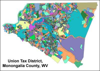
 Monongalia County GIS Strategic Plan and WV County GIS Plan Template Draft Report July 2004 Prepared by: Kurt Donaldson WV GIS Technical Center Department of Geology and Geography West Virginia University
COURSE INTRODUCTION & COURSE OVERVIEW
 week 1 COURSE INTRODUCTION & COURSE OVERVIEW topics of the week Instructor introduction Students introductions Course logistics Course objectives Definition of GIS The story of GIS introductions Who am
An Introduction to Geographic Information System
 An Introduction to Geographic Information System PROF. Dr. Yuji MURAYAMA Khun Kyaw Aung Hein 1 July 21,2010 GIS: A Formal Definition A system for capturing, storing, checking, Integrating, manipulating,
KING GEORGE COUNTY DEPARTMENT OF COMMUNITY DEVELOPMENT
 GIS REPORT 2016 KING GEORGE COUNTY DEPARTMENT OF COMMUNITY DEVELOPMENT Background The GIS (Geographic Information System) coordinator was hired in 2001 to develop a GIS for King George County. Prior to
McHenry County Property Search Sources of Information
 Disclaimer: The information in this system may contain inaccuracies or typographical errors. The information in this system is a digital representation of information derived from original documents; as
Statewide Topographic Mapping Program
 Statewide Topographic Mapping Program February 28, 2018 www.dotd.la.gov Outline Purpose of the Statewide Topographic Mapping Program History Breakdown of R.S. 48:36 - Topographic Mapping Statewide Topographic
Applications of Map Book Software for Local Government Agencies. Melisa Bowman Lincoln Parish GIS
 Applications of Map Book Software for Local Government Agencies Melisa Bowman Lincoln Parish GIS North Central Louisiana Parish 472 Square Miles Population: 42,000 Ruston: Largest Municipality Home to
Welcome to NR502 GIS Applications in Natural Resources. You can take this course for 1 or 2 credits. There is also an option for 3 credits.
 Welcome to NR502 GIS Applications in Natural Resources. You can take this course for 1 or 2 credits. There is also an option for 3 credits. The 1st credit consists of a series of readings, demonstration,
INTRODUCTION TO GEOGRAPHIC INFORMATION SYSTEM By Reshma H. Patil
 INTRODUCTION TO GEOGRAPHIC INFORMATION SYSTEM By Reshma H. Patil ABSTRACT:- The geographical information system (GIS) is Computer system for capturing, storing, querying analyzing, and displaying geospatial
Louisiana Transportation Engineering Conference. Monday, February 12, 2007
 Louisiana Transportation Engineering Conference Monday, February 12, 2007 Agenda Project Background Goal of EIS Why Use GIS? What is GIS? How used on this Project Other site selection tools I-69 Corridor
FIRE DEPARMENT SANTA CLARA COUNTY
 DEFINITION FIRE DEPARMENT SANTA CLARA COUNTY GEOGRAPHIC INFORMATION SYSTEM (GIS) ANALYST Under the direction of the Information Technology Officer, the GIS Analyst provides geo-spatial strategic planning,
Bentley Map Advancing GIS for the World s Infrastructure
 Bentley Map Advancing GIS for the World s Infrastructure Presentation Overview Why would you need Bentley Map? What is Bentley Map? Where is Bentley Map Used? Why would you need Bentley Map? Because your
Display data in a map-like format so that geographic patterns and interrelationships are visible
 Vilmaliz Rodríguez Guzmán M.S. Student, Department of Geology University of Puerto Rico at Mayagüez Remote Sensing and Geographic Information Systems (GIS) Reference: James B. Campbell. Introduction to
Introduction to GIS. Dr. M.S. Ganesh Prasad
 Introduction to GIS Dr. M.S. Ganesh Prasad Department of Civil Engineering The National Institute of Engineering, MYSORE ganeshprasad.nie@gmail.com 9449153758 Geographic Information System (GIS) Information
FUNDAMENTALS OF GEOINFORMATICS PART-II (CLASS: FYBSc SEM- II)
") FUNDAMENTALS OF GEOINFORMATICS PART-II (CLASS: FYBSc SEM- II) UNIT:-I: INTRODUCTION TO GIS 1.1.Definition, Potential of GIS, Concept of Space and Time 1.2.Components of GIS, Evolution/Origin and Objectives
FUNDAMENTALS OF GEOINFORMATICS PART-II (CLASS: FYBSc SEM- II) UNIT:-I: INTRODUCTION TO GIS 1.1.Definition, Potential of GIS, Concept of Space and Time 1.2.Components of GIS, Evolution/Origin and Objectives
SoilView: Development of a Custom GIS Application for Publishing Soil Surveys
 SoilView: Development of a Custom GIS Application for Publishing Soil Surveys Allan Johnson and Mike Wigginton Abstract Currently, digital soils information can be obtained from many sources. Numerous
GEOMATICS. Shaping our world. A company of
 GEOMATICS Shaping our world A company of OUR EXPERTISE Geomatics Geomatics plays a mayor role in hydropower, land and water resources, urban development, transport & mobility, renewable energy, and infrastructure
Developing a Subdivision Build- Out Study and Site Suitability Tool; Enabling Access Through a Web GIS Application
 Developing a Subdivision Build- Out Study and Site Suitability Tool; Enabling Access Through a Web GIS Application DOUG SEXTON GEOG 596A SUMMER 2017 ADVISOR: DR. JAMES O BRIEN Project Outline Introduction
Land-Line Technical information leaflet
 Land-Line Technical information leaflet The product Land-Line is comprehensive and accurate large-scale digital mapping available for Great Britain. It comprises nearly 229 000 separate map tiles of data
JOB TITLE: CURRENT CLASSIFICATION/GRID POSITION # GIS Coordinator AD Grid Level 6(c) # 420
 # 420") COUNTY OF GRANDE PRAIRIE JOB DESCRIPTION JOB TITLE: CURRENT CLASSIFICATION/GRID POSITION # GIS Coordinator AD Grid Level 6(c) # 420 NOC CODE: 2255 STANDARD HOURS: 35 hours/week (non-management) JOB TITLE
COUNTY OF GRANDE PRAIRIE JOB DESCRIPTION JOB TITLE: CURRENT CLASSIFICATION/GRID POSITION # GIS Coordinator AD Grid Level 6(c) # 420 NOC CODE: 2255 STANDARD HOURS: 35 hours/week (non-management) JOB TITLE
An Internet-based Agricultural Land Use Trends Visualization System (AgLuT)
") An Internet-based Agricultural Land Use Trends Visualization System (AgLuT) Prepared for Missouri Department of Natural Resources Missouri Department of Conservation 07-01-2000-12-31-2001 Submitted by
An Internet-based Agricultural Land Use Trends Visualization System (AgLuT) Prepared for Missouri Department of Natural Resources Missouri Department of Conservation 07-01-2000-12-31-2001 Submitted by
McHenry County Property Search Sources of Information
 Disclaimer: The information in this system may contain inaccuracies or typographical errors. The information in this system is a digital representation of information derived from original documents; as
PC ARC/INFO and Data Automation Kit GIS Tools for Your PC
 ESRI PC ARC/INFO and Data Automation Kit GIS Tools for Your PC PC ARC/INFO High-quality digitizing and data entry Powerful topology building Cartographic design and query Spatial database query and analysis
IMPERIAL COUNTY PLANNING AND DEVELOPMENT
 IMPERIAL COUNTY PLANNING AND DEVELOPMENT GEODATABASE USER MANUAL FOR COUNTY BUSINESS DEVELOPMENT GIS June 2010 Prepared for: Prepared by: County of Imperial Planning and Development 801 Main Street El
Designing GIS Databases to Support Mapping and Map Production Charlie Frye, ESRI Redlands Aileen Buckley, ESRI Redlands
 Designing GIS Databases to Support Mapping and Map Production Charlie Frye, ESRI Redlands Aileen Buckley, ESRI Redlands 1 Designing GIS Databases to Support Mapping and Map Production Charlie Frye, ESRI
Geographic Information Systems. Introduction to Data and Data Sources
 Geographic Information Systems Introduction to Data and Data Sources Presented by John Showler, NJDA-SSCC NJ SCD GIS Training Session December 10, 209 The Objectives of this session are 3-fold: 1. Introduce
Abstract. Keywords: Geographic information systems and digital data model. 1. Introduction
 Abstract GISMO - A Geographical Information System for a Municipality Office Ramzi A. Haraty and Youssef O. Kaddoura Lebanese American University P.O. Box 13-5053 Chouran Beirut, Lebanon 1102 2801 Email:
WELCOME & INTRODUCTIONS
 GIS Monroe Geographic Information System January 31, 2018 WELCOME & INTRODUCTIONS Chip Thomas, Ritter GIS Sarah Schrader, Acct. Mgr., ESRI Chris Beyett, Solutions Engineer, ESRI Colleen Hinzmann, IT Director,
Course overview. Grading and Evaluation. Final project. Where and When? Welcome to REM402 Applied Spatial Analysis in Natural Resources.
 Welcome to REM402 Applied Spatial Analysis in Natural Resources Eva Strand, University of Idaho Map of the Pacific Northwest from http://www.or.blm.gov/gis/ Where and When? Lectures Monday & Wednesday
Canadian Board of Examiners for Professional Surveyors Core Syllabus Item C 5: GEOSPATIAL INFORMATION SYSTEMS
 Study Guide: Canadian Board of Examiners for Professional Surveyors Core Syllabus Item C 5: GEOSPATIAL INFORMATION SYSTEMS This guide presents some study questions with specific referral to the essential
Write a report (6-7 pages, double space) on some examples of Internet Applications. You can choose only ONE of the following application areas:
 on some examples of Internet Applications. You can choose only ONE of the following application areas:") UPR 6905 Internet GIS Homework 1 Yong Hong Guo September 9, 2008 Write a report (6-7 pages, double space) on some examples of Internet Applications. You can choose only ONE of the following application
UPR 6905 Internet GIS Homework 1 Yong Hong Guo September 9, 2008 Write a report (6-7 pages, double space) on some examples of Internet Applications. You can choose only ONE of the following application
Land Administration and Cadastre
 Geomatics play a major role in hydropower, land and water resources and other infrastructure projects. Lahmeyer International s (LI) worldwide projects require a wide range of approaches to the integration
Digital Tax Maps Westport Island Project Summary
 Digital Tax Maps Westport Island Project Summary Presented to the: Mid-Coast Regional Planning Commission Creating GIS-Based Digital Tax Maps And Linked Assessment Records For Small Towns on a Budget Dennis
Steve Pietersen Office Telephone No
 Steve Pietersen Steve.Pieterson@durban.gov.za Office Telephone No. 031 311 8655 Overview Why geography matters The power of GIS EWS GIS water stats EWS GIS sanitation stats How to build a GIS system EWS
GIS-T 2010 Building a Successful Geospatial Data Sharing Framework: A Ohio DOT Success Story
 GIS-T 2010 Building a Successful Geospatial Data Sharing Framework: A Ohio DOT Success Story ODOT District 2 GIS John Puente District 1 GIS Coordinator\ Planning Administrator 2 Interoperability 3 District
CHAPTER 22 GEOGRAPHIC INFORMATION SYSTEMS
 CHAPTER 22 GEOGRAPHIC INFORMATION SYSTEMS PURPOSE: This chapter establishes the administration and use of to improve the quality and accessibility of Department s spatial information and support graphical
A Basic Introduction to Geographic Information Systems (GIS) ~~~~~~~~~~
 ~~~~~~~~~~") A Basic Introduction to Geographic Information Systems (GIS) ~~~~~~~~~~ Rev. Ronald J. Wasowski, C.S.C. Associate Professor of Environmental Science University of Portland Portland, Oregon 3 September
A Basic Introduction to Geographic Information Systems (GIS) ~~~~~~~~~~ Rev. Ronald J. Wasowski, C.S.C. Associate Professor of Environmental Science University of Portland Portland, Oregon 3 September
E Geographic Information System. Created By: Freda Rocker Pearl River County Mapping
 E-9-1-1 Geographic Information System Created By: Freda Rocker Pearl River County Mapping frocker@pearlrivercounty.net Overview of Pearl River County E-9-1-1 Communications District GIS In 1998 the Pearl
Chapter 5. GIS The Global Information System
 Chapter 5 GIS The Global Information System What is GIS? We have just discussed GPS a simple three letter acronym for a fairly sophisticated technique to locate a persons or objects position on the Earth
SOLUTIONS ADVANCED GIS. TekMindz are developing innovative solutions that integrate geographic information with niche business applications.
 ADVANCED GIS SOLUTIONS TekMindz are developing innovative solutions that integrate geographic information with niche business applications. TEK INDZ TM GIS Services Overview At the leading edge of geospatial
4. GIS Implementation of the TxDOT Hydrology Extensions
 4. GIS Implementation of the TxDOT Hydrology Extensions A Geographic Information System (GIS) is a computer-assisted system for the capture, storage, retrieval, analysis and display of spatial data. It
Using MAGIC to Access Spatial Imagery: Putting ER Mapper Image Web Server, ArcIMS and MrSID to work in your Library
 Using MAGIC to Access Spatial Imagery: Putting ER Mapper Image Web Server, ArcIMS and MrSID to work in your Library Patrick McGlamery Shirley Quintero University of Connecticut Libraries Building the Connecticut
Geographic Information Systems (GIS) in Environmental Studies ENVS Winter 2003 Session III
 in Environmental Studies ENVS Winter 2003 Session III") Geographic Information Systems (GIS) in Environmental Studies ENVS 6189 3.0 Winter 2003 Session III John Sorrell York University sorrell@yorku.ca Session Purpose: To discuss the various concepts of space,
Geographic Information Systems (GIS) in Environmental Studies ENVS 6189 3.0 Winter 2003 Session III John Sorrell York University sorrell@yorku.ca Session Purpose: To discuss the various concepts of space,
BROADBAND DEMAND AGGREGATION: PLANNING BROADBAND IN RURAL NORTHERN CALIFORNIA
 BROADBAND DEMAND AGGREGATION: PLANNING BROADBAND IN RURAL NORTHERN CALIFORNIA Steven J. Steinberg, Ph.D a,b, *, Rebecca Degagne a, M.S., Michael Gough a a Institute for Spatial Analysis, Humboldt State
Outline. Chapter 1. A history of products. What is ArcGIS? What is GIS? Some GIS applications Introducing the ArcGIS products How does GIS work?
 Outline Chapter 1 Introducing ArcGIS What is GIS? Some GIS applications Introducing the ArcGIS products How does GIS work? Basic data formats The ArcCatalog interface 1-1 1-2 A history of products Arc/Info
GIS Workshop Data Collection Techniques
 GIS Workshop Data Collection Techniques NOFNEC Conference 2016 Presented by: Matawa First Nations Management Jennifer Duncan and Charlene Wagenaar, Geomatics Technicians, Four Rivers Department QA #: FRG
GIS Monroe Geographic Information System March 14, 2018
 GIS Monroe Geographic Information System March 14, 2018 Goals Maintain Enterprise/County-wide geo-database Increase spatial accuracy of data Build and acquire more data layers Increase use of GIS; as another
Strategic Plan. January Prepared by the WV State GIS Technical Center
 Strategic Plan January 2004 Prepared by the WV State GIS Technical Center West Virginia GIS Technical Center 425 White Hall Department of Geology and Geography PO Box 6300 West Virginia University Morgantown
GEOGRAPHIC INFORMATION SYSTEMS
 GEOGRAPHIC INFORMATION SYSTEMS 4-H Round-Up Community Transitions Workshop Daniel Hanselka June 14, 2011 Goals of the Workshop Answer the question: What is GIS? Uses of GIS. Some of the Common Terminology
CHILEAN GEO-SPATIAL NATIONAL DATA INFRASTRUCTURE (INDE) Pablo Gran Rodrigo Barriga Alfredo Gonzalez María L. Advis Juan C. Montero Leonardo Oyarzun
 Pablo Gran Rodrigo Barriga Alfredo Gonzalez María L. Advis Juan C. Montero Leonardo Oyarzun") CHILEAN GEO-SPATIAL NATIONAL INFRASTRUCTURE (INDE) Pablo Gran Rodrigo Barriga Alfredo Gonzalez María L. Advis Juan C. Montero Leonardo Oyarzun ABSTRACT The present paper summarizes a joint effort undertaken
CHILEAN GEO-SPATIAL NATIONAL INFRASTRUCTURE (INDE) Pablo Gran Rodrigo Barriga Alfredo Gonzalez María L. Advis Juan C. Montero Leonardo Oyarzun ABSTRACT The present paper summarizes a joint effort undertaken
Production Line Tool Sets
 Production Line Tool Sets Tools for high-quality database production and cartographic output Production Line Tool Sets Production Line Tool Sets (PLTS) by ESRI are a collection of software applications
Understanding Geographic Information System GIS
 Understanding Geographic Information System GIS What do we know about GIS? G eographic I nformation Maps Data S ystem Computerized What do we know about maps? Types of Maps (Familiar Examples) Street Maps
GIS Data Conversion: Strategies, Techniques, and Management
 GIS Data Conversion: Strategies, Techniques, and Management Pat Hohl, Editor SUB G6ttlngen 208 494219 98 A11838 ONWORD P R E S S V Contents SECTION 1: Introduction 1 Introduction and Overview 3 Ensuring
New Land Cover & Land Use Data for the Chesapeake Bay Watershed
 New Land Cover & Land Use Data for the Chesapeake Bay Watershed Why? The Chesapeake Bay Program (CBP) partnership is in the process of improving and refining the Phase 6 suite of models used to inform
Geometric Algorithms in GIS
 Geometric Algorithms in GIS GIS Visualization Software Dr. M. Gavrilova GIS Software for Visualization ArcView GEO/SQL Digital Atmosphere AutoDesk Visual_Data GeoMedia GeoExpress CAVE? Visualization in
Introduction to GIS. Geol 4048 Geological Applications of Remote Sensing
 Introduction to GIS Geol 4048 Geological Applications of Remote Sensing GIS History: Before Computers GIS History Using maps for a long time Dr. Roger F. Tomlinson Father of GIS He was an English geographer
M.Y. Pior Faculty of Real Estate Science, University of Meikai, JAPAN
 GEOGRAPHIC INFORMATION SYSTEM M.Y. Pior Faculty of Real Estate Science, University of Meikai, JAPAN Keywords: GIS, rasterbased model, vectorbased model, layer, attribute, topology, spatial analysis. Contents
How GIS can be used for improvement of literacy and CE programmes
 How GIS can be used for improvement of literacy and CE programmes Training Workshop for Myanmar Literacy Resource Center (MLRC) ( Yangon, Myanmar, 11 20 October 2000 ) Presented by U THEIN HTUT GEOCOMP
Regional GIS Initiatives Geospatial Technology Center
 Regional GIS Initiatives Geospatial Technology Center Mr. Bobby Lear GIS Coordinator St. James Parish & Dr. Balaji Ramachandran Contractors Educational Trust Fund Endowed Professor Geomatics Program, Department
Data Aggregation with InfraWorks and ArcGIS for Visualization, Analysis, and Planning
 Data Aggregation with InfraWorks and ArcGIS for Visualization, Analysis, and Planning Stephen Brockwell President, Brockwell IT Consulting, Inc. Join the conversation #AU2017 KEYWORD Class Summary Silos
Exploring the boundaries of your built and natural world. Geomatics
 Exploring the boundaries of your built and natural world Geomatics Before the Luxor brought magic to the Las Vegas strip and before the South LRT extension in Edmonton gave residents a new route to travel,
Cadcorp Introductory Paper I
 Cadcorp Introductory Paper I An introduction to Geographic Information and Geographic Information Systems Keywords: computer, data, digital, geographic information systems (GIS), geographic information
Providing Public Access to King County GIS Data. Presented by: Michael Jenkins King County GIS Center Seattle, WA
 Providing Public Access to King County GIS Data Presented by: Michael Jenkins King County GIS Center Seattle, WA King County, Washington Microsoft Boeing Amazon.Com Starbucks Port of Seattle Weyerhauser
CHAPTER 7 PRODUCT USE AND AVAILABILITY
 CHAPTER 7 PRODUCT USE AND AVAILABILITY Julie Prior-Magee Photo from SWReGAP Training Site Image Library Recommended Citation Prior-Magee, J.S. 2007. Product use and availability. Chapter 7 in J.S. Prior-Magee,
IC ARTICLE LAND SURVEYORS
 IC 25-21.5 ARTICLE 21.5. LAND SURVEYORS IC 25-21.5-1 Chapter 1. Definitions IC 25-21.5-1-1 Application of chapter Sec. 1. The definitions in this chapter apply throughout this article. As added by P.L.23-1991,
Applications: Introduction Task 1: Introduction to ArcCatalog Task 2: Introduction to ArcMap Challenge Question References
 CHAPTER 1 INTRODUCTION 1.1 GIS? 1.1.1 Components of a GIS 1.1.2 A Brief History of GIS 1.1.3 GIS Software Products Box 1.1 A List of GIS Software Producers and Their Main Products 1.2 GIS Applications
Desktop GIS for Geotechnical Engineering
 Desktop GIS for Geotechnical Engineering Satya Priya Deputy General Manager (Software) RMSI, A-7, Sector 16 NOIDA 201 301, UP, INDIA Tel: +91-120-2511102 Fax: +91-120-2510963 Email: Satya.Priya@rmsi.com
USING GIS CARTOGRAPHIC MODELING TO ANALYSIS SPATIAL DISTRIBUTION OF LANDSLIDE SENSITIVE AREAS IN YANGMINGSHAN NATIONAL PARK, TAIWAN
 CO-145 USING GIS CARTOGRAPHIC MODELING TO ANALYSIS SPATIAL DISTRIBUTION OF LANDSLIDE SENSITIVE AREAS IN YANGMINGSHAN NATIONAL PARK, TAIWAN DING Y.C. Chinese Culture University., TAIPEI, TAIWAN, PROVINCE
MODERNIZATION OF THE MUNICIPAL MAPPING USING HIGH END GNSS SYSTEM AND GIS SOFTWARE
 MODERNIZATION OF THE MUNICIPAL MAPPING USING HIGH END GNSS SYSTEM AND GIS SOFTWARE Mr. R. A. R. Khan Assistant Engineer, Sewerage Utility Management Centre (SUMC) Municipal Corporation Of Greater Mumbai
Advanced Algorithms for Geographic Information Systems CPSC 695
 Advanced Algorithms for Geographic Information Systems CPSC 695 Think about Geography What is Geography The 3 W s of Geography What is where Why is it there Why do I care Data - Data - Data We all got
SECTION 1: Identification Information
 Page 1 of 5 Home Data Catalog Download Data Data Status Web Services About FAQ Contact Us SECTION 1: Identification Information Originator: University of Minnesota-Duluth Geology Department; MN Geological
1. Which agency in your state is PRIMARILY responsible for archiving geospatial data and managing archived geo records? (choose one) nmlkj.
 nmlkj.") Survey Intro Kentucky, North Carolina, and Utah are partnering with the Library of Congress as part of the National Digital Information Infrastructure and Preservation Program (NDIIPP) to examine the current
Survey Intro Kentucky, North Carolina, and Utah are partnering with the Library of Congress as part of the National Digital Information Infrastructure and Preservation Program (NDIIPP) to examine the current
PPT Slide. Slide 1 of 32. Notes:
 Slide 1 of 32 This presentaion will describe the background of establishing an agricultural district in Westchester County and how GIS was used to map the district. file:///volumes/web/www/ce/conferences/gis%20present/testfarm/sld001.htm[4/6/11
GDDS2: GIS AND SMALL AREA STATISTICS. Page 1 of 6
 GDDS2: GIS AD SMALL AREA STATISTICS GDDS2: CHECKLIST Ghana GHAA: AEXURE C Background ame of country Ghana Size of population 21m % of population in urban App 60% Size of country (sq km) 238533 sqkm Geographical
Popular Mechanics, 1954
 Introduction to GIS Popular Mechanics, 1954 1986 $2,599 1 MB of RAM 2017, $750, 128 GB memory, 2 GB of RAM Computing power has increased exponentially over the past 30 years, Allowing the existence of
The National Map State Business Plan
 The National Map State Business Plan D-R-A-F-T Prepared by the West Virginia GIS Technical Center (February 2004) Vision The National Map is envisioned by the USGS as a seamless, continuously maintained,
Technical Drafting, Geographic Information Systems and Computer- Based Cartography
 Technical Drafting, Geographic Information Systems and Computer- Based Cartography Project-Specific and Regional Resource Mapping Services Geographic Information Systems - Spatial Analysis Terrestrial
What is GIS? Introduction to data. Introduction to data modeling
 What is GIS? Introduction to data Introduction to data modeling 2 A GIS is similar, layering mapped information in a computer to help us view our world as a system A Geographic Information System is a
NEEA Refresh aka 3D Nation Requirements and Benefits Study. Allyson Jason, Carol Ostergren, Xan Fredericks and Lou Driber November 9, 2017
 + NEEA Refresh aka 3D Nation Requirements and Benefits Study Allyson Jason, Carol Ostergren, Xan Fredericks and Lou Driber November 9, 2017 + 2 Study Context Background The National Enhanced Elevation
Systems (GIS) - with a focus on.
 - with a focus on.") Introduction to Geographic Information Systems (GIS) - with a focus on localizing the MDGs Carmelle J. Terborgh, Ph.D. ESRI www.esri.com Flying Blind Jul 24th 2003 The Economist We Live in Two Worlds Natural
Introduction to Geographic Information Systems (GIS) - with a focus on localizing the MDGs Carmelle J. Terborgh, Ph.D. ESRI www.esri.com Flying Blind Jul 24th 2003 The Economist We Live in Two Worlds Natural