The list of Polish geographical names of the world. Maciej Zych
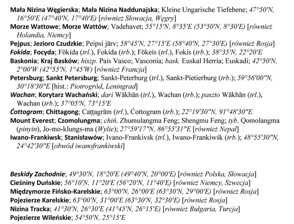
|
|
|
- Allyson Hall
- 6 years ago
- Views:
Transcription
1 The list of Polish geographical names of the world Maciej Zych 21st Session of the East Central and South-East Europe Division of the United Nations Group of Experts on Geographical Names Ljubljana, 26th of November 2015

2 Official List of Polish Geographical Names of the World Prepared by the Commission on Standardization of Geographical Names Outside the Republic of Poland Published by the Head Office of Geodesy and Cartography in nglish/ wpngs_en.php
3 The rules for establishing Polish geographical names of the world Preserve those names that are well-established in the Polish language and form part of Polish cultural heritage Standardization is performed with respect to names of smaller geographic objects from areas historically connected with Poland, as well as for a number of features that Polish names, although often not traditional, were considered useful Old names are replaced with modern ones.
4 Definition of Polish exonym Polish exonym is a name currently used in Poland in the Polish language for a geographical feature situated outside the Polish territory and different in its graphical form from the standardized endonym of this feature. Omission, addition or translation of a generic term is not considered to be a difference in form, nor is a transliteration or transcription of a name originally written in a non-roman script. Omission or addition of diacritics or prefixes forming an integral part of the name is considered to be a difference in graphical form (e.g. Bogota instead Bogotá, Peru instead Perú).
5 Quasi-exonyms Polish geographical names of transboundary features equivalent to at least one endonym in use in one of the countries where the respective feature is located, but different from at least one of such other endonyms (for example: the French endonym La Manche is used in Polish, not the English endonim English Channel). Polish geographical names of features with more than one endonym in the official language or languages of the respective country and identical to one of such names (for example: the Finnish endonym Helsinki is used in Polish, not the Swedish one Helsingfors). Polish geographical names of features whose official endonyms are written in a non-roman script, identical to the name of the feature written in only one of the Romanization methods approved by the Commission, namely transcription or transliteration (for example: the Russian endonym Mocква in the Polish transcription is used Moskwa, not in transliterated form Moskva). Polish geographical names different from the official endonym of the respective feature only because of the translation or omission of a generic term (for example Zatoka Alaska standing for the Gulf of Alaska).
6 Works on new list based on 12 volumes of Geographical Names of the World beginning of 2010 start of works end of 2013 publication of list 34 Commission s meetings 5266 new names 512 changes of names 267 deletion of names
7 Excluded names Names identical to the original ones: Berlin Amsterdam Lombardia [Lombardy], Alaska Tasmania Niger Names identical to the forms created by means of all recommended Romanization methods (transcription and transliteration: Krasnojarsk [Krasnoyarsk] (Красноярск in Russian) Lida (Ліда in Belarusian and Лида in Russian) Astana (Астана in Kazakh and Russian)

8 Number of names

9 Number of names

10 Parts of the list

11 Names of the great regional units and oceans
12 Introductory information from the list of country names
13 Categories of features Administrative units Localities Parts of localities Research stations Oases Economic regions Lands, regions Seas Gulfs and bays Straits Other sea water bodies Ice shelves Ice fronts Lakes Bays of lakes Groups of lakes Rivers Canals Waterfalls Glaciers Swamps Salt pans Islands Groups of islands, archipelagos Islands on lakes or rivers Groups of islands and archipelagos on lakes or rivers Reefs Peninsulas Peninsulas on lakes Capes Coasts Isthmuses River deltas Lake districts Lowlands, plains Valleys Basins High plains Highlands, plateaus Mountains Peaks Passes Deserts Steppes Forests, woods Caves Artesian basins Other natural features Areas of environment protection

14 5,238 names Belarus: 1,624 names Ukraine: 1,468 names Lithuania: 836 names Category localities


15 Part 8. Undersea features
16 Arrangement of entries
17 Arrangement of entries
18 Arrangement of entries

19 Arrangement of entries coordinates

20 Arrangement of entries coordinates

21 Arrangement of entries additional information
22 Name index

23 The inset contains the English translation of: editorial pages table of contents From the Publisher Preface Introduction Romanization rules explanation of abbreviations footnotes contained in the publication information about name index Inset in English
24 Further works The second edition: by the end of 2018 The names from the list will be included in the National Register of Geographical Names in its module related to Polish geographical names of the world. The list is regurally updated by the Commission. Information on the updates is available on the Commission s website (

25 Further works The expansion of information on individual names: establishing adjectives for certain names establishing genitives and locatives for selected names adding to endonyms originally written in non-roman scripts their original notation provide pronunciations for selected Polish names adding information on superordinate object related to objects that are part of thereof
26 Further works The list of selected Polish names for buildings and other urban objects is also prepared. This list will be published as a supplement to the Official List of Polish Geographical Names of the World.
27 Thank you
Toponymic guidelines of Poland for map editors and other users. Fourth revised edition. Submitted by Poland*
 UNITED NATIONS Working Paper GROUP OF EXPERTS ON No. 27 GEOGRAPHICAL NAMES Twenty-sixth session Vienna, 2-6 May 2011 Item 19 of the provisional agenda Toponymic guidelines for map editors and other editors
Resolutions from the Tenth United Nations Conference on the Standardization of Geographical Names, 2012, New York*
 UNITED NATIONS GROUP OF EXPERTS ON GEOGRAPHICAL NAMES Twenty-eighth session New York, 28 April 2 May 2014 GEGN/28/9 English Resolutions from the Tenth United Nations Conference on the Standardization of
TOPONYMIC DATA FILES AND GAZETTEERS COUNTRY NAMES TOPONYMIC GUIDELINES FOR MAP AND OTHER EDITORS EXONYMS STANDARDIZATION IN MULTILINGUAL AREAS
 United Nations Group of Experts on Geographical Names Seventeenth Session New York, 13-24 June 1994 Items 9, 12, 14, 15, 16 of the Provisional Agenda Working No. 28 Paper 9 12 14 15 16 TOPONYMIC DATA FILES
UNIT 2 WARM UP. List the OCEANS. Bonus: Name the Largest LAKE on Earth
 UNIT 2 WARM UP List the OCEANS Bonus: Name the Largest LAKE on Earth Land Forms Land Mountain Hill Cliff Butte Mesa Plateau Cave Volcano Desert Plains Prairie Steppe Marsh Swamp Tundra Glacier Continent
LIST OF DOCUMENTS* GROUP OF EXPERTS ON GEOGRAPHICAL NAMES. Twenty-seventh session 15 June 2016 New York, 28 April 2 May 2014
 UNITED NATIONS GROUP OF EXPERTS ON GEOGRAPHICAL NAMES GEGN/29/5/Rev.4 Twenty-seventh session 15 June 2016 New York, 28 April 2 May 2014 LIST OF DOCUMENTS* * Prepared by the UNGEGN Secretariat Symbol Title/Country
Economic and Social Council
 UNITED NATIONS E Economic and Social Council oistr. LIMITED E/CONF.74/L.69 24 August 1982 ENGLISH ONLY Fourth United Nations Conference on the Standardization of Geographical Names Geneva, 24 August to
ORLD G EOGRAPHY BASIC. NotB oring. Inventive Exercises to Sharpen Skills and Raise Achievement. Imogene Forte & Marjorie Frank
 The BASIC NotB oring SERIES SOCIAL IP 402-0 STUDIES SKILLS MIDDLE GRADES ORLD G EOGRAPHY Inventive Exercises to Sharpen Skills and Raise Achievement Series Concept & Development by Imogene Forte & Marjorie
What is a landform? These shapes (except for bodies of water) on the earth s surface are all examples of landforms.
 on the earth s surface are all examples of landforms.") Landforms What is a landform? These shapes (except for bodies of water) on the earth s surface are all examples of landforms. archipelago a large group of many islands. The Hawaiian Islands Lighthouse
Landforms What is a landform? These shapes (except for bodies of water) on the earth s surface are all examples of landforms. archipelago a large group of many islands. The Hawaiian Islands Lighthouse
GEOGRAPHICAL NAMES AS PART OF THE GLOBAL, REGIONAL AND NATIONAL SPATIAL DATA INFRASTRUCTURES
 GEOGRAPHICAL NAMES AS PART OF THE GLOBAL, REGIONAL AND NATIONAL SPATIAL DATA INFRASTRUCTURES Željko HEĆIMOVIĆ, Željka JAKIR, Zvonko ŠTEFAN, Danijela KUKIĆ zeljko.hecimovic@cgi.hr, zeljka.jakir@cgi.hr,
TECHNICAL DOCUMENT R 2 OF THE SPANISH BRAILLE COMMISSION GENERAL CRITERIA FOR PREPARING ADAPTED MAPS FOR VISUALLY IMPAIRED PERSONS
 TECHNICAL DOCUMENT R 2 OF THE SPANISH BRAILLE COMMISSION GENERAL CRITERIA FOR PREPARING ADAPTED MAPS FOR VISUALLY IMPAIRED PERSONS Updated on December 2013 (Version 1) First edition in English, March 2015
Economic and Social Council
 United Nations Economic and Social Council Distr.: General 23 May 2012 Original: English E/CONF.101/100 Tenth United Nations Conference on the Standardization of Geographical Names New York, 31 July 9
E/CONF.105/75/CRP.75. Report of the Republic of Belarus
 E/CONF.105/75/CRP.75 23 June 2017 Original: Russian 11 th United Nations Conference on the Standardization of Geographical Names New York, 8-17 August 2017 Item 5 of the provisional agenda* Reports by
Unit 1: Geography. For additional information, refer to this website: 1 G e o g r a p h y
 Unit 1: Geography For additional information, refer to this website: http://mryoungtms.weebly.com/ 1 G e o g r a p h y Continents and Oceans SOL USI. 2a Essential Understanding: Continents are large land
Guidelines for the consistent use of place names in Australia
 5 June 2002 English only Eighth United Nations Conference on the Standardization of Geographical Names Berlin, 27 August-5 September 2002 Item 9 (e) of the provisional agenda* National standardization:
Unit 1: Geography GeoTrekkers in the Western Hemisphere. Illustrated Glossary
 Unit 1: Geography GeoTrekkers in the Western Hemisphere Illustrated Glossary adapt to change in order to fit new condi/ons archipelago a group or chain of islands clustered together in a sea or ocean bodies
World Geography Unit 14 Suggested Dates Australia and the Pacific Realm 1 week 6 th 6 weeks. in the Pacific Realm?
 World Geography Unit 14 Title Suggested Dates Australia and the Pacific Realm 1 week 6 th 6 weeks Big Idea/Enduring Understanding The components of culture affect the way people live and shape the characteristics
Current Status of the Standardization of Geographical Names in Cambodia
 1 Current Status of the Standardization of Geographical Names in Cambodia His Excellency Ith Sotha, Under Secretary of States, MLMUPC Mr Chharom Chin, Deputy Director, Geography Department, MLMUPC Mr Narith
Report of Eastern Europe, Northern and Central Asia Division
 UNITED NATIONS GROUP OF EXPERTS WORKING PAPER ON GEOGRAPHICAL NAMES NO. 24/4 Twenty-ninth session Bangkok, Thailand, 25 29 April 2016 English Item 4 of the Provisional Agenda Report of the Divisions Report
United States of America Geography
 United States of America Geography Part I by Sonja E. Schild LearnSmart Publishing Co. Vancouver, BC, Canada Phone: (604) 433-1347 ISBN 0-9694445-3-9 Notice! All rights reserved. Permission to reproduce
Unit 1: Basics of Geography Test Review
 Name Date Period Unit 1: Basics of Geography Test Review Directions: Reading the following sections and complete the questions, charts, and diagrams. Types of Maps Maps that have a particular theme are
Identification of Islands and Standardization of Their Names
 Identification of Islands and Standardization of Their Names Submitted by INDONESIA UNITED NATIONS GROUP OF EXPERTS ON GEOGRAPHICAL NAMES Eleventh United Nations Conference on the Standardization of Geographical
Activities relating to the Working Group on Toponymic Terminology: List of proposed new terms. Submitted by the Convenor of the Working Group **
 UNITED NATIONS E/CONF.98/CRP.68 ECONOMIC AND SOCIAL COUNCIL 14 August 2007 Ninth United Nations Conference on the Standardization of Geographical Names New York, 21-30 August 2007 Item 14 of the provisional
OUR COUNTRY INDIA LOCATIONAL SETTING
 7 India is a country of vast geographical expanse. In the north, it is bound by the lofty Himalayas. The Arabian Sea in the west, the Bay of Bengal in the east and the Indian Ocean in the south, wash the
* E/C ONF * "Prepared by the Directorate of Geodesy and Cartography, Ministry of Regional Development and Public Works.
 3 September 2002 Original: Engiish Eighth United Nations Conference on the Standardization of Geographical Names Berlín, 27 August-5 September 2002 Item 4 of the provisional agenda" REPORTS BY GOVERNMENTS
Turkey National Report
 UNITED NATIONS Working Paper GROUP OF EXPERTS ON No. 26 GEOGRAPHICAL NAMES Twenty-third Session Vienna, 28 March 4 April 2006 Item 5 of the Provisional Agenda: Reports of the division Turkey National Report
Creating an Illustrated Map: New Zealand
 S T U D E N T H A N D O U T A Creating an Illustrated Map: New Zealand You will work in a group of four to create an illustrated map of one type of Pacific island: a continental island. Your illustrated
Iceland. 1. Warm up. A. Talk about the picture and read the essay. B. Discuss the questions about the essay.
 1. Warm up A. Talk about the picture and read the essay. Iceland My country, Iceland, is one of the most beautiful countries on Earth. It is an island country. It is located in Europe, in the North Atlantic
Montgomery County Schools
 (Daily Learning ) SS-07-4.1.1 use a variety of geographic tools (maps, photographs, charts, graphs, databases) to interpret patterns and locations on Earth s surface in early A.D. 1 LT1: I can identify
THE INTERNATIONAL HYDROGRAPHIC ORGANIZATION AND ITS INVOLVEMENT WITH GEOGRAPHICAL PLACE NAMES
 International Hydrographie Review, Monaco, LXXV(1), March 1998 THE INTERNATIONAL HYDROGRAPHIC ORGANIZATION AND ITS INVOLVEMENT WITH GEOGRAPHICAL PLACE NAMES by Adam J. KERR' INTRODUCTION It may be useful
2008 SIVECO Romania. All Rights Reserved. Geography. AeL econtent Catalogue
 2008 SIVECO Romania. All Rights Reserved. Geography AeL econtent Catalogue The Earth's Movements Recommended for two hours of teaching. AeL Code: 352. 2. The Earth Rotation Movement in 24 hours 3. The
Essential Questions What are the major physical components of the world, and how are they represented on a map? 3.4
 Third Grade Social Studies Unit One Six Weeks GEOGRAPHY Originally compiled by Russellville In order for students to understand that geography influences the development of a region as well as the interactions
By Geri Flanary To accompany AP Human Geography: A Study Guide 3 rd edition By Ethel Wood
 Session 1 By Geri Flanary To accompany AP Human Geography: A Study Guide 3 rd edition By Ethel Wood WHAT IS DEMOGRAPHY? It is the scientific or statistical study of population. It comes from the Greek
Europe, Canada, Latin America, & Australia
 Europe, Canada, Latin America, & Australia EUROPE SS6G8 The student will locate selected features of Europe. a. Locate on a world and regional political- physical map: the Danube River, Rhine River, English
The United States & Canada. A Regional Study of Anglo America
 A Regional Study of Anglo America Landform Regions of the United States & Canada world leaders in agricultural and industrial production because of... VAST LANDS stretch from the Atlantic Ocean on the
discussion of North America s physical features, including its landforms and bodies of
 Chapter 7 Natural Environments of North America Chapter 7 focuses on the natural environments of North America. The chapter opens with a discussion of North America s physical features, including its landforms
Helen Kerfoot. Former Chair, UNGEGN / Emeritus Scientist, Natural Resources Canada
 Geographic names authorities, standardization and international cooperation Helen Kerfoot Former Chair, UNGEGN / Emeritus Scientist, Natural Resources Canada BGN at 100 years In recognition of international
Oklahoma Academic Standards Science Grade: 6 - Adopted: 2014
 Main Criteria: Oklahoma Academic Standards Secondary Criteria: Subjects: Science, Social Studies Grade: 6 Correlation Options: Show Correlated OK.6-LS. Oklahoma Academic Standards Science Grade: 6 - Adopted:
PHYSICAL FEATURES OF EUROPE. Europe Unit
 PHYSICAL FEATURES OF EUROPE Europe Unit PENINSULA OF PENINSULAS Europe is a large peninsula that consists of many smaller peninsulas Most places in Europe are no more than 300 miles from an ocean or sea
E/CONF.105/115/CRP.115***
 E/CONF.105/115/CRP.115*** 30 June 2017 Original: English 11 th United Nations Conference on the Standardization of Geographical Names New York, 8-17 August 2017 Item 9a) of the provisional agenda* National
Geography is the study of the earth, it s land, it s people and it s environments. When you study geography, you should be looking at five distinct
 I.N pg. 9 Geography is the study of the earth, it s land, it s people and it s environments. When you study geography, you should be looking at five distinct themes. LOCATION PLACE REGION MOVEMENT HUMANENVIRONMENTAL
What landforms make up Australia?!
 What landforms make up Australia? The tectonic forces of folding, faulting and volcanic activity have created many of Australia's major landforms. Other forces that work on the surface of Australia, and
Understanding Projections
 GEOGRAPHY SKILLS 1 Understanding Projections The earth is a sphere and is best shown as a globe. For books and posters, though, the earth has to be represented as a flat object. To do this, mapmakers create
Downloaded from
 I II III IV V VI Define the following terms:- a) Orbitb) Meteoroids c) Celestial bodies GEOGRAPHY ASSIGNMENTS The Earth In The Solar System d) Satellite e) Comets Give one word answers:- a) Blue planet
Developed in Consultation with Florida Educators
 Developed in Consultation with Florida Educators Table of Contents Next Generation Sunshine State Standards Correlation Chart... 7 Benchmarks Chapter 1 The Practice of Science...................... 11
MASSACHUSETTS HISTORY & SOCIAL SCIENCE LEARNING STANDARDS Grade 6 HISTORY AND GEOGRAPHY
 Massachusetts History and Social Science Curriculum Framework Learning Standards, World Geography (Grade 6) Grade 6 HISTORY AND GEOGRAPHY 1. Use map and globe skills learned in prekindergarten to grade
RESOLUTIONS ADOPTED AT THE NINE UNITED NATIONS CONFERENCES ON THE STANDARDIZATION OF GEOGRAPHICAL NAMES
 RESOLUTIONS ADOPTED AT THE NINE UNITED NATIONS CONFERENCES ON THE STANDARDIZATION OF GEOGRAPHICAL NAMES 1967, 1972, 1977, 1982, 1987, 1992, 1998, 2002, 2007 * * * * * * A. LISTED BY SUBJECT B. CROSS-REFERENCED
Chinle USD CURRICULUM GUIDE
 URRIULU GUIDE SUBJET: Social Studies GRADE: 3 TIELINE: 1 st Quarter Performance Obj.-astery Level Strand 3: ivic/government oncept 4: Rights, Responsibilities, and Roles of itizenship PO 1. Describe the
Chapter 21 Southwest Asia: Harsh & Arid Lands
 Name Hour Chapter 21 Southwest Asia: Harsh & Arid Lands Essential Question: How has the physical geography of Asia influenced the development of these regions (i.e. history, population distribution, &
Sample. Used by Permission
 Editors Dona Herweck Rice Walter Kelly, M.A. Editorial Project Managers Evan D. Forbes, M.S. Ed. Ina Massler Levin, M.A. Editor-in-Chief Sharon Coan, M.S. Ed. Illustrators Agi Palinay Johanna Hornbostel
Economic and Social Council
 United Nations Economic and Social Council Distr.: General 15 May 2012 Original: English E/CONF.101/4 Tenth United Nations Conference on the Standardization of Geographical Names New York, 31 July 9 August
EQ: Discuss main geographic landforms of the U.S. & Canada and examine varied landforms in relation to their lifestyles.
 EQ: Discuss main geographic landforms of the U.S. & Canada and examine varied landforms in relation to their lifestyles. Places & Terms for Discussion Appalachian Mountains Great Plains Canadian Shield
Sec$on 1: Geography and Early China. How does China s geography affect the culture?
 Sec$on 1: Geography and Early China How does China s geography affect the culture? Con$nents of the World Label the continents. Where is China located? Where is China located? In your groups, begin filling
WS/FCS Unit Planning Organizer
 WS/FCS Unit Planning Organizer Subject(s) Social Studies Conceptual Lenses Grade/Course 6 th Geography Unit of Study Unit 1: Human Geography Civilization Unit Title Social Studies 101 Culture Pacing 12
Country Fiche Lithuania
 Country Fiche Lithuania Updated June 2018 1. General information The Lithuanian maritime space is delimited by the Decree of the Government of the Republic of Lithuania of 6 December, 2004, No. 1597 and
United Nations Group Of Experts On Geographical Names
 Rudolph MATINDAS, Indonesia or William WATT, Australia Key words: place names, UNGEGN SUMMARY UNGEGN Discussing the strategic aims of UNGEGN and its divisional structure, future direction, and the benefits
MAPS MAPS MAPS.
 www.atozmapsonline.com MODERN MAPS MAPS MAPS MAPS AtoZ Maps Online TM is the world s most comprehensive collection of royalty-free downloadable maps for schools, academic institutions, and public libraries.
UNIT 4: POLITICAL ORGANIZATION OF SPACE
 UNIT 4: POLITICAL ORGANIZATION OF SPACE Advanced Placement Human Geography Session 1 ADVANCED PLACEMENT HUMAN GEOGRAPHY REVIEW SESSIONS: UNIT FOUR By Geri Flanary To accompany AP Human Geography: A Study
STANDARDISATION OF MARITIME GEOGRAPHICAL NAMES: The Role of the International Hydrographic Organization
 STANDARDISATION OF MARITIME GEOGRAPHICAL NAMES: The Role of the International Hydrographic Organization Ing en chef Michel Huet International Hydrographic Bureau 4, quai Antoine 1 er MC 98011 - Monaco
Training Course on Toponymy
 Training Course on Toponymy Vienna,, 16 March 4 April 2006 United Nations Group of Experts on Geographical Names Dutch- and German-speaking Division Isolde Hausner Toponymic Guidelines for Map and other
19 th November, Wednesday
 19th Session of the East Central and South-East Europe Division of the United Nations Group of Experts on Geographical Names 19 21 November 2008 Zagreb, Croatia PROGRAM OF THE SESSION 19 th November, Wednesday
Grade 4 CURRICULUM MAP CONTENT: Social Studies 17A3 17A4 17A6 17A9 17A10 14A1 14B2 14D1 14E1 17A1 17A2 17A8. Illinois unit
 AUGUST / SEPTEMBER CORE CONTENT Landforms Immunization Government Map skills PROCESS SKILLS/ State maps Hand drawn maps maps maps Landform pictures Diorama mural Food landscapes s 17A3 17A4 17A6 17A9 17A10
netw rks Guided Reading Activity Essential Question: How does geography influence the way people live? Earth's Physical Geography
 Guided Reading Activity Lesson 1 Earth and the Sun Essential Question: How does geography influence the way people live? Looking at Earth Directions: What are the layers that make up Earth? Use your textbook
CHAPTER 1. Geo Challenges 1A to 1D. & World Map Activity
 CHAPTER 1 Geo Challenges 1A to 1D & World Map Activity SELECT YOUR CHALLENGE World Map Activity Challenge 1A Challenge 1B Challenge 1C Challenge 1D Challenge 1A WS PG. 2 STEP #1 Label the largest continent
RESOLUTIONS ADOPTED AT THE TEN UNITED NATIONS CONFERENCES ON THE STANDARDIZATION OF GEOGRAPHICAL NAMES
 RESOLUTIONS ADOPTED AT THE TEN UNITED NATIONS CONFERENCES ON THE STANDARDIZATION OF GEOGRAPHICAL NAMES 1967, 1972, 1977, 1982, 1987, 1992, 1998, 2002, 2007, 2012 * * * * * * A. LISTED BY SUBJECT B. CROSS-REFERENCED
CANADA S LANDFORM REGIONS
 CANADA S LANDFORM REGIONS Canada s Regions Canada is divided into Eight major regions. A Region is an area that is defined on the basis of the presence or absence of certain characteristics: Age of rock
Mapping Diversity in Old and New Netherland
 Your web browser (Safari 7) is out of date. For more security, comfort and Activityengage the best experience on this site: Update your browser Ignore Mapping Diversity in Old and New Netherland How did
World Industrial Regions
 World Industrial Regions North America Industrialized areas in North America Changing distribution of U.S. manufacturing Europe Western Europe Eastern Europe East Asia Manufacturing Regions Fig. 11-3:
Explain the impact of location, climate, natural resources, and population distribution on Europe. a. Compare how the location, climate, and natural
 SS6G10 Explain the impact of location, climate, natural resources, and population distribution on Europe. a. Compare how the location, climate, and natural resources of Germany, the United Kingdom and
Earth s Layers. Earth s Surface
 CHAPTER 1 LESSON 3 Earth s Layers Earth s Surface Key Concepts What are Earth s major landforms and how do they compare? What are the major landform regions of the United States? What do you think? Read
CLLD Cooperation OFFER
 Title of the proposed project (English) CLLD Cooperation OFFER PARKS PROTECTION III - Management, Protection and Economic Development in Protected Areas Type of project (select as many as you want) Cooperation
Terms, People, and Places. Five Themes of Geography: Three Kinds of Maps: Natural Resources: Land Terms: Water Terms:
 Terms, People, and Places Five Themes of Geography: Three Kinds of Maps: Natural Resources: Land Terms: Water Terms: Lesson Objectives Explain how geography impacts human development Analyze how human
Static GK. World Geography. innovation. Assignment 01
 Static GK World Geography innovation Assignment 01 World Geography Practice Assignment 01 Direction for question 1-35: Mark the best option. 1. Which strait separates Europe from Africa? A) Mallaica B)
Wednesday, May 23, 2018
 Wednesday, May 23, 2018 Physical Geography of West Africa Objective: Summarize the main geographic aspects of each country in West Africa. Understand each country s development pattern and their current
WHAT IS THE EARTH MADE OF? LITHOSPHERE AND HYDROSPHERE
 UNIT 8 WHAT IS THE EARTH MADE OF? LITHOSPHERE AND HYDROSPHERE TABLE OF CONTENTS 1 THE STRUCTURE OF THE EARTH... 2 2 THE FORMATION OF THE RELIEF: INTERNAL AND EXTERNAL FORCES.... 2 2.1 Internal forces:
WS/FCS Unit Planning Organizer
 WS/FCS Unit Planning Organizer Subject(s) Social Studies Conceptual Lenses Grade/Course 6 th Geography Unit of Study Unit 1: Human Geography Civilization Unit Title Social Studies 101 Culture Pacing 12
Virginia Regions Study Guide
 Name/Number: Date: Virginia Regions Study Guide Standard VS.2a: SWBAT demonstrate knowledge of the physical geography and native peoples, past and present, of Virginia by locating Virginia and its bordering
About places and/or important events Landmarks Maps How the land is, hills or flat or mountain range Connected to maps World Different countries
 What do you think you know about geography? About places and/or important events Landmarks Maps How the land is, hills or flat or mountain range Connected to maps World Different countries What do you
THE EARTH S RELIEF SOCIAL SCIENCES 1º ESO
 THE EARTH S RELIEF SOCIAL SCIENCES 1º ESO 1. THE STRUCTURE OF THE EARTH The Earth is divided into layers: The crust is the surface layer. It is a thin, solid layer made of rock. The Earth s crust has a
Fourth Grade Social Studies
 AASD SOCIAL STUDIES CURRICULUM Fourth Grade Social Studies Description Fourth Grade Social Studies explores the regions of the United States with particular emphasis on the where students will spotlight
Grade 7 History Mr. Norton
 Grade 7 History Mr. Norton Section 1: Thinking Geographically Section 2: Land and Climates of the United States Section 3: The Tools of History Section 4: Economics and Other Social Sciences Grade 7 History
D.N.D. Hettiarachchi (Hetti) Survey Department, Sri Lanka.
 Survey Department, Sri Lanka.") ADMINISTRATION OF GEOGRAPHICAL NAMES IN SRI LANKA D.N.D. Hettiarachchi (Hetti) Survey Department, Sri Lanka. hettiarachchidnd@gmail.com Country: Sri Lanka What is the official language(s)? Sinhala and
ADMINISTRATION OF GEOGRAPHICAL NAMES IN SRI LANKA D.N.D. Hettiarachchi (Hetti) Survey Department, Sri Lanka. hettiarachchidnd@gmail.com Country: Sri Lanka What is the official language(s)? Sinhala and
Social Studies (4) Social Science
 Social Science") Scope And Sequence Timeframe Unit Instructional Topics 8 Day(s) Course Overview Students will learn about the regions of the United States with emphasis on local and state history, geography, government,
Scope And Sequence Timeframe Unit Instructional Topics 8 Day(s) Course Overview Students will learn about the regions of the United States with emphasis on local and state history, geography, government,
EXTERNAL LAND FORMING PROCESSES
 NAME SCHOOL INDEX NUMBER DATE EXTERNAL LAND FORMING PROCESSES WEATHERING 1 1998 Q 7 (a) (i) What is the difference between weathering and mass wasting (ii) List five processes involved in chemical weathering
Republic of Korea in Czech atlases and geography textbooks. Jan Ptacek, Kartografie Praha
 Republic of Korea in Czech atlases and geography textbooks Jan Ptacek, Kartografie Praha Schools in the Czech republic Primary schools 9 years (age 6 15) Geography from the age of 11, only one year of
Moreton Bay and Key Geographic Concepts Worksheet
 Moreton Bay and Key Geographic Concepts Worksheet The Australian Curriculum: Geography draws on seven key geographic concepts: place scale space environment change interconnection sustainability They are
Economic and Social Council
 United Nations Economic and Social Council Distr.: General 25 May 2012 Original: English E/CONF.101/113 Tenth United Nations Conference on the Standardization of Geographical Names New York, 31 July 9
e Southeast Region of the United Statesg
 e Southeast of the United Statesg - relative location: the location of a place in relation to another place (i.e. south, near, bordering, next to) - barrier islands: located off the southeast coast of
Physical Geography of the United States and Canada Chapter 5 A Land of Contrasts
 Physical Geography of the United States and Canada Chapter 5 A Land of Contrasts Land Area Together the U.S. and Canada cover more than 7 million square miles. In total area, Canada ranks 2 nd and the
2 Georgia: Its Heritage and Its Promise
 TERMS region, erosion, fault, elevation, Fall Line, aquifer, marsh, climate, weather, precipitation, drought, tornado, hurricane, wetland, estuary, barrier island, swamp PLACES Appalachian Mountains, Appalachian
United Nations, UNGEGN, and support for national geographical names standardization programmes
 Philippines, 2018 United Nations, UNGEGN, and support for national geographical names standardization programmes Helen Kerfoot, UNGEGN Cecille Blake, UNGEGN Secretariat What is important to know? Background
Why Geography Matters
 Why Geography Matters Vocabulary words geography relative location absolute location physical feature human feature region modify adapt cause effect geography: The study of the Earth s physical and human
Socorro Independent School District World Geography 3 rd 9 Weeks. Culture. Government. European Terminology
 Unit Essential Questions SE Monday Tuesday Wednesday Thursday Friday Unit 05: Latin America Unit 6: How did the major landforms of Latin America impact its developmen t? How is Latin American history a
HISTORY & GEOGRAPHY STUDENT BOOK. 7th Grade Unit 3
 HISTORY & GEOGRAPHY STUDENT BOOK 7th Grade Unit 3 Unit 3 History and Geography of Our States HISTORY & GEOGRAPHY 703 History and Geography of Our States INTRODUCTION 3 1. LOOKING AT THE UNITED STATES 5
Edgebrook Geography Bee Workshop
 Edgebrook Geography Bee Workshop January 12, 2015 1/13/2015 1 Image from https://www.google.com/search?q=world+map 1/13/2015 2 Two Bees Grade 4-8: National Geographic Society (NGS) Geography Bee School
Report of the United Kingdom Division
 UNITED NATIONS GROUP OF EXPERTS WORKING PAPER ON GEOGRAPHICAL NAMES NO. 41/4 Twenty-ninth session Bangkok, Thailand, 25 29 April 2016 Item 4 of the Provisional Agenda Report of the Divisions Report of
Submitted by ECSEE Division Chairman*
 UNITED NATIONS Working Paper GROUP OF EXPERTS ON No. 3 GEOGRAPHICAL NAMES Twenty-sixth session Vienna, 6-11 May 2011 Item 4 of the provisional agenda Reports of the divisions Report of the East Central
ANNEX 23 RESOLUTION MSC.231(82) ADOPTION OF AMENDMENTS TO THE EXISTING MANDATORY SHIP REPORTING SYSTEM IN THE GULF OF FINLAND
 ADOPTION OF AMENDMENTS TO THE EXISTING MANDATORY SHIP REPORTING SYSTEM IN THE GULF OF FINLAND") RESOLUTION MSC.231(82) (adopted on 5 December 2006) ADOPTION OF AMENDMENTS TO THE EXISTING MANDATORY SHIP REPORTING SYSTEM IN THE GULF OF FINLAND THE MARITIME SAFETY COMMITTEE, RECALLING Article 28(b)
RESOLUTION MSC.231(82) (adopted on 5 December 2006) ADOPTION OF AMENDMENTS TO THE EXISTING MANDATORY SHIP REPORTING SYSTEM IN THE GULF OF FINLAND THE MARITIME SAFETY COMMITTEE, RECALLING Article 28(b)
Weathering Erosion and Deposition. Presented by Kesler Science
 Weathering Erosion and Deposition Presented by Kesler Science Essential Questions: 1. What effects do weathering, erosion, and deposition have on the environment in ecoregions? Weathering Chemical and
Carpathians Unite mechanism of consultation and cooperation for implementation of the Carpathian Convention
 Carpathians Unite mechanism of consultation and cooperation for implementation of the Carpathian Convention Zbigniew Niewiadomski, UNEP/GRID-Warsaw Centre First Joint Meeting of the Carpathian Convention