Downloaded from
|
|
|
- Josephine Mason
- 6 years ago
- Views:
Transcription
1 I II III IV V VI Define the following terms:- a) Orbitb) Meteoroids c) Celestial bodies GEOGRAPHY ASSIGNMENTS The Earth In The Solar System d) Satellite e) Comets Give one word answers:- a) Blue planet of the solar system b) The largest planet of our solar system c) Another name for Milkyway d) The two planets between which the Saturn lies. e) The smallest planet in the solar system f) Constellation that helps us locate the Pole Star. Indicate if the statements are True or False:- a) Asteroids are thought to be pieces of a large planet which exploded b) The sun is the biggest star in the universe c) Planets move around the sun in circular orbits d) The solar system consists of the sun and the eight planets e) Uranus has the most number of satellites in our solar system f) Hydrogen and helium gases are found on the sun. Name all the planets according to their size. Why is Earth known as Blue Planet? Match the following: Column - A 1. The star nearest to earth 2. Planet with the largest orbit 3. Red planet 4. Celestial body closest to earth 5. Planet surrounded by prominent rings. Column - B a. Moon b. Saturn c. Sun d. Mars e. Neptune ============================================== 38
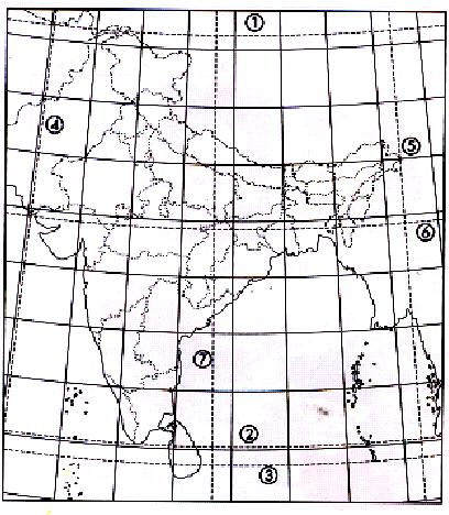
2 I Define the following terms :- a) Equator b) Axis c) Greenwich Mean Time II Fill in the blanks :- III IV V VI Globe Latitude and Longitude d) Arctic Circle e) Geoid a) Lines of latitudes are also called. b) The zone is neither too hot nor too cold. c) is a model of the earth. d) The sun s rays fall over every place within the Torrid zone. e) Frigid zone lies beyond in both the hemispheres. Indian standard time is 5½ hours ahead of London time Keep this in mind and calculate :- (a) G.M.T Time in India (b) IST Time in London 8 AM 1.30 PM AM 5.30 PM 6 PM 6 AM Answer the following questions: a) How are meridians numbered? b) When would the local time of a place A be ahead of place B? Distinguish between: a) Latitudes and Longitudes b) Local time and Standard time. Explain the heat zones of the earth with the help of a diagram. VII On the given outline map label the numbered latitudes and longitudes from 1 to 7. 39
3 ============================================== 40
4 Location & Political Divisions I Fill in the blanks:- a) There are 28 states and Union Territories in India. b) India and have a common border in the North-West. c) Five states of India have common border with the countries of and at different location. d) and country have no access to sea route. e) The southern neighbour of India is. II Give one word: a) The southern tip of India where water of three seas/ ocean meet. b) Two Land lock states. c) Two states on the Western coast. d) The smallest state in area. e) The largest state in area. III Define the following terms. a) Peninsula b) Cape c) Strait d) Isthmus e) Gulf f) Bay 41
5 Locate and Label the Neighbouring Countries and Surrounding Water Bodies Lakshadeep Sea Andaman Sea 42
6 Shade and Name the States of India 43
7 Motions of the Earth I Label a, b, c and d in the given diagram. c 1 b d a II a. c2 b c d Choose the correct option:- a) The apparent movement of the sun is due to the earth s (i) Revolution (ii) Rotation (iii) Elliptical Orbit (iv) Inclined Axis b) Places on the Tropic of Cancer have the longest day on (i) 21 June (ii) 22 December (iii) 21 March (iv) 23 September c) The period of diffused light before sunrise is called (i) Morning (ii) Dusk (iii) Dawn (iv) Evening d) Unequal days and nights on the earth are caused by (i) Rotation (ii) The movement of the sun (iii) Inclination of the earth s axis (iv) Revolution e) On 21 June (i) The sun s rays fall vertically on the Tropic of Cancer at noon. (ii) The Northern Hemisphere has the longest day. (iii) It is winter in the Southern Hemisphere. (iv) All the above. III Distinguish between : a) Rotation and Revolution b) Summer and Winter Solstice 44
 Give the duration of day and night in N and S hemisphere on the above mentioned dates A B Sun V Read the given diagram and answer the questions that follow: (a) (b) a) Mention the dates for a and")
8 IV Label the diagram given belowa) 21 st June b) 22 nd December c) Give the geographical terms for above given dates. d) Name and label all the latitudes drawn. e) Give the duration of day and night in N and S hemisphere on the above mentioned dates A B Sun V Read the given diagram and answer the questions that follow: (a) (b) a) Mention the dates for a and b. b) Give geographical terms for above mentioned dates. 45
9 c) Name the latitude where the sun rays are falling vertically on the above dates. d) What will be the duration of day and night on the earth on the above dates? ============================================== I Fill in the blanks:- Maps f) In a world map, the maximum distortion is at the. g) If a map does not have the north line, the. part is taken as the north. h) The direction to the right of the north line is. i) A. shows the details of a small area on a large scale. II Choose the correct option :- f) Of the following, the map with the smallest scale will be that of (i) Your City (ii) Maharashtra (iii) India (iv) Asia g) To build a school, one would need a (i) Sketch (ii) Plan (iii) Map (iv) Globe c) In the following diagram which arrow indicates the south-west direction? P N X Y Q (i) X (ii) Y (iii) P (iv) Q 46
10 II III d) The symbols used on maps are called conventional symbols because (i) (ii) (iii) (iv) They have been used since ancient times. They are used all over the world under an international agreement. They are the traditional Indian way of showing various features on maps. They were used by British map-makers. e) A sketch is drawn using (a) A Scale (b) Neither a scale nor the north line (c) Both a scale and the north line (d) The North Line f) A map uses a scale in which 1 cm on the map covers 50 metres on the ground. If two places are 4 cm apart on the map, the actual distance between them is (a) 50 Metres (b) 100 Metres (c) 150 Metres (d) 200 Metres Define the following terms: a) Sketch b) Atlas c) Conventional Symbols Describe the main components of a map. d) Scale e) Cartography IV Study the conventional symbols and name the feature numbered 1 to
11 I Fill in the blanks :- II Major Domain of the Earth a) The earth s zones include lithosphere, atmosphere and. b). is the largest continent while. is the smallest. c). is the gas which helps plants to make food, and keeps the earth warm. d) The air pressure. as we go up. e) Southern ocean is formed by combined water of.,. and. f) Wind always blows from. pressure area to. pressure area. Choose the correct option. III a) The continent through which both the Tropic of Cancer and the Tropic of Capricorn pass is (i) North America (ii) Asia (iii) Africa (iv) Europe b) The percentage of oxygen in the air we breathe is (i) 100 (ii) 78 (iii) 21 (iv) 1 c) The Pacific is the largest ocean but the busiest ocean from the point of view of trade is the (i) Pacific (ii) Indian (iii) Arctic (iv) Atlantic d) Depth of ocean or height of land is measured from (i) Ocean floor (ii) Mountain (iii) Sky (iv) Sea level Define the following terms: a) Air pressure b) Isthmus c) Wind d) Strait 48
12 IV V Answer the following questions: a) What is global warming? b) What is the significance of atmosphere? Mark and colour all the continents and oceans on a world map. ============================================== I II III IV Define the following terms: a) Erosion b) Deposition Major Landforms of the Earth Differentiate between: (a) Internal & External processes of the earth. (b) Young and Old fold mountains. c) Peninsula d) Island Give one term for the following: a) Hot molten rock material that flows out of a volcano. b) Plateau which is often called Roof of the World. c) Tremors felt on the surface that originate from within the earth. d) Young fold mountains of S-America. e) Old fold mountain of N-America. Identify the mountain ranges; plateaus and plains (5 each) from the following map. 1 I 2 II a 3 III b Ic 4 IV d e V 5 49
13 V. Draw diagrams: a) To show the up folds and down folds of mountains which are formed by the horizontal forces of compression. b) To show horsts and rift valley formed by the horizontal forces of tension that leads to faulting. ============================================== I Define the following terms: a) Sub-continent b) Delta c) Coral polyp d) Coral Answer the following question: III. (a) (b) (c) India Physical Divisions e) Coral Islands f) Tributary g) Alluvium deposit Name three ranges of Himalayas and give two significant features of each range. Write main features of the Northern Plains. Give four main features of the Peninsular Plateau. Distinguish between: (a) (b) Eastern & Western Coastal plains. Island groups in the Arabian Sea & the Bay of Bengal. ============================================== 50
14 MAP WORK Shade and Label the Major Physical Divisions of India Peninsular Plateau 51
THE EARTH AND ITS REPRESENTATION
 UNIT 7 THE EARTH AND ITS REPRESENTATION TABLE OF CONTENTS 1 THE EARTH AND THE SOLAR SYSTEM... 2 2 THE EARTH S MOVEMENTS... 2 2.1 Rotation.... 2 2.2 The revolution of the Earth: seasons of the year....
Geography Class 6 Chapters 3 and
 CHAPTER 3 MOTIONS OF THE EARTH The Earth is always travelling in Space. That makes each person on Earth, a Space Traveller. No one feels the movement of the Earth because humans are too tiny when compared
THE EARTH. Some animals and plants live in water. Many animals, plants and human beings live on land.
 THE EARTH The Earth is our planet. It is round and it looks blue from space. The Earth has everything that living beings need: air, water, and heat and light from the Sun. On our planet there is water,
INTERNATIONAL INDIAN SCHOOL, RIYADH HALF YEARLY
 INTERNATIONAL INDIAN SCHOOL, RIYADH HALF YEARLY 2018-19 STD V Fill in the blanks: WORKSHEET LESSON - 1 KNOW YOUR PLANET SOCIAL STUDIES 1 A book containing maps is called an _ 2 A Flemish map maker, collection
CLASS VI GEOGRAPHY FORTNIGHTLY SYLLABUS NEW SESSION 2 ND APRIL Sub Topic. Introduction- The different celestial bodies.
 CLASS VI GEOGRAPHY FORTNIGHTLY SYLLABUS 08-09 NEW SESSION ND APRIL 08 S. No Fortnight Days Main Topic. nd April 3 th April Chapter The Earth in the Solar system Sub Topic - The different celestial bodies
Chapter 1 Section 2. Land, Water, and Climate
 Chapter 1 Section 2 Land, Water, and Climate Vocabulary 1. Landforms- natural features of the Earth s land surface 2. Elevation- height above sea level 3. Relief- changes in height 4. Core- most inner
The Earth and its representation
 GEOGRAPHY UNIT 1 The Earth and its representation THE SOLAR SYSTEM AND THE EARTH THE SOLAR SYSTEM The solar system is a planetary system. Is a group of astronomical objects who surround a star, in this
Dr. M.K.K. Arya Model School Class-V, Social Science Assignment Ch-1, Globe The Model of the Earth Answer the following:- Q.1.
 Class-V, Social Science Assignment Ch-1, Globe The Model of the Earth - Q.1. What are the disadvantages/demerits of a globe? Ans. Some disadvantages of globe are: a) It is difficult to carry. b) It cannot
Major Domain of the Earth
 Major Domain of the Earth The surface of the earth is a complex zone in which three main components of the environment meet, overlap and interact. The solid portion of the earth on which we live is called
netw rks Guided Reading Activity Essential Question: How does geography influence the way people live? Earth's Physical Geography
 Guided Reading Activity Lesson 1 Earth and the Sun Essential Question: How does geography influence the way people live? Looking at Earth Directions: What are the layers that make up Earth? Use your textbook
Seasons & Time.
 Seasons & Time Earth s Movements Rotation Movement of Earth Around the Sun Elliptical Orbit Revolution 24 Hours (1 Day) 365 Days (1 Year) The Earth s Revolution & the Tilt of the axis cause variations
GLOBE : LATITUDES AND LONGITUDES
 2 Figure 2.1 : Globe Let s Do Take a big round potato or a ball. Pierce a knitting needle through it. The needle resembles the axis shown in a globe. You can now move the potato or the ball around this
Unit 1: Basics of Geography Test Review
 Name Date Period Unit 1: Basics of Geography Test Review Directions: Reading the following sections and complete the questions, charts, and diagrams. Types of Maps Maps that have a particular theme are
Downloaded from
 Geo Globe : Latitudes and Longitudes 1.Suppose the time at 30 east is 2 p.m. then what is the time at Greenwich? (A) 2 p.m. (B) 12 p.m. (C) 1 p.m. (D) Cannot find 2.What does the term 'Grid' mean
Primrose Schools NATIONAL PRIMTALENT OLYMPIAD EXAMINATIONS GEOGRAPHY
 Primrose Schools Affiliated to the CISCE Board for ICSE & ISC Affiliated to the Cambridge University for IGCSE, AS & A Level An ISO 9001:2015 Certified Institution NATIONAL PRIMTALENT OLYMPIAD EXAMINATIONS
The Earth-Moon-Sun System
 chapter 7 The Earth-Moon-Sun System section 2 Time and Seasons What You ll Learn how to calculate time and date in different time zones how to distinguish rotation and revolution what causes seasons Before
C) the seasonal changes in constellations viewed in the night sky D) The duration of insolation will increase and the temperature will increase.
 the seasonal changes in constellations viewed in the night sky D) The duration of insolation will increase and the temperature will increase.") 1. Which event is a direct result of Earth's revolution? A) the apparent deflection of winds B) the changing of the Moon phases C) the seasonal changes in constellations viewed in the night sky D) the
1. Which event is a direct result of Earth's revolution? A) the apparent deflection of winds B) the changing of the Moon phases C) the seasonal changes in constellations viewed in the night sky D) the
Map Skills Lesson 1. Materials: maps, pencils, Lesson 1 Worksheet, strips of paper, grid paper
 Map Skills Lesson 1 Use cardinal directions, map grids, scales, and titles to locate places on a map. Interpret a map using information from its title, compass rose, scale, and legend. Vocabulary: map,
astronomy A planet was viewed from Earth for several hours. The diagrams below represent the appearance of the planet at four different times.
 astronomy 2008 1. A planet was viewed from Earth for several hours. The diagrams below represent the appearance of the planet at four different times. 5. If the distance between the Earth and the Sun were
The structure of the Earth and how its motion creates the seasons. The landforms of the earth and the forces that shape the land.
 The structure of the Earth and how its motion creates the seasons. The landforms of the earth and the forces that shape the land. The role of wind and water in creating climate. The different climate and
Introduction to Geography
 Introduction to Geography ropic of Cancer 3½ N Arctic Circle 90 N Prime Meridian 0 Arctic Ocean Mississippi R. Appalachian Mts. Europe Rocky Mountains N. America Atlantic Gulf of Ocean Mexico Caribbean
1. The Sun is a huge ball of very hot gas in space, which radiates heat and light in one direction.
 PLEASE ANSWER YOUR QUESTIONS ON THIS PROVIDED QUESTION PAPER. EACH QUESTION IS FOLLOWED BY ANSWERS MARKED A AND B, OR A, B, C AND D. ONLY ONE ANSWER IS CORRECT. CHOOSE THE MOST CORRECT ANSWER AND CIRCLE
Geographic Grid -Latitudes and Longitudes
 GEOGRAPHY STD 9 Geographic Grid -Latitudes and Longitudes 2018-2019 Q1. Define Geographic Grid. The network of latitudes and longitudes are known as Geographic Grid. They help us to locate places on the
GEOGRAPHY STD.9 LATITUDE & LONGITUDE
 GEOGRAPHY STD.9 LATITUDE & LONGITUDE 1. What is the Earth Grid? A. The complete network of meridians & parallels is called the earth Grid. 2. What is Latitude? A. The latitude of a place is the distance
 Name Period Parent Signature Geography/Map Skills Study Guide *For extra practice with these skills, check out Mr. Kath s website: http://rkath.weebly.com/activities--links.html Continents and Oceans of
Seasons. What causes the seasons?
 Questions: Seasons What causes the seasons? How do we mark the progression of the seasons? What is the seasonal motion of the sun in the sky? What could cause the seasonal motion of the sun to change over
Cardinal and Intermediate Directions:
 Name Period Parent Signature Due Date: (TBA) Geography/Map Skills Study Guide Continents and Oceans of the World: Label the continents (7) and oceans (4) on the lines below the map. 1 11 3 5 4 8 2 9 10
Understanding Projections
 GEOGRAPHY SKILLS 1 Understanding Projections The earth is a sphere and is best shown as a globe. For books and posters, though, the earth has to be represented as a flat object. To do this, mapmakers create
A Living Planet. The Earth Inside and Out
 A Living Planet The Earth Inside and Out Planet Earth Earth s Rotation, Revolution, and Tilt Most of Earth s energy comes from the Sun, which we call solar energy. Imagine that the Earth has an imaginary
... Europe. Based on Bloom s Taxonomy. Environment Interactions Movement. Human & Location. Regions. Place
 ... Europe Location Place Human & Environment Interactions Movement Regions LEVEL 1 Knowledge Match Show or Label List Information Recall Details (5Ws + H) Find Information LEVEL 2 Comprehension Describe
The City School /PAF Chapter / Prep + Senior I Section / Worksheet for Intervention Class (1 st Term)/Geography /Class 6 Page 2 of 22
/Geography /Class 6 Page 2 of 22") The City School PAF Chapter Prep Section GEOGRAPHY Year 6 Worksheets for Intervention Classes The City School /PAF Chapter / Prep + Senior I Section / Worksheet for Intervention Class (1 st Term)/Geography
The City School PAF Chapter Prep Section GEOGRAPHY Year 6 Worksheets for Intervention Classes The City School /PAF Chapter / Prep + Senior I Section / Worksheet for Intervention Class (1 st Term)/Geography
Full name:.. Date:. School: Teacher:
 CONTENTS: 1. The solar system 2. The representation of the Earth 3. The cardinal points 4. The geographical coordinates 5. The scale 6. Earth movements Full name:.. Date:. Class: School: Teacher: A Asteroid:
Earth Moon Motions A B1
 Earth Moon Motions A B1 1. The Coriolis effect provides evidence that Earth (1) rotates on its axis (2) revolves around the Sun (3) undergoes cyclic tidal changes (4) has a slightly eccentric orbit 9.
OUR COUNTRY INDIA LOCATIONAL SETTING
 7 India is a country of vast geographical expanse. In the north, it is bound by the lofty Himalayas. The Arabian Sea in the west, the Bay of Bengal in the east and the Indian Ocean in the south, wash the
SECOND GRADE 1 WEEK LESSON PLANS AND ACTIVITIES
 SECOND GRADE 1 WEEK LESSON PLANS AND ACTIVITIES UNIVERSE CYCLE OVERVIEW OF SECOND GRADE UNIVERSE WEEK 1. PRE: Discovering stars. LAB: Analyzing the geometric pattern of constellations. POST: Exploring
Complete Geography Overview: Year 1 to Year 6
 Option 1 Complete Geography Overview: Year 1 to Year 6 Autumn Term Spring Term Summer Term Year 1 Where do I live? Around the World The Four Seasons Year 2 At the Farm Let s go on Safari My World and Me
1. The Sun is the largest and brightest object in the universe. 2. The period that the Earth takes to revolve once around the Sun is approximately a
 PLEASE ANSWER YOUR QUESTIONS ON THIS PROVIDED QUESTION PAPER. EACH QUESTION IS FOLLOWED BY ANSWERS MARKED A AND B, OR A, B, C AND D. ONLY ONE ANSWER IS CORRECT. CHOOSE THE MOST CORRECT ANSWER AND CIRCLE
SMART NOTES ON INDIAN GEOGRAPHY - 1
 ON INDIAN GEOGRAPHY - 1 Point. Precise. Powerful. www.thesmartnotes.org ON INDIAN GEOGRAPHY - 1 To our Hardworking and persistence aspirants. Success is going from failure to failure without losing enthusiasm.
Chapter 1 Introduction to the Earth
 Chapter 1 Introduction to the Earth What is Geography? The study of the earth as the home of humankind. Greek - Eratosthenes Father of Geography Geo means Earth Graphy means to write Study how things are
World Geography Chapter 3
 World Geography Chapter 3 Section 1 A. Introduction a. Weather b. Climate c. Both weather and climate are influenced by i. direct sunlight. ii. iii. iv. the features of the earth s surface. B. The Greenhouse
New National Curriculum Geography Skills Planning KS1
 New National Curriculum Geography Skills Planning KS1 Enquiry Question Objective-essential knowledge skills or understanding Locational Knowledge Standards /Success Criteria Lesson progression over half
Practice Questions: Seasons #1
 1. Seasonal changes on Earth are primarily caused by the A) parallelism of the Sun's axis as the Sun revolves around Earth B) changes in distance between Earth and the Sun C) elliptical shape of Earth's
1 What Is Climate? TAKE A LOOK 2. Explain Why do areas near the equator tend to have high temperatures?
 CHAPTER 17 1 What Is Climate? SECTION Climate BEFORE YOU READ After you read this section, you should be able to answer these questions: What is climate? What factors affect climate? How do climates differ
CHAPTER 1. Geo Challenges 1A to 1D. & World Map Activity
 CHAPTER 1 Geo Challenges 1A to 1D & World Map Activity SELECT YOUR CHALLENGE World Map Activity Challenge 1A Challenge 1B Challenge 1C Challenge 1D Challenge 1A WS PG. 2 STEP #1 Label the largest continent
UNIT 1: THE PLANET EARTH
 UNIT 1: THE PLANET EARTH How many planets are there in our Solar System? What is the Equator? Why does life exist in our planet? Does The Earth move? What is a map? 1. Planet Earth TOPICS 2. Movements
Module 2: Mapping Topic 2 Content: Determining Latitude and Longitude Notes
 Introduction In order to more easily locate points on a globe or map, cartographers designed a system of imaginary vertical lines (also called parallels) and horizontal lines (also called meridians) that
The Earth is a Rotating Sphere
 The Earth is a Rotating Sphere The Shape of the Earth Earth s Rotation ( and relative movement of the Sun and Moon) The Geographic Grid Map Projections Global Time The Earth s Revolution around the Sun
Map Skills Unit. Note taking unit
 Map Skills Unit Note taking unit Introduction To learn about the Earth, we are going to learn about two geographic tools you can use.globes and maps. Globe A globe is a round model of the planet Earth
... Asia. Based on Bloom s Taxonomy. Human & Movement. Location Place. Regions. Environment. Interactions
 ... Asia Location Place Human & Environment Interactions Movement Regions LEVEL 1 Knowledge Match Show or Label List Information Recall Details (5Ws + H) Find Information LEVEL 2 Comprehension LEVEL 3
WHAT IS THE EARTH MADE OF? LITHOSPHERE AND HYDROSPHERE
 UNIT 8 WHAT IS THE EARTH MADE OF? LITHOSPHERE AND HYDROSPHERE TABLE OF CONTENTS 1 THE STRUCTURE OF THE EARTH... 2 2 THE FORMATION OF THE RELIEF: INTERNAL AND EXTERNAL FORCES.... 2 2.1 Internal forces:
1. Which graph best represents the altitude of Polaris observed at northern latitude positions on the Earth's surface?
 1. Which graph best represents the altitude of Polaris observed at northern latitude positions on the Earth's surface? A) 4. The diagram below shows an observer measuring the altitude of Polaris. B) C)
Unit 1: Geography. For additional information, refer to this website: 1 G e o g r a p h y
 Unit 1: Geography For additional information, refer to this website: http://mryoungtms.weebly.com/ 1 G e o g r a p h y Continents and Oceans SOL USI. 2a Essential Understanding: Continents are large land
Cartesian Coordinates Need two dimensional system 2 number lines perpendicular to each other X-axis is horizontal Y-axis is vertical Position relative
 General Physical Science Chapter 15 Place and Time Space and Time Einstein Space and time related Single entity Time is the 4 th dimension! Cartesian Coordinates Need some system to tell us where something
The following terms are some of the vocabulary that students should be familiar with in order to fully master this lesson.
 Lesson 211: EARTH'S SEASONS Students learn the complex geometry and planetary motions that cause Earth to have four distinct seasons. Fundamental Questions Attempting to give thorough and reasonable answers
Geography Route Planner
 Geography Route Planner Introduction to Route Planners Route Planners outline the Key Stages 1-3 curriculum to be taught within each campus of the Bury St Edmunds Trust. Each Route Planner has been designed
3. The diagram below shows the Moon at four positions in its orbit around Earth as viewed from above the North Pole.
 1. Which object orbits Earth in both the Earth-centered (geocentric) and Sun-centered (heliocentric) models of our solar system? (1) Polaris (3) the Sun (2) Venus (4) the Moon 2. A cycle of Moon phases
CHAPTER 2 SKILL SHEET 2: CELESTIAL NAVIGATION
 CHAPTER 2 SKILL SHEET 2: CELESTIAL NAVIGATION Before the invention of GPS technology, how were people on ships far at sea, out of the sight of land, able to tell where they were? For thousands of years
Atlases. About Chapter 2. Chapter II: Earth in Space
 Chapter 2: Earth in Space Class Workbooks Each chapter will have a mapping section You will receive a class workbook to KEEP You need to take this to class when it is announced the day before if you forget
SUBJECT : GEOGRAPHY ROTATION AND REVOLUTION This paper consists of 5 printed pages.
 SUBJECT : GEOGRAPHY ROTATION AND REVOLUTION 2017-2018 This paper consists of 5 printed pages. 1. Name the motions of the earth. A. They are Rotation and Revolution. 2. What is Rotation? A. Rotation is
ORLD G EOGRAPHY BASIC. NotB oring. Inventive Exercises to Sharpen Skills and Raise Achievement. Imogene Forte & Marjorie Frank
 The BASIC NotB oring SERIES SOCIAL IP 402-0 STUDIES SKILLS MIDDLE GRADES ORLD G EOGRAPHY Inventive Exercises to Sharpen Skills and Raise Achievement Series Concept & Development by Imogene Forte & Marjorie
Map Skills Test. 1. What do we call a person who makes maps? a. mapographer b. cartographer c. geologist d. archaeologist
 Map Skills Test 1. What do we call a person who makes maps? a. mapographer b. cartographer c. geologist d. archaeologist 2. What is the name of the 0 latitude line? a. Equator b. Arctic Circle c. First
Chapter: The Earth-Moon-Sun System
 Chapter 7 Table of Contents Chapter: The Earth-Moon-Sun System Section 1: Earth in Space Section 2: Time and Seasons Section 3: Earth s Moon 1 Earth in Space Earth s Size and Shape Ancient Measurements
1/3/12. Chapter: The Earth-Moon-Sun System. Ancient Measurements. Earth s Size and Shape. Ancient Measurements. Ancient Measurements
 // Table of Contents Chapter: The Earth-Moon-Sun System Section : Chapter 7 Section : Section : Earth s Size and Shape Ancient Measurements First, no matter where you are on Earth, objects fall straight
Year 1 name and locate the four countries and capital cities of the United Kingdom and its surrounding seas
 Long Term Objective Organisation for Geography Please note that only statutory requirements should be included in this document; any supplementary guidance and information should be retained by Subject
1UNIT. The Universe. What do you remember? Key language. Content objectives
 1UNIT The Universe What do you remember? What are the points of light in this photo? What is the difference between a star and a planet? a moon and a comet? Content objectives In this unit, you will Learn
Geography Long Term Plan
 Geography Long Term Plan Year Group Children should be taught about: The topic this will be based on: Essential Learning Objectives: (Taken from Chris Quigley) Year 1 Name and locate the world s seven
Chapter 2: Physical Geography
 Chapter 2: Physical Geography Pg. 39-68 Learning Goals for Chp2: q q q q q Explain how the Earth moves in space and why seasons change. Outline the factors that influence climate and recognize different
Geography Progression
 Geography Progression This document aims to track expectations for History within George Grenville Academy. What the National Curriculum says: KS1: Locational Knowledge: Name and locate the world s 7 continents
November 20, NOTES ES Rotation, Rev, Tilt.notebook. vertically. night. night. counterclockwise. counterclockwise. East. Foucault.
 NOTES ES, Rev,.notebook, and Rotates on an imaginary axis that runs from the to the South North Pole Pole vertically North The of the axis points to a point in space near day Pole Polaris night Responsible
Formative Test. 4 th Grading in Science VII
 Formative Test 4 th Grading in Science VII I. Latitude and Longitude 1. It is an imaginary line that divides the northern and southern hemispheres. A. Latitude B. Equator C. Longitude D. Tropic of Cancer
The World of Geography Pre-Test/Study Guide Chapter 1 Test
 Read each statement or question. On the lines below write the letter of the best answer. 1. Geographers look at the Earth 5. What are the two specific A. by studying cities first. measurements of Earth
Fundamentals of Satellite technology
 Fundamentals of Satellite technology Prepared by A.Kaviyarasu Assistant Professor Department of Aerospace Engineering Madras Institute Of Technology Chromepet, Chennai Orbital Plane All of the planets,
DR. M. K. K. Arya Model School Ch- 3 Motions of the Earth (Geography) Class-VI Assignment
 Class-VI Assignment") DR. M. K. K. Arya Model School Ch- 3 Motions of the Earth (Geography) Class-VI Assignment 1 What are axis and orbit? A Axis- The axis of the Earth is an imaginary line joining the North pole with the South
DR. M. K. K. Arya Model School Ch- 3 Motions of the Earth (Geography) Class-VI Assignment 1 What are axis and orbit? A Axis- The axis of the Earth is an imaginary line joining the North pole with the South
C) D) 2. The model below shows the apparent path of the Sun as seen by an observer in New York State on the first day of one of the four seasons.
 D) 2. The model below shows the apparent path of the Sun as seen by an observer in New York State on the first day of one of the four seasons.") 1. Which diagram best represents the regions of Earth in sunlight on June 21 and December 21? [NP indicates the North Pole and the shading represents Earth's night side. Diagrams are not drawn to scale.]
1. Which diagram best represents the regions of Earth in sunlight on June 21 and December 21? [NP indicates the North Pole and the shading represents Earth's night side. Diagrams are not drawn to scale.]
Name Date Class. Earth in Space
 Chapter Review Earth in Space Part A. Vocabulary Review Directions: Select the term from the following list that matches each description. axis orbit rotation revolution equinox solstice lunar eclipse
MR. JOHNSON S. Geography OHIO COUNTY MIDDLE SCHOOL
 MR. JOHNSON S Geography OHIO COUNTY MIDDLE SCHOOL CHAPTER 1 Geography The science of geography is likely the oldest of all sciences. Geography is the answer to the question that the earliest humans asked,
Sample file. Teacher Guide ... Before You Teach. Our resource has been created for ease of use by both TEACHERS and STUDENTS alike.
 8 7 9 10 12 13 14 11 Introduction T his resource provides ready-to-use information and activities for remedial students in grades five to eight. Written to grade and using simplified language and vocabulary,
Why VOCABULARY? clues
 It s GHSGT Time! Why VOCABULARY? Social Studies is all about MAKING CONNECTIONS Key Terms provide relational clues to guide you in answering test questions! The more WORDS you know, the smarter you are
Geography Long Term Plan. Autumn Spring Summer
 Geography Long Term Plan Autumn Spring Summer Year 1 Working Scientifically covered throughout the year Location Geography of UK Name, locate and identify characteristics of the four countries and capital
Name Regents Review Packet #2 Date
 Name Regents Review Packet #2 Date Base your answers to questions 1 through 5 on diagram below, which represents the Sun s apparent paths and the solar noon positions for an observer at 42 N latitude on
1. Match the words in the first column to the meaning in the second column. [5]
![1. Match the words in the first column to the meaning in the second column. [5]](/thumbs/96/126839765.jpg "1. Match the words in the first column to the meaning in the second column. [5]") Exercise 1: [40 POINTS] 1. Match the words in the first column to the meaning in the second column. [5] Equator Around earth between the Equator and the Poles. Greenwich meridian Half of earth. Longitude
Exercise 1: [40 POINTS] 1. Match the words in the first column to the meaning in the second column. [5] Equator Around earth between the Equator and the Poles. Greenwich meridian Half of earth. Longitude
L.O: EARTH'S 23.5 DEGREE TILT ON ITS AXIS GIVES EARTH ITS SEASONS March 21 (SPRING), June 21(SUMMER), Sept 22 (AUTUMN) & Dec 21(WINTER)
, June 21(SUMMER), Sept 22 (AUTUMN) & Dec 21(WINTER)") L.O: EARTH'S 23.5 DEGREE TILT ON ITS AXIS GIVES EARTH ITS SEASONS March 21 (SPRING), June 21(SUMMER), Sept 22 (AUTUMN) & Dec 21(WINTER) 1. The apparent daily path of the Sun changes with the seasons because
L.O: EARTH'S 23.5 DEGREE TILT ON ITS AXIS GIVES EARTH ITS SEASONS March 21 (SPRING), June 21(SUMMER), Sept 22 (AUTUMN) & Dec 21(WINTER) 1. The apparent daily path of the Sun changes with the seasons because
SPI Use data to draw conclusions about the major components of the universe.
 SPI 0607.6.1 - Use data to draw conclusions about the major components of the universe. o Stars are huge, hot, brilliant balls of gas trillions of kilometers away. A Galaxy is a collection of billions
A. the spinning of Earth on its axis B. the path of the Sun around Earth
 stronomy 1 Packet Write answers on your own paper 1. The Sun appears to move across the sky each day. What causes this?. the spinning of Earth on its axis. the path of the Sun around Earth. the production
Objective 3: Earth and Space Systems
 Name Class Period: Objective 3: Earth and Space Systems 1. The diagram above shows the orbit of the moon around Earth. At which point in the moon s orbit will a person standing on Earth see a waxing crescent
 Name Period Parent Signature Foundational Skills Study Guide *For extra practice with these skills, check out Mr. Kath s website: http://rkath.weebly.com/activities--links.html Continents and Oceans of
MIDTERM PRACTICE EXAM ANSWERS
 MIDTERM PRACTICE EXAM ANSWERS 1. (2) Location B shows that the altitude of the noon Sun increases between Dec 21. and June 21. Location B also shows that the Dec. 21 noon Sun is at an altitude of approximately
Practice Seasons Moon Quiz
 1. Which diagram represents the tilt of Earth's axis relative to the Sun's rays on December 15? A) B) C) D) 2. The diagram below represents Earth in space on the first day of a season. 5. Base your answer
Chapter 17 Solar System
 Chapter 17 Solar System Rotation Earth spinning on its axis (like a top) "TOP" imaginary rod running through the center of the Earth from North pole to South pole The Earth is tilted on its axis at an
1. Oceans. Example 2. oxygen.
 1. Oceans a) Basic facts: There are five oceans on earth, making up about 72% of the planet s surface and holding 97% of the hydrosphere. Oceans supply the planet with most of its oxygen, play a vital
name and locate the world s seven continents and five oceans
 Subject: Geography Activities National Curriculum Objectives One Progression of Skills Name the 7 continents and 5 oceans 3D Jigsaw task to locate continents and seas name and locate the world s seven
World geography 3200/3202 Unit 2 review
 World geography 3200/3202 Unit 2 review 1. Does this statement use the terms revolve & rotate correctly? "Saturn revolves on its axis while several moons rotate around it." 2. Does this statement use the
4. Which object best represents a true scale model of the shape of the Earth? A) a Ping-Pong ball B) a football C) an egg D) a pear
 a Ping-Pong ball B) a football C) an egg D) a pear") Name Test on Friday 1. Which diagram most accurately shows the cross-sectional shape of the Earth? A) B) C) D) Date Review Sheet 4. Which object best represents a true scale model of the shape of the Earth?
Name Test on Friday 1. Which diagram most accurately shows the cross-sectional shape of the Earth? A) B) C) D) Date Review Sheet 4. Which object best represents a true scale model of the shape of the Earth?
Solar System Glossary. The point in an object s elliptical orbit farthest from the body it is orbiting
 Solar System Glossary Apogee Atmosphere Asteroid Axis Autumn Barred spiral The point in an object s elliptical orbit farthest from the body it is orbiting The air that surrounds Earth and other planets
Globes, Maps, and Atlases. Plus, A Whole Bunch of Other Way Cool Geographic Information!!!
 Globes, Maps, and Atlases Plus, A Whole Bunch of Other Way Cool Geographic Information!!! Globes Are the Most Accurate Portrayal of the Earth The earth is about 24,900 miles in circumference, and about
Unit 1: The Earth in the Universe
 Unit 1: The Earth in the Universe 1. The Universe 1.1. First ideas about the Universe 1.2. Components and origin 1.3. Sizes and distances 2. The Solar System 3. The planet Earth 3.1. Movements of the Earth
KENDRIYA VIDYALAYA, GANDHIGRAM, DINDIGUL
 KENDRIYA VIDYALAYA, GANDHIGRAM, DINDIGUL Class: II A & B Month: December Subject: EVS Topic: Solar system and Earth directions Solar system: The sun is the center of our solar system. It is largest body
MOTIONS OF THE EARTH. Figure 3.1 : Inclination of the Earth s axis and the orbital plane. Figure 3.2 : Day and Night on the Earth due to rotation
 3 Let s Do Take a ball to represent the earth and a lighted candle to represent the sun. Mark a point on the ball to represent a town X. Place the ball in such a way that the town X is in darkness. Now
Range of Opportunities
 Geograhy Curriculum Cropwell Bishop Primary School Range of Opportunities Year 1 Year 2 Year 3 Year 4 Year 5 Year 6 All Key Stage 1 Key Stage 2 Investigate the countries and capitals of the United Kingdom.
L.O: THE ANGLE OF INSOLATION ANGLE INSOLATION: THE ANGLE SUNLIGHT HITS THE EARTH
 L.O: THE ANGLE OF INSOLATION ANGLE INSOLATION: THE ANGLE SUNLIGHT HITS THE EARTH 1. The graph below shows air temperatures on a clear summer day from 7 a.m. to 12 noon at two locations, one in Florida