PHYSICAL FEATURES OF EUROPE. Europe Unit
|
|
|
- Flora Parks
- 5 years ago
- Views:
Transcription
1 PHYSICAL FEATURES OF EUROPE Europe Unit
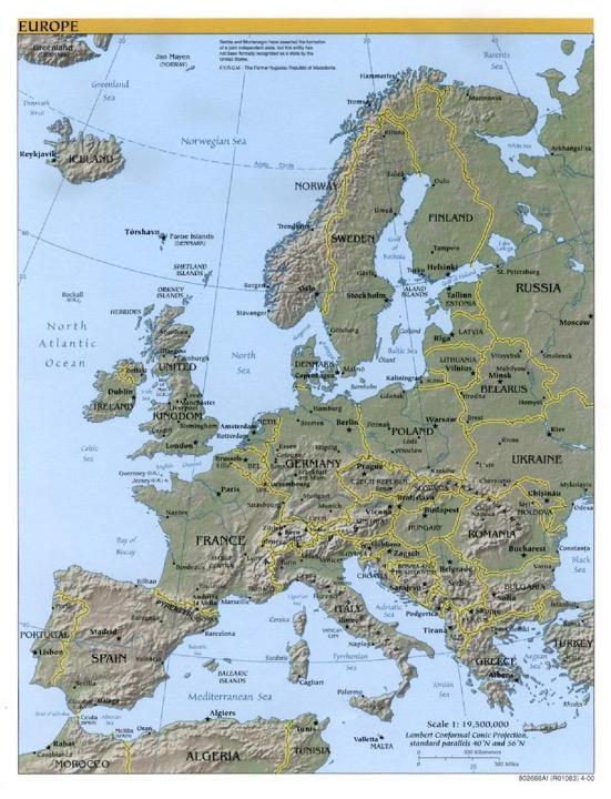
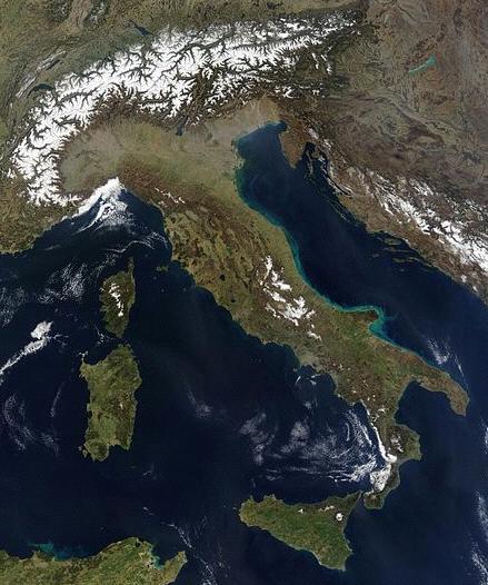
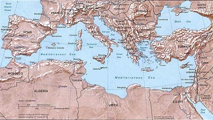
2 PENINSULA OF PENINSULAS Europe is a large peninsula that consists of many smaller peninsulas Most places in Europe are no more than 300 miles from an ocean or sea
3
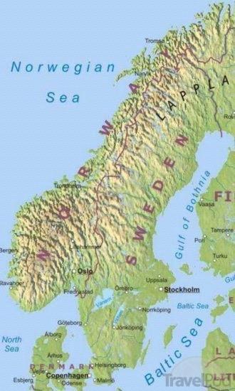
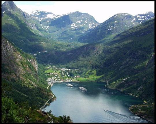
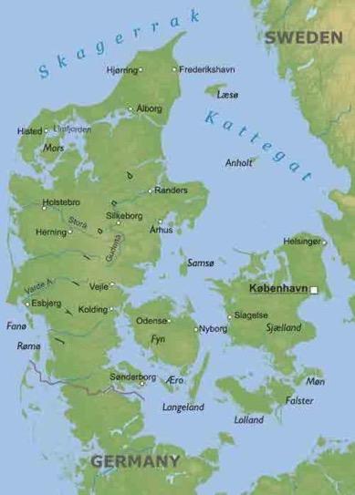
4 NORTHERN PENINSULAS The Scandinavian Peninsula is made up of Norway and Sweden and is bounded by the Norwegian, North, and Baltic Seas Glaciation created fjords steep U-shaped valleys that connect to the sea and that filled with seawater after the glaciers melted Countries of Northern Europe: Scandinavian Peninsula: Norway and Sweden Jutland Peninsula: Denmark Finland Island country of Iceland


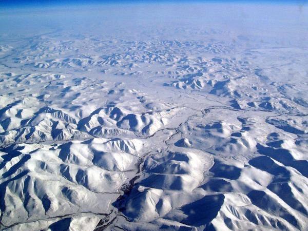
5 Northern Peninsula Svalbard is an archipelago of Norway in the Arctic Ocean Glaciers and snowfields cover more than 50% of the islands land Landforms were created through many ice ages and folding and faulting of continental drift and plate tectonics
6
7
8 NORTHERN PENINSULAS Iceland: contains abundant geothermal energy caused by tectonic activity and many rivers and waterfalls to produce hydropower numerous mountains, hot springs, and geysers Jutland Peninsula: consists of gently rolling hills and swampy low-lying areas which are different than the rocky land of the Scandinavian Peninsula Natural resources: Peat deposits (vegetable matter in swamps), iron ore, timber, hydroelectric power, oil and natural gas
9 Northwestern Europe Landscape of NW Europe consists of plains interrupted by mountains Northern European Plain has fertile soil and wealth of rivers with deposits of loess, sediment left by glaciers Alps mountain system are a high and jagged mountain range that runs from southern France through Switzerland and Austria to the Balkan Peninsula
10 Northwestern Europe Central Uplands (between the Alps and Northern European Plain): France, Belgium, Germany low rounded mountains, hills, and high plateaus with scattered forests British Isles: Great Britain, Ireland rugged coastline with rocky cliffs and deep bays
11
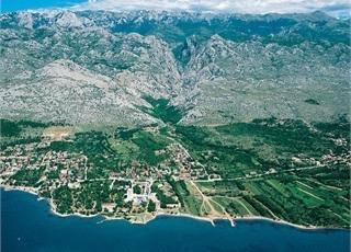
12 SOUTHERN PENINSULAS Iberian Peninsula is home to Spain and Portugal. Pyrenees Mountains block it off from the rest of Europe Italian Peninsula is home to Italy. It is shaped like a boot, extends into the Mediterranean Sea The Balkan Peninsula is bordered by the Adriatic, Mediterranean, and Aegean Seas. It s mountains make transportation difficult Natural Resources: copper, coal, tin, tungsten, hydroelectricity
13
14 Iberian Peninsula: Southern Europe Coastal plains give way to a large plateau, the Mesata Pryenees is characterized by flat topped massifs - body of mtn ranges formed by fault-line activity Italian Peninsula: Plains cover about one-third of the peninsula coastline varies from rocky cliffs to sandy beaches Apennine Mtns. run down the spine of the peninsula Balkan Peninsula: easy access to the sea with nearly 2,000 islands Greece is the southernmost country Some limited communication and development because of isolation from mountains and islands
15
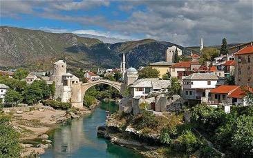
16 Eastern Europe Subregion is characterized by mountains and plains Lowlands within these mountainous areas are restricted to small plains and deltas - Dinaric Alps - spanning Slovenia, Croatia, Bosnia and Hezergovina, Macedonia, Albania, and Montenegro Karst topography, characterized by caves, sinkholes, underground rivers
17


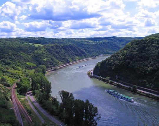
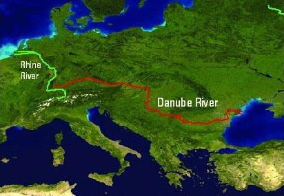
18 ISLANDS The larger islands are Great Britain, Ireland, Iceland, and Greenland all located in the North Atlantic The smaller islands are Corsica, Sardinia, Sicily, and Crete all located in the Mediterranean Sea
19
20
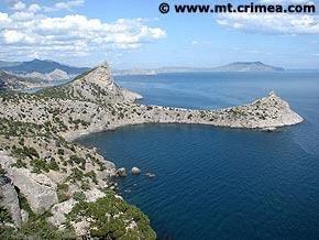
21 Russian Core Mountain ranges: Ural Mountains (separating Europe from Asia) and the Caucasus Mountains Majority of Russian population lives in the southern part of Russia navigable waterways and black fertile soil, chernozem, supporting agriculture Siberian Plain covers one-third of Siberia, known for its harsh continental climate and world s largest swamps and wetlands Ukraine occupies the Russian Plain with vast plains and plateaus Isthmus of Perekop connects Crimean Peninsula to mainland Natural Resources: timber, petroleum, coal, aluminum, gemstones, platinum, iron ore

22
23 MOUNTAINS The Alps cut Italy off from the rest of Europe just as the Pyrenees restrict movement from France to Spain and Portugal The Apennines divide the Italian Peninsula into east and west Balkans block off the Balkan Peninsula from the rest of Europe Resulted in the isolation of ethnic groups from each other

24 These are the Alps, which are the most famous mountain range in Europe
25 RIVERS Rivers are used to transport goods between coastal harbors and the inland region 2 major rivers: Danube and Rhine The Rhine flows from the interior to the North Sea while the Danube flows west to east through Europe touching 9 countries
26

27 The Volga River begins near Moscow and is the longest river on the European continent VOLGA RIVER
6.3 Geography. The student uses geographic tools to answer geographic questions. The student is expected to:
 Europe as a Region 1 6.3 Geography. The student uses geographic tools to answer geographic questions. The student is expected to: (A) pose and answer geographic questions, including: Where is it located?
Wednesday, November 15, 2017
 Wednesday, November 15, 2017 Northern Europe: Physical Geography Objective: Locate and describe the various traditional regions of Western Europe. Outline how the physical geography varies from region
What is the largest country in the world? Russia
 What is the largest country in the world? #1 Russia CSCOPE 2007 2 Russia Dimensions #2-3 Spans 11 Time Zones From East to West: Gulf of Finland to Alaska From North to South: Above the Arctic Circle to
The United States & Canada. A Regional Study of Anglo America
 A Regional Study of Anglo America Landform Regions of the United States & Canada world leaders in agricultural and industrial production because of... VAST LANDS stretch from the Atlantic Ocean on the
Explain the impact of location, climate, natural resources, and population distribution on Europe. a. Compare how the location, climate, and natural
 SS6G10 Explain the impact of location, climate, natural resources, and population distribution on Europe. a. Compare how the location, climate, and natural resources of Germany, the United Kingdom and
WHAT IS THE EARTH MADE OF? LITHOSPHERE AND HYDROSPHERE
 UNIT 8 WHAT IS THE EARTH MADE OF? LITHOSPHERE AND HYDROSPHERE TABLE OF CONTENTS 1 THE STRUCTURE OF THE EARTH... 2 2 THE FORMATION OF THE RELIEF: INTERNAL AND EXTERNAL FORCES.... 2 2.1 Internal forces:
Landscape evolution. An Anthropic landscape is the landscape modified by humans for their activities and life
 Landforms Landscape evolution A Natural landscape is the original landscape that exists before it is acted upon by human culture. An Anthropic landscape is the landscape modified by humans for their activities
September 14, 2013 Objective: How does geography impact history? What important features exist that have shaped societies?
 Lowenhaupt 1 September 14, 2013 Objective: How does geography impact history? What important features exist that have shaped societies? Warm-Up: In your binder, answer the following question: Imagine you
Chapter 6 Test Northern Europe 1
 Name Score Chapter 6 Test Northern Europe Part 1 Labeling A. (5 pts.) Locate the countries in the word box below on the map of Northern Europe on the next page. Write the name of the country in the correct
CANADA S LANDFORM REGIONS
 CANADA S LANDFORM REGIONS Canada s Regions Canada is divided into Eight major regions. A Region is an area that is defined on the basis of the presence or absence of certain characteristics: Age of rock
Physical Geography. Ariel view of the Amazon Rainforest. A Look at the Seven Continents
 Physical Geography In this unit you will learn about general physical geography. The study of the Earth s surface features provides the setting for the human-environmental interactions and for the human
2 Georgia: Its Heritage and Its Promise
 TERMS region, erosion, fault, elevation, Fall Line, aquifer, marsh, climate, weather, precipitation, drought, tornado, hurricane, wetland, estuary, barrier island, swamp PLACES Appalachian Mountains, Appalachian
Unit 1: Geography. For additional information, refer to this website: 1 G e o g r a p h y
 Unit 1: Geography For additional information, refer to this website: http://mryoungtms.weebly.com/ 1 G e o g r a p h y Continents and Oceans SOL USI. 2a Essential Understanding: Continents are large land
4th GRADE MINIMUM CONTENTS- SOCIAL SCIENCE UNIT 3: LAND RELIEF
 LAND RELIEF 4th GRADE MINIMUM CONTENTS- SOCIAL SCIENCE UNIT 3: LAND RELIEF The outer layer of the Earth is composed of rocks and minerals. It is called the lithosphere or the Earth s crust. This layer
PALEOGEOGRAPHY of NYS. Definitions GEOLOGIC PROCESSES. Faulting. Folding 9/6/2012. TOPOGRAPHIC RELIEF MAP of NYS GRADATIONAL TECTONIC
 TOPOGRAPHIC RELIEF MAP of NYS PALEOGEOGRAPHY of NYS Prof. Anthony Grande AFG 2012 Definitions GEOLOGIC PROCESSES Geography: study of people living on the surface of the earth. Geology: the scientific study
Terrain Units PALEOGEOGRAPHY: LANDFORM CREATION. Present Geology of NYS. Detailed Geologic Map of NYS
 NYS TOPOGRAPHY Why so? PALEOGEOGRAPHY: LANDFORM CREATION Prof. Anthony Grande AFG 014 Present Geology of NYS Detailed Geologic Map of NYS Generalized Geology Detailed Geology Hot links to the fold out
discussion of North America s physical features, including its landforms and bodies of
 Chapter 7 Natural Environments of North America Chapter 7 focuses on the natural environments of North America. The chapter opens with a discussion of North America s physical features, including its landforms
Unit 1: Basics of Geography Test Review
 Name Date Period Unit 1: Basics of Geography Test Review Directions: Reading the following sections and complete the questions, charts, and diagrams. Types of Maps Maps that have a particular theme are
UNIT 2 WARM UP. List the OCEANS. Bonus: Name the Largest LAKE on Earth
 UNIT 2 WARM UP List the OCEANS Bonus: Name the Largest LAKE on Earth Land Forms Land Mountain Hill Cliff Butte Mesa Plateau Cave Volcano Desert Plains Prairie Steppe Marsh Swamp Tundra Glacier Continent
Landforms in Canada. Canada is made up of three dis;nct types of landforms: Canadian Shield Highlands Lowlands
 Canada s Landforms What is a Landform? A landform is any physical feature of the Earth s surface having a characteris;c, recognizable shape, produced by natural causes. Landforms include major features
Module 10: Resources and Virginia Geology Topic 4 Content: Virginia Geology Notes
 Virginia is composed of a very diverse landscape that extends from the beaches and barrier islands all of the way to the highly elevated Appalachian Plateau. Geologists have discovered ancient shallow
Developed in Consultation with Florida Educators
 Developed in Consultation with Florida Educators Table of Contents Next Generation Sunshine State Standards Correlation Chart... 7 Benchmarks Chapter 1 The Practice of Science...................... 11
THE EARTH S RELIEF SOCIAL SCIENCES 1º ESO
 THE EARTH S RELIEF SOCIAL SCIENCES 1º ESO 1. THE STRUCTURE OF THE EARTH The Earth is divided into layers: The crust is the surface layer. It is a thin, solid layer made of rock. The Earth s crust has a
Chapter 6, Part Colonizers arriving in North America found extremely landscapes. It looked different to region showing great.
 Social Studies 9 Unit 1 Worksheet Chapter 6, Part 1. 1. Colonizers arriving in North America found extremely landscapes. It looked different to region showing great. 2. The Earth is years old and is composed
EQ: Discuss main geographic landforms of the U.S. & Canada and examine varied landforms in relation to their lifestyles.
 EQ: Discuss main geographic landforms of the U.S. & Canada and examine varied landforms in relation to their lifestyles. Places & Terms for Discussion Appalachian Mountains Great Plains Canadian Shield
Social Studies 9 UNIT 2 GEOGRAPHIC INFLUENCES ON IDENTITY: PLACE AND PEOPLE
 Social Studies 9 UNIT 2 GEOGRAPHIC INFLUENCES ON IDENTITY: PLACE AND PEOPLE The Structure of the Earth To understand the forces that create Canada's physical landscape we must understand the structure
Landform Regions of Canada
 Landform Regions of Canada The movement of the earth s plates, and the resulting folding, faulting, and volcanic activity, have combined with the forces of erosion and weathering to create a variety of
ORLD G EOGRAPHY BASIC. NotB oring. Inventive Exercises to Sharpen Skills and Raise Achievement. Imogene Forte & Marjorie Frank
 The BASIC NotB oring SERIES SOCIAL IP 402-0 STUDIES SKILLS MIDDLE GRADES ORLD G EOGRAPHY Inventive Exercises to Sharpen Skills and Raise Achievement Series Concept & Development by Imogene Forte & Marjorie
Understanding Projections
 GEOGRAPHY SKILLS 1 Understanding Projections The earth is a sphere and is best shown as a globe. For books and posters, though, the earth has to be represented as a flat object. To do this, mapmakers create
Iceland. 1. Warm up. A. Talk about the picture and read the essay. B. Discuss the questions about the essay.
 1. Warm up A. Talk about the picture and read the essay. Iceland My country, Iceland, is one of the most beautiful countries on Earth. It is an island country. It is located in Europe, in the North Atlantic
Chapter 1: The Geography of the Western Hemisphere
 Chapter 1: The Geography of the Western Hemisphere Chapter 1, Lesson 1: The Changing Earth Objectives: - You will be able to identify the major natural events that cause the earth to change. - You will
netw rks Guided Reading Activity Essential Question: How does geography influence the way people live? Earth's Physical Geography
 Guided Reading Activity Lesson 1 Earth and the Sun Essential Question: How does geography influence the way people live? Looking at Earth Directions: What are the layers that make up Earth? Use your textbook
The structure of the Earth and how its motion creates the seasons. The landforms of the earth and the forces that shape the land.
 The structure of the Earth and how its motion creates the seasons. The landforms of the earth and the forces that shape the land. The role of wind and water in creating climate. The different climate and
Unit 2. United States Physical Geography
 Unit 2 United States Physical Geography Physical Geography U.S. extends from the Atlantic to Pacific U.S. is the 3rd largest country U.S. has fertile soils, vast forests, and variety of minerals All major
AP Environmental Science. Earth Systems: Part 3
 AP Environmental Science Earth Systems: Part 3 River Deep, Mountain High Geomorphology-the scientific study of landforms and the processes that shape them Water, water everywhere.. Oceans Arctic Ocean
2008 SIVECO Romania. All Rights Reserved. Geography. AeL econtent Catalogue
 2008 SIVECO Romania. All Rights Reserved. Geography AeL econtent Catalogue The Earth's Movements Recommended for two hours of teaching. AeL Code: 352. 2. The Earth Rotation Movement in 24 hours 3. The
Introduction. Table 27. Median concentrations of Eu in the FOREGS samples and in some reference data sets.
 Eu Europium Introduction See section on Rare Earth Elements (REEs). Table 27 compares the median concentrations of Eu in the FOREGS samples and in some reference datasets. Table 27. Median concentrations
What is a landform? These shapes (except for bodies of water) on the earth s surface are all examples of landforms.
 on the earth s surface are all examples of landforms.") Landforms What is a landform? These shapes (except for bodies of water) on the earth s surface are all examples of landforms. archipelago a large group of many islands. The Hawaiian Islands Lighthouse
Landforms What is a landform? These shapes (except for bodies of water) on the earth s surface are all examples of landforms. archipelago a large group of many islands. The Hawaiian Islands Lighthouse
Crop monitoring in Europe
 r Online version Issued: 21 February 2014 Crop monitoring in Europe MARS Bulletin Vol. 22 No. 2 (2014) Exceptional mild winter and very wet in western Europe Between January and February, persistent and
Crop monitoring in Europe
 r Online version Issued: 14 December 2015 Crop monitoring in Europe MARS Bulletin Vol. 23 No. 12 (2015) Mild weather favoured crop establishment but increased risk of frost damage Temperatures since the
What landforms make up Australia?!
 What landforms make up Australia? The tectonic forces of folding, faulting and volcanic activity have created many of Australia's major landforms. Other forces that work on the surface of Australia, and
Which landscape best represents the shape of the valleys occupied by glaciers? A) B) C) D)
 B) C) D)") 1. Glaciers often form parallel scratches and grooves in bedrock because glaciers A) deposit sediment in unsorted piles B) deposit rounded sand in V-shaped valleys C) continually melt and refreeze D) drag
1. Glaciers often form parallel scratches and grooves in bedrock because glaciers A) deposit sediment in unsorted piles B) deposit rounded sand in V-shaped valleys C) continually melt and refreeze D) drag
Grade 9 Social Studies Canadian Identity. Chapter 2 Review Canada s Physical Landscape
 Grade 9 Social Studies Canadian Identity Chapter 2 Review Canada s Physical Landscape Name: Unit 1: Empowerment Terms (notes or textbook) 1. Core 2. Crust 3. Mantle 4. Magma 5. Continental drift 6. Plate
Physical Geography. Physical Geography. Physical Landscape I of the United States and Canada. Definitions. Physical Geography GEOLOGIC PROCESSES
 Physical Landscape I of the United States and Canada Physical Geography Physical landscape (natural environment) sets the stage for human use (the cultural landscape). Prof. Anthony Grande AFG 2016 Landforms
MR. JOHNSON S. Geography OHIO COUNTY MIDDLE SCHOOL
 MR. JOHNSON S Geography OHIO COUNTY MIDDLE SCHOOL CHAPTER 1 Geography The science of geography is likely the oldest of all sciences. Geography is the answer to the question that the earliest humans asked,
What type of land feature is located at Point A? A Cliff B Delta C Mountain D Valley
 1 What type of land feature is located at Point A? A Cliff B Delta C Mountain D Valley Alfred Wegener s theory of continental drift was 2 not accepted by scientists when the theory was first proposed.
Chapter 1 Section 2. Land, Water, and Climate
 Chapter 1 Section 2 Land, Water, and Climate Vocabulary 1. Landforms- natural features of the Earth s land surface 2. Elevation- height above sea level 3. Relief- changes in height 4. Core- most inner
(version 3) I. HumAN -Environment Interaction
 I. HumAN -Environment Interaction") (version 3) I. HumAN -Environment Interaction A. Landforms 1. Earth s topography is made up of many different types of landforms. 2. While the planet is covered primarily with water, the four major types
(version 3) I. HumAN -Environment Interaction A. Landforms 1. Earth s topography is made up of many different types of landforms. 2. While the planet is covered primarily with water, the four major types
Leo Junikka & Pertti Uotila. Comparison of the vascular flora of the Mediterranean Peninsulas on the basis of distribution mapping.
 Leo Junikka & Pertti Uotila Comparison of the vascular flora of the Mediterranean Peninsulas on the basis of distribution mapping Abstract Junikka, L. & Uotila, P. 2002: Comparison of the vascular flora
Changes in Texas Ecoregions
 Comment On Lesson Changes in Texas Ecoregions The state of Texas can be divided into 10 distinct areas based on unique combinations of vegetation, topography, landforms, wildlife, soil, rock, climate,
Earth s Layers. Earth s Surface
 CHAPTER 1 LESSON 3 Earth s Layers Earth s Surface Key Concepts What are Earth s major landforms and how do they compare? What are the major landform regions of the United States? What do you think? Read
AD HOC DRAFTING GROUP ON TRANSNATIONAL ORGANISED CRIME (PC-GR-COT) STATUS OF RATIFICATIONS BY COUNCIL OF EUROPE MEMBER STATES
 STATUS OF RATIFICATIONS BY COUNCIL OF EUROPE MEMBER STATES") Strasbourg, 29 May 2015 PC-GR-COT (2013) 2 EN_Rev AD HOC DRAFTING GROUP ON TRANSNATIONAL ORGANISED CRIME (PC-GR-COT) STATUS OF RATIFICATIONS BY COUNCIL OF EUROPE MEMBER STATES TO THE UNITED NATIONS CONVENTION
Strasbourg, 29 May 2015 PC-GR-COT (2013) 2 EN_Rev AD HOC DRAFTING GROUP ON TRANSNATIONAL ORGANISED CRIME (PC-GR-COT) STATUS OF RATIFICATIONS BY COUNCIL OF EUROPE MEMBER STATES TO THE UNITED NATIONS CONVENTION
LANDFORM REGIONS IN CANADA. Classroom Notes and Descriptions
 LANDFORM REGIONS IN CANADA Classroom Notes and Descriptions Landform Regions in Canada There are eight distinct landforms in Canada: Western Cordillera Region Interior Plains Canadian Shield Hudson Bay
Unit 1: Geography GeoTrekkers in the Western Hemisphere. Illustrated Glossary
 Unit 1: Geography GeoTrekkers in the Western Hemisphere Illustrated Glossary adapt to change in order to fit new condi/ons archipelago a group or chain of islands clustered together in a sea or ocean bodies
Physical Geography of the United States and Canada Chapter 5 A Land of Contrasts
 Physical Geography of the United States and Canada Chapter 5 A Land of Contrasts Land Area Together the U.S. and Canada cover more than 7 million square miles. In total area, Canada ranks 2 nd and the
CHAPTER 1. Geo Challenges 1A to 1D. & World Map Activity
 CHAPTER 1 Geo Challenges 1A to 1D & World Map Activity SELECT YOUR CHALLENGE World Map Activity Challenge 1A Challenge 1B Challenge 1C Challenge 1D Challenge 1A WS PG. 2 STEP #1 Label the largest continent
Physical Geography. Physical Landscape I of the United States and Canada. Definitions. Physical Geography. Physical Geography GEOLOGIC PROCESSES
 Physical Landscape I of the United States and Canada Prof. Anthony Grande AFG 2017 Physical Geography Landforms and geologic processes Physical landscape (natural environment) sets the stage for human
Sample. Our Earth RED4001. Earth Science themes for 9 12 year olds. ISBN
 RED4001 Our Earth Earth Science themes for 9 12 year olds. Written by Judy Gabrovec. Illustrated by Melinda Parker. Typesetting and Design by Shay Howard. Published by Ready-Ed Publications (2006) Ready-Ed
Teacher Guide. Our resource has been created for ease of use by both TEACHERS and STUDENTS alike. Sample file NAME: A on Mount Olympus, Greece
 Introduction his resource provides ready-to-use information and activities for remedial students in grades five to eight. Written to grade and using simplified language and vocabulary, geography concepts
core mantle crust the center of the Earth the middle layer of the Earth made up of molten (melted) rock
 rock") core the center of the Earth mantle the middle layer of the Earth made up of molten (melted) rock crust the surface layer of the Earth that includes the continents and oceans 1 continental drift the theory
core the center of the Earth mantle the middle layer of the Earth made up of molten (melted) rock crust the surface layer of the Earth that includes the continents and oceans 1 continental drift the theory
South, Southeast, and East Asia. Physical Geography
 South, Southeast, and East Asia Physical Geography Mountains v Mountains are important in Asia because they influence: A. Population patterns B. Movement of people and goods C. Climate Mountains v The
4 th Grade Virginia Studies SOL Review Packet Geography of Virginia. 1. The Algonquian language group of Indians lived in what region of Virginia?
 4 th Grade Virginia Studies SOL Review Packet Geography of Virginia 1. The Algonquian language group of Indians lived in what region of Virginia? A. Allegheny B. Piedmont C. Ridge and Valley D. Tidewater
Static GK. World Geography. innovation. Assignment 01
 Static GK World Geography innovation Assignment 01 World Geography Practice Assignment 01 Direction for question 1-35: Mark the best option. 1. Which strait separates Europe from Africa? A) Mallaica B)
Social Studies. Chapter 2 Canada s Physical Landscape
 Social Studies Chapter 2 Canada s Physical Landscape Introduction Canada s geography its landforms and climate - has a great impact on Canadians sense of identity. Planet Earth The earth is divided into
Topography of the conterminous United States
 Topography of the conterminous United States Potential Natural Vegetation Geology Coastal Ranges physiographic province Cascade-Sierra Mountains Cascades Mount Hood California central valley Sierra-Nevada
Chapter 21 Southwest Asia: Harsh & Arid Lands
 Name Hour Chapter 21 Southwest Asia: Harsh & Arid Lands Essential Question: How has the physical geography of Asia influenced the development of these regions (i.e. history, population distribution, &
Chapter 1: America s Land Lesson 1: Land and Climate
 Chapter 1: America s Land Lesson 1: Land and Climate Geography: Describe landforms and other physical features of the United States. Geography: Explain how and why climate varies throughout the United
Exploring Geography. Chapter 1
 Exploring Geography Chapter 1 The Study of Geography Geography is the study of where people, places, and things are located and how they relate to each other. Greek meaning writing about or describing
Sample file. Permission is granted to backup and store the audio tracks on a CD disk.
 Congratulations on the purchase of this electronic ebook. This ebook purchase includes extra media files. When the text in this ebook references a CD track or transparency page, please refer to the extra
Physical Geography of East Asia
 Physical Geography of East Asia Satellite View of China Landforms of China China s Geography China Miles 0 250 500 1,000 1,500 2,000 United States 3 rd largest country in the world. Comparable to the US
Mammoth Cave National Park, Kentucky
 Mammoth Cave National Park, Kentucky Objectives of Today s Lecture Refresher on Sedimentary Depositional Systems and Rock Classifications Transgressive and Regressive Marine Environments Carbonate Depositional
Europe, Canada, Latin America, & Australia
 Europe, Canada, Latin America, & Australia EUROPE SS6G8 The student will locate selected features of Europe. a. Locate on a world and regional political- physical map: the Danube River, Rhine River, English
e Southeast Region of the United Statesg
 e Southeast of the United Statesg - relative location: the location of a place in relation to another place (i.e. south, near, bordering, next to) - barrier islands: located off the southeast coast of
JRC MARS Bulletin Crop monitoring in Europe January 2019
 Online version Issued: 21 January 2019 r JRC MARS Bulletin Vol. 27 No 1 JRC MARS Bulletin Crop monitoring in Europe January 2019 Continued mild winter Improved hardening of winter cereals in central and
Erosion and Deposition
 Erosion and Deposition Erosion Sediment natural forces move rock/soil from one place to another. gravity, water, wind, glaciers, waves are causes material moved by erosion Deposition when erosion lays
Physical Geography A Living Planet
 Physical Geography A Living Planet The geography and structure of the earth are continually being changed by internal forces, like plate tectonics, and external forces, like the weather. Iguaçu Falls at
Canada is a country with diverse physical features.
 Chapter 3 Landforms Canada is a country with diverse physical features. With one of the longest coastlines in the world one can discover a variety of coastal features: bays, gulf, islands, peninsulas,
UNIT 3: THE CONTINENTS
 UNIT 3: THE CONTINENTS TOPICS 1. The continents 2. Europe 3. Africa 4. America 5. Asia 6. Oceania 7. Antarctica 8. Relief of Spain 1. The continents The Earth consist of six continents: Europe, Africa,
SAMPLE. Succeeding in Social Studies 3 4 TH IN A SERIES OF 7. Years 3 4. Written by Valerie Marett. CORONEOS PUBLICATIONS Item No 506
 AUSTRALIAN HOMESCHOOLING SERIES Succeeding in Social Studies 3 4 TH IN A SERIES OF 7 Years 3 4 Written by Valerie Marett CORONEOS PUBLICATIONS Item No 506 Contents Notes to Parents......2 Maps...... 3
JRC MARS Bulletin Crop monitoring in Europe December 2018
 Online version Issued: 17 December r JRC MARS Bulletin Vol 26 No 12 JRC MARS Bulletin Crop monitoring in Europe December 2018 Mild start of winter Colder conditions forecast expected to improve frost tolerance
4th Grade U.S. Regional Geography
 4th Grade U.S. Regional Geography Multiple Choice Identify the choice that best completes the statement or answers the question. What does the term mainland mean in the sentence above? A the continent
All of Virginia's 4 main rivers flow into the... Chesapeake Bay. Along which river would Jamestown be found? James River. Appalachian Mountains
 All of Virginia's 4 main rivers flow into the... Along which river would Jamestown be found? The Blue Ridge Mountains and Valley and Ridge are part of what large mountain system? Define climate. Define
Tropical Moist Rainforest
 Tropical or Lowlatitude Climates: Controlled by equatorial tropical air masses Tropical Moist Rainforest Rainfall is heavy in all months - more than 250 cm. (100 in.). Common temperatures of 27 C (80 F)
JRC MARS Bulletin Crop monitoring in Europe. February 2018 Frost tolerance remains weak. Winter conditions so far present no threat to winter crops
 JRC MARS Bulletin Vol. 26 No 2 Period covered: 1 January 2018-13 February 2018 Issued: 19 February 2018 JRC MARS Bulletin Crop monitoring in Europe February 2018 Frost tolerance remains weak Winter conditions
Australia and New Zealand: Powerpoint
 Australia and New Zealand: Powerpoint Physical Geography Australia and New Zealand are between the Indian and Pacific Oceans. Australia s seasons are opposite of the United States due to their location.
Geology is the study of the structure and substance of the earth. The earth s physical features have been created by many geological events:
 UNIT 1 NOTES : GEOLOGY & THE EARTH S PHYSICAL STRUCTURE GEOLOGY & THE EARTH S PHYSICAL STRUCTURE Geology is the study of the structure and substance of the earth. The earth s physical features have been
Crop Monitoring in Europe WINTER CEREAL HARDENING IS PROGRESSING WELL. MARS BULLETIN Vol.20 No.12 (2012)
") ONLINE VERSION JRC68576 EUR 24736 EN ISSN 1831-9424 ISSN 1831-9793 Crop Monitoring in Europe MARS BULLETIN Vol.20 No.12 (2012) Issued: 17 December 2012 WINTER CEREAL HARDENING IS PROGRESSING WELL The last
ONLINE VERSION JRC68576 EUR 24736 EN ISSN 1831-9424 ISSN 1831-9793 Crop Monitoring in Europe MARS BULLETIN Vol.20 No.12 (2012) Issued: 17 December 2012 WINTER CEREAL HARDENING IS PROGRESSING WELL The last
Your web browser (Safari 7) is out of date. For more security, comfort and the best experience on this site: Update your browser Ignore
 is out of date. For more security, comfort and the best experience on this site: Update your browser Ignore") Your web browser (Safari 7) is out of date. For more security, comfort and the best experience on this site: Update your browser Ignore DOGGERL AND - THE EU RO PE THAT WAS The British Isles were once neither
Your web browser (Safari 7) is out of date. For more security, comfort and the best experience on this site: Update your browser Ignore DOGGERL AND - THE EU RO PE THAT WAS The British Isles were once neither
PART II. Physical Landscape Chapters 2 5
 PART II Physical Landscape Chapters 2 5 Prof. Anthony Grande 2016 Lecture design, content and presentation AFG 0616. Individual images and illustrations may be subject to prior copyright. R E M I N D E
Landforms and Bodies of Water
 Chapter 5, Section 1 For use with textbook pages 115 120. The Land Terms to Know divide A high point or ridge that determines the direction that rivers flow (page 118) headwaters The source waters of a
PHYSICAL GEOGRAPHY General Information
 PHYSICAL GEOGRAPHY General Information By understanding the environment we can understand why one place is different or the same as another. See handout Geomorphology Geo --Land morph --Change ology --Study
Terms, People, and Places. Five Themes of Geography: Three Kinds of Maps: Natural Resources: Land Terms: Water Terms:
 Terms, People, and Places Five Themes of Geography: Three Kinds of Maps: Natural Resources: Land Terms: Water Terms: Lesson Objectives Explain how geography impacts human development Analyze how human
IR-17: Cause and Effect Reading to Learn
 IR-17: Cause and Effect Reading to Learn Define the following terms: land hemisphere island peninsula isthmus continental drift fault subduction Ring of Fire soil 2013 Region 4 Education Service Center
Vocabulary Words. theory continental drift fault magma lava. weathering glacier erosion deposition delta
 Earth s Landforms Vocabulary Words theory continental drift fault magma lava weathering glacier erosion deposition delta Theory: A possible explanation. Continental drift: The continuing movement of the
Terms. divide headwaters tributary fall line fishery
 Chapter 5 Preview Section 1 The Land Objectives Identify some key similarities and differences in the physical geography of the United States and Canada. Explain why rivers have played such an important
World Industrial Regions
 World Industrial Regions North America Industrialized areas in North America Changing distribution of U.S. manufacturing Europe Western Europe Eastern Europe East Asia Manufacturing Regions Fig. 11-3:
Geography Definitions/Sentences
 Geography Definitions/Sentences 1. BEACH 1. The shore of a body of water, especially when sandy or pebbly. 2. The sand or pebbles on a shore. The zone above the water line at a shore of a body of water,
Map List. 560 World World Physical World Physical-Pacific & Atlantic Region World Landforms World Ocean Floor 10
 Map List CategoryName Map# MapName Thumb nail Page # 560 World 2 561 World Physical 4 562 World Physical-Pacific & Atlantic Region 6 563 World Landforms 8 564 World Ocean Floor 10 565 North Polar Region
4. The map below shows a meandering stream. Points A, B, C, and D represent locations along the stream bottom.
 1. Sediment is deposited as a river enters a lake because the A) velocity of the river decreases B) force of gravity decreases C) volume of water increases D) slope of the river increases 2. Which diagram