CLIMATE AND LAND USE DRIVERS OF MALARIA RISK IN THE PERUVIAN AMAZON,
|
|
|
- Kristian Briggs
- 6 years ago
- Views:
Transcription

1 CLIMATE AND LAND USE DRIVERS OF MALARIA RISK IN THE PERUVIAN AMAZON, Ben Zaitchik Johns Hopkins University Beth Feingold, Denis Valle, Alex Sandoval, Carlos Alvarez Antonio, Rosa Patricia Zegarra Vasquez, and William Pan


 appear ~5 10 days after being bitten")
2 Anopheles darlingi is the dominant malaria vector in the Peruvian Amazon Biting rates are influenced by both climate and land cover Symptoms (e.g., fever, chills, etc.) appear ~5 10 days after being bitten by an infected mosquito.
3 THE PERUVIAN AMAZON Over 90% of malaria in the Western Hemisphere is located in the Amazon In Peru, 75% of malaria cases occur in the Department of Loreto. 80% of these cases occur in just 10 of the department's 51 districts. Key factors related to continued malaria endemicity: expansion of vector habitats from deforestation: logging and road development) social and ecological processes that increase human exposure Anopheles darlingi


4 MALARIA IN PERU, 2012 P. vivax P. falciparum Iquitos Lima Puerto Maldonado

5 THE PERUVIAN AMAZON The total number of confirmed Malaria cases in the Amazon declined by 43% between 2000 and 2009 However, there has been evidence of a resurgence in the past three years Climate variability may play a role in the recent increase
6 # Cases (1000s) Reported Malaria, Loreto Province P. vivax P. falciparum MAJOR FLOOD * Highest Deforestation Rate in Peru Iquitos-Nauta Road Paving & Fujimori logging concessions Roll Back Malaria 2 nd highest increase in the Amazon to 2006, Major decline to 2011
7 AIMS 1. Model and predict the distribution of malaria vectors Anopheles mosquitoes as a function of land cover and hydrometeorology. 2. Model and predict transmission risk as a function of hydrometeorology, land cover, and human activities.
8 ANALYTIC FRAMEWORK LAND COVER & LAND COVER CHANGE VECTOR DISTRIBUTION MALARIA CASES CLIMATE HYDROLOGY PREDICTIVE MODEL
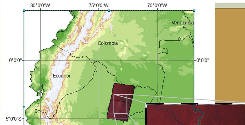
9 ANALYTIC FRAMEWORK: VECTORS Iquitos
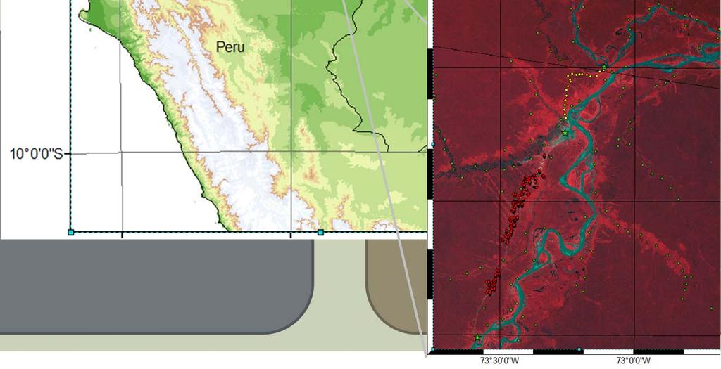
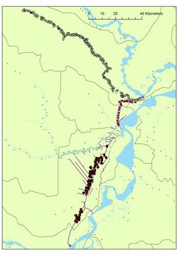
10 ANALYTIC FRAMEWORK: VECTORS LOCAL LAND COVER Landsat-based Land Cover Maps Forest change evaluated at 5 year intervals 1KM RESOLUTION LAND DATA ASSIMILATION SYSTEM TRMM precipitation MODIS-derived land characteristics LARVA AND ADULT MOSQUITOES > 3000 collection sites over two years Typed by species VECTOR DISTRIBUTION HIERARCHICAL BAYESIAN MODELS Number of water bodies Larva for each species Adults for each species
11 ANALYTIC FRAMEWORK: TRANSMISSION RISK
12 ANALYTIC FRAMEWORK: TRANSMISSION RISK REGIONAL LAND COVER MODIS Land Cover, GVF, and phenology NatureServe Ecological Systems 5KM RESOLUTION LAND DATA ASSIMILATION SYSTEM TRMM precipitation MODIS-derived land characteristics HEALTHPOST CASE REPORTS > 300 healthposts for 12 years in 51 districts P. vivax and P. falciparum POISSON RANDOM EFFECTS MODEL Weekly case counts Vivax and falciparum RISK


13 GENERATING INPUTS: LAND COVER MCD12Q1 captures variability within the Amazon Forest Phenology-based classifications based on 16-day MODIS 250m NDVI product offer complementary information NatureServe sistemas ecologicos capture complementary and additional information NatureServe Mountain forest High hills forest Terrace forest Central wetlands Northern evrgn. forest Slope forest Rivers and river banks
14 GENERATING INPUTS: LDAS A Land Data Assimilation System (LDAS) is a computational tool that merges observations with numerical models to produce optimal estimates of land surface states and fluxes.


15 GENERATING INPUTS: LDAS Landscape Information Update Observations LDAS Output Numerical Model Meteorological Data Hydrological fluxes and storage Localized meteorology Surface energy balance

16 GENERATING INPUTS: LDAS TMPA + GDAS forcing is effective MODIS GVF and Land Cover add spatial structure Noah LSM simulations show significant spatial and temporal variability Resolution and quality of soil maps should be improved Evaluation data are limited Data Assimilation has had a marginal effect
17 VECTORS: SPATIALLY-EXPLICIT ANOPHELES MODEL Water bodies Model 1: water bodies Water bodies with larva from species i Water bodies with larva from species j Water bodies with larva from species k Model 2: larva Adult mosquito abundance from species i Adult mosquito abundance from species j Adult mosquito abundance from species k Model 3: adult mosq. Malaria infection Model 4: infection
18 RESULTS: VECTOR MODEL Water Bodies: T min [5 day] Rain [1 day] SW net [1 day] SW net [5 day] Soil Moisture [5 day]
19 Larva: Forest Cover RESULTS: VECTOR MODEL
20 RESULTS: VECTOR MODEL Larva: Hydrometeorology

21 RESULTS: VECTOR MODEL Adults: Impervious Area Anopheles darlingi
22 TRANSMISSION RISK: MULTILEVEL SPATIAL POISSON MODEL Goal: a predictive model operating on the district (n=51) scale Weekly malaria case data (vivax and falciperum) is drawn from all health posts (n=356) for The model considers land cover, population distribution (c. 2007), malaria trends, and weekly meteorological and hydrological conditions over multiple lag times In contrast to previous predictive efforts, we aim to distinguish trends from seasonality The model informs both forecasts and understanding
23 TRANSMISSION RISK: MULTILEVEL SPATIAL POISSON MODEL Model for each district: MALARIA RATE (t) = Annual TREND SEASONAL Cycles CLIMATE Drivers LAND COVER Characteristics
24 TRANSMISSION RISK: MULTILEVEL SPATIAL POISSON MODEL Model for each district: MALARIA RATE (t) = Annual TREND SEASONAL Cycles CLIMATE Drivers LAND COVER Characteristics Captures the long-term change in the mean of malaria cases in the district Variation in the series that is annual in period. It is of direct interest (i.e., we do not remove seasonality, but rather estimate it) Influence both human exposure (e.g., occupational labor) and Anopheles density

25 RESULTS: MALARIA TRANSMISSION MODEL Preliminary analysis: (earlier version of Poisson model) Vivax Significant climate predictors include soil moisture and rainfall. Temperature predictors are not, at present, significant. Forest type is a significant predictor, as is the nature of inundation patterns. Model fit scores are high (AIC), but over-dispersion exists, likely due to spatial correlation. Falciparum
26 CONCLUSIONS & NEXT STEPS Satellite-derived land cover and meteorology can drive skillful models of vectors and inform models of malaria risk. Land Surface Models increase the predictive value of satellite observations. Mosquito species respond differently to land cover change but similarly to hydrometeorology. Satellite-derived precipitation and simulated soil moisture both inform predictions of transmission risk. Refine malaria transmission model using data and being applied to hindcasts of Work with health officials to operationalize the models.
27 THANK YOU
EPIDEMIOLOGY FOR URBAN MALARIA MAPPING
 TELE-EPIDEMIOLOGY EPIDEMIOLOGY FOR URBAN MALARIA MAPPING @IRD/M Dukhan Vanessa Machault Observatoire Midi-Pyrénées, Laboratoire d Aérologie Pleiades days 17/01/2012 The concept of Tele-epidemiology The
Predicting Malaria Epidemics in Ethiopia
 Predicting Malaria Epidemics in Ethiopia Eskindir Loha, Hawassa University Torleif Markussen Lunde, UoB 5th Conference on Global Health and Vaccination Research: Environmental Change and Global Health
Vector Hazard Report: Malaria in Ghana Part 1: Climate, Demographics and Disease Risk Maps
 Vector Hazard Report: Malaria in Ghana Part 1: Climate, Demographics and Disease Risk Maps Information gathered from products of The Walter Reed Biosystematics Unit (WRBU) VectorMap Systematic Catalogue
TELE-EPIDEMIOLOGY URBAN MALARIA MAPPING
 TELE-EPIDEMIOLOGY URBAN MALARIA MAPPING Ministère de la Défense Vanessa Machault Advances in Geospatial Technologies for Health 12-13/09/2011 Objective To develop a robust pre-operational methodology to
Quenching the Valley s thirst: The connection between Sierra Nevada snowpack & regional water supply
 Quenching the Valley s thirst: The connection between Sierra Nevada snowpack & regional water supply Roger Bales, UC Merced Snow conditions Snow & climate change Research directions Sierra Nevada snow
USING REMOTE SENSING AND MODELING TECHNIQUES TO INVESTIGATE MALARIA PREVALENCE IN LORETO, PERU
 USING REMOTE SENSING AND MODELING TECHNIQUES TO INVESTIGATE MALARIA PREVALENCE IN LORETO, PERU Committee: by Aneela Mousam A Thesis Submitted to the Graduate Faculty Of George Mason University in Partial
Director: Soroosh Sorooshian
 Director: Soroosh Sorooshian X. Gao B. Imam K. Hsu S. O Rourke D. Hohnbaum J. Li G.H. Park D. Braithwaite E. Pritchard B. Khakbaz W. Chu A. Behrangi Alex R. Sutlana Joey A. Zahraei Developing state-of-the-art
Understanding the hydrology of the large wetlands of the Bolivian Amazon using remote sensing and hydrological modeling
 Understanding the hydrology of the large wetlands of the Bolivian Amazon using remote sensing and hydrological modeling Preliminary results 6 th SO HYBAM Scientific Meeting Cusco, Octubre 2015 Alex Ovando
Flood Forecasting Tools for Ungauged Streams in Alberta: Status and Lessons from the Flood of 2013
 Flood Forecasting Tools for Ungauged Streams in Alberta: Status and Lessons from the Flood of 2013 John Pomeroy, Xing Fang, Kevin Shook, Tom Brown Centre for Hydrology, University of Saskatchewan, Saskatoon
The Response of Environmental Capacity for Malaria Transmission in West Africa to Climate Change
 AGU Fall Meeting December 9, 2011 The Response of Environmental Capacity for Malaria Transmission in West Africa to Climate Change Teresa K. Yamana & Elfatih A.B. Eltahir MIT Dept. of Civil & Environmental
CGMS-45-WMO-WP-05 Monitoring Extreme Weather and Climate from Space. World Meteorological Organization (WMO) Space Programme
 Space Programme") CGMS-45-WMO-WP-05 Monitoring Extreme Weather and Climate from Space World Meteorological Organization (WMO) Space Programme Introduction UNOSAT Report Satellite Detected Waters over Xieng Ngneun District,
CGMS-45-WMO-WP-05 Monitoring Extreme Weather and Climate from Space World Meteorological Organization (WMO) Space Programme Introduction UNOSAT Report Satellite Detected Waters over Xieng Ngneun District,
Seasonal and interannual relations between precipitation, soil moisture and vegetation in the North American monsoon region
 Seasonal and interannual relations between precipitation, soil moisture and vegetation in the North American monsoon region Luis A. Mendez-Barroso 1, Enrique R. Vivoni 1, Christopher J. Watts 2 and Julio
Space-based Weather and Climate Extremes Monitoring (SWCEM) Toshiyuki Kurino WMO Space Programme IPET-SUP-3, 2-4 May 2017
 Toshiyuki Kurino WMO Space Programme IPET-SUP-3, 2-4 May 2017") Space-based Weather and Climate Extremes Monitoring (SWCEM) Toshiyuki Kurino WMO Space Programme IPET-SUP-3, 2-4 May 2017 based on outcome from Workshop on Operational SWCEM 15-17 February 2017, Geneva
Space-based Weather and Climate Extremes Monitoring (SWCEM) Toshiyuki Kurino WMO Space Programme IPET-SUP-3, 2-4 May 2017 based on outcome from Workshop on Operational SWCEM 15-17 February 2017, Geneva
Tropical Montane Cloud Forests: Importance and Challenges in a Changing Environment
 Tropical Montane Cloud Forests: Importance and Challenges in a Changing Environment Daniel E. Comarazamy and Jorge E. González The NOAA-CREST Center & Department of Mechanical Engineering, City College
Greening of Arctic: Knowledge and Uncertainties
 Greening of Arctic: Knowledge and Uncertainties Jiong Jia, Hesong Wang Chinese Academy of Science jiong@tea.ac.cn Howie Epstein Skip Walker Moscow, January 28, 2008 Global Warming and Its Impact IMPACTS
Stochastic Hydrology. a) Data Mining for Evolution of Association Rules for Droughts and Floods in India using Climate Inputs
 Data Mining for Evolution of Association Rules for Droughts and Floods in India using Climate Inputs") Stochastic Hydrology a) Data Mining for Evolution of Association Rules for Droughts and Floods in India using Climate Inputs An accurate prediction of extreme rainfall events can significantly aid in policy
Stochastic Hydrology a) Data Mining for Evolution of Association Rules for Droughts and Floods in India using Climate Inputs An accurate prediction of extreme rainfall events can significantly aid in policy
Satellite observed sensitivity of malaria to ENSO and AVHRR based vegetation health for short and long term forecasting in Bangladesh and India By
 Satellite observed sensitivity of malaria to ENSO and AVHRR based vegetation health for short and long term forecasting in Bangladesh and India By Leonid Roytman*, Mohammad Nizamuddin*, Mitch Goldberg**
Introduction to ecosystem modelling (continued)
") NGEN02 Ecosystem Modelling 2015 Introduction to ecosystem modelling (continued) Uses of models in science and research System dynamics modelling The modelling process Recommended reading: Smith & Smith
NGEN02 Ecosystem Modelling 2015 Introduction to ecosystem modelling (continued) Uses of models in science and research System dynamics modelling The modelling process Recommended reading: Smith & Smith
The Spatiotemporal Relationship between Climate and Valley Fever in the Southwestern United States
 The Spatiotemporal Relationship between Climate and Valley Fever in the Southwestern United States 9/27/2016 - Phoenix, AZ, courtesy of KPHO/KTVK Morgan Gorris 1, Linh Anh Cat 2, Kathleen Treseder 2, Charles
NOAA Soil Moisture Operational Product System (SMOPS): Version 2
: Version 2") CICS-MD Science Meeting (November 12-13, 2014) NOAA Soil Moisture Operational Product System (SMOPS): Version 2 Jicheng Liu 1, 2, Xiwu Zhan 2, Limin Zhao 3, Christopher R. Hain 1, 2, Li Fang 1,2, Jifu
CICS-MD Science Meeting (November 12-13, 2014) NOAA Soil Moisture Operational Product System (SMOPS): Version 2 Jicheng Liu 1, 2, Xiwu Zhan 2, Limin Zhao 3, Christopher R. Hain 1, 2, Li Fang 1,2, Jifu
Lecture Topics. 1. Vegetation Indices 2. Global NDVI data sets 3. Analysis of temporal NDVI trends
 Lecture Topics 1. Vegetation Indices 2. Global NDVI data sets 3. Analysis of temporal NDVI trends Why use NDVI? Normalize external effects of sun angle, viewing angle, and atmospheric effects Normalize
Predicting ectotherm disease vector spread. - Benefits from multi-disciplinary approaches and directions forward
 Predicting ectotherm disease vector spread - Benefits from multi-disciplinary approaches and directions forward Naturwissenschaften Stephanie Margarete THOMAS, Carl BEIERKUHNLEIN, Department of Biogeography,
U.S. Department of the Interior U.S. Geological Survey. Krista Karstensen Mark Drummond
 USGS Land-Cover Trends: A focus on contemporary land-use and land-cover change within the LCCs U.S. Department of the Interior U.S. Geological Survey Krista Karstensen Mark Drummond The Challenge Land
CLIMATE RESILIENT ALTITUDINAL GRADIENTS (CRAGs)
") CLIMATE RESILIENT ALTITUDINAL GRADIENTS (CRAGs) BUILDING CLIMATE CHANGE RESILIENCE IN THE KIVU- RUSIZI WATERSHEDS Great Lake Conference Entebbe 2017 Chris Magero WHAT ARE CRAGs? Climate-Resilient Altitudinal
CLIMATE RESILIENT ALTITUDINAL GRADIENTS (CRAGs) BUILDING CLIMATE CHANGE RESILIENCE IN THE KIVU- RUSIZI WATERSHEDS Great Lake Conference Entebbe 2017 Chris Magero WHAT ARE CRAGs? Climate-Resilient Altitudinal
FOREST FIRE HAZARD MODEL DEFINITION FOR LOCAL LAND USE (TUSCANY REGION)
") FOREST FIRE HAZARD MODEL DEFINITION FOR LOCAL LAND USE (TUSCANY REGION) C. Conese 3, L. Bonora 1, M. Romani 1, E. Checcacci 1 and E. Tesi 2 1 National Research Council - Institute of Biometeorology (CNR-
FOREST FIRE HAZARD MODEL DEFINITION FOR LOCAL LAND USE (TUSCANY REGION) C. Conese 3, L. Bonora 1, M. Romani 1, E. Checcacci 1 and E. Tesi 2 1 National Research Council - Institute of Biometeorology (CNR-
DROUGHT RISK EVALUATION USING REMOTE SENSING AND GIS : A CASE STUDY IN LOP BURI PROVINCE
 DROUGHT RISK EVALUATION USING REMOTE SENSING AND GIS : A CASE STUDY IN LOP BURI PROVINCE K. Prathumchai, Kiyoshi Honda, Kaew Nualchawee Asian Centre for Research on Remote Sensing STAR Program, Asian Institute
Amita Mehta and Ana Prados
 Building Capacity in Utilizing NASA Remote Sensing Observations in SWAT for Water Resources and Agricultural Management Applications Amita Mehta and Ana Prados NASA - University of Maryland Baltimore County
Implementation of Land Information System in the NCEP Operational Climate Forecast System CFSv2. Jesse Meng, Michael Ek, Rongqian Yang, Helin Wei
 Implementation of Land Information System in the NCEP Operational Climate Forecast System CFSv2 Jesse Meng, Michael Ek, Rongqian Yang, Helin Wei 1 Outline NCEP CFSRR Land component CFSv1 vs CFSv2 Land
Introduction Fluvial Processes in Small Southeastern Watersheds
 Introduction Fluvial Processes in Small Southeastern Watersheds L. Allan James Scott A. Lecce Lisa Davis Southeastern Geographer, Volume 50, Number 4, Winter 2010, pp. 393-396 (Article) Published by The
Impact of vegetation cover estimates on regional climate forecasts
 Impact of vegetation cover estimates on regional climate forecasts Phillip Stauffer*, William Capehart*, Christopher Wright**, Geoffery Henebry** *Institute of Atmospheric Sciences, South Dakota School
Dengue Forecasting Project
 Dengue Forecasting Project In areas where dengue is endemic, incidence follows seasonal transmission patterns punctuated every few years by much larger epidemics. Because these epidemics are currently
Climate Variability and Malaria over the Sahel Country of Senegal
 Climate Variability and Malaria over the Sahel Country of Senegal Ibrahima DIOUF CPC International Desks NOAA Center for Weather and Climate Prediction 5830 University Research Court, College Park, Maryland
Improving Performance of Conceptual Flood Forecasting Model Using Complementary Error Model
 Improving Performance of Conceptual Flood Forecasting Model Using Complementary Error Model Dilip K. Gautam and Sumit Dugar Practical Action Consulting South Asia Kathmandu, Nepal International Conference
CLIMATE CHANGE AND REGIONAL HYDROLOGY ACROSS THE NORTHEAST US: Evidence of Changes, Model Projections, and Remote Sensing Approaches
 CLIMATE CHANGE AND REGIONAL HYDROLOGY ACROSS THE NORTHEAST US: Evidence of Changes, Model Projections, and Remote Sensing Approaches Michael A. Rawlins Dept of Geosciences University of Massachusetts OUTLINE
REMOTE SENSING ACTIVITIES. Caiti Steele
 REMOTE SENSING ACTIVITIES Caiti Steele REMOTE SENSING ACTIVITIES Remote sensing of biomass: Field Validation of Biomass Retrieved from Landsat for Rangeland Assessment and Monitoring (Browning et al.,
Weather and climate outlooks for crop estimates
 Weather and climate outlooks for crop estimates CELC meeting 2016-04-21 ARC ISCW Observed weather data Modeled weather data Short-range forecasts Seasonal forecasts Climate change scenario data Introduction
IMPACT OF CLIMATE CHANGE OVER THE ARABIAN PENINSULA
 IMPACT OF CLIMATE CHANGE OVER THE ARABIAN PENINSULA By: Talal Alharbi June, 29 2017 1 Motivation: In arid and semi-arid regions of the world the demand for fresh water resources is increasing due to: increasing
Measures Also Significant Factors of Flood Disaster Reduction
 Non-Structual Measures Also Significant Factors of Flood Disaster Reduction Babiaková Gabriela, Leškov ková Danica Slovak Hydrometeorological Institute, Bratislava Hydrological Forecasts and Warning Department
SPATIAL AND TEMPORAL MODELLING OF ECOSYSTEM SERVICES
 SPATIAL AND TEMPORAL MODELLING OF ECOSYSTEM SERVICES Solen Le Clec h, T.Decaëns, S. Dufour, M. Grimaldi, N. Jégou and J. Oszwald ACES Conference 2016 Jacksonville, Florida (USA). December, 5-9th : issues
Evaluation of a MODIS Triangle-based Algorithm for Improving ET Estimates in the Northern Sierra Nevada Mountain Range
 Evaluation of a MODIS Triangle-based Algorithm for Improving ET Estimates in the Northern Sierra Nevada Mountain Range Kyle R. Knipper 1, Alicia M. Kinoshita 2, and Terri S. Hogue 1 January 5 th, 2015
An Integrated Hydrological and Atmospheric Model to Predict Malaria Epidemics. S. Asefi, J. Li, U. S. Nair, D. K. Ray and R. M.
 An Integrated Hydrological and Atmospheric Model to Predict Malaria Epidemics S. Asefi, J. Li, U. S. Nair, D. K. Ray and R. M. Welch University of Alabama in Huntsville N. Padilla and Estuardo Barrios
Implementation of the NCEP operational GLDAS for the CFS land initialization
 Implementation of the NCEP operational GLDAS for the CFS land initialization Jesse Meng, Mickael Ek, Rongqian Yang NOAA/NCEP/EMC July 2012 1 Improving the Global Land Surface Climatology via improved Global
Which map shows the stream drainage pattern that most likely formed on the surface of this volcano? A) B)
 B)") 1. When snow cover on the land melts, the water will most likely become surface runoff if the land surface is A) frozen B) porous C) grass covered D) unconsolidated gravel Base your answers to questions
1. When snow cover on the land melts, the water will most likely become surface runoff if the land surface is A) frozen B) porous C) grass covered D) unconsolidated gravel Base your answers to questions
Overview of the TAMSAT drought forecasting system
 Overview of the TAMSAT drought forecasting system The TAMSAT drought forecasting system produces probabilistic forecasts of drought by combining information on the contemporaneous condition of the land
Supplementary Information
 Supplementary Information This document shows the supplementary figures referred to in the main article. The contents are as follows: a. Malaria maps b. Dengue maps c. Yellow fever maps d. Chikungunya
SEASONAL CLIMATE OUTLOOK VALID FOR JULY-AUGUST- SEPTEMBER 2013 IN WEST AFRICA, CHAD AND CAMEROON
 SEASONAL CLIMATE OUTLOOK VALID FOR JULY-AUGUST- SEPTEMBER 2013 IN WEST AFRICA, CHAD AND CAMEROON May 29, 2013 ABUJA-Federal Republic of Nigeria 1 EXECUTIVE SUMMARY Given the current Sea Surface and sub-surface
A diffusion model to predict spatial and temporal population dynamics of Rift valley fever vectors in Northern Senegal
 A diffusion model to predict spatial and temporal population dynamics of Rift valley fever vectors in Northern Senegal Soti V., Tran A., Fontenille D, Lancelot R, Chevalier V., Thiongane Y., Degenne P.,
Global Flood Awareness System GloFAS
 Global Flood Awareness System GloFAS Ervin Zsoter with the help of the whole EFAS/GloFAS team Ervin.Zsoter@ecmwf.int 1 Reading, 8-9 May 2018 What is GloFAS? Global-scale ensemble-based flood forecasting
Land Management and Natural Hazards Unit --- DESERT Action 1. Land Management and Natural Hazards Unit Institute for Environment and Sustainability
 Land Management and Natural Hazards Unit --- DESERT Action 1 Monitoring Drought with Meteorological and Remote Sensing Data A case study on the Horn of Africa Paulo Barbosa and Gustavo Naumann Land Management
DETECTION AND FORECASTING - THE CZECH EXPERIENCE
 1 STORM RAINFALL DETECTION AND FORECASTING - THE CZECH EXPERIENCE J. Danhelka * Czech Hydrometeorological Institute, Prague, Czech Republic Abstract Contribution presents the state of the art of operational
Towards a risk map of malaria for Sri Lanka
 assessing the options for control of malaria vectors through different water management practices in a natural stream that formed part of such a tank cascade system. The studies established conclusively
An Overview of Operations at the West Gulf River Forecast Center Gregory Waller Service Coordination Hydrologist NWS - West Gulf River Forecast Center
 National Weather Service West Gulf River Forecast Center An Overview of Operations at the West Gulf River Forecast Center Gregory Waller Service Coordination Hydrologist NWS - West Gulf River Forecast
Soil frost from microwave data. Kimmo Rautiainen, Jouni Pulliainen, Juha Lemmetyinen, Jaakko Ikonen, Mika Aurela
 Soil frost from microwave data Kimmo Rautiainen, Jouni Pulliainen, Juha Lemmetyinen, Jaakko Ikonen, Mika Aurela Why landscape freeze/thaw? Latitudinal variation in mean correlations (r) between annual
Module 3. Basic Ecological Principles
 Module 3. Basic Ecological Principles Ecosystem Components Abiotic Biotic Species & Habitat The Biomes of North America Communities Energy & Matter Cycles in Ecosystems Primary Productivity Simple Ecosystem
Land cover research, applications and development needs in Slovakia
 Land cover research, applications and development needs in Slovakia Andrej Halabuk Institute of Landscape Ecology Slovak Academy of Sciences (ILE SAS) Štefánikova 3, 814 99 Bratislava, Slovakia Institute
Global Flash Flood Guidance System Status and Outlook
 Global Flash Flood Guidance System Status and Outlook HYDROLOGIC RESEARCH CENTER San Diego, CA 92130 http://www.hrcwater.org Initial Planning Meeting on the WMO HydroSOS, Entebbe, Uganda 26-28 September
Prospects for river discharge and depth estimation through assimilation of swath altimetry into a raster-based hydraulics model
 Prospects for river discharge and depth estimation through assimilation of swath altimetry into a raster-based hydraulics model Kostas Andreadis 1, Elizabeth Clark 2, Dennis Lettenmaier 1, and Doug Alsdorf
Application and verification of ECMWF products 2017
 Application and verification of ECMWF products 2017 Finnish Meteorological Institute compiled by Weather and Safety Centre with help of several experts 1. Summary of major highlights FMI s forecasts are
ANALYSIS OF VEGETATION DISTRIBUTION IN URBAN AREAS: SPATIAL ANALYSIS APPROACH ON A REGIONAL SCALE
 ANALYSIS OF VEGETATION DISTRIBUTION IN URBAN AREAS: SPATIAL ANALYSIS APPROACH ON A REGIONAL SCALE Kiichiro Kumagai Department of Civil and Environmental System Engineering, Setsunan University 17-8 Ikedanakamachi,
Applications of GIS and Remote Sensing for Analysis of Urban Heat Island
 Chuanxin Zhu Professor Peter V. August Professor Yeqiao Wang NRS 509 December 15, 2016 Applications of GIS and Remote Sensing for Analysis of Urban Heat Island Since the last century, the global mean surface
Mapping Malaria Risk in Dakar, Senegal. Marion Borderon, Sébastien Oliveau
 Mapping Malaria Risk in Dakar, Senegal Marion Borderon, Sébastien Oliveau When entomology meets social sciences Framework of the research - ANR ACTU PALU - interdisciplinary project Data & method Social
SMAP Data Product Overview
 http://smap.jpl.nasa.gov/ SMAP Data Product Overview ESIP Summer 2014 Copper Mountain, Colorado Barry Weiss Jet Propulsion Laboratory California Institute of Technology Pasadena, CA July 9, 2014 Copyright
Name Class Date. For each pair of terms, explain how the meanings of the terms differ.
 Skills Worksheet Chapter Review USING KEY TERMS For each pair of terms, explain how the meanings of the terms differ. 1. biome and tropical zone 2. weather and climate 3. temperate zone and polar zone
Modification of global precipitation data for enhanced hydrologic modeling of tropical montane watersheds
 Modification of global precipitation data for enhanced hydrologic modeling of tropical montane watersheds Michael Strauch, Rohini Kumar, Stephanie Eisner, Mark Mulligan, Julia Reinhardt, William Santini,
FLORA: FLood estimation and forecast in complex Orographic areas for Risk mitigation in the Alpine space
 Natural Risk Management in a changing climate: Experiences in Adaptation Strategies from some European Projekts Milano - December 14 th, 2011 FLORA: FLood estimation and forecast in complex Orographic
Land Surface Remote Sensing II
 PROCEEDINGS OFSPIE Land Surface Remote Sensing II Thomas J. Jackson Jing Ming Chen Peng Gong Shunlin Liang Editors 13-16 October 2014 Beijing, China Sponsored by SPIE Cosponsored by State Key Laboratory
Enhancing Weather Forecasts via Assimilating SMAP Soil Moisture and NRT GVF
 CICS Science Meeting, ESSIC, UMD, 2016 Enhancing Weather Forecasts via Assimilating SMAP Soil Moisture and NRT GVF Li Fang 1,2, Christopher Hain 1,2, Xiwu Zhan 2, Min Huang 1,2 Jifu Yin 1,2, Weizhong Zheng
Indices and Indicators for Drought Early Warning
 Indices and Indicators for Drought Early Warning ADRIAN TROTMAN CHIEF, APPLIED METEOROLOGY AND CLIMATOLOGY CARIBBEAN INSTITUTE FOR METEOROLOGY AND HYDROLOGY IN COLLABORATION WITH THE NATIONAL DROUGHT MITIGATION
Spatio-temporal modeling of weekly malaria incidence in children under 5 for early epidemic detection in Mozambique
 Spatio-temporal modeling of weekly malaria incidence in children under 5 for early epidemic detection in Mozambique Katie Colborn, PhD Department of Biostatistics and Informatics University of Colorado
Influence of Micro-Climate Parameters on Natural Vegetation A Study on Orkhon and Selenge Basins, Mongolia, Using Landsat-TM and NOAA-AVHRR Data
 Cloud Publications International Journal of Advanced Remote Sensing and GIS 2013, Volume 2, Issue 1, pp. 160-172, Article ID Tech-102 ISSN 2320-0243 Research Article Open Access Influence of Micro-Climate
Remote sensing of the terrestrial ecosystem for climate change studies
 Frontier of Earth System Science Seminar No.1 Fall 2013 Remote sensing of the terrestrial ecosystem for climate change studies Jun Yang Center for Earth System Science Tsinghua University Outline 1 Introduction
Preliminary Viability Assessment (PVA) for Lake Mendocino Forecast Informed Reservoir Operations (FIRO)
 for Lake Mendocino Forecast Informed Reservoir Operations (FIRO)") Preliminary Viability Assessment (PVA) for Lake Mendocino Forecast Informed Reservoir Operations (FIRO) Rob Hartman Consultant to SCWA and CW3E May 30, 2017 Why Conduct a PVA? Key Questions for the PVA
Preliminary Viability Assessment (PVA) for Lake Mendocino Forecast Informed Reservoir Operations (FIRO) Rob Hartman Consultant to SCWA and CW3E May 30, 2017 Why Conduct a PVA? Key Questions for the PVA
Dust prediction models
 Dust prediction models Sara Basart 1 (sara.basart@bsc.es), E. Terradellas 2, E. Cuevas 3, O. Jorba 1, J.M. Baldasano 1 and F. Benincasa 1 1 Earth Sciences Department, BSC, Barcelona, Spain 2 AEMET, Barcelona,
The Community Noah LSM with Multi-physics Options
 The Community Noah LSM with Multi-physics Options Guo-Yue Niu Collaborators: ZL Yang, KE Mitchell, F Chen, MB Ek, M. Barlage, L. Longuevergne, A Kumar, K Manning, D Niyogi, E Rosero, M Tewari, and Y. Xia
Plant responses to climate change in the Negev
 Ben-Gurion University of the Negev Plant responses to climate change in the Negev 300 200 150? Dr. Bertrand Boeken Dry Rangeland Ecology and Management Lab The Wyler Dept. of Dryland Agriculture Jacob
Impacts of Climate Change on Public Health: Bangladesh Perspective
 Global Journal of Environmental Research 5 (3): 97-15, 211 ISSN 199-925X IDOSI Publications, 211 Impacts of Climate Change on Public Health: Bangladesh Perspective M. Ruhul Amin, S.M. Tareq and S.H. Rahman
Drought in a Warming Climate: Causes for Change
 Drought in a Warming Climate: Causes for Change Dr. Guiling Wang (guiling.wang@uconn.edu) Department of Civil and Environmental Engineering University of Connecticut Storrs, CT 06269, USA http://hydroclimatology.uconn.edu/
Haiti and Dominican Republic Flash Flood Initial Planning Meeting
 Dr Rochelle Graham Climate Scientist Haiti and Dominican Republic Flash Flood Initial Planning Meeting September 7 th to 9 th, 2016 Hydrologic Research Center http://www.hrcwater.org Haiti and Dominican
THE CLIMATE OVER SRI LANKA YALA SEASON 2017
 THE CLIMATE OVER SRI LANKA YALA SEASON 2017 Foundation for Environment, Climate and Technology C/o Mahaweli Authority of Sri Lanka, Digana Village, Rajawella, Kandy, KY 20180, Sri Lanka Citation Lokuhetti,
Central Asia Regional Flash Flood Guidance System 4-6 October Hydrologic Research Center A Nonprofit, Public-Benefit Corporation
 http://www.hrcwater.org Central Asia Regional Flash Flood Guidance System 4-6 October 2016 Hydrologic Research Center A Nonprofit, Public-Benefit Corporation FFGS Snow Components Snow Accumulation and
Application and verification of ECMWF products 2016
 Application and verification of ECMWF products 2016 Icelandic Meteorological Office (www.vedur.is) Bolli Pálmason and Guðrún Nína Petersen 1. Summary of major highlights Medium range weather forecasts
Land Data Assimilation at NCEP NLDAS Project Overview, ECMWF HEPEX 2004
 Dag.Lohmann@noaa.gov, Land Data Assimilation at NCEP NLDAS Project Overview, ECMWF HEPEX 2004 Land Data Assimilation at NCEP: Strategic Lessons Learned from the North American Land Data Assimilation System
Effects of Rainfall on Malaria Occurrences in Kenya
 Manene et al. 216 J. Meteorol. Rel. Sci., 8:2 ISSN: 2412-3781 http://dx.doi.org/1.2987/jmrs.215.1.82 Effects of Rainfall on Malaria Occurrences in Kenya Moses M. Manene *, Nzioka J. Muthama **, E. O. Ombaka
Combining sensor and forecast information to aid decision making: real-time determination of hydrological peat fire risk in Kalimantan
 Combining sensor and forecast information to aid decision making: real-time determination of hydrological peat fire risk in Kalimantan Jaap Schellekens Based on work by: Aljosja Hooijer, Ronald Vernimmen,
Land Surface Processes and Their Impact in Weather Forecasting
 Land Surface Processes and Their Impact in Weather Forecasting Andrea Hahmann NCAR/RAL with thanks to P. Dirmeyer (COLA) and R. Koster (NASA/GSFC) Forecasters Conference Summer 2005 Andrea Hahmann ATEC
Data Fusion and Multi-Resolution Data
 Data Fusion and Multi-Resolution Data Nature.com www.museevirtuel-virtualmuseum.ca www.srs.fs.usda.gov Meredith Gartner 3/7/14 Data fusion and multi-resolution data Dark and Bram MAUP and raster data Hilker
The North American Drought Monitor - The Canadian Perspective -
 The North American Drought Monitor - The Canadian Perspective - Trevor Hadwen National Agroclimate Information Service AAFC-PFRA, Regina Canmore, Alberta March 16-18, 2008 Background The NADM is a cooperative
The National Integrated Drought Information System (NIDIS) Moving the Nation from Reactive to Proactive Drought Risk Management
 Moving the Nation from Reactive to Proactive Drought Risk Management") The National Integrated Drought Information System (NIDIS) Moving the Nation from Reactive to Proactive Drought Risk Management CSG-West Annual Meeting Agriculture & Water Committee Snowbird, UT September
The National Integrated Drought Information System (NIDIS) Moving the Nation from Reactive to Proactive Drought Risk Management CSG-West Annual Meeting Agriculture & Water Committee Snowbird, UT September
Regional Flash Flood Guidance and Early Warning System
 WMO Training for Trainers Workshop on Integrated approach to flash flood and flood risk management 24-28 October 2010 Kathmandu, Nepal Regional Flash Flood Guidance and Early Warning System Dr. W. E. Grabs
Atmospheric Sciences 321. Science of Climate. Lecture 14: Surface Energy Balance Chapter 4
 Atmospheric Sciences 321 Science of Climate Lecture 14: Surface Energy Balance Chapter 4 Community Business Check the assignments HW #4 due Today, HW#5 is posted Quiz Today on Chapter 3, too. Mid Term
Transboundary water management with Remote Sensing. Oluf Jessen DHI Head of Projects, Water Resources Technical overview
 Transboundary water management with Remote Sensing Oluf Jessen DHI Head of Projects, Water Resources Technical overview ozj@dhigroup.com Transboundary water management Water management across national
BUREAU OF METEOROLOGY
 BUREAU OF METEOROLOGY Building an Operational National Seasonal Streamflow Forecasting Service for Australia progress to-date and future plans Dr Narendra Kumar Tuteja Manager Extended Hydrological Prediction
Global Climates. Name Date
 Global Climates Name Date No investigation of the atmosphere is complete without examining the global distribution of the major atmospheric elements and the impact that humans have on weather and climate.
Spatial Units (Level 1)
") Spatial Units (Level 1) Project: Advancing the SEEA Experimental Ecosystem Accounting Overview: Spatial Units 1. Learning objectives 2. Review of Level 0 (5m) 3. Level 1 (Compilers): Presentation & group
Spatial Units (Level 1) Project: Advancing the SEEA Experimental Ecosystem Accounting Overview: Spatial Units 1. Learning objectives 2. Review of Level 0 (5m) 3. Level 1 (Compilers): Presentation & group
Geospatial data mining in volunteer data: how natural conditions might increase the risk of tick bites and Lyme disease?
 Geospatial data mining in volunteer data: how natural conditions might increase the risk of tick bites and Lyme disease? I. Garcia-Martí 1, R. Zurita-Milla 1, S. Bennema 2, M. G. Harms 2, C. C. van den
Creating a WeatherSMART nation: SAWS drought related research, services and products
 Creating a WeatherSMART nation: SAWS drought related research, services and products Drought Dialogue 23-24 June 2016 Western Cape Government Hannes Rautenbach South African Weather Service SAWS mandate
Water information system advances American River basin. Roger Bales, Martha Conklin, Steve Glaser, Bob Rice & collaborators UC: SNRI & CITRIS
 Water information system advances American River basin Roger Bales, Martha Conklin, Steve Glaser, Bob Rice & collaborators UC: SNRI & CITRIS Opportunities Unprecedented level of information from low-cost
Surface Hydrology Research Group Università degli Studi di Cagliari
 Surface Hydrology Research Group Università degli Studi di Cagliari Evaluation of Input Uncertainty in Nested Flood Forecasts: Coupling a Multifractal Precipitation Downscaling Model and a Fully-Distributed
Environmental Changes, Migration, and Remittances Affect Pastoralist Communities in Montane Central Asia
 Environmental Changes, Migration, and Remittances Affect Pastoralist Communities in Montane Central Asia Geoffrey M. Henebry * Hannah Visiting Professor Center for Global Change & Earth Observations &
Introduction to ecosystem modelling Stages of the modelling process
 NGEN02 Ecosystem Modelling 2018 Introduction to ecosystem modelling Stages of the modelling process Recommended reading: Smith & Smith Environmental Modelling, Chapter 2 Models in science and research