Mapping Malaria Risk in Dakar, Senegal. Marion Borderon, Sébastien Oliveau
|
|
|
- Clara Griffin
- 6 years ago
- Views:
Transcription


1 Mapping Malaria Risk in Dakar, Senegal Marion Borderon, Sébastien Oliveau
 in 50 areas in Dakar in 2008 Specific geographical goal to highlight and describe the urban contexts that have contributed to the resurgence and development of malaria in")

2 When entomology meets social sciences Framework of the research - ANR ACTU PALU - interdisciplinary project Data & method Social and behavioural surveys & thick blood smears (TBS) assessement (epidemiological data) in 50 areas in Dakar in 2008 Specific geographical goal to highlight and describe the urban contexts that have contributed to the resurgence and development of malaria in Dakar - Project on Malaria transmission in Dakar - interdisciplinary project Data & method Extensive entomological survey that was conducted in 45 areas in Dakar from 2007 to 2010 Goal Mapping the risk of Anopheles gambiae s.l. densities using remotelysensed environmental and meteorological data in Dakar Perspective about malaria in Dakar: 2 substantial projects in the same place at the same time 2


3 3 Same object, same place, same time Malaria in an urban area: Dakar (2008)


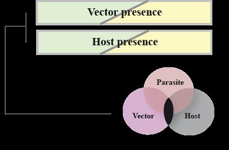
4 One mosquito bites an infected man Reservoir host The pathogenic complex Vector One infected mosquito bites a man The epidemiological chain of malaria 4

5 Limited anophelian development Uneven exposure of hosts regarding vectors Vulnerability of some populations to the parasite transmission Low malaria exposure in general but a very heterogenous transmission No or just little immunity with delayed acquisition The simplified socio-pathogenic system of urban malaria 5

6 An example of socio-ecological overlapping 6
7 Type Spatial coverage Time frame Source Landcover data with 2.5 m raster size Region of Dakar satellite data from SPOT 5 Multitemporal analysis of landcover Maps on all the region of Dakar Centre de Suivi Ecologique (CSE) Socioeconomic variables 2000 CDs (Census Districts) 2002 Census ANSD Prevalence Rate 112 CDs 2008 ANR ACTUPALU Materials 7
 published in Plos one Final models")
8 Human Biting Rate (HBR) Machault V et al. (2012) published in Plos one Final models (1/2) 8
 9")
9 Borderon (2013) published in UNU-EHS Final models (2/2) 9 01/06/2015
10 10 * Chi 2 Test HBR/SoVI Comparisons Kruskal-Wallis rank sum test : Observed statistics: 15.0 p-value : Test parameters : 4 Small HBR Medium HBR High HBR Total Very low Social Vulnerability (SV.) 147 (99.8) 128 (99.4) 25 (100.8) 300 Middling SV. 133 (90.8) 109 (90.4) 31 (91.7) 273 High SV.(Dakar) 150 (93.8) 73 (93.4) 59 (94.8) 282 High SV.(Suburbs) 52 (126.7) 158 (126.2) 171 (128.0) 381 Very high SV. 9 (79.8) 21 (79.5) 210 (80.7) 240 Total CHi2 Pearson= Pr=0.000


11 The horizontal relationship at the district scale 11 Moran s I = 0,80 Moran s I = 0,87
12 Luc Anselin s BiLISA W ij : contiguity matrix Z j : value of the Z variable for the i individual U j : value of the U variable for the j individual Measuring the spatial link between HBR and social vulnerability 12
13 13 BiLISA Cluster map Pikine & Guediawaye Dakar 42% of the entomological vulnerability (HBR) is explained by the social around (Human vulnerability) permutations (max.) Significance filter: 0.01 First order contiguity Spatial Risk Approach by BiLISA
 Published in")

14 Diallo et al. (2012) Published in Plos one Epidemiological data data used for validation 14
15 BiLISA Cluster map Dakar Pikine & Guediawaye 2,5 Prevalence rate by types 2 1,5 1 Average 0,5 0 Low-Low Low-High High-High permutations (max.) Significance filter: 0.01 Prevalence rate and spatial co-location 15
16 16 Conclusion Almost half of the location of Anopheles is explained by the social vulnerability of human individuals. Suggested explanations: Vulnerable people have less choice of location, they live on /near the floodplain or wetlands- favorite landscapes for mosquitoes. Vulnerable people are less able to protect themselves from mosquitoes, which can more easily take blood meals and breed. Non-vulnerable people are more able to control their environment.
17 17 Conclusion Major contributions of the study: Recognition and statistical demonstration of the link between the physical and social attributes of the urban landscapes. Risk mapping of malaria transmission with typologies of urban areas at risk (at the district scale) - (in logic with the Hyogo Protocol).
18 18 Marion Borderon, Sébastien Oliveau UMR 7300 ESPACE, Aix Marseille Université,
Mapping Malaria Risk in Dakar, Senegal
 192 Mapping Malaria Risk in Dakar, Senegal Marion BORDERON, Sébastien OLIVEAU, Alphousseyni N'DONKY and Richard LALOU UMR 7300 ESPACE, Aix-en-Provence / France marion.borderon@univ-amu.fr This contribution
EPIDEMIOLOGY FOR URBAN MALARIA MAPPING
 TELE-EPIDEMIOLOGY EPIDEMIOLOGY FOR URBAN MALARIA MAPPING @IRD/M Dukhan Vanessa Machault Observatoire Midi-Pyrénées, Laboratoire d Aérologie Pleiades days 17/01/2012 The concept of Tele-epidemiology The
TELE-EPIDEMIOLOGY URBAN MALARIA MAPPING
 TELE-EPIDEMIOLOGY URBAN MALARIA MAPPING Ministère de la Défense Vanessa Machault Advances in Geospatial Technologies for Health 12-13/09/2011 Objective To develop a robust pre-operational methodology to
Neighborhood effects in demography: measuring scales and patterns
 Neighborhood effects in demography: measuring scales and patterns Sébastien Oliveau, Aix-Marseille University, UMR ESPACE Sebastien.oliveau@univ-amu.fr Yoann Doignon, Aix-Marseille University, UMR ESPACE
Towards a risk map of malaria for Sri Lanka
 assessing the options for control of malaria vectors through different water management practices in a natural stream that formed part of such a tank cascade system. The studies established conclusively
Cluster Analysis using SaTScan
 Cluster Analysis using SaTScan Summary 1. Statistical methods for spatial epidemiology 2. Cluster Detection What is a cluster? Few issues 3. Spatial and spatio-temporal Scan Statistic Methods Probability
Use of remotely sensed environmental and meteorological data for mapping malaria and dengue entomological risk
 Use of remotely sensed environmental and meteorological data for mapping malaria and dengue entomological risk Vanessa Machault 1 Cécile Vignolles 2 André Yébakima 3 Christophe Rogier 4 Jean-Pierre Lacaux
Spatial correlation and demography.
 Spatial correlation and demography. Sébastien Oliveau, Christophe Guilmoto To cite this version: Sébastien Oliveau, Christophe Guilmoto. Spatial correlation and demography.: Exploring India s demographic
Risk Mapping of Anopheles gambiae s.l. Densities Using Remotely-Sensed Environmental and Meteorological Data in an Urban Area: Dakar, Senegal
 Risk Mapping of Anopheles gambiae s.l. Densities Using Remotely-Sensed Environmental and Meteorological Data in an Urban Area: Dakar, Senegal Vanessa Machault 1,2,3 *,Cécile Vignolles 3, Frédéric Pagès
Geographical Information System (GIS)-based maps for monitoring of entomological risk factors affecting transmission of chikungunya in Sri Lanka
-based maps for monitoring of entomological risk factors affecting transmission of chikungunya in Sri Lanka") Geographical Information System (GIS)-based maps for monitoring of entomological risk factors affecting transmission of chikungunya in Sri Lanka M.D. Hapugoda 1, N.K. Gunewardena 1, P.H.D. Kusumawathie
Geographical Information System (GIS)-based maps for monitoring of entomological risk factors affecting transmission of chikungunya in Sri Lanka M.D. Hapugoda 1, N.K. Gunewardena 1, P.H.D. Kusumawathie
Impacts of Climate Change on Public Health: Bangladesh Perspective
 Global Journal of Environmental Research 5 (3): 97-15, 211 ISSN 199-925X IDOSI Publications, 211 Impacts of Climate Change on Public Health: Bangladesh Perspective M. Ruhul Amin, S.M. Tareq and S.H. Rahman
CLIMATE AND LAND USE DRIVERS OF MALARIA RISK IN THE PERUVIAN AMAZON,
 CLIMATE AND LAND USE DRIVERS OF MALARIA RISK IN THE PERUVIAN AMAZON, 2001-2012 Ben Zaitchik Johns Hopkins University Beth Feingold, Denis Valle, Alex Sandoval, Carlos Alvarez Antonio, Rosa Patricia Zegarra
Spatial Analysis of Natural Hazard and Climate Change Risks in Peri-Urban Expansion Areas of Dakar, Senegal
 1 Spatial Analysis of Natural Hazard and Climate Change Risks in Peri-Urban Expansion Areas of Dakar, Senegal URBAN WEEK 2009 BBL Preston Lounge Thursday, March 12, 2009 Christian Hoffmann GeoVille group
CSISS Center for Spatial Information Science Page 1 and Systems
 Does urbanization play a big role in the rapid increase of Lyme disease cases? Liping Di, Liying Guo Center for Spatial Information Science () George Mason University Fairfax, Virginia, USA ldi@gmu.edu
The Response of Environmental Capacity for Malaria Transmission in West Africa to Climate Change
 AGU Fall Meeting December 9, 2011 The Response of Environmental Capacity for Malaria Transmission in West Africa to Climate Change Teresa K. Yamana & Elfatih A.B. Eltahir MIT Dept. of Civil & Environmental
Vector Hazard Report: Malaria in Ghana Part 1: Climate, Demographics and Disease Risk Maps
 Vector Hazard Report: Malaria in Ghana Part 1: Climate, Demographics and Disease Risk Maps Information gathered from products of The Walter Reed Biosystematics Unit (WRBU) VectorMap Systematic Catalogue
Environmental Influences on Infection Disease Risk: Studies at Different Spatial Scales
 Environmental Influences on Infection Disease Risk: Studies at Different Spatial Scales Mark L. Wilson Department of Epidemiology Department of Ecology and Evolutionary Biology The University of Michigan
EXPLORATORY SPATIAL DATA ANALYSIS OF BUILDING ENERGY IN URBAN ENVIRONMENTS. Food Machinery and Equipment, Tianjin , China
 EXPLORATORY SPATIAL DATA ANALYSIS OF BUILDING ENERGY IN URBAN ENVIRONMENTS Wei Tian 1,2, Lai Wei 1,2, Pieter de Wilde 3, Song Yang 1,2, QingXin Meng 1 1 College of Mechanical Engineering, Tianjin University
Predicting Malaria Epidemics in Ethiopia
 Predicting Malaria Epidemics in Ethiopia Eskindir Loha, Hawassa University Torleif Markussen Lunde, UoB 5th Conference on Global Health and Vaccination Research: Environmental Change and Global Health
MULTI-SCALE MODELING OF MALARIA: FROM ENDEMICITY TO ELIMINATION
 MULTI-SCALE MODELING OF MALARIA: FROM ENDEMICITY TO ELIMINATION or the DEATH of SEIR models Juan B. Gutierrez UGA s Department of Mathematics & Institute of Bioinformatics December 14, 2012 1 / 19 Collaborators
Climate Variability and Malaria over the Sahel Country of Senegal
 Climate Variability and Malaria over the Sahel Country of Senegal Ibrahima DIOUF CPC International Desks NOAA Center for Weather and Climate Prediction 5830 University Research Court, College Park, Maryland
Role of GIS and Remote Sensing to Environment Statistics
 United Nations Economic Commission for Africa Role of GIS and Remote Sensing to Environment Dozie Ezigbalike Data Management Coordinator A Definition Environment statistics are statistics that describe
Introduction to Spatial Statistics and Modeling for Regional Analysis
 Introduction to Spatial Statistics and Modeling for Regional Analysis Dr. Xinyue Ye, Assistant Professor Center for Regional Development (Department of Commerce EDA University Center) & School of Earth,
Determining Important Parameters in the Spread of Malaria Through the Sensitivity Analysis of a Mathematical Model
 Bulletin of Mathematical Biology (2008) 70: 1272 1296 DOI 10.1007/s11538-008-9299-0 ORIGINAL ARTICLE Determining Important Parameters in the Spread of Malaria Through the Sensitivity Analysis of a Mathematical
Examples of Vulnerability Assessment Aggregation Results from other Regions. Spatial Vulnerability Assessments
 Examples of Vulnerability Assessment Aggregation Results from other Regions Potential Vulnerability to Climate change in the European Union Kathrin Renner EURAC.Research,, Risk, Vulnerability and Climate
Landscape characterization of Rift Valley Fever risk areas using very high spatial resolution imagery : case study in the Ferlo area, Senegal.
 Landscape characterization of Rift Valley Fever risk areas using very high spatial resolution imagery : case study in the Ferlo area, Senegal. V.Soti 1,2,3, V.Chevalier 1, J.Maura 1, D.Sow 5, A. Begue
Mathematical models on Malaria with multiple strains of pathogens
 Mathematical models on Malaria with multiple strains of pathogens Yanyu Xiao Department of Mathematics University of Miami CTW: From Within Host Dynamics to the Epidemiology of Infectious Disease MBI,
Lecture 3: Exploratory Spatial Data Analysis (ESDA) Prof. Eduardo A. Haddad
 Prof. Eduardo A. Haddad") Lecture 3: Exploratory Spatial Data Analysis (ESDA) Prof. Eduardo A. Haddad Key message Spatial dependence First Law of Geography (Waldo Tobler): Everything is related to everything else, but near things
Lecture 3: Exploratory Spatial Data Analysis (ESDA) Prof. Eduardo A. Haddad Key message Spatial dependence First Law of Geography (Waldo Tobler): Everything is related to everything else, but near things
Paper Two - Optional Themes for Standard and Higher Level
 Paper Two - Optional Themes for Standard and Higher Level Timing: Approximately 40 minutes for each question (each is worth 20 marks). Choice: Higher Level candidates must answer three questions and Standard
Temporal vs. Spatial Data
 Temporal vs. Spatial Data Temporal 1 dimensional Units: day, week, month Lag: t, t-1, t-2 Durbin-Watson Spatial 2-3 dimensional Units: county, mile, region Lag: near neighbor, networks (?) Moran s I Differencing
La santé dans les villes : de l approche géographique aux collaborations entre chercheurs et décideurs
 La santé dans les villes : de l approche géographique aux collaborations entre chercheurs et décideurs Pr. Gérard Salem, Université Paris-Nanterre, ISUH-ICSu Séminaire Maladies Infectieuses Emergentes
Supporting Information
 Supporting Information Zinsstag et al. 10.1073/pnas.0904740106 Fig. S1. Sensitivity plots of model parameters show effects of parameter variability over a reasonable range of uncertainty on (a) transmission
Effects of Rainfall on Malaria Occurrences in Kenya
 Manene et al. 216 J. Meteorol. Rel. Sci., 8:2 ISSN: 2412-3781 http://dx.doi.org/1.2987/jmrs.215.1.82 Effects of Rainfall on Malaria Occurrences in Kenya Moses M. Manene *, Nzioka J. Muthama **, E. O. Ombaka
Lecture 3: Exploratory Spatial Data Analysis (ESDA) Prof. Eduardo A. Haddad
 Prof. Eduardo A. Haddad") Lecture 3: Exploratory Spatial Data Analysis (ESDA) Prof. Eduardo A. Haddad Key message Spatial dependence First Law of Geography (Waldo Tobler): Everything is related to everything else, but near things
Lecture 3: Exploratory Spatial Data Analysis (ESDA) Prof. Eduardo A. Haddad Key message Spatial dependence First Law of Geography (Waldo Tobler): Everything is related to everything else, but near things
Agro Ecological Malaria Linkages in Uganda, A Spatial Probit Model:
 Agro Ecological Malaria Linkages in Uganda, A Spatial Probit Model: IFPRI Project Title: Environmental management options and delivery mechanisms to reduce malaria transmission in Uganda Spatial Probit
Selection should be based on the desired biological interpretation!
 Statistical tools to compare levels of parasitism Jen_ Reiczigel,, Lajos Rózsa Hungary What to compare? The prevalence? The mean intensity? The median intensity? Or something else? And which statistical
Using Geospatial Methods with Other Health and Environmental Data to Identify Populations
 Using Geospatial Methods with Other Health and Environmental Data to Identify Populations Ellen K. Cromley, PhD Consultant, Health Geographer ellen.cromley@gmail.com Purpose and Outline To illustrate the
Identifying, mapping and modelling trajectories of neighbourhood poverty in metropolitan areas: The case of Montreal
 Identifying, mapping and modelling trajectories of neighbourhood poverty in metropolitan areas: The case of Montreal Philippe Apparicio (INRS-UCS) Anne-Marie Séguin (INRS-UCS) Mylène Riva (Centre de recherche
The Use of Spatial Weights Matrices and the Effect of Geometry and Geographical Scale
 The Use of Spatial Weights Matrices and the Effect of Geometry and Geographical Scale António Manuel RODRIGUES 1, José António TENEDÓRIO 2 1 Research fellow, e-geo Centre for Geography and Regional Planning,
A diffusion model to predict spatial and temporal population dynamics of Rift valley fever vectors in Northern Senegal
 A diffusion model to predict spatial and temporal population dynamics of Rift valley fever vectors in Northern Senegal Soti V., Tran A., Fontenille D, Lancelot R, Chevalier V., Thiongane Y., Degenne P.,
Unit No-1&2. Settlement Geography
 Unit No-1&2 Settlement Geography TYPES OF SETTLEMENTS Rural Settlements - agriculture as the predominant occupation. Urban settlements - principal industries are secondary and tertiary. Rural Settlement:
Climate variability and the population dynamics of diarrheal diseases
 Climate variability and the population dynamics of diarrheal diseases Mercedes Pascual University of Chicago and The Santa Fe Institute 1 Cholera cases London, 1854 Bangladesh, 2000 Time courtesy ICDDR,
Assessing the Regional Vulnerability of Large Scale Mining in Ghana: An Application of Multi Criteria Analysis
 Assessing the Regional Vulnerability of Large Scale Mining in Ghana: An Application of Multi Criteria Analysis Mukesh Subedee, GISDE 14 Arun Poojary, ES&P 13 Clark University April 29, 2013 Ghana: A case
PRE DICT. PREDICT Project. Prevent and Respond to Epidemics and Demonstrate Information and Communication Technologies.
 PRE DICT PREDICT Project Prevent and Respond to Epidemics and Demonstrate Information and Communication Technologies IAC Conference October 5 th 2011 DSV Context About 75 % of the new diseases having affected
Regional seasonal forecasting activities at ICTP: climate and malaria
 Regional seasonal forecasting activities at ICTP: climate and malaria WGSIP, MPI Hamburg, September 2012 Adrian M Tompkins (tompkins@ictp.it) Earth System Physics, ICTP, Trieste, Italy Climate and malaria
A mathematical model for malaria involving differential susceptibility, exposedness and infectivity of human host
 A mathematical model for malaria involving differential susceptibility exposedness and infectivity of human host A. DUCROT 1 B. SOME 2 S. B. SIRIMA 3 and P. ZONGO 12 May 23 2008 1 INRIA-Anubis Sud-Ouest
Understanding the contribution of space on the spread of Influenza using an Individual-based model approach
 Understanding the contribution of space on the spread of Influenza using an Individual-based model approach Shrupa Shah Joint PhD Candidate School of Mathematics and Statistics School of Population and
Seymour Centre 2017 Education Program 2071 CURRICULUM LINKS
 Suitable for: Stage 5 Stage 6 HSC Subject Links: Seymour Centre 2017 Education Program 2071 CURRICULUM LINKS Science Stage Content Objective Outcomes Stage 5 Earth and Space ES3: People use scientific
Spatial Data, Spatial Analysis and Spatial Data Science
 Spatial Data, Spatial Analysis and Spatial Data Science Luc Anselin http://spatial.uchicago.edu 1 spatial thinking in the social sciences spatial analysis spatial data science spatial data types and research
Potential to use seasonal climate forecasts to plan malaria intervention strategies in Africa
 from Newsletter Number 140 Summer 2014 METEOROLOGY Potential to use seasonal climate forecasts to plan malaria intervention strategies in Africa Salem Alkait/iStock/Thinkstock doi:10.21957/z1mx6pcl This
USE OF GEOREFERENCE INFORMATION FOR DRM Arnob Bormdoi Research Associate, GIC
 USE OF GEOREFERENCE INFORMATION FOR DRM Arnob Bormdoi Research Associate, GIC CONTENTS INTRODUCTION THE IMPORTANCE OF SPATIAL INFORMATION CASE STUDIES SUMMARY INTRODUCTION The process of defining how raster
Chisoni Mumba. Presentation made at the Zambia Science Conference 2017-Reseachers Symposium, th November 2017, AVANI, Livingstone, Zambia
 Application of system dynamics and participatory spatial group model building in animal health: A case study of East Coast Fever interventions in Lundazi and Monze districts of Zambia Chisoni Mumba Presentation
Spatial Analysis I. Spatial data analysis Spatial analysis and inference
 Spatial Analysis I Spatial data analysis Spatial analysis and inference Roadmap Outline: What is spatial analysis? Spatial Joins Step 1: Analysis of attributes Step 2: Preparing for analyses: working with
Spatially variable risk factors for malaria in a geographically heterogeneous landscape, western Kenya: an explorative study
 DOI 10.1186/s12936-015-1044-1 Malaria Journal RESEARCH Open Access Spatially variable risk factors for malaria in a geographically heterogeneous landscape, western Kenya: an explorative study Tobias Homan
Where Do Overweight Women In Ghana Live? Answers From Exploratory Spatial Data Analysis
 Where Do Overweight Women In Ghana Live? Answers From Exploratory Spatial Data Analysis Abstract Recent findings in the health literature indicate that health outcomes including low birth weight, obesity
Spatial Trends of unpaid caregiving in Ireland
 Spatial Trends of unpaid caregiving in Ireland Stamatis Kalogirou 1,*, Ronan Foley 2 1. NCG Affiliate, Thoukididi 20, Drama, 66100, Greece; Tel: +30 6977 476776; Email: skalogirou@gmail.com; Web: http://www.gisc.gr.
Achieving the Vision Geo-statistical integration addressing South Africa s Developmental Agenda. geospatial + statistics. The Data Revolution
 Achieving the Vision Geo-statistical integration addressing South Africa s Developmental Agenda geospatial + statistics The Data Revolution humble beginnings, present & future - South Africa UN World Data
School of Environmental Sciences, Bharathidasan University, Tiruchirappalli Centre for Research in Medical Entomology, Madurai
 Development Vector Surveillance System through Bio-spatial Technology for Better Public Health Services A case study M. Govindaraju 1, P. Suganthi 1, V.Thenmozhi 2 and B.K. Tyagi 2 1 Bio - Spatial Technology
The Case for Space in the Social Sciences
 The Case for Space in the Social Sciences Don Janelle Center for Spatially Integrated Social Science University of California, Santa Barbara Roundtable on Geographical Voices and Geographical Analysis
Landscape Epidemiology Modeling Using an Agent-Based Model and a Geographic Information System
 Land 2015, 4, 37-412; doi:10.3390/land402037 OPEN ACCESS land ISSN 2073-445X www.mdpi.com/journal/land Article Landscape Epidemiology Modeling Using an Agent-Based Model and a Geographic Information System
Approach to identifying hot spots for NCDs in South Africa
 Approach to identifying hot spots for NCDs in South Africa HST Conference 6 May 2016 Noluthando Ndlovu, 1 Candy Day, 1 Benn Sartorius, 2 Karen Hofman, 3 Jens Aagaard-Hansen 3,4 1 Health Systems Trust,
Spatio-temporal modeling of weekly malaria incidence in children under 5 for early epidemic detection in Mozambique
 Spatio-temporal modeling of weekly malaria incidence in children under 5 for early epidemic detection in Mozambique Katie Colborn, PhD Department of Biostatistics and Informatics University of Colorado
GIS in Weather and Society
 GIS in Weather and Society Olga Wilhelmi Institute for the Study of Society and Environment National Center for Atmospheric Research WAS*IS November 8, 2005 Boulder, Colorado Presentation Outline GIS basic
SECTION III Meteorological, climatological and biological risk
 Chapter 3 Understanding disaster risk: hazard related risk issues SECTION III Meteorological, climatological and biological risk Virginia Murray Coordinating lead author Thomas Frame Lead author 3.7 Giles
Spatial Variation in Hospitalizations for Cardiometabolic Ambulatory Care Sensitive Conditions Across Canada
 Spatial Variation in Hospitalizations for Cardiometabolic Ambulatory Care Sensitive Conditions Across Canada CRDCN Conference November 14, 2017 Martin Cooke Alana Maltby Sarah Singh Piotr Wilk Today s
Least-Cost Transportation Corridor Analysis Using Raster Data.
 Least-Cost Transportation Corridor Analysis Using Raster Data What is GeoMedia Grid: Key Grid Concepts Vector Model Vector based systems show data by means of a series of points, lines, and polygons. Each
EpiMAN-TB, a decision support system using spatial information for the management of tuberculosis in cattle and deer in New Zealand
 EpiMAN-TB, a decision support system using spatial information for the management of tuberculosis in cattle and deer in New Zealand J.S. McKenzie 1, R.S. Morris 1, C.J. Tutty 2, D.U. Pfeiffer 1 Dept of
Spatial Regression. 1. Introduction and Review. Luc Anselin. Copyright 2017 by Luc Anselin, All Rights Reserved
 Spatial Regression 1. Introduction and Review Luc Anselin http://spatial.uchicago.edu matrix algebra basics spatial econometrics - definitions pitfalls of spatial analysis spatial autocorrelation spatial
Tracey Farrigan Research Geographer USDA-Economic Research Service
 Rural Poverty Symposium Federal Reserve Bank of Atlanta December 2-3, 2013 Tracey Farrigan Research Geographer USDA-Economic Research Service Justification Increasing demand for sub-county analysis Policy
Spanish national plan for land observation: new collaborative production system in Europe
 ADVANCE UNEDITED VERSION UNITED NATIONS E/CONF.103/5/Add.1 Economic and Social Affairs 9 July 2013 Tenth United Nations Regional Cartographic Conference for the Americas New York, 19-23, August 2013 Item
Local Spatial Autocorrelation Clusters
 Local Spatial Autocorrelation Clusters Luc Anselin http://spatial.uchicago.edu LISA principle local Moran local G statistics issues and interpretation LISA Principle Clustering vs Clusters global spatial
Use of Climate information in Disaster Risk Management in Zimbabwe
 Use of Climate information in Disaster Risk Management in Zimbabwe WMO Regional Technical Meeting & User/CONOPS Workshop, 28 th October 2015 Lameck Betera Department of Civil Protection Institutional Arrangements
Outline ESDA. Exploratory Spatial Data Analysis ESDA. Luc Anselin
 Exploratory Spatial Data Analysis ESDA Luc Anselin University of Illinois, Urbana-Champaign http://www.spacestat.com Outline ESDA Exploring Spatial Patterns Global Spatial Autocorrelation Local Spatial
Mapping and Analysis for Spatial Social Science
 Mapping and Analysis for Spatial Social Science Luc Anselin Spatial Analysis Laboratory Dept. Agricultural and Consumer Economics University of Illinois, Urbana-Champaign http://sal.agecon.uiuc.edu Outline
Department of Geography: Vivekananda College for Women. Barisha, Kolkata-8. Syllabus of Post graduate Course in Geography
 India: Regional Problems and Resource management Module 11 (Full Marks 50) Unit I: Region and Regionalisation 1.1 Various bases of regionalisation of India; problems of identification and delineation.
A geographical location model for targeted implementation of lure-and-kill strategies against disease-transmitting mosquitoes in rural areas
 A geographical location model for targeted implementation of lure-and-kill strategies against disease-transmitting mosquitoes in rural areas Robert D. Sumaye 1, Dickson W. Lwetoijera 1,2, Edith P. Madumla
The spatial convergence of population aging in southern Europe
 The spatial convergence of population aging in southern Europe Yoann Doignon, Laurence Reboul, Sébastien Oliveau To cite this version: Yoann Doignon, Laurence Reboul, Sébastien Oliveau. The spatial convergence
Belfairs Academy GEOGRAPHY Fundamentals Map
 YEAR 12 Fundamentals Unit 1 Contemporary Urban Places Urbanisation Urbanisation and its importance in human affairs. Global patterns of urbanisation since 1945. Urbanisation, suburbanisation, counter-urbanisation,
How rural the EU RDP is? An analysis through spatial funds allocation
 How rural the EU RDP is? An analysis through spatial funds allocation Beatrice Camaioni, Roberto Esposti, Antonello Lobianco, Francesco Pagliacci, Franco Sotte Department of Economics and Social Sciences
Determine the flooded area based on elevation information and the current water level
 Identifying Data Needs Identifying Data Needs Purpose Before looking for data, the methodology needs to be analyzed to establish what data is needed The most important question that needs to be answered
An Introduction to SaTScan
 An Introduction to SaTScan Software to measure spatial, temporal or space-time clusters using a spatial scan approach Marilyn O Hara University of Illinois moruiz@illinois.edu Lecture for the Pre-conference
Urban remote sensing: from local to global and back
 Urban remote sensing: from local to global and back Paolo Gamba University of Pavia, Italy A few words about Pavia Historical University (1361) in a nice town slide 3 Geoscience and Remote Sensing Society
Rencontres de l Hôtel Dieu Paris,12-13 mai C. Padilla, B Lalloue, D Zmirou-Navier, S Deguen
 Association of Proximity to Polluting Industries, Deprivation and Infant Mortality - A spatial analysis using census data Lille metropolitan Area France 1,2,4 1,4 1,2,3,4 1,2 C. Padilla, B Lalloue, D Zmirou-Navier,
Social Vulnerability explorer (SV-X)
") 311 Social Vulnerability explorer (SV-X) D. P. Lanter 1 ; S. Durden 2 ; C. Baker 3 ; and C. M. Dunning 4 1 CDM Smith, Two Penn Center Plaza, 1500 JFK Blvd, Philadelphia, PA 19102. E-mail: lanterdp@cdmsmith.com
311 Social Vulnerability explorer (SV-X) D. P. Lanter 1 ; S. Durden 2 ; C. Baker 3 ; and C. M. Dunning 4 1 CDM Smith, Two Penn Center Plaza, 1500 JFK Blvd, Philadelphia, PA 19102. E-mail: lanterdp@cdmsmith.com
2002 HSC Notes from the Marking Centre Geography
 2002 HSC Notes from the Marking Centre Geography 2003 Copyright Board of Studies NSW for and on behalf of the Crown in right of the State of New South Wales. This document contains Material prepared by
The role of topological outliers in the spatial analysis of georeferenced social media data
 06 April 2017 The role of topological outliers in the spatial analysis of georeferenced social media data René Westerholt, Heidelberg University Seminar on Spatial urban analytics: big data, methodologies,
NREL, Intro to GIS for Wind Energy Siting for IGERT Wind NSF
 NREL, 2010 Intro to GIS for Wind Energy Siting for IGERT Wind NSF Challenge: How to encourage offshore wind in the US while managing ecological responsibility and ocean use conflicts? Introduction NREL,
Summary Description Municipality of Anchorage. Anchorage Coastal Resource Atlas Project
 Summary Description Municipality of Anchorage Anchorage Coastal Resource Atlas Project By: Thede Tobish, MOA Planner; and Charlie Barnwell, MOA GIS Manager Introduction Local governments often struggle
Analysis of SIR Mathematical Model for Malaria disease with the inclusion of Infected Immigrants
 IOSR Journal of Mathematics (IOSR-JM) e-issn: 2278-5728, p-issn: 2319-765X. Volume 14, Issue 5 Ver. I (Sep - Oct 218), PP 1-21 www.iosrjournals.org Analysis of SIR Mathematical Model for Malaria disease
Presented to Sub-regional workshop on integration of administrative data, big data and geospatial information for the compilation of SDG indicators
 Presented to Sub-regional workshop on integration of administrative data, big data and geospatial information for the compilation of SDG indicators 23-25 April,2018 Addis Ababa, Ethiopia By: Deogratius
Understanding the role of land cover / land use nexus in malaria transmission under changing socio-economic climate in Myanmar
 Annual Report for Year 1 June, 2017 January, 2018 NASA Land Cover Land Use Change Program Funded under grant # NNX17AI06G: Understanding the role of land cover / land use nexus in malaria transmission
Notes On R 0. James Holland Jones Department of Anthropological Sciences Stanford University. October 17, 2013
 Notes On R James Holland Jones Department of Anthropological Sciences Stanford University October 17, 213 1 The Basic Reproduction Number in a Nutshell The basic reproduction number, R, is defined as the
Spatiotemporal Analysis of Urban Traffic Accidents: A Case Study of Tehran City, Iran
 Spatiotemporal Analysis of Urban Traffic Accidents: A Case Study of Tehran City, Iran January 2018 Niloofar HAJI MIRZA AGHASI Spatiotemporal Analysis of Urban Traffic Accidents: A Case Study of Tehran
GIS and Health Geography. What is epidemiology?
 GIS and Health Geography { What is epidemiology? TOC GIS and health geography Major applications for GIS Epidemiology What is health (and how location matters) What is a disease (and how to identify one)
Evaluation of Land Use Changes on Schistosomiasis Disease Prevalence in Sichuan Province, China
 Evaluation of Land Use Changes on Schistosomiasis Disease Prevalence in Sichuan Province, China Abstract This study examines the impact that 5 land use/land cover types have had on schistosomiasis human
Role of GIS in Tracking and Controlling Spread of Disease
 Role of GIS in Tracking and Controlling Spread of Disease For Dr. Baqer Al-Ramadan By Syed Imran Quadri CRP 514: Introduction to GIS Introduction Problem Statement Objectives Methodology of Study Literature
Data sources and classification for ecosystem accounting g
 Data sources and classification for ecosystem accounting Ken Bagstad 23 February 2015 Wealth Accounting and the Valuation of Ecosystem Services www.wavespartnership.org Data sources and classification
SPACE Workshop NSF NCGIA CSISS UCGIS SDSU. Aldstadt, Getis, Jankowski, Rey, Weeks SDSU F. Goodchild, M. Goodchild, Janelle, Rebich UCSB
 SPACE Workshop NSF NCGIA CSISS UCGIS SDSU Aldstadt, Getis, Jankowski, Rey, Weeks SDSU F. Goodchild, M. Goodchild, Janelle, Rebich UCSB August 2-8, 2004 San Diego State University Some Examples of Spatial
Climate and Health Vulnerability & Adaptation Assessment Profile Manaus - Brazil
 Climate and Health Vulnerability & Adaptation Assessment Profile Manaus - Brazil Christovam Barcellos (ICICT/Fiocruz) Diego Xavier Silva (ICICT/Fiocruz) Rita Bacuri (CPqLMD/Fiocruz) Assessment Objectives
Mathematical Modeling and Analysis of Infectious Disease Dynamics
 Mathematical Modeling and Analysis of Infectious Disease Dynamics V. A. Bokil Department of Mathematics Oregon State University Corvallis, OR MTH 323: Mathematical Modeling May 22, 2017 V. A. Bokil (OSU-Math)