Examples of Vulnerability Assessment Aggregation Results from other Regions. Spatial Vulnerability Assessments
|
|
|
- Carmella Hunter
- 6 years ago
- Views:
Transcription


1 Examples of Vulnerability Assessment Aggregation Results from other Regions Potential Vulnerability to Climate change in the European Union Kathrin Renner EURAC.Research,, Risk, Vulnerability and Climate Change Unit, Bolzano Italy, Spatial Vulnerability Assessments Advantages Disadvantages - presents a large amount of information in a simplified and visually attractive manner - Maps summarise and synthesise information in a way to be useful for policy decisions - Uncertainties in the data and important analytical assumptions may be hidden from the user - Impediments with data availability and accuracy, methodological issues and other issues that arise in any assessment process 1
2 Spatial Vulnerability Assessments variety of studies Purposes vary according to the specific study, however, generally intended to have the same objectives: to identify areas at potentially high risk of climate impacts so-called climate change hotspots and to identify planning and capacity building needs or to better target funding and adaptation programs There is as yet no consensus on what constitutes best practise in spatial Vulnerability Assessments Over recent years the number of spatial VAs increased; conceptualisations, methods, and data used to assess vulnerability multiplied All of the commonly used methodologies have their strengths and weaknesses Examples from other Regions (1) Example 1: Regional Climate Change Programme: Southern Africa Aim: Explore where current and future climate stressors have the greatest impact within the SADC region, and how adaptive capacity could shape the vulnerability of communities Hotspot analysis Method: - Indicator based. For current situation (2008) and future (2050), weighting - Weighted overlay of indicators for each component - Weightings from 1 to 3 - Classification on a scale from 1 to 9 (using Jenks classification or logarithmic) - Exposure (8) and Sensitivity (23) indicators combined to single layer representing Impact of climate related stressors. Then combining this with values from Adaptive Capacity (12) analysis to get vulnerability Hotspots - Smoothing analysis to calculate average values for the data within a search radius of 50km, to identify locations for centres of hotspots 6 2
 Davies, R.A.G., & Midgley, S.J.E. (2010).")
 Ltd.")
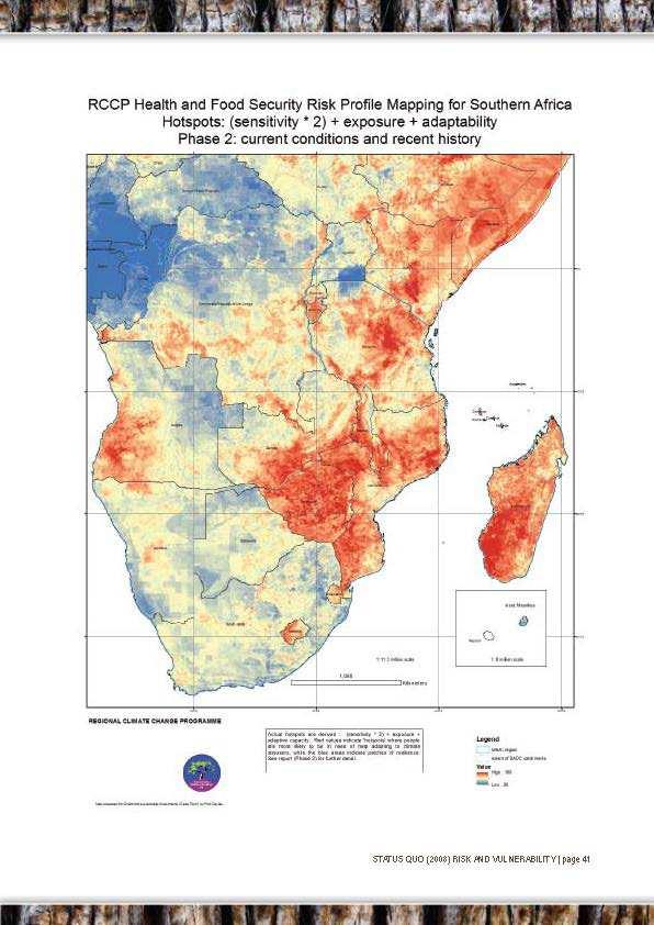
3 Examples from other Regions (1 cont d) Vulnerability values range from 1 to 10, where 1 is low (blue) and 10 is high (red) Davies, R.A.G., & Midgley, S.J.E. (2010). Risk and vulnerability mapping in Southern Africa: a hotspot analysis Adaptation Series. Cape Town, South Africa: OneWorld Sustainable Investments (Pty) Ltd. 7 Examples from other Regions (1 cont d) Values range from 1 to 10, where 1 is low (blue) and 10 is high (red) Davies, R.A.G., & Midgley, S.J.E. (2010). Risk and vulnerability mapping in Southern Africa: a hotspot analysis Adaptation Series. Cape Town, South Africa: OneWorld Sustainable Investments (Pty) Ltd. 8 3
 Ltd.")
4 Examples from other Regions (1 cont d) Comparision between the hotspot areas for current (2008) and future (2015) conditions Davies, R.A.G., & Midgley, S.J.E. (2010). Risk and vulnerability mapping in Southern Africa: a hotspot analysis Adaptation Series. Cape Town, South Africa: OneWorld Sustainable Investments (Pty) Ltd. Values range from 1 to 10, where 1 is low (blue) and 10 is high (red) 9 Examples from other Regions (1 cont d) Principal Component Analysis (PCA)

5 Examples from other Regions (2) Example 2: Burundi Aim: Identification of climate change hotspots to target funding and adaptation programs Spatial scale: national and local VA carried out for three Vulnerabilities: Malaria, Erosion and Drought Method: Vulnerability composed of exposure, sensitivity and adaptive capacity. Process: workshops in country to develop impact chains, define indicators and weights Data: Climate projections at 25km resolution for two time periods in the future for RCP 4.5 and 8.5 (raster), Sensitivity indicators (vector) mostly on municipality level, Adaptive Capacity indicators (vector) on provincial level Classification: Vulnerabilities ranged from 1 to 5 (displayed on maps as stretched colour scheme) Examples from other Regions (2 cont d) 5

6 Examples from other Regions (2 cont d) Examples from other Regions (2 cont d) 6
7 Examples from other Regions (3) Example 3: Pan-european Vulnerability Assessment ESPON Climate project basis for identifying regional typologies of climate change exposure, sensitivity, impact and vulnerability tailor-made adaptation options can be derived which are able to cope with regionally specific patterns of climate change seven case studies from the transnational to the very local level Weighting by Delphi-based approach (questionnaire survey) ESPON Climate. (2011). Climate Change and Territorial Effects on Regions and Local Economies. Applied Research 2013/1/4. Final Report, Version 31/5/ ort_final.pdf Source: ESPON Climate Climate Change and Territorial Effectson Regions and Local Economies - Applied Research 2013/1/4 Summary Report 7


8 Potential economic impact of climate change Aggregated potential impact of climate change 8
9 Capacity to adapt to Climate change Potential Vulnerability to Climate change 9
10 Change in regional exposure to coastal storm surge events Inputs: - Storm surge heights of a 100-year return event (no CC proj. Incl.) - Ass.: due to Sea-level-rise storm surge heights increase 1m - Based on global DEM Hydro1k (USGS 2010), 1km resolution, calculated which areas would be additionally inundated by coastal flooding Potential physical impact of climate change This pattern results from sea level rise and a projected increase in river floods. It fits well with the climate change types North-western and Northern Europe which came out of the cluster analysis. 10
11 Some other studies Vulnerability studies with a sectoral focus: - Vulnerability Assessment for climate change and the fisheries and the Aquaculture sector by the FAO Vulnerability studies using PCA: - Mali: de Sherbinin, A., Chai-Onn, T., Giannini, A., Jaiteh, M., Levy, M., Mara, V., and Pistolesi, L. (2014). Mali Climate Vulnerability Mapping. Technical Report for the USAID African and Latin American Resilience to Climate Change (ARCC) project. Washington, DC: USAID. Retrieved from - U.S.A.: Cutter, S.L., Boruff, B.J., and Shirley, W.L. (2003). Social Vulnerability to Environmental Hazards*. Social Science Quarterly, 84(2), Retrieved from / Germany: Fekete, A. (2010). Social vulnerability to river floods in Germany. UNU-EHS Graduate Research Series, PhD Dissertation. (Vol. 4) 23 Thank you for your attention! 11
Arctic Adaptation Research Considerations and Challenges
 Arctic Adaptation Research Considerations and Challenges Dr Grete K. Hovelsrud, Research Director CICERO- Center for International Climate and Environmental Research Oslo, Norway Many Strong Voices Stakeholder
European spatial policy and regionalised approaches
 Findings of the ESPON 2006 Programme COMMIN Final Conference 26-27 April 2007 European spatial policy and regionalised approaches by Dr. Kai BöhmeB ! Territory matters Structure of presentation! Territorial
Seamless weather and climate for security planning
 Seamless weather and climate for security planning Kirsty Lewis, Principal Climate Change Consultant, Met Office Hadley Centre 28 June 2010 Global Climate Models Mitigation timescale changes could be avoided
Use of climate reanalysis for EEA climate change assessment. Blaz Kurnik. European Environment Agency (EEA)
") Use of climate reanalysis for EEA climate change assessment Blaz Kurnik European Environment Agency (EEA) 2016: EEA content priorities Circular economy Climate and Energy Sustainable Development Goals
Use of climate reanalysis for EEA climate change assessment Blaz Kurnik European Environment Agency (EEA) 2016: EEA content priorities Circular economy Climate and Energy Sustainable Development Goals
The ESPON Programme. Goals Main Results Future
 The ESPON Programme Goals Main Results Future Structure 1. Goals Objectives and expectations Participation, organisation and networking Themes addressed in the applied research undertaken in ESPON projects
RISC-KIT: EWS-DSS Hotspot Tool
 RISC-KIT: EWS-DSS Hotspot Tool Robert McCall Ap van Dongeren Deltares www.risckit.eu This project has received funding from the European Union s Seventh Programme for Research, Technological Development
Vulnerability and Adaptation to Climate Change
 Vulnerability and Adaptation to Climate Change Prof. Dr. Christoph Görg Department of Social Sciences, University of Kasssel Head of Department Environmental Politics, UFZ Leipzig 1 Introduction: Climate
Coastal Inundation Forecasting Demonstration Project CIFDP. Flood Forecasting Initiative-Advisory Group (FFI-AG 3), Geneva, 5-7 Dec, 2017
, Geneva, 5-7 Dec, 2017") Coastal Inundation Forecasting Demonstration Project CIFDP Flood Forecasting Initiative-Advisory Group (FFI-AG 3), Geneva, 5-7 Dec, 2017 Coastal Flooding & Vulnerable Populations Coastal populations are
Coastal Inundation Forecasting Demonstration Project CIFDP Flood Forecasting Initiative-Advisory Group (FFI-AG 3), Geneva, 5-7 Dec, 2017 Coastal Flooding & Vulnerable Populations Coastal populations are
Poland, European Territory, ESPON Programme Warsaw, 2 July 2007 STRATEGY OF THE ESPON 2013 PROGRAMME
 Poland, European Territory, ESPON Programme 2007-2013 Warsaw, 2 July 2007 STRATEGY OF THE ESPON 2013 PROGRAMME Territory matters Regional diversity as asset Territorial potentials increasing in importance
17 th Session of RA IV
 17 th Session of RA IV Agenda Item 4.1: Disaster Risk Reduction, Resilience and Prevention, Focusing on Impact-Based Decision Support Services Doc 4.1.(6):Coastal Inundation Forecasting Demonstration Project
Tackling MSP integration challenges in the BSR
 Towards sustainable governance of Baltic marine space 2015 2018 BALTSPACE Towards sustainable governance of Baltic marine space Tackling MSP integration challenges in the BSR Michael Gilek, Södertörn University,
National Disaster Management Centre (NDMC) Republic of Maldives. Location
 Republic of Maldives. Location") National Disaster Management Centre (NDMC) Republic of Maldives Location Country Profile 1,190 islands. 198 Inhabited Islands. Total land area 300 sq km Islands range b/w 0.2 5 sq km Population approx.
National Disaster Management Centre (NDMC) Republic of Maldives Location Country Profile 1,190 islands. 198 Inhabited Islands. Total land area 300 sq km Islands range b/w 0.2 5 sq km Population approx.
Alps Results from the ESPON Project. Common spatial perspectives for the Alpine area. Towards a common vision
 Results from the ESPON Project Alps 2050 Common spatial perspectives for the Alpine area. Towards a common vision Tobias Chilla, University of Erlangen Cooperation Alps 2020+ 1 & 2 October 2018 Salzburg
Overview of proposed approach to the Desktop Study to inform discussion
 LTAS Phase 2: Climate Change Implications for the Human Settlements sector in South Africa Overview of proposed approach to the Desktop Study to inform discussion Project Team Project Lead: Crispian Olver
Launch of the ESPON 2013 Programme. European observation network on territorial development and cohesion
 Launch of the ESPON 2013 Programme European observation network on territorial development and cohesion Framework conditions for the ESPON 2013 Programme Policy development in use of territorial evidence
Mediterranean Sea and Territorial Development, Opportunities and Risks
 EESC Hearing Towards an EU Macro-Regional Strategy for the Mediterranean Mediterranean Sea and Territorial Development, Opportunities and Risks Michaela Gensheimer Structure of Intervention Part I: What
CLIMATE RESILIENT ALTITUDINAL GRADIENTS (CRAGs)
") CLIMATE RESILIENT ALTITUDINAL GRADIENTS (CRAGs) BUILDING CLIMATE CHANGE RESILIENCE IN THE KIVU- RUSIZI WATERSHEDS Great Lake Conference Entebbe 2017 Chris Magero WHAT ARE CRAGs? Climate-Resilient Altitudinal
CLIMATE RESILIENT ALTITUDINAL GRADIENTS (CRAGs) BUILDING CLIMATE CHANGE RESILIENCE IN THE KIVU- RUSIZI WATERSHEDS Great Lake Conference Entebbe 2017 Chris Magero WHAT ARE CRAGs? Climate-Resilient Altitudinal
Improving global coastal inundation forecasting WMO Panel, UR2014, London, 2 July 2014
 Improving global coastal inundation forecasting WMO Panel, UR2014, London, 2 July 2014 Cyclone Sidr, November 2007 Hurricane Katrina, 2005 Prof. Kevin Horsburgh Head of marine physics, UK National Oceanography
Managing Risk for Development
 International Policy Workshop World Development Report 2014 Managing Risk for Development Do we understand the drivers of risk? Prof. Dr. Joern BIRKMANN UNU-EHS, Bonn, Germany birkmann@ehs.unu.edu Increasing
Methods for assessing coastal vulnerability to climate change Dr. Silvia Torresan CMCC
 Methods for assessing coastal vulnerability to climate change Dr. Silvia Torresan CMCC Milan, 4 February 2016 Lecture OUTLINE: Overview of climate change impacts in coastal zones; Coastal Vulnerability
The Twin2Go Project: From applying panaceas to mastering complexity: Towards adaptive water governance in river basins
 The Twin2Go Project: From applying panaceas to mastering complexity: Towards adaptive water governance in river basins From panaceas to context sensitive analyses and recommendations Water governance reform
GIS as a tool in flood management
 GIS for the United Nations and the International Community Conference Panel: GIS and Capacity - How Territorial Planning Benefits from Geospatial Information 3-5 April 2012 Geneva, Switzerland GIS as a
Weather Climate Science to Service Partnership South Africa
 PROJECTS UNDERWAY Title of the Weather Climate Science to Service Partnership South Africa Together, building on an existing strong partnership, South African Weather Service and the Met Office will build
PURR: POTENTIAL OF RURAL REGIONS UK ESPON WORKSHOP Newcastle 23 rd November Neil Adams
 PURR: POTENTIAL OF RURAL REGIONS UK ESPON WORKSHOP Newcastle 23 rd November 2012 Neil Adams PURR: Potential of Rural Regions Introduction Context for the project A spectrum of knowledge Rural Potentials
Newsletter # 2. Pilot sites in Greece. December 2018
 A HarmonizEd framework to Mitigate coastal EroSion promoting ICZM protocol implementation Newsletter # 2 December 2018 View of a beach in Ammolofi ( Paggaio Municipality ) Pilot sites in Greece 1. Name
Navigable maritime and river waterways in the seaside - Danube Delta area and the connected rural development
 SUMMARY OF Ph-D Thesis, with title RESEARCH STUDIES ON MANAGEMENT IMPROVEMENT OF MARITIME AND RIVER TRANSPORT ACTIVITY IN THE COASTAL AND DANUBE DELTA AREA FROM AN ENVIROMENTAL, ECONOMIC AND SOCIAL PERSPECTIVE
Urban-rural relations in Europe
 Urban-rural relations in Europe Typology of urban and rural characteristics developed by the ESPON 1.1.2 project Kaisa Schmidt-Thomé 14.12.2006 Sevilla JRC/IPTS Rural typologies -workshop ESPON 2006 Programme
Social Vulnerability explorer (SV-X)
") 311 Social Vulnerability explorer (SV-X) D. P. Lanter 1 ; S. Durden 2 ; C. Baker 3 ; and C. M. Dunning 4 1 CDM Smith, Two Penn Center Plaza, 1500 JFK Blvd, Philadelphia, PA 19102. E-mail: lanterdp@cdmsmith.com
311 Social Vulnerability explorer (SV-X) D. P. Lanter 1 ; S. Durden 2 ; C. Baker 3 ; and C. M. Dunning 4 1 CDM Smith, Two Penn Center Plaza, 1500 JFK Blvd, Philadelphia, PA 19102. E-mail: lanterdp@cdmsmith.com
Lorna V Inniss, Ph.D SAGE Workshop, New York City
 Lorna V Inniss, Ph.D SAGE Workshop, New York City 2014-05-21 Why me? The globally recognized success of the Barbados ICZM programme has generated requests for technical assistance and CD from many Governments
Climate Change Impacts and Adaptation for Coastal Transport Infrastructure in Caribbean SIDS
 UNCTAD National Workshop Saint Lucia 24 26 May 2017, Rodney Bay, Saint Lucia Climate Change Impacts and Adaptation for Coastal Transport Infrastructure in Caribbean SIDS LISCoAsT Large Scale Integrated
Jordan's Strategic Research Agenda in cultural heritage
 Jordan's Strategic Research Agenda in cultural heritage Analysis of main results Alessandra Gandini Amman, Jordan 3 rd November 2013 Main objectives The work performed had the main objective of giving
Spatial Analysis of Natural Hazard and Climate Change Risks in Peri-Urban Expansion Areas of Dakar, Senegal
 1 Spatial Analysis of Natural Hazard and Climate Change Risks in Peri-Urban Expansion Areas of Dakar, Senegal URBAN WEEK 2009 BBL Preston Lounge Thursday, March 12, 2009 Christian Hoffmann GeoVille group
Paul Bridge Meteorologist Vaisala/UKMO Work Groups/Committees: WMO/TRB/AMS
 Paul Bridge Meteorologist Vaisala/UKMO Work Groups/Committees: WMO/TRB/AMS Introduction (a) Identify and establish, if possible, inventories of transport networks in the ECE region which are vulnerable
Coastal Erosion & Climate Change: PRIDE 2005 Towards an Alaska Wind/Wave Climatology
 Coastal Erosion & Climate Change: PRIDE 2005 Towards an Alaska Wind/Wave Climatology 2 nd PRIDE Workshop August 9-10, 2005 David Atkinson, Int l Arctic Research Center, Univ. Of Alaska-Fairbanks James
Charting a Course for Coastal Climate Change Adaptation in Canada
 Tim Gage 2014, CC by 2.0 Charting a Course for Coastal Climate Change Adaptation in Canada Natascia Tamburello, M. Nelitz, J. Eyzaguirre, E. Olson, C. Cranmer AWRA Conference, Portland, OR, November 7
Climate Change Impacts and Adaptation for Coastal Transport Infrastructure in Caribbean SIDS
 UNCTAD National Workshop Jamaica 30 May 1 June 2017, Kingston, Jamaica Climate Change Impacts and Adaptation for Coastal Transport Infrastructure in Caribbean SIDS LISCoAsT Large Scale Integrated Sealevel
Thoughts on designing an external shock vulnerability index for LLDCs
 UN OHRLLS Panel Discussion Vulnerability of LLDCs to external shocks New York, 27 May 2014 Thoughts on designing an external shock vulnerability index for LLDCs Matthias Bruckner Committee for Development
Flood Level Simulation Modeling And Vulnerability Of Slums Along Musiriver, Hyderabad
 International Journal of Humanities and Social Science Invention (IJHSSI) ISSN (Online): 2319 7722, ISSN (Print): 2319 7714 Volume 7 Issue 05 Ver. I May. 2018 PP.51-56 Flood Level Simulation Modeling And
Entrepreneurship on islands and other peripheral regions. Specific Contract No 6511 implementing Framework contract No CDR/DE/16/2015/
 Entrepreneurship on islands and other peripheral regions Specific Contract No 6511 implementing Framework contract No CDR/DE/16/2015/ Aims of this study: To analyse the particular challenges and obstacles
A GIS Tool for Modelling and Visualizing Sustainability Indicators Across Three Regions of Ireland
 International Conference on Whole Life Urban Sustainability and its Assessment M. Horner, C. Hardcastle, A. Price, J. Bebbington (Eds) Glasgow, 2007 A GIS Tool for Modelling and Visualizing Sustainability
Adaptation to Climate Change in other Mountain Regions
 Adaptation to Climate Change in other Mountain Regions First Working Group of the Carpathian Convention on Adaptation to Climate Change Brussels, 4-5 February 2012 Pictures: A. Czaderna, A.& D. Nowak,
Urban Climate Resilience
 Urban Climate Resilience in Southeast Asia Partnership Project Introduction Planning for climate change is a daunting challenge for governments in the Mekong Region. Limited capacity at the municipal level,
Advancing Geoscientific Capability. Geological Survey of Finland
 Advancing Geoscientific Capability Geological Survey of Finland GTK in brief The Geological Survey of Finland (GTK) is one of the largest European centres of excellence in assessment, research and the
Modeling global, urban, and rural exposure to climate-related hazards
 Modeling global, urban, and rural exposure to climate-related hazards Elizabeth Christenson, Mark Elliott, Ovik Banerjee, Laura Hamrick, Jamie Bartram University of North Carolina Chapel Hill ESRI User
National Adaptation Geo-information System (NAGiS) project in Hungary
 project in Hungary") National Adaptation Geo-information System (NAGiS) project in Hungary Mr. Péter Kajner Hungarian Mining and Geological Survey (MBFSZ) National Adaptation Center Department CGE webinar: Geo-information
National Adaptation Geo-information System (NAGiS) project in Hungary Mr. Péter Kajner Hungarian Mining and Geological Survey (MBFSZ) National Adaptation Center Department CGE webinar: Geo-information
Climate Change Impacts and Adaptation for Coastal Transport Infrastructure in Caribbean SIDS
 UNCTAD National Workshop Saint Lucia 24 26 May 2017, Rodney Bay, Saint Lucia Climate Change Impacts and Adaptation for Coastal Transport Infrastructure in Caribbean SIDS LISCoAsT Large Scale Integrated
Figure 10. Travel time accessibility for heavy trucks
 Figure 10. Travel time accessibility for heavy trucks Heavy truck travel time from Rotterdam to each European cities respecting the prescribed speed in France on the different networks - Road, motorway
The Council Study: Social assessment approach and methodology
 Preliminary draft for internal discussion The Council Study: Social assessment approach and methodology Vientiane, September 24 2015 Social /economic assessment team Basin Development Plan (BDP) Programme
Assessing Social Vulnerability to Biophysical Hazards. Dr. Jasmine Waddell
 Assessing Social Vulnerability to Biophysical Hazards Dr. Jasmine Waddell About the Project Built on a need to understand: The pre-disposition of the populations in the SE to adverse impacts from disaster
Keywords: climate change, sustainable tourism development, resilience, adaptation. Key Messages: Introduction
 Keywords: climate change, sustainable tourism development, resilience, adaptation Key Messages: Belize s tourism industry is highly vulnerable to the potential adverse impacts of climate change, which
Social Vulnerability Index. Susan L. Cutter Department of Geography, University of South Carolina
 Social Vulnerability Index Susan L. Cutter Department of Geography, University of South Carolina scutter@sc.edu Great Lakes and St. Lawrence Cities Initiative Webinar December 3, 2014 Vulnerability The
Coastal Inundation Forecasting Demonstration Project (CIFDP)
") WMO World Meteorological Organization Working together in weather, climate and water Coastal Inundation Forecasting Demonstration Project (CIFDP) WMO Technical Commission for Oceanography and Marine Meteorology
WMO World Meteorological Organization Working together in weather, climate and water Coastal Inundation Forecasting Demonstration Project (CIFDP) WMO Technical Commission for Oceanography and Marine Meteorology
EARLY WARNING IN SOUTHERN AFRICA:
 EARLY WARNING IN SOUTHERN AFRICA: Enhancing the Meteorological Early Warning System Eugene Poolman South African Weather Service OUTLINE OF PRESENTATION Impact of Climate Change Meteorological Early Warning
Intraseasonal Characteristics of Rainfall for Eastern Africa Community (EAC) Hotspots: Onset and Cessation dates. In support of;
 Hotspots: Onset and Cessation dates. In support of;") Intraseasonal Characteristics of Rainfall for Eastern Africa Community (EAC) Hotspots: Onset and Cessation dates In support of; Planning for Resilience in East Africa through Policy, Adaptation, Research
Intraseasonal Characteristics of Rainfall for Eastern Africa Community (EAC) Hotspots: Onset and Cessation dates In support of; Planning for Resilience in East Africa through Policy, Adaptation, Research
The ESPON Programme and the use of spatial data on the European level
 The ESPON Programme and the use of spatial data on the European level Plan4Business project ISOCARP Brussels Liaison Office 29 November 2013 Marjan van Herwijnen Project Expert - ESPON Coordination Unit
Climate Security Vulnerability in Africa. Joshua W. Busby Assistant Professor, LBJ School of Public Affairs University of Texas - Austin
 Climate Security Vulnerability in Africa Joshua W. Busby Assistant Professor, LBJ School of Public Affairs University of Texas - Austin 1 AGENDA Brief overview of our project Discussion of our vulnerability
The National Spatial Strategy
 Purpose of this Consultation Paper This paper seeks the views of a wide range of bodies, interests and members of the public on the issues which the National Spatial Strategy should address. These views
Plan4all (econtentplus project)
") Plan4all (econtentplus project) Karel CHARVAT 1, Tomáš MILDORF 2 1 Help service remote sensing, Ltd., Černoleská 1600, 256 01 Benešov u Prahy, Czech Republic charvat@bnhelp.cz 2 Department of Mathematics
Plan4all (econtentplus project) Karel CHARVAT 1, Tomáš MILDORF 2 1 Help service remote sensing, Ltd., Černoleská 1600, 256 01 Benešov u Prahy, Czech Republic charvat@bnhelp.cz 2 Department of Mathematics
Third Cohesion report February 2004
 February 2004 A new partnership for cohesion Convergence, Competitiveness and Co-operation METREX meeting S. Sebastian, Luisa Sanches DG REGIO The 3rd CR structure 1. Analysis of situation and trends in
Global Challenges - Partnering with Service Providers. World Meteorological Organization. J. Lengoasa WMO Deputy Secretary-General
 WMO World Meteorological Organization Working together in weather, climate and water Global Challenges - Partnering with Service Providers J. Lengoasa WMO Deputy Secretary-General jlengoasa@wmo.int http://www.wmo.int/pages/gfcs/gfcs_en.html
Key Indicators for Territorial Cohesion & Spatial Planning Stakeholder Workshop - Project Update. 13 th December 2012 San Sebastián, Basque Country
 Key Indicators for Territorial Cohesion & Spatial Planning Stakeholder Workshop - Project Update 13 th December 2012 San Sebastián, Basque Country Key Aims Explore the use of territorial data in developing
Workshop B Spatial positioning and definition of characteristics
 This presentation expresses the author's views. It does not necessarily reflect the opinion of the ESPON Monitoring Committee, which is not liable for any use that may be made of the information provided.
Preliminary Vulnerability Assessment of Coastal Flooding Threats - Taylor County, Florida
 Preliminary Vulnerability Assessment of Coastal Flooding Threats - Taylor County, Florida North Central Florida Regional Planning Council Northeast Florida Regional Council April 28, 2016 BACKGROUND This
TOWARDS CLIMATE-RESILIENT COASTAL MANAGEMENT: OPPORTUNITIES FOR IMPROVED ICZM IN BELIZE
 TOWARDS CLIMATE-RESILIENT COASTAL MANAGEMENT: OPPORTUNITIES FOR IMPROVED ICZM IN BELIZE CHANTALLE SAMUELS Coastal Zone Management Authority and Institute The Caribbean Community Climate Change Centre VULNERABILITY
ERA-NET CRUE Funding Initiative. Risk Assessment and Risk Management in Small Urban Catchments
 ERA-NET CRUE Funding Initiative Integrate, Consolidate and Disseminate European Flood Risk Management Research Kick-off Meeting of Research Projects Risk Assessment and Risk Management in Small Urban Catchments
Economic Benefit Study on Value of Spatial Information Australian Experience
 Economic Benefit Study on Value of Spatial Information Australian Experience Dr Zaffar Sadiq Mohamed-Ghouse Director, International Relations Cooperative Research Centre for Spatial Information zsadiq@crcsi.com.au
JCOMM-CHy Coastal Inundation Forecasting Demonstration Project (CIFDP)
") WMO World Meteorological Organization Working together in weather, climate and water JCOMM-CHy Coastal Inundation Forecasting Demonstration Project (CIFDP) Coastal Flooding & Vulnerable Populations Coastal
WMO World Meteorological Organization Working together in weather, climate and water JCOMM-CHy Coastal Inundation Forecasting Demonstration Project (CIFDP) Coastal Flooding & Vulnerable Populations Coastal
ROLE OF SPATIAL PLANNING TOOLS AT MESO-SCALE IN THE MANAGEMENT OF NATURAL RESOURCES, LESSONS LEARNT FROM AFRICAN COUNTRIES
 6th Nov, 2012 ROLE OF SPATIAL PLANNING TOOLS AT MESO-SCALE IN THE MANAGEMENT OF NATURAL RESOURCES, LESSONS LEARNT FROM AFRICAN COUNTRIES Masoom Hamdard Environmental Planning and Assessment for Adaptation
Use of Geospatial data for disaster managements
 Use of Geospatial data for disaster managements Source: http://alertsystemsgroup.com Instructor : Professor Dr. Yuji Murayama Teaching Assistant : Manjula Ranagalage What is GIS? A powerful set of tools
Climate Change Adaptation for ports and navigation infrastructure
 Climate Change Adaptation for ports and navigation infrastructure The application of climate projections and observations to address climate risks in ports Iñigo Losada Research Director IHCantabria Universidad
Climate Change and Mapping of the Future Nature
 Climate Change and Mapping of the Future Nature The XXIV FIG International Congress 2010 TS 4E Coasts and Natural Resources Tuesday 13 April Mr. Jesper Rye Rasmussen Denmark on the map Sydney, Australia,
Scenario development for reaching urban and environmental planning integration in the context of climate change*.
 Scenario development for reaching urban and environmental planning integration in the context of climate change*. PhD (cand) Verónica Zagare (TUDelft, ) Dr. Diego Sepúlveda Carmona (TUDelft) September
Providers of Weather, Climate and Water Information
 Providers of Weather, Climate and Water Information Mnikeli Ndabambi World Meteorological Organization Task Force on Social and Economic Applications of Public Weather Services Geneva, 15-18 May 2006 Introductory
TOOLS FOR RISK MANAGEMENT Related to climate change
 TOOLS FOR RISK MANAGEMENT Related to climate change copyright CONTENT 1 CLIMATE CHANGE AND ENVIRONMENTAL STUDIES 2 METHODS AND TOOLS DEVELOPED BY EGIS For infrastructures For urban areas For crisis management
13 th EUMETSAT User Forum in Africa
 13 th EUMETSAT User Forum in Africa GMES & Africa implementation in Western Africa Dogbeda M.Y. Azumah Regional Marine Centre University of Ghana Pictures zone UG GMES Presentation Layout UG G Project
Sharthi Laldaparsad Statistics South Africa, Policy Research & Analysis. Sub-regional workshop on integration of administrative data,
 Sub-regional workshop on integration of administrative data, big data and geospatial information for the compilation of SDG indicators and International Workshop on Global Fundamental Geospatial Data Themes
The Index of Human Insecurity
 The Index of Human Insecurity A Project of the Global Environmental Change and Human Security Program (GECHS) Steve Lonergan, Kent Gustavson, and Brian Carter Department of Geography University of Victoria
DRRM in the Philippines: DRRM Projects, Geoportals and Socio-Economic Integration
 Regional workshop on Geo-referenced information system for improving disaster risk preparedness and management in Asia and the Pacific 26-27 June 2014, UNCC, Bangkok, Thailand DRRM in the Philippines:
How rural the EU RDP is? An analysis through spatial funds allocation
 How rural the EU RDP is? An analysis through spatial funds allocation Beatrice Camaioni, Roberto Esposti, Antonello Lobianco, Francesco Pagliacci, Franco Sotte Department of Economics and Social Sciences
Indicators for sustainable circum-arctic coastal communities
 Indicators for sustainable circum-arctic coastal communities Donald Forbes, Trevor Bell, Joan Nymand Larsen, Andrey Petrov, Peter Pulsifer, Rasmus Ole Rasmussen, Rudy Riedlsperger, Peter Schweitzer A subset
The known requirements for Arctic climate services
 The known requirements for Arctic climate services based on findings described in STT White paper 8/2015 Johanna Ekman / EC PHORS STT Regional drivers The Arctic region is home to almost four million people
Areas Beyond National Jurisdiction (ABNJ) 2016 Regional Leaders Program. March 22 to April 1, 2016 United Nations, New York
 2016 Regional Leaders Program. March 22 to April 1, 2016 United Nations, New York") Areas Beyond National Jurisdiction (ABNJ) 2016 Regional Leaders Program March 22 to April 1, 2016 United Nations, New York Welcome and Introductions Biliana Cicin-Sain President, Global Ocean Forum Vladimir
Areas Beyond National Jurisdiction (ABNJ) 2016 Regional Leaders Program March 22 to April 1, 2016 United Nations, New York Welcome and Introductions Biliana Cicin-Sain President, Global Ocean Forum Vladimir
Dr. Biliana Cicin-Sain President, Global Ocean Forum 1
 Towards a Sustainable Development Goal on Oceans and Seas: Healthy, Productive and Resilient Oceans and Seas- Prosperous and Resilient Peoples and Communities Dr. Biliana Cicin-Sain President, Global Ocean
New Multi-Hazard and Multi-Risk. (MATRIX) project
 project") New Multi-Hazard and Multi-Risk Assessment Methods for Europe (MATRIX) project Kevin Fleming Earthquake Risk and Early Warning Helmholtz Centre Potsdam GeoForschungsZentrum Multi-type interactions (1)
New Multi-Hazard and Multi-Risk Assessment Methods for Europe (MATRIX) project Kevin Fleming Earthquake Risk and Early Warning Helmholtz Centre Potsdam GeoForschungsZentrum Multi-type interactions (1)
Spatial Data Infrastructure in the Pacific
 Spatial Data Infrastructure in the Pacific. Sachindra Singh Senior Geospatial Systems Architect ICT for Development, Geoscience Division Pacific Community (SPC) OrganisationalBackground SPC - The Pacific
Mainstream Space Technology in Implementing SFDRR - GPSTAR. Srimal Samansiri Disaster Management Centre Government of Sri Lanka
 Mainstream Space Technology in Implementing SFDRR - GPSTAR Srimal Samansiri Disaster Management Centre Government of Sri Lanka SFDRR Priority Actions Effective use of Space technology in SFDRR Priority
Making maps: Traditions and perceptions in Europe. European spatial planning and cartographic representations
 ESPON Create Europe! Making maps: Traditions and perceptions in Europe Dr. Stefanie Dühr University of the West of England, Bristol, UK European spatial planning and cartographic representations Scenarios.
Climate Risk Visualization for Adaptation Planning and Emergency Response
 Climate Risk Visualization for Adaptation Planning and Emergency Response NCR Flood Fact Finding Workshop Ricardo Saavedra ricardo@vizonomy.com Social Media, Mobile, and Big Data St. Peter s Basilica,
16540/14 EE/cm 1 DG E 1A
 Council of the European Union Brussels, 5 December 2014 (OR. en) 16540/14 ENV 965 CULT 139 NOTE From: To: Subject: General Secretariat of the Council Delegations Charter of Rome on Natural and Cultural
METEOROLOGICAL SERVICE DELIVERY Mozambique Model
 METEOROLOGICAL SERVICE DELIVERY Mozambique Model MOZAMBIQUE INSTITUTE OF METEOROLOGY (INAM) João Atanasio Manhique National Deputy Director atanasio_m@inam.gov.mz http://www.inam.gov.mz Workshop: Achieving
Urban Integrated Services and Multi-Hazard Early Warning Systems
 WMO for UN New Urban Agenda Urban Integrated Services and Multi-Hazard Early Warning Systems Gregory R. Carmichael WMO WMO Priority: Urbanization - Research and services for megacities and large urban
Research Interests Vulnerability and sustainability indicators, flood hazards, uncertainty analysis, geospatial modeling
 ERIC TATE Assistant Professor Department of Geography, University of Iowa 302 Jessup Hall Iowa City, IA 52242 (319) 335-0259 eric- tate@uiowa.edu www.uiowa.edu/~geog/faculty/tate Research Interests Vulnerability
CONCEPT NOTE. UNESCO s International Science School 29 May - 1 June 2018, Havana, Cuba
 CONCEPT NOTE UNESCO s International Science School 29 May - 1 June 2018, Havana, Cuba Building resilient societies through the links between research, disaster risk reduction and climate change adaptation
Understanding Weather and Climate Risk. Matthew Perry Sharing an Uncertain World Conference The Geological Society, 13 July 2017
 Understanding Weather and Climate Risk Matthew Perry Sharing an Uncertain World Conference The Geological Society, 13 July 2017 What is risk in a weather and climate context? Hazard: something with the
CHAPTER 4 HIGH LEVEL SPATIAL DEVELOPMENT FRAMEWORK (SDF) Page 95
 Page 95") CHAPTER 4 HIGH LEVEL SPATIAL DEVELOPMENT FRAMEWORK (SDF) Page 95 CHAPTER 4 HIGH LEVEL SPATIAL DEVELOPMENT FRAMEWORK 4.1 INTRODUCTION This chapter provides a high level overview of George Municipality s
CHAPTER 4 HIGH LEVEL SPATIAL DEVELOPMENT FRAMEWORK (SDF) Page 95 CHAPTER 4 HIGH LEVEL SPATIAL DEVELOPMENT FRAMEWORK 4.1 INTRODUCTION This chapter provides a high level overview of George Municipality s
Improvements for Kosovo's spatial planning system / [presentation given in May 2011]
![Improvements for Kosovo's spatial planning system / [presentation given in May 2011]](/thumbs/95/122511393.jpg "Improvements for Kosovo's spatial planning system / [presentation given in May 2011]") Rochester Institute of Technology RIT Scholar Works Theses Thesis/Dissertation Collections 2011 Improvements for Kosovo's spatial planning system / [presentation given in May 2011] Luan Nushi Follow this
Rochester Institute of Technology RIT Scholar Works Theses Thesis/Dissertation Collections 2011 Improvements for Kosovo's spatial planning system / [presentation given in May 2011] Luan Nushi Follow this
The European territory: Strategic developmentd
 The European territory: Strategic developmentd Peter Mehlbye Workshop Strategic Development Catalonia 11 June 2002 THE LECTURE Structure I. Territorial trends II. Strategy for European spatial development
Climate Change Vulnerability Assessment in Thailand. Kampanart PiyathamrongchaI Naresuan University
 Climate Change Vulnerability Assessment in Thailand Kampanart PiyathamrongchaI Naresuan University Outline Background Objectives Concept and technique to assess climate change vulnerability Discussion
COMPARISON OF CLIMATIC VARIABLES AMONG DIFFERENT CLIMATIC SUB-REGIONS OF BANGLADESH. Md. Younus Mia*, Md. Ramjan Ali and Shimul Roy
 Bangladesh J. Sci. Res. 29(1): 63-71, 2016 (June) COMPARISON OF CLIMATIC VARIABLES AMONG DIFFERENT CLIMATIC SUB-REGIONS OF BANGLADESH Md. Younus Mia*, Md. Ramjan Ali and Shimul Roy Department of Environmental
RCOF Review [Regional Climate Outlook Forum for the Gulf of Guinea region of Africa - PRESAGG] Status Report
![RCOF Review [Regional Climate Outlook Forum for the Gulf of Guinea region of Africa - PRESAGG] Status Report](/thumbs/78/77466191.jpg "RCOF Review [Regional Climate Outlook Forum for the Gulf of Guinea region of Africa - PRESAGG] Status Report") RCOF Review 2017 [Regional Climate Outlook Forum for the Gulf of Guinea region of Africa - PRESAGG] Status Report Specific Climate features of concerned region This region typically covers the area below
RCOF Review 2017 [Regional Climate Outlook Forum for the Gulf of Guinea region of Africa - PRESAGG] Status Report Specific Climate features of concerned region This region typically covers the area below