GIS and Health Geography. What is epidemiology?
|
|
|
- Kerry Day
- 5 years ago
- Views:
Transcription


1 GIS and Health Geography { What is epidemiology?

")

2 TOC GIS and health geography Major applications for GIS Epidemiology What is health (and how location matters) What is a disease (and how to identify one) Quantifying disease occurrence Incidence vs prevalence Identifying the population Working with small area data
3 GIS and health Geography A GIS can be a useful tool for health researchers and planners because, as expressed by Scholten and Lepper (1991): Health and ill-health are affected by a variety of lifestyle and environmental factors, including where people live. Characteristics of these locations (including socio-demographic and environmental exposure) offer a valuable source for epidemiological research studies on health and the environment. Health and ill-health always have a spatial dimension, therefore. More than a century ago, epidemiologists and other medical scientists began to explore the potential of maps for understanding the spatial dynamics of disease.


4 1. Spatial epidemiology 2. Environmental hazards 3. Modeling Health Services 4. Identifying health inequalities Major applications for GIS

5 Spatial epidemiology Spatial epidemiology is concerned with describing and understanding spatial variation in disease risk. Individual level data Counts for small areas Recent developments owe much to: Geo-referenced health and population data Computing advances Development of GIS Statistical methodology

.")

6 Framework for analysis Population is unevenly distributed geographically. People move around (day-to-day movements; longer term movements including migration). People possess relevant individual characteristics (age, sex, genetic make-up, lifestyle, etc). People live in communities (small areas).

.")
7 Why small area analyses? Provides a qualitative answer about the existence of an association (e.g. between environmental variable and health outcome). May provide evidence that can be followed up in other ways.
8 Geographical correlation studies These studies typically involve examining geographical variations in exposure to environmental variables (air, water, soil, etc.) and their association with health outcomes while controlling for other relevant factors using regression.

9 Issues: Spatial misalignment
10 Issues: Uncertainty Frequency and quality of population data (e.g. Census every 5/10 years). Spatial compatibility of different data sets. Availability of data on population movements. Measuring population exposure to the environmental variable. Environmental impacts are often likely to be quite small (relative to, for example, lifestyle effects) and there may be serious confounding effects. Cannot estimate strength of an association. Ecological (or aggregation) bias.

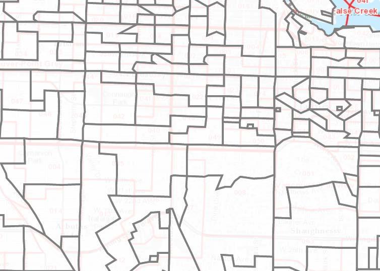
11 Allow for heterogeneity of exposure. Use well defined population groups. Use survey data to help obtain good exposure data. Allow for latency times. Allow for population movement effects. Issues: Best practices (Richardson 1992)


12 Spatial epidemiology Dr. John Snow s Map of Cholera Deaths in the SOHO District of London, 1854


13 1. Spatial epidemiology 2. Environmental hazards 3. Modeling Health Services 4. Identifying health inequalities Major applications for GIS
14 Environmental hazards Hazard Surveillance Hazardous agent present in the environment Route of exposure exists Exposure Surveillance Host exposed to agent Agent reaches target tissue Agent produces adverse effect Outcome Surveillance Effect clinically apparent

15 GIS: Identify causal and mitigating factors Environmental hazards


16 1. Spatial epidemiology 2. Environmental hazards 3. Modeling Health Services 4. Identifying health inequalities Major applications for GIS

17 ARIA (Accessibility/Remoteness Index of Australia) A generic index of accessibility/ remoteness for all populated places in non-metropolitan Australia. A model which allows accessibility to any type of service to be calculated from all populated places in Australia.

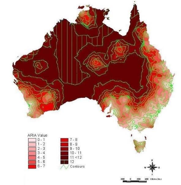
18 AIRA
19 Where do infants and children die in WA? Jane Freemantle, PhD. November 2004 Geographical location Remote Rural Metro. non-aboriginal Aboriginal Mortality Rate / 1000 live births Mortality rate of infants
20 SES and Heart disease Identifying health inequalities: Well-known relationship 25% 50% of observed gradient due to risk factors like smoking, hypertension and diabetes in lower socio-economic groups (Marmot et al.,1997) Access to healthcare (Bosma et al., 2005) Imbalance between workplace demands and economic reward (Lynch et al.,1997) Poor education, lower levels of health literacy, low birth weight (Marmot, 2000) Relationship may vary with gender, with the association thought to be stronger in males (Thurston, 2005) (should we question this?)
21 The Data Number of daily hospital discharges (Y) with Ischemic Heart Disease (IHD) where admission had been via emergency room for 591 postcodes in NSW Every day from July 1, 1996 to June 30, 2001 Males and females 5-year age increments Denominator (N) obtained from census Social disadvantage measured at postal area level using the census-derived SEIFA (Socio-Economic Indexes for Areas) index
22 SEIFA distribution in NSW High values indicate social advantage

23 NSW IHD rates
 What is a")

24 TOC GIS and health geography Major applications for GIS Epidemiology What is health (and how location matters) What is a disease (and how to identify one) Quantifying disease occurrence Incidence vs prevalence Identifying the population Working with small area data
25 What is epidemiology? The study of the distribution and determinants of health and disease-related states in populations, and the application of this study to control health problems. the product of [epidemiology] is research and information and not public health action and implementation (Atwood et al. 1997) epidemiology s full value is achieved only when its contributions are placed in the context of public health action, resulting in a healthier populace. (Koplan et al. 1999) (Source: Rutgers)
26 DESCRIPTIVE Health and disease in the community What? Who? When? Where? What are the health problems of the community? What are the attributes of these illnesses? ANALYTIC Why? What are the causal agents? How many people are affected? What are the attributes of affected persons? How? Over what period of time? Where do the affected people live, work or spend leisure time? Etiology, prognosis and program evaluation By what mechanism do they operate? What factors affect outcome? Epidemiologic approaches
27 What are health and disease? Dorland's Illustrated Medical Dictionary (28th ed.): Health "a state of optimal physical, mental, and social well-being, and not merely the absence of disease and infirmity. Disease "any deviation from or interruption of the normal structure or function of any part, organ, or system (or combination thereof) of the body that is manifested by a characteristic set of symptoms and signs...".
28 What is health Health, as defined in the World Health Organization's Constitution, is "a state of complete physical, mental and social well-being and not merely the absence of disease or infirmity." Health is seen as more than just the absence of disease, and depends upon a complex suite of factors, with location taking the lead. A location is more than just a position within a spatial frame (e.g., on the surface of the Earth or within the human body). Different locations on Earth are usually associated with different profiles: physical, biological, environmental, economic, social, cultural and possibly even spiritual profiles, that do affect and are affected by health, disease and healthcare. (Source: Dr. M. N. Kamel Boulos)
29 Location and health An example of how location matters and carries with it other factors into play: The body weight of infants at birth is one readily available piece of data, and the relationship between low birth-weight and maternal and child health is a continuing line of research. In New York City, Sara McLafferty and Barbara Tempalski have studied the spatial distribution of low birth-weight infants and identified areas in which the number of low birth-weight infants increased sharply during the 1980s. Their results indicated that the rise in low birth-weight was closely linked to women's declining economic status, inadequate insurance coverage and prenatal care, as well as the spread of crack/cocaine.

30 Location and health

31 Location and health
 Quantifying disease occurrence Incidence vs prevalence Identifying the population Working with small area")
32 TOC GIS and health geography Major applications for GIS Epidemiology What is health (and how location matters) What is a disease (and how to identify one) Quantifying disease occurrence Incidence vs prevalence Identifying the population Working with small area data
33 What is disease Manifestional criteria: refer to symptoms, signs, and other manifestations of the condition. Defining a disease in terms of manifestational criteria relies on the proposition that diseases have a characteristic set of manifestations. This defines disease in terms of labeling symptoms. Causal criteria: refer to the etiology (cause) of the condition, which must have been identified in order to be employed. This defines disease in terms of underlying pathological etiology.
34 Manifestational Criteria How do you identify a disease? The Acquired Immunodeficiency Syndrome (AIDS) was initially defined by the CDC in terms of manifestational criteria as a basis for instituting surveillance. The operational definition grouped diverse manifestations Kaposi's sarcoma outside its usual subpopulation, PCP and other opportunistic infections in people with no known basis for immunodeficiency. This was based on similar epidemiologic observations (similar population affected, similar geographical distribution) and a shared type immunity deficit (elevated ratio of T-suppressor to T-helper lymphocytes).


35 Causal Criteria Around 1984 Human Immunodeficiency Virus (HIV, previously called human lymphotrophic virus type III) was discovered and demonstrated to be the causal agent for AIDS. AIDS could then be defined by causal criteria.
36 Challenges with Disease Classifications A single causal agent may have multiple clinical effects. Multiple etiologic pathways may lead to apparently identical manifestations, so that a manifestationally-defined disease entity may include subgroups with differing etiologies (equifinality). Not all persons with the causal agent develop the disease (e.g., Typhoid Mary).
37 Onset of disease Diagnosis of disease Cause-specific mortality Physiologic Underlying Abnormalities Genetic Susceptibility Sub-clinical disease Clinical disease X Environmental & Behavioral Factors (Spatial dependence) The natural history of disease
 What is a")

38 TOC GIS and health geography Major applications for GIS Epidemiology What is health (and how location matters) What is a disease (and how to identify one) Quantifying disease occurrence Incidence versus prevalence Identifying the population Working with small area data


39 To study disease, we need measures of its occurrence. Some measures of disease occurrence Counts Prevalence Incidence Mortality Measures of disease occurrence
40 DESCRIPTIVE Health and disease in the community What? Who? When? Where? What are the health problems of the community? What are the attributes of these illnesses? How many people are affected? What are the attributes of affected persons? Over what period of time? Where do the affected people live, work or spend leisure time? Each of the measures can be calculated for different combinations of What? Who? When? and Where? Each of the W s needs to be defined carefully to get comparable measures across a province or state, a nation, the world. Epidemiologic approaches
41 Incidence and Prevalence Incidence and prevalence measure different aspects of disease occurrence Prevalence Incidence Numerator: Denominator: Measures: All cases, no matter how long diseased All persons in pop Presence of disease Only NEW cases Only persons at risk of disease Risk of disease Most useful: Resource allocation Risk, etiology Etiology: the study of a disease s causes.

 age, sex, race, etc.")
42 Numerator Number of deaths Denominator Number of individuals in population (how defined?) Time interval 1-year: Annual Mortality Rate Specifier (typical to use an annual rate) age, sex, race, etc. Mortality Rate Incidence of death

43 Mortality rates
44 Prevalence numerator case definition AIDS cases, United States Result of new definition 1 st Quarter of 1993: Expansion of surveillance case definition

45 The demi in Epidemiology Understanding population dynamics is crucial to epidemiology. Demography = the study of population dynamics including fertility, mortality and migration Γρεεκ epi demos logy English among people study
 Quantifying disease occurrence Incidence vs prevalence Identifying the population Working with small area")
46 TOC GIS and health geography Major applications for GIS Epidemiology What is health (and how location matters) What is a disease (and how to identify one) Quantifying disease occurrence Incidence vs prevalence Identifying the population Working with small area data

47 Data considerations Developing multi-level models for spatiallycorrelated data requires confidence in the dependent data. Data for disease mapping often consists of disease counts and exposure levels in small adjacent geographical areas. The analysis of disease rates or counts for small areas often involves a trade-off between statistical stability of the estimates and geographic precision.


48 Methodological toolboxes Spatial Analytic Techniques for Medical Geographers (Albert et al., 2000)
 What is a")

49 Summary GIS and health geography Major applications for GIS Epidemiology What is health (and how location matters) What is a disease (and how to identify one) Quantifying disease occurrence Incidence versus prevalence Identifying the population Working with small area data
Jun Tu. Department of Geography and Anthropology Kennesaw State University
 Examining Spatially Varying Relationships between Preterm Births and Ambient Air Pollution in Georgia using Geographically Weighted Logistic Regression Jun Tu Department of Geography and Anthropology Kennesaw
Human Population Dynamics CAPT Embedded Task
 Name Per. Assigned Due Human Population Dynamics CAPT Embedded Task Essential Question: What factors influence population growth? The human population has existed for a little more than 500,000 years.
JOINT STRATEGIC NEEDS ASSESSMENT (JSNA) Key findings from the Leicestershire JSNA and Charnwood summary
 Key findings from the Leicestershire JSNA and Charnwood summary") JOINT STRATEGIC NEEDS ASSESSMENT (JSNA) Key findings from the Leicestershire JSNA and Charnwood summary 1 What is a JSNA? Joint Strategic Needs Assessment (JSNA) identifies the big picture in terms of
JOINT STRATEGIC NEEDS ASSESSMENT (JSNA) Key findings from the Leicestershire JSNA and Charnwood summary 1 What is a JSNA? Joint Strategic Needs Assessment (JSNA) identifies the big picture in terms of
Health and Medical Geography (GEOG 222)
") Spring 2019 Class meets: Tuesdays and Thursdays 12:30-1:45pm Carolina Hall Room 220 Instructor: Michael Emch Email: emch@unc.edu Course Objectives Health and Medical Geography (GEOG 222) This course is
Spring 2019 Class meets: Tuesdays and Thursdays 12:30-1:45pm Carolina Hall Room 220 Instructor: Michael Emch Email: emch@unc.edu Course Objectives Health and Medical Geography (GEOG 222) This course is
Approach to identifying hot spots for NCDs in South Africa
 Approach to identifying hot spots for NCDs in South Africa HST Conference 6 May 2016 Noluthando Ndlovu, 1 Candy Day, 1 Benn Sartorius, 2 Karen Hofman, 3 Jens Aagaard-Hansen 3,4 1 Health Systems Trust,
Mission Geography and Missouri Show-Me Standards Connecting Mission Geography to State Standards
 Module 1: Volcanoes local hazard, global issue Mission Geography and Missouri Show-Me Standards Connecting Mission Geography to State Standards Grades 5-8 Inv Geography for Life State Standard(s) Connection
Spatial Variation in Hospitalizations for Cardiometabolic Ambulatory Care Sensitive Conditions Across Canada
 Spatial Variation in Hospitalizations for Cardiometabolic Ambulatory Care Sensitive Conditions Across Canada CRDCN Conference November 14, 2017 Martin Cooke Alana Maltby Sarah Singh Piotr Wilk Today s
Applications of GIS in Health Research. West Nile virus
 Applications of GIS in Health Research West Nile virus Outline Part 1. Applications of GIS in Health research or spatial epidemiology Disease Mapping Cluster Detection Spatial Exposure Assessment Assessment
Social Vulnerability Index. Susan L. Cutter Department of Geography, University of South Carolina
 Social Vulnerability Index Susan L. Cutter Department of Geography, University of South Carolina scutter@sc.edu Great Lakes and St. Lawrence Cities Initiative Webinar December 3, 2014 Vulnerability The
This report details analyses and methodologies used to examine and visualize the spatial and nonspatial
 Analysis Summary: Acute Myocardial Infarction and Social Determinants of Health Acute Myocardial Infarction Study Summary March 2014 Project Summary :: Purpose This report details analyses and methodologies
Medical GIS: New Uses of Mapping Technology in Public Health. Peter Hayward, PhD Department of Geography SUNY College at Oneonta
 Medical GIS: New Uses of Mapping Technology in Public Health Peter Hayward, PhD Department of Geography SUNY College at Oneonta Invited research seminar presentation at Bassett Healthcare. Cooperstown,
Using Geospatial Methods with Other Health and Environmental Data to Identify Populations
 Using Geospatial Methods with Other Health and Environmental Data to Identify Populations Ellen K. Cromley, PhD Consultant, Health Geographer ellen.cromley@gmail.com Purpose and Outline To illustrate the
Analysis of Longitudinal Data. Patrick J. Heagerty PhD Department of Biostatistics University of Washington
 Analysis of Longitudinal Data Patrick J Heagerty PhD Department of Biostatistics University of Washington Auckland 8 Session One Outline Examples of longitudinal data Scientific motivation Opportunities
The Cultural Landscape: An Introduction to Human Geography, 10e (Rubenstein) Chapter 2 Population
 Chapter 2 Population") The Cultural Landscape: An Introduction to Human Geography, 10e (Rubenstein) Chapter 2 Population 1) One important feature of the world's population with the most significant future implications is that
The Cultural Landscape: An Introduction to Human Geography, 10e (Rubenstein) Chapter 2 Population 1) One important feature of the world's population with the most significant future implications is that
Spotlight on Population Resources for Geography Teachers. Pat Beeson, Education Services, Australian Bureau of Statistics
 Spotlight on Population Resources for Geography Teachers Pat Beeson, Education Services, Australian Bureau of Statistics Population Population size Distribution Age Structure Ethnic composition Gender
Understanding China Census Data with GIS By Shuming Bao and Susan Haynie China Data Center, University of Michigan
 Understanding China Census Data with GIS By Shuming Bao and Susan Haynie China Data Center, University of Michigan The Census data for China provides comprehensive demographic and business information
Extended Follow-Up and Spatial Analysis of the American Cancer Society Study Linking Particulate Air Pollution and Mortality
 Extended Follow-Up and Spatial Analysis of the American Cancer Society Study Linking Particulate Air Pollution and Mortality Daniel Krewski, Michael Jerrett, Richard T Burnett, Renjun Ma, Edward Hughes,
MULTIPLE CHOICE. Choose the one alternative that best completes the statement or answers the question.
 Exam Name MULTIPLE CHOICE. Choose the one alternative that best completes the statement or answers the question. 1) One important feature of the world's population with the most significant future implications
Topic 4: Changing cities
 Topic 4: Changing cities Overview of urban patterns and processes 4.1 Urbanisation is a global process a. Contrasting trends in urbanisation over the last 50 years in different parts of the world (developed,
2011/04 LEUKAEMIA IN WALES Welsh Cancer Intelligence and Surveillance Unit
 2011/04 LEUKAEMIA IN WALES 1994-2008 Welsh Cancer Intelligence and Surveillance Unit Table of Contents 1 Definitions and Statistical Methods... 2 2 Results 7 2.1 Leukaemia....... 7 2.2 Acute Lymphoblastic
Cluster Analysis using SaTScan
 Cluster Analysis using SaTScan Summary 1. Statistical methods for spatial epidemiology 2. Cluster Detection What is a cluster? Few issues 3. Spatial and spatio-temporal Scan Statistic Methods Probability
A Framework for the Study of Urban Health. Abdullah Baqui, DrPH, MPH, MBBS Johns Hopkins University
 This work is licensed under a Creative Commons Attribution-NonCommercial-ShareAlike License. Your use of this material constitutes acceptance of that license and the conditions of use of materials on this
Linkage Methods for Environment and Health Analysis General Guidelines
 Health and Environment Analysis for Decision-making Linkage Analysis and Monitoring Project WORLD HEALTH ORGANIZATION PUBLICATIONS Linkage Methods for Environment and Health Analysis General Guidelines
DISCRETE PROBABILITY DISTRIBUTIONS
 DISCRETE PROBABILITY DISTRIBUTIONS REVIEW OF KEY CONCEPTS SECTION 41 Random Variable A random variable X is a numerically valued quantity that takes on specific values with different probabilities The
INTRODUCTION. In March 1998, the tender for project CT.98.EP.04 was awarded to the Department of Medicines Management, Keele University, UK.
 INTRODUCTION In many areas of Europe patterns of drug use are changing. The mechanisms of diffusion are diverse: introduction of new practices by new users, tourism and migration, cross-border contact,
Using Geographic Information Systems for Exposure Assessment
 Using Geographic Information Systems for Exposure Assessment Ravi K. Sharma, PhD Department of Behavioral & Community Health Sciences, Graduate School of Public Health, University of Pittsburgh, Pittsburgh,
Pumps, Maps and Pea Soup: Spatio-temporal methods in environmental epidemiology
 Pumps, Maps and Pea Soup: Spatio-temporal methods in environmental epidemiology Gavin Shaddick Department of Mathematical Sciences University of Bath 2012-13 van Eeden lecture Thanks Constance van Eeden
Human Health in Arctic Russia: A Concept of National Monitoring Program
 Human Health in Arctic Russia: A Concept of National Monitoring Program By Northwest Public Health Research Center, St. Petersburg in collaboration with the AMAP Human Health Expert Group; Arctic policy
The Cultural Landscape: Introduction to Human Geography Chapter 1 Thinking Geographically Chapter 2 Population
 The Cultural Landscape: Introduction to Human Geography Chapter 1 Thinking Geographically Chapter 2 Population 1) Scale is A) the system used by geographers to transfer locations from a globe to a map.
Applying Health Outcome Data to Improve Health Equity
 Applying Health Outcome Data to Improve Health Equity Devon Williford, MPH, Health GIS Specialist Lorraine Dixon-Jones, Policy Analyst CDPHE Health Equity and Environmental Justice Collaborative Mile High
CHAPTER 2: KEY ISSUE 1 Where Is the World s Population Distributed? p
 CHAPTER 2: KEY ISSUE 1 Where Is the World s Population Distributed? p. 45-49 Always keep your vocabulary packet out whenever you take notes. As the term comes up in the text, add to your examples for the
1Department of Demography and Organization Studies, University of Texas at San Antonio, One UTSA Circle, San Antonio, TX
 Well, it depends on where you're born: A practical application of geographically weighted regression to the study of infant mortality in the U.S. P. Johnelle Sparks and Corey S. Sparks 1 Introduction Infant
Measuring community health outcomes: New approaches for public health services research
 Research Brief March 2015 Measuring community health outcomes: New approaches for public health services research P ublic Health agencies are increasingly asked to do more with less. Tough economic times
GEOGRAPHIC INFORMATION ANALYSIS AND HEALTH INFRASTRUCTURE
 GEOGRAPHIC INFORMATION ANALYSIS AND HEALTH INFRASTRUCTURE Koutelekos J., 1 Photis N.Y., 2 Manetos P. 3 1. R.N, MSc, Educational Nursing Department, G. Children s Hospital «Agia Sophia» Athens, Greece.
Section III: Poverty Mapping Results
 Section III: Poverty Mapping Results Figure 5: Gewog level rural poverty map 58. The most prominent result from the poverty mapping exercise of Bhutan is the production of a disaggregated poverty headcount
Poverty and Hazard Linkages
 Poverty and Hazard Linkages Global Risk Identification Programme Proposal Development Coordination Meeting Friday, 19 May 2006 CIESIN Earth Institute Columbia University www.ciesin.columbia.edu Data Improvements
School of Geography and Geosciences. Head of School Degree Programmes. Programme Requirements. Modules. Geography and Geosciences 5000 Level Modules
 School of Geography and Geosciences Head of School Degree Programmes Graduate Diploma: Dr W E Stephens Health Geography Research Environmental History and Policy (see School of History) M.Res.: M.Litt.:
BIOL 51A - Biostatistics 1 1. Lecture 1: Intro to Biostatistics. Smoking: hazardous? FEV (l) Smoke
 Smoke") BIOL 51A - Biostatistics 1 1 Lecture 1: Intro to Biostatistics Smoking: hazardous? FEV (l) 1 2 3 4 5 No Yes Smoke BIOL 51A - Biostatistics 1 2 Box Plot a.k.a box-and-whisker diagram or candlestick chart
BIOL 51A - Biostatistics 1 1 Lecture 1: Intro to Biostatistics Smoking: hazardous? FEV (l) 1 2 3 4 5 No Yes Smoke BIOL 51A - Biostatistics 1 2 Box Plot a.k.a box-and-whisker diagram or candlestick chart
Unit 6: Development and Industrialization. Day 1: What is development?
 Unit 6: Development and Industrialization Day 1: What is development? What is Development? The process of improving the material conditions of people through the diffusion of knowledge and technology More
Emergent Geospatial Data & Measurement Issues
 CUNY Institute for Demographic Research Emergent Geospatial Data & Measurement Issues Deborah Balk CUNY Institute for Demographic Research (CIDR) & School of Public Affairs, Baruch College City University
C/W Qu: How is development measured? 13/6/12 Aim: To understand how development is typically measured/classified and the pros/cons of these
 C/W Qu: How is development measured? 13/6/12 Aim: To understand how development is typically measured/classified and the pros/cons of these Starter: Comment on this image Did you spot these? Rubbish truck
Chapter Sixteen Population, Urbanization and Environment
 Chapter Sixteen Population, Urbanization and Environment 1 Population Demography is the study of the size, composition, distribution, and changes in human population. Three basic demographic variables
ANALYZING CITIES & POPULATION: POPULATION GEOGRAPHY
 ANALYZING CITIES & POPULATION: POPULATION GEOGRAPHY Population Geography Population Geography study of the number, contribution, and distribution of human populations Demography the study of the characteristics
Neighborhood social characteristics and chronic disease outcomes: does the geographic scale of neighborhood matter? Malia Jones
 Neighborhood social characteristics and chronic disease outcomes: does the geographic scale of neighborhood matter? Malia Jones Prepared for consideration for PAA 2013 Short Abstract Empirical research
Introduction to GIS. Dr. M.S. Ganesh Prasad
 Introduction to GIS Dr. M.S. Ganesh Prasad Department of Civil Engineering The National Institute of Engineering, MYSORE ganeshprasad.nie@gmail.com 9449153758 Geographic Information System (GIS) Information
The Spatial Perspective
 Department of Geography University of California at Santa Barbara GEOGRAPHY 5 MIDTERM REVIEW SHEET The Spatial Perspective - Review all of chapter 1 carefully except for Box 1.B (but do review Box 1.A
Everything is related to everything else, but near things are more related than distant things.
 SPATIAL ANALYSIS DR. TRIS ERYANDO, MA Everything is related to everything else, but near things are more related than distant things. (attributed to Tobler) WHAT IS SPATIAL DATA? 4 main types event data,
Purpose Study conducted to determine the needs of the health care workforce related to GIS use, incorporation and training.
 GIS and Health Care: Educational Needs Assessment Cindy Gotz, MPH, CHES Janice Frates, Ph.D. Suzanne Wechsler, Ph.D. Departments of Health Care Administration & Geography California State University Long
An Introduction to China and US Map Library. Shuming Bao Spatial Data Center & China Data Center University of Michigan
 An Introduction to China and US Map Library Shuming Bao Spatial Data Center & China Data Center University of Michigan Current Spatial Data Services http://chinadataonline.org China Geo-Explorer http://chinageoexplorer.org
Effect Modification and Interaction
 By Sander Greenland Keywords: antagonism, causal coaction, effect-measure modification, effect modification, heterogeneity of effect, interaction, synergism Abstract: This article discusses definitions
University of Lusaka
 University of Lusaka BSPH 315 Health Mapping & GIS Topic: Background of GIS Content: 1. Aim of the course 2. What do you know about GIS? 3. Difference between geographic data and geographic information
CHAPTER 3 POPULATION AND CULTURE SECTION 1: THE STUDY OF HUMAN GEOGRAPHY
 CHAPTER 3 POPULATION AND CULTURE SECTION 1: THE STUDY OF HUMAN GEOGRAPHY THE STUDY OF HUMAN GEOGRAPHY Human geography includes many topics Language Religion Customs Economics Political Systems One particular
CH. 2 POPULATION AND HEALTH
 CH. 2 POPULATION AND HEALTH KNOW age distribution agricultural density arithmetic density Cairo Conference carrying capacity census child mortality rate contraception Cornucopians crude death rate (CDR)
AP HUG REVIEW WELCOME TO 2 ND SEMESTER! Annette Parkhurst, M.Ed. January, 2015
 AP HUG REVIEW WELCOME TO 2 ND SEMESTER! Annette Parkhurst, M.Ed. January, 2015 Movement Globalization Latitude & Elevation Levels of Economic Activities CONNECTIONS Human Geography Human is the geography
THE DESIGN (VERSUS THE ANALYSIS) OF EVALUATIONS FROM OBSERVATIONAL STUDIES: PARALLELS WITH THE DESIGN OF RANDOMIZED EXPERIMENTS DONALD B.
 OF EVALUATIONS FROM OBSERVATIONAL STUDIES: PARALLELS WITH THE DESIGN OF RANDOMIZED EXPERIMENTS DONALD B.") THE DESIGN (VERSUS THE ANALYSIS) OF EVALUATIONS FROM OBSERVATIONAL STUDIES: PARALLELS WITH THE DESIGN OF RANDOMIZED EXPERIMENTS DONALD B. RUBIN My perspective on inference for causal effects: In randomized
THE DESIGN (VERSUS THE ANALYSIS) OF EVALUATIONS FROM OBSERVATIONAL STUDIES: PARALLELS WITH THE DESIGN OF RANDOMIZED EXPERIMENTS DONALD B. RUBIN My perspective on inference for causal effects: In randomized
Geozones: an area-based method for analysis of health outcomes
 Statistics Canada www.statcan.gc.ca Geozones: an area-based method for analysis of health outcomes CIQSS Montreal, Quebec October 19, 2012 Paul A. Peters, PhD Health Analysis Division, Statistics Canada
Spatial Disparities in the Distribution of Parks and Green Spaces in the United States
 March 11 th, 2012 Active Living Research Conference Spatial Disparities in the Distribution of Parks and Green Spaces in the United States Ming Wen, Ph.D., University of Utah Xingyou Zhang, Ph.D., CDC
Brief Glimpse of Agent-Based Modeling
 Brief Glimpse of Agent-Based Modeling Nathaniel Osgood Using Modeling to Prepare for Changing Healthcare Need January 9, 2014 Agent-Based Models Agent-based model characteristics One or more populations
Sampling approaches in animal health studies. Al Ain November 2017
 Sampling approaches in animal health studies Al Ain 13-14 November 2017 Definitions Populations and Samples From a statistical point of view: Population is a set of measurements, that may be finite or
Regionalizing and Understanding Commuter Flows: An Open Source Geospatial Approach
 Regionalizing and Understanding Commuter Flows: An Open Source Geospatial Approach Lorraine Barry School of Natural and Built Environment, Queen's University Belfast l.barry@qub.ac.uk January 2017 Summary
Studying Populations I
 Exercise 1 Human Adaptation (cultural ecology) Discuss how the regional physical geography influenced the development of unique cultural traits in two distinct areas of the world. GRADE DISTRIBUTION 11
Long Island Breast Cancer Study and the GIS-H (Health)
") Long Island Breast Cancer Study and the GIS-H (Health) Edward J. Trapido, Sc.D. Associate Director Epidemiology and Genetics Research Program, DCCPS/NCI COMPREHENSIVE APPROACHES TO CANCER CONTROL September,
Long Island Breast Cancer Study and the GIS-H (Health) Edward J. Trapido, Sc.D. Associate Director Epidemiology and Genetics Research Program, DCCPS/NCI COMPREHENSIVE APPROACHES TO CANCER CONTROL September,
Acknowledgments xiii Preface xv. GIS Tutorial 1 Introducing GIS and health applications 1. What is GIS? 2
 Acknowledgments xiii Preface xv GIS Tutorial 1 Introducing GIS and health applications 1 What is GIS? 2 Spatial data 2 Digital map infrastructure 4 Unique capabilities of GIS 5 Installing ArcView and the
Railway suicide clusters: how common are they and what predicts them? Lay San Too Jane Pirkis Allison Milner Lyndal Bugeja Matthew J.
 Railway suicide clusters: how common are they and what predicts them? Lay San Too Jane Pirkis Allison Milner Lyndal Bugeja Matthew J. Spittal Overview Background Aims Significance Methods Results Conclusions
Population Research Center (PRC) Oregon Population Forecast Program
 Oregon Population Forecast Program") Population Research Center (PRC) Oregon Population Forecast Program 2013 Oregon League of Cities Conference Risa S. Proehl Jason R. Jurjevich, Ph.D. Population Research Center (PRC) Population Research
Population Research Center (PRC) Oregon Population Forecast Program 2013 Oregon League of Cities Conference Risa S. Proehl Jason R. Jurjevich, Ph.D. Population Research Center (PRC) Population Research
Population 24/7. David Martin, University of Southampton
 Population 24/7 David Martin, University of Southampton Demographics User Group 18 March 2011 Presentation overview Acknowledgement: Samantha Cockings and Samuel Leung; ESRC award RES-062-23-181 Small
INTRODUCTION TO HUMAN GEOGRAPHY. Chapter 1
 INTRODUCTION TO HUMAN GEOGRAPHY Chapter 1 What Is Human Geography? The study of How people make places How we organize space and society How we interact with each other in places and across space How we
AS Population Change Question spotting
 AS Change Question spotting Changing rate of growth How the rate of growth has changed over the last 100 years Explain the reasons for these changes Describe global or national distribution. Study the
On the Use of the Bross Formula for Prioritizing Covariates in the High-Dimensional Propensity Score Algorithm
 On the Use of the Bross Formula for Prioritizing Covariates in the High-Dimensional Propensity Score Algorithm Richard Wyss 1, Bruce Fireman 2, Jeremy A. Rassen 3, Sebastian Schneeweiss 1 Author Affiliations:
2011 Clendening Summer Fellowship Proposal. Describing the Patient Experience Using Geographic Information Systems
 2011 Clendening Summer Fellowship Proposal Describing the Patient Experience Using Geographic Information Systems Introduction The following proposal outlines my project for a 2011 Clendening Summer Fellowship.
Disaggregation according to geographic location the need and the challenges
 International Seminar On United Nations Global Geospatial Information Management Disaggregation according to geographic location the need and the challenges 6 th 7 th November 2018 Tribe Hotel, Nairobi,
M e d i c a l P s y c h o l o g y U n i t, D e p a r t m e nt of C l i n i c a l N e u r o s c i e n c e s a n d M e n t a l H e a l t h Fa c u l t y
 R. Fonseca; M. Figueiredo-Braga M e d i c a l P s y c h o l o g y U n i t, D e p a r t m e nt of C l i n i c a l N e u r o s c i e n c e s a n d M e n t a l H e a l t h Fa c u l t y of M e d i c i n e,
GIS in Locating and Explaining Conflict Hotspots in Nepal
 GIS in Locating and Explaining Conflict Hotspots in Nepal Lila Kumar Khatiwada Notre Dame Initiative for Global Development 1 Outline Brief background Use of GIS in conflict study Data source Findings
GeoHealth Applications Platform ESRI Health GIS Conference 2013
 GeoHealth Applications Platform ESRI Health GIS Conference 2013 Authors Thomas A. Horan, Ph.D. Professor, CISAT Director April Moreno Health GeoInformatics Ph.D. Student Brian N. Hilton, Ph.D. Clinical
SPACE-TIME ACCESSIBILITY MEASURES FOR EVALUATING MOBILITY-RELATED SOCIAL EXCLUSION OF THE ELDERLY
 SPACE-TIME ACCESSIBILITY MEASURES FOR EVALUATING MOBILITY-RELATED SOCIAL EXCLUSION OF THE ELDERLY Izumiyama, Hiroshi Institute of Environmental Studies, The University of Tokyo, Tokyo, Japan Email: izumiyama@ut.t.u-tokyo.ac.jp
Identifying Gaps in Health Service Provision: GIS Approaches
 Identifying Gaps in Health Service Provision: GIS Approaches Errol Bamford, Graeme Hugo Errol Bamford 6th National Rural Health Conference Canberra, Australian Capital Territory, 4-7 March 2001 Identifying
Application of Indirect Race/ Ethnicity Data in Quality Metric Analyses
 Background The fifteen wholly-owned health plans under WellPoint, Inc. (WellPoint) historically did not collect data in regard to the race/ethnicity of it members. In order to overcome this lack of data
Assessing Social Vulnerability to Biophysical Hazards. Dr. Jasmine Waddell
 Assessing Social Vulnerability to Biophysical Hazards Dr. Jasmine Waddell About the Project Built on a need to understand: The pre-disposition of the populations in the SE to adverse impacts from disaster
Technical Track Session I: Causal Inference
 Impact Evaluation Technical Track Session I: Causal Inference Human Development Human Network Development Network Middle East and North Africa Region World Bank Institute Spanish Impact Evaluation Fund
Faculty of Earth Sciences, Department of Cartography, Remote Sensing and GIS, Nicolaus Copernicus University, Lwowska Str. 1, Toruń, Poland
 The Impact of Multidimensional Process of Society Pauperisation on the Global Disease Diffusion - an Analysis of the Problem with the Use of a Cartographic Method of the Research Agnieszka Pilarska, Zenon
Mediation Analysis for Health Disparities Research
 Mediation Analysis for Health Disparities Research Ashley I Naimi, PhD Oct 27 2016 @ashley_naimi wwwashleyisaacnaimicom ashleynaimi@pittedu Orientation 24 Numbered Equations Slides at: wwwashleyisaacnaimicom/slides
THE DATA REVOLUTION HAS BEGUN On the front lines with geospatial data and tools
 THE DATA REVOLUTION HAS BEGUN On the front lines with geospatial data and tools Slidedoc of presentation for MEASURE Evaluation End of Project Meeting Washington DC May 22, 2014 John Spencer Geospatial
How Usable are Current GIS Maps?: Communicating Emergency Preparedness to Urban Populations
 How Usable are Current GIS Maps?: Communicating Emergency Preparedness to Urban Populations Christina Zarcadoolas PhD, Jennefer Boyer MPH, Arthi Krishnaswami MA, Andrea Rothenberg, MS, LCSW Mount Sinai
OCR 2008 AS and A level Geography Specification Mapping Guide
 OCR 2008 AS and A level Geography Specification Mapping Guide Contents Introduction Error! Bookmark not defined. Specification map: 2008 OCR AS and A level Geography 3 What's new? 10 Introduction This
Fighting Cholera With Maps
 Fighting Cholera With Maps Adapted from World Geography by Alan Backler and Stuart Lazarus; taken from Directions in Geography J? Preview of Main Ideas Geographic Themes."0 Five hundred people, all from
Modelling Accessibility to General Hospitals in Ireland
 Modelling Accessibility to General Hospitals in Ireland Stamatis Kalogirou 1,*, Ronan Foley 2 1. National Centre for Geocomputation, John Hume Building, NUI Maynooth, Maynooth, Co. Kildare, Ireland, Tel:
Pathways. Pathways through the Geography Major
 Pathways through the Major majors may structure their course selections around a sub-field of. Pathways are suggestions for classes in, in related disciplines, and skills training. Each pathway includes
Measuring Disaster Risk for Urban areas in Asia-Pacific
 Measuring Disaster Risk for Urban areas in Asia-Pacific Acknowledgement: Trevor Clifford, Intl Consultant 1 SDG 11 Make cities and human settlements inclusive, safe, resilient and sustainable 11.1: By
GEOGRAPHY YEAR 11 ATAR 2019 COURSE OUTLINE
 GEOGRAPHY YEAR 11 ATAR 2019 COURSE OUTLINE Geography ATAR Year 11 Semester 1 Unit 1 Natural and ecological hazards 1 3 Geographical skills Mapping skills identify and interpret a variety of topographic
Globally Estimating the Population Characteristics of Small Geographic Areas. Tom Fitzwater
 Globally Estimating the Population Characteristics of Small Geographic Areas Tom Fitzwater U.S. Census Bureau Population Division What we know 2 Where do people live? Difficult to measure and quantify.
Spatiotemporal Analysis of Urban Traffic Accidents: A Case Study of Tehran City, Iran
 Spatiotemporal Analysis of Urban Traffic Accidents: A Case Study of Tehran City, Iran January 2018 Niloofar HAJI MIRZA AGHASI Spatiotemporal Analysis of Urban Traffic Accidents: A Case Study of Tehran
Assessment and management of at risk populations using a novel GIS based UK population database tool
 Safety and Security Engineering 203 Assessment and management of at risk populations using a novel GIS based UK population database tool H. Balmforth 1, H. McManus 1 & A. Fowler 2 1 Health and Safety Laboratory,
Spatial Analysis 1. Introduction
 Spatial Analysis 1 Introduction Geo-referenced Data (not any data) x, y coordinates (e.g., lat., long.) ------------------------------------------------------ - Table of Data: Obs. # x y Variables -------------------------------------
Exploring the Association Between Family Planning and Developing Telecommunications Infrastructure in Rural Peru
 Exploring the Association Between Family Planning and Developing Telecommunications Infrastructure in Rural Peru Heide Jackson, University of Wisconsin-Madison September 21, 2011 Abstract This paper explores
Population Profiles
 U N D E R S T A N D I N G A N D E X P L O R I N G D E M O G R A P H I C C H A N G E MAPPING AMERICA S FUTURES, BRIEF 6 2000 2010 Population Profiles Atlanta, Las Vegas, Washington, DC, and Youngstown Allison
This table connects the content provided by Education Perfect to the NSW Syllabus.
 Education Perfect Geography provides teachers with a wide range of quality, engaging and innovative content to drive positive student learning outcomes. Designed by teachers and written by our in-house
Urban GIS for Health Metrics
 Urban GIS for Health Metrics Dajun Dai Department of Geosciences, Georgia State University Atlanta, Georgia, United States Presented at International Conference on Urban Health, March 5 th, 2014 People,
Impact Evaluation of Rural Road Projects. Dominique van de Walle World Bank
 Impact Evaluation of Rural Road Projects Dominique van de Walle World Bank Introduction General consensus that roads are good for development & living standards A sizeable share of development aid and
What are we like? Population characteristics from UK censuses. Justin Hayes & Richard Wiseman UK Data Service Census Support
 What are we like? Population characteristics from UK censuses Justin Hayes & Richard Wiseman UK Data Service Census Support Who are we? Richard Wiseman UK Data Service / Jisc Justin Hayes UK Data Service
POPULATION CHARACTERISTICS IN SOLAPUR DISTRICT
 CHAPTER- III POPULATION CHARACTERISTICS IN SOLAPUR DISTRICT 3.1 INTRODUCTION 3.2 THE GROWTH OF POPULATION IN SOLAPUR DISTRICT 3.3 SPATIAL PATTERN OF GROWTH OF POPULATION IN SOLAPUR DISTRICT 3.4 BIRTH RATE