Tuesdays at APA: Results of APA s Digital Coast Needs Assessment Survey. Jim Schwab, AICP. American Planning Association
|
|
|
- Dana Powers
- 5 years ago
- Views:
Transcription

1 Tuesdays at APA: Results of APA s Digital Coast Needs Assessment Survey Jim Schwab, AICP American Planning Association
 Results to be posted in APA web based report this summer But you re special so you get a quick preview")
2 Just Tell Us What You Want APA conducted Digital Coast needs assessment survey on Zoomerang (Nov./Dec. 2010) Results to be posted in APA web based report this summer But you re special so you get a quick preview right here!

3 Overview Who Responded Geospatial Capability Big Issues for Planners What Planners Need Communication
4 Who Responded ROLES (CURRENT OR PAST) Professional Planner (PUBLIC) Professional Planner (PRIVATE) Academic Planning Commissioner Land Use Attorney Other
5 Who Responded (cont) COAST (CURRENT OR PAST) East Coast (Atlantic) West Coast (Pacific) Great Lakes Gulf of Mexico Pacific Islands Arctic Caribbean Sea
6 Who Responded (cont) PUBLIC AGENCY (Current or Past) Municipality County Region/Metropolitan Area State Federal Tribal Multi State Other
7 Geospatial Capability: Use Proficiency (% of Respondents) Expert Advanced Intermediate Introductory Not Familiar
8 Geospatial Capability: Use Proficiency (Great Lakes Region) EXPERT RESPONDENTS 4% ADVANCED RESPONDENTS 20% Total: ADVANCED or EXPERT : 24% INTERMEDIATE RESPONDENTS 50% AT LEAST INTERMEDIATE 74% INTRODUCTORY 24% NOT FAMILIAR 3%
9 Geospatial Capability: Use Frequency (% of Respondents) Always Frequently Occasionally Seldom Never Don't Know
10 Geospatial Capability: Use Frequency (Great Lakes Region) ALWAYS ORGANIZATIONS 25% AT LEAST FREQUENTLY ORGANIZATIONS 75% AT LEAST OCCASIONALLY ORGANIZATIONS 87% SELDOM 7% NEVER 4% DON T KNOW 2%

11 Geospatial Capability: Capacity % Respondents Agree/Strongly Agree their Organization:
12 Big Issues for Planners: TOP TEN Ranked by % Respondents Citing High or Very High Priority 1. Land Use Planning/Growth Management (86%) 2. Conservation (72%) 3. Economic Development (71%) 4. Flooding/Inundation/Storm Surge (68%) 5. Ground Transportation (67%) 6. Infrastructure/Utilities Development (67%) 7. Sustainability (63%) 8. Recreation & Tourism (61%) 9. Public Access (61%) 10. Hazard Management (60%)
13 TOP TEN Issues for Great Lakes Planners: Ranked by % Respondents Citing High or Very High Priority 1. Land Use Planning/Growth Management (90%) 2. Economic Development (80%) 3. Conservation (76%) 4. Recreation & Tourism (71%) 5. Waterfront and Brownfield Redevelopment (70%) 6. Public Access (70%) 7. Sustainability (69%) 8. Ground Transportation (68%) 9. Infrastructure/Utilities Development (66%) 10. Energy/Alternative Energy Development (56%)
14 Regional TOP TEN Issues Ranked by % Respondents Citing High or Very High Priority Climate Change Impacts Arctic (75%); Caribbean (67%) Coastal Storms Gulf of Mexico (73%); Atlantic Southeast (72%); Caribbean (66%); Arctic (55%) Cultural and Heritage Resource Management Pacific Islands (76%); Mid Atlantic (71%); West Coast (66%) Energy/Alternative Energy Development Great Lakes (56%) Habitat Systems Restoration and Monitoring Pacific Islands (65%); West Coast (62%) Marine Transportation Arctic (65%) Protected Species Management Caribbean (67%) Sea Level Rise/Lake Level Change Pacific Islands (65%) Shoreline Change Management Pacific Islands (69%) Waterfront and Brownfield Redevelopment Great Lakes (70%); Atlantic Northeast (69%)
15 What Planners Need: Data Top Five in each Category Ranked by % Respondents
16 What Planners Need: Tools Top Five Ranked by % Respondents Citing High or Very High Importance 1.Impervious Surface Analysis Tool (69%) 2. Coastal County Snapshots (62%) 3. Hazards U.S. Multi Hazard (HAZUS MH) (55%) 4. Nonpoint Source Pollution & Erosion Comparison Tool (55%) 5. Landscape Fragmentation Tool (54%)
17 What Great Lakes Planners Need: Tools Top Five Ranked by % Respondents Citing High or Very High Importance 1. Impervious Surface Analysis Tool (71%) 2. Nonpoint Source Pollution & Erosion Comparison Tool (62%) 3. Landscape Fragmentation Tool (58%) 4. C CAP Land Cover Atlas (57%) 5. Coastal County Snapshots (53%)
18 Communicating with Users: Easy or Difficult? (Great Lakes Regional Highlights) VERY OR SOMEWHAT EASY 14% HIGHEST Pacific Islands (41%) LOWEST Atlantic Northeast (14%) VERY OR SOMEWHAT DIFFICULT 31% HIGHEST Caribbean (40%) LOWEST Pacific Islands (14%)
19 Communication: Challenges % Respondents Citing Primary Challenges Communicating with Decision Makers about Planning Do not have challenges communicating with decision makers Other Planning department is not involved in the issue Scientific or technical complexity of the issue Low political priority/lack of concern Fear of intruding on property rights Lack of immediacy or urgency connected with the issue Competition between diverse community interests and values
20 Communication: Useful Media % Respondents Citing Useful Media when Communicating with Decision Makers about Planning Not Applicable Other Social media (e.g., Twitter, Facebook, LinkedIn, Government TV Videos Time series data in graphic format Local news media (newspapers, radio, TV, etc.) Visualization tools (CanVis, Coastal Flood Memos and reports E mail Mapping tools (electronic) Slide shows (e.g. Power Point) Maps (printed)
21 APA Contact Information Jim Schwab, AICP; Manager, APA Hazards Planning Research Center Chicago office: 205 N. Michigan Ave., Suite 1200 Chicago IL Web:


22 NOAA Great Lakes Climate Needs Assessment Tuesdays at APA July 19, 2011 Chicago, IL Click to add title.. Heather Elmer Old Woman Creek National Estuarine Research Reserve - Ohio DNR Wildlife

23 NERRS (pronounced NEERS)


24 National Programs of the Reserve System System-wide Monitoring Program Identify and track short-term variability and long-term changes in the integrity and biodiversity of estuarine ecosystems. Competitive Research Programs Graduate Research Fellowship program NERRS Science Collaborative Coastal Training Program Better informed decision-making to improve coastal stewardship K-12 Estuarine Education Program (KEEP) Enhance people s ability and willingness to make informed decisions and take responsible actions that affect coastal communities and ecosystems

25 Why assess needs? Information should be tailored to user needs, provided at space and timescales to support decision making, communicated clearly, and accompanied by decision support tools that allow exploration of alternative pathways 1. 1 National Research Council, America s Climate Choices Informing an Effective Response to Climate Change
26 Needs Synthesis Cross cutting needs Communication, Coordination, and Collaboration Data Integration and Information Distribution Climate planning may be taking place across departments in a municipality or county but fragmented, e.g. stormwater planning, emergency management Final report chrept.html


27 Data Collection Interviews: 15 Focus groups: 2 Regions represented: States: NY, OH, MI, MN, WI, IL, Tribal Lake Basins: Erie, Ontario, Huron, Superior, Michigan
28 Preliminary Results Awareness and understanding of potential climate change impacts is variable Cross cutting issues and concerns Uncertainty of impacts, how to plan, deciding which projects to fund Coordination across departments, i.e., emergency response capacity Political agendas as possible barrier to implementing needed changes Economic impacts on variety of sectors including tourism, fisheries, recreational boating, shipping
29 What's hard is that people are going to ask the inevitable question what am I planning for? More rain? Less rain? More snow? less snow? Stormwater manager
30 The beaches, the quality of the beaches are important for our citizens but also for visitors tourism. If you don t have quality beaches that has a negative impact in terms of people s perception. - City Planner
31 People have their missions and they re just following it down without realizing that they can get more of their missions accomplished by helping other people to accomplish their missions, if we are all working together whether it s federal, state, or local level. County Agency Director
32 Online Survey 22 questions to assess Awareness, knowledge, skills Planning efforts Needs for training, information and tools Perceived barriers and benefits Preferred training formats Disseminated through NERRS, Great Lakes Coastal Program, and Sea Grant stakeholder networks and listserves 784 respondents, 644 in Great Lakes watershed

33

34

35

36
37 Your Climate Planning Barriers Funding, staff time, lack of political and public support, uncertainty about impacts, rate and amount, and management options Benefits Improved quality of life for future generations, improved environmental quality, a more secure water supply, conserving habitat for wildlife, reducing human health and safety risks, and protecting public infrastructure
38 Your Climate Planning Needs What information do you need? Planning Financial assistance and incentives, planning examples and lessons learned, potential impacts locally, economic costs and benefits, assessment of community vulnerability Impacts Economy, ecosystems, land use, nonpoint source pollution, public health, shorelines, recreation, and stormwater infrastructure How do you want to access information? One day intermediate workshops, fact sheets, websites, short introductory presentations


 433 4601 Duluth, MN September")

39 Climate Workshops Building planning capacity for Great Lakes coastal communities Cleveland, OH August 10 Contact Heather Elmer (419) Duluth, MN September 13 Green Bay, WI September 22 Contact Patrick Robinson (920)
40 Who Should Attend? Planners and other professionals land use, public health, stormwater, emergency preparedness, and natural resource management Workshop includes Climate change impacts in the Great Lakes region Planning processes and strategies Tools, data, and resources Regional examples of climate planning Stakeholder engagement strategies

41 Building Bridges with Climate Change Workshops Participatory Processes The Best Available Climate Science and Natural Science Information Economic Research and Socio-economic Considerations Vulnerability Assessment and Adaptation Planning Training Builds a Bridge to Improved Climate Readiness

42 Questions? Heather Elmer Old Woman Creek National Estuarine Research Reserve Patrick Robinson Lake Superior National Estuarine Research Reserve

43 Tools for Great Lakes Planners in NOAA s Digital Coast Heather Stirratt NOAA Coastal Services Center
44


45 Climate Change Adaptation U.S. Global Change Research Program Report 2009:

46 Let s Take a Look Around


47 Elevation Data on Digital Coast Enables direct download of coastal elevation data Delivers custom elevation products to the user


48 Great Lakes Bathymetric Lidar U.S. Environmental Protection Agency Great Lakes Restoration Initiative Collected 900 linear kilometers of bathymetric lidar on Lake Superior Filling data gaps based on the basin wide elevation inventory Required extensive stakeholder input on priorities

49 Great Lakes Land Use Source: Gertens Landscaping (MN)

 Designed to help improve understanding of linkages between land change and the environment")
50 The Coastal Change Analysis Program (C CAP) National coastal land cover and change mapping program Inventory of intertidal areas, wetlands, and adjacent uplands, produced or updated every five years Consistent, accurate products through standard data and methods Coastal expression of the National Land Cover Database (NLCD) Designed to help improve understanding of linkages between land change and the environment Kennebunkport, ME


51 C CAP Coastal Land Atlas


52 Coastal County Snapshots: Now Available

53 Digital Coast Training

54 Digital Coast In Action Success Stories We Love Them Buffalo River Project Analysis results highlighted in blue show priority areas for wetlands restoration or creation
55 For More Information Visit or Contact Heather Stirratt (952)


56 CanVis: Visualization Software for Coastal Communities

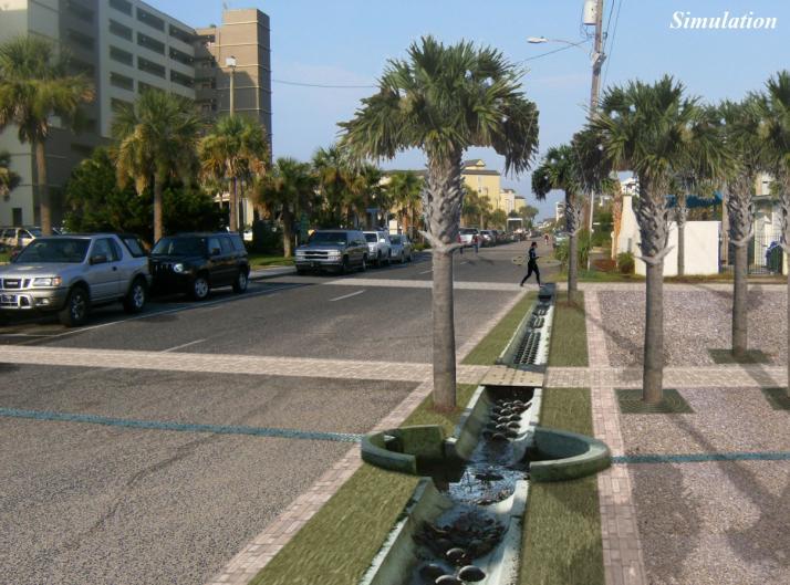
57 CanVis Software U.S. Department of Agriculture (USDA) Forest Service USDA Natural Resources Conservation Service
58 Software Options Factors 2D or 3D Cost Expertise Required Time Required CanVis (level demonstrated) 2D Free None Low Adobe, Paintshop Pro, GIMP 2D Low to medium Medium Low to medium Community Viz, Sketch Up, Visual Nature Studio, Maya 2D or 3D Low to very high High to very high High ArcGIS (ArcScene) requires spatial analyst 2D or 3D High to very high High to very high High Source: CanVis Visual Simulation Guide


59 The Base Image

60 CanVis Software Interface Menu Icons Toolbars Dropdown menu or tab Base image Object


61 CanVis in Action Original object photograph Extracted object Image with extracted object Background image


62 Benefits of Visualization Provides a window into the future Presents alternative futures side by side and poses what if questions Flexibility Easy to engage with stakeholders Stakeholders can recognize their community easier Simulation Environmental Science and Policy, Vol. 8, 2005, S.R.J. Sheppard, Visualizing Climate Change: Theoretical Frameworks, pages 637 to 654.


63 Visualization: Can It Really Change Behaviors? Different imagery stimulates different responses 3 D visualizations led to more cognitive responses but no actual change Photo realistic visualizations led to more behavioral change responses Would this apply to other coastal issues and topics? Environmental Science and Policy, Vol. 8, 2005, S.R.J. Sheppard, Visualizing Climate Change: Theoretical Frameworks, pages 637 to 654.


64 Number of Comments and References to Information Elder Adult Young Adult Maps Simulations The Impact of Imagery Resource management issues presented to community increased dialogue was obtained when using visualizations Seen across multiple demographics Very powerful when both methods are combined Graph: John Lewis, CALP, UBC. Courtesy of Cheam Band, BC.

65 Past Projects and Visualizations Using CanVis
66

67 Simulation

68

69 Simulation

70

71 Simulation

72


73
74 Imagery - Sean Hoelscher and City of North Myrtle Beach Planning and Development Department

75 Simulation Imagery - Sean Hoelscher and City of North Myrtle Beach Planning and Development Department

76 Simulation Imagery - Sean Hoelscher and City of North Myrtle Beach Planning and Development Department
77 Image courtesy live.maps.com
78 Image courtesy live.maps.com


79 Simulation Simulation Simulation

80

81 Coastal Objects
82 Contact Information and Resources Chris Haynes (843) CanVis Website Monthly Virtual Workshop 1:00 4:00 PM Eastern 3 rd Wednesday of every month Now worth 3.0 CM credits for the American Planning Association!
The Coastal Change Analysis Program and the Land Cover Atlas. Rebecca Love NOAA Office for Coastal Management
 The Coastal Change Analysis Program and the Land Cover Atlas Rebecca Love NOAA Office for Coastal Management Natural Infrastructure = Greater Resilience NOAA C-CAP Regional Land Cover and Change coast.noaa.gov/digitalcoast/data/ccapregional
Introducing the. a partnership of
 Introducing the a partnership of Background Need for online atlas identified by managers and researchers to make coastal data available Shoreline data Ocean and coastal resources Sea-level rise potential
Preliminary Vulnerability Assessment of Coastal Flooding Threats - Taylor County, Florida
 Preliminary Vulnerability Assessment of Coastal Flooding Threats - Taylor County, Florida North Central Florida Regional Planning Council Northeast Florida Regional Council April 28, 2016 BACKGROUND This
ICAN Great Lakes 2010 Workshop
 ICAN Great Lakes 2010 Workshop Chris Cortina Maryland s Chesapeake & Coastal Program MD Department of Natural Resources Maryland s Coastal Atlas: What is it? The Coastal Atlas is an online mapping and
3/29/11. Why bother with tools? Incorporating Decision Support Tools into Climate Adaptation Planning. A Simplified Planning Process
 Incorporating Decision Support Tools into Climate Adaptation Planning Why bother with tools? Tools don t eliminate complexity but they can help deal with it" Tools can:"! Help incorporate science into
Urban Climate Resilience
 Urban Climate Resilience in Southeast Asia Partnership Project Introduction Planning for climate change is a daunting challenge for governments in the Mekong Region. Limited capacity at the municipal level,
NOAA s OCM: Services, tools and collaboration opportunities & Puerto Rico s NE Marine Corridor as a case study
 NOAA s OCM: Services, tools and collaboration opportunities & Puerto Rico s NE Marine Corridor as a case study Dr. Antares Ramos Álvarez NOAA s Office of Coastal Management September 15 th, 2016 Conservation
Population Trends Along the Coastal United States:
 Coastal Trends Report Series Population Trends Along the Coastal United States: 1980-2008 U.S. Department of Commerce National Oceanic and Atmospheric Administration National Ocean Service Assessing the
United States Multi-Hazard Early Warning System
 United States Multi-Hazard Early Warning System Saving Lives Through Partnership Lynn Maximuk National Weather Service Director, Central Region Kansas City, Missouri America s s Weather Enterprise: Protecting
Global Environment Facility - Integrating Watershed & Coastal Areas Management (GEF-IWCAM): Andros Demonstration Site
: Andros Demonstration Site") Global Environment Facility - Integrating Watershed & Coastal Areas Management (GEF-IWCAM): Andros Demonstration Site Coastal Aquifer Management in Small Island Developing States of the Caribbean: Challenges
Global Environment Facility - Integrating Watershed & Coastal Areas Management (GEF-IWCAM): Andros Demonstration Site Coastal Aquifer Management in Small Island Developing States of the Caribbean: Challenges
Spatial Data Availability Energizes Florida s Citizens
 NASCIO 2016 Recognition Awards Nomination Spatial Data Availability Energizes Florida s Citizens State of Florida Agency for State Technology & Department of Environmental Protection Category: ICT Innovations
Jim Fox. copyright UNC Asheville's NEMAC
 Decisions and System Thinking Jim Fox November, 2012 1 UNC Asheville s s NEMAC National Environmental Modeling and Analysis Center Applied Research and technology development on integration of environmental
Brian D. George. GIMS Specialist Ohio Coastal Atlas Project Coordinator and Cartographer. Impacts and Outcomes of Mature Coastal Web Atlases
 Ohio Coastal Atlas Project Brian D. George GIMS Specialist Ohio Coastal Atlas Project Coordinator and Cartographer Ohio Department of Natural Resources Office of Coastal Management Sandusky, OH Impacts
Rainfall-River Forecasting: Overview of NOAA s Role, Responsibilities, and Services
 Dr. Thomas Graziano Chief Hydrologic Services Division NWS Headquarters Steve Buan Service Coordination Hydrologist NWS North Central River Forecast Center Rainfall-River Forecasting: Overview of NOAA
A TOOLKIT FOR MARINE SPATIAL PLANNING Version: 17 July, 2009
 A TOOLKIT FOR MARINE SPATIAL PLANNING Version: 17 July, 2009 NEED FOR MARINE SPATIAL PLANNING The health of marine ecosystems is declining, and use conflicts in the marine environment are increasing, in
Arctic ecosystem services: TEEB Arctic Scoping study. Alexander Shestakov WWF Global Arctic Programme 3 December Arctic Biodiversity Congress
 Arctic ecosystem services: TEEB Arctic Scoping study Alexander Shestakov WWF Global Arctic Programme 3 December 20143 Arctic Biodiversity Congress Content 1. Project design 2. Approach 3. Challenges and
ACTION PLAN FOR WORLD HERITAGE IN LATIN AMERICA AND THE CARIBBEAN ( )
") Annex ACTION PLAN FOR WORLD HERITAGE IN LATIN AMERICA AND THE CARIBBEAN (2014-2024) The current Regional Action Plan for Latin America and the Caribbean for 2014-2024 has been elaborated by the State Parties
Annex ACTION PLAN FOR WORLD HERITAGE IN LATIN AMERICA AND THE CARIBBEAN (2014-2024) The current Regional Action Plan for Latin America and the Caribbean for 2014-2024 has been elaborated by the State Parties
Application #: TEXT
 TOWN OF FORT MYERS BEACH 2008 PROPOSED COMPREHENSIVE PLAN AMENDMENTS Application #: 2008-13-TEXT Description: Modify the Coastal Management and Future Land Use Elements to reflect the state s new definition
TOWARDS CLIMATE-RESILIENT COASTAL MANAGEMENT: OPPORTUNITIES FOR IMPROVED ICZM IN BELIZE
 TOWARDS CLIMATE-RESILIENT COASTAL MANAGEMENT: OPPORTUNITIES FOR IMPROVED ICZM IN BELIZE CHANTALLE SAMUELS Coastal Zone Management Authority and Institute The Caribbean Community Climate Change Centre VULNERABILITY
WELCOME & INTRODUCTION
 MPA Management Capacity Building Training Module 1: WELCOME & INTRODUCTION Participants Distinguished Guests Welcome Site Overviews of MPAs represented Overview of Training Program What are Today s Objectives?
Mapping Maine s Working Waterfront: for Our Heritage and Economy
 Mapping Maine s Working Waterfront: for Our Heritage and Economy Abstract Mapping Maine s Working Waterfronts is a collaborative project led by the Island Institute that inventories the state s current
Framework on reducing diffuse pollution from agriculture perspectives from catchment managers
 Framework on reducing diffuse pollution from agriculture perspectives from catchment managers Photo: River Eden catchment, Sim Reaney, Durham University Introduction This framework has arisen from a series
Climate Change and Stormwater. Daniel Brown, Research Associate, GLISA
 Climate Change and Stormwater Daniel Brown, Research Associate, GLISA Global Trends and Regional Trends Global trends are more certain than regional trends. Natural variability plays a larger role at the
Tools for Climate Change Adaptation Planning
 Adaptation base for Planning Tool (ADAPT) CRiSTAL (Community-based Risk Screening Tool Adaptation and Livelihoods) NOAA CSC Coastal Inundation Toolkit NOAA CSC Roadmap Ecosystem-Based Managment Tools Network
Arctic Spatial Data Infrastructure Enabling Access to Arctic Location-Based Information
 Arctic Spatial Data Infrastructure Enabling Access to Arctic Location-Based Information Arctic SDI Side Event Co-Chairs: Arvo Kokkonen Arctic SDI Board Chair & Director General, National Land Survey of
Virginia Shoreline Mapping Tools
 Virginia Shoreline Mapping Tools December 15, 2017 Karen Duhring Center for Coastal Resources Management Virginia Institute of Marine Science College of William & Mary Virginia Shoreline Mapping Tools
Implementing the Sustainable Development Goals: The Role of Geospatial Technology and Innovation
 Fifth High Level Forum on UN Global Geospatial Information Management Implementing the Sustainable Development Goals: The Role of Geospatial Technology and Innovation 28-30 November 2017 Sheraton Maria
Introduction: The Gulf of Mexico Alliance. The Gulf GAME project MERMAid and PHINS Results & Conclusions What s next? Examples
 AAG Las Vegas March 25, 2009 Introduction: Ocean governance and Ecosystem-Based Management The Gulf of Mexico Alliance Habitat Identification and Characterization The Gulf GAME project MERMAid and PHINS
2018/1 The integration of statistical and geospatial information. The Regional Committee of UN-GGIM: Americas:
 The following are the conclusions and recommendations of the Regional Committee of the United Nations on Global Geospatial Information Management for the Americas, during its Fifth Session, Thursday 8
A Regional Database Tracking Fire Footprint Each Year within the South Atlantic Region: Current Database Description and Future Directions
 A Regional Database Tracking Fire Footprint Each Year within the South Atlantic Region: Current Database Description and Future Directions Last Updated on September 30, 2018 Contributors: NatureServe,
Climate Risk Visualization for Adaptation Planning and Emergency Response
 Climate Risk Visualization for Adaptation Planning and Emergency Response NCR Flood Fact Finding Workshop Ricardo Saavedra ricardo@vizonomy.com Social Media, Mobile, and Big Data St. Peter s Basilica,
Positioning the Pacific: NOAA s Geospatial Activities. Juliana Blackwell, Director NOAA s National Geodetic Survey March 6, 2012
 Positioning the Pacific: NOAA s Geospatial Activities Juliana Blackwell, Director NOAA s National Geodetic Survey March 6, 2012 A Common Problem of the Early 19 th Century 1807 President Thomas Jefferson
GIS-Based Sediment Quality Database for the St. Louis River Area of Concern (AOC): Overview Presentations and Demonstration
: Overview Presentations and Demonstration") GIS-Based Sediment Quality Database for the St. Louis River Area of Concern (AOC): Overview Presentations and Demonstration Judy L. Crane 1 and Dawn E. Smorong 2 1 Minnesota Pollution Control Agency, St.
GIS-Based Sediment Quality Database for the St. Louis River Area of Concern (AOC): Overview Presentations and Demonstration Judy L. Crane 1 and Dawn E. Smorong 2 1 Minnesota Pollution Control Agency, St.
Marine Spatial Planning: A Tool for Implementing Ecosystem-Based Management
 Marine Spatial Planning: A Tool for Implementing Ecosystem-Based Management Steven Murawski, Ph.D., Ecosystem Goal Team Lead National Oceanic and Atmospheric Administration NOAA November 16, 2009 1 To
Environmental Response Management Application
 Environmental Response Management Application Coastal Response Research Center Nancy Kinner, Michele Jacobi, Rob Braswell, Kurt Schwehr & Amy Merten RRT III May 14, 2008 1 Talk Outline Overview of Center
Statewide Topographic Mapping Program
 Statewide Topographic Mapping Program February 28, 2018 www.dotd.la.gov Outline Purpose of the Statewide Topographic Mapping Program History Breakdown of R.S. 48:36 - Topographic Mapping Statewide Topographic
Land Cover Classification Mapping & its uses for Planning
 Land Cover Classification Mapping & its uses for Planning What is Land Cover Classification Mapping? Examples of an actual product Why use Land Cover Classification Mapping for planning? Possible uses
Doug Kluck NOAA Kansas City, MO National Center for Environmental Information (NCEI) National Integrated Drought Information System (NIDIS)
 National Integrated Drought Information System (NIDIS)") National Integrated Drought Information System (NIDIS) for the Missouri River Basin Drought Early Warning Information System (DEWS) & Runoff Trends in the Missouri Basin & Latest Flood Outlook Doug Kluck
National Integrated Drought Information System (NIDIS) for the Missouri River Basin Drought Early Warning Information System (DEWS) & Runoff Trends in the Missouri Basin & Latest Flood Outlook Doug Kluck
Coastal Response Research Center. Nancy Kinner University of New Hampshire (UNH) Michele Jacobi NOAA ORR. September 27, 2007
 Michele Jacobi NOAA ORR. September 27, 2007") Coastal Response Research Center Nancy Kinner University of New Hampshire (UNH) Michele Jacobi NOAA ORR September 27, 2007 1 Coastal Response Research Center (CRRC) CRRC is partnership between NOAA s Office
Coastal Response Research Center Nancy Kinner University of New Hampshire (UNH) Michele Jacobi NOAA ORR September 27, 2007 1 Coastal Response Research Center (CRRC) CRRC is partnership between NOAA s Office
EcoServ-GIS. EcoServ GIS Stage I. Why EcoServ GIS? 17/12/2012
 EcoServ-GIS Ecosystem Services Mapping: A Wildlife Trust GIS Toolkit to map ecosystem services at a county scale Dr Jonathan Winn Living Landscape Coordinator Durham Wildlife Trust Dr Chloe Bellamy Ecosystem
Lorna V Inniss, Ph.D SAGE Workshop, New York City
 Lorna V Inniss, Ph.D SAGE Workshop, New York City 2014-05-21 Why me? The globally recognized success of the Barbados ICZM programme has generated requests for technical assistance and CD from many Governments
Geographic Information Infrastructure and Policy Framework for Sustainable Mountain Development in the Hindu Kush-Himalayas
 Geo SMART ASIA 2017 22-24 August, Kualalampur Geographic Information Infrastructure and Policy Framework for Sustainable Mountain Development in the Hindu Kush-Himalayas Basanta Shrestha, Director Strategic
Exploring GIS Potential for Northwestern Ontario Land Information Ontario
 Exploring GIS Potential for Northwestern Ontario Land Information Ontario May 13, 2015 The LIO Vision LIO Vision: That all geographic information about Ontario is fully integrated and accessible LIO Goal:
Presentation Outline. Project Overview. Sea Level Rise Assessment & Decision Tools. Community Engagement. Tina Whitman, Friends of the San Juans
 Healthy Beaches for People & Fish Sea Level Rise Adaptation Tools for San Juan County, WA Tina Whitman & Andrea MacLennan December 10, 2015 Presentation Outline Project Overview Tina Whitman, Friends of
Switching to AQA from Edexcel: Draft Geography AS and A-level (teaching from September 2016)
") Switching to AQA from Edexcel: Draft Geography AS and A-level (teaching from September 2016) If you are thinking of switching from OCR to AQA (from September 2016), this resource is an easy reference guide.
Switching to AQA from Edexcel: Draft Geography AS and A-level (teaching from September 2016) If you are thinking of switching from OCR to AQA (from September 2016), this resource is an easy reference guide.
Aboriginal communities strengthen governance with location-based tools in the 21st century
 Aboriginal communities strengthen governance with location-based tools in the 21st century Today, Aboriginal communities are taking advantage of the geomatics technologies that underpin popular online
Climate Change: How it impacts Canadians and what we can do to slow it down.
 Climate Change: How it impacts Canadians and what we can do to slow it down. Lesson Overview This lesson takes stock of how climate change has already affected Canadians in geographic, economic, and cultural
PROPOSED UNESCO FUNDY BIOSPHERE RESERVE
 OVERVIEW PROPOSED UNESCO FUNDY BIOSPHERE RESERVE NEW BRUNSWICK, CANADA NOMINATION DOCUMENT April 10, 2007 The United Nations Educational, Scientific and Cultural Organization (UNESCO) Man and the Biosphere
ICAN Great Lakes Workshop
 Washington Coastal latlas ICAN Great Lakes Workshop September 13 15, 15 2010 Current Washington Coastal Atlas http://www.ecy.wa.gov/programs/sea/sma/atlas_home.html 1 st version of WA Coastal Atlas was
USGS National Geospatial Program Understanding User Needs. Dick Vraga National Map Liaison for Federal Agencies July 2015
 + USGS National Geospatial Program Understanding User Needs Dick Vraga National Map Liaison for Federal Agencies July 2015 + Topics 2 Background Communities of Use User Surveys National Map Liaisons Partnerships
Joanne N. Halls, PhD Dept. of Geography & Geology David Kirk Information Technology Services
 Joanne N. Halls, PhD Dept. of Geography & Geology David Kirk Information Technology Services Geographic Information Systems manage and analyze data to solve spatial problems. Real World Abstraction Analysis
OUR COASTAL FUTURES. A Strategy for the Sustainable Development of the World s Coasts.
 OUR COASTAL FUTURES A Strategy for the Sustainable Development of the World s Coasts www.futureearthcoasts.org Iqaluit, Nunavut, Canada. Photo by Don Forbes Coastal zones are the frontline in our global
Belfairs Academy GEOGRAPHY Fundamentals Map
 YEAR 12 Fundamentals Unit 1 Contemporary Urban Places Urbanisation Urbanisation and its importance in human affairs. Global patterns of urbanisation since 1945. Urbanisation, suburbanisation, counter-urbanisation,
Coastal Inundation Forecasting Demonstration Project CIFDP. Flood Forecasting Initiative-Advisory Group (FFI-AG 3), Geneva, 5-7 Dec, 2017
, Geneva, 5-7 Dec, 2017") Coastal Inundation Forecasting Demonstration Project CIFDP Flood Forecasting Initiative-Advisory Group (FFI-AG 3), Geneva, 5-7 Dec, 2017 Coastal Flooding & Vulnerable Populations Coastal populations are
Coastal Inundation Forecasting Demonstration Project CIFDP Flood Forecasting Initiative-Advisory Group (FFI-AG 3), Geneva, 5-7 Dec, 2017 Coastal Flooding & Vulnerable Populations Coastal populations are
RETA 6422: Mainstreaming Environment for Poverty Reduction Category 2 Subproject
 RETA 6422: Mainstreaming Environment for Poverty Reduction Category 2 Subproject A. Basic Data 1. Subproject Title: Poverty-Environment Mapping to Support Decision Making 2. Country Director: Adrian Ruthenberg
UN-GGIM: Strengthening Geospatial Capability
 Fifth Plenary Meeting of UN-GGIM: Europe Brussels, 6-7 June 2018 UN-GGIM: Strengthening Geospatial Capability Walking the talk to leave no one behind Greg Scott, UN-GGIM Secretariat Environmental Statistics
Overview of Methods. Terrestrial areas that are most important for conservation Conservation
 Overview of Methods The goal of the Western Lake Erie Coastal Conservation Vision project (WLECCV) is to define where we should be working locally to optimally achieve regional conservation impact. The
Table G - 6. Mitigation Actions Identified for Implementation by the City of Kent ( ) (From Wilkin County Master Mitigation Action Chart)
 (From Wilkin County Master Mitigation Action Chart)") Table G - 6. Actions Identified by the () (From Master Action Chart) Multi-Hazard Plan, 2017 Action Comments 5 All-Hazards Local Planning & Regulations Update the Operations Plan on an annual basis. Work
Table G - 6. Actions Identified by the () (From Master Action Chart) Multi-Hazard Plan, 2017 Action Comments 5 All-Hazards Local Planning & Regulations Update the Operations Plan on an annual basis. Work
Remote Sensing and Spatial Analysis (RSSA)
") MESM Track Remote Sensing and Spatial Analysis (RSSA) Dr. Y.Q. Wang (Track Chair) http://nrs.uri.edu/people/faculty/wang.html Remote Sensing and Spatial Analysis Remote sensing, GIS, GPS and their applications
MESM Track Remote Sensing and Spatial Analysis (RSSA) Dr. Y.Q. Wang (Track Chair) http://nrs.uri.edu/people/faculty/wang.html Remote Sensing and Spatial Analysis Remote sensing, GIS, GPS and their applications
An Environmental Profile of the Island of Jost Van Dyke, British Virgin Islands
 An Environmental Profile of the Island of Jost Van Dyke, British Virgin Islands Executive Summary including Little Jost Van Dyke, Sandy Cay, Green Cay and Sandy Spit This publication was made possible
Randall W. Parkinson, Ph.D., P.G. Institute of Water and Environment Florida International University
 An Update on Adaptation Action Activities Undertaken Since Completion of the City of Satellite Beach (FL) Vulnerability Assessment to Rising Seas (2010) Randall W. Parkinson, Ph.D., P.G. Institute of Water
NOAA Nautical Charts and Coastal and Marine Spatial Planning. Meredith Westington Chief Geographer NOAA/NOS/Office of Coast Survey
 NOAA Nautical Charts and Coastal and Marine Spatial Planning Meredith Westington Chief Geographer NOAA/NOS/Office of Coast Survey Ocean Policy Task Force What is CMSP? A comprehensive, adaptive, integrated,
Towards international cooperation in the development of Marine Spatial Plans for the North Pacific: economic, social, and environmental dimensions
 Towards international cooperation in the development of Marine Spatial Plans for the North Pacific: economic, social, and environmental dimensions A.V. Sereda, V.B. Lobanov V.I. Il ichev Pacific Oceanological
CLLD Cooperation OFFER
 Title of the proposed project (English) CLLD Cooperation OFFER PARKS PROTECTION III - Management, Protection and Economic Development in Protected Areas Type of project (select as many as you want) Cooperation
National Disaster Management Centre (NDMC) Republic of Maldives. Location
 Republic of Maldives. Location") National Disaster Management Centre (NDMC) Republic of Maldives Location Country Profile 1,190 islands. 198 Inhabited Islands. Total land area 300 sq km Islands range b/w 0.2 5 sq km Population approx.
National Disaster Management Centre (NDMC) Republic of Maldives Location Country Profile 1,190 islands. 198 Inhabited Islands. Total land area 300 sq km Islands range b/w 0.2 5 sq km Population approx.
Applying GIS to Coastal Management in Cork Harbour: the Corepoint experience
 Applying GIS to Coastal Management in Cork Harbour: the Corepoint experience Kathrin Köpke University College Cork, Ireland Thematic Conference: THE WATERFRONT MANAGEMENT AND GI (IT), 14 th -18 th November
FINDINGS OF THE ARCTIC METEOROLOGY SUMMIT
 FINDINGS OF THE ARCTIC METEOROLOGY SUMMIT 2018 WWW.FMI.FI CHAIR S SUMMARY: 1 2 3 We need to be curious to explore the known unknowns. Meteorology is an elemental part of international collaboration in
Geographical knowledge and understanding scope and sequence: Foundation to Year 10
 Geographical knowledge and understanding scope and sequence: Foundation to Year 10 Foundation Year 1 Year 2 Year 3 Year 4 Year 5 Year 6 Year level focus People live in places Places have distinctive features
Land Use Methods & Metrics Development Outcome
 Quarterly Progress Meeting November 15, 2018 Land Use Methods & Metrics Development Outcome Peter Claggett, USGS LUWG Coordinator Through the Chesapeake Bay Watershed Agreement, the Chesapeake Bay Program
GIS Data and Technology to Support Transportation & MPO Decision-Making & Planning. using an Eco-Logical* Approach within the Kansas City Region
 GIS Data and Technology to Support Transportation & MPO Decision-Making & Planning using an Eco-Logical* Approach within the Kansas City Region Authors (in alphabetical order): Tom Gerend, Tom Jacobs,
Summary of Available Datasets that are Relevant to Flood Risk Characterization
 Inter-Agency Characterization Workshop February 25-27, 2014 USACE Institute for Water Resources, Alexandria, VA, IWR Classroom Summary of Available Datasets that are Relevant to Characterization National
UPTAKE AND PATHWAYS OF COASTAL ADAPTATION PROCESSES IN AUSTRALIA
 2015 Effect of Climate Change on the World's Oceans - Santos, Brazil UPTAKE AND PATHWAYS OF COASTAL ADAPTATION PROCESSES IN AUSTRALIA COASTAL COLLABORATION CLUSTER: MEETING COASTAL CHALLENGES Débora M.
Impact Policies Enabling Value Enhancement of Geospatial Information in Canadian Economy and Society
 1 Impact Policies Enabling Value Enhancement of Geospatial Information in Canadian Economy and Society May 26, 2015 Prashant Shukle, Director General Canada Centre for Mapping and Earth Observation Increased
Disaster Management & Recovery Framework: The Surveyors Response
 Disaster Management & Recovery Framework: The Surveyors Response Greg Scott Inter-Regional Advisor Global Geospatial Information Management United Nations Statistics Division Department of Economic and
Mapping Coastal Change Using LiDAR and Multispectral Imagery
 Mapping Coastal Change Using LiDAR and Multispectral Imagery Contributor: Patrick Collins, Technical Solutions Engineer Presented by TABLE OF CONTENTS Introduction... 1 Coastal Change... 1 Mapping Coastal
Alaska Ocean Observing System 101 Anchorage, Alaska
 Alaska Ocean Observing System 101 Anchorage, Alaska Molly McCammon, Director Alaska Ocean Observing System (AOOS) A Regional Observing System within the Integrated Ocean Observing System www.aoos.org IOOS
STATE GEOGRAPHIC INFORMATION DATABASE
 STATE GEOGRAPHIC INFORMATION DATABASE Data Information and Knowledge Management STATE GEOGRAPHIC INFORMATION DATABASE EXECUTIVE SUMMARY Utah has developed one of the most comprehensive statewide GIS resources
Geological Survey of Canada Lands and Minerals Sector Natural Resources Canada OneGeology, June 2018
 Geological Survey of Canada Lands and Minerals Sector Natural Resources Canada OneGeology, June 2018 Geological Survey of Canada Mission The Geological Survey of Canada provides public geoscience knowledge
Oregon APA Legal Issues Workshop December 7, Tricia Sears, DLCD With information from Bill Burns, DOGAMI
 Oregon APA Legal Issues Workshop December 7, 2018 Tricia Sears, DLCD With information from Bill Burns, DOGAMI How this Topic Arrived WE FREQUENTLY HEAR CONCERNS ABOUT LIABILITY AND TAKINGS. Current federal
The Research Agenda of the Wisconsin Coastal Atlas
 The Research Agenda of the Wisconsin Coastal Atlas David Hart GIS Specialist University of Wisconsin Sea Grant Institute International Coastal Atlas Network Workshop 4 Trieste, Italy Tuesday, November
Marine Spatial Planning, a Norwegian user case NSHC33
 Marine Spatial Planning, a Norwegian user case NSHC33 Marine Spatial Management Tool Support the marine spatial planning process with updated and reliable geospatial information Marine management is important
Tools for Climate Change Adaptation Planning
 Adaptation base for Planning Tool (ADAPT) An online database that guides users through ICLEI's 5 Milestones for Climate Adaptation planning framework. ADAPT walks you through the process of assessing your
GALVESTON BAY RSM Moving toward an Integrated, Cooperative, and Holistic Approach to Estuarine Sediments
 GALVESTON BAY RSM Moving toward an Integrated, Cooperative, and Holistic Approach to Estuarine Sediments RAE Conference 2010 Larry A. Wise Moffatt & Nichol RSM is a system-based approach for collaboratively
Heather Schlosser Army Corps of Engineers Coastal Studies Group August 28, 2008
 Got sand? Regional Sediment Management in Orange County Heather Schlosser Army Corps of Engineers Coastal Studies Group August 28, 2008 Regional Sediment Management Regional sediment management recognizes
The Tampa Bay Catastrophic Plan Presentation to CFGIS Users Group FDOT District 5 Urban Offices - Orlando July 30, 2010
 The Tampa Bay Catastrophic Plan Presentation to CFGIS Users Group FDOT District 5 Urban Offices - Orlando July 30, 2010 Brady Smith Senior Planner Tampa Bay Regional Planning Council Introduction Recent
Assessment and valuation of Ecosystem Services for decision-makers
 Assessment and valuation of Ecosystem Services for decision-makers An introduction to the ARIES approach Ferdinando Villa *, Ken Bagstad Gary Johnson, Marta Ceroni *Basque Center for Climate Change, Bilbao,
Application of Geospatial Technology in an Emergency Management Academic Program
 Application of Geospatial Technology in an Emergency Management Academic Program Author Edwin Leachman Visiting Assistant Professor Department of Emergency Administration and Management Arkansas Tech University
OCR 2008 AS and A level Geography Specification Mapping Guide
 OCR 2008 AS and A level Geography Specification Mapping Guide Contents Introduction Error! Bookmark not defined. Specification map: 2008 OCR AS and A level Geography 3 What's new? 10 Introduction This
Realizing benefits of Spatial Data Infrastructure A user s perspective from Environment Agency - Abu Dhabi
 Realizing benefits of Spatial Data Infrastructure A user s perspective from Environment Agency - Abu Dhabi Anil Kumar Director, Environment Information Management 26 April 2012 Geospatial World Forum,
PUBLIC HEALTH ASSOCIATION OF AUSTRALIA Strategic Plan
 PUBLIC HEALTH ASSOCIATION OF AUSTRALIA Strategic Plan March 2017 20 Napier Close Deakin ACT Australia 2600 PO Box 319 Curtin ACT Australia 2605 Table of Contents Introduction... 2 Vision for a healthy
A Comprehensive Inventory of the Number of Modified Stream Channels in the State of Minnesota. Data, Information and Knowledge Management.
 A Comprehensive Inventory of the Number of Modified Stream Channels in the State of Minnesota Data, Information and Knowledge Management Glenn Skuta Environmental Analysis and Outcomes Division Minnesota
Subject Area: Geography
 Long Term Planning Overview Key Stage 3 Subject Area: Geography Academic : 08-9 7 Assessment Your Island Home the physical and human geography of the UK and will investigate weather patterns, population
Improving Sub-Seasonal to Seasonal Prediction at NOAA
 Improving Sub-Seasonal to Seasonal Prediction at NOAA Dr. Louis W. Uccellini Director, National Weather Service NOAA Assistant Administrator for Weather Services July 13, 2016 Congressional Briefing Value
The World Bank BZ Marine Conservation and Climate Adaptation (P131408)
") Public Disclosure Authorized LATIN AMERICA AND CARIBBEAN Belize Environment & Natural Resources Global Practice Recipient Executed Activities Investment Project Financing FY 2015 Seq No: 2 ARCHIVED on
Public Disclosure Authorized LATIN AMERICA AND CARIBBEAN Belize Environment & Natural Resources Global Practice Recipient Executed Activities Investment Project Financing FY 2015 Seq No: 2 ARCHIVED on
Vulnerability Assessment of Coastal Flooding Threats St. Joseph Bay to Apalachee Bay Coastline - Draft
 Vulnerability Assessment of Coastal Flooding Threats St. Joseph Bay to Apalachee Bay Coastline - Draft INTRODUCTION Located on the Gulf coast of Florida, the Apalachee Bay Region includes four coastal
Land Accounts - The Canadian Experience
 Land Accounts - The Canadian Experience Development of a Geospatial database to measure the effect of human activity on the environment Who is doing Land Accounts Statistics Canada (national) Component
DEPARTMENT OF GEOLOGY AND MINERAL INDUSTRIES WAYS & MEANS SUBCOMMITTEE ON NATURAL RESOURCES MARCH 2, 2017
 DEPARTMENT OF GEOLOGY AND MINERAL INDUSTRIES WAYS & MEANS SUBCOMMITTEE ON NATURAL RESOURCES MARCH 2, 2017 1 ABOUT DOGAMI AGENCY MISSION, VISION & GOALS 2 Lidar image of a stream network along the Umpqua
Applied Geoscience and Technology Division SOPAC. Joy Papao, Risk Information Systems Officer
 Joy Papao, Risk Information Systems Officer Secretariat of the Pacific Community SPC 22 Pacific Island States Head office in Noumea, New Caledonia 2 Regional offices (Pohnpei and Honiara) 600 staff 9 Technical
The Economics of Ecosystems and Biodiversity on Bonaire. The value of citizens in the Netherlands for nature in the Caribbean
 The Economics of Ecosystems and Biodiversity on Bonaire The value of citizens in the Netherlands for nature in the Caribbean 2 The Economics of Ecosystems and Biodiversity on Bonaire The value of citizens
Northrop Grumman Concept Paper
 Northrop Grumman Concept Paper A Comprehensive Geospatial Web-based Solution for NWS Impact-based Decision Support Services Glenn Higgins April 10, 2014 Northrop Grumman Corporation Information Systems