Global Environment Facility - Integrating Watershed & Coastal Areas Management (GEF-IWCAM): Andros Demonstration Site
|
|
|
- Caroline Angelica Barnett
- 6 years ago
- Views:
Transcription


: Andros")


1 Global Environment Facility - Integrating Watershed & Coastal Areas Management (GEF-IWCAM): Andros Demonstration Site Coastal Aquifer Management in Small Island Developing States of the Caribbean: Challenges and New Directions St. Kitts & Nevis October 11-12, 2010

2 700 islands &cays 80 km east of Florida, 80 km NE of Cuba Total land area - 13,939 square kilometers 3,542 km of coast Entire country is considered coastal Extremely flat highest elev 63 m The Bahamas
 Small clusters of communities east coast Largest groundwater resevoir")
3 ANDROS ISLAND The largest island in The Bahamas 100miles long and 45 miles wide population of 8,000 (2005 est.) Small clusters of communities east coast Largest groundwater resevoir
4 GEF-IWCAM Andros Project The primary objective of the IWCAM Andros project is to demonstrate active groundwater recharge area protection through the development of a Land and Sea Use Plan
5 GEF-IWCAM Andros Project Objectives Develop a land and sea use plan Develop baseline inventory of land & sea resources Integrated multi-sector approach to GIS Adoption of new technologies & approaches to address water resources Replication of lessons learned and practices


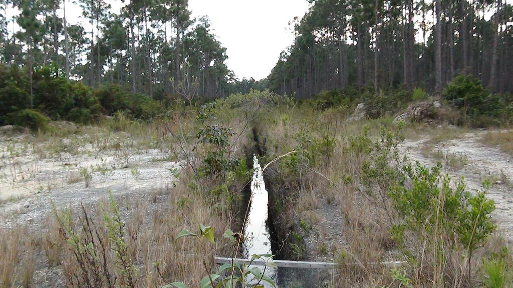
6 Bird Assessment Terrestrial Surveys Land Use/Land Cover
 Bahama Woodstar")
 Great Lizard-Cuckoo,")

7 Popular Birds of Andros Bahama Oriole Andros (only) Bahama Woodstar Bahamas (only) Bahama Yellowthroat Bahamas (only) Great Lizard-Cuckoo, - Andros and Eleuthera Bahama Swallow - Andros, Abaco, Grand Bahama, New Providence
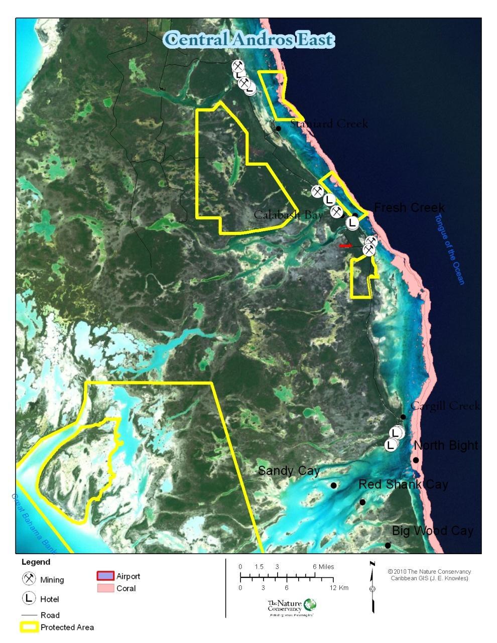

8 Mapping of Biodiversity, Threats & Concerns


9 Economic Valuation of Natural Resources What is the economic impact? How do people make a living off the land and sea? What is the value of the natural resources of Andros?
10 Economic Valuation Results Economic Impact Nature provides income and employment for 80% of Andros; 1,645 full time jobs and 8,000 part time jobs $141 million Fisheries, Harvesting of land crabs, Crafts, Sportsfishing, Nature based tourism, etc Value of Ecosystem Services The net benefit of fresh water on Andros is $3.5 million each year. The habitats on Andros provide an estimated mean of $46,000 per km 2 per year in ecosystem services, such as carbon storage, water supply and recreation

11 Water Conservation Strategy Existing water uses and threats Sector Specific Water Use Water and wastewater management efficiency Recommendations for water conservation on Andros


12 Public Awareness Workshops, Luncheons, Public Meetings (GIS, Economic Valuation & Ecotourism strategy) School Presentations, Poster Competition, Weather Station Installations

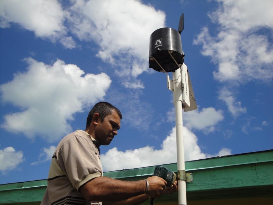
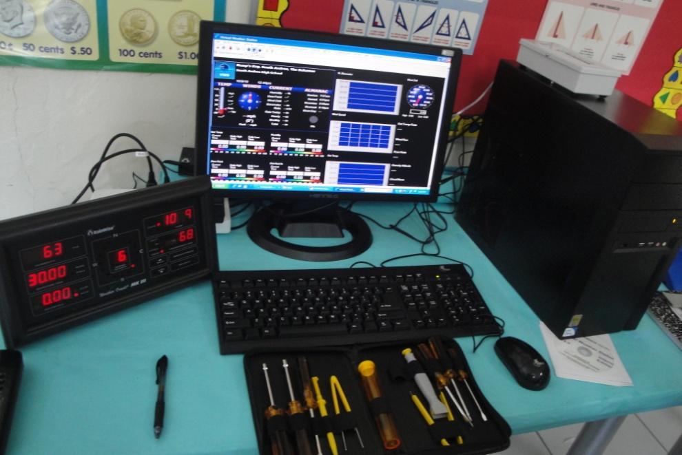
13 Weather Stations

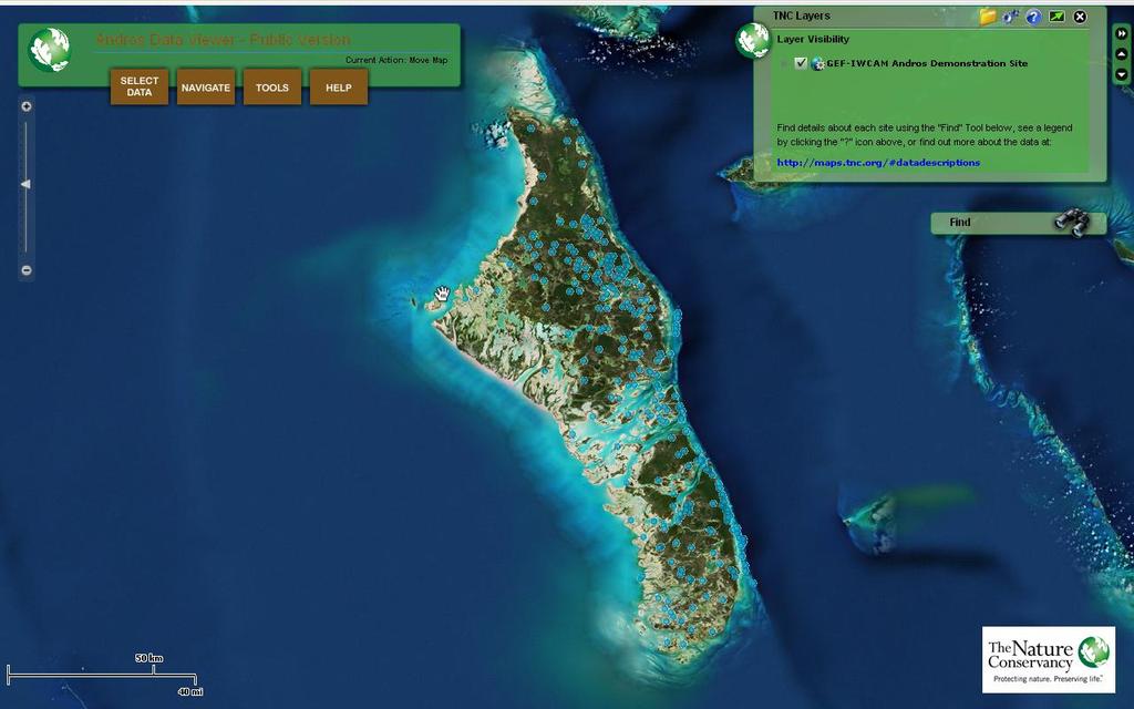
14 Online GIS Web Map
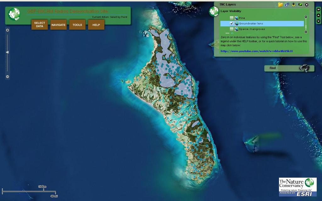
15

16 Project Website

17 Regional Programmes Water and Culture UNESCO-IHP / Project WET Water and Education Programme for the Americas and the Caribbean. Mike Swann from the Bahamas has represented our interests.] Water Balance Map of Arid and Semi-arid Zones. In October-2007 Member States of the Caribbean meet in the Bahamas to finalize the Maps for the Caribbean Territories.
18 Integrated Water Resources Management (IWRM) UNESCO-IHP Phase VII Water Dependencies: Systems under Stress and Societal Responses THEME 1: Adapting to the impacts of global changes on river basins and aquifer systems THEME 2: Strengthening Water Governance for Sustainability THEME 3: Ecohydrology for Sustainability THEME 4: Water and Life Support Systems THEME 5: Water Education for Sustainable Development
19 Regional Activities: Phase VII UNESCO Graphic North Andros Case Study UNESCO Caribbean Water Resource for SID s UNESCO Regional Center for the Development of Water Resources in Caribbean Island States
20 UNESCO Graphic GRAPHIC Groundwater Resources Assessment under the Pressure of Humanity and Climate Change The North Andros Wellfields to be utilized as the project site. Thru UNESCO-IHP activities. The Bahamas shall assist additional Caribbean Territories and Small Island Developing States (SID s) with the management of their groundwater resources.
21 UNESCO GRAPHIC Andros Site Develop and compile a geospatial groundwater database for Andros Island, populate the database with available data, and identify critical data gaps; Design and implement data collection and monitoring networks for the Andros Island fresh groundwater lens to fill identified data gaps through augmentation and enhancement of existing infrastructure Train local personnel in all aspects of the project including Information dissemination and technology transfer to other Caribbean nations
22
23
ASSOCIATION OF CARIBBEAN STATES (ACS / AEC)
") ASSOCIATION OF CARIBBEAN STATES (ACS / AEC) 1 SHOCS (Strengthening Hydrometorological Operations and Services in Caribbean SIDS) The ACS/Finnish Government response to Hydrometorological risk in Caribbean
ASSOCIATION OF CARIBBEAN STATES (ACS / AEC) 1 SHOCS (Strengthening Hydrometorological Operations and Services in Caribbean SIDS) The ACS/Finnish Government response to Hydrometorological risk in Caribbean
Dr. Biliana Cicin-Sain President, Global Ocean Forum 1
 Towards a Sustainable Development Goal on Oceans and Seas: Healthy, Productive and Resilient Oceans and Seas- Prosperous and Resilient Peoples and Communities Dr. Biliana Cicin-Sain President, Global Ocean
5th Caribbean Environmental Forum and Exhibition (CEF 5) Montego Bay, Jamaica June 21-25, 2010
 Montego Bay, Jamaica June 21-25, 2010") 5th Caribbean Environmental Forum and Exhibition (CEF 5) Montego Bay, Jamaica June 21-25, 2010 Watershed Modeling in the Caribbean: Application of Geographic Information Systems (GIS) in the Assessment
5th Caribbean Environmental Forum and Exhibition (CEF 5) Montego Bay, Jamaica June 21-25, 2010 Watershed Modeling in the Caribbean: Application of Geographic Information Systems (GIS) in the Assessment
CLLD Cooperation OFFER
 Title of the proposed project (English) CLLD Cooperation OFFER PARKS PROTECTION III - Management, Protection and Economic Development in Protected Areas Type of project (select as many as you want) Cooperation
Implementing Rio+20: Integrated Planning For Sustainable Coastal Area Management In the Caribbean Region
 Expert Group Meeting Implementing Rio+20: Integrated Planning For Sustainable Coastal Area Management In the Caribbean Region Address by Ronny Jumeau Seychelles Ambassador for Climate change And SIDS Issues
Areas Beyond National Jurisdiction (ABNJ) 2016 Regional Leaders Program. March 22 to April 1, 2016 United Nations, New York
 2016 Regional Leaders Program. March 22 to April 1, 2016 United Nations, New York") Areas Beyond National Jurisdiction (ABNJ) 2016 Regional Leaders Program March 22 to April 1, 2016 United Nations, New York Welcome and Introductions Biliana Cicin-Sain President, Global Ocean Forum Vladimir
Areas Beyond National Jurisdiction (ABNJ) 2016 Regional Leaders Program March 22 to April 1, 2016 United Nations, New York Welcome and Introductions Biliana Cicin-Sain President, Global Ocean Forum Vladimir
Arctic ecosystem services: TEEB Arctic Scoping study. Alexander Shestakov WWF Global Arctic Programme 3 December Arctic Biodiversity Congress
 Arctic ecosystem services: TEEB Arctic Scoping study Alexander Shestakov WWF Global Arctic Programme 3 December 20143 Arctic Biodiversity Congress Content 1. Project design 2. Approach 3. Challenges and
Assessing, Monitoring, and Defending Coral Reefs with GIS
 Assessing, Monitoring, and Defending Coral Reefs with GIS Dr. Rich Snow and Dr. Mary Snow Applied Aviation Sciences Embry-Riddle Aeronautical University Daytona Beach, Florida It is estimated that 60%
How important is to be a Biosphere Reserve of UNESCO? The case of Berlenga Islands (Peniche Portugal)
") How important is to be a Biosphere Reserve of UNESCO? The case of Berlenga Islands (Peniche Portugal) Sérgio Leandro Environmental advisor Township of Peniche (Portugal) Polytecnic Institute of Leiria
How important is to be a Biosphere Reserve of UNESCO? The case of Berlenga Islands (Peniche Portugal) Sérgio Leandro Environmental advisor Township of Peniche (Portugal) Polytecnic Institute of Leiria
Resolution XIII.23. Wetlands in the Arctic and sub-arctic
 13th Meeting of the Conference of the Contracting Parties to the Ramsar Convention on Wetlands Wetlands for a Sustainable Urban Future Dubai, United Arab Emirates, 21-29 October 2018 Resolution XIII.23
An Environmental Profile of the Island of Jost Van Dyke, British Virgin Islands
 An Environmental Profile of the Island of Jost Van Dyke, British Virgin Islands Executive Summary including Little Jost Van Dyke, Sandy Cay, Green Cay and Sandy Spit This publication was made possible
WELCOME & INTRODUCTION
 MPA Management Capacity Building Training Module 1: WELCOME & INTRODUCTION Participants Distinguished Guests Welcome Site Overviews of MPAs represented Overview of Training Program What are Today s Objectives?
Lorna V Inniss, Ph.D SAGE Workshop, New York City
 Lorna V Inniss, Ph.D SAGE Workshop, New York City 2014-05-21 Why me? The globally recognized success of the Barbados ICZM programme has generated requests for technical assistance and CD from many Governments
TOWARDS CLIMATE-RESILIENT COASTAL MANAGEMENT: OPPORTUNITIES FOR IMPROVED ICZM IN BELIZE
 TOWARDS CLIMATE-RESILIENT COASTAL MANAGEMENT: OPPORTUNITIES FOR IMPROVED ICZM IN BELIZE CHANTALLE SAMUELS Coastal Zone Management Authority and Institute The Caribbean Community Climate Change Centre VULNERABILITY
ACRONYMS AREAS COUNTRIES MARINE TERMS
 Natura 2000 ACRONYMS AREAS COUNTRIES MARINE TERMS DEFINITION A European network of protected sites under the European Habitats and Birds Directives, aiming to protect the most valuable and threatened European
16540/14 EE/cm 1 DG E 1A
 Council of the European Union Brussels, 5 December 2014 (OR. en) 16540/14 ENV 965 CULT 139 NOTE From: To: Subject: General Secretariat of the Council Delegations Charter of Rome on Natural and Cultural
HELSINKI COMMISSION Baltic Marine Environment Protection Commission
 HELSINKI COMMISSION Baltic Marine Environment Protection Commission HELCOM RECOMMENDATION 24/10 Adopted 25 June 2003, having regard to Article 20, Paragraph 1 b) of the 1992 Helsinki Convention IMPLEMENTATION
EUSAIR on sea topics from Slovenian perspective
 MINISTRY OF FOREIGN AFFAIRS REPUBLIC OF SLOVENIA EUSAIR on sea topics from Slovenian perspective Mag. Andreja Jerina National Coordinator 4 EU MRS: 270 millions of population 19 MS 12 non MS Sea basin
Biodiversity and Protected Areas Management Project
 Biodiversity and Protected Areas Management Project Technical Advisor ESA region: Selwyn Willoughby Coordinator ESA region: Christine Mentzel FlexiCadastre EMEA Regional User Conference, Cape Town, South
ACTION PLAN FOR WORLD HERITAGE IN LATIN AMERICA AND THE CARIBBEAN ( )
") Annex ACTION PLAN FOR WORLD HERITAGE IN LATIN AMERICA AND THE CARIBBEAN (2014-2024) The current Regional Action Plan for Latin America and the Caribbean for 2014-2024 has been elaborated by the State Parties
Annex ACTION PLAN FOR WORLD HERITAGE IN LATIN AMERICA AND THE CARIBBEAN (2014-2024) The current Regional Action Plan for Latin America and the Caribbean for 2014-2024 has been elaborated by the State Parties
Land Use in the context of sustainable, smart and inclusive growth
 Land Use in the context of sustainable, smart and inclusive growth François Salgé Ministry of sustainable development France facilitator EUROGI vice president AFIGéO board member 1 Introduction e-content+
Naturally. Westport... Wet and Wild...
 Westport... Wet and Wild... Naturally A revitalization concept for the City of Westport and Port of Grays Harbor presented by FOGH (Friends of Grays Harbor), Wildlife Forever of Grays Harbor and other
Key Indicators for Territorial Cohesion & Spatial Planning Stakeholder Workshop - Project Update. 13 th December 2012 San Sebastián, Basque Country
 Key Indicators for Territorial Cohesion & Spatial Planning Stakeholder Workshop - Project Update 13 th December 2012 San Sebastián, Basque Country Key Aims Explore the use of territorial data in developing
Assessing and mapping ecosystem services in a small islands state
 Assessing and mapping ecosystem services in a small islands state Mario V. Balzan Laboratory of Terrestrial Ecology, Institute of Applied Science, MCAST, Malta. E-mail: mario.balzan@mcast.edu.mt SGA Mentoring
Connecting Freshwater to Oceans: Major Questions
 Connecting Freshwater to Oceans: Major Questions Biliana Cicin-Sain Co-Chair Chair and Head of Secretariat, Global Forum on Oceans, Coasts, and Islands Origin of Global Forum Mobilized in 2001 to put oceans,
African Coastal Atlas developments. 10 July 2008 EEA Copenhagen, Denmark
 African Coastal Atlas developments 10 July 2008 EEA Copenhagen, Denmark Africa Overview Africa has approximately 40 000 km of coast across 32 mainland countries and four island states. Africa's coastal
PACIFIC ISLANDS REGIONAL OCEAN POLICY. A healthy Ocean that sustains the livelihoods and aspirations of Pacific Island communities.
 PACIFIC ISLANDS REGIONAL OCEAN POLICY VISION A healthy Ocean that sustains the livelihoods and aspirations of Pacific Island communities. THIS IS OUR OCEAN 1. The care of the ocean is the responsibility
Joanne N. Halls, PhD Dept. of Geography & Geology David Kirk Information Technology Services
 Joanne N. Halls, PhD Dept. of Geography & Geology David Kirk Information Technology Services Geographic Information Systems manage and analyze data to solve spatial problems. Real World Abstraction Analysis
The Role of Data & Information Infrastructures in Supporting Climate Change Adaptation in Latin America & the Caribbean
 The Role of Data & Information Infrastructures in Supporting Climate Change Adaptation in Latin America & the Caribbean Emil A. Cherrington Senior Scientist Water Center for the Humid Tropics of Latin
First Meeting of the Expert Group on Environment Statistics New York, March 2014
 First Meeting of the Expert Group on Environment Statistics New York, 26-28 March 2014 Experiences on the application of the new FDES Anand Sookun asookun@gmail.com Mauritius Contents Mauritius Old FDES
Applied Geoscience and Technology Division SOPAC. Joy Papao, Risk Information Systems Officer
 Joy Papao, Risk Information Systems Officer Secretariat of the Pacific Community SPC 22 Pacific Island States Head office in Noumea, New Caledonia 2 Regional offices (Pohnpei and Honiara) 600 staff 9 Technical
THE SEVILLE STRATEGY ON BIOSPHERE RESERVES
 THE SEVILLE STRATEGY ON BIOSPHERE RESERVES 1 VISION FOR BIOSPHERE RESERVES IN THE 21 ST CENTURY The international Seville Conference on Biosphere Reserves, organised by UNESCO, adopted a two-pronged approach,
IMA s ROLE IN COASTAL AND OCEAN GOVERNANCE IN TRINIDAD AND TOBAGO
 IMA s ROLE IN COASTAL AND OCEAN GOVERNANCE IN TRINIDAD AND TOBAGO Presented by Rahanna Juman, Deputy Director (Ag.) About the Institute of Marine Affairs Institute of Marine Affairs (IMA) was established,
This table connects the content provided by Education Perfect to the NSW Syllabus.
 Education Perfect Geography provides teachers with a wide range of quality, engaging and innovative content to drive positive student learning outcomes. Designed by teachers and written by our in-house
National Disaster Management Centre (NDMC) Republic of Maldives. Location
 Republic of Maldives. Location") National Disaster Management Centre (NDMC) Republic of Maldives Location Country Profile 1,190 islands. 198 Inhabited Islands. Total land area 300 sq km Islands range b/w 0.2 5 sq km Population approx.
National Disaster Management Centre (NDMC) Republic of Maldives Location Country Profile 1,190 islands. 198 Inhabited Islands. Total land area 300 sq km Islands range b/w 0.2 5 sq km Population approx.
Land Accounts - The Canadian Experience
 Land Accounts - The Canadian Experience Development of a Geospatial database to measure the effect of human activity on the environment Who is doing Land Accounts Statistics Canada (national) Component
GENERAL RECOMMENDATIONS. Session 7. Breakout discussion. discuss on regional and interregional. proposals 1. COLLABORATION BETWEEN PROGRAMMES
 Session 7 24 July 2016, 9.00-11.00 Breakout discussion on regional and interregional joint project proposals Mr Shahbaz Khan summarized the two days of presentations and exchanges and requested the participants
SPLAN-Natura Towards an integrated spatial planning approach for Natura th January, 2017 Brussels. Commissioned by DG Environment
 SPLAN-Natura 2000 Towards an integrated spatial planning approach for Natura 2000 Commissioned by DG Environment 17 th January, 2017 Brussels V. Simeonova (Ph.D.) Drivers towards integrating Biodiversity
PROMOTING NATURE CONSERVATION AND SUSTAINABLE AGRICULTURAL DEVELOPMENT IN THE RURAL AREAS OF HONG KONG
 1 PROMOTING NATURE CONSERVATION AND SUSTAINABLE AGRICULTURAL DEVELOPMENT IN THE RURAL AREAS OF HONG KONG Director of Agriculture, Fisheries and Conservation Dr. LEUNG Siu-fai A STONE S THROW AWAY FROM
The Global Fundamental Geospatial Data Themes Journey. April Clare Hadley WG Chair
 The Global Fundamental Geospatial Data Themes Journey April 2018 Clare Hadley WG Chair The Road to here Why Global? Why Geospatial? Why Fundamental? Why Themes? The route we took Where does the road go
ROLE OF SPATIAL PLANNING TOOLS AT MESO-SCALE IN THE MANAGEMENT OF NATURAL RESOURCES, LESSONS LEARNT FROM AFRICAN COUNTRIES
 6th Nov, 2012 ROLE OF SPATIAL PLANNING TOOLS AT MESO-SCALE IN THE MANAGEMENT OF NATURAL RESOURCES, LESSONS LEARNT FROM AFRICAN COUNTRIES Masoom Hamdard Environmental Planning and Assessment for Adaptation
Coastal Viewer Mapping Application:
 Coastal Viewer Mapping Application: MAPPING OF COASTAL PUBLIC PROPERTY, THE COASTAL PROTECTION ZONE BOUNDARIES AND AUDITING OF STRUCTURES ON THE COASTAL PUBLIC PROPERTY 15 May 2014 INTEGRATED COASTAL MANAGEMENT
Establishment of the Hellenic Ecosystem Services Partnership (HESP) research group: Drafting the national agenda for the implementation of the
 research group: Drafting the national agenda for the implementation of the") Establishment of the Hellenic Ecosystem Services Partnership (HESP) research group: Drafting the national agenda for the implementation of the ES concept in Greece Establishment of the Hellenic Ecosystem
Establishment of the Hellenic Ecosystem Services Partnership (HESP) research group: Drafting the national agenda for the implementation of the ES concept in Greece Establishment of the Hellenic Ecosystem
Digital Development of Territories. Pedro Leite Member of the Board of Directors
 Digital Development of Territories Pedro Leite Member of the Board of Directors Digital Development of Territories Pedro Leite Member of the Board of Directors Azores Archipelago 9 islands located in the
GIS Geographical Information Systems. GIS Management
 GIS Geographical Information Systems GIS Management Difficulties on establishing a GIS Funding GIS Determining Project Standards Data Gathering Map Development Recruiting GIS Professionals Educating Staff
MR. George ALEXAKIS, parallel session 3. "Mediterranean Sea Region. laying the conditions. for sustainable growth and jobs"
 parallel session 3 "Mediterranean Sea Region laying the conditions for sustainable growth and jobs" MR. George ALEXAKIS, elected Regional Councillor of Crete, Greece and representative of Crete in CRPM.
SEEA Experimental Ecosystem Accounting
 SEEA Experimental Ecosystem Accounting Sokol Vako United Nations Statistics Division Training for the worldwide implementation of the System of Environmental Economic Accounting 2012 - Central Framework
Management Planning & Implementation of Communication Measures for Terrestrial Natura 2000 Sites in the Maltese Islands Epsilon-Adi Consortium
 Management Planning & Implementation of Communication Measures for Terrestrial Natura 2000 Sites in the Maltese Islands Epsilon-Adi Consortium Briefing Meetings, February 2013 CT3101/2011, MEPA, Malta
Declaration Population and culture
 Declaration Population and culture The ministers of the parties to the Alpine Convention regard the socio-economic and socio-cultural aspects mentioned in Article 2, Paragraph 2, Item a., as being central
Disaster Risk Assessment: Opportunities for GIS and data management with Open DRI
 Disaster Risk Assessment: Opportunities for GIS and data management with Open DRI Jacob Opadeyi Department of Geomatics Engineering and Land Management, The University of the West Indies, St. Augustine,
Regional Flash Flood Guidance and Early Warning System
 WMO Training for Trainers Workshop on Integrated approach to flash flood and flood risk management 24-28 October 2010 Kathmandu, Nepal Regional Flash Flood Guidance and Early Warning System Dr. W. E. Grabs
Subject Area: Geography
 Long Term Planning Overview Key Stage 3 Subject Area: Geography Academic : 08-9 7 Assessment Your Island Home the physical and human geography of the UK and will investigate weather patterns, population
The story of sharing environmental data
 The story of sharing environmental data Kallio, Pyhälahti, Harju, Teiniranta, Lahtinen, Finnish Environment Institute SYKE OKFestival, Finnish Open Data, 18. Sep 2012 Contents Call for environmental knowledge
Putting the U.S. Geospatial Services Industry On the Map
 Putting the U.S. Geospatial Services Industry On the Map December 2012 Definition of geospatial services and the focus of this economic study Geospatial services Geospatial services industry Allow consumers,
Strategic Framework on Geospatial Information and Services for Disasters Relevance for the Americas Region
 Strategic Framework on Geospatial Information and Services for Disasters Relevance for the Americas Region Seventh Session of the Committee of Experts on UN-GGIM Side Event --- UN Headquarters, New York
Marine Spatial Planning in Hellas; Recent Facts and Perspectives
 XXV FIG CONGRESS Engaging the Challenges, Enhancing the Relevance Kuala Lumpur, Malaysia 16 21 June 2014 Marine Spatial Planning in Hellas; Recent Facts and Perspectives Mrs. Chaiditsa BOLANOU Surveying
TOWARDS STRATEGIC SPATIAL PLANNING IN JAMAICA: THE NATIONAL SPATIAL PLAN
 TOWARDS STRATEGIC SPATIAL PLANNING IN JAMAICA: THE NATIONAL SPATIAL PLAN JIEP 5th Biennial Conference on the Environment: Balancing National Development and Environmental Protection June 6, 2011 Jamaica
Georeferencing and Satellite Image Support: Lessons learned, Challenges and Opportunities
 Georeferencing and Satellite Image Support: Lessons learned, Challenges and Opportunities Shirish Ravan shirish.ravan@unoosa.org UN-SPIDER United Nations Office for Outer Space Affairs (UNOOSA) UN-SPIDER
National Adaptation Geo-information System (NAGiS) project in Hungary
 project in Hungary") National Adaptation Geo-information System (NAGiS) project in Hungary Mr. Péter Kajner Hungarian Mining and Geological Survey (MBFSZ) National Adaptation Center Department CGE webinar: Geo-information
National Adaptation Geo-information System (NAGiS) project in Hungary Mr. Péter Kajner Hungarian Mining and Geological Survey (MBFSZ) National Adaptation Center Department CGE webinar: Geo-information
BURGAS CASE STUDY: LAND-SEA INTERACTIONS. Dr. Margarita Stancheva
 BURGAS CASE STUDY: LAND-SEA INTERACTIONS Dr. Margarita Stancheva Name of presentation NEED FOR COHERENCE BETWEEN LAND AND SEA ACTIVITIES Name presenter Burgas is the fourth largest city in Bulgaria and
The Global Statistical Geospatial Framework and the Global Fundamental Geospatial Themes
 The Global Statistical Geospatial Framework and the Global Fundamental Geospatial Themes Sub-regional workshop on integration of administrative data, big data and geospatial information for the compilation
Good Practices in Environment Statistics - the example of Mauritius
 Expert Working Group on the Framework for the Development of Environment Statistics UNSD, New York 8 10 November 2010 Good Practices in Environment Statistics - the by Anand Sookun Central Statistics Office
EABRN, 20 years of History and its Future (East Asia Biosphere Reserve Network)
") EABRN, 20 years of History and its Future (East Asia Biosphere Reserve Network) Choi Jongwon Director, MoE, Republic of Korea Contents 1 Overview and History 2 Key Activities (1) Regional Network Meetings
EABRN, 20 years of History and its Future (East Asia Biosphere Reserve Network) Choi Jongwon Director, MoE, Republic of Korea Contents 1 Overview and History 2 Key Activities (1) Regional Network Meetings
Compact guides GISCO. Geographic information system of the Commission
 Compact guides GISCO Geographic information system of the Commission What is GISCO? GISCO, the Geographic Information System of the COmmission, is a permanent service of Eurostat that fulfils the requirements
INFORMATION RESOURCES FOR MARINE AND AQUATIC SCIENCES RESEARCH IN TRINIDAD AND TOBAGO
 INFORMATION RESOURCES FOR MARINE AND AQUATIC SCIENCES RESEARCH IN TRINIDAD AND TOBAGO Introduction Sharida Hosein The University of the West Indies Campus Libraries St Augustine, Trinidad and Tobago. West
Asia Protected Areas Charter
 資料 3-1 Asia Protected Areas Charter The Asia Challenge Asia is the world s most rapidly growing region as well as one of the most bio-diverse. This dynamic development has led to unprecedented growth,
Experiences on Data and Observational Requirements in the Caribbean
 Experiences on Data and Observational Requirements in the Caribbean UNFCCC Expert Workshop on Methods & Tools and on Data & Observations under the NWP on Impacts, Vulnerability & Adaptation to Climate
National Survey on the Natural Environment of Japan. Hajime Hirosawa Biodiversity Center of Japan Ministry of the Environment (MOE)
") National Survey on the Natural Environment of Japan Hajime Hirosawa Biodiversity Center of Japan Ministry of the Environment (MOE) Biodiversity Center of Japan, MOE Establishment: 1998 Purpose: to encourage
National Survey on the Natural Environment of Japan Hajime Hirosawa Biodiversity Center of Japan Ministry of the Environment (MOE) Biodiversity Center of Japan, MOE Establishment: 1998 Purpose: to encourage
Marine Spatial Planning: A Tool for Implementing Ecosystem-Based Management
 Marine Spatial Planning: A Tool for Implementing Ecosystem-Based Management Steven Murawski, Ph.D., Ecosystem Goal Team Lead National Oceanic and Atmospheric Administration NOAA November 16, 2009 1 To
Cross-border Maritime Spatial Plan for the Black sea - Romania and Bulgaria project
 Cross-border Maritime Spatial Plan for the Black sea - Romania and Bulgaria project in Romania and Bulgaria Plan Presentation A first step in the management of the marine areas of Romania and Bulgaria
Carpathians Unite mechanism of consultation and cooperation for implementation of the Carpathian Convention
 Carpathians Unite mechanism of consultation and cooperation for implementation of the Carpathian Convention Zbigniew Niewiadomski, UNEP/GRID-Warsaw Centre First Joint Meeting of the Carpathian Convention
Application #: TEXT
 TOWN OF FORT MYERS BEACH 2008 PROPOSED COMPREHENSIVE PLAN AMENDMENTS Application #: 2008-13-TEXT Description: Modify the Coastal Management and Future Land Use Elements to reflect the state s new definition
Mapping and Assessment of Ecosystems and their Services
 Mapping and Assessment of Ecosystems and their Services ALTER-Net Conference 2013: Science underpinning the EU 2020 Biodiversity Strategy. April 2013 Gent Joachim MAES 1 This presentation is based on the
INSPIRE Basics. Vlado Cetl European Commission Joint Research Centre. https://ec.europa.eu/jrc/
 INSPIRE Basics Vlado Cetl European Commission Joint Research Centre https://ec.europa.eu/jrc/ Serving society Stimulating innovation Supporting legislation Outline SDI? Why European SDI? INSPIRE Policy
Towards an International Data Set for MST
 Towards an International Data Set for MST Carl Obst, UNWTO Consultant 15 October, 2018 Background and context The key role of the Measuring the Sustainability of Tourism (MST) project is to support more
Strengthening the Southwestern indian ocean islands network
 Strengthening the Southwestern indian ocean islands network By Said Ahamada Assistant in charge of environment and fisheries said.ahamada@coi-ioc.org ICRI 29 th General Meeting in OKINAWA, October 2014
Geodiversity, Geoheritage & Geoconservation
 Geodiversity, Geoheritage & Geoconservation Geodiversity what is its place within nature diversity? Geodiversity is the variety of nature elements, such as minerals, rocks, fossils, landforms and their
Measuring Disaster Risk for Urban areas in Asia-Pacific
 Measuring Disaster Risk for Urban areas in Asia-Pacific Acknowledgement: Trevor Clifford, Intl Consultant 1 SDG 11 Make cities and human settlements inclusive, safe, resilient and sustainable 11.1: By
Marine Spatial Planning (MSP): A practical approach to ecosystembased
: A practical approach to ecosystembased") Marine Spatial Planning (MSP): A practical approach to ecosystembased management Erik Olsen, Institute of Marine Research, Norway Fanny Douvere, International Oceanographic Commission Overview Why we need
Marine Spatial Planning (MSP): A practical approach to ecosystembased management Erik Olsen, Institute of Marine Research, Norway Fanny Douvere, International Oceanographic Commission Overview Why we need
CONFERENCE STATEMENT
 Final draft CONFERENCE STATEMENT We, the elected representatives of Canada, Denmark/Greenland, the European Parliament, Finland, Iceland, Norway, Russia, Sweden and the United States of America; In collaboration
Natura 2000 in the marine environment: state of implementation and next steps
 Life on the blue planet: biodiversity research and the new European marine policies EPBRS European Platform on Biodiversity Research Strategy Porto, Portugal 7-9 November 2007 Natura 2000 in the marine
GEOGRAPHY (GEOG) Geography (GEOG) 1
 Geography (GEOG) 1") Geography (GEOG) 1 GEOGRAPHY (GEOG) GEOG 104 The Physical Environment (4 crs) Introduction to the spatial relations and interactions among the Earth's dynamic systems--atmosphere, biosphere, lithosphere,
Geography (GEOG) 1 GEOGRAPHY (GEOG) GEOG 104 The Physical Environment (4 crs) Introduction to the spatial relations and interactions among the Earth's dynamic systems--atmosphere, biosphere, lithosphere,
Building the Sustainable Network of Settlements on the Caspian Sea Region of Kazakhstan
 Building the Sustainable Network of Settlements on the Caspian Sea Region of Kazakhstan Introduction The Ecological Zoning and Identification of Ecological Capacity of Natural and Socio- Economic Potential
Assessment and valuation of Ecosystem Services for decision-makers
 Assessment and valuation of Ecosystem Services for decision-makers An introduction to the ARIES approach Ferdinando Villa *, Ken Bagstad Gary Johnson, Marta Ceroni *Basque Center for Climate Change, Bilbao,
Towards a Cross-Border Tourism Master Plan for the Karoo. Presentation: Peter Myles, Tournet Africa
 Towards a Cross-Border Tourism Master Plan for the Karoo Presentation: Peter Myles, Tournet Africa Definition of Sustainable Development Development that meets the needs of the present without compromising
Margarita Stancheva Hristo Stanchev & Robert Young 2. MEDCOAST JUBILEE WORKSHOP May 2015, Iberotel Sarigerme Park, Dalaman, Turkey
 Margarita Stancheva Hristo Stanchev & Robert Young 2 INTRODUCTION: Bulgarian Black Sea coast INTRODUCTION: Increasing pressure on Bulgarian coastal zone In 2011, of the 7 364 570 people that lived in Bulgaria,
Geospatial Information Management in the Americas: Lessons for the Post-2015 development agenda
 Geospatial Information Management in the Americas: Lessons for the Post-2015 development agenda Rolando Ocampo President, UN-GGIM: Americas October 2014 The integration of statistical and geographical
Building Institutional Capacity for Multi-Hazard Early Warning in Pacific Countries Subtitle
 Building Institutional Capacity for Multi-Hazard Early Warning in Pacific Countries Subtitle Title Keran Wang Chief, Space Applications Section ICT and Disaster Risk Reduction Division 30 March 2018 Slide
Mediterranean Sea and Territorial Development, Opportunities and Risks
 EESC Hearing Towards an EU Macro-Regional Strategy for the Mediterranean Mediterranean Sea and Territorial Development, Opportunities and Risks Michaela Gensheimer Structure of Intervention Part I: What
Science & Monitoring to Assess the Success of Restoration Projects related to the DWH Oil Spill & Natural Resource Damage Assessment and Restoration
 Science & Monitoring to Assess the Success of Restoration Projects related to the DWH Oil Spill & Natural Resource Damage Assessment and Restoration Alyssa Dausman & Jo Ellen Hinck U.S. Geological Survey
Seagrass research & ecosystem services
 PROTECTING DUGONGS CONSERVING SEAGRASS CHANGE FOR COMMUNITIES Seagrass research & ecosystem services INCEPTION WORKSHOP THE GEF DUGONG AND SEAGRASS CONSERVATION PROJECT 20-21 October 2015 Colombo, Sri
Designing Networks of Marine Protected Areas in DFO s Three Atlantic Bioregions
 Designing Networks of Marine Protected Areas in DFO s Three Atlantic Bioregions Presentation for Indigenous Protected Areas Workshop Max Westhead, DFO and Adrian Gerhartz-Abraham, Dalhousie March 29, 2017
Disaster Management & Recovery Framework: The Surveyors Response
 Disaster Management & Recovery Framework: The Surveyors Response Greg Scott Inter-Regional Advisor Global Geospatial Information Management United Nations Statistics Division Department of Economic and
ACTION PLAN FOR WORLD HERITAGE IN LATIN AMERICA AND THE CARIBBEAN
 Final version-to send to the ACTION PLAN FOR WORLD HERITAGE IN LATIN AMERICA AND THE CARIBBEAN 2014-2024 The current Regional Action Plan for Latin America and the Caribbean has been elaborated by the
The Spatial Information Corridor Contributes to UNISPACE+50. JIANG HUI Director of Internation Cooperation Department
 The Spatial Information Corridor Contributes to UNISPACE+50 JIANG HUI Director of Internation Cooperation Department 01 02 03 What is Belt & Road Spatial Information Corridor? China put forward the "Belt
The Economics of Ecosystems and Biodiversity on Bonaire. The value of citizens in the Netherlands for nature in the Caribbean
 The Economics of Ecosystems and Biodiversity on Bonaire The value of citizens in the Netherlands for nature in the Caribbean 2 The Economics of Ecosystems and Biodiversity on Bonaire The value of citizens
Entrepreneurship on islands and other peripheral regions. Specific Contract No 6511 implementing Framework contract No CDR/DE/16/2015/
 Entrepreneurship on islands and other peripheral regions Specific Contract No 6511 implementing Framework contract No CDR/DE/16/2015/ Aims of this study: To analyse the particular challenges and obstacles
The Integration of Land and Marine Spatial Data Set As Part of Indonesian Spatial Data Infrastructure Development
 UNITED NATIONS E/CONF.97/6/IP. 46 ECONOMIC AND SOCIAL COUNCIL Seventeenth United Nations Regional Cartographic Conference for Asia and the Pacific Bangkok, 18-22 September 2006 Item 7 of the provisional
OCR 2008 AS and A level Geography Specification Mapping Guide
 OCR 2008 AS and A level Geography Specification Mapping Guide Contents Introduction Error! Bookmark not defined. Specification map: 2008 OCR AS and A level Geography 3 What's new? 10 Introduction This
Investigation, assessment and warning zonation for landslides in the mountainous regions of Vietnam
 Investigation, assessment and warning zonation for landslides in the mountainous regions of Vietnam (State-Funded Landslide Project SFLP) Dr. Eng. Le Quoc Hung Add: 67 Chien Thang Street, Ha Dong District,