VSD+ PROPS. Luc Bonten, Janet Mol, Wieger Wamelink, Gert Jan Reinds, Jan-Cees Voogd
|
|
|
- Andrea Burke
- 5 years ago
- Views:
Transcription
1 VSD+ PROPS Luc Bonten, Janet Mol, Wieger Wamelink, Gert Jan Reinds, Jan-Cees Voogd
2 Contents VSD+, what is new PROPS What is PROPS Extension of number of species in PROPS Limit number of species in PROPS calculations VSD+ PROPS
3 What is new in VSD+ option for calcareous soils no Ca and Mg weathering no cation exchange new parameter: parentca (<0 for non-calcareous, 1 for CaCO 3, 0 for MgCO 3 ) new organic C model: RothC N mineralisation linked to C turnover new parameters: o rfmir (also in MetHyd o QIlf (0.25 for forest, 0.67 for grassland)
4 1. What is PROPS PROPS model that calculates the chance (probability) that a plant species is present based on measurable abiotic conditions Derived from: relevés with simultaneously measured abiotic conditions (N, ph) climate data
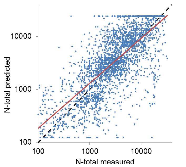
5 Relevés with abiotic measurements 4596 relevés in Netherlands, Austria and Ireland ph and N (N-total, C/N ratio and/or NO 3 ) 519 species that were found 25 relevés

6 Relevés with measurements of abiotic conditions
7 Response functions 2 dimensional response functions: ph N (N-total, CN, NO 3 ) logit(y) = α + β 1 ph + β 2 N + γ 1 ph 2 + γ 2 N 2 + δph N probability = 1/(1+exp(-logit(y))
8 Fitting of response functions
9 Example: Atriplex prostrata
10 Example: Calluna vulgaris
11 Results Number of plant species with response functions ph + N-total: 406 ph + CN ratio: 330 ph + NO 3 : 146
12 2. Extension number of species Problem: only few relevés where abiotic conditions have been measured response functions for few species how to get abiotic conditions for other relevés? Datasets: Abiotic dataset: ± 4600 relevés with measurements of abiotic conditions Bioscore dataset: ± 430,000 relevés without abiotic conditions
13 Bioscore dataset
14 methodology to include more species in PROPS 2 step approach: Step 1. estimate abiotic conditions based on presence of plant species with known response functions Step 2. derive response functions based on estimated abiotic conditions
15 estimation of abiotic conditions Abiotic dataset (± 400 species, response for ph and N) Sp1 Sp2 Spn species that in Bioscore with response functions in Abiotic dataset Bioscore dataset (430,000 relevés, ± 4,000 species) Sp1 Sp2 Spx relevé Sp1 Sp6 SP20 Sp78 Sp145 Sp221 Sp456 estimate ph and N from species with response functions (at least 5 species from abiotic dataset)
16 estimation of abiotic conditions

17 Bioscore dataset with abiotic conditions
18 Validation
19 Fitting response functions 4 dimensional response functions: ph N temperature precipitation logit(y) = α + β 1 x 1 + β 2 x 2 + β 3 x 3 + β 4 x 4 + γ 1 x γ 2 x γ 3 x γ 4 x δ 12 x 1 x 2 + δ 13 x 1 x 3 + δ 14 x 1 x 4 + δ 23 x 2 x 3 + δ 24 x 2 x 4 + δ 34 x 3 x 4
20 Results Number of plant species with response functions abiotic database ph + N-total: 406 ph + CN ratio: 330 ph + NO 3 : 146 Bioscore database ph + N-total: 2306 ph + CN ratio: 2309 ph + NO 3 : 1781
21 3. Preselect species in PROPS calculations 2300 species with response functions a-priori selection of species is required EUNIS classification is used in M&M work species selection related to EUNIS

 Wieger screened the remaining 7000 (!) combinations")
22 Step 1:Overlaying overlay of EUNIS map (level 2; e.g. B1) with Map for the Natural Vegetation for Europe. this gives per level 2 EUNIS class all possible vegetation types combine overlay with list of Level 3 EUNIS classes (e.g. B1.1) Wieger screened the remaining 7000 (!) combinations
23 Step 2: species assignment For each unit of the EuroVegMap units we got a list of typical/relevant species These can be linked to the PROPS list

24 In VSD+Studio it is implemented as follows:

25

26 Species options
27 Summary PROPS response functions (ph, N, T, prec.) for 2300 species a-priori selection of species based on vegetation type relatively few species for Scandinavia, Iberic peninsula, south-east of Europe
28 Thanks (VSD+ PROPS training session on wednesday afternoon)
CCE Call for Data , Swiss activities Dynamic Modelling
 CCE Call for Data, Swiss activities Dynamic Modelling Daniel Kurz (EKG Geo-Science, CH), Beat Achermann (FOEN, CH), Beat Rihm (Meteotest, CH) Models from: Luc Bonten & Gerd Jan Reinds (Alterra, NL) Max
CCE Call for Data , Swiss activities Dynamic Modelling
 CCE Call for Data 2012-14, Swiss activities Dynamic Modelling Daniel Kurz (EKG Geo-Science, CH), Beat Achermann (FOEN, CH), Beat Rihm (Meteotest, CH) Models from: Luc Bonten & Gerd Jan Reinds (Alterra,
Concepts for defining habitat distribution and validating habitat cluster potential
 23th CCE Workshop Copenhagen, 08.-11.04.2013 Concepts for defining habitat distribution and validating habitat cluster potential T. Scheuschner, German NFC Structure: - Introduction - Work for the current
Habitats habitat concept, identification, methodology for habitat mapping, organization of mapping
 Habitats habitat concept, identification, methodology for habitat mapping, organization of mapping Rastislav Lasák & Ján Šeffer Training Implementation of Habitats Directive - Habitats and Plants 1 What
Biomes Section 1. Chapter 6: Biomes Section 1: What is a Biome? DAY ONE
 Chapter 6: Biomes Section 1: What is a Biome? DAY ONE What is a Biome? Biomes are large regions characterized by a specific type of climate and certain types of plant and animal communities. The climate
New Results of Critical Load Calculation including Biodiversity
 33 rd ICP M & M Task Force Meeting New Results of Critical Load Calculation including Biodiversity Hans-Dieter Nagel, Angela Schlutow & Yolandi Bouwer (OEKO-DATA) Markus Geupel & Thomas Scheuschner (UBA)
Biomes of the World Roxanne Coffey Ms. Coffey
 Biomes of the World Roxanne Coffey Ms. Coffey DECIDUOUS FOREST DESCRIPTION The Deciduous Forest is a biome that is found throughout many parts of the world. It can be found on the Eastern side of North
Identifying Biomes from Climatograms
 Identifying Biomes from Welcome to your climatogram lab. In this lab you will investigate the between the amount of rainfall and the variance of temperature and the effect on the distribution of biomes
Unit 1. Sustaining Earth s Ecosystem
 Unit 1 Sustaining Earth s Ecosystem 1. Identify distinctive plants, animals, and climatic characteristics of Canadian biomes (tundra, boreal forest, temperate deciduous forest, temperate rainforest, grasslands)
Feedback between nutrient availability, NPP and N release
 Feedback between nutrient availability, NPP and N release 1 Redfield ratios A typical plant = 45% C, 1.5% N, 0.2%P or C:N = 30 : 1 and C:P = 225 : 1 or C:N:P = 225 : 7.5 : 1 N:P = 7.5 : 1 Mobility of nutrients
Biomes Survivor Research Project
 Biomes Survivor Research Project Information Sheet A biome is a region that can be identified by characteristic flora and fauna (plants and animals). The distribution patterns are strongly correlated with
Jay Lawrimore NOAA National Climatic Data Center 9 October 2013
 Jay Lawrimore NOAA National Climatic Data Center 9 October 2013 Daily data GHCN-Daily as the GSN Archive Monthly data GHCN-Monthly and CLIMAT messages International Surface Temperature Initiative Global
Modeling CO 2 sinks and sources of European land vegetation using remote sensing data
 Modeling CO 2 sinks and sources of European land vegetation using remote sensing data K. Wißkirchen, K. Günther German Aerospace Center (DLR), German Remote Sensing Data Center (DFD), Climate and Atmospheric
Supplementary material: Methodological annex
 1 Supplementary material: Methodological annex Correcting the spatial representation bias: the grid sample approach Our land-use time series used non-ideal data sources, which differed in spatial and thematic
Phylogenetically overdispersed plant communities are less. invasible
 Phylogenetically overdispersed plant communities are less invasible Andreas Prinzing, Pille Urbas, Meelis Pärtel, Stephan Hennekens, Joop Schaminée, Igor Bartish University of Rennes 1 / Centre National
Remote Sensing for Climate Change Effect on Lake Tahoe. Shobha Sriharan Professor of Environmental Science Virginia State University
 Remote Sensing for Climate Change Effect on Lake Tahoe Shobha Sriharan Professor of Environmental Science Virginia State University Table of Contents Lake Tahoe s Climate Issues Discussion on the issues
Ecosystems. Component 3: Contemporary Themes in Geography 32% of the A Level
 Ecosystems Component 3: Contemporary Themes in Geography 32% of the A Level Component 3 Written exam: 2hrs 15mins Section A Tectonic Hazards One compulsory extended response question 38 marks Section B
Unit 1: Basics of Geography Test Review
 Name Date Period Unit 1: Basics of Geography Test Review Directions: Reading the following sections and complete the questions, charts, and diagrams. Types of Maps Maps that have a particular theme are
a) Name the features marked P,Q, and R b) Differentiate between a normal faulty and a reverse fault. 2. Use the diagram below to answer question (a)
 Name the features marked P,Q, and R b) Differentiate between a normal faulty and a reverse fault. 2. Use the diagram below to answer question (a)") GEOGRAPHY PAPER 312 / 1 K.C.S.E 2002 SECTION A Answer all the questions in this section 1. The diagram below represents features produced by faulting. Use it to answer questions that follow. a) Name the
GEOGRAPHY PAPER 312 / 1 K.C.S.E 2002 SECTION A Answer all the questions in this section 1. The diagram below represents features produced by faulting. Use it to answer questions that follow. a) Name the
Ecosystems Chapter 4. What is an Ecosystem? Section 4-1
 Ecosystems Chapter 4 What is an Ecosystem? Section 4-1 Ecosystems Key Idea: An ecosystem includes a community of organisms and their physical environment. A community is a group of various species that
An Update on Land Use & Land Cover Mapping in Ireland
 An Update on Land Use & Land Cover Mapping in Ireland Progress Towards a National Programme Kevin Lydon k.lydon@epa.ie Office of Environmental Assessment, Environmental Protection Agency, Johnstown Castle,
Monday, Oct Field trip A1 & A2 signups: make sure you are where you think you should be
 Monday, Oct. 4 1. Field trip A1 & A2 signups: make sure you are where you think you should be 2. 5 credit people, field trip introduction in lab today 1. If you are unable to attend THIS SATURDAY, let
Prediction of soil properties with NIR data and site descriptors using preprocessing and neural networks
 Prediction of soil properties with NIR data and site descriptors using preprocessing and neural networks Matt Aitkenhead Malcolm Coull Jean Robertson 1 Introduction to NSIS A component of the Scottish
Biodiversity indicators for UK habitats: a process for determining species-weightings. Ed Rowe
 Biodiversity indicators for UK habitats: a process for determining species-weightings Ed Rowe Outline Progress with UK model chain What can our models predict? Why weight species? Alternative species weightings
Acid Soil. Soil Acidity and ph
 Acid Soil Soil Acidity and ph ph ph = - log (H + ) H 2 O H + + OH - (H + ) x (OH - )= K w = 10-14 measures H + activity with an electrode (in the lab), solutions (in the field) reflects the acid intensity,
The Norwegian monitoring program for sub-alpine birch-forests
 The Norwegian monitoring program for sub-alpine birch-forests Effects of air pollution and climate change on ground vegetation Vegar Bakkestuen & Per Arild Aarrestad Norwegian sub-alpine birch-forests
SoilGen2 model: data requirements and model output
 SoilGen2 model: data requirements and model output 1. Essential plot data... 1 2. Essential soil data... 2 3. Precipitation data (for a typical year)... 2 4. Evapotranspiration and Air temperature data
LAND USE MAPPING AND MONITORING IN THE NETHERLANDS (LGN5)
") LAND USE MAPPING AND MONITORING IN THE NETHERLANDS (LGN5) Hazeu, Gerard W. Wageningen University and Research Centre - Alterra, Centre for Geo-Information, The Netherlands; gerard.hazeu@wur.nl ABSTRACT
LAND USE MAPPING AND MONITORING IN THE NETHERLANDS (LGN5) Hazeu, Gerard W. Wageningen University and Research Centre - Alterra, Centre for Geo-Information, The Netherlands; gerard.hazeu@wur.nl ABSTRACT
System of Environmental-Economic Accounting. Advancing the SEEA Experimental Ecosystem Accounting. Extent Account (Levels 1 and 2)
") Advancing the SEEA Experimental Ecosystem Accounting Extent Account (Levels 1 and 2) Overview: The Extent Account 1. Learning objectives 2. Review of Level 0 (5m) What is it? Why do we need it? What does
Advancing the SEEA Experimental Ecosystem Accounting Extent Account (Levels 1 and 2) Overview: The Extent Account 1. Learning objectives 2. Review of Level 0 (5m) What is it? Why do we need it? What does
Chorological classification approach for species and ecosystem conservation practice
 IOP Conference Series: Earth and Environmental Science PAPER OPEN ACCESS Chorological classification approach for species and ecosystem conservation practice To cite this article: T V Rogova et al 2018
Abiotic Factors. Biotic Factors
 Name: Date: Block: Ecology Packet #1 Please read Ch. 3.1 (page 64-68) of your text. Answer questions below and practice organizing the information presented using the following graphic organizers. For
Use of satellite information in research and operational activities at NIMH of Bulgaria
 Use of satellite information in research and operational activities at NIMH of Bulgaria Rilka Valcheva NIMH, Bulgaria WMO/EUMETSAT Satellite Products Training Course 24-28 April 2017, Budapest, Hungary
AGOG 485/585 /APLN 533 Spring Lecture 5: MODIS land cover product (MCD12Q1). Additional sources of MODIS data
. Additional sources of MODIS data") AGOG 485/585 /APLN 533 Spring 2019 Lecture 5: MODIS land cover product (MCD12Q1). Additional sources of MODIS data Outline Current status of land cover products Overview of the MCD12Q1 algorithm Mapping
AGOG 485/585 /APLN 533 Spring 2019 Lecture 5: MODIS land cover product (MCD12Q1). Additional sources of MODIS data Outline Current status of land cover products Overview of the MCD12Q1 algorithm Mapping
Key Findings and Policy Briefs No. 2 SPATIAL ANALYSIS OF RURAL DEVELOPMENT MEASURES
 SPATIAL ANALYSIS OF RURAL DEVELOPMENT MEASURES Key Findings and Policy Briefs No. 2 RDP expenditures and their objectives from a spatial perspective: Does funding correspond to needs? RDP expenditures
Biomes and Ecosystems
 Name Biomes and Ecosystems Date How do Earth s biomes and ecosystems differ? Before You Read Before you read the chapter, think about what you know about biomes and ecosystems Record your thoughts in the
Name Class Date. For each pair of terms, explain how the meanings of the terms differ.
 Skills Worksheet Chapter Review USING KEY TERMS For each pair of terms, explain how the meanings of the terms differ. 1. biome and tropical zone 2. weather and climate 3. temperate zone and polar zone
Canada only has 7 of these biomes. Which biome do you think does not exist in Canada and why?
 Climate Zones and Biomes There are 8 defined biomes Permanent ice Tundra Boreal Forest Temperate deciduous forest Temperate rainforest Grassland Desert Tropical rainforest What is a biome? a major biotic
SCIENCE CURRICULUM MAPPING
 SCIENCE MAPPING UNIT: E Dates: From Sept. 5,2008 Grade: Third To Oct. 2, 2008 From: 9/5/08 To: 9/22/08 Properties of Matter What are Physical Properties of Matter? What are solids, liquids, and gases?
Building a European-wide hydrological model
 Building a European-wide hydrological model 2010 International SWAT Conference, Seoul - South Korea Christine Kuendig Eawag: Swiss Federal Institute of Aquatic Science and Technology Contribution to GENESIS
CHAPTER-11 CLIMATE AND RAINFALL
 CHAPTER-11 CLIMATE AND RAINFALL 2.1 Climate Climate in a narrow sense is usually defined as the "average weather", or more rigorously, as the statistical description in terms of the mean and variability
RiskCity Training package on the Application of GIS for multi- hazard risk assessment in an urban environment.
 RiskCity Training package on the Application of GIS for multi- hazard risk assessment in an urban environment. Cees van Westen (Westen@itc.nl) & Nanette C. Kingma (Kingma@itc.nl) ITC: Training & Research
Agrometeorological activities in RHMSS
 Republic of Serbia Republic Hydrometeorological Service of Serbia Agrometeorological activities in RHMSS Department for applied climatology and agrometeorology www.hidmet.gov.rs Meteorological Observing
Lecture 6: Soil Profiles: Diagnostic Horizons
 Lecture 6: Soil Profiles: Diagnostic Horizons Complexity in Soil Profiles Soil Horizons Soils display distinct layering O Horizon: Partially decomposed organic matter (OM) A Horizon: Near surface, mineral
Our climate system is based on the location of hot and cold air mass regions and the atmospheric circulation created by trade winds and westerlies.
 CLIMATE REGIONS Have you ever wondered why one area of the world is a desert, another a grassland, and another a rainforest? Or have you wondered why are there different types of forests and deserts with
312/1 GEOGRAPHY PAPER 1 EMBU NORTH EVALUATION EXAM JULY /AUGUST 2018 TIME: 2HRS 45 MIN INSTRUCTIONS
 312/1 GEOGRAPHY PAPER 1 EMBU NORTH EVALUATION EXAM JULY /AUGUST 2018 TIME: 2HRS 45 MIN INSTRUCTIONS 1. Answer all questions in section A 2. In section B answer question 6 and any other two questions. 3.
10/27/2015. Content. Well-homogenized national datasets. Difference (national global) BEST (1800) Difference BEST (1911) Difference GHCN & GISS (1911)
 BEST (1800) Difference BEST (1911) Difference GHCN & GISS (1911)") Content Is the global mean temperature trend too low? Victor Venema, Phil Jones, Ralf Lindau, Tim Osborn and numerous collaborators @VariabilityBlog variable-variability.blogspot.com 1. Comparison trend
Content Is the global mean temperature trend too low? Victor Venema, Phil Jones, Ralf Lindau, Tim Osborn and numerous collaborators @VariabilityBlog variable-variability.blogspot.com 1. Comparison trend
Fundamentals of THE PHYSICAL ENVIRONMENT. David Briggs, Peter Smithson, Kenneth Addison and Ken Atkinson
 Fundamentals of THE PHYSICAL ENVIRONMENT Second Edition David Briggs, Peter Smithson, Kenneth Addison and Ken Atkinson LONDON AND NEW YORK Contents L,ISI Of colour piates List of black and white plates
Climate Change and Arizona s Rangelands: Management Challenges and Opportunities
 Climate Change and Arizona s Rangelands: Management Challenges and Opportunities Mike Crimmins Climate Science Extension Specialist Dept. of Soil, Water, & Env. Science & Arizona Cooperative Extension
Climate Change and Biomes
 Climate Change and Biomes Key Concepts: Greenhouse Gas WHAT YOU WILL LEARN Biome Climate zone Greenhouse gases 1. You will learn the difference between weather and climate. 2. You will analyze how climate
Temperature and Precipitation. Next stage will depend on climate and parent materials
 Next stage will depend on climate and parent materials Rainfall and temperature will determine nature of vegetation Resistance of parent material to weathering will determine rate and type of clay formation,
Igneous rocks + acid volatiles = sedimentary rocks + salty oceans
 The Lithosphere Weathering physical processes chemical processes biological processes weathering rates Soil development soil formation processes types of soils and vegetation soil properties physical chemical
SIF_7.1_v2. Indicator. Measurement. What should the measurement tell us?
 Indicator 7 Area of natural and semi-natural habitat Measurement 7.1 Area of natural and semi-natural habitat What should the measurement tell us? Natural habitats are considered the land and water areas
Project: What are the ecological consequences of trophic downgrading in mixed/short grass prairies in North America?
 Project: What are the ecological consequences of trophic downgrading in mixed/short grass prairies in North America? Premise: North American ecosystems have fundamentally changed over the late Pleistocene
Nutrient Cycling in Land Vegetation and Soils
 Nutrient Cycling in Land Vegetation and Soils OCN 401 - Biogeochemical Systems 15 September 2016 Reading: Schlesinger & Bernhardt, Chapter 6 2016 Frank Sansone Outline 1. The annual Intrasystem Nutrient
RETRIEVAL OF SOIL MOISTURE OVER SOUTH AMERICA DERIVED FROM MICROWAVE OBSERVATIONS
 2nd Workshop on Remote Sensing and Modeling of Surface Properties 9-11 June 2009, Toulouse, France Météo France Centre International de Conférences RETRIEVAL OF SOIL MOISTURE OVER SOUTH AMERICA DERIVED
All of Virginia's 4 main rivers flow into the... Chesapeake Bay. Along which river would Jamestown be found? James River. Appalachian Mountains
 All of Virginia's 4 main rivers flow into the... Along which river would Jamestown be found? The Blue Ridge Mountains and Valley and Ridge are part of what large mountain system? Define climate. Define
Lab 8 Dynamic Soil Systems I: Soil ph and Liming
 Lab 8 Dynamic Soil Systems I: Soil ph and Liming Objectives: To measure soil ph and observe conditions which change ph To distinguish between active acidity (soil solution ph) and exchangeable acidity
Classification of ecosystem types: Experiences and perspectives from Statistics Canada
 Classification of ecosystem types: Experiences and perspectives from Statistics Canada Jennie Wang, François Soulard, Mark Henry, Marcelle Grenier Environmental Accounts and Statistics Program Statistics
Using MERIS and MODIS for Land Cover Mapping in the Netherlands
 Using MERIS and for Land Cover Mapping in the Netherlands Raul Zurita Milla, Michael Schaepman and Jan Clevers Wageningen University, Centre for Geo-Information, NL Introduction Actual and reliable information
Predicting ectotherm disease vector spread. - Benefits from multi-disciplinary approaches and directions forward
 Predicting ectotherm disease vector spread - Benefits from multi-disciplinary approaches and directions forward Naturwissenschaften Stephanie Margarete THOMAS, Carl BEIERKUHNLEIN, Department of Biogeography,
ESTIMATION OF BIOGENIC NMVOCs EMISSIONS OVER THE BALKAN REGION
 ESTIMATION OF BIOGENIC NMVOCs EMISSIONS OVER THE BALKAN REGION Poupkou A. 1, Symeonidis P. 1, Melas D. 1, Balis D. 1 and Zerefos C. 2,3 1 Laboratory of Atmospheric Physics, Department of Physics, AUTH
Lect. 2: Chemical Water Quality
 The Islamic University of Gaza Faculty of Engineering Civil Engineering Department M.Sc. Water Resources Water Quality Management (ENGC 6304) Lect. 2: Chemical Water Quality ١ Chemical water quality parameters
Soil Biology and Monitoring Environmental Change. Matthew Shepherd Senior Specialist, Soil Biodiversity, Natural England
 Soil Biology and Monitoring Environmental Change Matthew Shepherd Senior Specialist, Soil Biodiversity, Natural England Soil Biology and Monitoring Environmental Change Generations have trod, have trod,
CHAPTER 52: Ecology. Name: Question Set Define each of the following terms: a. ecology. b. biotic. c. abiotic. d. population. e.
 CHAPTER 52: Ecology 1. Define each of the following terms: a. ecology b. biotic c. abiotic d. population e. community f. ecosystem g. biosphere 2. What is dispersal? 3. What are the important factors that
Lesson Plan for Santa Rita Experimental Range Vegetation Monitoring Martha Gebhardt, Outreach Coordinator
 Lesson Plan for Santa Rita Experimental Range Vegetation Monitoring Martha Gebhardt, Outreach Coordinator Objectives: Part 1: Students will learn about common plant species on SRER through vegetation monitoring
Name period date assigned date due date returned. Texas Ecoregions
 Name period date assigned date due date returned Directions: Go to the following website: https://www-k6.thinkcentral.com/epc/start.do Use the log in that is taped to the top of your laptop. If you are
Name Date Class. well as the inland, found near the Tropics. 4. In the, or the regions near the Equator, you may find a lush
 WATER, CLIMATE, AND VEGETATION Vocabulary Activity DIRECTIONS: Fill in the Blanks Select a term from below to complete each of the following sentences. CHAPTER 1. The constant movement of water, a process
Ecology 312 SI STEVEN F. Last Session: Aquatic Biomes, Review This Session: Plate Tectonics, Lecture Quiz 2
 Ecology 312 SI STEVEN F. Last Session: Aquatic Biomes, Review This Session: Plate Tectonics, Lecture Quiz 2 Questions? Warm up: KWL KNOW: On a piece of paper, write down things that you know well enough
This is trial version
 Journal of Rangeland Science, 2012, Vol. 2, No. 2 J. Barkhordari and T. Vardanian/ 459 Contents available at ISC and SID Journal homepage: www.rangeland.ir Full Paper Article: Using Post-Classification
Describe how ecosystems recover from a disturbance. Compare succession after a natural disturbance with succession after a human-caused disturbance.
 1 2 Objectives Describe how ecosystems recover from a disturbance. Compare succession after a natural disturbance with succession after a human-caused disturbance. 3 Succesion Cartoon Guide to the Environment
3.1 Distribution of Organisms in the Biosphere Date:
 3.1 Distribution of Organisms in the Biosphere Date: Warm up: Study Notes/Questions The distribution of living things is limited by in different areas of Earth. The distribution of life in the biosphere
CropCast Europe Weekly Report
 CropCast Europe Weekly Report Kenny Miller Monday, June 05, 2017 Europe Hot Spots Abundant showers should ease dryness across northern and central UK as well as across western Norway and Sweden. Improvements
LUCAS: current product and its evolutions
 LUCAS: current product and its evolutions Workshop Land Use and Land Cover products: challenges and opportunities Brussels 15 Nov 2017 Eurostat E4: estat-dl-lucas@ec.europa.eu Contents 1) The context 2)
Classification. Classification is the ordering of organisms into groups on the basis of their relationships. The groups are known as Taxon s.
 Classification What is classification? Classification is the ordering of organisms into groups on the basis of their relationships. The groups are known as Taxon s. Why do we classify? Biologists classify
1 What Is Climate? TAKE A LOOK 2. Explain Why do areas near the equator tend to have high temperatures?
 CHAPTER 17 1 What Is Climate? SECTION Climate BEFORE YOU READ After you read this section, you should be able to answer these questions: What is climate? What factors affect climate? How do climates differ
GCSE 4241/02 GEOGRAPHY (Specification B) HIGHER TIER UNIT 1
 HIGHER TIER UNIT 1") Surname Centre Number Candidate Number Other Names 0 GCSE 4241/02 GEOGRAPHY (Specification B) HIGHER TIER UNIT 1 S15-4241-02 P.M. TUESDAY, 19 May 2015 1 hour For s use Question Maximum Mark Mark Awarded
Surname Centre Number Candidate Number Other Names 0 GCSE 4241/02 GEOGRAPHY (Specification B) HIGHER TIER UNIT 1 S15-4241-02 P.M. TUESDAY, 19 May 2015 1 hour For s use Question Maximum Mark Mark Awarded
Nutrient Cycling in Land Plants
 Nutrient Cycling in Land Plants OCN 401 - Biogeochemical Systems 7 September 2017 Reading: Chapter 6 2017 Frank Sansone Outline 1. Plant nutrient requirements and sources 2. Nutrient uptake by plants Nutrient
The future of the Lowland Belizean Savannas?.
 The future of the Lowland Belizean Savannas?. Using cluster analysis to explore multivariate spatial patterns in savanna soils PETER FURLEY & SARAH BEADLE UK Belize association 15 th November 2014 Outline
Remote Sensing Geographic Information Systems Global Positioning Systems
 Remote Sensing Geographic Information Systems Global Positioning Systems Assessing Seasonal Vegetation Response to Drought Lei Ji Department of Geography University of Nebraska-Lincoln AVHRR-NDVI: July
Lesson 2: Terrestrial Ecosystems
 Lesson 2: Terrestrial Ecosystems A terrestrial ecosystem is a land ecosystem. Terrestrial ecosystems include tundra, forests, grasslands, deserts, and rainforests. 1 The arctic tundra is earth s coldest
forest tropical jungle swamp marsh prairie savanna pampas Different Ecosystems (rainforest)
") Different Ecosystems forest A region of land that is covered with many trees and shrubs. tropical jungle (rainforest) swamp A region with dense trees and a variety of plant life. It has a tropical climate.
Different Ecosystems forest A region of land that is covered with many trees and shrubs. tropical jungle (rainforest) swamp A region with dense trees and a variety of plant life. It has a tropical climate.
EAP-ILTER: Regional Effort for Ecosystem Research and Management under Climate Change
 EAP-ILTER: Regional Effort for Ecosystem Research and Management under Climate Change ZHAO Shidong Institute of Geographic Sciences and Natural Resources Research, CAS International Long Term Ecological
Critical success factors for revegetation of heavily polluted sites.
 Critical success factors for revegetation of heavily polluted sites. A cost-benefit analysis tool. Jan Japenga, Paul Römkens, Luc Bonten Soil Science Centre ALTERRA Green World Research, Wageningen University
USING HYPERSPECTRAL IMAGERY
 USING HYPERSPECTRAL IMAGERY AND LIDAR DATA TO DETECT PLANT INVASIONS 2016 ESRI CANADA SCHOLARSHIP APPLICATION CURTIS CHANCE M.SC. CANDIDATE FACULTY OF FORESTRY UNIVERSITY OF BRITISH COLUMBIA CURTIS.CHANCE@ALUMNI.UBC.CA
Lecture #19 MINEQL: Intro & Tutorial Benjamin; Chapter 6
 Updated: 6 October 2013 Print version Lecture #19 MINEQL: Intro & Tutorial Benjamin; Chapter 6 David Reckhow CEE 680 #19 1 MINEQL today MINEQL is available from Environmental Research Software: http://www.mineql.com/
Introduction to GIS I
 Introduction to GIS Introduction How to answer geographical questions such as follows: What is the population of a particular city? What are the characteristics of the soils in a particular land parcel?
Spatial Optimization of CoCoRAHS Network in Tennessee. Joanne Logan Department of Biosystems Engineering and Soil Science University of Tennessee
 Spatial Optimization of CoCoRAHS Network in Tennessee Joanne Logan Department of Biosystems Engineering and Soil Science University of Tennessee Abstract CoCoRaHS (Community Collaborative Rain, Hail and
Hydrologic and Hydraulic Analyses Using ArcGIS
 Hydrologic and Hydraulic Analyses Using ArcGIS Two day training class Overview ArcGIS and Arc Hydro provide strong foundation for support of hydrologic and hydraulic (H&H) analyses. This two-day course
Utility of National Spatial Data for Conservation Design Projects
 Utility of National Spatial Data for Conservation Design Projects Steve Williams Biodiversity and Spatial Information Center North Carolina State University PIF CDW St. Louis, MO April 11, 2006 Types of
Name Hour. Chapter 4 Review
 Name Hour Chapter 4 Review 1. The average, year-after-year conditions of temperature and precipitation within a particular region are its weather. climate. greenhouse effect. d. biotic factors. 2. The
Land Use and Land cover statistics (LUCAS)
") EUROPEAN COMMISSION EUROSTAT Directorate E: Sectoral and regional statistics Doc. ENV/DIMESA/7.1/2012 Original in EN Agenda point 7.1 Land Use and Land cover statistics (LUCAS) DIMESA Directors' Meeting
EUROPEAN COMMISSION EUROSTAT Directorate E: Sectoral and regional statistics Doc. ENV/DIMESA/7.1/2012 Original in EN Agenda point 7.1 Land Use and Land cover statistics (LUCAS) DIMESA Directors' Meeting
The Influence of Historical and Projected Land Use and Land Cover Changes on Land Surface Hydrology and Regional Weather and Climate Variability
 The Influence of Historical and Projected Land Use and Land Cover Changes on Land Surface Hydrology and Regional Weather and Climate Variability Research Hypothesis: Land use and land cover changes are
Mycorrhizal Fungi. Symbiotic relationship with plants -- form sheath around fine roots and extend hyphae into soil and sometimes into root cells
 Mycorrhizal Fungi Symbiotic relationship with plants -- form sheath around fine roots and extend hyphae into soil and sometimes into root cells Mycorrhizae transfer nutrients to roots (important in infertile
Soils and Soil Minerals. Remember, most things can be too little or too much.
 Soils and Soil Minerals Remember, most things can be too little or too much. 1 2 3 Source of essential elements CO 2, O 2 from atmosphere H 2 0, O 2, minerals from soil NH 4, SO 4 can volatilize and be
Data Analysis and Modeling with Stable Isotope Ratios. Chun-Ta Lai San Diego State University June 2008
 Data Analysis and Modeling with Stable Isotope Ratios Chun-Ta Lai San Diego State University June 2008 Leaf water is 18 O-enriched via transpiration δ 18 O vapor : -12 H 2 16 O H 2 18 O δ 18 O leaf : +8
2007: The Netherlands in a drought again (2 May 2007)
") 2007: The Netherlands in a drought again (2 May 2007) Henny A.J. van Lanen, Wageningen University, the Netherlands (henny.vanlanen@wur.nl) Like in June and July 2006, the Netherlands is again facing a
2007: The Netherlands in a drought again (2 May 2007) Henny A.J. van Lanen, Wageningen University, the Netherlands (henny.vanlanen@wur.nl) Like in June and July 2006, the Netherlands is again facing a
Global Carbon Cycle - I
 Global Carbon Cycle - I Reservoirs and Fluxes OCN 401 - Biogeochemical Systems 13 November 2012 Reading: Schlesinger, Chapter 11 Outline 1. Overview of global C cycle 2. Global C reservoirs 3. The contemporary
Markville. CGC 1DL/PL Geography. Geography of Canada. Natural Environment Unit Test
 Markville CGC 1DL/PL Geography Geography of Canada Natural Environment Unit Test Name: Thinking /10 Knowledge /10 Application /10 Communication /10 Part A: Blanks (1 mark each) Thinking Choose the correct
Introduction. Ecology is the scientific study of the interactions between organisms and their environment.
 Introduction Ecology is the scientific study of the interactions between organisms and their environment. 1. The interactions between organisms and their environments determine the distribution and abundance
Weather is the day-to-day condition of Earth s atmosphere.
 4.1 Climate Weather and Climate Weather is the day-to-day condition of Earth s atmosphere. Climate refers to average conditions over long periods and is defined by year-after-year patterns of temperature