LUCAS: current product and its evolutions
|
|
|
- Daisy Norton
- 6 years ago
- Views:
Transcription

1 LUCAS: current product and its evolutions Workshop Land Use and Land Cover products: challenges and opportunities Brussels 15 Nov 2017 Eurostat E4:
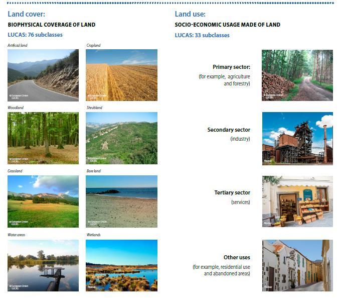
2 Contents 1) The context 2) Methodological overview 3) Products What is available / Where to find / How to use 4) Use Cases 5) Conclusions
3 a) a) What What is LUCAS is LUCAS LUCAS Field survey characteristics LUCAS stands for Land Use and Cover Area-frame Survey Organised by Eurostat every 3 years since 2001 Harmonized in-situ European data collection Georeferenced point Detailed classification; separate LC LU Multiple parameters Ad hoc modules Precision indicators Reduced % of missing data No burden on respondents
4 a) Historical background - LUCAS is a User oriented product From crops early estimates to more environmental oriented ( ) To Solid multipurpose platform including ad hoc modules [soil / transect / grassland] and other adaptations [FAO / INSPIRE / Copernicus] (from 2009 onward) Regular User needs consultations
5 LUCAS User Needs - Survey 2018 Main DGs: AGRI, ENV, CLIMA, GROW Started in 2014 Questionnaire, bilateral meetings, workshops Grassland, Soil, Copernicus Eurostat
6 LUCAS User Needs - Grassland Biodiversity 7 EAP (Action 5: Env. Knowledge Base), Biodiversity Strategy 2020, NATURA 2000 Ecosystems & Ecosystem Services Greening the CAP Quality of the grassland Climate Change COPERNICUS Environmental Information Statistical assessment: Carbon sequestration High Resolution Layers EUNIS classification Environmental value, abandonment/intensification processes (time series) Eurostat
7 New soil properties New soil parameters Bulk density Soil biodiversity Thickness of organic horizon in peats Soil erosion Why is important? Movement and storage of water and solutes Soil aeration Calculation of stock of organic carbon Nutrient cycling and fertility Regulation of carbon flux and climate control Regulation of the water cycle Decontamination and bioremediation Pest control Source of pharmaceutical resources Carbon sequestration and climate control Loss of fertile soil Reduction of soil productivity Water pollution Sample required Soil rings Frozen soil samples Field measurement Field observation Eurostat
8 Eurostat
9 b) methodology Eurostat
: MASTER 2018: 1.090.")
: 240.")
10 How is LUCAS conducted LUCAS sampling design BASE 11 (1 km European INSPIRE Grid): points EU28 BASE 22 (2 km Grid): MASTER 2018: points First phase photointerpretation Stratification into 10 strata 10 Field SAMPLE 2018 (EU 28): points + Office PI Sample : points = total sample
11 Stratification update On points of of LUCAS Grid (2 by 2) 10 strata (arable land, permanent crops, grass, wooded areas, shrubs, bare surface, artificial constructions and sealed areas, transitional and coastal water and "impossible to photo-interpret") impact on Sample design impact on Estimates [calibration] Eurostat
12 Sample design 2018 It covers all territory of EU including both field part and photo interpreted sample. It takes into account accessibility of the single points, possibly revising the accessibility criteria used so-far. It takes into account the propensity to change of land cover. It fulfils the requirements and instructions for the new elements of the LUCAS 2018 survey (soil package, grassland module and Copernicus adaptation). It ensures as much as possible comparability with the previous LUCAS surveys. It allows solid estimation of main variables at the lowest regional level possible

13 Revised sample structure
14 Longitudinal structure of 2018 sample Total number of points : of which 23% surveyed already in 2009/2012/ % visited once or twice 52% new entries
15 New Elements in the estimation (2015) Estimation process involves: Alignment of classification 2009/2012 to 2015 Mapping of LUCAS classification/parameters to FAO classification [fine-tuned algorithm] Taking into account LC1/LC2 (Weight split LC1_percent LC2_percent) LU1/LU2 (50 / 50%) Inclusion of field and PI points to last 3 surveys Treatment of transitional water as separate strata NUTS 2013 Two set of aggregated tables for Land Cover According to LUCAS classification According to FAO forest classes Eurostat
16 Constraint to the Master Totals - IPF Elevation in 6 classes NUTS2 by STRATA NUTS1 by elevation (4 classes) NUTS0 by strata by elevation (6 classes) Country Eurostat
17 Assessment of 2015 results Total Coverage of LUCAS Area [Field combined with PI] Better use of LUCAS parameters (LC1/2 & FAO) Improved coherence w/ other statistics [MS (eg. Secondary sector NL) and CLC] Overall coherence with FAOSTAT


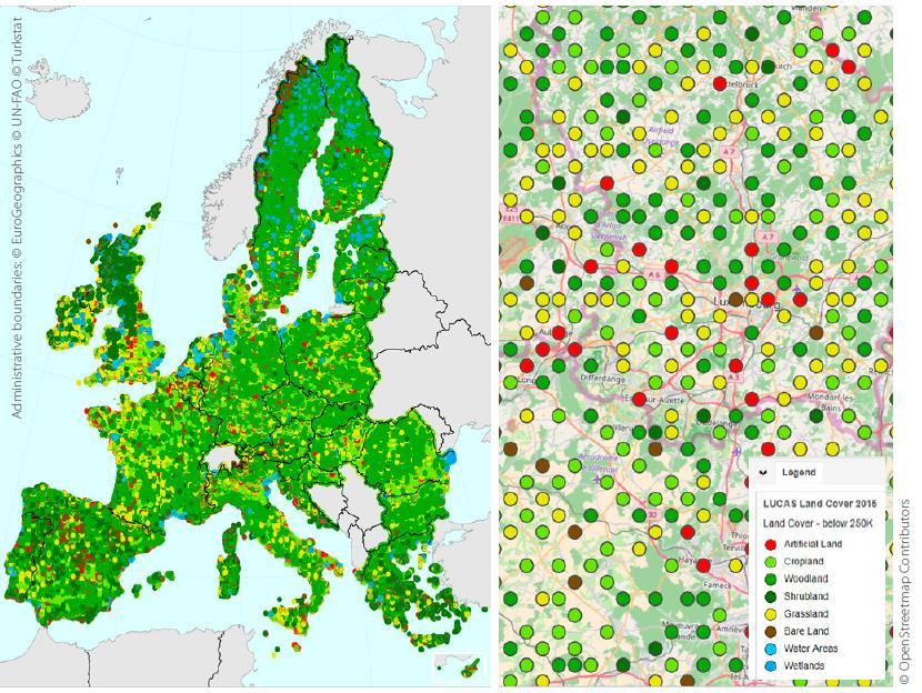
18 LUCAS data collection process Photointerpretation : Classification in 10 strata points Dissemination Parameters Land cover Land use Transect, etc. FOREST AREA GRASSLAND CEREALS SHRUBLAND, ARTIFICIAL NON BUILT-UP AREAS BARE LAND OTHER PERMANENT CROPS NON PERMANENT INDUSTRIAL CROPS OTHER WOODED AREA BUILT-UP AREAS WATER PERMANENT CROPS ROOT CROPS FODDER CROPS DRY PULSES, VEGETABLES AND FLOWERS Total Sample of 370,000 pts Ground survey
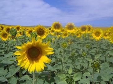
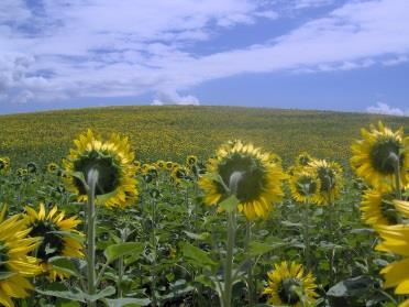
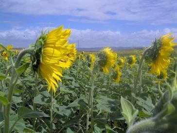
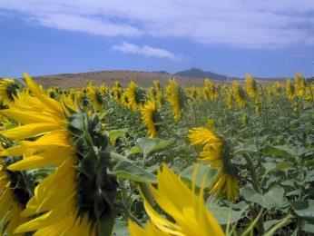

19 Data collection process: Ground survey Land Cover "sun-flower Land Use agriculture North West East South 19

20 LUCAS production process Use of auxiliary information and aerial images Eurostat
21 How are RS and auxiliary information integrated in LUCAS Role of PI 1) PI of master grid 2) PI in field [wall fence, military area] 3) PI of excluded areas Role of auxiliary info 1) Preparation of master (elevation, road..) 2) Eligibility criteria [ CLC] 3) Ground Document preparation 4) Visual Quality Control

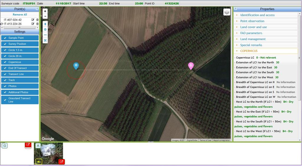
22 Example of Ground Document
23 Informative content Classification Alignments with INSPIRE PLLC for vegetation Core LUCAS Current land cover and land use + Environmental information (e.g. irrigation, grazing, burned areas) Add on Current products [transect/ soil] LUCAS 2018 Soil "extended" Grassland Copernicus [specific instructions / degree of urbanization (parameter)/ % of imperviousness
24 INFORMATIVE CONTENT


25 Environmental parameters - % of LC <10 % % >75 % For coverages with trees: assess the crown coverage Land cover refers LC1: B71; LC1% <10% LC2: E20; LC2% >75% LC 1: C10; LC1%: >75% When summed up, % can be below or above 100 % 25

; ph")

26 ad hoc modules 1) Transect 2015 Land cover transect classification List of transect linear elements 2) Top-Soil parameters soil types; soil textures (sand, silt, clay); ph levels; organic carbon; phosphorous, nitrogen and potassium; soil erosion; susceptibility to compaction 26
27 Adaptations to Copernicus (test module 2018) a) Sampling: 50 points per class per validation area b) In-situ information: Extent of land cover in the 4 cardinal directions Record first new land cover Up to 50 m c) - Classification fine tuning: e.g. Exclude combination G12/U111 Info on airport/port for U317 Logistics and storage Separate U361: Amenities, leisure/museum, culture
28
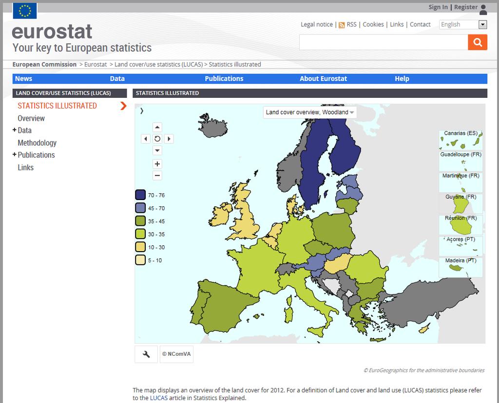
29 Output What do we publish Where to find the information Eurostat

30 LUCAS products
31 LUCAS surveys' output 3 types of harmonised land cover/use information for EU: Micro data (primary data): land cover, land use and environmental parameters associated to the single surveyed points, Point and landscape photos in the four cardinal directions, Statistical tables with aggregated results by land cover, land use at geographical level (estimates based on point data conveniently weighted). 31
![POINT INFORMATION GRID [2 x 2 Km] http://ec.europa.](/docs-images/77/74705218/images/32-2.jpg "eu/eurostat/web/lucas/data/luca s-grid 1090863 points Primary data: by year Country file Survey Documentation")
32 POINT INFORMATION GRID [2 x 2 Km] s-grid points Primary data: by year Country file Survey Documentation (field form, Instruction, classification, nuts_area, quality check..)

33 LUCAS Primary data: Country-specific files available at 33


34 LUCAS 2015 LC - unweighted results Field points PI points
35 Indicators 35

36 Examples of photographs Central photograph: the surveyed LUCAS point; remaining images taken from the surveyed point to the north, south, east and west.


37 LUCAS Viewer Interactive photo viewer within Eurostat s statistical atlas 37

38 LUCAS Photo archive: 2006,2009,2012,2015 How to access Photo archive from LUCAS. Photographs can be requested by using the online form at/web/lucas/data/primarydata/order-form
39

40 Database Data base / LC / LU / FAO: KM 2 % of total area Cv M 2 per capita / for artificial areas
41 How to use the data NUTS classification Estimates on line currently at 2013 Nuts POINT coordinates LUCAS point is a theoretical point located on the grid. Coordinates of the theoretical point are available in the LUCAS Grid both non projected (WGS84 latitude and longitude) and projected Lambert Albers Equal Area (ETRS89 + LAEA). On the survey microdata you can find the coordinates from where the point was observed by the surveyor (also in WGS84 latitude and longitude).
42 What is LUCAS used for? Policy areas: Data from LUCAS can be used to help analyse and contribute to the development of various EU policy areas: Common Agricultural Policy Integrating environmental concerns in the Common Agricultural Policy; Soil thematic strategy Protecting the soil, as detailed in the soil thematic strategy; EU biodiversity strategy Promoting biodiversity and conservation, through the EU s biodiversity strategy; Europe 2020 Encouraging the efficient use of resources for sustainable growth, as in the resource-efficient Europe initiative; Copernicus Land monitoring, spatial planning and resource management, as carried out by the Copernicus earth observation programme; Climate change Tackling climate change, through monitoring conducted by the European Environment Agency, as well as actions under the European climate change programme.


43 USE CASES LUCAS Survey 2015 NUTS 3 average number of linear elements per transect with agriculture as main land cover Soil erodibility in Europe (K factor)
44 CONCLUSION User oriented product Interrelation with national/ pan-european products Towards which convergence LUCAS / Copernicus?

45 Thank you for your attention! The new LUCAS compact guide is coming soon:
Directorate E: Sectoral and regional statistics Unit E-4: Regional statistics and geographical information LUCAS 2018.
 EUROPEAN COMMISSION EUROSTAT Directorate E: Sectoral and regional statistics Unit E-4: Regional statistics and geographical information Doc. WG/LCU 52 LUCAS 2018 Eurostat Unit E4 Working Group for Land
LUCAS Technical reference document U1 LUCAS Survey data user guide. (Land Use / Cover Area Frame Survey)
") Regional statistics and Geographic Information Author: E4.LUCAS (ESTAT) TechnicalDocuments 2015 LUCAS 2015 (Land Use / Cover Area Frame Survey) Technical reference document U1 LUCAS Survey data user guide
Regional statistics and Geographic Information Author: E4.LUCAS (ESTAT) TechnicalDocuments 2015 LUCAS 2015 (Land Use / Cover Area Frame Survey) Technical reference document U1 LUCAS Survey data user guide
Use of auxiliary information in the sampling strategy of a European area frame agro-environmental survey
 Use of auxiliary information in the sampling strategy of a European area frame agro-environmental survey Laura Martino 1, Alessandra Palmieri 1 & Javier Gallego 2 (1) European Commission: DG-ESTAT (2)
Land Use and Land cover statistics (LUCAS)
") EUROPEAN COMMISSION EUROSTAT Directorate E: Sectoral and regional statistics Doc. ENV/DIMESA/7.1/2012 Original in EN Agenda point 7.1 Land Use and Land cover statistics (LUCAS) DIMESA Directors' Meeting
EUROPEAN COMMISSION EUROSTAT Directorate E: Sectoral and regional statistics Doc. ENV/DIMESA/7.1/2012 Original in EN Agenda point 7.1 Land Use and Land cover statistics (LUCAS) DIMESA Directors' Meeting
Sampling scheme for LUCAS 2015 J. Gallego (JRC) A. Palmieri (DG ESTAT) H. Ramos (DG ESTAT)
 A. Palmieri (DG ESTAT) H. Ramos (DG ESTAT)") Sampling scheme for LUCAS 2015 J. Gallego (JRC) A. Palmieri (DG ESTAT) H. Ramos (DG ESTAT) Abstract The sampling design of LUCAS 2015 took into account experience from previous campaigns. While remaining
Sampling scheme for LUCAS 2015 J. Gallego (JRC) A. Palmieri (DG ESTAT) H. Ramos (DG ESTAT) Abstract The sampling design of LUCAS 2015 took into account experience from previous campaigns. While remaining
Compact guides GISCO. Geographic information system of the Commission
 Compact guides GISCO Geographic information system of the Commission What is GISCO? GISCO, the Geographic Information System of the COmmission, is a permanent service of Eurostat that fulfils the requirements
LUCAS 2009 (Land Use / Cover Area Frame Survey)
") EUROPEAN COMMISSION EUROSTAT Directorate E: Sectoral and regional statistics Unit E-1: Farms, agro-environment and rural development LUCAS 2009 (Land Use / Cover Area Frame Survey) M3 - Non sampling error
EUROPEAN COMMISSION EUROSTAT Directorate E: Sectoral and regional statistics Unit E-1: Farms, agro-environment and rural development LUCAS 2009 (Land Use / Cover Area Frame Survey) M3 - Non sampling error
EAGLE Data Model and Outcomes of HELM (Harmonised European Land Monitoring)
") EAGLE Data Model and Outcomes of HELM (Harmonised European Land Monitoring) Contribution towards better land information harmonisation and INSPIRE compliance EAGLE working group Stephan Arnold, Barbara
EAGLE Data Model and Outcomes of HELM (Harmonised European Land Monitoring) Contribution towards better land information harmonisation and INSPIRE compliance EAGLE working group Stephan Arnold, Barbara
Land Monitoring Core Service Implementation Group (LMCS IG) - Results and Outlook
 - Results and Outlook") Land Monitoring Core Service Implementation Group (LMCS IG) - Results and Outlook Pr. Dietmar Grünreich, President of BKG, Germany Chairman of the GMES LMCS IG Outline 1 Introduction 2 Preparatory Projects
Land Monitoring Core Service Implementation Group (LMCS IG) - Results and Outlook Pr. Dietmar Grünreich, President of BKG, Germany Chairman of the GMES LMCS IG Outline 1 Introduction 2 Preparatory Projects
The Role of EO Consultants and SMEs within GMES. Geoff Smith
 The Role of EO Consultants and SMEs within GMES Geoff Smith Enable clients to deliver useful, accurate and reliable environmental information from EO. Positioned to bridge the gaps between technology development,
Pilot studies on the provision of harmonized land use/land cover statistics: Synergies between LUCAS and the national systems
 1 Pilot studies on the provision of harmonized land use/land cover statistics: Synergies between LUCAS and the national systems Norway Erik Engelien Division for Natural resources and Environmental Statistics,
Possible links between a sample of VHR images and LUCAS
 EUROPEAN COMMISSION EUROSTAT Directorate E: Sectoral and regional statistics Unit E-1: Farms, agro-environment and rural development CPSA/LCU/08 Original: EN (available in EN) WORKING PARTY "LAND COVER/USE
Copernicus for Statistics
 Copernicus for Statistics Stephan Arnold Areal statistics, Federal Statistical Office Thomas Wiatr Remote sensing, Federal Agency for Cartography and Geodesy Content Requirements and Setting Eurostat s
Redesign sample for Land Use/Cover Area frame Survey (LUCAS) 2018
 2018") Redesign sample for Land Use/Cover Area frame Survey (LUCAS) 2018 MARCO BALLIN, GIULIO BARCAROLI, MAURO MASSELLI, MARCO SCARNÓ S TAT I S T I C A L W O R K I N G PA P E R S 2018 edition Redesign sample
Redesign sample for Land Use/Cover Area frame Survey (LUCAS) 2018 MARCO BALLIN, GIULIO BARCAROLI, MAURO MASSELLI, MARCO SCARNÓ S TAT I S T I C A L W O R K I N G PA P E R S 2018 edition Redesign sample
Spatial Disaggregation of Land Cover and Cropping Information: Current Results and Further steps
 CAPRI CAPRI Spatial Disaggregation of Land Cover and Cropping Information: Current Results and Further steps Renate Koeble, Adrian Leip (Joint Research Centre) Markus Kempen (Universitaet Bonn) JRC-AL
Land Cover and Land Use Diversity Indicators in LUCAS 2009 data
 Land Cover and Land Use Diversity Indicators in LUCAS 2009 data A. Palmieri, L. Martino, P. Dominici and M. Kasanko Abstract Landscape diversity and changes are connected to land cover and land use. The
EAGLE concept, as part of the HELM vision
 EAGLE concept, as part of the HELM vision EAGLE working group Barbara Kosztra (Hungary), Stephan Arnold (Germany), Lena Hallin-Pihlatie & Elise Järvenpää (Finland) 16.06.2014 HELM / EAGLE Workshop - INSPIRE
Mapping of ecosystems and their services in the EU and its Member States
 Mapping of ecosystems and their services in the EU and its Member States Leon C. Braat, Alterra, Wageningen, The Netherlands MESEU Brussels, July 1, 2015 MESEU FINAL REPORT OCTOBER 2015 The Objective :
Séminaire de l'umr Economie Publique. Spatial Disaggregation of Agricultural. Raja Chakir. February 21th Spatial Disaggregation.
 Séminaire de l'umr Economie Publique : An : An February 21th 2006 Outline : An 1 2 3 4 : An The latest reform the Common Policy (CAP) aims to encourage environmentally friendly farming practices in order
System of Environmental-Economic Accounting. Advancing the SEEA Experimental Ecosystem Accounting. Extent Account (Levels 1 and 2)
") Advancing the SEEA Experimental Ecosystem Accounting Extent Account (Levels 1 and 2) Overview: The Extent Account 1. Learning objectives 2. Review of Level 0 (5m) What is it? Why do we need it? What does
Advancing the SEEA Experimental Ecosystem Accounting Extent Account (Levels 1 and 2) Overview: The Extent Account 1. Learning objectives 2. Review of Level 0 (5m) What is it? Why do we need it? What does
Geological information for Europe : Towards a pan-european Geological Data Infrastructure
 Geological information for Europe : Towards a pan-european Geological Data Infrastructure Integrating geoscientific information for EU competitiveness Co-funded by the European Union European societal
The Combination of Geospatial Data with Statistical Data for SDG Indicators
 Session x: Sustainable Development Goals, SDG indicators The Combination of Geospatial Data with Statistical Data for SDG Indicators Pier-Giorgio Zaccheddu Fabio Volpe 5-8 December2018, Nairobi IAEG SDG
Spanish national plan for land observation: new collaborative production system in Europe
 ADVANCE UNEDITED VERSION UNITED NATIONS E/CONF.103/5/Add.1 Economic and Social Affairs 9 July 2013 Tenth United Nations Regional Cartographic Conference for the Americas New York, 19-23, August 2013 Item
Mapping and Assessment of Ecosystems and their Services
 Mapping and Assessment of Ecosystems and their Services ALTER-Net Conference 2013: Science underpinning the EU 2020 Biodiversity Strategy. April 2013 Gent Joachim MAES 1 This presentation is based on the
16540/14 EE/cm 1 DG E 1A
 Council of the European Union Brussels, 5 December 2014 (OR. en) 16540/14 ENV 965 CULT 139 NOTE From: To: Subject: General Secretariat of the Council Delegations Charter of Rome on Natural and Cultural
LUCAS: A possible scheme for a master sampling frame. J. Gallego, MARS AGRI4CAST
 LUCAS: A possible scheme for a master sampling frame. J. Gallego, MARS AGRI4CAST Area frames of square segments Square segments on a classified image 2/16 Sampling farms through points farm a farm b farm
ARCH PROJET Activity 1 -Synthesis-
 ARCH PROJET Activity 1 -Synthesis- CONTENT 1 ARCH project context... 3 1.1. General context... 3 1.2. The ARCH Project... 3 1.3. The Project ARCH partners... 3 1.4. The ARCH project content... 4 2 Activity
EuroGEOSS Protected Areas Pilot
 EuroGEOSS Protected Areas Pilot Max Craglia European Commission Joint Research Centre Part 1: the present MyNatura2000 Mobile app. Awareness raising & volunteered data collection. Natura2000 covers 18%
COMBINING ENUMERATION AREA MAPS AND SATELITE IMAGES (LAND COVER) FOR THE DEVELOPMENT OF AREA FRAME (MULTIPLE FRAMES) IN AN AFRICAN COUNTRY:
 FOR THE DEVELOPMENT OF AREA FRAME (MULTIPLE FRAMES) IN AN AFRICAN COUNTRY:") COMBINING ENUMERATION AREA MAPS AND SATELITE IMAGES (LAND COVER) FOR THE DEVELOPMENT OF AREA FRAME (MULTIPLE FRAMES) IN AN AFRICAN COUNTRY: PRELIMINARY LESSONS FROM THE EXPERIENCE OF ETHIOPIA BY ABERASH
COMBINING ENUMERATION AREA MAPS AND SATELITE IMAGES (LAND COVER) FOR THE DEVELOPMENT OF AREA FRAME (MULTIPLE FRAMES) IN AN AFRICAN COUNTRY: PRELIMINARY LESSONS FROM THE EXPERIENCE OF ETHIOPIA BY ABERASH
GISCO Working Party Meeting. 8 March 2012 Luxembourg. The ESPON 2013 Programme: State of Affairs. Marjan van Herwijnen project expert in the ESPON CU
 GISCO Working Party Meeting 8 March 2012 Luxembourg The ESPON 2013 Programme: State of Affairs Marjan van Herwijnen project expert in the ESPON CU The ESPON 2013 Programme Role in Structural Funds 2007-2013:
Plenary Session 2, part 2 A European shared information system
 3 rd GMES Forum 5 6 June 2003 Athens Plenary Session 2, part 2 A European shared information system Gordon McInnes Deputy Director European Environment Agency 1 I keep six honest serving men. They taught
Capabilities and Limitations of Land Cover and Satellite Data for Biomass Estimation in African Ecosystems Valerio Avitabile
 Capabilities and Limitations of Land Cover and Satellite Data for Biomass Estimation in African Ecosystems Valerio Avitabile Kaniyo Pabidi - Budongo Forest Reserve November 13th, 2008 Outline of the presentation
Progress of UN-GGIM: Europe Working Group A on Core Data
 INSPIRE KEN 13 December 2016 Progress of UN-GGIM: Europe Working Group A on Core Data François Chirié, Dominique Laurent, IGN France Plan Introduction Objectives of the working group with respect to INSPIRE
The Added Value of Geospatial Data in a Statistical Office. Pedro Diaz Munoz Director Sectoral and Regional Statistics EUROSTAT European Commission
 The Added Value of Geospatial Data in a Statistical Office Pedro Diaz Munoz Director Sectoral and Regional Statistics EUROSTAT European Commission Why integrate Responsibility of all the information we
SEEA Experimental Ecosystem Accounting
 SEEA Experimental Ecosystem Accounting Sokol Vako United Nations Statistics Division Training for the worldwide implementation of the System of Environmental Economic Accounting 2012 - Central Framework
The Soil Atlas of the Northern Circumpolar Region
 Conference Soil, Climate Change and Biodiversity Where do we stand? Brussels, Thursday 23rd and Friday 24th September 2010 1 The Soil Atlas of the Northern Circumpolar Region Luca Montanarella European
Land accounting in Québec: Pilot project for a sub-provincial area
 Land accounting in Québec: Pilot project for a sub-provincial area Stéphanie Uhde 8th meeting of the London Group on Environmental Accounting Ottawa, 2 October, 2012 Province of Québec Area: 1 667 441
Validation and verification of land cover data Selected challenges from European and national environmental land monitoring
 Validation and verification of land cover data Selected challenges from European and national environmental land monitoring Gergely Maucha head, Environmental Applications of Remote Sensing Institute of
Applied spatial data for sustainable development strategy in Germany
 Applied spatial data for sustainable development strategy in Germany Stephan Arnold Areal Statistics, Federal Statistical Office, Germany Federal Statistical Office Headquarter: Wiesbaden Branch Office:
Carpathians Unite mechanism of consultation and cooperation for implementation of the Carpathian Convention
 Carpathians Unite mechanism of consultation and cooperation for implementation of the Carpathian Convention Zbigniew Niewiadomski, UNEP/GRID-Warsaw Centre First Joint Meeting of the Carpathian Convention
ESBN. Working Group on INSPIRE
 ESBN Working Group on INSPIRE by Marc Van Liedekerke, Endre Dobos and Paul Smits behalf of the WG members WG participants Marc Van Liedekerke Panos Panagos Borut Vrščaj Ivana Kovacikova Erik Obersteiner
Copernicus Land HRL Imperviousness: 2012 dataset, indicator Title
 Copernicus Land HRL Imperviousness: 2012 dataset, 06-09 indicator and outlook Title 2015+ Tobias LANGANKE First name SURNAME Project manager, Copernicus Position land services Name European of the Environment
Geospatial workflows and potential applications to the Sustainable Development Goals of countries in West Asia
 Geospatial workflows and potential applications to the Sustainable Development Goals of countries in West Asia Ameer Abdulla, PhD Senior Advisor, European Topic Center for Spatial Analysis, Spain Associate
INDICATORS FOR INTEGRATED COASTAL ZONE MANAGEMENT (ICZM)
") IOC UNESCO / Leader Task 4.1 Contact Francesca Santoro, Julian Barbiere E-mail: f.santoro@unesco.org, j.barbiere@unesco.org Phone: +33 1 45683952 How to cite this factsheet: PEGASO Consortium. 2013. Area
IOC UNESCO / Leader Task 4.1 Contact Francesca Santoro, Julian Barbiere E-mail: f.santoro@unesco.org, j.barbiere@unesco.org Phone: +33 1 45683952 How to cite this factsheet: PEGASO Consortium. 2013. Area
MAPPING LAND COVER OF EUROPE FOR 2006 UNDER GMES
 Proceedings of the 2 nd Workshop of the EARSeL SIG on Land Use and Land Cover MAPPING LAND COVER OF EUROPE FOR 2006 UNDER GMES Chris Steenmans 1 and George Büttner 2 1. European Environment Agency, Kongens
Standardization of the land cover classes using FAO Land Cover Classification System (LCCS)
") Sofia, 17-18 September 2008, LPIS Workshop LPIS applications and quality 1 Standardization of the land cover classes using FAO Land Cover Classification System (LCCS) Pavel MILENOV Agriculture Unit, JRC
Sofia, 17-18 September 2008, LPIS Workshop LPIS applications and quality 1 Standardization of the land cover classes using FAO Land Cover Classification System (LCCS) Pavel MILENOV Agriculture Unit, JRC
UK Contribution to the European CORINE Land Cover
 Centre for Landscape andwww.le.ac.uk/clcr Climate Research CENTRE FOR Landscape and Climate Research UK Contribution to the European CORINE Land Cover Dr Beth Cole Corine Coordination of Information on
Land Accounts in Canada
 Land Accounts in Canada 22 nd meeting of the London Group September 29 th, 2016 Statistics Norway, Oslo Gabriel Gagnon Statistics Canada Land accounts in Canada OVERVIEW Context Strategic direction Latest
Update ecosystem services analysis in SEEA Experimental Ecosystem Accounting
 Update ecosystem services analysis in SEEA Experimental Ecosystem Accounting Prof. Dr Lars Hein, Wageningen University With materials produced by or in collaboration with CBS, Statistics the Netherlands
State-of-play... The EAGLE concept conceptual basis for a future European Land Monitoring Framework
 State-of-play... The EAGLE concept conceptual basis for a future European Land Monitoring Framework Stephan Arnold, Geir-H. Strand, Barbara Kosztra, Tomas Soukup, Gebhard Banko, Gerard Hazeu, Geoff Smith,
LAND USE, LAND COVER AND SOIL SCIENCES - Vol. I - Land Use and Land Cover, Including their Classification - Duhamel C.
 LAND USE AND LAND COVER, INCLUDING THEIR CLASSIFICATION Duhamel Landsis Groupement Européen d Intérêt Economique, Luxembourg Keywords: land cover, land use, classification systems, nomenclature, information
EO Information Services. Assessing Vulnerability in the metropolitan area of Rio de Janeiro (Floods & Landslides) Project
 Project") EO Information Services in support of Assessing Vulnerability in the metropolitan area of Rio de Janeiro (Floods & Landslides) Project Ricardo Armas, Critical Software SA Haris Kontoes, ISARS NOA World
EO Information Services in support of Assessing Vulnerability in the metropolitan area of Rio de Janeiro (Floods & Landslides) Project Ricardo Armas, Critical Software SA Haris Kontoes, ISARS NOA World
Land Cover and Land use in Environment Statistics
 UNITED NATIONS STATISTICS DIVISION (UNSD) Workshop on Environment Statistics in support of the implementation of the Framework for the Development of Environment Statistics (FDES 2013) Balaclava, Mauritius
ACRONYMS AREAS COUNTRIES MARINE TERMS
 Natura 2000 ACRONYMS AREAS COUNTRIES MARINE TERMS DEFINITION A European network of protected sites under the European Habitats and Birds Directives, aiming to protect the most valuable and threatened European
THE OVERALL EAGLE CONCEPT
 Sentinel Hub THE OVERALL EAGLE CONCEPT GEBHARD BANKO, 30. MAY 2018, COPENHAGEN ISO TC 211, STANDARDS IN ACTION SEMINAR CONTENT Background and Motivation Criteria and Structure of Data Model Semantic decomposition
KENYA NATIONAL BUREAU OF STATISTICS Workshop on
 KENYA NATIONAL BUREAU OF STATISTICS Workshop on Capacity Building in Environment Statistics: the Framework for the Development of Environment Statistics (FDES 2013) Coordination with Sector Ministries
Habitats habitat concept, identification, methodology for habitat mapping, organization of mapping
 Habitats habitat concept, identification, methodology for habitat mapping, organization of mapping Rastislav Lasák & Ján Šeffer Training Implementation of Habitats Directive - Habitats and Plants 1 What
Discussion paper on spatial units
 Discussion paper on spatial units for the Forum of Experts in SEEA Experimental Ecosystem Accounting 2018 Version: 8 June 2018 Prepared by: SEEA EEA Revision Working Group 1 on spatial units (led by Sjoerd
C o p e r n i c u s L a n d M o n i t o r i n g S e r v i c e
 C o p e r n i c u s L a n d M o n i t o r i n g S e r v i c e Integration into existing Snow and Ice Services and draft product specifications Annett BARTSCH b.geos Copernicus High Resolution Snow and
IAEG SDGs WG GI, , Mexico City
 IAEG SDGs WG GI, 12-14.12.2016, Mexico City UN-GGIM:Europe s perspective and activities to support better integration of geospatial information and statistics and the UN SDG monitoring Pier-Giorgio Zaccheddu,
Open Data meets Big Data
 Open Data meets Big Data Max Craglia, Sven Schade, Anders Friis European Commission Joint Research Centre www.jrc.ec.europa.eu Serving society Stimulating innovation Supporting legislation JRC is Technical
SIF_7.1_v2. Indicator. Measurement. What should the measurement tell us?
 Indicator 7 Area of natural and semi-natural habitat Measurement 7.1 Area of natural and semi-natural habitat What should the measurement tell us? Natural habitats are considered the land and water areas
Land accounting perspective on water resources management
 European Water 60: 161-166, 2017. 2017 E.W. Publications Land accounting perspective on water resources management G.T. Paschos, G.E. Bariamis * and E.A. Baltas Department of Water Resources and Environmental
a national geological survey perspective François ROBIDA BRGM (French Geological Survey)
") a national geological survey perspective François ROBIDA BRGM (French Geological Survey) Pre-Conference Seminar on Socio-Economic Value of Geospatial for National and Regional Development 21 August 2017,
a national geological survey perspective François ROBIDA BRGM (French Geological Survey) Pre-Conference Seminar on Socio-Economic Value of Geospatial for National and Regional Development 21 August 2017,
VCS MODULE VMD0018 METHODS TO DETERMINE STRATIFICATION
 VMD0018: Version 1.0 VCS MODULE VMD0018 METHODS TO DETERMINE STRATIFICATION Version 1.0 16 November 2012 Document Prepared by: The Earth Partners LLC. Table of Contents 1 SOURCES... 2 2 SUMMARY DESCRIPTION
Spatio-temporal dynamics of the urban fringe landscapes
 Spatio-temporal dynamics of the urban fringe landscapes Yulia Grinblat 1, 2 1 The Porter School of Environmental Studies, Tel Aviv University 2 Department of Geography and Human Environment, Tel Aviv University
Land Accounts - The Canadian Experience
 Land Accounts - The Canadian Experience Development of a Geospatial database to measure the effect of human activity on the environment Who is doing Land Accounts Statistics Canada (national) Component
Key Indicators for Territorial Cohesion and Spatial Planning in Preparing Territorial Development Strategies
 ESPON Evidence in a North European Context Challenges and Opportunities for Territorial Development and Cohesion in a North European Macro Region, 10-11 April, 2014, Vilnius, Lithuania Key Indicators for
New approach for land use mapping in the Netherlands (LGN6)
") New approach for land use mapping in the Netherlands (LGN6) Gerard Hazeu & Rini Schuiling Content Objectives Background LGN and its history National and European activities (e.g. INSPIRE) Methodology LGN6
New approach for land use mapping in the Netherlands (LGN6) Gerard Hazeu & Rini Schuiling Content Objectives Background LGN and its history National and European activities (e.g. INSPIRE) Methodology LGN6
Fig. 1: Test area the Municipality of Mali Idjos, Cadastral Municipality Feketic
 Remote Sensing Application for Agricultural Land Value Classification Integrated in the Land Consolidation Survey Stojanka Brankovic, Ljiljana Parezanovic Republic Geodetic Authority, Belgrade, Serbia
Proposal for a DIRECTIVE OF THE EUROPEAN PARLIAMENT AND OF THE COUNCIL. establishing an infrastructure for spatial information in the Community
 Proposal for a DIRECTIVE OF THE EUROPEAN PARLIAMENT AND OF THE COUNCIL establishing an infrastructure for spatial information in the Community INSPIRE http://inspire.jrc.it/ Alessandro Annoni 1 EU Commission
THE SEVILLE STRATEGY ON BIOSPHERE RESERVES
 THE SEVILLE STRATEGY ON BIOSPHERE RESERVES 1 VISION FOR BIOSPHERE RESERVES IN THE 21 ST CENTURY The international Seville Conference on Biosphere Reserves, organised by UNESCO, adopted a two-pronged approach,
Training on national land cover classification systems. Toward the integration of forest and other land use mapping activities.
 Training on national land cover classification systems Toward the integration of forest and other land use mapping activities. Guiana Shield 9 to 13 March 2015, Paramaribo, Suriname Background Sustainable
The UN-GGIM: Europe core data initiative to encourage Geographic information supporting Sustainable Development Goals Dominique Laurent, France
 INSPIRE conference Strasbourg 6 September 2017 The UN-GGIM: Europe core data initiative to encourage Geographic information supporting Sustainable Development Goals Dominique Laurent, France Introduction
Problems arising during the implementation of CLC2006
 Problems arising during the implementation of CLC2006 George Büttner, Barbara Kosztra ETC-LUSI / FÖMI (HU) EIONET WG meeting on Land Monitoring IGN Portugal, 10-12 March 2010 Contents of presentation Present
HNV Farming in Italy Context indicator CI37 Land cover approach
 Good Practice Workshop, Bonn 7-8 June 2016 Preparing the assessment of High Nature Value Farming in Rural Development Programmes 2014-2020 HNV Farming in Italy Context indicator CI37 Land cover approach
Measuring and Monitoring SDGs in Portugal: Ratio of land consumption rate to population growth rate Mountain Green Cover Index
 Measuring and Monitoring SDGs in Portugal: 11.3.1Ratio of land consumption rate to population growth rate 15.4.2 Mountain Green Cover Index United Nations World Geospatial Information Congress João David
LAND USE MAPPING AND MONITORING IN THE NETHERLANDS (LGN5)
") LAND USE MAPPING AND MONITORING IN THE NETHERLANDS (LGN5) Hazeu, Gerard W. Wageningen University and Research Centre - Alterra, Centre for Geo-Information, The Netherlands; gerard.hazeu@wur.nl ABSTRACT
LAND USE MAPPING AND MONITORING IN THE NETHERLANDS (LGN5) Hazeu, Gerard W. Wageningen University and Research Centre - Alterra, Centre for Geo-Information, The Netherlands; gerard.hazeu@wur.nl ABSTRACT
Extent. Level 1 and 2. October 2017
 Extent Level 1 and 2 October 2017 Overview: Extent account 1. Learning objectives 2. Review of Level 0 (5m) 3. Level 1 (Compilers): Concepts (15m) Group exercise and discussion (15m) 4. Level 2 (Data Providers)
Developing urban ecosystem accounts for Great Britain. Emily Connors Head of Natural Capital Accounting Office for National Statistics (UK)
") Developing urban ecosystem accounts for Great Britain Emily Connors Head of Natural Capital Accounting Office for National Statistics (UK) UN 2014 UN 2014 ONS 2017 UK motivation 54% 82% 5,900 Of the world
Developing urban ecosystem accounts for Great Britain Emily Connors Head of Natural Capital Accounting Office for National Statistics (UK) UN 2014 UN 2014 ONS 2017 UK motivation 54% 82% 5,900 Of the world
Resolution XIII.23. Wetlands in the Arctic and sub-arctic
 13th Meeting of the Conference of the Contracting Parties to the Ramsar Convention on Wetlands Wetlands for a Sustainable Urban Future Dubai, United Arab Emirates, 21-29 October 2018 Resolution XIII.23
UNSD SEEA-EEA revision 2020
 UNSD SEEA-EEA revision 2020 Area 1: Spatial units; introduction Sjoerd Schenau, Patrick Bogaart, Edwin Horlings London group meeting, October 2018 Overview Spatial units in SEEA EEA Main revision issues
CORINE LAND COVER CROATIA
 CORINE LAND COVER CROATIA INTRO Primary condition in making decisions directed to land cover and natural resources management is presence of knowledge and high quality information about biosphere and its
sentinel-2 COLOUR VISION FOR COPERNICUS
 sentinel-2 COLOUR VISION FOR COPERNICUS SATELLITES TO SERVE By providing a set of key information services for a wide range of practical applications, Europe s Copernicus programme is providing a step
EO4SEE - THE PATHFINDER OF OPERATIONAL SATELLITE MONITORING FOR THE REGION OF THE BLACK SEA AND CENTRAL EUROPE
 EO4SEE: Pathfinder assessment for regional high volume data access, processing and information service delivery platforms - South East Region EO4SEE - THE PATHFINDER OF OPERATIONAL SATELLITE MONITORING
C o p e r n i c u s L a n d M o n i t o r i n g S e r v i c e
 C o p e r n i c u s L a n d M o n i t o r i n g S e r v i c e Submodule D: stability of protected areas & related pressures: Natura2000 sites Copernicus EU Copernicus EU Copernicus EU www.copernicus.eu
Web Portal to European Soil Database
 Web Portal to European Soil Database A step towards harmonization of Soil Information in Europe Marc Van Liedekerke, Panos Panagos, Jean Dusart Soils Portal: http://eusoils.jrc.it Data The European Soil
Pegaso map viewer workshop
 PEGASO / 05 Deliverable Plan 2010-12-23 Pegaso Project People for Ecosystem based Governance in Assessing Sustainable development of Ocean and coast Funded by the European Union under FP7 ENV.2009.2.2.1.4
The Icelandic geographic Land Use database (IGLUD)
") Page 1 of 7 The Icelandic geographic Land Use database (IGLUD) Jón Kilde: Norsk institutt for skog og landskap Adresse: http://skogoglandskap.pdc.no/utskrift.php? seks_id=21176&sid=19698&t=v Guðmundsson
Page 1 of 7 The Icelandic geographic Land Use database (IGLUD) Jón Kilde: Norsk institutt for skog og landskap Adresse: http://skogoglandskap.pdc.no/utskrift.php? seks_id=21176&sid=19698&t=v Guðmundsson
5/15/ Use of Geographic Information System (GIS) in Grazing Management Muhammad Farooq Hussain Faisal 12-Arid-604 (M.
 in Grazing Management Muhammad Farooq Hussain Faisal 12-Arid-604 (M.") 5/15/218 1 Use of Geographic Information ystem (GI) in Grazing Management Muhammad Farooq Hussain Faisal 12-Arid-64 (M.phill LM) 1 Contents History Back Ground Information Introduction of GI Who use GI?
5/15/218 1 Use of Geographic Information ystem (GI) in Grazing Management Muhammad Farooq Hussain Faisal 12-Arid-64 (M.phill LM) 1 Contents History Back Ground Information Introduction of GI Who use GI?
Plan4all (econtentplus project)
") Plan4all (econtentplus project) Karel CHARVAT 1, Tomáš MILDORF 2 1 Help service remote sensing, Ltd., Černoleská 1600, 256 01 Benešov u Prahy, Czech Republic charvat@bnhelp.cz 2 Department of Mathematics
Plan4all (econtentplus project) Karel CHARVAT 1, Tomáš MILDORF 2 1 Help service remote sensing, Ltd., Černoleská 1600, 256 01 Benešov u Prahy, Czech Republic charvat@bnhelp.cz 2 Department of Mathematics
EUROPEAN COMMISSION Eurostat. Directorate E: Sectoral and regional statistics Unit E-4: Regional statistics and Geographical Information
 .no EUROPEAN COMMISSION Eurostat Directorate E: Sectoral and regional statistics Unit E-4: Regional statistics and Geographical Information GRANT Pilot studies on the provision of harmonized land use/land
European Topic Centre on Land Urban and Soil Systems. Green Infrastructure at EEA
 Green Infrastructure at EEA A SPATIAL APPROACH TO MAPPING GI Stefan Kleeschulte, ETC ULS GI and territorial cohesion 2011 first EEA report on Green Infrastructure Underlining the need to develop tools
European Regional and Urban Statistics
 European Regional and Urban Statistics Dr. Berthold Feldmann berthold.feldmann@ec.europa.eu Eurostat Structure of the talk Regional statistics in the EU The tasks of Eurostat Regional statistics Urban
I&CLC2000 in support to new policy initiatives (INSPIRE, GMES,..)
") I&CLC2000 in support to new policy initiatives (INSPIRE, GMES,..) Manfred Grasserbauer, Director Joint Research Centre Institute for Environment and Sustainability 1 IMAGE 2000 European mosaic of satellite
I&CLC2000 in support to new policy initiatives (INSPIRE, GMES,..) Manfred Grasserbauer, Director Joint Research Centre Institute for Environment and Sustainability 1 IMAGE 2000 European mosaic of satellite
Update on INSPIRE; interoperable framework for natural hazards
 Update on INSPIRE; interoperable framework for natural hazards Robert Tomas EC-DG Joint Research Centre 16 th Meeting of Working Group F on Floods 2014, Rome www.jrc.ec.europa.eu Serving society Stimulating
This Unit is suitable for candidates with no previous archaeological experience but who have an interest in history and/or archaeology.
 National Unit specification: general information Unit code: H29B 12 Superclass: DC Publication date: August 2012 Source: Scottish Qualifications Authority Version: 01 Summary This Unit introduces candidates
Measuring landscape diversity and fragmentation in EU agricultural areas from LUCAS Data
 Measuring landscape diversity and fragmentation in EU agricultural areas from LUCAS Data A. Palmieri Eurostat Luxembourg Luxembourg M. Masselli Consultant - Senior statistician Rome Italy M. Scarnò CINECA
Yaneev Golombek, GISP. Merrick/McLaughlin. ESRI International User. July 9, Engineering Architecture Design-Build Surveying GeoSpatial Solutions
 Yaneev Golombek, GISP GIS July Presentation 9, 2013 for Merrick/McLaughlin Conference Water ESRI International User July 9, 2013 Engineering Architecture Design-Build Surveying GeoSpatial Solutions Purpose
Infrastructure for Spatial Information in Europe (INSPIRE)
") Infrastructure for Spatial Information in Europe (INSPIRE) 2011 GISCO Working Party 8-9.3.2012 INSPIRE is about improving access to spatial information: the environment doesn t stop at borders EU Geoportal
Infrastructure for Spatial Information in Europe (INSPIRE) 2011 GISCO Working Party 8-9.3.2012 INSPIRE is about improving access to spatial information: the environment doesn t stop at borders EU Geoportal